transforming philadelphia’s waterfrontdrwcsite.s3.amazonaws.com/files/321658747360595218... ·...
TRANSCRIPT
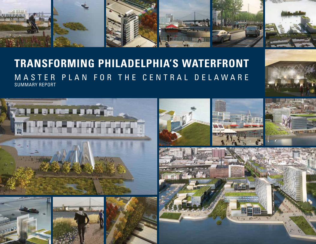
TRANSFORMINg PHILADELPHIA’S WATERFRONT M A S T E R P L A N F O R T H E C E N T R A L D E L A W A R ESuMMARy REPORT

Delaware River Waterfront Corporation
Thomas Corcoran President
Joe Forkin Vice President for Operations and Development
Jodie Milkman Vice President for Marketing, Programming, and Corporate Partnerships
Sarah Thorp Director of Planning
Delaware River Waterfront Corporation Board of Directors
Rina Cutler Deputy Mayor for Transportation and Utilities, City of Philadelphia
Avi D. Eden Law and Finance Consultant
Terry Gillen Director of Federal Affairs, Office of the Mayor, City of Philadelphia
Jay R. Goldstein Board Vice Chairman, Founder, President, and CEO of Valley Green Bank
Alan Greenberger Deputy Mayor for Economic Development, City of Philadelphia
William P. Hankowsky Chairman, President, and Chief Executive Officer of Liberty Property Trust
Michael I. Hauptman, AIA Partner, Brawer & Hauptman Architects
Alan P. Hoffmann President, VITETTA Architects/Engineers
Gary J. Jastrzab Executive Director of the Philadelphia City Planning Commission
William R. Miller, IV CEO, Ross Associates, Inc.
Donn G. Scott Board Chairman, Executive Vice President, Mid-Atlantic Banking Group, Wells Fargo
Marilyn Jordan Taylor Dean and Paley Professor, University of Pennsylvania School of Design
William L. Wilson Principal-in-Charge, Synterra Ltd.
Diane Dalto Woosnam Immediate Past Chair, Pennsylvania Council on the Arts
Ellen Yin Owner, Fork Restaurant and Fork:etc
Mario Zacharjasz, AIA Co-founder and Principal, PZS Architects, LLC; President of Puente Construction Enterprises, Inc.
December 2011
This report is a summary report of the Master Plan for
the Central Delaware. The full 300-page report and its
appendices can be downloaded at:
www.plancentraldelaware.com
The Delaware River Waterfront Corporation (DRWC)
commissioned the preparation of this master plan, which
was overseen by the DRWC Board of Directors. The proj-
ect was led by the Planning Committee of the Board of
Directors, supported by the DRWC president and staff.
The project was funded by the William Penn Foundation.
Delaware River Waterfront Corporation (DRWC) is a non-
profit corporation organized exclusively for the benefit of
the city of Philadelphia and its citizens. The fundamental
purpose of DRWC is to design, develop, and manage the
central Delaware River waterfront in Philadelphia between
Oregon and Allegheny Avenues. DRWC intends to trans-
form the central Delaware River waterfront into a vibrant
destination location for recreational, cultural, and com-
mercial activities for Philadelphia’s residents and visitors.
DRWC will serve as a catalyst for high-quality investment
in public parks and trails as well as maritime, residential,
retail, hotel, and other improvements that will create a vi-
brant amenity, extending Philadelphia to the river’s edge.
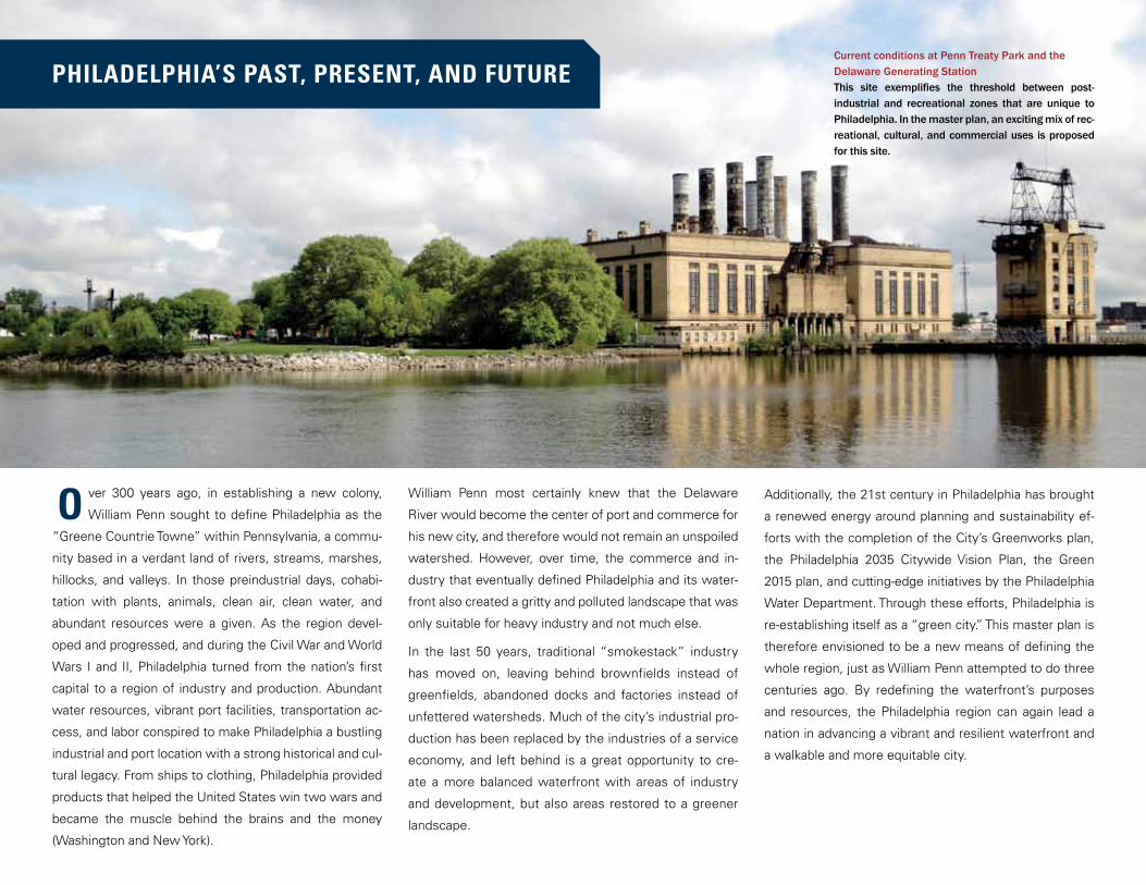
PHILADELPHIA’S PAST, PRESENT, AND FUTURE
ver 300 years ago, in establishing a new colony,
William Penn sought to define Philadelphia as the
“Greene Countrie Towne” within Pennsylvania, a commu-
nity based in a verdant land of rivers, streams, marshes,
hillocks, and valleys. In those preindustrial days, cohabi-
tation with plants, animals, clean air, clean water, and
abundant resources were a given. As the region devel-
oped and progressed, and during the Civil War and World
Wars I and II, Philadelphia turned from the nation’s first
capital to a region of industry and production. Abundant
water resources, vibrant port facilities, transportation ac-
cess, and labor conspired to make Philadelphia a bustling
industrial and port location with a strong historical and cul-
tural legacy. From ships to clothing, Philadelphia provided
products that helped the United States win two wars and
became the muscle behind the brains and the money
(Washington and New York).
William Penn most certainly knew that the Delaware
River would become the center of port and commerce for
his new city, and therefore would not remain an unspoiled
watershed. However, over time, the commerce and in-
dustry that eventually defined Philadelphia and its water-
front also created a gritty and polluted landscape that was
only suitable for heavy industry and not much else.
In the last 50 years, traditional “smokestack” industry
has moved on, leaving behind brownfields instead of
greenfields, abandoned docks and factories instead of
unfettered watersheds. Much of the city’s industrial pro-
duction has been replaced by the industries of a service
economy, and left behind is a great opportunity to cre-
ate a more balanced waterfront with areas of industry
and development, but also areas restored to a greener
landscape.
Current conditions at Penn Treaty Park and the Delaware Generating StationThis site exemplifies the threshold between post-industrial and recreational zones that are unique to Philadelphia. In the master plan, an exciting mix of rec-reational, cultural, and commercial uses is proposed for this site.
Additionally, the 21st century in Philadelphia has brought
a renewed energy around planning and sustainability ef-
forts with the completion of the City’s Greenworks plan,
the Philadelphia 2035 Citywide Vision Plan, the Green
2015 plan, and cutting-edge initiatives by the Philadelphia
Water Department. Through these efforts, Philadelphia is
re-establishing itself as a “green city.” This master plan is
therefore envisioned to be a new means of defining the
whole region, just as William Penn attempted to do three
centuries ago. By redefining the waterfront’s purposes
and resources, the Philadelphia region can again lead a
nation in advancing a vibrant and resilient waterfront and
a walkable and more equitable city.
O
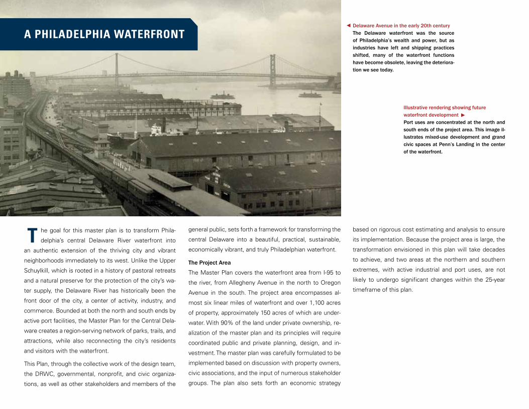
he goal for this master plan is to transform Phila-
delphia’s central Delaware River waterfront into
an authentic extension of the thriving city and vibrant
neighborhoods immediately to its west. Unlike the Upper
Schuylkill, which is rooted in a history of pastoral retreats
and a natural preserve for the protection of the city’s wa-
ter supply, the Delaware River has historically been the
front door of the city, a center of activity, industry, and
commerce. Bounded at both the north and south ends by
active port facilities, the Master Plan for the Central Dela-
ware creates a region-serving network of parks, trails, and
attractions, while also reconnecting the city’s residents
and visitors with the waterfront.
This Plan, through the collective work of the design team,
the DRWC, governmental, nonprofit, and civic organiza-
tions, as well as other stakeholders and members of the
general public, sets forth a framework for transforming the
central Delaware into a beautiful, practical, sustainable,
economically vibrant, and truly Philadelphian waterfront.
The Project Area
The Master Plan covers the waterfront area from I-95 to
the river, from Allegheny Avenue in the north to Oregon
Avenue in the south. The project area encompasses al-
most six linear miles of waterfront and over 1,100 acres
of property, approximately 150 acres of which are under-
water. With 90% of the land under private ownership, re-
alization of the master plan and its principles will require
coordinated public and private planning, design, and in-
vestment. The master plan was carefully formulated to be
implemented based on discussion with property owners,
civic associations, and the input of numerous stakeholder
groups. The plan also sets forth an economic strategy
based on rigorous cost estimating and analysis to ensure
its implementation. Because the project area is large, the
transformation envisioned in this plan will take decades
to achieve, and two areas at the northern and southern
extremes, with active industrial and port uses, are not
likely to undergo significant changes within the 25-year
timeframe of this plan.
Delaware Avenue in the early 20th centuryThe Delaware waterfront was the source of Philadelphia’s wealth and power, but as industries have left and shipping practices shifted, many of the waterfront functions have become obsolete, leaving the deteriora-tion we see today.
Illustrative rendering showing future waterfront developmentPort uses are concentrated at the north and south ends of the project area. This image il-lustrates mixed-use development and grand civic spaces at Penn’s Landing in the center of the waterfront.
A PHILADELPHIA WATERFRONT
T
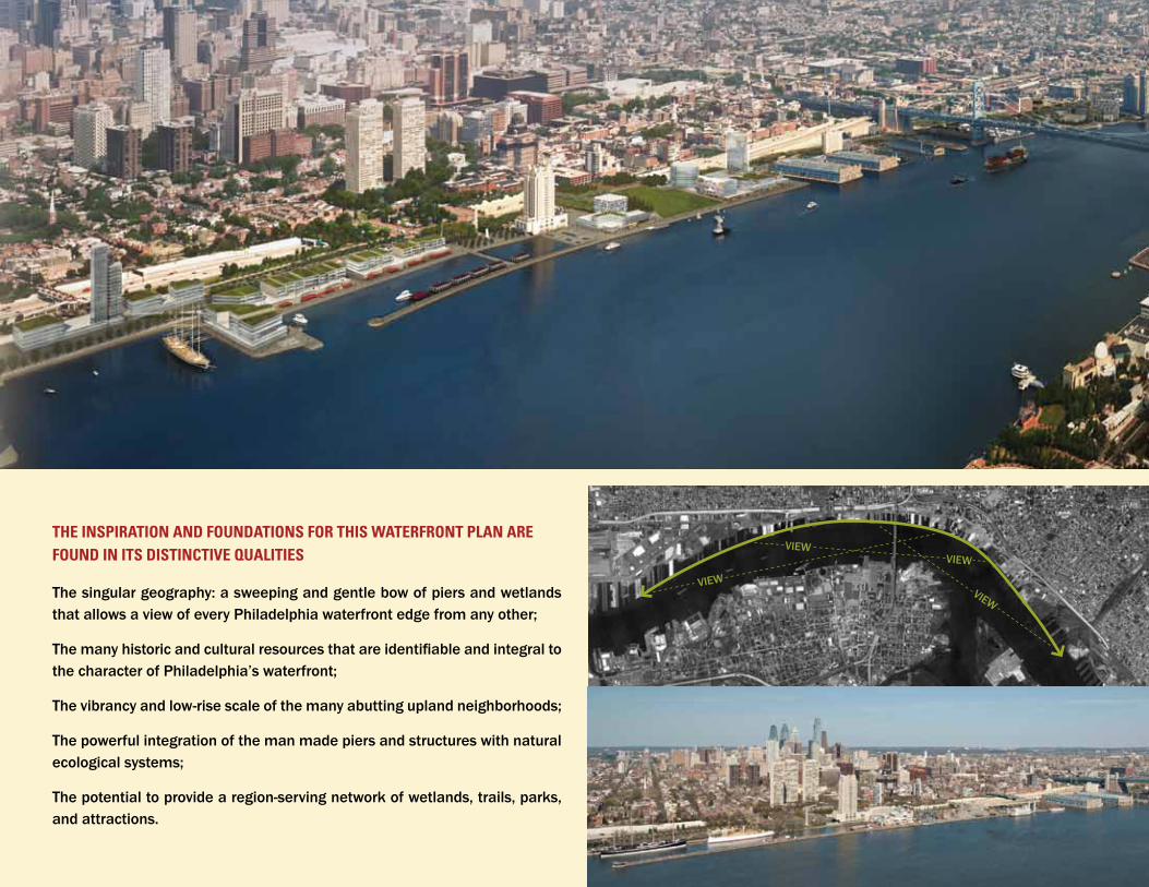
THE INSPIRATION AND FOUNDATIONS FOR THIS WATERFRONT PLAN ARE
The singular geography: a sweeping and gentle bow of piers and wetlands that allows a view of every Philadelphia waterfront edge from any other;
The many historic and cultural resources that are identifiable and integral to the character of Philadelphia’s waterfront;
The vibrancy and low-rise scale of the many abutting upland neighborhoods;
The powerful integration of the man made piers and structures with natural ecological systems;
The potential to provide a region-serving network of wetlands, trails, parks, and attractions.
FOUND IN ITS DISTINCTIVE QUALITIESVIEW
VIEW
VIEWVIEW
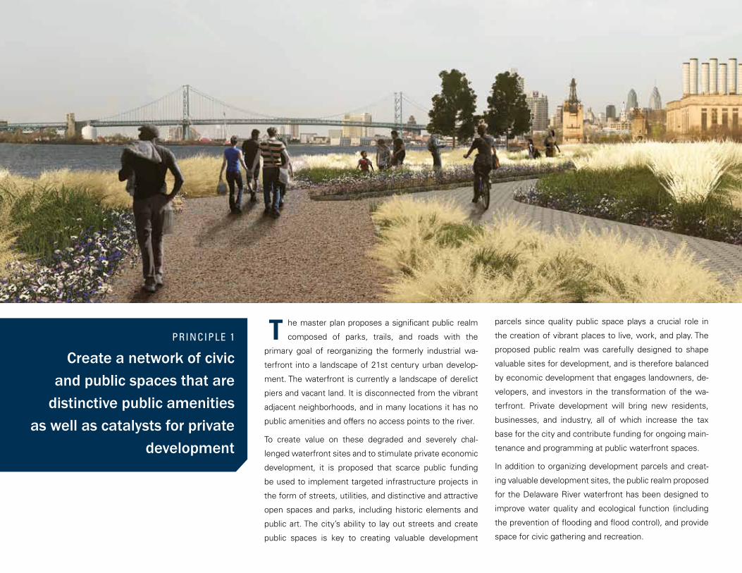
he master plan proposes a significant public realm
composed of parks, trails, and roads with the
primary goal of reorganizing the formerly industrial wa-
terfront into a landscape of 21st century urban develop-
ment. The waterfront is currently a landscape of derelict
piers and vacant land. It is disconnected from the vibrant
adjacent neighborhoods, and in many locations it has no
public amenities and offers no access points to the river.
To create value on these degraded and severely chal-
lenged waterfront sites and to stimulate private economic
development, it is proposed that scarce public funding
be used to implement targeted infrastructure projects in
the form of streets, utilities, and distinctive and attractive
open spaces and parks, including historic elements and
public art. The city’s ability to lay out streets and create
public spaces is key to creating valuable development
parcels since quality public space plays a crucial role in
the creation of vibrant places to live, work, and play. The
proposed public realm was carefully designed to shape
valuable sites for development, and is therefore balanced
by economic development that engages landowners, de-
velopers, and investors in the transformation of the wa-
terfront. Private development will bring new residents,
businesses, and industry, all of which increase the tax
base for the city and contribute funding for ongoing main-
tenance and programming at public waterfront spaces.
In addition to organizing development parcels and creat-
ing valuable development sites, the public realm proposed
for the Delaware River waterfront has been designed to
improve water quality and ecological function (including
the prevention of flooding and flood control), and provide
space for civic gathering and recreation.
PRINCIPLE 1
Create a network of civic and public spaces that are
distinctive public amenities as well as catalysts for private
development
T

Neighborhood parks
Wetlands
Public realm
Active recreation zones
Multi-use trail
Open space plan and trails mapOpen space in the master plan was designed to ac-commodate diverse uses. The plan shows wetlands in appropriate locations where piers are deteriorated, civic spaces at the center, and neighborhood parks spread throughout.
parks in 5.8 miles3 existing parks
10 new parks with diverse typologies: wetland parks, civic plazas, neighborhood spaces,
recreation areas
13
acres of open space
64.2 acres of neighborhood parks
31.7 acres of multi-use trail parks
plus 24 acres under I-95
96
miles of multi-usetrails
1 mile inside neighborhood park
1.9 miles inside multi-use trail parks
1.9 miles along Columbus Blvd
4.8The public realm consists of two components:
The Delaware River Park and Trail system is a network of
parks located approximately every half-mile along the wa-
terfront at the ends of key streets, connected by a contin-
uous bicycle and trail network. The trails and parks adjoin
river environments that protect habitats, provide addi-
tional wetlands, offer access, and support water-related
activities in a forward-looking, ecologically diverse setting.
A network of existing and new streets, including a new
waterfront drive south of Washington Avenue and north of
Penn Treaty Park, provide direct access to the waterfront
and development sites.
•
•
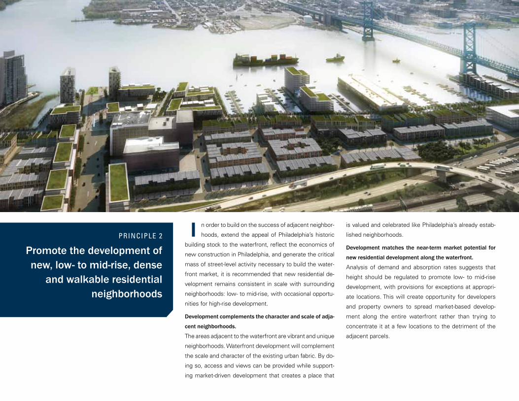
n order to build on the success of adjacent neighbor-
hoods, extend the appeal of Philadelphia’s historic
building stock to the waterfront, reflect the economics of
new construction in Philadelphia, and generate the critical
mass of street-level activity necessary to build the water-
front market, it is recommended that new residential de-
velopment remains consistent in scale with surrounding
neighborhoods: low- to mid-rise, with occasional opportu-
nities for high-rise development.
Development complements the character and scale of adja-
cent neighborhoods.
The areas adjacent to the waterfront are vibrant and unique
neighborhoods. Waterfront development will complement
the scale and character of the existing urban fabric. By do-
ing so, access and views can be provided while support-
ing market-driven development that creates a place that
PRINCIPLE 2
Promote the development of new, low- to mid-rise, dense
and walkable residential neighborhoods
is valued and celebrated like Philadelphia’s already estab-
lished neighborhoods.
Development matches the near-term market potential for
new residential development along the waterfront.
Analysis of demand and absorption rates suggests that
height should be regulated to promote low- to mid-rise
development, with provisions for exceptions at appropri-
ate locations. This will create opportunity for developers
and property owners to spread market-based develop-
ment along the entire waterfront rather than trying to
concentrate it at a few locations to the detriment of the
adjacent parcels.
I
Waterfront development is intended to complement, not
compete with, Center City or other neighborhood and dis-
trict developments.
A program of residential development with supporting
service retail, cafes, restaurants, and entertainment will
establish a year-round destination for the city and the re-
gion. The plan does not propose high-rise office develop-
ment, as this use should be promoted for Center City;
nor large-format retail, which already serves other city
neighborhoods. Reclaiming the riverfront for 21st century
urban living, complemented by ongoing and new water-
related and existing and new industrial activities, will cre-
ate jobs and offer a resilient and lasting place along the
Delaware River.
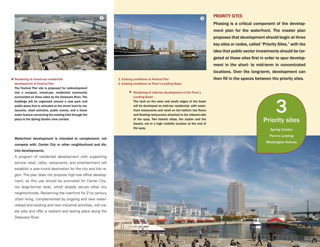
Rendering of mid-rise development at the Penn’s Landing BasinThe land on the west and south edges of the basin will be developed as mid-rise residential, with water-front restaurants and retail on the bottom two floors and floating restaurants attached to the inboard side of the quay. Two historic ships, the Jupiter and the Gazela, are in a high visibility location at the end of the quay.
Rendering of mixed-use residential development at Festival PierThe Festival Pier site is proposed for redevelopment into a compact, mixed-use, residential community surrounded on three sides by the Delaware River. The buildings will be organized around a new park and public plaza that is activated at the street level by res-taurants, retail activities, public events, and a linear water feature connecting the existing inlet through the plaza to the Spring Garden view corridor.
PRIORITY SITES1 2
Phasing is a critical component of the develop-ment plan for the waterfront. The master plan proposes that development should begin at three key sites or nodes, called “Priority Sites,” with the idea that public sector investments should be tar-geted at these sites first in order to spur develop-ment in the short- to mid-term in concentrated locations. Over the long-term, development can then fill in the spaces between the priority sites.1. Existing conditions at Festival Pier
2. Existing conditions at Penn’s Landing Basin
Priority sitesSpring Garden
Penn’s Landing
Washington Avenue
3
he master plan recognizes the need to incorporate
important land uses such as port, industry, and
commerce, as well as entertainment, residential, and
neighborhood-scale commercial. Uses that are somewhat
incompatible with each other will have transition zones in
between; the land-use plan has been designed to mini-
mize these conflicts of character and use.
At the north end, a buffer of office/industrial use is proposed
just south of the active port use, and civic/institutional use
is shown as a transition to the more neighborhood-scale
development. At the south end, existing large-format re-
tail provides a short-term buffer from port/industrial areas.
The proposed long-term buffer is park space, which can
provide an observation and interpretation platform for the
public to see and understand the role that the port and
maritime industry plays in the region’s economy.
PRINCIPLE 3
Accommodate diverse land uses along the waterfront
The rest of the waterfront is proposed as a mixture of resi-
dential, entertainment, and retail uses organized around
a network of high-quality open space and served by an
improved transportation system.
Rendering of mixed-use development in the Penn Treaty District The adaptive reuse of the historic Delaware Gener-ating Station next to Penn Treaty Park, which would be acquired from PECO at the end of its remaining life and redeveloped into a vibrant mix of cultural, museum, archival, office, studio, gallery, retail, and entertainment uses.
T
Queen Street
Dock Street
Christian Street
Washington A
venue
Reed Street
Front Street
Tasker Street
Dickinson Street
Mifflin Street
Snyder Avenue
Swanson Street
2nd Street
3rd Street
4th Street
5th Street
I-95
Delaware Avenue/Columbus Boulevard
6th Street
Oregon A
venue
Callow
hill Street
Benjam
in Franklin Bridge
Race Street
Market Street
Chestnut Street
Walnut Street
Spruce Street
South Street
7th Street
8th Street
Germantown Avenue
Frankford Avenue
Shackamaxon Street
Marlborough Stre
et
Laurel Street
Fairmount A
venue
Spring Garden Street
Columbia Avenue
Lehig
h Ave
nue
Huntin
gdon
Stre
et
Cumbe
rland
Stre
etBerks Stre
etMontgomery Avenue
Palmer Stre
etGirard Avenue
Som
erse
t Ave
nue
Cambr
ia St
reet
Ann Street
Aramingo Avenue
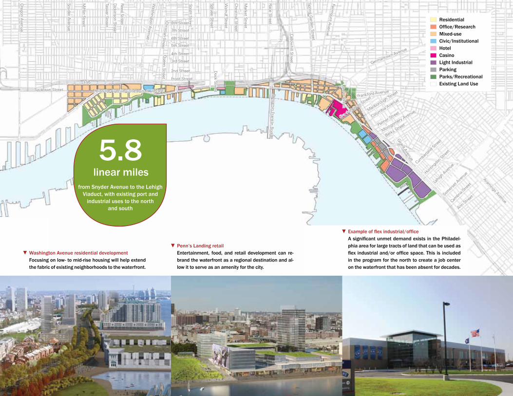
Washington Avenue residential developmentFocusing on low- to mid-rise housing will help extend the fabric of existing neighborhoods to the waterfront.
Penn’s Landing retailEntertainment, food, and retail development can re-brand the waterfront as a regional destination and al-low it to serve as an amenity for the city.
Example of flex industrial/officeA significant unmet demand exists in the Philadel-phia area for large tracts of land that can be used as flex industrial and/or office space. This is included in the program for the north to create a job center on the waterfront that has been absent for decades.
linear milesfrom Snyder Avenue to the Lehigh
Viaduct, with existing port and industrial uses to the north
and south
5.8
ResidentialOffice/ResearchMixed-useCivic/InstitutionalHotelCasinoLight IndustrialParkingParks/RecreationalExisting Land Use
ustainability is an underlying theme of the entire
master plan. Every aspect has been designed to en-
sure a diverse and vibrant ecology, economy, and culture
in Philadelphia well into the future, demonstrating an envi-
ronmentally ethical attitude toward our natural resources.
Parks, Open Space, and Watershed Restoration
The Delaware River is an important foundation of the
entire region’s ecology; therefore, in addition to recre-
ational goals, the proposed network of parks and open
space is designed to accomplish environmental goals.
Open space will help manage stormwater, prevent flood-
ing, restore natural ecologies, contribute to the health of
the river, reduce the city’s heat island effect, and restore
tree canopy. In urban areas like Philadelphia, hundreds of
years of river-based commerce has resulted in hardened
waterfront edges of bulkheads and piers. More recently,
PRINCIPLE 4
Incorporate best practices in sustainability
shifts in port activity and forms of industrial use present
the opportunity to restore a more natural edge in locations
where bulkheads and piers are no longer needed. The
master plan incorporates a strategy of inserting wetlands
into specific locations that will serve to protect urban and/
or industrial areas to mitigate flooding events as well as
future changes in river conditions.
Development Patterns
The type of development planned for the waterfront not
only establishes new, vibrant economic development for
the city, but also creates urban and walkable communi-
ties, reduces vehicular emissions through improved mass
transit, incorporates new and emerging green building
technologies into building design, and utilizes the exist-
ing history and character of the waterfront to inform new
development.
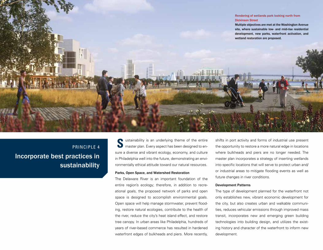
Rendering of wetlands park looking north from Dickinson StreetMultiple objectives are met at the Washington Avenue site, where sustainable low- and mid-rise residential development, new parks, waterfront activation, and wetland restoration are proposed.
S
Sustainable Development
The master plan encourages resource conservation by
promoting innovative, high-performance goals for all new
development. The plan proposes that the city implement
policies for sustainable building, site, and neighborhood
design that would become more robust as the master plan
and its time frame extends and as public policy regarding
the commitment to sustainability deepens. Initially devel-
opment would be encouraged to take advantage of green
building bonuses such as LEED Gold or Platinum (or equiv-
alent ratings systems) as set forth in Philadelphia’s new
zoning code. Eventually, sustainability should become a
full-fledged and integral requirement of the Philadelphia
Zoning and Building Codes for the waterfront district. The
highlights of this recommended policy for projects in the
waterfront district include actions that address air quality,
water quality and management, new development, dis-
trict and regional history, energy, regional transportation,
accessibility, and open space and recreation.
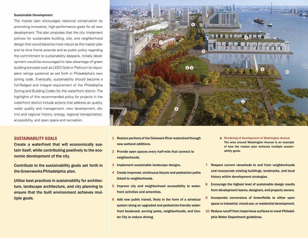
Rendering of development at Washington AvenueThe area around Washington Avenue is an example of how the master plan achieves multiple sustain-ability goals.
Restore portions of the Delaware River watershed through
new wetland additions.
Provide open spaces every half-mile that connect to
neighborhoods.
Implement sustainable landscape designs.
Create improved, continuous bicycle and pedestrian paths
linked to neighborhoods.
Improve city and neighborhood accessibility to water-
front activities and amenities.
Add new public transit, likely in the form of a streetcar
system along an upgraded and pedestrian-friendly water-
front boulevard, serving parks, neighborhoods, and Cen-
ter City to reduce driving.
1
1
2
3
4
5
6
7
8
9
10
2
5
6
8
910
7
3
4
Respect current viewsheds to and from neighborhoods
and incorporate existing buildings, landmarks, and local
history within development strategies.
Encourage the highest level of sustainable design results
from development teams, designers, and property owners.
Incorporate conversions of brownfields to either open
space or industrial, mixed-use, or residential development.
Reduce runoff from impervious surfaces to meet Philadel-
phia Water Department guidelines.
SUSTAINABILITY GOALSCreate a waterfront that will economically sus-tain itself, while contributing positively to the eco-nomic development of the city.
Contribute to the sustainability goals set forth in the Greenworks Philadelphia plan.
Utilize best practices in sustainability for architec-ture, landscape architecture, and city planning to ensure that the built environment achieves mul-tiple goals.
he current waterfront transportation system is auto-
centric, and the master plan recommends changes
that support improved and balanced access to the water-
front for pedestrians, bicyclists, and transit riders as well
as automobiles. Delaware Avenue/Columbus Boulevard
is envisioned as a true waterfront boulevard with transit,
bicycle lanes, and improved sidewalks to provide multi-
modal access along the waterfront. A high-quality transit
system with buses and streetcar service is envisioned to
run the length of the waterfront and connect the water-
front to the city’s core. In addition, a continuous multi-use
trail is proposed to extend the length of the waterfront as
close to the water’s edge as possible, while water-taxis
and ferries will link waterfront destinations in both Phila-
delphia and Camden. Also key to the transportation plan
is addressing the barrier of I-95 through high-impact light-
PRINCIPLE 5
Participate with city and state transportation entities to
create a pedestrian-friendly and balanced transportation
plan that supports the walkability of the waterfront and its strong connection to
the city and the region
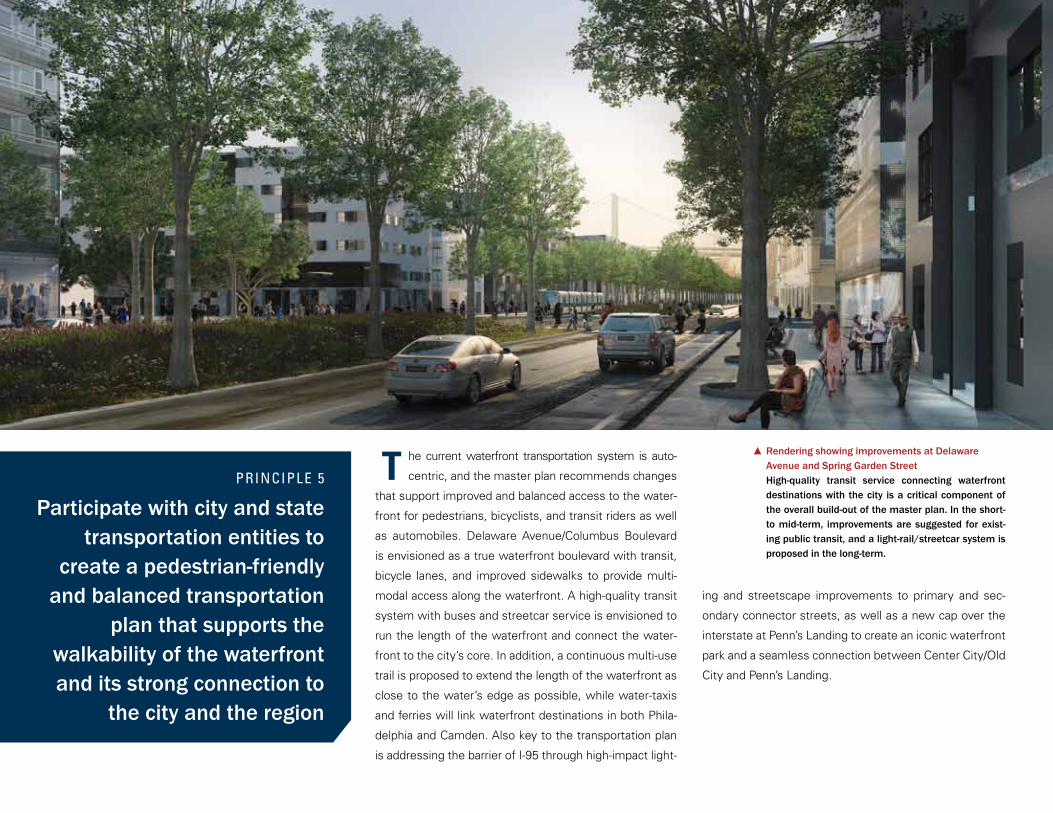
Rendering showing improvements at Delaware Avenue and Spring Garden StreetHigh-quality transit service connecting waterfront destinations with the city is a critical component of the overall build-out of the master plan. In the short- to mid-term, improvements are suggested for exist-ing public transit, and a light-rail/streetcar system is proposed in the long-term.
ing and streetscape improvements to primary and sec-
ondary connector streets, as well as a new cap over the
interstate at Penn’s Landing to create an iconic waterfront
park and a seamless connection between Center City/Old
City and Penn’s Landing.
T

Priority connector streetsConnector streets
Street ImprovementsEast-west connector streets require a high level of improvement in order to provide safe pedestrian and bicycle passage and to offer a high-impact, well-designed sense of welcome. Primary connec-tor streets end at waterfront parks and will be improved within the first ten years of the master plan, creating a much more permeable feeling around the interstate infrastructure. Significantly improving these key streets will allow residents and tourists to safely and eas-ily access the length of the waterfront.
Penn’s Landing ParkThe existing caps over I-95 are proposed to be ex-panded to completely cover the interstate between Chestnut and Walnut Streets, creating a new continu-ous park from Front Street to the water’s edge. This new infrastructure will also address the significant grade change between the city and the waterfront and help to mitigate the impact of I-95.
connector streets identified for improvement
16 primary and 22 secondary
To improve waterfront access from adjacent
neighborhoods
38
INTERSTATE MITIGATION
I-95 creates physical and perceptual barriers to water-
front access for residents and visitors alike. While there
are long-term plans to rebuild the highway south of Race
Street which are outside of the scope of the master plan,
the plan contains short- and mid-term solutions to miti-
gate the highway and improve access to the waterfront.
The plan’s connector streets, as well as the proposed cap
at the center for Penn’s Landing Park provide solutions to
difficult waterfront access and reduce the impact of I-95.
Christian Street
Queen Street
Washington A
venue
Benjam
in Franklin Bridge
Race Street
Market Street
Chestnut Street
Walnut Street
Spruce Street
South Street
Callow
hill Street
Germantown Avenue
Frankford AvenueShackamaxon Street
Marlborough Stre
et
Fairmount A
venue
Spring Garden Street
Columbia Avenue
Cumbe
rland
Stre
etBerks Stre
et
Montgomery AvenuePalmer S
treet
Brow
n Street
Dock Street

he redevelopment of the central Delaware water-
front presents a significant opportunity to advance
efforts to increase participation and investment by groups
that are traditionally not well represented in developments
of this scale.
PRINCIPLE 6
Create strong inclusionary opportunities for economic development for minority-
owned, women-owned, and disadvantaged businesses
Organization
DRWC will be guided by its organizational Economic
Opportunity Plan (EOP), which is currently in develop-
ment under a consultative contract with the Urban
Affairs Coalition. The EOP will establish a proactive
set of inclusionary goals and practices for DRWC’s
development and operations activities, as well as a
strong compliance monitoring and reporting system.
DRWC will undertake a marketing campaign to alert
M/W/DSBEs to upcoming opportunities to do busi-
ness with DRWC and will also incorporate into its
practices the guidelines and resources set forth in the
programs and documents developed by the City of
Philadelphia Office of Economic Opportunity.
Property Owner
DRWC’s most important, large-scale, and direct role
in wealth-building will derive from the private devel-
opment of land that DRWC and other public enti-
ties currently own. For this land, DRWC will issue
Requests for Proposals or Requests for Qualifica-
tions (RFPs/RFQs) for private developers and each
RFP/RFQ will include a set of wealth-building goals.
The selection process will include consideration
of a developer’s commitment to enter into a proj-
ect-specific EOP which would become part of the
project agreement.
Project Facilitator
Approximately 90 percent of the land covered by
the master plan is owned privately, and most of the
new development projected in the master plan will
be on these private parcels. In these cases, DRWC’s
ability to influence these private entities to engage
in inclusionary and wealth-building practices will be
much less direct.
DRWC can help the private developer gain access to
the appropriate sources of public funding for parks,
trails, roads, and utilities. In return, DRWC can use
such incentives to encourage private investors to in-
corporate inclusionary and wealth-building policies
into their development plans.
Inclusion Champion
The redevelopment of the central Delaware River
waterfront provides DRWC with the opportunity to
play a lead role in orchestrating and implementing
a wealth-building strategy that includes businesses
owned by minorities and women and that addresses
equity-investment opportunities for these communi-
ties. The three priority site projects outlined in the
master plan offer opportunities for members of the
local business community to be consultants, contrac-
tors, commercial tenants, and equity investors. The
overall economic and social impact of DRWC’s suc-
cessful implementation of its wealth-building strat-
egy can be profound.
T
$770
Mill
ion
PRINCIPLE 7
Create a plan that can be implemented in discrete
increments over time
very aspect of this plan was developed and de-
signed with implementation in mind. Therefore, as
part of the economics analysis, order of magnitude cost
estimates were completed for the public sector improve-
ments in the project area, utilizing specific criteria drawn
from comparable projects similar in size and scope. Costs
were then categorized and a financing strategy was devel-
oped for implementation.
A key principle of the master plan is to utilize public fund-
ing to build infrastructure that creates value in private
development sites, therefore encouraging and leverag-
ing private development. The amenities created with this
funding will also contribute to the quality of life in the city
as a whole. Public funding is scarce and a strategy was
carefully formulated to target funding first towards proj-
ects that leverage important private economic develop-
ment and second towards projects that would complete
the public realm as proposed in the plan.
The public investment for the implementation of the mas-
ter plan is estimated at $770 million, calculated in 2011
dollars, spread out over a 30-year period. This number
does not include costs of land assembly and acquisition
or of improvements to transportation systems, including
I-95 and the waterfront transit, which are elements of
other capital planning processes.
$348MFederal and State Grant Programs, Foundation/Private Contributions
$356MPublic Funding to Spur Private Development
$414MCompleting the Public Realm
$248MCity and State Capital Funding
$174MBonds Backed by Revenues
Project Expenses* Revenue Sources*
*In 2011 dollars, over a 30-year period
Race Street Pier
•
•
•
The Race Street Pier and Race Street Connector, a new
park and connector street completed in 2011, demon-
strate how public improvements can leverage private
economic development.
DRWC invested over $6 million in public and private
funding to build the Race Street Pier and $1.2 million
for Phase 1 of the Race Street Connector.
This area of the waterfront was previously a challenged
landscape of vacant and derelict buildings that are now
being transformed into public and private uses:
The Philadelphia Live Arts festival has bought the his-
toric building across the street from the Race Street
Pier and is renovating it to contain their offices, a
black box theater, and a café.
DRWC has received numerous inquiries about Pier 9,
the building directly south of the Race Street Pier, and
as a result is undertaking an architectural feasibility
study to redevelop the building.
DRWC intends to use the energy from these projects
along the Race Street corridor to incentivize other de-
velopments in this area.
LEVERAGING PRIVATE ECONOMICDEVELOPMENT
E
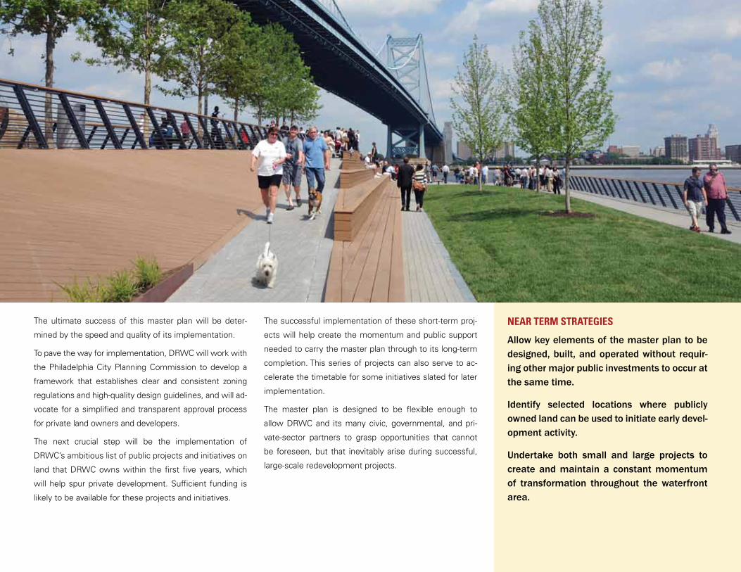
The ultimate success of this master plan will be deter-
mined by the speed and quality of its implementation.
To pave the way for implementation, DRWC will work with
the Philadelphia City Planning Commission to develop a
framework that establishes clear and consistent zoning
regulations and high-quality design guidelines, and will ad-
vocate for a simplified and transparent approval process
for private land owners and developers.
The next crucial step will be the implementation of
DRWC’s ambitious list of public projects and initiatives on
land that DRWC owns within the first five years, which
will help spur private development. Sufficient funding is
likely to be available for these projects and initiatives.
The successful implementation of these short-term proj-
ects will help create the momentum and public support
needed to carry the master plan through to its long-term
completion. This series of projects can also serve to ac-
celerate the timetable for some initiatives slated for later
implementation.
The master plan is designed to be flexible enough to
allow DRWC and its many civic, governmental, and pri-
vate-sector partners to grasp opportunities that cannot
be foreseen, but that inevitably arise during successful,
large-scale redevelopment projects.
NEAR TERM STRATEGIES
Allow key elements of the master plan to be designed, built, and operated without requir-ing other major public investments to occur at the same time.
Identify selected locations where publicly owned land can be used to initiate early devel-opment activity.
Undertake both small and large projects to create and maintain a constant momentum of transformation throughout the waterfront area.
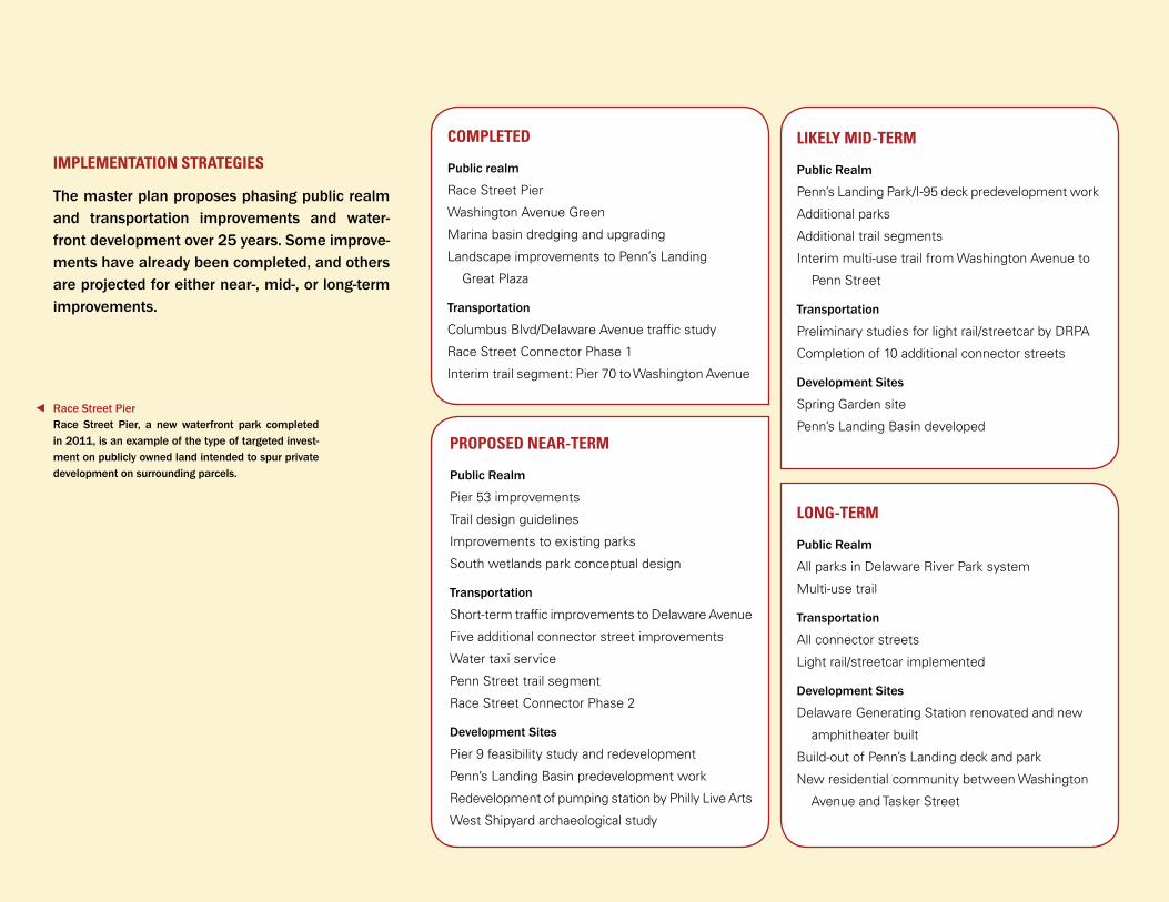
COMPLETED
Public realm
Race Street Pier
Washington Avenue Green
Marina basin dredging and upgrading
Landscape improvements to Penn’s Landing
Great Plaza
Transportation
Columbus Blvd/Delaware Avenue traffic study
Race Street Connector Phase 1
Interim trail segment: Pier 70 to Washington Avenue
Public Realm
Pier 53 improvements
Trail design guidelines
Improvements to existing parks
South wetlands park conceptual design
Transportation
Short-term traffic improvements to Delaware Avenue
Five additional connector street improvements
Water taxi service
Penn Street trail segment
Race Street Connector Phase 2
Development Sites
Pier 9 feasibility study and redevelopment
Penn’s Landing Basin predevelopment work
Redevelopment of pumping station by Philly Live Arts
West Shipyard archaeological study
PROPOSED NEAR-TERM
LIkELY MID-TERM
Public Realm
Penn’s Landing Park/I-95 deck predevelopment work
Additional parks
Additional trail segments
Interim multi-use trail from Washington Avenue to
Penn Street
Transportation
Preliminary studies for light rail/streetcar by DRPA
Completion of 10 additional connector streets
Development Sites
Spring Garden site
Penn’s Landing Basin developed
Public Realm
All parks in Delaware River Park system
Multi-use trail
Transportation
All connector streets
Light rail/streetcar implemented
Development Sites
Delaware Generating Station renovated and new
amphitheater built
Build-out of Penn’s Landing deck and park
New residential community between Washington
Avenue and Tasker Street
LONG-TERM
Race Street PierRace Street Pier, a new waterfront park completed in 2011, is an example of the type of targeted invest-ment on publicly owned land intended to spur private development on surrounding parcels.
The master plan proposes phasing public realm and transportation improvements and water-front development over 25 years. Some improve-ments have already been completed, and others are projected for either near-, mid-, or long-term improvements.
IMPLEMENTATION STRATEGIES
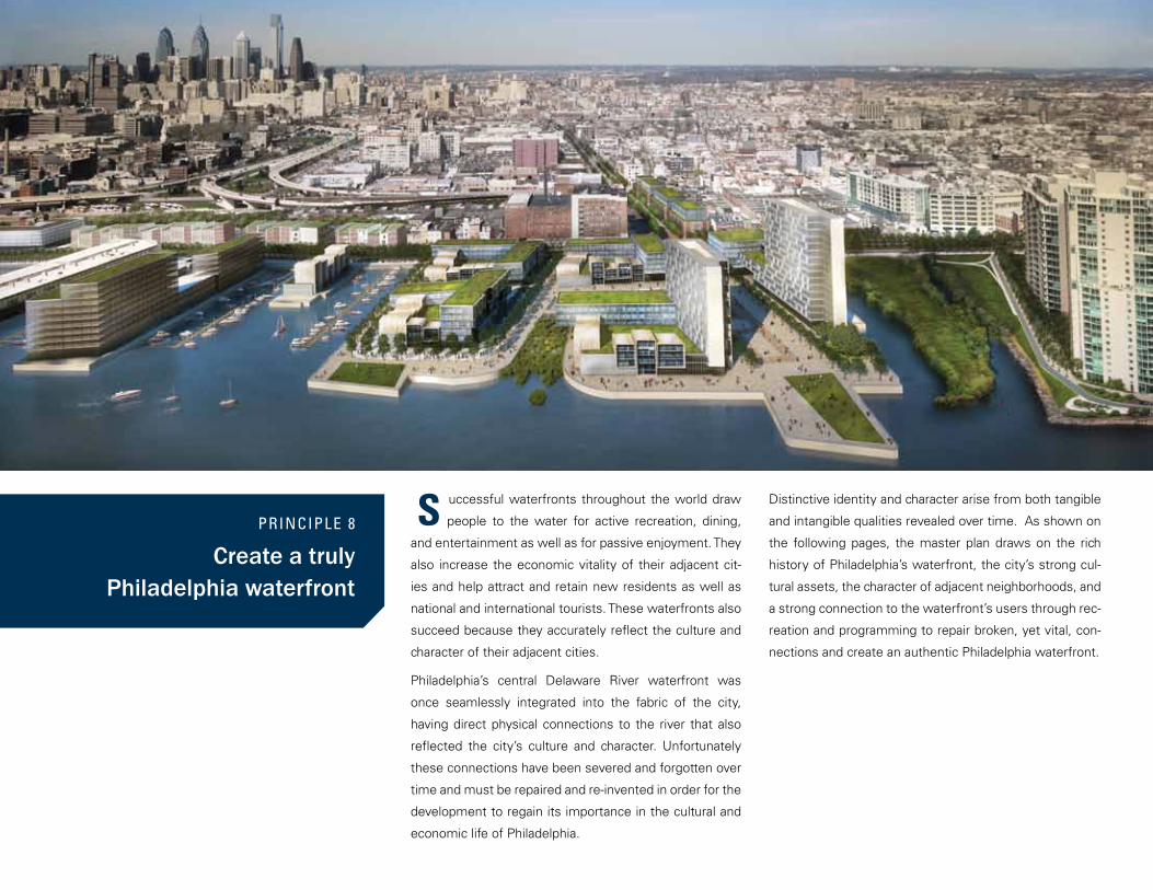
PRINCIPLE 8
Create a truly Philadelphia waterfront
Distinctive identity and character arise from both tangible
and intangible qualities revealed over time. As shown on
the following pages, the master plan draws on the rich
history of Philadelphia’s waterfront, the city’s strong cul-
tural assets, the character of adjacent neighborhoods, and
a strong connection to the waterfront’s users through rec-
reation and programming to repair broken, yet vital, con-
nections and create an authentic Philadelphia waterfront.
uccessful waterfronts throughout the world draw
people to the water for active recreation, dining,
and entertainment as well as for passive enjoyment. They
also increase the economic vitality of their adjacent cit-
ies and help attract and retain new residents as well as
national and international tourists. These waterfronts also
succeed because they accurately reflect the culture and
character of their adjacent cities.
Philadelphia’s central Delaware River waterfront was
once seamlessly integrated into the fabric of the city,
having direct physical connections to the river that also
reflected the city’s culture and character. Unfortunately
these connections have been severed and forgotten over
time and must be repaired and re-invented in order for the
development to regain its importance in the cultural and
economic life of Philadelphia.
S
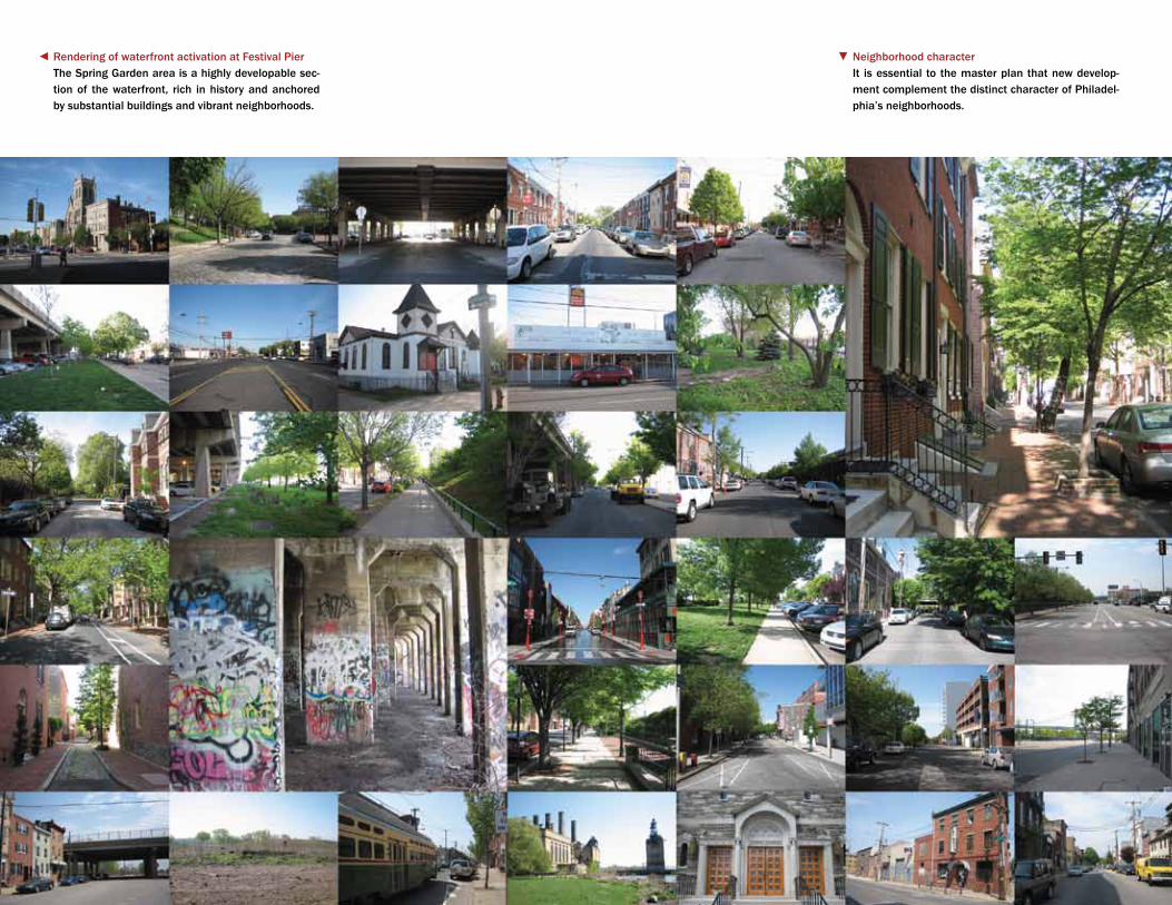
Rendering of waterfront activation at Festival PierThe Spring Garden area is a highly developable sec-tion of the waterfront, rich in history and anchored by substantial buildings and vibrant neighborhoods.
Neighborhood characterIt is essential to the master plan that new develop-ment complement the distinct character of Philadel-phia’s neighborhoods.
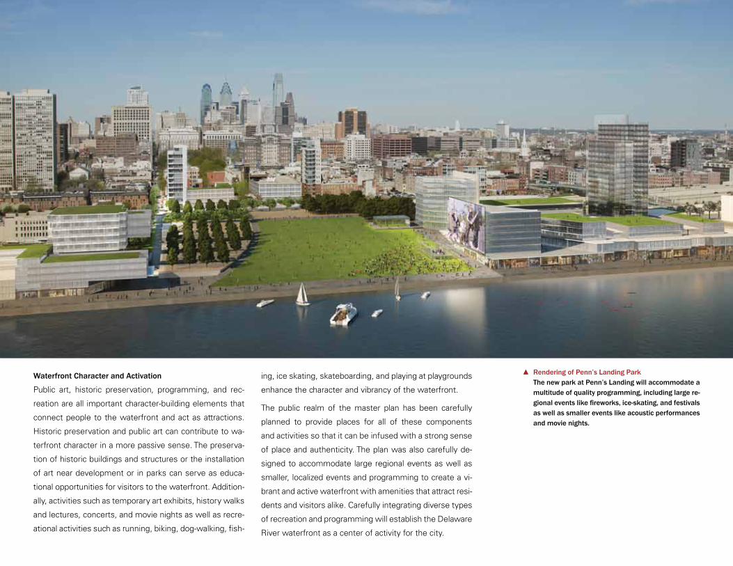
Waterfront Character and Activation
Public art, historic preservation, programming, and rec-
reation are all important character-building elements that
connect people to the waterfront and act as attractions.
Historic preservation and public art can contribute to wa-
terfront character in a more passive sense. The preserva-
tion of historic buildings and structures or the installation
of art near development or in parks can serve as educa-
tional opportunities for visitors to the waterfront. Addition-
ally, activities such as temporary art exhibits, history walks
and lectures, concerts, and movie nights as well as recre-
ational activities such as running, biking, dog-walking, fish-
ing, ice skating, skateboarding, and playing at playgrounds
enhance the character and vibrancy of the waterfront.
The public realm of the master plan has been carefully
planned to provide places for all of these components
and activities so that it can be infused with a strong sense
of place and authenticity. The plan was also carefully de-
signed to accommodate large regional events as well as
smaller, localized events and programming to create a vi-
brant and active waterfront with amenities that attract resi-
dents and visitors alike. Carefully integrating diverse types
of recreation and programming will establish the Delaware
River waterfront as a center of activity for the city.
Rendering of Penn’s Landing ParkThe new park at Penn’s Landing will accommodate a multitude of quality programming, including large re-gional events like fireworks, ice-skating, and festivals as well as smaller events like acoustic performances and movie nights.
Utilize the character of buildings in adja-cent neighborhoods to inform the scale and massing of new development.
Preserve and reuse significant buildings and structures by creating a preservation plan for the area and establish uniform policies to examine the cultural resources of areas slated for development.
Create an interpretive plan that will enhance the experience of the waterfront for residents and visitors.
Apply cultural resources best practices for projects on land owned by either DRWC or the city.
Incorporate the waterfront’s rich and di-verse history into the design of places to reinforce the waterfront’s uniquely Philadel-phia character.
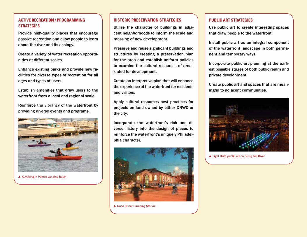
HISTORIC PRESERVATION STRATEGIES
Provide high-quality places that encourage passive recreation and allow people to learn about the river and its ecology.
Create a variety of water recreation opportu-nities at different scales.
Enhance existing parks and provide new fa-cilities for diverse types of recreation for all ages and types of users.
Establish amenities that draw users to the waterfront from a local and regional scale.
Reinforce the vibrancy of the waterfront by providing diverse events and programs.
ACTIVE RECREATION / PROGRAMMING STRATEGIES Use public art to create interesting spaces
that draw people to the waterfront.
Install public art as an integral component of the waterfront landscape in both perma-nent and temporary ways.
Incorporate public art planning at the earli-est possible stages of both public realm and private development.
Create public art and spaces that are mean-ingful to adjacent communities.
PUBLIC ART STRATEGIES
Kayaking in Penn’s Landing Basin
Race Street Pumping Station
Light Drift, public art on Schuylkill River
Benjam
in Franklin Bridge
Spring G
arden Street
Frankford Avenue
Germantown Avenue
Allegh
eny A
venu
e
Market S
treet
Washington A
venue
1
2
3
45 6
7
8
9
10
11
12
13
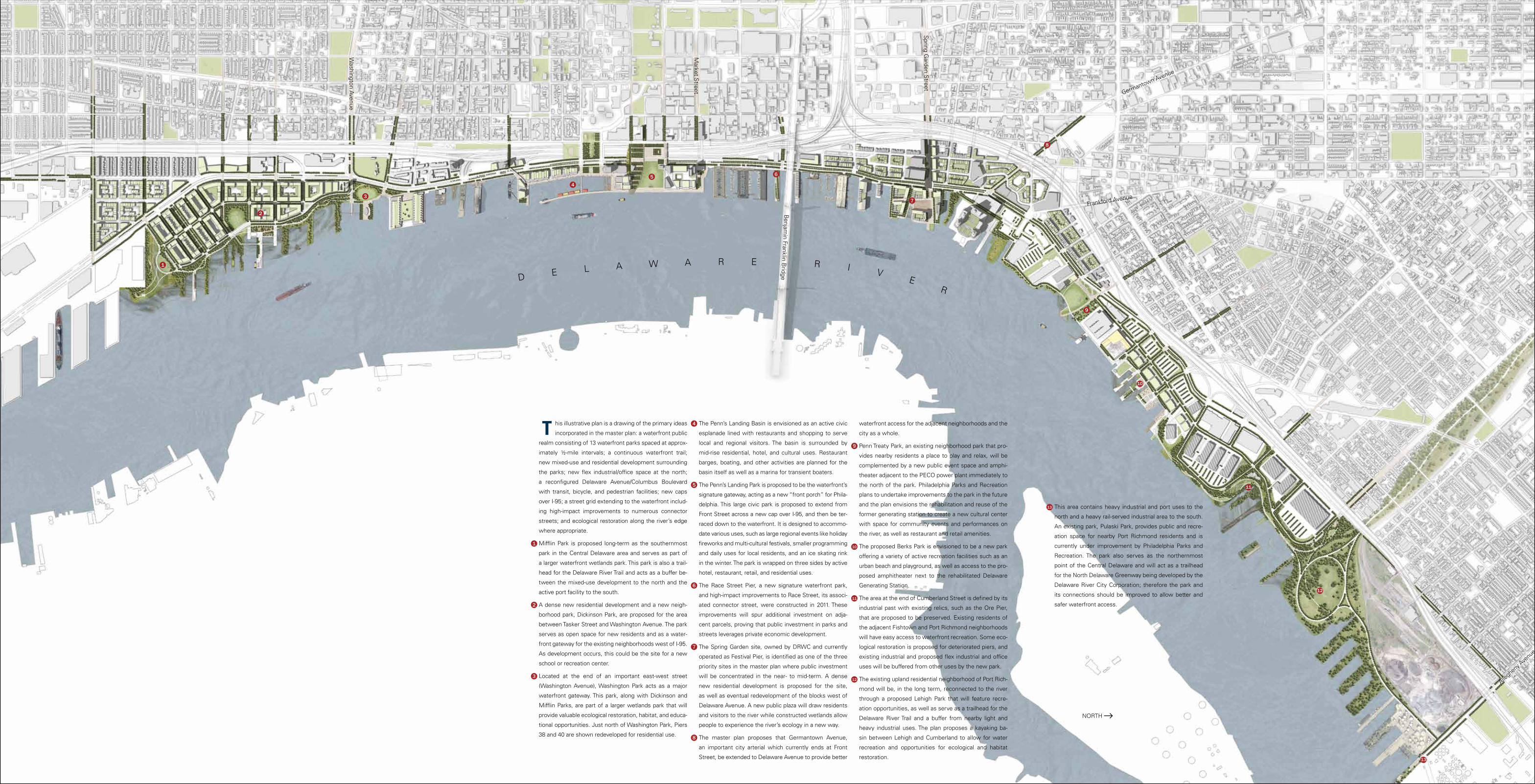
T his illustrative plan is a drawing of the primary ideas
incorporated in the master plan: a waterfront public
realm consisting of 13 waterfront parks spaced at approx-
imately ½-mile intervals; a continuous waterfront trail;
new mixed-use and residential development surrounding
the parks; new flex industrial/office space at the north;
a reconfigured Delaware Avenue/Columbus Boulevard
with transit, bicycle, and pedestrian facilities; new caps
over I-95; a street grid extending to the waterfront includ-
ing high-impact improvements to numerous connector
streets; and ecological restoration along the river’s edge
where appropriate.
Mifflin Park is proposed long-term as the southernmost
park in the Central Delaware area and serves as part of
a larger waterfront wetlands park. This park is also a trail-
head for the Delaware River Trail and acts as a buffer be-
tween the mixed-use development to the north and the
active port facility to the south.
A dense new residential development and a new neigh-
borhood park, Dickinson Park, are proposed for the area
between Tasker Street and Washington Avenue. The park
serves as open space for new residents and as a water-
front gateway for the existing neighborhoods west of I-95.
As development occurs, this could be the site for a new
school or recreation center.
Located at the end of an important east-west street
(Washington Avenue), Washington Park acts as a major
waterfront gateway. This park, along with Dickinson and
Mifflin Parks, are part of a larger wetlands park that will
provide valuable ecological restoration, habitat, and educa-
tional opportunities. Just north of Washington Park, Piers
38 and 40 are shown redeveloped for residential use.
The Penn’s Landing Basin is envisioned as an active civic
esplanade lined with restaurants and shopping to serve
local and regional visitors. The basin is surrounded by
mid-rise residential, hotel, and cultural uses. Restaurant
barges, boating, and other activities are planned for the
basin itself as well as a marina for transient boaters.
The Penn’s Landing Park is proposed to be the waterfront’s
signature gateway, acting as a new “front porch” for Phila-
delphia. This large civic park is proposed to extend from
Front Street across a new cap over I-95, and then be ter-
raced down to the waterfront. It is designed to accommo-
date various uses, such as large regional events like holiday
fireworks and multi-cultural festivals, smaller programming
and daily uses for local residents, and an ice skating rink
in the winter. The park is wrapped on three sides by active
hotel, restaurant, retail, and residential uses.
The Race Street Pier, a new signature waterfront park,
and high-impact improvements to Race Street, its associ-
ated connector street, were constructed in 2011. These
improvements will spur additional investment on adja-
cent parcels, proving that public investment in parks and
streets leverages private economic development.
The Spring Garden site, owned by DRWC and currently
operated as Festival Pier, is identified as one of the three
priority sites in the master plan where public investment
will be concentrated in the near- to mid-term. A dense
new residential development is proposed for the site,
as well as eventual redevelopment of the blocks west of
Delaware Avenue. A new public plaza will draw residents
and visitors to the river while constructed wetlands allow
people to experience the river’s ecology in a new way.
The master plan proposes that Germantown Avenue,
an important city arterial which currently ends at Front
Street, be extended to Delaware Avenue to provide better
waterfront access for the adjacent neighborhoods and the
city as a whole.
Penn Treaty Park, an existing neighborhood park that pro-
vides nearby residents a place to play and relax, will be
complemented by a new public event space and amphi-
theater adjacent to the PECO power plant immediately to
the north of the park. Philadelphia Parks and Recreation
plans to undertake improvements to the park in the future
and the plan envisions the rehabilitation and reuse of the
former generating station to create a new cultural center
with space for community events and performances on
the river, as well as restaurant and retail amenities.
The proposed Berks Park is envisioned to be a new park
offering a variety of active recreation facilities such as an
urban beach and playground, as well as access to the pro-
posed amphitheater next to the rehabilitated Delaware
Generating Station.
The area at the end of Cumberland Street is defined by its
industrial past with existing relics, such as the Ore Pier,
that are proposed to be preserved. Existing residents of
the adjacent Fishtown and Port Richmond neighborhoods
will have easy access to waterfront recreation. Some eco-
logical restoration is proposed for deteriorated piers, and
existing industrial and proposed flex industrial and office
uses will be buffered from other uses by the new park.
The existing upland residential neighborhood of Port Rich-
mond will be, in the long term, reconnected to the river
through a proposed Lehigh Park that will feature recre-
ation opportunities, as well as serve as a trailhead for the
Delaware River Trail and a buffer from nearby light and
heavy industrial uses. The plan proposes a kayaking ba-
sin between Lehigh and Cumberland to allow for water
recreation and opportunities for ecological and habitat
restoration.
This area contains heavy industrial and port uses to the
north and a heavy rail-served industrial area to the south.
An existing park, Pulaski Park, provides public and recre-
ation space for nearby Port Richmond residents and is
currently under improvement by Philadelphia Parks and
Recreation. The park also serves as the northernmost
point of the Central Delaware and will act as a trailhead
for the North Delaware Greenway being developed by the
Delaware River City Corporation; therefore the park and
its connections should be improved to allow better and
safer waterfront access.
NORTH
1
2
3
4
5
9
10
13
11
12
6
7
8
D E L A W A R E R I VE
R
Consulting Team
Cooper, Robertson & Partners Team Leader and Urban Designer
OLIN Landscape Architect
KieranTimberlake Architecture and Sustainability
HR&A Economics
Parsons Brinckerhoff Transportation
Hurley Franks & Associates Outreach
Urban Affairs Coalition Wealth-Building
Toni L. Griffin Waterfront Policy Advisor
KBE Activation Programming
KS Engineers Civil Engineer
CH Planning Planning
BlankRome Land Use Counsel
Kelly/Maiello Supporting Architect
Emily Cooperman, Ph.D. Historic Resources
Katherine Woodhouse-Beyer Ph.D., Archeological Resources
Davis Langdon Cost Estimator
Brooklyn Digital Foundry Renderer
The master plan was developed in close consultation with the following stakeholder groups:
Bicycle Coalition of Greater PhiladelphiaCentral Delaware Advocacy GroupCitizens for Pennsylvania’s FutureCity of Philadelphia Department of CommerceCity of Philadelphia Department of Parks and RecreationCity of Philadelphia Department of StreetsCity of Philadelphia Historical CommissionCity of Philadelphia Law DepartmentCity of Philadelphia Mayor’s Office of SustainabilityCity of Philadelphia Mayor’s Office of Transportation and UtilitiesCity of Philadelphia Office of Arts, Culture, and the Creative EconomyCity of Philadelphia Office of Economic OpportunityCity of Philadelphia Office of the MayorCourt at Old Swedes Homeowners’ AssociationDelaware River Port AuthorityDelaware River Yachtmen’s LeagueDelaware Valley Regional Planning CommissionDevelopment WorkshopFishtown Neighbors AssociationFranklin Bridge North Neighbors AssociationNeighbors Allied for the Best RiverfrontNew Kensington Community Development CorporationNorthern Liberties Neighbors AssociationOld City Civic AssociationPennPraxisPennsport Civic AssociationPennsylvania Department of Community and Economic DevelopmentPennsylvania Department of Conservation and Natural ResourcesPennsylvania Department of Environmental ProtectionPennsylvania Department of TransportationPennsylvania Environmental CouncilPennsylvania Horticultural SocietyPhiladelphia Archaeological ForumPhiladelphia City Planning CommissionPhiladelphia Industrial Development CorporationPhiladelphia Redevelopment AuthorityPhiladelphia Regional Port AuthorityPhiladelphia Water DepartmentPort Richmond on Patrol & Civic AssociationPreservation Alliance of Greater PhiladelphiaPublic Art ForumQueen Village Neighbors AssociationRiver’s Edge Community AssociationSociety Hill Civic AssociationSociety Hill Towers Homeowners’ AssociationSoutheastern Pennsylvania Transportation AuthoritySouth Street Headhouse Business DistrictWhitman Council
Many additional organizations and individuals have had input into this mas-ter plan and their contributions are recognized in the full report document.
Photo Credits
Images in the report not listed below were taken by members of the consulting team.
All renderings and aerial photos Brooklyn Digital Foundry
Delaware Avenue in the early 20th century Photo courtesy of PhillyHistory.org
Existing conditions at Penn’s Landing Basin Brooklyn Digital Foundry
Example of Light Industrial Photo courtesy of Liberty Property Trust
Race Street Pier (from bridge) Photo courtesy of James Corner Field Operations
Race Street Pier (from park) Photo courtesy of James Corner Field Operations and Edward Savaria Jr and Suzanne Savaria
Kayaking in Penn’s Landing Basin Photo courtesy of Pennsylvania Environmental Council
Race Street Pumping Station Photo courtesy of Wallace Roberts & Todd
Light Drift, public art on Schuylkill River Howeler + Yoon Architecture, Philadelphia Mural Arts, Photo courtesy of Joel Avery from CREATiVNES
Printed by Consolidated Drake Press in Philadelphia, Pennsylvania
Printed on Burgo Chorus Art Silk Text 100lb (25% post-consumer waste)
Composed in Univers, designed by Adrian Frutiger in 1954 and Franklin Gothic, designed by Morris Fuller Benton in 1902.
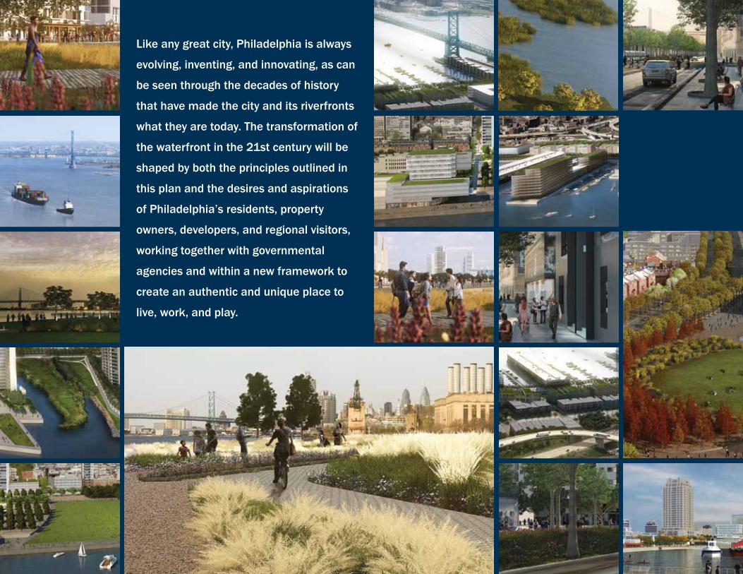
Like any great city, Philadelphia is always
evolving, inventing, and innovating, as can
be seen through the decades of history
that have made the city and its riverfronts
what they are today. The transformation of
the waterfront in the 21st century will be
shaped by both the principles outlined in
this plan and the desires and aspirations
of Philadelphia’s residents, property
owners, developers, and regional visitors,
working together with governmental
agencies and within a new framework to
create an authentic and unique place to
live, work, and play.