train map: mobile application for train map to …greenskill.net/suhailan/fyp/report/037720.pdf ·...
TRANSCRIPT

TRAIN MAP: MOBILE APPLICATION FOR TRAIN
MAP TO ASSIST THE PASSENGERS IN
NAVIGATING EFFICIENT JOURNEY
MUHAMMAD DANIAL BIN MOHD ZAIDI
FACULTY OF INFORMATICS AND COMPUTING
(INTERNET COMPUTING)
UNIVERSITY SULTAN ZAINAL ABIDIN
2017

TRAIN MAP: MOBILE APPLICATION FOR TRAIN MAP TO ASSIST THE
PASSENGERS IN NAVIGATING EFFICIENT JOURNEY.
MUHAMMAD DANIAL BIN MOHD ZAIDI
Bachelor of Computer Science Internet Computing (Hons)
Faculty of Informatics and Computing
Universiti Sultan Zainal Abidin, Terengganu, Malaysia
MAY 2017

I
APRROVAL
This project report entitled Online Medical Appointment for Pusat Kesihatan UniSZA
using Mobile Application was prepared and submitted by Muhammad Kamal Arif Bin
Razali, matric number BTCL14037719 and in my point of view, this project fulfils a
condition to be awarded a Bachelor of Computer Science (Internet Computing) with
Honor in Universiti Sultan Zainal Abidin (UniSZA).
Signature: ______________________
Supervisor: Dr. Azrul Amri Bin Jamal
Date:

II
DECLARATION
I hereby declare that this report is based on my original work except for quotations and
citations, which have been duly acknowledged. I also declare that it has not been
previously or concurrently submitted for any other degree at Universiti Sultan Zainal
Abidin or other institutions.
Signature :___________________________
Name : Muhammad Danial Bin Mohd Zaidi
Date : ..................................................

III
ACKNOWLEDGEMENT
In the name of Allah, the Most Gracious and the most Merciful, all praise is only for Him
the part of documentation and draft of system for the subject, TXF 1992, Projek Ilmiah
2016/2017 are able to be finished due the time. Never forget to my kind supervisor, Dr.
Azrul Amri Bin Jamal for valuable idea, time, support, advice, guidance and ideas given
through the development of research until complete the part of project in the phase one. In
addition, I want to dedicate my appreciation to my beloved family that support and
motivate me during process finishing project. Next, thanks a lot to friends that willing to
lend their hand for finish the project. Lastly, thank you to everyone who directly or
indirectly involved in the process of making the system and documentation.

IV
ABSTRACT
Public transportation in Malaysia is growing rapidly due to the increase of population and
the requirements of people to move swiftly from one place to another. Current railway
transport web in Malaysia is getting bigger from year to year. The railways lines
converged and intertwined with each other. Therefore, there might be several ways to
travel from one station to another. This can cause confusion for the railway users. The
objectives of this study are to analyses the shortest route of train to reach destination and
to design a mobile application train map to navigate the passengers giving the shortest
route to arrive the destination. Next, to develop an application which provides the choices
route for passengers to get the shortest route. Besides, to evaluate the distance of the
shortest route or the best route of the train to passengers arrive the destination. The
method being used is Dijkstra’s algorithm. It is an algorithm that used to find the shortest
path from one node to another node in a graph and it apply only on positive weights [1].
Technologies being used in this project are Global Positioning System (GPS), Global
System for Mobile Communication (GSM) and Android platform [4,5]. By the end of this
study, it is expected that the developed application can encourage the citizens to use the
train as the transportation besides assisting them to achieve their destination [2].

V
CONTENTS
APRROVAL ..........................................................................................................................................I
DECLARATION ...................................................................................................................................II
ACKNOWLEDGEMENT ......................................................................................................................III
ABSTRACT ........................................................................................................................................ IV
CONTENTS ........................................................................................................................................ V
LIST OF TABLES ............................................................................................................................... VII
LIST OF FIGURES ............................................................................................................................ VIII
LIST OF ABBREVIATIONS / TERMS / SYMBOLS ................................................................................ IX
CHAPTER 1 ........................................................................................................................................1
INTRODUCTION .................................................................................................................................1
1.1 Project Introduction ............................................................................................................1
1.2 Problem Statement .............................................................................................................2
1.3 Objectives............................................................................................................................2
1.4 Scope ...................................................................................................................................3
1.5 Expected Outcome ..............................................................................................................3
1.6 Summary .............................................................................................................................3
CHAPTER 2 ........................................................................................................................................4
LITERATURE REVIEW .........................................................................................................................4
2.1 Introduction ........................................................................................................................4
2.2 Rail Transportation..............................................................................................................4
2.3 Algorithm for Routes ...........................................................................................................7
2.4 Summary .............................................................................................................................8
CHAPTER 3 ........................................................................................................................................9
3.0 METHODOLOGY ..........................................................................................................................9
3.1 Methodology for Mobile Apps ................................................................................................9
3.1.1 Phase 1: User modelling phase ........................................................................................9
3.1.2 Phase 2: Conceptual Design Phase ............................................................................... 11
3.1.3 Phase 3: Implementation Design .................................................................................. 12
3.1.4 Phase 4: Implementation .............................................................................................. 13
3.2 Process Model ...................................................................................................................... 14

VI
3.2.1 Context Diagram ........................................................................................................... 14
3.2.2 Data Flow Diagram ........................................................................................................ 15
3.2.3 Entity Relationship Diagram.......................................................................................... 16
3.3 System Design ...................................................................................................................... 17
3.5 METHOD / TECHNIQUES .......................................................................................................... 21
REFERENCES ................................................................................................................................... 23

VII
LIST OF TABLES
TABLE TITLE PAGE
3.1 Data dictionary 16

VIII
LIST OF FIGURES
FIGURE TITLE PAGE
3.1 The relationship between of class and activities 10
3.2 The developer is going to use is ER model for building the
application.
11
3.3 Context diagram of application 14
3.4 Data flow diagram of application 15
3.5 Entity diagram Relationship diagram 16
3..6 Interface introduction of application – Loading 17
3.7 Interface second page of application - Searching 17
3.8 Interface suggestion result after search the location 18
3.9 Interface details result after user choose the route 18
3.10 Interface for admin – Login 19
3.11 Interface for Admin – Menu to update the info 19
3.12 Interface for form admin update the info 20
3.13 The diagram shows the operation of Dijkstra’s Algorithm 22
3.14 The diagram shows the operation of Dijkstra’s Algorithm 22
3.15 The diagram shows the operation of Dijkstra’s Algorithm 23

IX
LIST OF ABBREVIATIONS / TERMS / SYMBOLS
CD Context Diagram
DFD Data Flow Diagram
ERD Entity Relationship Diagram
ERL Express Rail Link
FYP Final year project
KTM Kereta Api Tanah Melayu
KL Kuala Lumpur
KLIA Kuala Lumpur International Airport
TN50 Transformasi Nasional 50
WSDM Web Semantic Design Method

1
CHAPTER 1
INTRODUCTION
1.1 Project Introduction
Malaysia is considered as a developing country. The Government implement
Tranformasi Nasional 2050 (TN50) that had been planned to transform Malaysia into an
advanced country. In order to achieve TN50, the field needed to be improved due time
such as education, medical, business, services, transportation, and others.
At the same time, Malaysia had been improving its public transport, and they are
focusing on rail transportation. The rail transportation focused on big cities and the most
important is in the Capital of Malaysia, Kuala Lumpur. Among rail transportation are
Commuter Rail, Rapid Transit, Light Rapid Transit, and Monorail [2].
Commuter Rail operates their service at two line namely Seremban line and Port
Klang line. The Rapid Transit provides its services at Sungai Buloh- Kajang Line.
Ampang Line and Kelana Jaya Line are handled by Light Rapid Transit. Monorail, serves
the KL Monorail Line which located in the city center. The Airport rail link provides the
transportation from KL Sentral to KLIA by KLIA Transit Line [2].
There are several issues arise with the advancement of cities train transport. The
rail network become more complex. So, many procedures needed to be solved before
using the trains, and as a sequences the fee also increases. There are also users who do not
know how to use the train, some users do not know where the train will stop, and where
to change train in order to get to their desired location. These users would ask person at
counter tickets in to solve their problems [6].
In conclusion, I will develop the mobile application is to navigate train passengers
to get the best route to reach their destination and simultaneously it can encourage the
citizens to use the train as the transportation.

2
1.2 Problem Statement
There is some problem statement can identify in the issue of advancement of cities
train transport. The rail network become more complex and have a few lines can bring
user to their location [3]. At the same moment, the number of train lines and station
increases. The users who not familiar use train will faced with some problems such as the
users waste their energy, time and money because lost as a sequences fee also increases.
The current system causes some of procedure need to settle before using the
trains, for example the user need to know the table info time of train operation, the user
need to choose the class of train and the user must buy the ticket for exactly location.
Furthermore, there are also users who do not know how to use the train, some
users do not aware where the train will stop, and where to change train in order to get to
their desired location. These users would ask person at counter tickets in to solve their
problems.
1.3 Objectives
The objectives of this study are:
• To analyse the shortest route of train to reach destination [7].
• To design a mobile application train map to navigate the passengers giving the shortest
route to arrive the destination.
• To develop an application which provides the choices route for passengers to get the
shortest route.
3
1.4 Scope
The scopes of this study divided into 4:
1. Admin. The role of an admin is login account of the application to make changes
to the map by adding or deleting routes and maintain the application.
2. User. The user can search the location where they want to go and get the shortest
train station to their destination.
3. Android Based. This application will develop by using Android IDE and for sure
use Android OS. This application will be used in mobile devices.
4. Global Positioning System (GPS) is technology to display the location of maps.
Global System for Mobile Communication (GSM) is a digital cellular technology
is to transmit mobile voice and use data services to transmit data.
1.5 Expected Outcome
The expected outcomes of the Train Maps application after completing the
development is user can get the shortest route to reach the destination. At same time, user
also can reduce their time travel to destination by using this application. These results
represented to achieve the objective project which is to design a mobile application train
map to navigate the passengers giving the shortest route to arrive the destination.
Furthermore, the result that will be expected after finish project development is the
application will assist the user to keep on track during their journey. This will avoid user
from lose during their journey to arrive destination.
1.6 Summary
The details introduction of Train Map: Mobile Application for Train Map to
Assist the Passengers in Navigating Efficient Journey has been discussed in this chapter.
The sub chapter of the chapter such as objectives, problem statement, scope and the
project planning of the system are clear mentioned.

4
CHAPTER 2
LITERATURE REVIEW
2.1 Introduction
This topic focused on the work or research that relate directly either indirectly to the
project. This topic also important to develop project. The reason is it contains a lot of
benefit information that will be used in the development project process. This topic can
assist by understanding on the system details while help in determining the best approach
during the development system. Besides, this topic also help in analyzing information of
train, station, routes, techniques will be used and existing system.
2.2 Rail Transportation
2.2.1 Kereta Api Tanah Melayu (KTM)
Commuter Rail operates their service at Seremban line and Port Klang line. At
Seremban line operates from Rawang station to Sungai Gadut which is the distance is 153
km and 27 train stations exist who in charge by KTM komuter. The Seremban Line also
provide another route from Rawang station to Tanjung Malim station and the train stop
six stations over 22 km.
2.2.2 Rapid Transit
The Rapid Transit provides the transportation at Sungai Buloh- Kajang Line.
Theirs provide services from Sungai Buloh station to Semantan station which has 14
station train will stop. Rapid Rail who company manages the Rapid Transit service
operates smoothly.

5
Next, at Ampang Line and Kelana Jaya Line is handled by Light Rapid Transit
who manage by Rapid Rail too. At Ampang Line, there operate the train between Sentul
Timur and Ampang will go through 18 stations over 15 km. Another path, train operates
from Sentul Timur to Sri Petaling which is the distance 15 km over 18 stations. At Kelana
Jaya line provide train from Gombak to Kelana Jaya. There have 23 stations will stop
over 29 km, and 13 stations over 17 km train will go through from Kelana Jaya to Putra
Heights.
For Monorail, they give the services at KL Monorail Line. There are operated by
Rapid Rail. It starts from KL Sentral station to Titiwangsa station. The total distance
starting point to ending point is 8.6 km over 11 stations.
2.2.3 Airport Rail Link
Last, Airport rail link provide the transportation at KLIA Express Line and KLIA
Transit Line. There are operated by ERL. KLIA Express Line provides service from KL
Sentral to KLIA without a stop over 75 km. Then, KLIA Transit Line same service with
KLIA Express Line but it stops at five stations [2].
2.2.4 Existing System (www.mymrt.com.my)
There has some system exist for assisting the passengers to use the train as
transport. First, the system has been developed is www.mymrt.com.my which is web base
platform. This system only focuses on their train service which is mass rapid transit
(MRT). Everything about MRT they tell in their systems such as timetable operation of
the train, duration ticket counter open, the image of maps, News about MRT Corp Sdn
Bhd, and etc. There help the passengers by delivery information through the system. For
example, they give an image of train travel and the passengers can download it. They do
not provide the navigational map to the user.

6
2.2.5 Existing System (www. myrapid.com.my)
Secondly, the system has been developed is www.myrapid.com.my which is web
base platform too. This system is almost the same with the system in Japan which is the
transit.yahoo.co.jp system. It is a good system to plan the passenger journey by using
public transportation. The reasons are the system can view the shortest time to arrive the
destination, the least transfers that focus on the old passengers or disabled person, time of
train depart from the station and the price of tickets. There can guide the passengers to
reach the destination with many choices.
2.2.6 Existing Application (Malaysia Kuala Lumpur Transit application)
Next, Malaysia Kuala Lumpur Transit application that Android mobile base
system. It is only focused on Kuala Lumpur railways. The application guides the
passengers to arrive destination correctly which the result will tell the passengers should
change the train at certain stations. Then, the application also displays the price of the
ticket of that train trip and the total of overall the journey. But there is not notice the time
to passengers.
2.2.7 Existing Application (Malaysia Map for LRT & Train application)
Besides, Malaysia Map for LRT & Train application that had been developed the
Android base application. There is only focused on Kuala Lumpur railways too. There
provide the HD quality maps and updated the railway. The application also provides the
features pin, move, and functionality of zoom when using the maps. There also has
offline KL Train map who passengers do not have Wi-Fi or data cellular. But there is not
notice the time too and price of the ticket.

7
2.3 Algorithm for Routes
Nowadays, there emerged the method to get the best path or shortest path in the
travel. There is an algorithm that suitable for this project which are A* algorithm,
Haversian algorithm, and Dijkstra’s algorithm. So, some of the explanation will be to
choose the suitable algorithm [7,8,9,10].
A* is an algorithm that can solve heterogeneity problems and it is always used for
pathfinding. It can suggest most probable alternative to solve the problems. Dijkstra’s
algorithm means to search the shortest path between points, the weight or length of a path
is calculated as the total of the weights of the edges in the path. There generates tree to
display the nodes, and it takes the edge with least weight from tree to find the shortest
path [8]. The Haversian algorithm is a formula to measure the large circle distance
between two points on a sphere that latitude and longitude are given.
In this project, I prefer to use Dijkstra’s algorithm to implement. The reason is
Dijkstra algorithm is always able to find a shortest, giving the optimal path, a more
general result which is it not restricted to acyclic graphs requires that weights on edges
are positive the algorithm often does not have to investigate all edges [11]. However, I
propose my TrainMaps application to assist train passengers to get the best route to reach
their destination.

8
2.4 Summary
In conclusion, literature review gave details understanding or assumption on the
developer’s documentation. It involves some of studies and research done by other people
and journals which is related to the project.
The next will cover the project methodology phase of system. The topic will
mention the methodology that will use for developing the system. It also includes
discussion about system design of project. There are context diagram (CD), Data flow
diagram (DFD), entity relationship diagram (ERD) and others.

9
CHAPTER 3
3.0 METHODOLOGY
3.1 Methodology for Mobile Apps
In order to develop “TrainMap” apps, we are going to use WSDM methodology.
This methodology consists of four following phases which are user modelling, conceptual
design, implementation design and the actual implementation.
3.1.1 Phase 1: User modelling phase
Consists of two sub-phases: user classification and user class description. During
this phase, the development we supposed to interview or observation the clients and get
the requirement about what they needed in the application. We are going to concentrate
on the potential users of this application. Our designers are going to identify as much
information as possible.
3.1.1.1 User classification
In this step, the developer is going to identify the audience of this application. One of
the way is by looking at the organization or the process in which will be built. Each
activity could need people who are the potential user of the application. Each process or
organization can be divided in a number of activities and each activity involve people. If
we apply such an environment analysis to our simplified example, we can distinguish the
following activities:

10
❖ Provide maps for navigating user to use the train
❖ Provide the shortest route for user reach the destination
If the developer identifies the types of people involved in each activity, we can define the
following user classes:
❖ Train’s users include admin
❖ Developer
❖ Other users
Figure 3.1: The relationship between of class and activities.
3.1.1.2 User class description
After developer identified the classes of users, the user classes are analyzed in
more detail. Because of the different user class requirements, the information
requirements also will be different. The same information requirements may same for all
users from a user class potential but may diverge on how the information should be
conveyed to the developer.
For example, users of train can search their location the destination through the
application and the application give the suggestion the route to them arrive the
destination. The application train map can display the result without registered the profile
of user.
Train’s users
Developer
Other users Provide the shortest
route for user reach
the destination
Provide maps for
navigating user to use
the train

11
3.1.2 Phase 2: Conceptual Design Phase
This phase consists of two sub-phases, the object modelling and the navigational
design. During object modelling the information requirements of the different user classes
and their perspectives are formally described.
3.1.2.1 Object Modelling
User object models(UOM) are done by building conceptual object models for the
different user classes. UOM has been designed based from the view of users in a user
class and will cover part of total set of business objects of the organization. In conceptual
model, it described the relationship between object types, rules or constraints on the
object types and the relationships. The method we are going to use is ER model for
building “Train Maps” apps.
Figure 3.2: The developer is going to use is ER model for building the application.

12
3.1.2.2 Navigational Design
In this phase, a Conceptual Navigation Model is constructed. The Navigation
Model comprises between a few of navigation tracks, one for each perspective (POM). A
navigation track expresses how users of a specific point of view can explore through the
accessible information. This is portrayed in terms of components and connections. The
developer recognizes information components, navigation components and external
components.
The navigation track consists of three layers which are top layer, middle layer and lowest
layer.
1.The context layer – navigation track starts with a navigation component with the
same name as the perspective. For our environment is the Home page
2.The information layer – information component or an external component in the
navigation track. The choice between information component and external
component is determined by the availability of information
3.The navigation layer – connects context layer and information layer.
3.1.3 Phase 3: Implementation Design
In this phase, the designer had been analyzed many mobile apps and web system
to ensure the design of application feel like mobile apps. The goal is created in such a
consistent, pleasant and efficient and taste for conceptual design made in the previous
phase. There is a lot of literature on aspects of mobile apps design. The results of design
implementation are a Model Implementation. Information package in the correct size
chunks.
Humans can process only a limited amount of information at a time. Therefore,
the amount of information on any page cannot be flooded users. In addition, it also did
not take down a long time. In WSDM, mobile apps developers can be decided to gather
the components connected to the links and to represent them on one page. Navigation
components can be implemented in a way (ordered or unordered) list. Use the index page

13
and the index page links to every page of the entire mobile apps, it provides a point for
users to find the pages in this site. The index page may be viewed as a simplified page.
We propose to replace the index page by representatives’ mobile apps concept
model, which not only allows users to find information but also help the user to build a
mental model of the site. Use the context and signal information and clear statement on
target and also on destination pages can help users to see immediately whether the
information about the page is interesting. We need to avoid creating a page that has no
signal. The guidelines are particularly suit WSDM. A mobile apps built with WSDM
consists of several cruise tracks, one for each perspective. Each perspective has a
different audience and a different purpose.
Mobile apps designed by WSDM centered around the concept of user perspective.
Users who follow a link from the start of the cruise tracks usually stay within a
perspective. However, the page may contain external links and interperspective
coherency. Links between pages on different cruise track. It is good to practice use
different navigation signals to link to external pages and in perspective link.
In this way, users will have realized he left perspective or local sites. It should be
noted that the design of implementation may depend on the implementation of the
selected environment. Limit execution language (such as XML) can interfere with this
process.
3.1.4 Phase 4: Implementation
The last phase in this methodology is the actual realization of the Web site using
the chosen implementation environment. For example, for an Android based application
means that the implementation model must be converted into a set of files containing
XML source code. This step can be largely automated using available tools and
environments for assisting in Android implementations such as using Android Studio.
To improve maintainability of the user information details, the database will be
link with the project. The SQLite will be using in order to create a database in android
development. SQLite is an open source SQL database that stores data to a text file on a
device. Android comes in with built in SQLite database implementation.

14
3.2 Process Model
3.2.1 Context Diagram
Figure 3.3: Context diagram of application

15
3.2.2 Data Flow Diagram
Figure 3.4: Data flow diagram of application

16
3.2.3 Entity Relationship Diagram
Figure 3.5: Entity diagram Relationship diagram
Table 3.1: Data dictionary
Entity Attribute Explanation Data Type Size Remark
User user_id Identification of user INT 10 PK
Admin admin_id Identification of admin INT 10 PK
admin_name Name of admin VARCHAR
admin_pwd Password admin to log in
application
VARCHAR 50 Encrypted
Station
station_id Identification of station INT 10 PK
station_name Name of station VARCHAR 50
railway_id Identification of railway INT 10 FK
Railway
railway_id Identification of railway INT 10 PK
railway_name Name of railway VARCHAR 50
railway_distance Distance of railway from
starting point to ending
point
VARCHAR 4
Route route_id Identification of route INT 10 PK
route_info Info of route VARCHAR 50

17
3.3 System Design
3.3.1 Interface introduction of application - Loading
Figure 3.6: Interface introduction of application – Loading
3.3.2 Interface second page of application - Searching
Figure 3.7: Interface second page of application - Searching
18
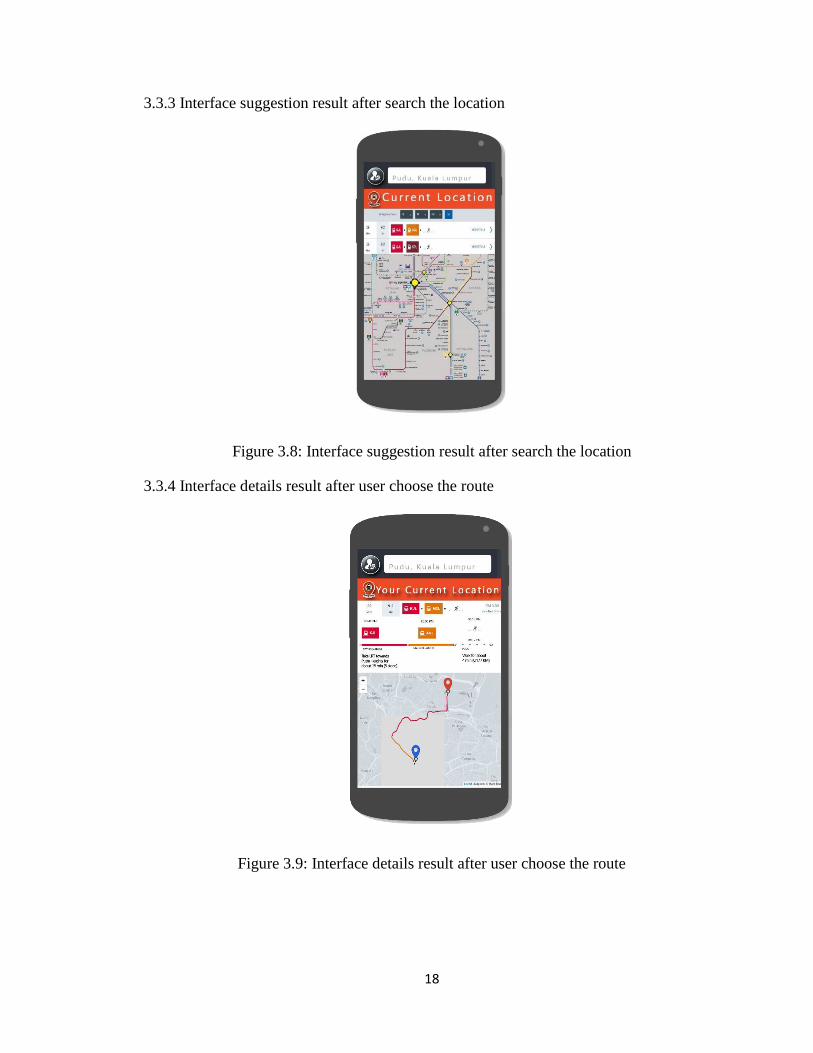
3.3.3 Interface suggestion result after search the location
Figure 3.8: Interface suggestion result after search the location
3.3.4 Interface details result after user choose the route
Figure 3.9: Interface details result after user choose the route

19
3.3.5 Interface for admin – Login
Figure 3.10: Interface for admin – Login
3.3.6 Interface for Admin – Menu to update the info
Figure 3.11: Interface for Admin – Menu to update the info

20
3.3.7 Interface for form admin update the info
Figure 3. 12: Interface for form admin update the info
UPDATE
21
3.5 METHOD / TECHNIQUES
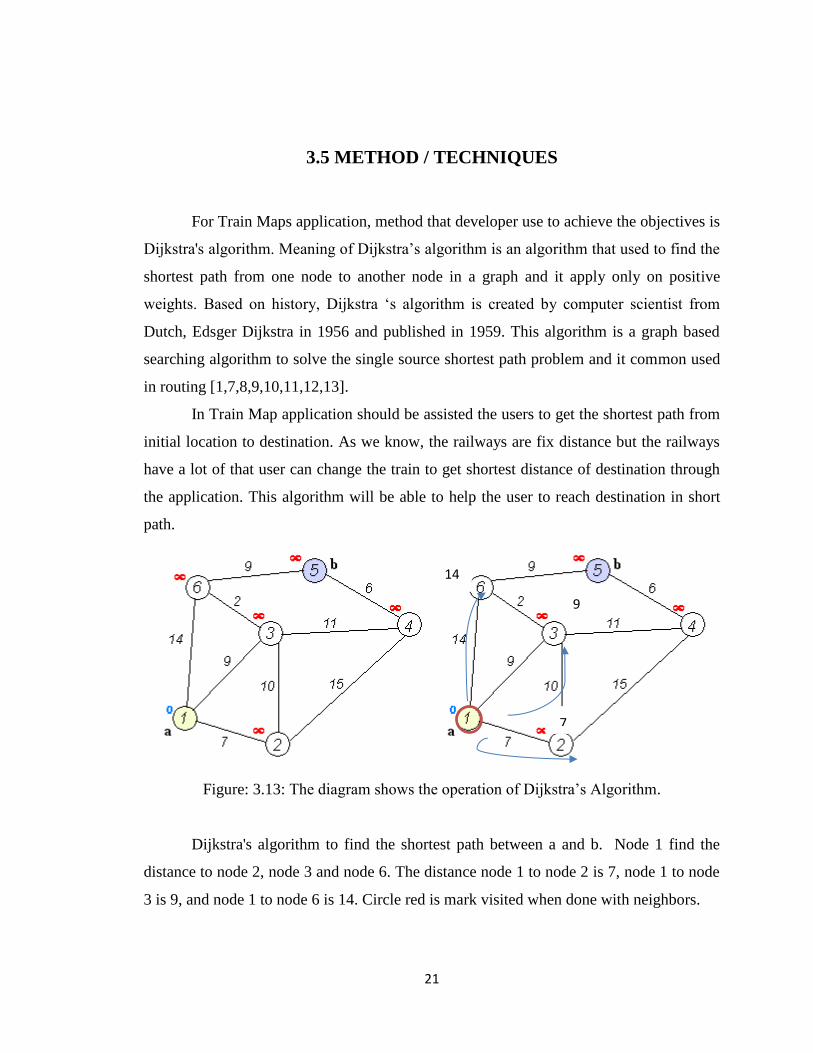
For Train Maps application, method that developer use to achieve the objectives is
Dijkstra's algorithm. Meaning of Dijkstra’s algorithm is an algorithm that used to find the
shortest path from one node to another node in a graph and it apply only on positive
weights. Based on history, Dijkstra ‘s algorithm is created by computer scientist from
Dutch, Edsger Dijkstra in 1956 and published in 1959. This algorithm is a graph based
searching algorithm to solve the single source shortest path problem and it common used
in routing [1,7,8,9,10,11,12,13].
In Train Map application should be assisted the users to get the shortest path from
initial location to destination. As we know, the railways are fix distance but the railways
have a lot of that user can change the train to get shortest distance of destination through
the application. This algorithm will be able to help the user to reach destination in short
path.
Figure: 3.13: The diagram shows the operation of Dijkstra’s Algorithm.
Dijkstra's algorithm to find the shortest path between a and b. Node 1 find the
distance to node 2, node 3 and node 6. The distance node 1 to node 2 is 7, node 1 to node
3 is 9, and node 1 to node 6 is 14. Circle red is mark visited when done with neighbors.
7
14
9

22
Figure: 3.14: The diagram shows the operation of Dijkstra’s Algorithm.
Next, comparison between node 2 reach at point b and node 3 at reach point. The
shortest distance will be chosen and update the lowest distance to node visited.
Figure: 3.15: The diagram shows the operation of Dijkstra’s Algorithm.
The result of shortest path from pint a to point b is node 1,3,6,5 (20) < node
1,3,4,5 (26).
14
9
7
11
11
9
7
7
9
22
20
20
20

23
REFERENCES
1. Pooja Singal, R.S.Chhillar (2014). Dijkstra Shortest Path Algorithm using
Global Positioning System. International Journal of Computer Applications.
2. Syahriah Bachok, Mariana Mohamed Osman, Ummi Aqilah Khalid, Mansor
Ibrahim (2013). Commuters’ Perception on Rail Based Public Transport
Services: A Case Study of KTM Komuter in Kuala Lumpur City, Malaysia.
Journal of the Malaysian Institute of Planners
3. Todd M. HUNTIMER, Coleen LIEBSCH (2014). Train Detection Systems &
Methods. Google patent, US 9227642 B2.
4. Roger D. Burns, Susan Elliott-Bryan, David B. Turner (1992). Rail Vehicle
Positioning System. United States Patent, 5,129,605.
5. K. Siva Rama Krishna, K. Veerraju Chowdary (2014). GPS/GSM Based Train
Tracking System – Utilizing Mobile Networks To Support Public
Transportation. International Journal Of Innovative Research & Development.
6. David López, Angélica Lozano (2014). Techniques in Multimodal Shortest
Path in Public Transport Systems. Transportation Research Procedia.
7. Mariusz Dramski (2012). A comparison between Dijkstra algorithm and
simplified ant colony optimization in navigation. Scientific Journals Maritime
University of Szczecin.
8. Xiao Cui and Hao Shi (2011). A*-based Pathfinding in Modern Computer
Games. IJCSNS International Journal of Computer Science and Network
Security.
9. Proof for Dijkstra’s Algorithm. Retrieve from
web.cs.ucdavis.edu/~amenta/w10/dijkstra.pdf.
10. Yizhen Huang, Qingming Yi, Min Shi (2013). An Improved Dijkstra Shortest
Path Algorithm. Proceedings of the 2nd International Conference on Computer
Science and Electronics Engineering.
11. Harika Reddy (2013). PATH FINDING - Dijkstra’s and A* Algorithm’s.
12. Yi-zhou Chen*, Shi-fei Shen, Tao Chen, Rui Yang* (2014). Path Optimization
Study for Vehicles Evacuation Based on Dijkstra algorithm. Elsevier Ltd.
24
13. Amani Saleh Alija (2015). Analysis of Dijkstra’s and A* Algorithm to Find the
Shortest Path.