traffic diversion plan for i-84 and routes 7 and 8 diversion plan for i-84 ... figure 3: map legend...
TRANSCRIPT
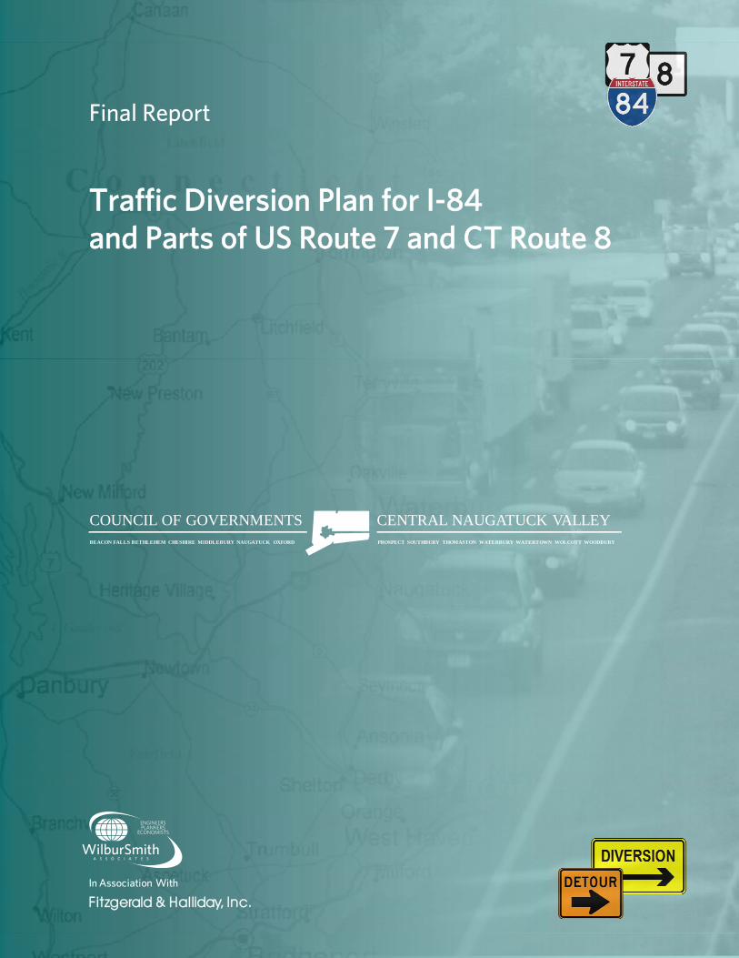
Final ReportFinal Report
Traffic Diversion Plan for I-84 and Parts of US Route 7 and CT Route 8and Parts of US Route 7 and CT Route 8
COUNCIL OF GOVERNMENTS CENTRAL NAUGATUCK VALLEYBEACON FALLS BETHLEHEM CHESHIRE MIDDLEBURY NAUGATUCK OXFORD PROSPECT SOUTHBURY THOMASTON WATERBURY WATERTOWN WOLCOTT WOODBURY
DIVERSIONIn Association With
Fitzgerald & Halliday, Inc.
Final Reportp
Traffic Diversion Plan for I-84 d P t f US R t 7 d CT R t 8and Parts of US Route 7 and CT Route 8
Prepared For
COUNCIL OF GOVERNMENTS CENTRAL NAUGATUCK VALLEYBEACON FALLS BETHLEHEM CHESHIRE MIDDLEBURY NAUGATUCK OXFORD PROSPECT SOUTHBURY THOMASTON WATERBURY WATERTOWN WOLCOTT WOODBURY
Connecticut Department of Emergency Managementand Homeland Security - Region 5
Funded By
Prepared By
In Association With
Fitzgerald & Halliday, Inc.
January 2011

January 11, 2011 TRAFFIC DIVERSION PLAN FOR I-84 AND ROUTES 7 AND 8
Wilbur Smith Associates i Council of Governments of the Central Naugatuck Valley
TABLE OF CONTENTS
1. INTRODUCTION ....................................................................................................................... 1
1.1. Study Team .......................................................................................................................... 1
1.2. Study Area ............................................................................................................................ 2
2. STAKEHOLDER OUTREACH PROCESS ....................................................................................... 3
2.1. Technical Advisory Committee ............................................................................................ 3
2.2. Stakeholder Outreach .......................................................................................................... 4
3. DATA COLLECTION ................................................................................................................... 6
4. DIVERSION ROUTE MAPS......................................................................................................... 7
4.1. Preliminary Diversion Maps ................................................................................................. 7
4.1.1. Exit to Exit Diversion Maps ............................................................................................... 9
4.1.2. Regional Diversion Maps ................................................................................................ 10
4.2. Field Verification ................................................................................................................ 11
4.3. Final Diversion Maps .......................................................................................................... 11
5. IMPLEMENTATION GUIDELINES ............................................................................................ 12
5.1. Roles and Responsibilities .................................................................................................. 12
5.1.1. Incident Commander ...................................................................................................... 13
5.1.2. State Police ..................................................................................................................... 15
5.1.3. Connecticut Department of Transportation .................................................................. 16
5.1.4. Local Police ..................................................................................................................... 17
5.1.5. Local Department of Public Works ................................................................................ 18
5.2. Post Incident Activities ....................................................................................................... 19
5.3. Record Keeping .................................................................................................................. 19
APPENDIX A: Reference Documents ............................................................................................... A
APPENDIX B: DEMHS Regional Maps .............................................................................................. B
APPENDIX C: Stakeholder Comments ............................................................................................. C
APPENDIX D: Emergency Contact Information for Municipalities ................................................. D
January 11, 2011 TRAFFIC DIVERSION PLAN FOR I-84 AND ROUTES 7 AND 8
Wilbur Smith Associates ii Council of Governments of the Central Naugatuck Valley
LIST OF FIGURES
Figure 1: Study Area ........................................................................................................................ 2
Figure 2: Stakeholder Outreach Schedule ...................................................................................... 5
Figure 3: Map Legend ..................................................................................................................... 8
Figure 4: Exit to Exit Diversion Map ................................................................................................ 9
Figure 5: Regional Diversion Map ................................................................................................. 10
Figure 6: Chain of Command for Diversion Plan ........................................................................... 13
Figure 7: Responsibilities of Incident Commander ....................................................................... 14
Figure 8: Responsibilities of State Police ...................................................................................... 15
Figure 9: Responsibilities of CTDOT .............................................................................................. 16
Figure 10: Responsibilities of Local Police .................................................................................... 17
Figure 11: Responsibilities of Local Public Works ......................................................................... 18

January 11, 2011 TRAFFIC DIVERSION PLAN FOR I-84 AND ROUTES 7 AND 8
Wilbur Smith Associates 1 Council of Governments of the Central Naugatuck Valley
1. INTRODUCTION
The Department of Emergency Management and Homeland Security (DEMHS) Region 5, in
collaboration with the Council of Governments of the Central Naugatuck Valley (COGCNV),
Housatonic Valley Council of Elected Officials (HVCEO) and Litchfield Hills Council of
Elected Officials (LHCEO) identified the need to develop emergency diversion plans for
major expressways in DEMHS Region 5.
The primary goal of the study was to shorten response time to incidents on expressways in
DEMHS Region 5 and achieve lane clearance with the greatest speed, safety and efficiency
by having a plan in place to divert traffic to alternate routes. A key component of this effort
was to develop a plan which reflected statewide and local incident management goals in
line with the “Unified Response Manual for Highway Incidents in the State of
Connecticut” (URM) (See Appendix A).
This study is part of an ongoing effort by the DEMHS to develop statewide diversion plans
to equip and guide state and local emergency responders before, during and after
emergency situations. Similar studies to develop traffic diversion plans have been
undertaken in the past by the Connecticut Department of Transportation (CTDOT). As a
result, the state currently has diversion plans for I-95, I-91, and a portion of I-84 from Exit
34 in Plainville to the Massachusetts state line. In addition, a study to develop highway
diversion plans for the I-84 segment between Cheshire and Plainville in DEMHS Region 3 is
set to begin shortly in collaboration with the Central Connecticut Regional Planning Agency
(CCRPA) and the Capitol Region Council of Governments (CRCOG).
It is envisaged that the diversion plans developed in this study would be used in concert
with other available traffic incident management tools for quick response and clearance of
incidents on the highway system. CTDOT has traffic incident management infrastructure
such as traffic cameras, Variable Message Signs (VMS), and a Highway Advisory Radio
(HAR) system that can be employed during emergency situations. In addition, the
Connecticut Highway Assistance Monitoring Patrol (CHAMP), which is a road service patrol
operated by the CTDOT, offers emergency service to motorists along major highways in the
state.
1.1. Study Team
The COGCNV, serving as the lead agency, contracted with Wilbur Smith Associates (WSA)
as the primary consultant to undertake this study. WSA is a multi-disciplinary
transportation engineering firm with extensive experience in transportation engineering

January 11, 2011 TRAFFIC DIVERSION PLAN FOR I-84 AND ROUTES 7 AND 8
Wilbur Smith Associates 2 Council of Governments of the Central Naugatuck Valley
and planning studies. WSA subcontracted with Fitzgerald and Halliday, Inc. (FHI) to
provide public involvement services for the study.
1.2. Study Area
The study area which is shown in Figure 1 was defined as
follows:
Interstate 84 (I-84) from the New York State line to
Exit 27 in Cheshire (approximately 40 miles in
length).
US Route 7 from the beginning of the divided
highway in Danbury to the end of the divided
highway in Brookfield (approximately 10 miles in
length).
CT Route 8 from Exit 23 in Beacons Falls to the end
of the divided highway in Winchester
(approximately 38 miles in length).
The study area comprises several Connecticut towns
and passes through DEMHS Region 5 and portions of
Regions 2 and 3. A map of the various DEMHS regions is
presented in Appendix B of this report.
Figure 1: Study Area

January 11, 2011 TRAFFIC DIVERSION PLAN FOR I-84 AND ROUTES 7 AND 8
Wilbur Smith Associates 3 Council of Governments of the Central Naugatuck Valley
2. STAKEHOLDER OUTREACH PROCESS
The traffic diversion plans that were developed for this study covered 88 miles and passed
through 18 towns primarily within DEMHS Region 5. For a study of this scope and
magnitude, input from stakeholders at the regional, state and local level was of the utmost
importance. Due to the diverse backgrounds and skill sets of the stakeholders, the outreach
process required effective coordination and communication between the study team and
stakeholders in order to successfully advance the study. As a first step in this process, a
Technical Advisory Committee (TAC) was formed to help guide the study. The following
sections describe in more detail the stakeholder outreach process for the study.
2.1. Technical Advisory Committee
A Technical Advisory Committee (TAC) was formed to provide input and effectively guide
the study to achieve its stated goals. The TAC comprised representatives from the following
agencies and municipalities:
COGCNV
HVCEO
LHCEO
CTDOT
CCRPA
State Police
DEMHS Region 5, Emergency Support Function (ESF) Chairs
o ESF-1 (Transportation): Joe Perelli, COGCNV Regional Planner
o ESF-3 (Public Works): John Lawlor, Waterbury Public Works Director
o ESF-5 (Emergency Management): Paul Estefan, Danbury Emergency
Management Director
o ESF-13 (Law Enforcement): Robin Montgomery, Brookfield Police Chief
Three (3) TAC meetings were held at key milestones in the study as follows:
TAC Meeting # 1 – Kick-off meeting held on May 19, 2010.
TAC Meeting # 2 – held on September 13, 2010 to review preliminary diversion
plans.
TAC Meeting # 3 – held on November 17, 2010 to review final diversion plans and
discuss implementation guidelines.
January 11, 2011 TRAFFIC DIVERSION PLAN FOR I-84 AND ROUTES 7 AND 8
Wilbur Smith Associates 4 Council of Governments of the Central Naugatuck Valley
The input and advice provided by members of the TAC played a key role in steering the
study to a successful completion.
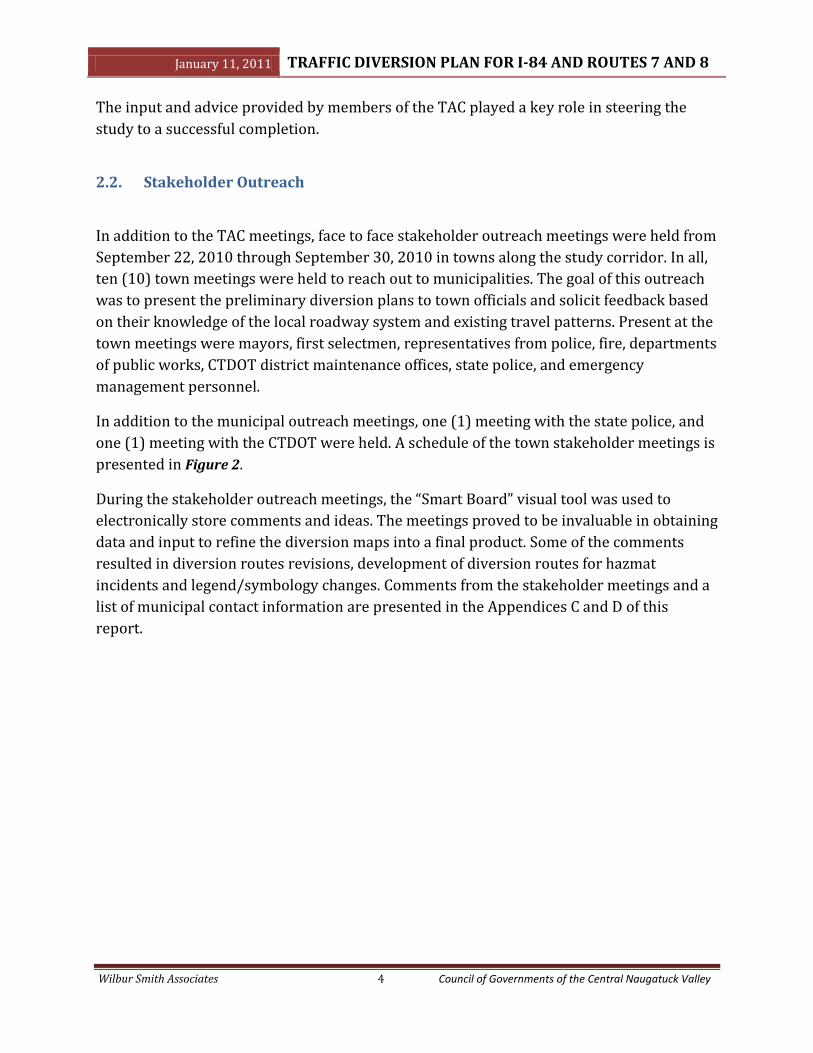
2.2. Stakeholder Outreach
In addition to the TAC meetings, face to face stakeholder outreach meetings were held from
September 22, 2010 through September 30, 2010 in towns along the study corridor. In all,
ten (10) town meetings were held to reach out to municipalities. The goal of this outreach
was to present the preliminary diversion plans to town officials and solicit feedback based
on their knowledge of the local roadway system and existing travel patterns. Present at the
town meetings were mayors, first selectmen, representatives from police, fire, departments
of public works, CTDOT district maintenance offices, state police, and emergency
management personnel.
In addition to the municipal outreach meetings, one (1) meeting with the state police, and
one (1) meeting with the CTDOT were held. A schedule of the town stakeholder meetings is
presented in Figure 2.
During the stakeholder outreach meetings, the “Smart Board” visual tool was used to
electronically store comments and ideas. The meetings proved to be invaluable in obtaining
data and input to refine the diversion maps into a final product. Some of the comments
resulted in diversion routes revisions, development of diversion routes for hazmat
incidents and legend/symbology changes. Comments from the stakeholder meetings and a
list of municipal contact information are presented in the Appendices C and D of this
report.

January 11, 2011 TRAFFIC DIVERSION PLAN FOR I-84 AND ROUTES 7 AND 8
Wilbur Smith Associates 5 Council of Governments of the Central Naugatuck Valley
Figure 2: Stakeholder Outreach Schedule
Tow
n8:
00-9
:30
am10
:30
am-1
2 no
on1:
15-2
:45
pm3:
30-5
:00
pm8:
00-9
:30
am10
:30
am-1
2 no
on1:
15-2
:45
pm3:
30-5
:00
pm10
:00
am-1
2 no
on1:
15-2
:45
pm3:
30-5
:00
pm9:
00 a
m-1
2 no
on1:
15-2
:45
pm3:
30-5
:00
pm
Danb
ury
Beth
el
New
tow
n
Broo
kfie
ld
Sout
hbur
y
Mid
dleb
ury
Wat
erbu
ry
Beac
on F
alls
Beth
any
Nau
gatu
ck
Sout
hing
ton
Ches
hire
Wat
erto
wn
Torr
ingt
on
Thom
asto
n
Harw
into
n
Litc
hfie
ld
Win
ches
ter
Wed
nesd
ay 9
/22/
2010
Tues
day
9/28
/201
0Th
ursd
ay 9
/30/
2010
Wed
nesd
ay 9
/29/
2010

January 11, 2011 TRAFFIC DIVERSION PLAN FOR I-84 AND ROUTES 7 AND 8
Wilbur Smith Associates 6 Council of Governments of the Central Naugatuck Valley
3. DATA COLLECTION
At the commencement of this study, several data items relevant to developing the diversion
plans were collected from a number of sources. It was determined earlier on by the
COGCNV that the diversion plans would be developed in Geographic Information Systems
(GIS) format. As a result, most of the data was provided to WSA in GIS format. Non-GIS data
items were digitized into GIS format. Table 1 presents a list of data items collected for the
study.
Table 1: Data Collection Items
Data Source Roadway information - Provided by COGCNV
Signalized and Un-signalized intersections - Obtained by WSA through aerial photography and field visits
Locations of existing and proposed CTDOT and municipal VMS and highway cameras
- Provided by CTDOT
Roadway plans showing: -Fire hydrants within 500 feet of limited access highways -Bridge standpipes
- Provided by COGCNV and HVCEO
Key features and emergency contact numbers for: -CTDOT maintenance facilities -state and local police stations -fire stations -hospitals/medical centers -municipal public works garages -designated emergency shelters -school locations
- Provided by CTDOT - Provided by COGCNV and municipalities - Provided by COGCNV and municipalities - Provided by COGCNV - Provided by municipalities - Provided by municipalities - Provided by COGCNV - Provided by COGCNV
Locations of rail lines and nearest railroad stations on the Metro North Line
- Provided by COGCNV
Major traffic generators in the area (for e.g. the IBM facility in Southbury) within 500ft of alternate routes
- Obtained by WSA through State Traffic Commission listings
Bridges - Provided by CTDOT
Some of the listed data items were confirmed by WSA and COGCNV through field visitations
and during the stakeholder outreach process.
January 11, 2011 TRAFFIC DIVERSION PLAN FOR I-84 AND ROUTES 7 AND 8
Wilbur Smith Associates 7 Council of Governments of the Central Naugatuck Valley
4. DIVERSION ROUTE MAPS
Diversion plans for the study area were developed in GIS using the ArcGIS 9.3 program.
Previous diversion plans for the state were developed in Computer-Aided Design (CADD),
which has its limitations with respect to map revisions and data updates. GIS based maps,
on the other hand, are interactive, allow easy data management, and provide a platform for
visual analysis of data. The sections below describe the steps that were undertaken in
developing the GIS based diversion maps.
4.1. Preliminary Diversion Maps
Two sets of preliminary diversion maps; exit-to-exit and regional were developed for I-84,
US Route 7 and CT Route 8. The plans were developed for a “Level 4” highway incident,
defined in the Unified Response Manual as any incident which would result in all travel
lanes in one or both directions being shut down for a period of two (2) or more hours. The
choice of a diversion route was based on the following criteria:
Capacity - Higher functional class roads such as US and state roads were identified
as having more capacity and were therefore given priority as diversion routes over
the lower functional class roads. Higher functional class roads were preferred in
order to minimize impacts on residential streets.
Roadway geometry - Diversion routes were checked to ensure that they met
CTDOT highway design curve radius and grade standards for both cars and trucks.
Bridge clearances - Diversion routes were assessed to ensure that all bridge
clearances along the route were 13.5 feet or higher to allow trucks to pass under
these bridges.
Movement prohibitions - One way movement and turn prohibitions were assessed
prior to the choice of a diversion route.
Size limitations for trucks - Weight restrictions on bridges along diversion routes
were checked to ensure that they could accommodate all sizes of trucks.
The diversion maps were developed with the aim of making them legible and easy to
understand by emergency personnel during an incident. As a starting point, the layout and
legend used in previous maps for CTDOT Highway Operations were adopted and revised
during the course of the study. Primary, and in some cases, secondary diversion routes
were identified based on the criteria outlined above. For the most part, the diversion
routes that were identified could accommodate both cars and trucks. However, there were
some instances where a separate truck route had to be developed due to bridge clearance
and/or roadway geometry restrictions.

January 11, 2011 TRAFFIC DIVERSION PLAN FOR I-84 AND ROUTES 7 AND 8
Wilbur Smith Associates 8 Council of Governments of the Central Naugatuck Valley
The following items were identified on the diversion maps and are illustrated in the sample
map legend presented in Figure 3.
Response plan code – This refers to the “RP” number located
on the bottom right corner of the map. This code will be used
by the incident commander/state police dispatcher to notify
the CTDOT and emergency personnel of the diversion plan to
be activated.
Highway closure locations –This is shown as a hatched area
on the map (symbol shown in “A” of Figure 3).
All vehicle diversion routes – This refers to diversion routes
to be used by both cars and trucks. It is shown as a purple line
on the map (symbol shown in “A” of Figure 3). The
corresponding arrows along these routes are filled in with
hatch marks.
Car only diversion routes – This refers to diversion routes to
be used by cars only. It is shown as a navy blue line on the
map (symbol shown in “A” of Figure 3). The corresponding
arrows along these routes are not filled in.
Figure 3: Map Legend
Truck only diversion routes – This refers to diversion routes to be used by trucks
only. It is shown as a turquoise line on the map (symbol shown in “A” of Figure 3).
The corresponding arrows along these routes are completely filled in.
Locations and number of diversion route signs – This is shown in “A” and “B” of
Figure 3.
Traffic signals – This is shown as a yellow circle on the map (symbol shown in “A” of
Figure 3).
Police monitoring at signalized intersections – These are locations where local
police will monitor traffic signals. This is shown on the map as a yellow circle in
purple background (symbol shown in “A” of Figure 3).
Police monitoring at un-signalized intersections – These are locations where local
police will monitor stop controlled intersections. This is shown on the map as a
white box (symbol shown in “A” of Figure 3).
Roadway functional classification– Roads within the study area where classified
based on the Federal Highway Administration (FHWA) roadway classification
system and illustrated with different colors and line weights on the map (symbols
shown in “A” of Figure 3).
A
B
C
D
E
January 11, 2011 TRAFFIC DIVERSION PLAN FOR I-84 AND ROUTES 7 AND 8
Wilbur Smith Associates 9 Council of Governments of the Central Naugatuck Valley
Emergency contact information for local and state agencies – This is shown in “C” of
Figure 3.
Description of diversion routes – This is shown in “D” of Figure 3.
Special requirements – This is shown in “E” of Figure 3.
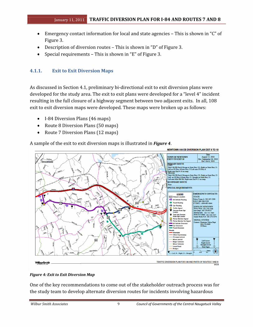
4.1.1. Exit to Exit Diversion Maps
As discussed in Section 4.1, preliminary bi-directional exit to exit diversion plans were
developed for the study area. The exit to exit plans were developed for a “level 4” incident
resulting in the full closure of a highway segment between two adjacent exits. In all, 108
exit to exit diversion maps were developed. These maps were broken up as follows:
I-84 Diversion Plans (46 maps)
Route 8 Diversion Plans (50 maps)
Route 7 Diversion Plans (12 maps)
A sample of the exit to exit diversion maps is illustrated in Figure 4.
Figure 4: Exit to Exit Diversion Map
One of the key recommendations to come out of the stakeholder outreach process was for
the study team to develop alternate diversion routes for incidents involving hazardous

January 11, 2011 TRAFFIC DIVERSION PLAN FOR I-84 AND ROUTES 7 AND 8
Wilbur Smith Associates 10 Council of Governments of the Central Naugatuck Valley
materials (hazmat) or other transportation-related disasters, particularly in the vicinity of
the I-84/Route 8 interchange in Waterbury. As a result, seven (7) diversion maps inclusive
of the 108 maps were developed for hazmat incidents at the following locations:
I-84 between Exit 19 and Exit 22 (1 map)
Route 8 between Exit 29 and Exit 34 (5 maps)
Route 7 between the Miry Brook Road Exit and Park Avenue Exit (1 map)
4.1.2. Regional Diversion Maps
Bi-directional regional diversion maps were developed for “level 4” incidents resulting in
the full closure of a highway spanning several exits. These maps were developed primarily
around some of the major towns and cities within the study area. A total of six (6) regional
diversion maps were developed for the following highway closures:
I-84 closure between Exit 3 and Exit 8 in Danbury (2 maps)
I-84 closure between Exit 8 and Exit 16 (2 maps)
I-84 closure between Exit 18 and Exit 24 in Waterbury (2 maps)
A sample of the regional diversion maps is presented below in Figure 5.
Figure 5: Regional Diversion Map

January 11, 2011 TRAFFIC DIVERSION PLAN FOR I-84 AND ROUTES 7 AND 8
Wilbur Smith Associates 11 Council of Governments of the Central Naugatuck Valley
4.2. Field Verification
In the course of developing the diversion maps, field
visits were undertaken to verify bridge and roadway
data such as bridge clearances, roadway widths, grades,
and curve radius. One such field visit was held on
October 28, 2010 with Danbury and CTDOT personnel to
discuss a railroad bridge clearance issue on West Street
in Danbury and to identify an alternate diversion route
for trucks in the area. Another field visit was undertaken
by WSA to assess grade concerns on Route 322 in
Southington. These field visits provided an opportunity to gather any additional data that
was missing from the diversion plans.
4.3. Final Diversion Maps
As discussed in Chapter 2 of this report, the preliminary diversion maps were presented to
the TAC and other stakeholders for their review and input. The feedback provided resulted
in additional fine tuning of the maps. The final version of the diversion maps was bound
into a document and provided to the COGCNV upon completion of the study.
January 11, 2011 TRAFFIC DIVERSION PLAN FOR I-84 AND ROUTES 7 AND 8
Wilbur Smith Associates 12 Council of Governments of the Central Naugatuck Valley
5. IMPLEMENTATION GUIDELINES
While it is important to have a diversion plan in place in the event of a highway incident, it
is equally important to establish a set of guidelines that would enable emergency
responders effectively execute the plan during an incident. The implementation guidelines
should be concise, unambiguous, and should foster interagency cooperation and
coordination during an emergency. Implementation guidelines were established for the
traffic diversion plans developed for the study area using the following documents as
reference:
Guidelines for Use of Traffic Diversion Plans - by CTDOT Highway Operations.
Unified Response Manual for Highway Incidents in the State of Connecticut - by the
Statewide Incident Management Task Force.
These two (2) documents are presented in the Appendix A of this report. Some of the key
issues addressed in the implementation guidelines are when to initiate a diversion plan, the
notification process, roles and responsibilities of emergency responders, and post incident
activities.
5.1. Roles and Responsibilities
When roles and responsibilities are not clearly spelled out in high pressure situations, it
frequently leads to confusion, lack of communication and coordination, and ultimately
results in a poorly executed plan. A key consideration in developing the implementation
guidelines was, therefore, to clearly identify the roles and responsibilities of emergency
responders.
The URM identifies a wide array of roles and responsibilities for all emergency responders
during an incident. For the purposes of this study, these roles were streamlined and
tailored specifically to the implementation of a diversion plan. Furthermore, the roles and
responsibilities are presented in a simple flow chart that can be easily understood. Figure 6
illustrates the chain of command during the implementation of an emergency diversion
plan.
January 11, 2011 TRAFFIC DIVERSION PLAN FOR I-84 AND ROUTES 7 AND 8
Wilbur Smith Associates 13 Council of Governments of the Central Naugatuck Valley
Figure 6: Chain of Command for Diversion Plan
The sections below describe in more detail, the roles and responsibilities of emergency
responders prior to and during the implementation of a diversion plan.
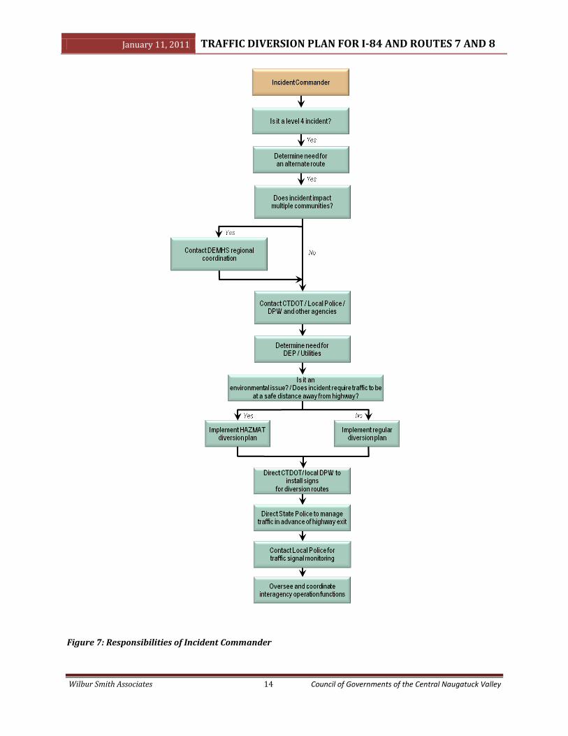
5.1.1. Incident Commander
The role of incident commander is generally assumed by the first emergency responder to
arrive on the scene until the arrival of the fire chief. Once on the scene, the fire chief
assumes this role (CT General Statute Section 7-313e). The incident commander will be
responsible for assessing whether an incident is a “level 4” incident, in which case a
diversion plan should be initiated. If a diversion plan is to be implemented, the incident
commander will notify CTDOT Highway Operations, the DEMHS regional coordinator, local
police and other agencies through the appropriate response plan code. This response code
is noted on the lower right corner of the diversion maps (RP number). During the execution
of a diversion plan, the incident commander will oversee all activities and coordinate all
inter-agency functions. Figure 7 outlines key responsibilities of the incident commander.
January 11, 2011 TRAFFIC DIVERSION PLAN FOR I-84 AND ROUTES 7 AND 8
Wilbur Smith Associates 14 Council of Governments of the Central Naugatuck Valley
Figure 7: Responsibilities of Incident Commander
January 11, 2011 TRAFFIC DIVERSION PLAN FOR I-84 AND ROUTES 7 AND 8
Wilbur Smith Associates 15 Council of Governments of the Central Naugatuck Valley
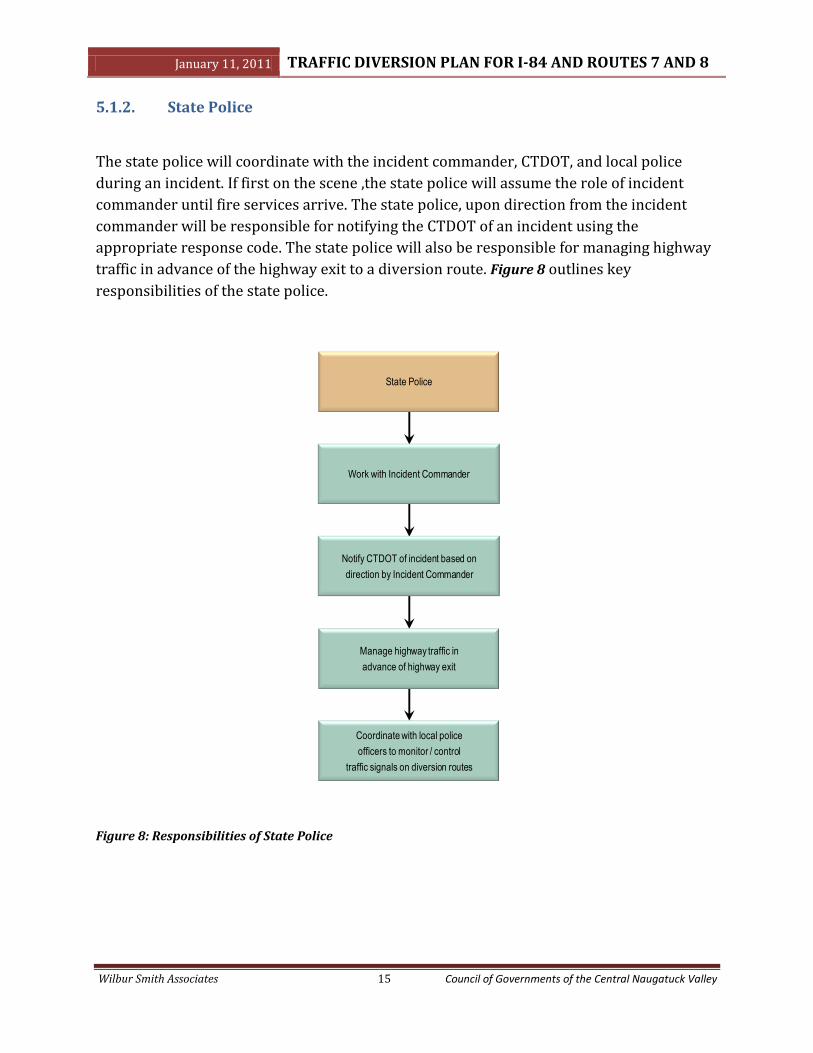
5.1.2. State Police
The state police will coordinate with the incident commander, CTDOT, and local police
during an incident. If first on the scene ,the state police will assume the role of incident
commander until fire services arrive. The state police, upon direction from the incident
commander will be responsible for notifying the CTDOT of an incident using the
appropriate response code. The state police will also be responsible for managing highway
traffic in advance of the highway exit to a diversion route. Figure 8 outlines key
responsibilities of the state police.
Figure 8: Responsibilities of State Police
Coordinate with local police
officers to monitor / control
traffic signals on diversion routes
Work with Incident Commander
Manage highway traffic in
advance of highway exit
State Police
Notify CTDOT of incident based on
direction by Incident Commander

January 11, 2011 TRAFFIC DIVERSION PLAN FOR I-84 AND ROUTES 7 AND 8
Wilbur Smith Associates 16 Council of Governments of the Central Naugatuck Valley
5.1.3. Connecticut Department of Transportation
CTDOT will coordinate with the incident commander, state police, Department of
Environmental Protection (DEP), and local agencies during an incident. CTDOT personnel
will be responsible for activating the diversion plan based on direction from the incident
commander or state police. The CTDOT will also be responsible for activating ITS devices
such as VMS, HARs, CHAMP, signal timings, and setting up detour signs. Key responsibilites
of the CTDOT are outlined in Figure 9 below.
Figure 9: Responsibilities of CTDOT

January 11, 2011 TRAFFIC DIVERSION PLAN FOR I-84 AND ROUTES 7 AND 8
Wilbur Smith Associates 17 Council of Governments of the Central Naugatuck Valley
5.1.4. Local Police
The local police will be available to work with the incident commander and assist other
agencies as needed. Local police will be responsible for traffic signal monitoring, directing
local traffic from diversion routes and assisting with the installation of directional signs as
needed. These responsibilites are presented below in Figure 10.
Figure 10: Responsibilities of Local Police
Assist CTDOT / DPW to installsigns along detour route
Work with Incident Commander / State Police
Direct local traffic away fromdiversion route
Work with CTDOT for diversionsigning and implementation
Local Police
Setup officers to monitor / control traffic signals on diversion plan

January 11, 2011 TRAFFIC DIVERSION PLAN FOR I-84 AND ROUTES 7 AND 8
Wilbur Smith Associates 18 Council of Governments of the Central Naugatuck Valley
5.1.5. Local Department of Public Works
The local Department of Public Works (DPW) will be available to work with the incident
commander and assist other agencies as needed. The responsibilites of the DPW will
mainly involve working with CTDOT and local police to install signs and direct traffic. Key
responsibilities of the DPW are presented below in Figure 11.
Figure 11: Responsibilities of Local Public Works
Contact local Police for assistance to install signs along detour routes and if
necessary on diversion plan routes
Assist local Police formanaging and directing traffic
Direct local traffic away fromdiversion route if necessary with
Police Department
Work with CTDOT for diversionsigns and implementation
Local Department of Public Works
(DPW)
Implement specific traffic signaltimings along key local routes to
manage traffic flow
Remove all temporary traffic signs after incident

January 11, 2011 TRAFFIC DIVERSION PLAN FOR I-84 AND ROUTES 7 AND 8
Wilbur Smith Associates 19 Council of Governments of the Central Naugatuck Valley
5.2. Post Incident Activities
Once an incident has been cleared, there are a number of post incident activities that can be
undertaken to address issues arising during the execution of a plan and also to identify
ways of improving the diversion plan for future incidents. The post incident activities
outlined in this section are based on the URM and are as follows:
Post Incident Debriefing – A post incident debriefing should be held immediately
after an incident is cleared. The Unified Response Manual recommends that the
meeting be held away from the scene of the incident to avoid any additional delays
or incidents. The atmosphere of the debriefing should be positive and without finger
pointing. The goal of the meeting would be to discuss issues and concerns arising
during the execution of a diversion plan and to identify any necessary
improvements for future incidents.
After Action Reports – Agencies should consider “after action” reports assessing
their individual response during an incident. The findings from these reports could
be made available to the DEMHS regional coordinator and other agencies such as
Regional Planning Organizations (RPOs).
Multi-Agency Periodic Meetings/Training – It is recommended that periodic multi-
agency meetings/training sessions be held to foster inter-agency communication
and coordination. Routine drills could be held during these meetings/training
sessions to prepare and equip emergency responders for real world incidents.
5.3. Record Keeping
It is envisaged that the traffic diversion maps would have to be updated periodically to
reflect changes in the field as well as any contact information changes. It is therefore
important to have a good record keeping system to allow for quick and easy updates.
CTDOT will host the final version of the diversion maps in PDF format and make them
available on the Department's webpage. Requests to revise these maps would be made as
needed by the DEMHS 5 Regional Emergency Planning Team (REPT) Steering
Committee. The REPT will rely upon regional planning organizations in the DEMHS
5 region for technical assistance in making map changes.
January 11, 2011 TRAFFIC DIVERSION PLAN FOR I-84 AND ROUTES 7 AND 8
Wilbur Smith Associates 20 Council of Governments of the Central Naugatuck Valley
This process would insure coordination within the emergency management community
and avoid any confusion caused by the potential creation of varying official versions. Upon
return to CTDOT, changes would be subject to approval by CTDOT
January 11, 2011 TRAFFIC DIVERSION PLAN FOR I-84 AND ROUTES 7 AND 8
Wilbur Smith Associates A Council of Governments of the Central Naugatuck Valley
APPENDIX A: Reference Documents

Unified Response Manual for Highway Incidents
in the State of Connecticut
Version 1.1
September 2, 2008

Unified Response Manual for Highway Incidents in the State of Connecticut

Unified Response Manual for Highway Incidents in the State of Connecticut
- i - June 2008
Table of Contents 1 Introduction .............................................................................................................. 1
1.1 Purpose .......................................................................................................................................................... 1
1.2 Overview ......................................................................................................................................................... 1
1.3 Intended Use .................................................................................................................................................. 1
1.4 Coordination .................................................................................................................................................. 1
1.5 Incident Command......................................................................................................................................... 2
1.6 Incident Classification ................................................................................................................................... 3
2 Operational Considerations .................................................................................... 9 2.1 Initial Approach .............................................................................................................................................. 9
2.1.1 Personal Safety ................................................................................................................................. 9
2.1.2 Incident Size-Up ................................................................................................................................ 9
2.1.3 Personal Injury/Fatality .................................................................................................................... 10
2.1.4 Potential Crime Scene ..................................................................................................................... 10
2.2 Emergency Management Actions .............................................................................................................. 10
2.3 Recovery Actions ........................................................................................................................................ 11
3 Agency Actions ...................................................................................................... 12 3.1 Law Enforcement ......................................................................................................................................... 12
3.1.1 First on the Scene ........................................................................................................................... 12
3.1.2 Joining an Established Command ................................................................................................... 12
3.1.3 Incident Management Actions ......................................................................................................... 12
3.2 Fire and Rescue ........................................................................................................................................... 13
3.2.1 First on the Scene ........................................................................................................................... 13
3.2.2 Joining an Established Command ................................................................................................... 13
3.2.3 Incident Management Actions ......................................................................................................... 13
3.3 Emergency Medical Service ........................................................................................................................ 14
3.3.1 First on the Scene ........................................................................................................................... 14
3.3.2 Joining an Established Command ................................................................................................... 14
3.3.3 Incident Management Actions ......................................................................................................... 14
3.4 Traffic Control/Transportation .................................................................................................................... 15
3.4.1 First on the Scene ........................................................................................................................... 15
3.4.2 Joining an Established Command ................................................................................................... 15
3.4.3 Incident Management Actions ......................................................................................................... 15
3.5 Towing and Recovery .................................................................................................................................. 16
3.6 Environmental Protection ........................................................................................................................... 17
3.7 Medical Examiner ........................................................................................................................................ 18
4 Post-Incident Considerations ............................................................................... 19 5 Summary of Duties and Responsibilities ............................................................ 20

Unified Response Manual for Highway Incidents in the State of Connecticut
- ii - June 2008
List of Appendices
Appendix A: Acronyms …………………………………………………………………………………………. 22
Appendix B: Typical Incident Command System ………………………………………………………….. 23
Appendix C: Applicable State Statutes ………………………………...……………………………………. 24
Appendix D: Connecticut Highway Incident Management Policy ………………………………………. 25
Appendix E: Connecticut Quick Clear Policy ………………………………………………..…………….. 28
Appendix F: Temporary Traffic Control Devices ………………………………..………………………… 30
Appendix G: HAZMAT Recognition Check List ……………………………………...………..…………… 32
Appendix H: Establishing Control Zone & Vehicle Positioning On Scene ……………………………. 33
Appendix I: T.R.A.A. Vehicle Towing Guide ………………………..………………………………………. 35
Appendix J: DOT Highway Operations Diversion Route Plans ………………………..……………….. 38
Appendix K: After Action Reviews……………………………………………………………………………. 39
Appendix L: Contact Information …………………………………………………..………………………… 43
NOTES……………………………………………………………………………………………………………… 45
Unified Response Manual for Highway Incidents in the State of Connecticut
- 1 - June 2008
1. Introduction
1 INTRODUCTION
1.1 Purpose This manual serves as a field reference to enhance interagency coordination of first responders at traffic incident scenes on limited-access highways in the State of Connecticut. This manual suggests guidelines that do not replace, but rather enhance existing policies and procedures.
1.2 Overview This manual focuses on unified response to highway incidents on limited-access highways in the State of Connecticut. It serves as a reminder of the available resources and interagency collaboration considerations. It is intended to reduce confusion, reduce potential conflicts, and facilitate communication among agencies responding to incidents.
This manual is designed to provide general operational considerations, specific agency-related actions, general post-incident considerations, and resource information, as shown in the appendices. The appendices include: a list of acronyms; a NIMS-compliant, typical Incident Management System (IMS) structure; useful contact information; a guide to temporary traffic control devices; and the T.R.A.A. Vehicle Towing Guide1.
1.3 Intended Use This manual is intended to support the incident management goals of improving the safety of incident responders, reducing the potential of secondary incidents, and reducing congestion delay on the transportation system. Please note:
• This manual is not a substitute for agency-specific training classes and manuals, but is intended to supplement incident responders’ appropriate prior training and experience.
• This manual summarizes useful incident management principles and considerations.
• This manual does not recommend a one-size-fits-all approach to incident response and management. Each incident must be assessed with careful regard given to its unique characteristics and hazards.
• This manual serves as a reminder of available resources and terminology. • The manual is intended to evolve and be revised to reflect advances in incident management techniques,
technologies, and agency policies and procedures. • This manual is consistent with the National Incident Management System’s Command and Management
component, but does not focus on other NIMS components, such as Preparedness, Resource Management, Communications and Information Management, Supporting Technology, and Ongoing Management and Maintenance.
1.4 Coordination Effective and efficient incident management requires multi-agency coordination beyond the scope of this manual. Proper multi-agency coordination requires that:
• Incident response agencies should meet together periodically to discuss capabilities and limitations.
• Incident response agencies should meet together periodically to pre-plan typical equipment staging, response routes, and practices.
• Incident response agencies should meet together periodically to review and update diversion route plans2.
• Each Incident response agency should conduct incident response and management training and participate in cross-training with other responding agencies.
• Incident management stakeholders should periodically review and update this manual and other incident management materials and documentation.
1 Used with permission from T.R.A.A. 2 Refer to Appendix J for a list of existing DOT diversion route plans.

Unified Response Manual for Highway Incidents in the State of Connecticut
- 2 - June 2008
1. Introduction
• Incident response agencies may enlist the assistance of RPAs/COGs in distributing incident management materials and information to emergency responders throughout the state.
1.5 Incident Command The Incident Command System (ICS) is a widely-recognized approach to incident management. ICS establishes a unified organizational structure to coordinate interagency response efforts that is consistent with NIMS. ICS is scalable in response to escalating incident hazards. In incidents involving multiple jurisdictions or multi-agency involvement, Unified Command (UC), an application of ICS, is used to allow for a single, collaborative management approach. Unified Command is based on shared authority that changes commanders as an incident progresses through different phases. A typical incident command system is presented in Appendix B.
Under current Connecticut statutes3, the following considerations govern incident command:
• The first responder to arrive on scene assumes incident command until a specialized agency arrives. For highway incidents, State Police are typically the first on the scene, and the highest-ranking officer assumes incident command.
• The highest ranking State Police officer retains incident command unless a fire service is responding or on scene. In that event, the fire chief or fire officer-in-charge assumes incident command with physical transfer of command occurring once the fire service arrives on scene. Following the completion of the fire suppression and rescue operations phases, incident command is typically transferred back to the highest ranking State Police officer at the scene.
• Depending on the incident, other agencies may also assume incident command for various phases (e.g., DEP for the hazardous material identification, mitigation, and containment phases or the military for a weapons spill containment phase). Following the completion of these phases, incident command is then typically transferred back to the highest ranking State Police officer at the scene.
• Incident responders must continually re-assess the incident to ensure that the ICS is being utilized properly in response to changing incident conditions and hazards.
An Incident Commander is responsible for not only managing conditions at the scene, but also for managing conditions along the resulting queue. Incident Commanders should also:
• Explicitly establish and transfer command, as necessary.
• Establish overarching objectives consistent with the multiple goals of effective incident management (ensuring the safety of incident responders, reducing the potential of secondary incidents, and reducing congestion delay.)
• The incident commander must establish a lane closure pattern in coordination with other agencies as part of the initial actions. All initial responders must be advised by radio and other means how and where to park to conform to the lane closure plan. Lead representatives from each agency must advise all additional responders including mutual aid how/where to park in conformance with this lane closure plan. See Appendix H for additional information and guidance.
• Develop and issue assignments.
• Establish specific, measurable objectives for various incident management functional activities and direct efforts to attain established objectives.
• Effectively communicate information regarding the unique hazards and characteristics of the incident to dispatch and fellow responders.
• Document results.
As part of a Unified Command, designated agency representatives should jointly determine objectives, strategies, plans, and priorities and work together to execute integrated incident operations and maximize the use of assigned resources. Communications among responders should be managed in accordance with the incident command system4.
3 CT General Statute Section 7-313e. Refer to Appendix C. 4 Refer to Appendix B.

Unified Response Manual for Highway Incidents in the State of Connecticut
- 3 - June 2008
1. Introduction
1.6 Incident Classification5 The following incident classification scheme is proposed for quickly communicating an incident’s scope and severity. This classification does not in any way replace the need for detailed communication of each incident’s unique characteristics and hazards. Typically incident classification would occur as part of the initial approach of the first responder to arrive on scene and then periodically re-evaluated by the Incident Commander throughout the duration of the incident.
• Level 1 Incidents: These are minor incidents involving only property damage and not requiring fire and rescue services. At least one traffic lane in each direction must remain unobstructed.
• Level 2 Incidents: The most common type of incident, Level 2 Incidents involve personal injuries and/or fire and rescue activities. For Level 2 Incidents, at least one traffic lane in each direction must remain unobstructed and all spills, if any, can be contained by the responding fire and rescue agencies.
o Level 2 Haz Mat: spills can be contained by the responding fire and rescue agencies but does not require Environmental Clean Up. 1-3 hours for incident mitigation.
• Level 3 Incidents: Level 3 Incidents may also involve personal injuries and fire and rescue activities. However, for Level 3 Incidents, 2 or more traffic lanes in one direction are obstructed, and at least one traffic lane is open in both directions, and/or there are spills requiring specialized containment/cleanup.
o Level 3.1 HazMat: Minor release <25 gallons, contained, requires Vac Truck for removal (possibly into a Catch Basin), petroleum (diesel fuel, or Passenger Vehicle Gasoline) 1-3 hours for incident mitigation.
o Level 3.2 HazMat: Same as above, but spill is larger (>25 gals, 1 or more saddle/fuel tanks) affects shoulder or median and requires excavation equipment. 2-6 hours for incident mitigation.
• Level 4 Incidents: Level 4 Incidents involve any of the following:
o A fatality.
o All traffic lanes in one or both directions are obstructed.
o The presence of HAZMAT or CBRNE indicators.
o Level 4.1 HazMat: Incident involves a commercial bulk petroleum vehicle that may or may not need to be off-loaded. 4-8 hours for incident stabilization.
o Level 4.2 HazMat: Incident involves Commercial Bulk or non-bulk Vehicle (i.e. – tanker or box truck with mixed load of Hazardous Materials) with potential or actual release/chemical reaction. 4-8 hours for incident stabilization
o Level 4.3 HazMat: Incident involves Commercial Bulk or non-Bulk Vehicle with actual chemical release/chemical reaction. 8+ hours for incident stabilization
o Suspicion of terrorism or an ongoing criminal act.
o Significant damage to or the collapse of a major transportation infrastructure component.
o Military weapon spills.
5 Most of this section has been adapted from the Massachusetts Highway Department’s Unified Response Manual for Roadway Traffic Incidents, July 1998.

Unified Response Manual for Highway Incidents in the State of Connecticut
- 4 - June 2008
1. Introduction
INCIDENT LEVEL MATRIX
Criteria Traffic Level
1 2 3 4
Debris or disablement X
Injuries X X X
Fatality X
Hazmat: Spill requiring special cleanup or containment
X X
CBRNE, suspicion of terrorism or ongoing criminal act, significant damage to major transportation infrastructure, or military weapons spill
X
1 or more lanes blocked; at least 1 lane open in both directions
X
2 or more lanes blocked; at least 1 lane open in both directions
X
All lanes blocked, in either 1 or both Directions
X
Minimum duration 30 Minutes 1 Hr 1 + Hrs 2 + Hrs
Table 1: Incident Level Matrix
Table 1 depicts the criteria used to define each incident level. For example, a 2-car accident, blocking 2 travel lanes, personal injury, a duration of an hour with a little radiator fluid and gas would be a Level 3 incident.
Unified Response Manual for Highway Incidents in the State of Connecticut
- 5 - June 2008
1. Introduction
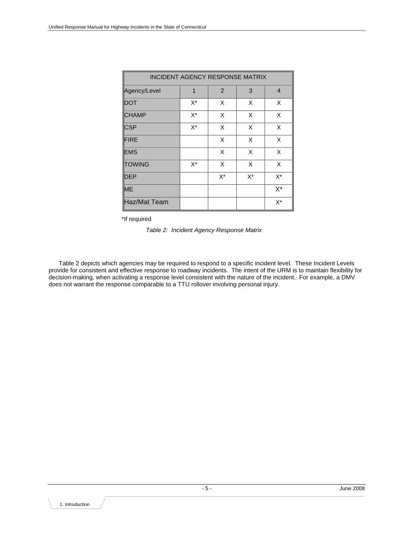
INCIDENT AGENCY RESPONSE MATRIX
Agency/Level 1 2 3 4
DOT X* X X X
CHAMP X* X X X
CSP X* X X X
FIRE X X X
EMS X X X
TOWING X* X X X
DEP X* X* X*
ME X*
Haz/Mat Team X*
*If required
Table 2: Incident Agency Response Matrix
Table 2 depicts which agencies may be required to respond to a specific incident level. These Incident Levels provide for consistent and effective response to roadway incidents. The intent of the URM is to maintain flexibility for decision-making, when activating a response level consistent with the nature of the incident. For example, a DMV does not warrant the response comparable to a TTU rollover involving personal injury.
Unified Response Manual for Highway Incidents in the State of Connecticut
- 6 - June 2008
1. Introduction
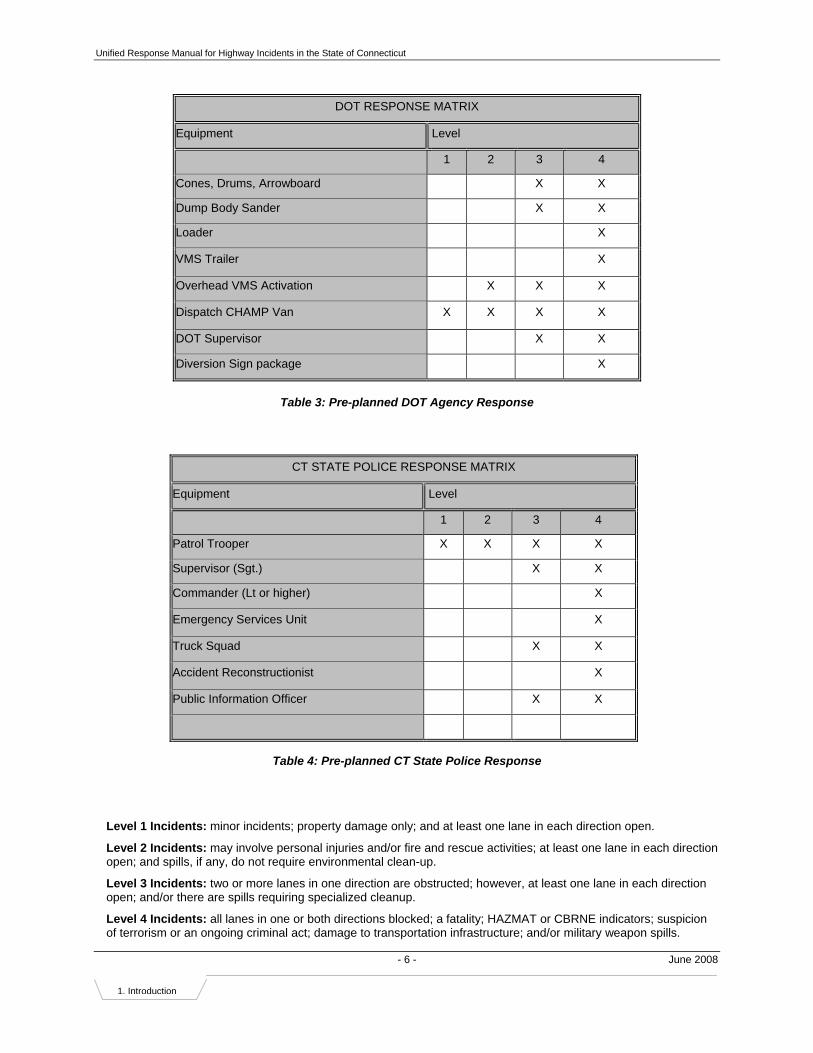
Table 3: Pre-planned DOT Agency Response
Table 4: Pre-planned CT State Police Response
Level 1 Incidents: minor incidents; property damage only; and at least one lane in each direction open.
Level 2 Incidents: may involve personal injuries and/or fire and rescue activities; at least one lane in each direction open; and spills, if any, do not require environmental clean-up.
Level 3 Incidents: two or more lanes in one direction are obstructed; however, at least one lane in each direction open; and/or there are spills requiring specialized cleanup.
Level 4 Incidents: all lanes in one or both directions blocked; a fatality; HAZMAT or CBRNE indicators; suspicion of terrorism or an ongoing criminal act; damage to transportation infrastructure; and/or military weapon spills.
DOT RESPONSE MATRIX
Equipment Level
1 2 3 4
Cones, Drums, Arrowboard X X
Dump Body Sander X X
Loader X
VMS Trailer X
Overhead VMS Activation X X X
Dispatch CHAMP Van X X X X
DOT Supervisor X X
Diversion Sign package X
CT STATE POLICE RESPONSE MATRIX
Equipment Level
1 2 3 4
Patrol Trooper X X X X
Supervisor (Sgt.) X X
Commander (Lt or higher) X
Emergency Services Unit X
Truck Squad X X
Accident Reconstructionist X
Public Information Officer X X

Unified Response Manual for Highway Incidents in the State of Connecticut
- 7 - June 2008
1. Introduction
Table 5: Pre-planned Fire Department Response
Level 1 Incidents: minor incidents; property damage only; and at least one lane in each direction open.
Level 2 Incidents: may involve personal injuries and/or fire and rescue activities; at least one lane in each direction open; and spills, if any, do not require environmental clean-up.
Level 3 Incidents: two or more lanes in one direction are obstructed; however, at least one lane in each direction open; and/or there are spills requiring specialized cleanup.
Level 4 Incidents: all lanes in one or both directions blocked; a fatality; HAZMAT or CBRNE indicators; suspicion of terrorism or an ongoing criminal act; damage to transportation infrastructure; and/or military weapon spills.
FIRE DEPARTMENT RESPONSE MATRIX
Equipment Level
1 2 3 4
Command Car X X X
Fire Pumper(s) X X X
Rescue Truck(s) X* X X
Haz Mat Truck X* X*
Decon Trailer/Specialized Equipment X*

Unified Response Manual for Highway Incidents in the State of Connecticut
- 8 - June 2008
1. Introduction
Table 6: Pre-planned CT DEP Agency Response
Notes:
* Only if needed
ERC = Emergency Response Coordinator (minimum two ERC respond to an incident)
DEP Responders come in individually equipped vehicles
Equipment as noted above is provided by CT DEP Contractor Resources
Level 2 – contained by local fire department, does not requires environmental clean up
Level 3.1 – <25 gallons, requires vac truck for fuel removal / clean up
Level 3.2 – >25 gallons, requires soil excavation along highway
Level 4.1 – Commercial Bulk petroleum vehicle that may or may not need to be emptied
Level 4.2 – Commercial Bulk or non-Bulk vehicle with potential chemical release / reaction
Level 4.3 – Commercial Bulk or non-Bulk vehicle with chemical release/reaction
DEP RESPONSE MATRIX
Responders Level
2 3.1 3.2 4.1 4.2 4.3
DEP ERC (2) X* X X X X X
DEP ERC (2) X X X X
DEP ERC (2) X
Equipment
Spill Van X* X X X X X
Foreman X* X X X X X
Vac Truck X X X X X
Roll Off X X X X
Excavator X X
ER Van X X X
Supervisor X X

Unified Response Manual for Highway Incidents in the State of Connecticut
- 9 - June 2008
2. Operational Considerations
2 OPERATIONAL CONSIDERATIONS
2.1 Initial Approach
2.1.1 Personal Safety • Confirm the exact location of the incident and communicate incident location to dispatcher or home office
as accurately as possible. Please take advantage of mile markers to aid in this effort.
• Observe traffic volume and speed.
• Observe conditions of the road surface (to ensure adequate protection zone according to safe traffic stopping distance requirements).
• Observe number of traffic lanes blocked.
• Evaluate and implement personal protective measures, including whether or not protective gear is warranted, according to your agency’s standard operating procedures.
• Establish control zone to protect personnel while allowing traffic flow around the incident, if possible.6
o Remember to set up the control zone in accordance with the Manual on Uniform Traffic Control Devices (MUTCD)7. Be sure to provide an adequate advance warning zone, transition zone, and buffer zone based on road geometrics, weather conditions, and visibility.
o Consider emergency equipment placement without unnecessarily impeding traffic flow.
o Consideration should be given to carrying a minimum of 6-8 traffic cones on responding vehicles, especially those that are likely to be first or among the first to respond to the scene of an incident.
o Use arrow boards, such as those provided on CHAMP vehicles, if available.
o Consider detouring traffic around the incident by giving directions to motorists.
o Coordinate with DOT to formally establish a control zone and traffic control at the incident site, based on number of lanes obstructed and the incident size and severity.
• Consider use of pre-existing diversion route plans such as the DOT Highway Operations Diversion Route Plans8.
2.1.2 Incident Size-Up • Assess incident severity, personal injury, etc., and classify the incident according to the proposed
classification scheme and/or your agency’s standard operating procedures.
• Observe Hazmat9 or CBRNE indicators (if in doubt refer to your agency’s Hazmat guide.)
• Remember that traffic backup can spread very quickly depending on the location, time of day, and day of the week.
• Remember that motorists involved in property-damage-only accidents are required to move their vehicles off of the limited access highway10.
• Assess the need for help from law enforcement, fire and rescue, DOT, DEP, towing and recovery services, etc.
• All spills regardless of quantity of anything other than clean water must be reported to DEP. DEP may authorize a spill contractor to respond before DEP arrives at the scene. If a hazardous material is involved, DEP is also to be notified to ensure that clean-up meets DEP standards.
6 Refer to Appendix H for information on “best practices” regarding positioning of emergency vehicles. 7 Contact the Connecticut Department of Transportation for more information on the MUTCD, if needed. 8 Refer to Appendix J for a list of existing DOT Diversion Route Plans. 9 Refer to Appendix G for a Hazmat Recognition Check List. 10 CT General Statute Section 14-224(d). Refer to Appendix C.

Unified Response Manual for Highway Incidents in the State of Connecticut
- 10 - June 2008
2. Operational Considerations
• If any food products are compromised or are potentially compromised as a result of an incident, the Connecticut Department of Consumer Protection must be notified. If the food products include dairy items (milk, eggs, etc.) the Connecticut Department of Agriculture should also be notified. Inspectors from these agencies will make the determination as to whether or not these products are safe for continued transport.
• The DEMHS is not usually notified of traffic incidents unless there is a suspected connection to terrorism or state security.
• All weapon spills should be reported to the Connecticut Department of the Military. This agency will then direct this information to the appropriate service agency for weapon containment and transport.
• Report all observations to dispatcher or home office.
• Notify DOT Highway Operations Centers as appropriate.
• Notify the media or PIO as appropriate, according to your agency’s standard operating procedures.
2.1.3 Personal Injury/Fatality • Observe conditions of the victim(s)11.
• Observe indicators of hazardous substances, dangerous conditions, or possible terrorist events.
• Report all observations to dispatcher or home office.
• Consider rendering aid appropriate to the level of training/certification. (Remember that Connecticut has a Good-Samaritan law12.)
• Follow local protocol. Consider the need to call the Office of the Chief Medical Examiner (OCME.) (This function is usually performed by law enforcement.)
2.1.4 Potential Crime Scene • You may be on the scene of a potential crime; discuss it with the on-scene law enforcement officers, if
available, or call their facilities.
• Consider preserving the scene during your emergency response actions.
2.2 Emergency Management Actions • Isolate/secure the scene, deny entry if warranted.
• Establish command in accordance with ICS principles.
• Establish and declare the Incident Command Post location away from the incident scene.
• Establish a safe staging area (or temporary on-site parking area) with the least traffic interference.
• Implement the Incident Command System13 as the situation warrants.
• Re-assess emergency vehicle and equipment placement to provide personnel protection while minimizing impacts on traffic flow at the scene.
• Consider minimizing the use of emergency lights since they may distract motorists and contribute to secondary incidents.
• Call DOT Highway Operations Centers, as appropriate, to request traffic management/lane closure assistance at the site and in the region, including changes in the traffic signal control scheme, electronic changeable message signs (CMS), debris removal, sand for road surface treatment, etc.
• Describe the traffic situation, safety, and traffic control needs to DOT to obtain the appropriate equipment.
11 Obtain guidance from EMS on the basic indicators. 12 CT General Statute Section 52-557b. Refer to Appendix C. 13 Refer to Appendix B.
Unified Response Manual for Highway Incidents in the State of Connecticut
- 11 - June 2008
2. Operational Considerations
• Remember that depending on the incident location and severity, the implementation of pre-existing diversion route plans14 may be appropriate.
• Remember that law enforcement will need to talk to the victims for accident investigation.
• Remember to let law enforcement know where the victims are being sent.
• Consider preservation of evidence during search and rescue operations.
• Coordinate with law enforcement if potential evidence is found during emergency operations.
• Coordinate information for PIO, if applicable.
• Remember to have dispatch notify local school transportation agencies, transit agencies, and private sector organizations concerning road closures, as appropriate.
• For Level 3 and Level 4 incidents, notify the Department of Emergency Management and Homeland Security. Phone number is listed in Appendix L.
• Consider requesting transportation assistance and/or rehabilitation buses from local transit agencies.
• Establish a rehabilitation area for responders, if warranted.
• Remember to account for all responders on scene.
2.3 Recovery Actions • Remember that evidence may disappear with time or be lost due to response activities.
• Coordinate with law enforcement if potential evidence is found, or if re-location of potential evidence is necessary.
• For incidents involving a fatality, consider providing transportation or emergency escort for Medical Examiner or Forensic Investigator.
• Consider describing the tow and recovery needs rather than specifying equipment. Refer to TRAA Vehicle Towing Guide for assistance15.
• Consider coordinating with the towing and recovery companies to clear the road as soon as possible (including setting priorities for towing).
• Remember to notify all agencies involved when the roads have been re-opened, including specifically the DOT Highway Operations center so they can reset travel advisory messages on CMS.
• Remember to take notes on the lessons learned or issues, or both, for after-action reports or incident critiques, including responders’ names and contact information.
14 Refer to Appendix J for a list of existing DOT Diversion Route Plans. 15 Refer to Appendix I.

Unified Response Manual for Highway Incidents in the State of Connecticut
Law Enforcement - 12 - June 2008
3. Agency Actions
3 AGENCY ACTIONS It is assumed that the Incident Command System16 will be used for any incident in which multiple agencies are involved. The Incident Command System describes the typical roles and responsibilities of agencies at the incident scene, as well as the typical communications and command structure.
3.1 Law Enforcement
3.1.1 First on the Scene • If you are the first on scene, refer to previous section – 2.1 Initial Approach
• If you are the first law enforcement agent on scene, also refer to previous section. Assist with or take command of various items, as appropriate.
3.1.2 Joining an Established Command • Report to the staging area, if one is already established, or the Incident Command Post and wait for
assignment. This will minimize confusion and, consequently, freelancing.
3.1.3 Incident Management Actions • Re-evaluate scene safety and security:
o Is there ongoing criminal activity?
o Are there Hazmat17 or CBRNE indicators? (If in doubt refer to your agency’s Hazmat guide.)
o Re-assess personal safety.
• Re-assess the placement of vehicles to minimize impacts on traffic flow. Communicate lane closure and emergency vehicle parking plan to all responders.
• Consider requesting additional resources.
• Consider relaying the vehicle type and cargo to a towing and recovery company.
• Consider further coordination with Connecticut DOT, local DPWs, and other transportation agencies for local and regional traffic management.
• Coordinate with other response agencies to:
o Ensure scene safety.
o Minimize traffic disruption.
o Collect evidence.
o Clear the scene as quickly as possible.
• Consider coordinating information for PIO, if applicable.
• Notify DOT when roads have been re-opened so that they can reset travel advisory messages on CMS18.
• Remember to take notes on the lessons learned or issues, or both, for after-action reports or incident critiques, including responders’ name and contact information.
16 Refer to Appendix B. 17 Refer to Appendix G for a Hazmat Recognition Check List. 18 Refer to Appendix A for explanation of the acronyms CMS, DMS, and VMS.

Unified Response Manual for Highway Incidents in the State of Connecticut
Fire and Rescue - 13 - June 2008
3. Agency Actions
3.2 Fire and Rescue
3.2.1 First on the Scene • If you are the first on scene, refer to previous section – 2.1 Initial Approach
• If you are the first fire and rescue agent on scene, also refer to previous section. Assist with or take command of various items, as appropriate.
3.2.2 Joining an Established Command • Report to the staging area, if one is already established, or the Incident Command Post and wait for
assignment. This will minimize confusion and, consequently, freelancing.
3.2.3 Incident Management Actions • Reassess personal safety.
• Reassess the placement of fire equipment and apparatus to minimize impacts on traffic flow. Communicate lane closure and emergency vehicle parking plan to all responders.
• Consider preservation of evidence during search and rescue operations.
• Consider coordinating information for PIO, if applicable.
• Remember to remove all your equipment from the scene before leaving the area.
• Notify DOT when roads have been re-opened so that they can reset travel advisory messages on CMS19.
• Remember to take notes on the lessons learned or issues, or both, for after-action reports or incident critiques, including responders’ names and contact information.
19 Refer to Appendix A for explanation of the acronyms CMS, DMS, and VMS.
Unified Response Manual for Highway Incidents in the State of Connecticut
EMS - 14 - June 2008
3. Agency Actions
3.3 Emergency Medical Service
3.3.1 First on the Scene • If you are the first on scene, refer to previous section – 2.1 Initial Approach
• If you are the first emergency medical service agent on scene, also refer to previous section. Assist with or take command of various items, as appropriate.
3.3.2 Joining an Established Command • Report to the staging area, if one is already established, or the Incident Command Post and wait for
assignment. This will minimize confusion and, consequently, freelancing.
3.3.3 Incident Management Actions • Re-assess the placement of EMS equipment to minimize impacts on traffic flow. . Communicate lane
closure and emergency vehicle parking plan to all responders.
• Consider preservation of evidence during rescue operations.
• Consider coordinating information for PIO, if applicable.
• Coordinate with law enforcement about accident investigation before transporting the victim(s) to a hospital.
• Remember to take notes on the lessons learned or issues, or both, for after-action reports or incident critiques, including responders’ names and contact information.

Unified Response Manual for Highway Incidents in the State of Connecticut
Traffic Control/Transportation - 15 - June 2008
3. Agency Actions
3.4 Traffic Control/Transportation
3.4.1 First on the Scene • If you are the first on scene, refer to previous section – 2.1 Initial Approach
• If you are the first fire and rescue agent on scene, also refer to previous section. Assist with or take command of various items, as appropriate.
3.4.2 Joining an Established Command • Report to the staging area, if one is already established, or the Incident Command Post and wait for
assignment. This will minimize confusion and, consequently, freelancing.
3.4.3 Incident Management Actions • Coordinate with State Police and local agencies before setting up detour routes or implementing
diversion route plans20 and any recovery operations.
• Have Diversion Route Sign Kits accessible for immediate deployment.
• Be sure to have Portable CMS equipment charged and ready for immediate deployment.
• Remember that this may be a crime scene:
o Consider preservation of evidence during recovery operations
o Notify law enforcement if potential evidence is found and remember not to disturb it
• Coordinating with the Incident Commander, remove debris from the roadway.
• Notify Highway Operations Centers when the roads have been re-opened so that they can reset travel advisory messages on CMS21.
• Remember to pick up all temporary traffic control devices used during the incident response before leaving the scene.
• Remember to take notes on the lessons learned or issues, or both, for after-action reports or incident critiques, including responders’ names and contact information.
20 Refer to Appendix J for a list of existing DOT Diversion Route Plans. 21 Refer to Appendix A for explanation of the acronyms CMS, DMS, and VMS.

Unified Response Manual for Highway Incidents in the State of Connecticut
Towing and Recovery - 16 - June 2008
3. Agency Actions
3.5 Towing and Recovery • Report to the staging area, if one is already established, or to the Incident Command Post and wait for
assignment. This will minimize confusion and, consequently, freelancing.
• Assess the situation and equipment needs.
• Reassess the placement of towing and recovery equipment to minimize impacts on traffic flow.
• Remember to communicate with on-scene law enforcement officers on:
o Special instructions for towing and storing of vehicles.
o Priority for removing vehicles.
• Remember that this may be a crime scene:
o Consider preservation of evidence during recovery operations.
o Notify law enforcement if potential evidence is found and remember not to disturb it.
• Remember to communicate with any on scene fire officers about the possibility of assisting with rescue and stabilization issues, to the best of your ability and training.
• Remember to take notes on the lessons learned or issues, or both, for after-action reports or incident critiques, including responders’ names and contact information.
Unified Response Manual for Highway Incidents in the State of Connecticut
Environmental Protection - 17 - June 2008
3. Agency Actions
3.6 Environmental Protection • Report to the staging area, if one is already established, or to the Incident Command Post and wait for
assignment. This will minimize confusion and, consequently, freelancing.
• Reassess the placement of equipment to minimize impacts on traffic flow.
• Lead and direct incident responders on scene in accordance with Executive Order 24.
• Assess the public safety impacts of incident/spill/hazmat situation.
• Assess the environmental impacts of the incident.
• Advise and coordinate with Incident Command regarding mitigation and clean-up/recovery.
• Remember that this may be a crime scene:
o Consider preservation of evidence during recovery operations.
o Notify law enforcement if potential evidence is found and remember not to disturb it.
• Consider re-locating the wreckage, if possible, to a safe area off the roadway for investigation and clean up operations.
• Remember to take notes on the lessons learned or issues, or both, for after-action reports or incident critiques, including responders’ names and contact information.

Unified Response Manual for Highway Incidents in the State of Connecticut
Medical Examiner - 18 - June 2008
3. Agency Actions
3.7 Medical Examiner • Consider contacting law enforcement for transportation or escort to the incident scene, if needed.
• Remember that this may be a crime scene:
o Consider preservation of evidence during operations.
o Notify law enforcement if potential evidence is found and remember not to disturb it.
• Remember to take notes on the lessons learned or issues, or both, for after-action reports or incident critiques, including responders’ names and contact information.
Unified Response Manual for Highway Incidents in the State of Connecticut
- 19 - June 2008 4. Post-Incident
Considerations
4 POST-INCIDENT CONSIDERATIONS In order to take advantage of lessons learned, the following should be considered post-incident:
• Post-incident debriefings should be conducted away from the scene to prevent additional congestion delays and secondary incidents.
• All agencies will consider the need for an after-action report (AAR) or incident critique/de-briefing, or both, in accordance with your agency’s standard policies. The degree of formality of this AAR should be appropriate to the level or severity of the incident.
• Consider the potential benefits of convening a multi-agency incident critique/review.
• The DEMHS Regional Coordinator will consult with lead agencies regarding the need for an AAR for Level 3 Accident and above.
• The DEMHS Regional Coordinator will coordinate After Action Reviews for all Level 3 and 4 Accidents that have been determined to warrant such review.
• Criteria that may be considered when weighing the need for a post-incident review may include:
o Incidents involving the injury or fatality of an incident responder.
o Incidents with inordinate amount of delay or large dollar loss.
o Incidents requiring the closure of all travel lanes in at least one direction (Level 4).
o Any incident that raises an interagency issue or concern.
• Conduct debriefings as soon as possible following the incident in a non-threatening, no-fault, mutually beneficial atmosphere.
• Address issues and/or concerns that arose during the incident to provide future improvement to unified incident response.
• Share findings with other responders in a timely manner. RPAs/COGs can assist in the distribution of incident management findings and information.
• See Appendix K for an AAR report form. This tool can be used as a guideline and should be modified to fit the circumstances of the incident under review.
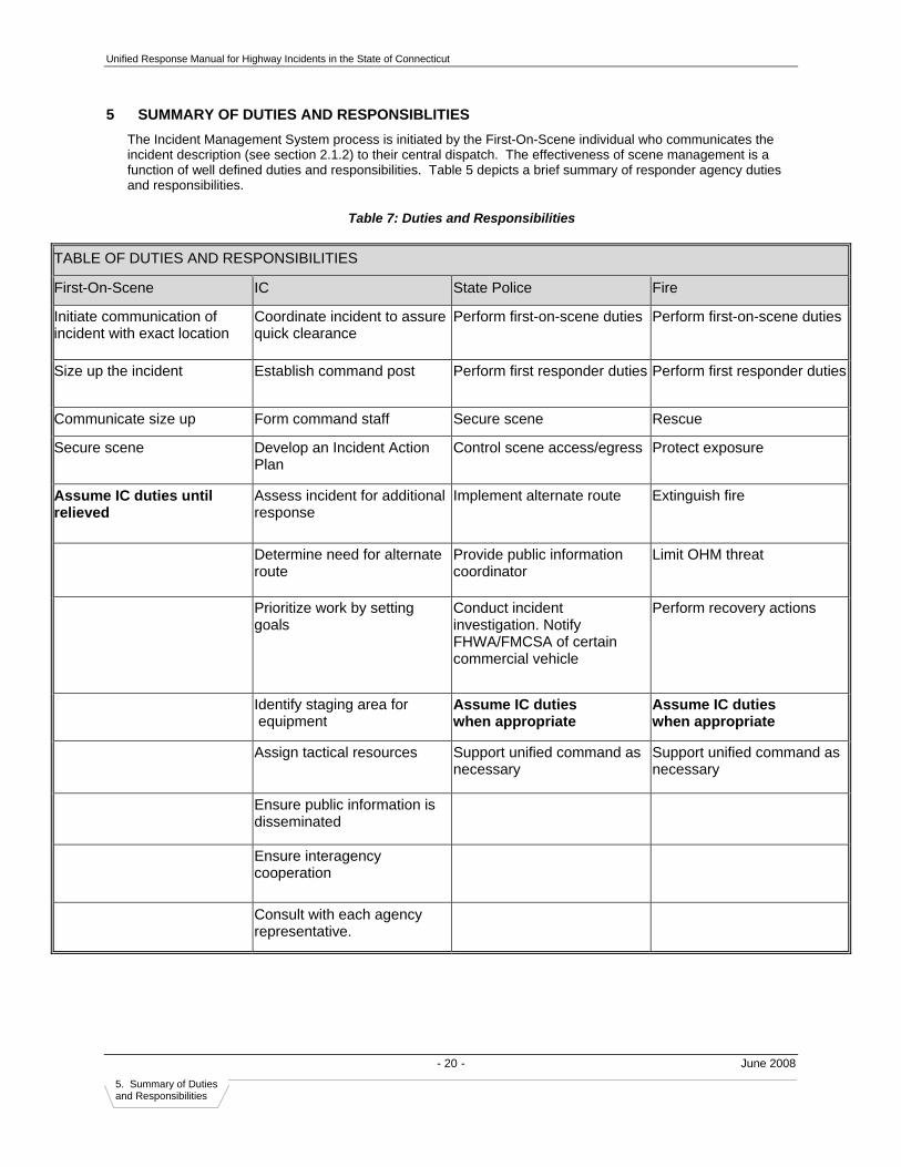
Unified Response Manual for Highway Incidents in the State of Connecticut
- 20 - June 2008 5. Summary of Duties and Responsibilities
5 SUMMARY OF DUTIES AND RESPONSIBLITIES The Incident Management System process is initiated by the First-On-Scene individual who communicates the incident description (see section 2.1.2) to their central dispatch. The effectiveness of scene management is a function of well defined duties and responsibilities. Table 5 depicts a brief summary of responder agency duties and responsibilities.
Table 7: Duties and Responsibilities
TABLE OF DUTIES AND RESPONSIBILITIES
First-On-Scene IC State Police Fire
Initiate communication of incident with exact location
Coordinate incident to assure quick clearance
Perform first-on-scene duties Perform first-on-scene duties
Size up the incident Establish command post Perform first responder duties Perform first responder duties
Communicate size up Form command staff Secure scene Rescue
Secure scene Develop an Incident Action Plan
Control scene access/egress Protect exposure
Assume IC duties until relieved
Assess incident for additional response
Implement alternate route Extinguish fire
Determine need for alternate route
Provide public information coordinator
Limit OHM threat
Prioritize work by setting goals
Conduct incident investigation. Notify FHWA/FMCSA of certain commercial vehicle
Perform recovery actions
Identify staging area for equipment
Assume IC duties when appropriate
Assume IC duties when appropriate
Assign tactical resources Support unified command as necessary
Support unified command as necessary
Ensure public information is disseminated
Ensure interagency cooperation
Consult with each agency representative.
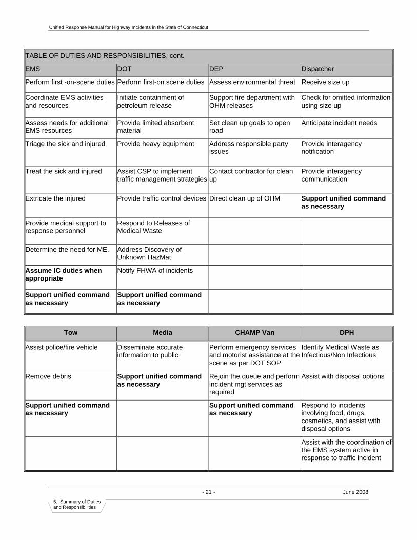
Unified Response Manual for Highway Incidents in the State of Connecticut
- 21 - June 2008 5. Summary of Duties and Responsibilities
TABLE OF DUTIES AND RESPONSIBILITIES, cont.
EMS DOT DEP Dispatcher
Perform first -on-scene duties Perform first-on scene duties Assess environmental threat Receive size up
Coordinate EMS activities and resources
Initiate containment of petroleum release
Support fire department with OHM releases
Check for omitted information using size up
Assess needs for additional EMS resources
Provide limited absorbent material
Set clean up goals to open road
Anticipate incident needs
Triage the sick and injured Provide heavy equipment Address responsible party issues
Provide interagency notification
Treat the sick and injured Assist CSP to implement traffic management strategies
Contact contractor for clean up
Provide interagency communication
Extricate the injured Provide traffic control devices Direct clean up of OHM Support unified command as necessary
Provide medical support to response personnel
Respond to Releases of Medical Waste
Determine the need for ME. Address Discovery of Unknown HazMat
Assume IC duties when appropriate
Notify FHWA of incidents
Support unified command as necessary
Support unified command as necessary
Tow Media CHAMP Van DPH
Assist police/fire vehicle Disseminate accurate information to public
Perform emergency services and motorist assistance at the scene as per DOT SOP
Identify Medical Waste as Infectious/Non Infectious
Remove debris Support unified command as necessary
Rejoin the queue and perform incident mgt services as required
Assist with disposal options
Support unified command as necessary
Support unified command as necessary
Respond to incidents involving food, drugs, cosmetics, and assist with disposal options
Assist with the coordination of the EMS system active in response to traffic incident
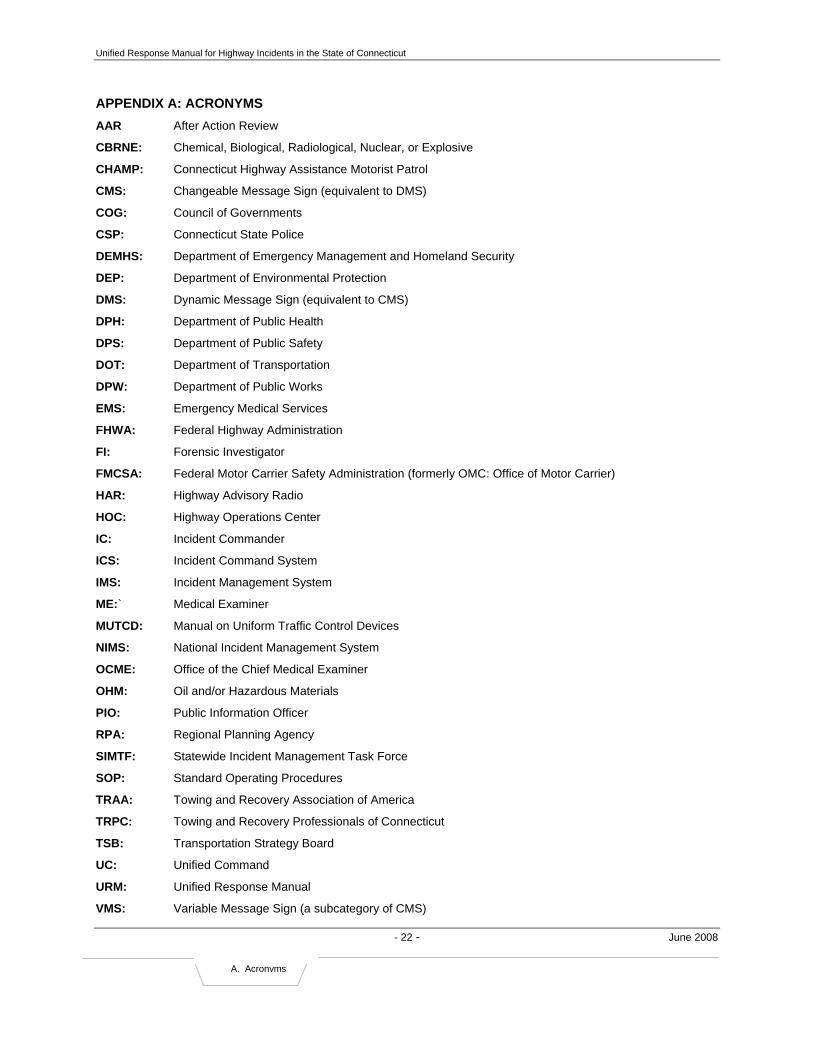
Unified Response Manual for Highway Incidents in the State of Connecticut
- 22 - June 2008
A. Acronyms
APPENDIX A: ACRONYMS AAR After Action Review
CBRNE: Chemical, Biological, Radiological, Nuclear, or Explosive
CHAMP: Connecticut Highway Assistance Motorist Patrol
CMS: Changeable Message Sign (equivalent to DMS)
COG: Council of Governments
CSP: Connecticut State Police
DEMHS: Department of Emergency Management and Homeland Security
DEP: Department of Environmental Protection
DMS: Dynamic Message Sign (equivalent to CMS)
DPH: Department of Public Health
DPS: Department of Public Safety
DOT: Department of Transportation
DPW: Department of Public Works
EMS: Emergency Medical Services
FHWA: Federal Highway Administration
FI: Forensic Investigator
FMCSA: Federal Motor Carrier Safety Administration (formerly OMC: Office of Motor Carrier)
HAR: Highway Advisory Radio
HOC: Highway Operations Center
IC: Incident Commander
ICS: Incident Command System
IMS: Incident Management System
ME:` Medical Examiner
MUTCD: Manual on Uniform Traffic Control Devices
NIMS: National Incident Management System
OCME: Office of the Chief Medical Examiner
OHM: Oil and/or Hazardous Materials
PIO: Public Information Officer
RPA: Regional Planning Agency
SIMTF: Statewide Incident Management Task Force
SOP: Standard Operating Procedures
TRAA: Towing and Recovery Association of America
TRPC: Towing and Recovery Professionals of Connecticut
TSB: Transportation Strategy Board
UC: Unified Command
URM: Unified Response Manual
VMS: Variable Message Sign (a subcategory of CMS)

Unified Response Manual for Highway Incidents in the State of Connecticut
- 23 - June 2008
B. ICS Diagram
APPENDIX B: TYPICAL INCIDENT COMMAND SYSTEM The diagram below shows typical roles and responsibilities of agencies at the incident scene. The roles and responsibilities will change according to the dynamic focus of incident management (e.g., rescue, fire suppression, investigation, clearance, etc.). The Planning, Logistics, and Finance/ Administration Sections should be implemented as necessary.

Draft Unified Response Manual for Highway Incidents in the State of Connecticut
- 24 - June 2008
C. Applicable Statutes
APPENDIX C: APPLICABLE STATE STATUTES This appendix consists of excerpted passages from Connecticut’s General Statutes that have direct relevance to incident management activities along the state’s limited access highways.
Authority of Fire Officer During an Emergency (CT General Statute Section 7-313e):
Authority of fire officer during emergency. Notwithstanding any provision in the general statutes or a municipal ordinance to the contrary, the fire chief of the municipality, or any member serving in the capacity of fire-officer-in-charge, shall, when any fire department or company is responding to or operating at a fire, service call, or other emergency, within such municipality, have authority to (a) Control and direct emergency activities at such scene …
Connecticut’s Move-It Law (CT General Statute Section 4-224(d)):
(d) Each person operating a motor vehicle who is knowingly involved in an accident on a limited access highway which causes damage to property only shall immediately move or cause his motor vehicle to be moved from the traveled portion of the highway to an untraveled area which is adjacent to the accident site if it is possible to move the motor vehicle without risk of further damage to property or injury to any person.
Connecticut’s Good Samaritan Law (CT General Statute Section 52-557b):
(b) A paid or volunteer firefighter or police officer, a teacher or other school personnel on the school grounds or in the school building or at a school function, a member of a ski patrol, a lifeguard, a conservation officer, patrol officer or special police officer of the Department of Environmental Protection, or emergency medical service personnel, who has completed a course in first aid offered by the American Red Cross, the American Heart Association, the National Ski Patrol, the Department of Public Health or any director of health, as certified by the agency or director of health offering the course, and who renders emergency first aid to a person in need thereof, shall not be liable to such person assisted for civil damages for any personal injuries which result from acts or omissions by such person in rendering the emergency first aid, which may constitute ordinary negligence. No paid or volunteer firefighter, police officer or emergency medical service personnel who forcibly enters the residence of any person in order to render emergency first aid to a person whom such firefighter, police officer or emergency medical service personnel reasonably believes to be in need thereof shall be liable to such person for civil damages incurred as a result of such entry. The immunity provided in this subsection does not apply to acts or omissions constituting gross, willful or wanton negligence.

Draft Unified Response Manual for Highway Incidents in the State of Connecticut
- 25 - June 2008
D. HIM Policy
APPENDIX D: CONNECTICUT HIGHWAY INCIDENT MANAGEMENT POLICY
The State of Connecticut
HIGHWAY INCIDENT MANAGEMENT POLICY
History- Incident Management On November 5, 1992 the first statewide Incident Management policy was established and approved by four (4) commissioners of state agencies to build a highway response program that would minimize the impact of traffic related incidents on Connecticut’s highways. It is necessary to re-issue a revised Highway Incident Management policy to promote policy awareness not only by state agencies but to all first responders; the stakeholders who have the ability to mitigate and minimize unnecessary delays from occurring on Connecticut’s highways.
Incident-caused congestion impacts: Safety. Breakdowns, secondary accidents occurring upstream of the incident location, and debris on Connecticut’s busy highways create life-threatening hazards;
Efficiency. Congestion yields effectively less capacity and reduced roadway efficiency;
Economic Growth. Decreased road capacity due to congestion add real costs to all
existing businesses and discourages future growth;
Environment. Congestion degrades the environment by increasing fuel consumption and air pollution emissions.
Incident Management Policy In recognition of these issues and objectives, the Connecticut Department of Transportation (CDOT), the Connecticut Department of Motor Vehicles (CDMV), the Connecticut Department of Public Safety (CDPS), the Connecticut Department of Environmental Protection (CDEP) and the Connecticut Department of Consumer Protection agree that the implementation of a Highway Incident Management program is a top priority. Incident Management consists of a centrally organized effort focused on detecting, responding to, and clearing incidents to recover traffic flow. The Connecticut policy ensures that highway users receive the maximum possible benefit of an active highway incident management program that minimizes the impact of traffic-related incidents.
The state level incident response stakeholders of CDOT, CDMV, CDPS and CDEP are given shared responsibility and authority for implementing this policy, cooperatively and expeditiously, through a series of programmed activities. Additionally, other state agencies, such as the Connecticut Department of Consumer Protection will, on occasion, be involved in the response to a highway incident and have on-scene functions and responsibilities. The state agencies along with the enhanced group of local agencies and organizations involved will accept

Draft Unified Response Manual for Highway Incidents in the State of Connecticut
- 26 - June 2008
D. HIM Policy
and promote the concept of a team approach and will work collaboratively to achieve the overall objectives of this policy.
Several resources exist to enhance the ability to restore traffic flow in the most expeditious manner. These include the Unified Response Manual for Highway Incidents, Highway Diversion Plans, Electronic Scene Mapping and Diagramming equipment, patrol vehicle push bumpers, certified heavy-duty “recovery” wreckers, and the DOT Freeway Service Patrol (CHAMP). Incident Commanders and those agency personnel with functional on-scene management responsibilities should consider the use of these resources, to mitigate the effects of a highway incident and to promote the restoration of traffic flow in the most efficient manner possible.
Program Assessment and Accountability The performance of the Incident Management Program will be evaluated periodically. A quantitative assessment will be undertaken to produce a report card on program performance. Weaknesses will be noted and corrective strategies formulated through the development of performance measurements. This will permit an assessment of individual events with a view towards the successful implementation of incident management strategies and plans.
A Program for the Future It is the intent of the policy to build an integrated program that is continually improving on a daily basis through evaluation of past performance and incorporation of emerging Intelligent Transportation System (ITS) technology. The long-term objective of the policy is to achieve the combined goals of safety, efficiency, economic growth, and clean air, and therefore promote the advancement of ITS technologies to achieve improvements in highway incident management.
s//__________________________________
Ralph J. Carpenter, Commissioner Date: 12/1/06
Connecticut Department of Transportation
s//__________________________________
Leonard C. Boyle, Commissioner Date: 11/7/06
Connecticut Department of Public Safety
s//___________________________________
William Ramirez, Commissioner Date: 12/20/06
Connecticut Department of Motor Vehicles

Draft Unified Response Manual for Highway Incidents in the State of Connecticut
- 27 - June 2008
D. HIM Policy
s//___________________________________ Date: 4/4/07
Gina McCarthy, Commissioner
Connecticut Department of Environmental Protection
s//____________________________________ Date: 3/30/07
Jerry Farrell, Jr., Commissioner
Connecticut Department of Consumer Protection
s//__________________________________ Date: 3/5/07
Chief Richard McDonough, President
Connecticut Fire Chiefs' Association
s//__________________________________ Date: 2/13/07
Chief Edward Richards, President
Connecticut Career Fire Chiefs' Association
s//__________________________________ Date: 4/2/07
Chief Harry W. Rilling, President
Connecticut Police Chiefs Association
s//____________________________________ Date: 12/21/06
James Messer, President
Towing and Recovery Professionals of Connecticut, Inc.
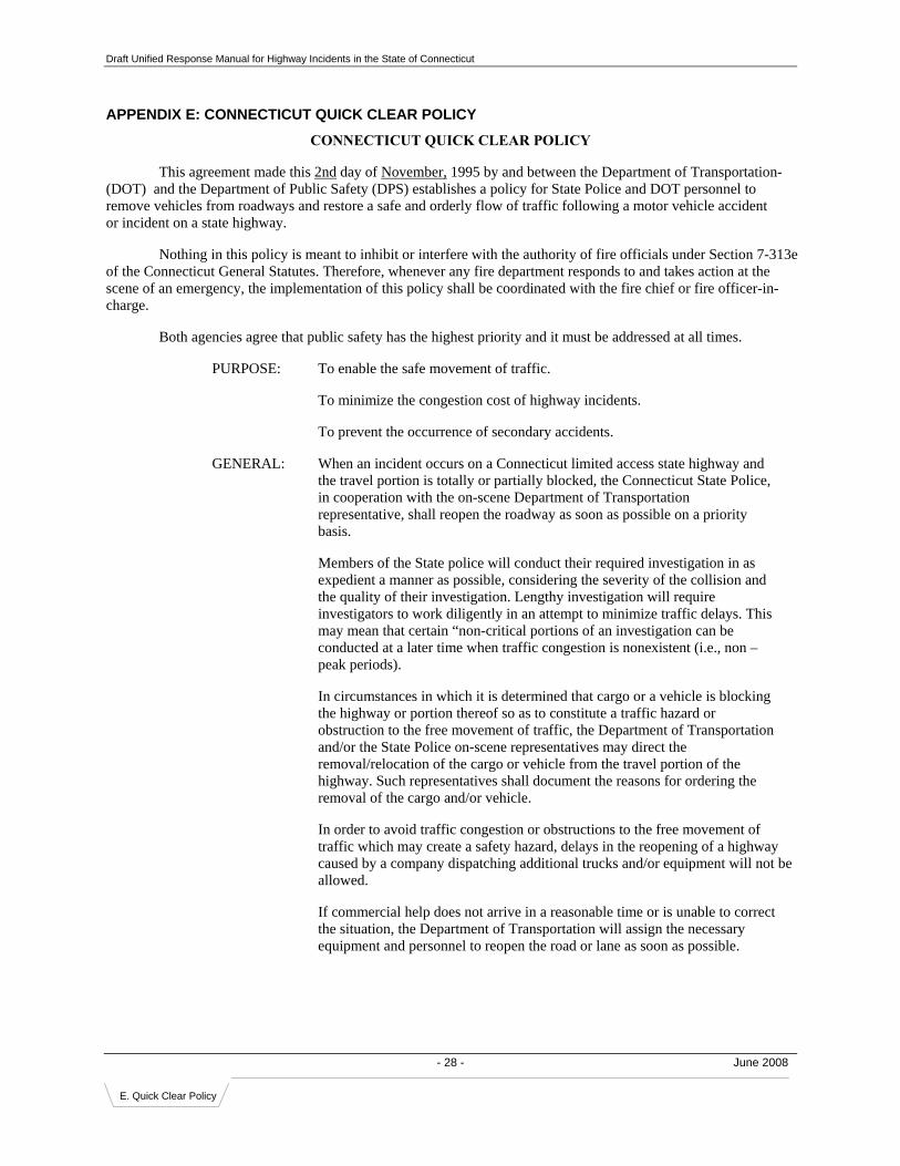
Draft Unified Response Manual for Highway Incidents in the State of Connecticut
- 28 - June 2008
E. Quick Clear Policy
APPENDIX E: CONNECTICUT QUICK CLEAR POLICY
CONNECTICUT QUICK CLEAR POLICY
This agreement made this 2nd day of November, 1995 by and between the Department of Transportation-(DOT) and the Department of Public Safety (DPS) establishes a policy for State Police and DOT personnel to remove vehicles from roadways and restore a safe and orderly flow of traffic following a motor vehicle accident or incident on a state highway.
Nothing in this policy is meant to inhibit or interfere with the authority of fire officials under Section 7-313e of the Connecticut General Statutes. Therefore, whenever any fire department responds to and takes action at the scene of an emergency, the implementation of this policy shall be coordinated with the fire chief or fire officer-in-charge.
Both agencies agree that public safety has the highest priority and it must be addressed at all times.
PURPOSE: To enable the safe movement of traffic.
To minimize the congestion cost of highway incidents.
To prevent the occurrence of secondary accidents.
GENERAL: When an incident occurs on a Connecticut limited access state highway and the travel portion is totally or partially blocked, the Connecticut State Police, in cooperation with the on-scene Department of Transportation representative, shall reopen the roadway as soon as possible on a priority basis.
Members of the State police will conduct their required investigation in as expedient a manner as possible, considering the severity of the collision and the quality of their investigation. Lengthy investigation will require investigators to work diligently in an attempt to minimize traffic delays. This may mean that certain “non-critical portions of an investigation can be conducted at a later time when traffic congestion is nonexistent (i.e., non –peak periods).
In circumstances in which it is determined that cargo or a vehicle is blocking the highway or portion thereof so as to constitute a traffic hazard or obstruction to the free movement of traffic, the Department of Transportation and/or the State Police on-scene representatives may direct the removal/relocation of the cargo or vehicle from the travel portion of the highway. Such representatives shall document the reasons for ordering the removal of the cargo and/or vehicle.
In order to avoid traffic congestion or obstructions to the free movement of traffic which may create a safety hazard, delays in the reopening of a highway caused by a company dispatching additional trucks and/or equipment will not be allowed.
If commercial help does not arrive in a reasonable time or is unable to correct the situation, the Department of Transportation will assign the necessary equipment and personnel to reopen the road or lane as soon as possible.

Draft Unified Response Manual for Highway Incidents in the State of Connecticut
- 29 - June 2008
E. Quick Clear Policy
-2-
Every effort will be made to remove all material to a safe location in the shortest time possible, using whatever equipment is necessary.
In witness whereof, each party hereto has caused this document to be executed in its name and on its behalf by its duly authorized officer or agent as of this day and year first above written.
/s/_______________________________ /s/___________________________ J. William Burns Kenneth H. Kirschner Commissioner Commissioner Department of Transportation Department of Public Safety Date: November 2, 1995 Date: October 16, 1995

Draft Unified Response Manual for Highway Incidents in the State of Connecticut
- 30 - June 2008
F. Traffic Devices
APPENDIX F: TEMPORARY TRAFFIC CONTROL DEVICES Below are typical traffic control devices that may be used to manage traffic at the scene. When requesting assistance from traffic control/transportation agencies, please use the correct terminology to prevent miscommunication.
Traffic Control Devices Purpose
Traffic Cones
Short-term roadside barriers to help re-route traffic
Detour Signs (Metal and Fabric)
Temporary lane closures, detours, and other advisory
information
Drums
Short- and long-term roadside barriers to help re-route traffic
Arrow Board – Vehicle Mounted
Temporary lane closures
Arrow Board Trailer Mounted
Temporary lane closures
Truck-Mounted Attenuators
Absorbs energy of vehicle impacts into the back of
responding vehicles
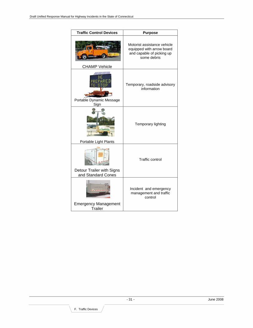
Draft Unified Response Manual for Highway Incidents in the State of Connecticut
- 31 - June 2008
F. Traffic Devices
Traffic Control Devices Purpose
CHAMP Vehicle
Motorist assistance vehicle equipped with arrow board and capable of picking up
some debris
Portable Dynamic Message Sign
Temporary, roadside advisory information
Portable Light Plants
Temporary lighting
Detour Trailer with Signs and Standard Cones
Traffic control
Emergency Management
Trailer
Incident and emergency management and traffic
control

Draft Unified Response Manual for Highway Incidents in the State of Connecticut
- 32 - June 2008
G. HazMat Check List
APPENDIX G: HAZMAT RECOGNITION CHECK LIST
HAZ MAT RECOGNITION CHECK LIST
1) SIGNS and SYMPTOMS a. VAPOR CLOUD b. ODORS c. LIQUID SPILLS RUNNING OFF FROM SCENE d. SOLID MATERIALS ON GROUND OR SPILLED FROM CONTAINERS. e. CONTAINER SHAPE(S)/SIZE(S) f. VEHICLE TYPE/SHAPE (i.e. – tanker, box truck) g. VISIBLE VICTIMS
- AMBULATROY OR NON-AMBULATORY - VISIBLE SYMPTOMS (i.e. – difficulty breathing, skin irritation/burns)
2) AVAILABLE RESOURCES a. ARE SHIPPING PAPERS ACCESSIBLE? b. IS HAZARDOUS MATERIAL IDENTIFIED? c. PLACARDS or UN NUMBERS

Draft Unified Response Manual for Highway Incidents in the State of Connecticut
- 33 - June 2008
H. Control Zone
APPENDIX H: ESTABLISHING CONTROL ZONE & VEHICLE POSITIONING ON SCENE
Guidelines for Vehicle Positioning at Highway Incidents22 GENERAL:
Providing a safe working area is a priority at every scene. Personnel should understand and appreciate the high risk while operating at an incident on a roadway and/or highway system. Personnel must operate in a defensive posture, always considering moving vehicles as a threat to their safety. Personnel must be aware that our own actions, inactions and practices can make a scene a more hazardous workplace (i.e. white strobe lights, headlights, non-reflective wear, failure to properly identify and block temporary work zone areas, saturation of work area with non-task assigned personnel).
TERMINOLOGY
1. Advanced Warning: Notification procedures that will advise approaching motorists to transition from normal driving status to that required by the temporary emergency traffic control measure ahead of them.
2. Block: Positioning fire department apparatus on an angle to the lanes of traffic creating a physical barrier between upstream traffic and the work area.
3. Buffer Zone: The distance or space between personnel and vehicles in the protected work zones and nearby moving traffic.
4. Downstream: The direction that traffic is moving as it travels away from the incident scene. 5. Incident Action Area: The area that will be affected by the emergency situation, that can include,
roadways, medians and any other part of the interstate system or peripheral area. 6. Shadow: The protected work area at a roadway incident, that is shielded by the block from apparatus. 7. Temporary Work Zone: The physical area of a roadway, within which emergency personnel perform the
fire, EMS, and rescue tasks. 8. Upstream: The direction that traffic is traveling from as the vehicles approach the incident scene.
APPARATUS POSITIONING
The initial officer on the scene must ASSESS the parking needs of later arriving apparatus and SPECIFICALLY DIRECT the parking and placement of these vehicles as they arrive to provide protective blocking of the scene. This officer is also the initial safety officer for the incident.
Responding apparatus, upon arrival, shall position as follows unless circumstances prohibit this guide in which case the Incident Commander (or Operator, if Command has not yet been established) shall position apparatus in such a manner as to provide the safest work area possible.
1. First arriving apparatus shall park to create a temporary work zone that protects personnel from on coming traffic in at least one direction. Block the most critical or highest volume direction first. The apparatus should be placed at a forty-five (45) degree angle to the curb. The buffer zone should be no closer than fifty (50’) to the incident action area. Whenever possible, the angle of the apparatus should protect anyone at the pump panel or control area. Operators should have front wheels rotated away from the incident. First arriving apparatus will block only those travel lanes necessary to provide a safe working area.
2. Second arriving apparatus shall position at the next critical position, either a. Further blocking the first arriving apparatus with appropriate distancing, b. Widening the initial blocked area, at least one lane wider than the width of the incident, or c. “Boxing” in the work area, leaving room on the downside for an appropriately sized work area. A forty-five (45) degree angle is preferred. The position of the apparatus shall take into consideration all factors that limit the sight distance of the approaching traffic including ambient lighting conditions, road conditions, weather related conditions, curves, bridges, hills and over/under passes.
EXITING APPARATUS
All responders shall take the following precautions:
1. Always maintain an acute awareness of the high risk of working around moving traffic.
22 Modified from the Town of Cheshire Fire Department’s Standard Operating Guideline III-21, regarding Roadway & Highway Operations, 2/5/07.

Draft Unified Response Manual for Highway Incidents in the State of Connecticut
- 34 - June 2008
H. Control Zone
2. Exit on curb side, or non-traffic side, if possible 3. Before exiting the apparatus check to assure you are safely entering the roadway. 4. Look down to recognize debris that could injure you or be projected into the work zone. Remove debris
hazard if/when safe to do so 5. NEVER turn your back on traffic 6. NEVER trust the traffic 7. Don PPE or high visibility reflective vests once outside apparatus***
PARKING OF SUPPORT VEHICLES
Responding support vehicles (Duty Officer, Radio cars) should not be used as blocking vehicles but may be used as warning vehicles. Ambulances fly cars, etc, should be past the incident in the shadow area.
The same precautions and requirements, as applied to apparatus (above), shall be observed by personnel assigned to support vehicles.
TEMPORARY WORK ZONE
The temporary work zone should be considered the “hot zone”, in which all personnel are considered to be at risk of being struck by a moving vehicle. The temporary work zone includes the path of travel from apparatus or support vehicles to the area of operations. Personnel staging (unassigned human resources) shall stay within the temporary work zone. Incident Commanders and personnel must remain vigilant at all times; even with proper actions personnel remain at risk from moving vehicles. Safety within the temporary work zone must be continually monitored and safety needs must be addressed as they arise.
SCENE SAFETY
1. During daytime operations, all visible warning devices shall be on to provide warning to drivers of vehicles approaching the scene.
2. During nighttime operations, use of white lights should be limited when possible. 3. Staging of vehicles, not involved in the temporary work zone or used for blocking, should be outside of
the immediate work area, generally downstream of the work area or otherwise where opposing traffic is not a significant concern.
4. For incidents of extended duration, it is strongly recommended that early warning devices be placed up stream of the work zone using the following distance chart as a gauge. Proper notification to the appropriate agency should be made by the OIC.
POSTED SPEED LIMIT DISTANCE
35 MPH 100 Ft
45 MPH 150 Ft
55 MPH 200 Ft
> 55 MPH 250 Ft
5. Remain vigilant during all phases of highway operations. 6. Do not rely on the State/Local-Police for maintaining scene safety on highways. This is your
responsibility.
CLEARING TRAFFIC LANES
Once operational phases are completed, apparatus may be repositioned to allow traffic to flow on as many lanes as possible. Unnecessary closing or restricting lanes increases the risk of a secondary incident. Crews, apparatus and equipment should be removed promptly to reduce exposure to traffic.
TERMINATING THE INCIDENT
Termination of the incident must be managed with the same aggressiveness as initial actions.

Draft Unified Response Manual for Highway Incidents in the State of Connecticut
- 35 - June 2008
H. Control Zone
Additional Considerations from the Connecticut State Police Administration & Operations Manual Safeguard the accident scene
Patrol vehicles should be parked to provide safety, but should not unnecessarily endanger the public.
(a) If possible, the patrol vehicle and other responding vehicles should be parked off the traveled portion of the highway with emergency lighting activated.
(b) It may be necessary to park behind persons or vehicles, which are disabled or otherwise cannot be immediately removed from the traveled portion of the highway.
(c) While parking vehicles, be alert to conditions, which make exiting the vehicle hazardous: such as fallen wires, fire hazards, locations with a likelihood of subsequent collisions wet, slippery pavement or pavement littered with debris.
(d) Tire marks on the highway or on shoulders may not be immediately evident but care should be taken to prevent obliteration.
(e) Unless the nature of the emergency precludes it, troopers in the roadway at an accident scene directing or controlling traffic should wear a reflective vest or rain coat for personal protection.
CALEA 61.3.2g
Additional items of note: 1. The lane closure diagrams on the following page are provided as examples of “best practices” and not substitutions
for decisions that need to be made relative to the details of the incident.
2. Periodic re-assessment of vehicle placement should take place on a regular basis.
3. Traffic should be channeled using whichever equipment the responder might have onboard their vehicle (cones or flares)
4. Traffic should not be allowed to pass on both sides of the incident.

Draft Unified Response Manual for Highway Incidents in the State of Connecticut
- 36 - June 2008
H. Control Zone
The diagrams below are recommended “Best Practices” but care should be taken to develop a Control Zone that is responsive to the particular needs of the incident. Vehicles are spaced approximately 25 feet apart and cones or flares are spaced approximately 10 feet apart.

Draft Unified Response Manual for Highway Incidents in the State of Connecticut
- 37 - June 2008
I. Towing
APPENDIX I: T.R.A.A. VEHICLE TOWING GUIDE The information in this Appendix is copyright and provided by the Towing and Recovery Association of America, Inc. (1-800-728-0136, 703-684-7713) and illustrated by Tow Times Magazine. TRAA has granted the South Central Regional Council of Government’s designee permission on December 21, 2006, to use the information in this Unified Response Manual for Highway Incidents in the State of Connecticut.
Clear communications between law enforcement and towing-and-recovery operators can ensure quick and efficient clearing of incidents and less disruption to traffic flow. To standardize communications, the towing industry has published this guide for use by incident responders.
When towing and recovery services are requested, the following information is necessary:
• Year, make, and model of the vehicle to be towed • DOT Class (Class 1-8 based on GVW) of the vehicle • Location of the vehicle • Type of tow (impound, accident, recovery, motorist
assistant, etc.) • Other vehicle information
- Two-wheel drive, 4-wheel drive, all-wheel drive - Damage to vehicle - Vehicle loaded or empty - Cargo contents (whether or not the cargo contains
hazardous materials as shown on the placard) - Does the vehicle have a trailer? - Are the keys with the vehicle?
Below are additional details about the above information.
• The vehicle year is critical for the towing operators to apply the correct towing procedures. The vehicle year is the eighth character from the right of the vehicle identification number (VIN), which is affixed to the chassis. In the example below, the vehicle year code in the VIN is the letter “S,” which corresponds to the year 1995, as shown in the table on the next page.
Veh. Year
Year Code*
Veh Year
Year Code*
Veh Year
Year Code*
1980 A 1991 M 2002 2
1981 B 1992 N 2003 3
1982 C 1993 P 2004 4 1983 D 1994 R 2005 5
1984 E 1995 S 2006 6 1985 F 1996 T 2007 7
1986 G 1997 V 2008 8
1987 H 1998 W 2009 9
1988 J 1999 X 2010 A
1989 K 2000 Y 2011 B
1990 L 2001 1 2012 C * The eighth character in the VIN Code
• The Gross Vehicle Weight Rating (GVWR) can be found on the identification label on the driver-side doorframe of the vehicle. Compare the number of pounds listed on the label to the weight in the illustrations show below for the correct DOT Vehicle Class.
1P8ZA1279SZ215470“S” = 1995 Vehicle Year
1P8ZA1279SZ215470“S” = 1995 Vehicle Year

Draft Unified Response Manual for Highway Incidents in the State of Connecticut
- 38 - June 2008
I. Towing
CLASS 1 ● LIGHT-DUTY ● (6,000 lb or less GVW – 4 tires)
CLASS 2 ● LIGHT-DUTY ● (6,001 – 10,000 lb GVW – 4 tires)
CLASS 1 ● LIGHT-DUTY ● (6,000 lb or less GVW – 4 tires)
CLASS 2 ● LIGHT-DUTY ● (6,001 – 10,000 lb GVW – 4 tires)
Classes 1 and 2 include passenger cars, light trucks, minivans, full size pickups, sport-utility vehicles, and full size vans.
CLASS 3 ● MEDIUM-DUTY ● (10,001 – 14,000 lb GVW – 6 tires or more)CLASS 3 ● MEDIUM-DUTY ● (10,001 – 14,000 lb GVW – 6 tires or more)
CLASS 4 ● MEDIUM-DUTY ● (14,001 – 16,000 lb GVW – 6 tires or more)
CLASS 5 ● MEDIUM-DUTY ● (16,001 – 19,500 lb GVW – 6 tires or more)
CLASS 6 ● MEDIUM-DUTY ● (19,501 – 26,000 lb GVW – 6 tires or more)
CLASS 4 ● MEDIUM-DUTY ● (14,001 – 16,000 lb GVW – 6 tires or more)
CLASS 5 ● MEDIUM-DUTY ● (16,001 – 19,500 lb GVW – 6 tires or more)
CLASS 6 ● MEDIUM-DUTY ● (19,501 – 26,000 lb GVW – 6 tires or more)
Classes 3 through 6 include a wide range of mid-size vehicles, delivery trucks, utility vehicles, motor-homes, parcel trucks, ambulances, small dump trucks, landscape trucks, flatbed and stake trucks, refrigerated and box trucks, small and medium school buses, and transit busses.
CLASS 7 ● HEAVY-DUTY ● (26,001 – 33,000 lb GVW – 6 tires or more)CLASS 7 ● HEAVY-DUTY ● (26,001 – 33,000 lb GVW – 6 tires or more)
Classes 7 and 8 (see illustrations of Class 8 on the next page) include a wide range of heavy vehicles, large delivery trucks, motor coaches, refuse trucks, cement mixers, and all tractor-trailer combinations (including double trailers).
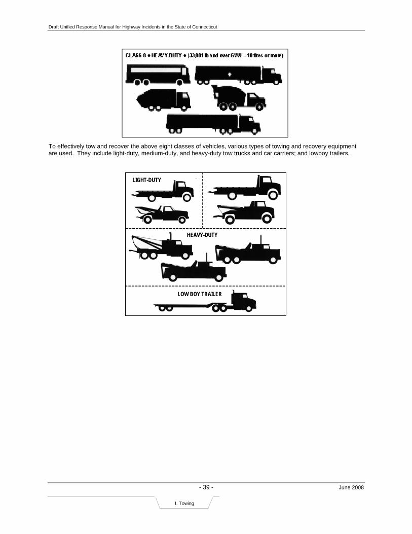
Draft Unified Response Manual for Highway Incidents in the State of Connecticut
- 39 - June 2008
I. Towing
To effectively tow and recover the above eight classes of vehicles, various types of towing and recovery equipment are used. They include light-duty, medium-duty, and heavy-duty tow trucks and car carriers; and lowboy trailers.
LIGHT-DUTY
HEAVY-DUTY
MEDIUM-DUTY
LOW BOY TRAILER
LIGHT-DUTY
HEAVY-DUTY
MEDIUM-DUTY
LOW BOY TRAILER

Draft Unified Response Manual for Highway Incidents in the State of Connecticut
- 40 - June 2008
J. Diversion Routes
APPENDIX J: DOT HIGHWAY OPERATIONS DIVERSION ROUTE PLANS
This appendix contains a list of the DOT Highway Operations Diversion Route Plans that are available as of March 2007. Additional diversion route plans are under development. During an incident, DOT personnel on scene, HOC personnel, and law enforcement personnel should have access to these diversion route plans.
• I-91 New Haven to Wallingford
• I-91 Wallingford to Mass. State Line*
• I-84 Plainville to Mass. State Line*
• I-95 Greenwich to Branford
• I-95 Guilford to Old Saybrook
• I-95 Old Lyme to Rhode Island State Line
• I-395 East Lyme to Norwich
• Route 66 Middletown/Portland
• Route 8 Shelton to Beacon Falls
• Highway to Highway in the Capitol Region*
o Rt. 15, I-291, Rt. 2, Rt. 3, I-84 & I-91
*Available online at www.crcog.org Click through to RED Plan page

Draft Unified Response Manual for Highway Incidents in the State of Connecticut
- 41 - June 2008
K. After Action Reviews
APPENDIX K:
After Action Report Form
Executive Summary Chapter 1: Incident Overview
Incident Name: List formal name of the incident.
Duration: List the total length of the incident. Incident Date: List the Month, Day, and Year of the incident. Sponsor: List the lead agency of the incident.
Classification: List the appropriate classification of the incident: Unclassified (U), For Official Use Only (FOUO), or By Invitation Only (IO). Scenario: List the scenario of the incident. Location: List all applicable information regarding the specific location of the Incident, including Highway Route Number, distance from nearest Interchange if available, the City, State, Federal Region, International Country, Military Installation, if applicable.
Note: The “Executive Summary” section should be used to briefly describe a summary of the information contained in an After Action Report (AAR) to highlight the way in which the report will assist agencies in striving for preparedness excellence and should include the following:
• Brief overview of the incident • Major strengths demonstrated during the incident • Areas that require improvement
Note: The “Incident Overview” section should be used to briefly describe the following:
• Describes the specific details of the incident • Identifies the agencies and organizations that participated in the incident • Describes how the incident was structured
Listed below are the incident specifications that are required in the AAR “Incident Overview” section.

Draft Unified Response Manual for Highway Incidents in the State of Connecticut
- 42 - June 2008
K. After Action Reviews
Participants: List the individual participating organizations or agencies, including the Federal, State, and Local agencies as well as International Agencies, if applicable. Number of Participants: List the total number of responders. Incident Overview: Briefly describe the incident components and the primary mission of each. Incident Evaluation: Briefly describe the specific evaluative tools in place for this incident.
Chapter 2: Incident Goals and Objectives Chapter 3: Incident Events Synopsis
Note: The “Incident Goals and Objectives” section should be used to briefly list the goals and objectives for the incident. These were developed during the incident planning phase and were used to define the scope and content of the incident as well as the agencies and organizations that responded.
List each Goal followed by the Objective for the respective Goal.
Note: The “Incident Events Synopsis” section should be used to provide an overview of the incident and the actions taken by the responders The actions are presented in the general sequence and timeline that they happened at each event. The events synopsis provides officials and responders with an overview of what happened at each location and when. It is also used to analyze the effectiveness of the response, especially the time sensitive actions. It provides a means of looking at the ramifications of one action not happening when expected on actions taken by other responders and on the overall response. The “Incident Events Synopsis” should include the synopsis, the modules for the incident, and a timeline of events for each element.

Draft Unified Response Manual for Highway Incidents in the State of Connecticut
- 43 - June 2008
K. After Action Reviews
Chapter 4: Analysis of Mission Outcomes
Chapter 5: Analysis of Critical Task Performance
Note: The “Analysis of Mission Outcomes” section provides an analysis of how well the participating agencies/ jurisdictions addressed the mission outcomes. Mission outcomes are those broad outcomes or functions that the public expects from its public officials and agencies. The mission outcomes include: prevention/deterrence, emergency assessment, emergency management, hazard mitigation, public protection, victim care, investigation/ apprehension, recovery/remediation. The incident goals and objectives will define the mission outcomes that are addressed by the incident and that should be analyzed in this section of the AAR.
This section analyzes how well the participating jurisdictions as a whole achieved the expected mission outcomes in their response to an event. The focus of this analysis is on outcomes rather than processes. The mission outcomes are actions the public expects from its public officials and agencies during an incident of this type. Results for each mission outcome should be summarized by outcome area. A detailed analysis of the activities and processes that contributed to results related to the mission outcomes will be in the following chapter.
Note: The “Analysis of Critical Task Performance” section reviews performance of the individual tasks. Each task that was identified by each response agency as a critical task to be performed to respond to the event should be discussed in this section. Those tasks that were performed as expected require only a short write up that describes how the task was performed and generally would be not be followed by recommendations. For tasks that were not performed as expected, the write-up should describe what happened or did not happen and the root causes for the variance from the plan or established procedures or agreements. Recommendations for improvement should be presented for these tasks. This section should indicate if the variance from expected performance resulted in an improved response, which may result in a recommendation that plans or procedures be changed. Innovative approaches that were used during the response should be highlighted and described. To facilitate tracking of recommendations and improvements, acronyms should be spelled out in each recommendation.
(continued on next page)
Draft Unified Response Manual for Highway Incidents in the State of Connecticut
- 44 - June 2008
K. After Action Reviews
Task: List the overall task and number. Issue: List the issue number and statement.
Reference: List the reference Incident Evaluation Guide (EEG) task and number. Summary of Issue: Briefly describe the issue. Consequence: Briefly state the consequence of the action. Analysis: Briefly explain the issue and the consequences. Recommendations: List the recommendation that would help to rectify the issue. Actions: List the action steps required to ensure that the recommendation is followed. Section 6: Conclusions This template has been based on the Homeland Security Exercise and Evaluation Program (HSEEP) Volume III: Exercise Evaluation and Improvement Planning, available on the Lessons Learned Information Sharing website: www.llis.gov (registration required.)
Note: The “Conclusions” section of the report should be used as a summary of all the sections of the AAR. It should include the following:
• Participants demonstrated capabilities • Lessons learned for improvement and major recommendations • A summary of what steps should be taken to ensure that the concluding results
will help to further refine plans, procedures, training for this type of incident.
Following the review and validation of the draft report findings by key officials from the participating agencies/jurisdictions (during the debriefing meeting), the officials define the actions that will be taken to address the recommendations. These improvement actions are presented following each recommendation and include the action, the responsible party/agency, and the timeline for completion.
Below is the format that each Task should be presented in.

Draft Unified Response Manual for Highway Incidents in the State of Connecticut
- 45 - June 2008
L. Contact Information
APPENDIX L: CONTACT INFORMATION
AGENCY PHONE 24-HR? Connecticut Department of Agriculture
Hartford Office (860) 713-2500 or (800) 861-9939
Connecticut Department of Consumer Protection
Hartford Office (860) 713-6050
Connecticut Department of Emergency Management and Homeland Security
Hartford Office (860) 566-3180 Yes
Connecticut Department of Environmental Protection
DEP Emergency Response and Spill Prevention Division
(860) 424-3338 or (866) 337-7745 Yes
Connecticut Department of Transportation Bridgeport and Newington Highway Operations Centers
(800) 695-0444 Yes
Connecticut Office of the Chief Medical Examiner
OCME, Farmington Office (860) 679-3980 or (800) 842-8820
Connecticut Military Department – Emergency Operations Center
Hartford Office (860) 724-5780 Yes
Connecticut State Police
Connecticut State Police – Message Center (860) 685-8190 (800) 842-0200 Yes
Connecticut State Police – Western District HQ, Litchfield (800) 203-0004
Connecticut State Police – Central District HQ, Meriden (203) 630-5640
Connecticut State Police – Eastern District HQ, Norwich (860) 886-5558
Connecticut State Police – Troop A, Southbury (800) 376-1554 Yes
Connecticut State Police – Troop B, Canaan (800) 497-0403 Yes
Connecticut State Police – Troop C, Tolland (800) 318-7633 Yes
Connecticut State Police – Troop D, Danielson (800) 954-8828 Yes
Connecticut State Police – Troop E, Montville (800) 953-7747 Yes
Connecticut State Police – Troop F, Westbrook (800) 256-5761 Yes
Connecticut State Police – Troop G, Bridgeport (800) 575-6330 Yes
Connecticut State Police – Troop H, Hartford (800) 968-0664 Yes
Connecticut State Police – Troop I, Bethany (800) 956-8818 Yes
Connecticut State Police – Troop K, Colchester (800) 546-5005 Yes
Connecticut State Police – Troop L, Litchfield (800) 953-9949 Yes
Connecticut State Police – Troop W, Bradley International Airport (888) 495-8213 Yes
Towing and Recovery Professionals of Connecticut
Cheshire Office (800) 430-6486 Yes
24-Hour Number (800) 216-8633 Yes

Draft Unified Response Manual for Highway Incidents in the State of Connecticut
- 46 - June 2008
L. Contact Information
AGENCY PHONE 24-HR? Local Police
Bridgeport Police (203) 576-7614 Yes
Hartford Police (860) 523-5203 (routine) (860) 233-2121 (emergency)
Yes
New Haven Police (203)946-6252 Yes
Stamford Police (203) 977-4921 Yes
Waterbury Police (203) 574-6911 Yes
Transit Districts
Connecticut Transit - Hartford (860) 525-3191 Yes
Connecticut Transit – New Haven (203) 867-6322 Yes
Connecticut Transit - Stamford (203) 348-9144 Yes
Connecticut Transit – New Britain / Bristol (860) 828-0511
Connecticut Transit – Meriden / Wallingford (800) 704-3113
Estuary Transit District (860) 388-1611
Greater Bridgeport Transit Authority (203) 333-3031
Greater Hartford Transit District (860) 247-5329
Greater New Haven Transit District (203) 288-6282
Greater Waterbury Transit District (203) 573-8627
Housatonic Area Rapid Transit (203) 748-2034
Meriden Transit District (203) 235-6851
Middletown Transit District (860) 346-0212
Milford Transit District (203) 874-4507
Northeastern Connecticut Transit District (860) 774-3902
Northwestern Connecticut Transit District (860) 489-2535
Norwalk Transit District (203) 852-0000
Southeast Area Transit (860) 886-2631
Valley Transit District (203) 735-6824
Windham Region Transit District (860) 456-2223
Railroads
Amtrak (800) 331-0008 (800) 872-7245 (800) USA-RAIL
Yes
Metro North Railroad (800) 638-7646
Shore Line East Commuter Rail (800) ALL-RIDE (800) 255-7433

Draft Unified Response Manual for Highway Incidents in the State of Connecticut
-47- June 2008
Notes
NOTES
This Unified Response Manual for Highway Incidents in the State of Connecticut was developed by the members of the Connecticut Transportation Strategy Board’s Statewide Incident Management Task Force, with the assistance of IBI Group, Cambridge, MA. Funding was provided by the U.S. Federal Highway Administration, Connecticut Department of Transportation, and the South Central Regional Council of Governments.
The framework of this manual and some best practices were adopted from the 2005 Maryland State Highway Administration/CHART Program and the Massachusetts Highway Department’s Unified Response Manual for Roadway Traffic Incidents, July 1998. Additional best practices were identified from the Ohio Department of Transportation QuickClear program.
This URM was adopted by the Statewide Incident Management Task Force on June 16, 2008 and by the Transportation Strategy Board on July 17, 2008.
For more information, please contact:
TBD

Guidelines for Use of Traffic Diversion Plans Effective June 1, 1998 (revised 4/1/04 & 1/1/08)
PLANS 1. Plans should be reviewed by appropriate personnel for accuracy. Any changes
should be brought to the attention of James Mona, Manager Highway Operations, ConnDOT , (860)594-2630 for preparation and distribution of revised sheets.
2. Effective June 1, 1998, diversion plans should be readily accessible for use by
dispatchers responsible for communicating with responding agencies. 3. Plans will be initiated after an assessment is made on-scene by State Police or the
Incident Commander. After location of the incident is identified and it is determined that a diversion plan will be required, the on-scene Trooper will notify the dispatcher of the diversion route.
NOTIFICATION 4. Using the appropriate response plan code (noted on lower right of diversion plan,
Ex. RPW 13) the State Police dispatcher will:
a) notify local police departments as required, and
b) notify ConnDOT Highway Operations 5. Upon receiving the response plan coding from State police, local police will
utilize the appropriate response plan to identify those intersections which require local police monitoring.
6. ConnDOT will:
a) activate changeable message signs, where available,
b) activate highway advisory radio system,
c) contact appropriate State personnel and regional agencies,
d) adjust signal system timing, if necessary,
e) implement diversion assurance signing on the detour route. CLEARING 7. When the incident is cleared, the State police dispatcher will advise:
a) local police departments as required, and
b) ConnDOT. 8. Upon receiving notification that the incident is cleared, ConnDOT will notify
appropriate State and regional agencies.

January 11, 2011 TRAFFIC DIVERSION PLAN FOR I-84 AND ROUTES 7 AND 8
Wilbur Smith Associates B Council of Governments of the Central Naugatuck Valley
APPENDIX B: DEMHS Regional Maps

January 11, 2011 TRAFFIC DIVERSION PLAN FOR I-84 AND ROUTES 7 AND 8
Wilbur Smith Associates C Council of Governments of the Central Naugatuck Valley
APPENDIX C: Stakeholder Comments
MEETING SUMMARY
1
SUBJECT: Traffic Diversion Plan for I-84 and Parts of Routes 7 & 8
MEETING DATE: September 22, 2010
TIME: 1:15 PM – 2:45 PM
LOCATION: Cheshire Police Department, 500 Highland Avenue, Cheshire, CT
PURPOSE: Towns of Cheshire, Southington, and Prospect Stakeholder Meeting
ATTENDEES:
Name Organization Phone Email
Mark Sciota Town of Southington 860-276-6221 [email protected]
Michael Cruess Cheshire Police Department 203-271-5500 [email protected]
Bob Chatfield Town of Prospect Mayor/Assistant Fire Chief
203- 758-4461 [email protected]
Steven Savage NWCT Public Safety Commission 203-758-0050 [email protected]
Nelson Abarzua Prospect Resident Trooper 203-758-6150 [email protected]
Jack Casner Cheshire Fire Department 203-272-1828 [email protected]
Harold Clark Southington Fire Department 860-621-3202 [email protected]
Joseph Michelangelo Cheshire Engineering 203-271-6650 [email protected]
Michael A. Milone Cheshire Town Manager 203-271-6660 [email protected]
Jack Daly Southington Police Department 860-378-1601 [email protected]
Joe Perrelli Council of Governments of the Central Naugatuck Valley (COG-CNV)
203-757-0535 [email protected]
Sharat Kalluri Wilbur Smith Associates 203-865-2191 [email protected]
Kwesi Brown Wilbur Smith Associates 203-865-2191 [email protected]
Leslie Black Fitzgerald & Halliday, Inc. 860-247-7200 [email protected]
MEETING SUMMARY
Joe Perrelli of the COGCNV introduced the study team.
Sharat Kalluri outlined the agenda for the meeting and then presented the meeting objectives, to update the audience on study progress to date, discuss outstanding data collection items, present preliminary diversion plans, and gather input on the draft plans.
Project Area:
• I-84 from New York State line to Exit 27 in Connecticut
• Route 7 from Danbury to Brookfield

MEETING SUMMARY
2
• Route 8 from Exit 23 to Winchester
Progress to date:
Data collection task has been completed with the exception of the following items: fire hydrants within 500 feet of limited access highways, bridge standpipes, CTDOT maintenance facilities, gas stations, municipal public works garages, designated emergency shelters and confirmation of contact information. The study team asked the audience to review draft maps and provide input.
It was noted that when traffic is diverted from the highway, routes are selected based on functional classification to optimize traffic flow and that local, residential streets are avoided. Limited bridge clearances and one-way streets are also avoided when selecting a route. Diversion routes are the same for cars and trucks unless there is a bridge clearance or weight restriction issue.
Project Engineer, Kwesi Brown, presented the draft route diversion plans. Draft plans are available for Towns to review on the study ftp site (case sensitive). Sharat Kalluri asked for all concerned to review maps on the ftp site and provide any further comments within the next 2 weeks by October 15th:
ftp.wilbursmith.com
Username: DEMHS
Password: DiversionPlan
These plans are intended to be implemented when all lanes are closed one-way on the main highway and traffic needs to be diverted from the main highway. These plans are not to be used for partial lane closures. These maps are designed as exit-to-exit maps for closures between two exits versus a regional closure of multiple exits. He noted that Towns will be notified of the link to the final GIS database after study completion as well as a contact for who will be responsible for updating the database. Comments for draft maps were noted and stored on smartboard maps:
Questions and Comments:
• Sharat Kalluri noted that a section of I-84 Route Diversion Plan between Exit 27 in Southington to Route 72 in Plainville, CT is not part of this study and will be completed in next phase of study.
I-84 EB Closures between the following Exits:
• Exit 25A to 26 – Left to Austin Road to East Main Street to Exit 26.
• Exit 26 to 27 – instead go to Exit 25A
• no Town-owned traffic lights in Cheshire
• Cheshire police can access to blink; manually push button
• if diverted at 25A, you would have to close on-ramps at Exit 26.
• Are there specific VMS locations? – Not shown on this plan specifically; VMS are CTDOT-controlled
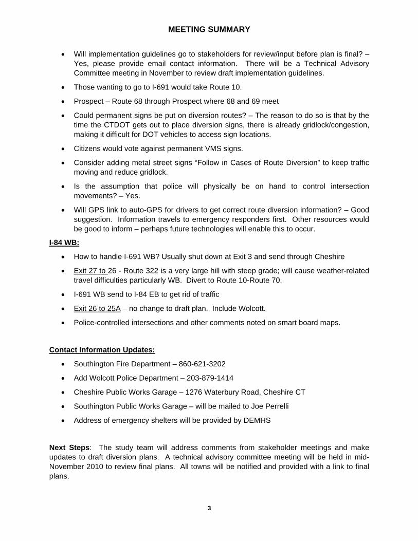
MEETING SUMMARY
3
• Will implementation guidelines go to stakeholders for review/input before plan is final? – Yes, please provide email contact information. There will be a Technical Advisory Committee meeting in November to review draft implementation guidelines.
• Those wanting to go to I-691 would take Route 10.
• Prospect – Route 68 through Prospect where 68 and 69 meet
• Could permanent signs be put on diversion routes? – The reason to do so is that by the time the CTDOT gets out to place diversion signs, there is already gridlock/congestion, making it difficult for DOT vehicles to access sign locations.
• Citizens would vote against permanent VMS signs.
• Consider adding metal street signs “Follow in Cases of Route Diversion” to keep traffic moving and reduce gridlock.
• Is the assumption that police will physically be on hand to control intersection movements? – Yes.
• Will GPS link to auto-GPS for drivers to get correct route diversion information? – Good suggestion. Information travels to emergency responders first. Other resources would be good to inform – perhaps future technologies will enable this to occur.
I-84 WB:
• How to handle I-691 WB? Usually shut down at Exit 3 and send through Cheshire
• Exit 27 to 26 - Route 322 is a very large hill with steep grade; will cause weather-related travel difficulties particularly WB. Divert to Route 10-Route 70.
• I-691 WB send to I-84 EB to get rid of traffic
• Exit 26 to 25A – no change to draft plan. Include Wolcott.
• Police-controlled intersections and other comments noted on smart board maps.
Contact Information Updates:
• Southington Fire Department – 860-621-3202
• Add Wolcott Police Department – 203-879-1414
• Cheshire Public Works Garage – 1276 Waterbury Road, Cheshire CT
• Southington Public Works Garage – will be mailed to Joe Perrelli
• Address of emergency shelters will be provided by DEMHS
Next Steps: The study team will address comments from stakeholder meetings and make updates to draft diversion plans. A technical advisory committee meeting will be held in mid-November 2010 to review final plans. All towns will be notified and provided with a link to final plans.

MEETING SUMMARY
1
SUBJECT: Traffic Diversion Plan for I-84 and Parts of Routes 7 & 8
MEETING DATE: September 28, 2010
TIME: 10:30 – 12:00 PM
LOCATION: Old Town Hall, 162 Whisconier Rd., Brookfield, CT
PURPOSE: Stakeholder Meeting: Bethel, Brookfield, Danbury, Newtown
ATTENDEES:
Name Organization Phone Email John Artes Troop A – New Fairfield 203-444-7473
Chris Levesque CTDOT Danbury
Paul Estefan Danbury Office of Civil Preparedness
203-797-4630 [email protected]
Bill Halstead Newtown 203-270-4370 [email protected]
Rory DeRocco Danbury Police 203-797-4611 ext. 223
Jon Chew Housatonic Valley Council of Elected Officials (HVCEO)
203-775-6256 [email protected]
Barry Julian CTDOT Southbury 203-264-5383
Ron Ferris DOT Danbury 203-797-4157
Jeff Finch Bethel PD 203-744-7900
Mike Kehoe Newtown Police Dept. (PD) 203-275-4256 [email protected]
Robin Montgomery Brookfield PD 203-775-3100 [email protected]
Tom Galliford Bethel EMD 203-794-8522 [email protected]
Jay Purcell Brookfield PD/DEMD 203-740-4102 [email protected]
Sharat Kalluri Wilbur Smith Associates 203-865-2191 [email protected]
Kwesi Brown Wilbur Smith Associates 203-865-2191 [email protected]
Shawn Callaghan Fitzgerald & Halliday, Inc. 860-265-4918 [email protected]
MEETING SUMMARY
Jon Chew of the HVCEO introduced the study team.
Sharat Kalluri outlined the agenda for the meeting and then presented the meeting objectives, to update the audience on study progress to date, discuss outstanding data collection items, present preliminary diversion plans, and gather input on the draft plans. He gave a project description, reviewed the project area and discussed the scope of work. Some field verification has been completed. He stated that the guidelines from the Hartford mapping were used as a guide for this study. There will be 110 maps total.
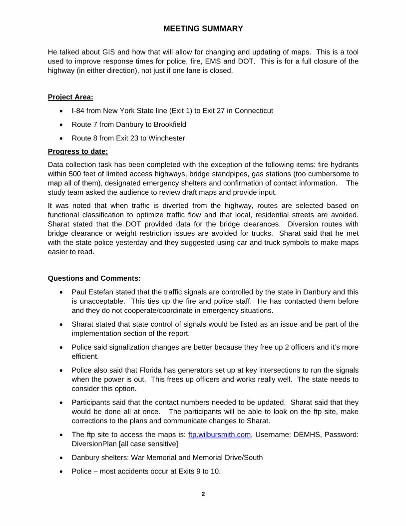
MEETING SUMMARY
2
He talked about GIS and how that will allow for changing and updating of maps. This is a tool used to improve response times for police, fire, EMS and DOT. This is for a full closure of the highway (in either direction), not just if one lane is closed.
Project Area:
• I-84 from New York State line (Exit 1) to Exit 27 in Connecticut
• Route 7 from Danbury to Brookfield
• Route 8 from Exit 23 to Winchester
Progress to date:
Data collection task has been completed with the exception of the following items: fire hydrants within 500 feet of limited access highways, bridge standpipes, gas stations (too cumbersome to map all of them), designated emergency shelters and confirmation of contact information. The study team asked the audience to review draft maps and provide input.
It was noted that when traffic is diverted from the highway, routes are selected based on functional classification to optimize traffic flow and that local, residential streets are avoided. Sharat stated that the DOT provided data for the bridge clearances. Diversion routes with bridge clearance or weight restriction issues are avoided for trucks. Sharat said that he met with the state police yesterday and they suggested using car and truck symbols to make maps easier to read.
Questions and Comments:
• Paul Estefan stated that the traffic signals are controlled by the state in Danbury and this is unacceptable. This ties up the fire and police staff. He has contacted them before and they do not cooperate/coordinate in emergency situations.
• Sharat stated that state control of signals would be listed as an issue and be part of the implementation section of the report.
• Police said signalization changes are better because they free up 2 officers and it’s more efficient.
• Police also said that Florida has generators set up at key intersections to run the signals when the power is out. This frees up officers and works really well. The state needs to consider this option.
• Participants said that the contact numbers needed to be updated. Sharat said that they would be done all at once. The participants will be able to look on the ftp site, make corrections to the plans and communicate changes to Sharat.
• The ftp site to access the maps is: ftp.wilbursmith.com, Username: DEMHS, Password: DiversionPlan [all case sensitive]
• Danbury shelters: War Memorial and Memorial Drive/South
• Police – most accidents occur at Exits 9 to 10.

MEETING SUMMARY
3
Project Engineer, Kwesi Brown, reviewed the route diversion plans when traffic needs to be diverted from the main highway. These maps are designed as exit-to-exit maps for closures between two exits versus a regional closure of multiple exits. He noted that Towns will be notified of link to final GIS database after study completion and a contact for who will be responsible for updating it. Comments for each draft map were recorded:
I-84 Eastbound
Exit 1 to 2:
Trucks: Should take a right and make the original route the secondary. First file saved on smartboard.
Exit 2 to 4:
Cars & trucks: OK
Exit 4 to 5:
Trucks:
- Not on current route
- low clearance on railroad bridge (10’)
- Segar Street, Park Avenue, and Backus Avenue for trucks
- Will do a hard copy map to show new route
Exit 5 to 6:
Ask Scott Billow if the town runs/owns this traffic signal.
Exit 6 to 7:
Recheck clearances, especially the pedestrian bridge at Western CT State University & Rt. 7. Saved on smartboard.
Exit 7 to 8:
Call out separately Rt. 7 to go north. Saved on the smartboard.
Exit 8 to 9:
Only way to go, route is OK.
Exit 9 to 10:
- Trucks should go down to Wassermann Ave.
- The flagpole is too had for trucks to navigate, especially in winter.
- Go to Exit 11
- Saved on smartboard.
Exit 10 to 11:
- Route shown is better truck route - PD
- Send cars to the flagpole - PD

MEETING SUMMARY
4
- Can send down River Road - DOT
- Saved on smartboard.
Exit 11 to 13:
Only crossing for Housatonic.
I-84 Westbound
Exit 10 – Saved on smartboard.
Route 7 Northbound
Murray Brook to Park:
PD – Use Sugar Hollow, it’s much quicker. Saved on the smartboard.
Park to Exit 4:
Need a new route for trucks. Saved on smartboard.
Exit 11 to 12 and 12 to the end:
I-84 Westbound
Exit 11 to 10:
Cars and trucks should be split up and cars should use Fairfield. Will wait for a fresh set of plans before the participants make changes. Saved on smartboard.
Exit 10 to 9:
Alternate route for trucks. Saved on smartboard.
Exit 8 to 6:
Can’t run trucks on White St. because of the Western CT State Univ. pedestrian walkway. Saved on smartboard.
Contact Information Updates:
Danbury: call Abdul
Bethel: FD same as PD
Newtown: (Couldn’t hear) -4360, Saved on smartboard.
FD – 203-270-4355, it’s a backup for 911
Brookfield: PD – 203-775-2575
Next Steps: The study team will address comments from stakeholder meetings and make updates to draft diversion plans. A technical advisory committee meeting will be held in mid-November 2010 to review final plans. All towns will be notified and provided with a link to final plans.

MEETING SUMMARY
1
SUBJECT: Traffic Diversion Plan for I-84 and Parts of Routes 7 & 8
MEETING DATE: September 22, 2010
TIME: 3:30 PM – 5:00 PM
LOCATION: Bethany Town hall, 40 Peck Road, 2nd Floor, Bethany, CT
PURPOSE: Town of Bethany Stakeholder Meeting
ATTENDEES:
Name Organization Phone Email
Rod White Town of Bethany Emergency Management
203-393-2100 [email protected]
Derrylyn Gorski Town of Bethany First Selectwoman 203-393-2100 x100
David Merriam Resident Trooper 203-393-2100 x129
Alan Green Director of Public Works/Assistant Fire Chief
203-393-1555 [email protected]
Sharat Kalluri Wilbur Smith Associates 203-865-2191 [email protected]
Kwesi Brown Wilbur Smith Associates 203-865-2191 [email protected]
Leslie Black Fitzgerald & Halliday, Inc. 860-247-7200 [email protected]
MEETING SUMMARY
Sharat Kalluri, project manager for Wilbur Smith Associates, introduced the study team.
Sharat outlined the agenda for the meeting and then presented the meeting objectives, to update the audience on study progress to date, discuss outstanding data collection items, present preliminary diversion plans, and gather input on the draft plans.
Project Area:
• I-84 from New York State line to Exit 27 in Connecticut
• Route 7 from Danbury to Brookfield
• Route 8 from Exit 23 to Winchester
Progress to date:
Data collection task has been completed with the exception of the following items: fire hydrants within 500 feet of limited access highways, bridge standpipes, CTDOT maintenance facilities, gas stations, municipal public works garages, designated emergency shelters and confirmation

MEETING SUMMARY
2
of contact information. The study team asked the audience to review draft maps and provide input.
It was noted that when traffic is diverted from the highway, routes are selected based on functional classification to optimize traffic flow and that local, residential streets are avoided. Limited bridge clearances and one-way streets are also avoided when selecting a route. Diversion routes are the same for cars and trucks unless there is a bridge clearance or weight restriction issue.
Project Engineer, Kwesi Brown, presented the draft route diversion plans. Draft plans are available for Towns to review on the study ftp site (case sensitive). Sharat Kalluri asked for all concerned to review maps on the ftp site and provide any further comments within the next 2 weeks by October 15th:
ftp.wilbursmith.com
Username: DEMHS
Password: DiversionPlan
These plans are intended to be implemented when all lanes are closed one-way on the main highway and traffic needs to be diverted from the main highway. These plans are not to be used for partial lane closures. These maps are designed as exit-to-exit maps for closures between two exits versus a regional closure of multiple exits. He noted that Towns will be notified of the link to the final GIS database after study completion as well as a contact for who will be responsible for updating the database.
Questions and Comments:
• No signals in town are police-monitored.
• Bethany will send the study team information on fire hydrants in close proximity to the highway.
• No bridge standpipes in Bethany.
• Route 42 is not a good choice for a diversion route; although it is a state highway, it is not well-lit and is very winding with sharp turns.
• Route 42 is an issue for tractor trailer trucks.
• Route 8 Northbound: Exit 22 one police monitor at off ramp right turn onto Route 67, police monitor left turn to Route 63 and straight run northbound to Exit 26.
• Cars can be directed left off Exit 22 to Route 67 to 84 WB if going to I-84 – might be difficult if it is not known where vehicles are heading; would require a VMS sign to let vehicles know. Without a sign, police would have to manually stop each truck. It is the responsibility of the CTDOT to sign the route.
• Same route for southbound.
Contact Information Updates:
• Bethany Fire Department – 203-393-2799

MEETING SUMMARY
3
• Municipal Garage – 203-393-1555; 755 Amity Road, Bethany, CT
• Emergency Shelters: 44 Peck Road – Bethany Community School; 190 Luke Hill Road – Amity Middle School
Next Steps: The study team will address comments from stakeholder meetings and make updates to draft diversion plans. A technical advisory committee meeting will be held in mid-November 2010 to review final plans. All towns will be notified and provided with a link to final plans.
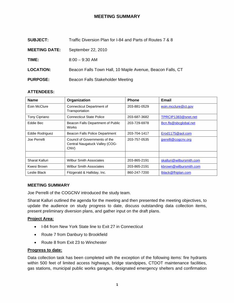
MEETING SUMMARY
1
SUBJECT: Traffic Diversion Plan for I-84 and Parts of Routes 7 & 8
MEETING DATE: September 22, 2010
TIME: 8:00 – 9:30 AM
LOCATION: Beacon Falls Town Hall, 10 Maple Avenue, Beacon Falls, CT
PURPOSE: Beacon Falls Stakeholder Meeting
ATTENDEES:
Name Organization Phone Email Eoin McClure Connecticut Department of
Transportation 203-881-0529 [email protected]
Tony Cipriano Connecticut State Police 203-687-3682 [email protected]
Eddie Bec Beacon Falls Department of Public Works
203-729-6978 [email protected]
Eddie Rodriguez Beacon Falls Police Department 203-704-1417 [email protected]
Joe Perrelli Council of Governments of the Central Naugatuck Valley (COG-CNV)
203-757-0535 [email protected]
Sharat Kalluri Wilbur Smith Associates 203-865-2191 [email protected]
Kwesi Brown Wilbur Smith Associates 203-865-2191 [email protected]
Leslie Black Fitzgerald & Halliday, Inc. 860-247-7200 [email protected]
MEETING SUMMARY
Joe Perrelli of the COGCNV introduced the study team.
Sharat Kalluri outlined the agenda for the meeting and then presented the meeting objectives, to update the audience on study progress to date, discuss outstanding data collection items, present preliminary diversion plans, and gather input on the draft plans.
Project Area:
• I-84 from New York State line to Exit 27 in Connecticut
• Route 7 from Danbury to Brookfield
• Route 8 from Exit 23 to Winchester
Progress to date:
Data collection task has been completed with the exception of the following items: fire hydrants within 500 feet of limited access highways, bridge standpipes, CTDOT maintenance facilities, gas stations, municipal public works garages, designated emergency shelters and confirmation

MEETING SUMMARY
2
of contact information. The study team asked the audience to review draft maps and provide input.
It was noted that when traffic is diverted from the highway, routes are selected based on functional classification to optimize traffic flow and that local, residential streets are avoided. Limited bridge clearances and one-way streets are also avoided when selecting a route. Diversion routes are the same for cars and trucks unless there is a bridge clearance or weight restriction issue.
Project Engineer, Kwesi Brown, presented the draft route diversion plans. Draft plans are available for Towns to review on the study ftp site (case sensitive). Sharat Kalluri asked for all concerned to review maps on the ftp site and provide any further comments within the next 2 weeks by October 15th:
ftp.wilbursmith.com
Username: DEMHS
Password: DiversionPlan
These plans are intended to be implemented only when all lanes are closed one-way on the main highway and traffic needs to be diverted from the main highway. These plans are not to be used for partial lane closures. These maps are designed as exit-to-exit maps for closures between two exits versus a regional closure of multiple exits. He noted that Towns will be notified of the link to the final GIS database after study completion as well as a contact for who will be responsible for updating the database. Comments regarding draft maps were noted and stored on smartboard maps:
Questions and Comments:
• Signs will be posted at key directional locations by CTDOT to indicate route diversion.
• Recent experience with closing Route 8 for filming a movie provided insight into protocol for advance warning to motorists on Route 8 using variable message systems (VMS) and police cruisers. VMS alone do not provide sufficient warning.
• Two-three extra police cruisers should be posted on the highway at strategic locations in advance of the exit to provide warning of change in traffic flow and slow traffic. Sight lines and distance to exit should be used to determine cruiser placement.
• Route 8 NB:
• Exit 22 to 23 - State police/resident troopers should be posted at key intersections along the route diversion to optimize traffic flow, including at Exit 22 on-ramp to prevent back-up.
• It was noted that it will be difficult to get emergency vehicles through congestion if Route 42 is blocked with rerouted traffic.
• As traffic is diverted off Route 8 at Exit 22, the light at the end of the ramp should be flashing yellow; a temporary stop sign should be posted for eastbound traffic on Route 42 approaching off-ramp intersection; traffic coming off the ramp should have free right turn and no left turn permitted, monitored by police.

MEETING SUMMARY
3
• Exit 24 to 25 - Other intersections on Route 42 to monitor with police presence: Blackberry (2 officers), Cook (1 officer)
• Police-controlled intersections and other comments noted on smart board maps.
Contact Information Updates:
• Beacon Falls Main Street traffic signals are controlled by town police (have key)
• Department of Public Works – signal system contact – 203-729-6978
• Department of Public Works noted there are no bridge standpipes.
• Bridgeport Hydraulic should have information on hydrant locations proximal to Route 8; they take care of hydrant maintenance for the Town.
• CTDOT maintenance facility is located in Beacon Falls at 401 Lopus Road
• Town emergency shelter is located at Woodland Regional High School, 135 Back Rimmon Road, Beacon Falls, CT
Next Steps: The study team will address comments from stakeholder meetings and make updates to draft diversion plans. A technical advisory committee meeting will be held in mid-November 2010 to review final plans. All towns will be notified and provided with a link to final plans.
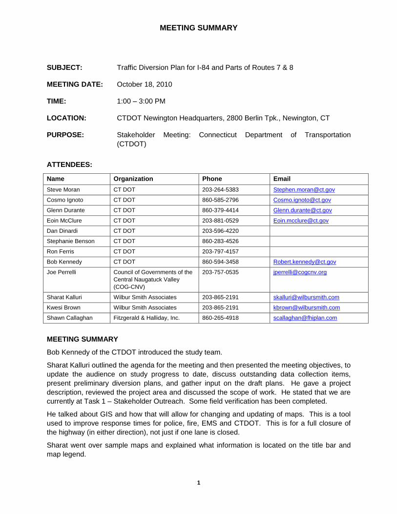
MEETING SUMMARY
1
SUBJECT: Traffic Diversion Plan for I-84 and Parts of Routes 7 & 8
MEETING DATE: October 18, 2010
TIME: 1:00 – 3:00 PM
LOCATION: CTDOT Newington Headquarters, 2800 Berlin Tpk., Newington, CT
PURPOSE: Stakeholder Meeting: Connecticut Department of Transportation
(CTDOT)
ATTENDEES:
Name Organization Phone Email
Steve Moran CT DOT 203-264-5383 [email protected]
Cosmo Ignoto CT DOT 860-585-2796 [email protected]
Glenn Durante CT DOT 860-379-4414 [email protected]
Eoin McClure CT DOT 203-881-0529 [email protected]
Dan Dinardi CT DOT 203-596-4220
Stephanie Benson CT DOT 860-283-4526
Ron Ferris CT DOT 203-797-4157
Bob Kennedy CT DOT 860-594-3458 [email protected]
Joe Perrelli Council of Governments of the
Central Naugatuck Valley
(COG-CNV)
203-757-0535 [email protected]
Sharat Kalluri Wilbur Smith Associates 203-865-2191 [email protected]
Kwesi Brown Wilbur Smith Associates 203-865-2191 [email protected]
Shawn Callaghan Fitzgerald & Halliday, Inc. 860-265-4918 [email protected]
MEETING SUMMARY
Bob Kennedy of the CTDOT introduced the study team.
Sharat Kalluri outlined the agenda for the meeting and then presented the meeting objectives, to
update the audience on study progress to date, discuss outstanding data collection items,
present preliminary diversion plans, and gather input on the draft plans. He gave a project
description, reviewed the project area and discussed the scope of work. He stated that we are
currently at Task 1 – Stakeholder Outreach. Some field verification has been completed.
He talked about GIS and how that will allow for changing and updating of maps. This is a tool
used to improve response times for police, fire, EMS and CTDOT. This is for a full closure of
the highway (in either direction), not just if one lane is closed.
Sharat went over sample maps and explained what information is located on the title bar and
map legend.

MEETING SUMMARY
2
Project Area:
I-84 from New York State line (Exit 1) to Exit 27 in Connecticut
Route 7 from Danbury to Brookfield
Route 8 from Exit 23 to Winchester
Progress to date:
Data collection task has been completed with the exception of the following items: fire hydrants
within 500 feet of limited access highways and bridge standpipes.
It was noted that when traffic is diverted from the highway, routes are selected based on
functional classification to optimize traffic flow and that local, residential streets are avoided.
Sharat stated that the CTDOT provided data for the bridge clearances. Diversion routes with
bridge clearance or weight restriction issues are avoided for trucks. Sharat said that he met
with the state police and 15-16 towns to gather stakeholder input on map routes.
Sharat outlined the general issues with the project currently:
Regional diversion routes will be developed for Danbury (Exit 3 to 8) and Waterbury
Alternate routes need to be developed for hazardous material incidents
- I-84/Rt. 8 Mixmaster in Waterbury is a particular focus area due to complexity of highway
system at that junction
- Specify distance of diversion route from incident
CTDOT Response time – takes too long (around 2 hrs), diversion signs may be placed
locally
State traffic signal system
Map symbology/legend – utility companies contact information to be included as
suggested by state police
Questions and Comments:
CTDOT – accidents hard to respond to quickly, especially when employees are at home
because they must report to headquarters first, then do traffic diversion
CTDOT – another issue is that CTDOT doesn’t get called for 45 minutes, fire/police must
handle injuries then secure scene, then CTDOT called for traffic diversion
Most local towns don’t have signs for diversions
CTDOT- good idea to find more than one route if possible, would help to alleviate
gridlock

MEETING SUMMARY
3
Sharat stated that state control of signals would be listed as an issue and be part of the
implementation guidelines section of the report.
Town-Specific Issues:
1. Glen Road bridge over the Housatonic River in Southbury, ability to handle 2-way
traffic
2. Danbury - West Street bridge, CTDOT representation at site visit in Danbury to
assess suitability of diversion routes for trucks
CTDOT – Glen Road bridge, add note on plans to put an officer there to direct traffic,
only option for hazardous materials (haz mat) situation, add haz mat route note
CTDOT – West Street bridge – go west to Segar Street
CTDOT – Exit 3 to Park Avenue, saved on smart board
Changes haven’t been made from last stakeholder meeting to maps
The ftp site to access the maps is: ftp.wilbursmith.com, Username: DEMHS, Password:
DiversionPlan [all case sensitive]
Next Steps: Plan to finish maps by the end of October. A technical advisory committee
meeting will be held in mid-November 2010 to review final plans. All towns will be notified and
provided with a link to final plans.

MEETING SUMMARY
1
SUBJECT: Traffic Diversion Plan for I-84 and Parts of Routes 7 & 8
MEETING DATE: September 29, 2010
TIME: 1:15 – 2:45 PM
LOCATION: Thomaston Police Department, 158 Main Street, Level 2
PURPOSE: Town of Thomaston Stakeholder Meeting
ATTENDEES:
Name Organization Phone Email Stephanie Benson Connecticut Department of
Transportation 860-283-4526 [email protected]
Paul Pronovost Thomaston Department of Public Works
860-283-4030 [email protected]
Daniela Ouellette Thomaston Ambulance 203-943-9460 [email protected]
Gene Torrence Thomaston Police Department 860-283-4343 [email protected]
Jamie Wilson Thomaston Fire Department 860-283-5268 [email protected]
Joe Perrelli Council of Governments of the Central Naugatuck Valley (COG-CNV)
203-757-0535 [email protected]
Sharat Kalluri Wilbur Smith Associates 203-865-2191 [email protected]
Leslie Black Fitzgerald & Halliday, Inc. 860-247-7200 [email protected]
MEETING SUMMARY
Joe Perrelli, Study Project Manager from the Council of Governments of the Central Naugatuck Valley introduced the study team. Sharat Kalluri, Consultant Project Manager from Wilbur Smith Associates, outlined the agenda for the meeting and then presented the meeting objectives, to update the audience on study progress to date, discuss outstanding data collection items, present preliminary diversion plans, and gather input on the draft plans.
Project Area:
• I-84 from New York State line to Exit 27 in Connecticut
• Route 7 from Danbury to Brookfield
• Route 8 from Exit 23 to Winchester
Progress to date:
Data collection task has been completed with the exception of the following items: fire hydrants within 500 feet of limited access highways, bridge standpipes, CTDOT maintenance facilities, gas stations, municipal public works garages, designated emergency shelters and confirmation

MEETING SUMMARY
2
of contact information. The study team asked the audience to review draft maps and provide input.
It was noted that when traffic is diverted from the highway, routes are selected based on functional classification to optimize traffic flow and that local, residential streets are avoided. Limited bridge clearances and one-way streets are also avoided when selecting a route. Diversion routes are the same for cars and trucks unless there is a bridge clearance or weight restriction issue.
Sharat Kalluri presented the draft route diversion plans. Draft plans are available for Towns to review on the study ftp site (case sensitive). He asked for all concerned to review maps on the ftp site and provide any further comments within the next 2 weeks by October 15th:
ftp.wilbursmith.com
Username: DEMHS
Password: DiversionPlan
These plans are intended to be implemented only when all lanes are closed one-way on the main highway and traffic needs to be diverted from the main highway. These plans are not to be used for partial lane closures. These maps are designed as exit-to-exit maps for closures between two exits versus a regional closure of multiple exits. He noted that Towns will be notified of the link to the final GIS database after study completion as well as a contact for who will be responsible for updating the database. Comments regarding draft maps were noted and stored on smartboard maps:
Questions and Comments:
• Police control the signals in Thomaston manually
• No bridge standpipes in Thomaston
• Hydrants located for Thomaston per Joe Perrelli.
• Action – Sharat Kalluri to mail CD of maps to Police Chief.
Route 8 Northbound Closure between the following Exits:
• Exit 36 to 37 – Route 262 and north on Old Waterbury Road
• police-monitoring at left turn at Huntington Homer
• police-monitoring at left turn at blinking light back to Exit 37
• Exit 37 to 38 – Route 262 right to Old Waterbury Road northbound (SR 848 – is more level)
• police-monitoring at Route 262 at Old Waterbury Road
• police-monitoring at circle
• leave original draft route diversion plan for a secondary car route on Route 6.
• Exit 38 to 39 – no change from proposed diversion plan.

MEETING SUMMARY
3
• from Route 254 north, there are six lights requiring police-stop-control.
• Exit 39 to 40 – no change from proposed diversion plan
• Exit 40 to 41 – take off Exit 38 to Route 6 to route 254 to Route 118 up to Exit 42.
Route 8 Southbound Closures between the following Exits:
• Exit 41 to 40 – Use Exit 42 to Routes 118, 254, 6 and on at Exit 38.
• Could split for secondary route at Exit 39 if needed.
• Exit 40 to 39 – no change from draft route
• sharp left should be police-monitored
• Exit 39 to 38 – no change
• Exit 38 to 37 – primary route should be Old Waterbury Road; secondary route should be Route 6 for cars only
• Exit 37 to 36 – police-monitoring at right turn; advance warning at Waterbury Road north of the route diversion.
Contact Information Updates:
• Emergency shelter locations will be provided to the study team by DEMHS as a GIS layer
• Use Police Department phone number for signal system
• Public Works Garage – 32 Reynolds Ridge Road, Thomaston, CT
Next Steps: The study team will address comments from stakeholder meetings and make updates to draft diversion plans. A technical advisory committee meeting will be held in mid-November 2010 to review final plans. All towns will be notified and provided with a link to final plans.

MEETING SUMMARY
1
SUBJECT: Traffic Diversion Plan for I-84 and Parts of Routes 7 & 8
MEETING DATE: September 27, 2010
TIME: 9:00 – 11:30 AM
LOCATION: 90 Lakeside Road Southbury, CT
PURPOSE: Troop A State Police Stakeholder Meeting
ATTENDEES:
Name Organization Phone Email George Battle CSP - WDHQ 860-626-7975 [email protected]
Thomas Begert CSP – I 203-393-4240 [email protected]
Robert Desmarais Troop A 203-267-2200 [email protected]
Michael Hofbauer Troop A 203-267-2200 [email protected]
David DelVecchia Troop B 860-824-2516 [email protected]
Dan Semosky Resident Trooper Oxford 203-888-4353 [email protected]
Ed Bednarz Troop A 203-267-2200 [email protected]
Mike O’Donnell CSP - A 203-264-5912 [email protected]
Orlando C. Mo CSP - A 860-309-5689 [email protected]
Adam Wagablas CSP - A 203-312-5701 [email protected]
Michael J. Gravel CSP - A 203-267-2200 [email protected]
Sharat Kalluri Wilbur Smith Associates 203-865-2191 [email protected]
Kwesi Brown Wilbur Smith Associates 203-865-2191 [email protected]
Leslie Black Fitzgerald & Halliday, Inc. 860-247-7200 [email protected]
MEETING SUMMARY
Lieutenant Bednarz provided an introduction about the study and his role on the study Technical Advisory Committee. He introduced Sharat Kalluri, project manager from Wilbur Smith Associates who introduced the study team.
Sharat outlined the agenda for the meeting and then presented the meeting objectives, to update the audience on study progress to date, discuss outstanding data collection items, present preliminary diversion plans, and gather input on the draft plans.
Project Area:
• I-84 from New York State line to Exit 27 in Connecticut
• Route 7 from Danbury to Brookfield
• Route 8 from Exit 23 to Winchester

MEETING SUMMARY
2
Progress to date:
Data collection task has been completed with the exception of the following items: fire hydrants within 500 feet of limited access highways, bridge standpipes, CTDOT maintenance facilities, gas stations, municipal public works garages, designated emergency shelters and confirmation of contact information. The study team asked the audience to review draft maps and provide input.
It was noted that when traffic is diverted from the highway, routes are selected based on functional classification to optimize traffic flow and that local, residential streets are avoided. Limited bridge clearances and one-way streets are also avoided when selecting a route. Diversion routes are the same for cars and trucks unless there is a bridge clearance or weight restriction issue.
Project Engineer, Kwesi Brown, presented several of the draft route diversion plans. Draft plans are available for state police to review on the study ftp site (case sensitive). Sharat Kalluri asked for all concerned to review maps on the ftp site and provide any further comments within the next 2 weeks by October 15th:
ftp.wilbursmith.com
Username: DEMHS
Password: DiversionPlan
These plans are intended to be implemented only when all lanes are closed one-way on the main highway and traffic needs to be diverted from the main highway. These plans are not to be used for partial lane closures. These maps are designed as exit-to-exit maps for closures between two exits versus a regional closure of multiple exits. Sharat noted that Towns and state police will be notified of the link to the final GIS database after study completion as well as a contact for who will be responsible for updating the database. Comments regarding draft maps were noted and stored on smartboard maps:
Questions and Comments:
• This plan is to take effect if the highway is to be shut completely in one or both directions for more than several hours – implementation guidelines will be developed to accompany the maps.
• This plan is for short term closures; a long term route diversion plan would be different.
• CRCOG website is the source for the I-84 route diversion plan from Hartford to the Massachusetts state line. The piece of the plan covering from Cheshire to Hartford will be completed immediately after this study is completed in December 2010.
• Troopers will be provided a link to the route diversion plan to bring up maps on their car computers.
• It was suggested that State Police IT group work with COGCNV to provide a final format that is workable for police systems.
• COGCNV is looking at grants for permanent signage to facilitate route diversions in common areas of traffic congestion (e.g. in Danbury, Waterbury).

MEETING SUMMARY
3
• State Police Troop A covers signals for Southbury and Oxford. Other local towns cover control of signal boxes in their respective towns.
• State Police will work with COGCNV to purchase more keys for signal boxes; newer cabinets use a single key.
• Signal operation is a module that needs to be taught at State Police – Lt. Bednarz will discuss further.
• CTDOT signals operate out of Newington via fiber optics. On certain routes, State Police need to reach out to CTDOT for signal changes.
• Gas company plans for feeder lines are not recorded on current diversion route maps – either provide a GIS layer for location of feeder lines or provide a contact number on all maps so that State Police can place a call to the gas utility to isolate service and prevent fire if there is a volatile situation on highway.
• State Police Command Post is not going to be recorded on this plan – State Police want to keep this determination fluid to suit the situation.
• Other contact numbers for HAZMAT – Lt. Bednarz will provide to the study team.
• Change coding on legend of maps – suggest changing arrows to truck or car symbols to designate car or truck routes; also use color-coding – easy for many to read and interpret quickly in intense situations.
• Try as much as possible to implement truck diversion routes with all right turns – left turns are difficult for large trucks and slow the progress of traffic.
• Provide Lt. Bednarz with updated legend of new color codes/symbols for review/input.
• Symbols work better than color-coding routes if maps are printed in black & white. Police vehicle computers show color on screen.
• The study team asked troopers to review maps that affect their respective areas. Make suggestions to the study team by email.
• The study team asked troopers to suggest multi-exit diversion routes
• Diversion route plan can assist State Police with planning for number of personnel required for implementation.
• Over-sized load considerations must be factored into the diversion route plan. CTDOT will restrict permits for over-sized loads if situation is known/long-term. Police take on liability if over-sized loads are rerouted from permitted route – better to take them off the road until the situation is resolved.
• Consider buffer zones of half mile and one mile in all directions for HAZMAT situations – route diversion plan will be impacted.
• Flexibility is key – the route diversion plan is the foundation and State Police need flexibility of implementation as situation requires.
• NB on Route 8 – Exit 19 to 22 – should have secondary route that moves traffic away from under the bridge if HAZMAT situation occurs. Add in “Special Requirements” box

MEETING SUMMARY
4
on map the instruction for secondary route in case of HAZMAT situation. Use Routes 44, 50, 91.
• Meadow Street is a mistake if route diversion plan calls for complete highway closure and rerouting both directions of traffic.
• State Police will review other maps and provide comments by email to the study team.
Next Steps: The study team will address comments from stakeholder meetings and make updates to draft diversion plans. A technical advisory committee meeting will be held in mid-November 2010 to review final plans. All towns will be notified and provided with a link to final plans.

MEETING SUMMARY
1
SUBJECT: Traffic Diversion Plan for I-84 and Parts of Routes 7 & 8
MEETING DATE: September 30, 2010
TIME: 9:00 – 12:00 PM
LOCATION: City of Waterbury Mayor’s Office, 236 Grand Street Waterbury, CT
PURPOSE: Waterbury and Watertown Stakeholder Meeting
ATTENDEES:
Name Organization Phone Email
Barry Julian Connecticut Department of
Transportation (CTDOT)
W-203-264-5383
C-203-808-7687
George Scaiby Southbury Police/Emergency
Management Department
203-264-5912
203-510-0254
Richard Lyle Southbury Fire Department 203-262-0615
203-233-5002
Timothy Baldwin STS Fire/EMS 203-586-2638 [email protected]
Geralyn Hoyt Southbury Ambulance 203-262-8082 [email protected]
Bill Davis First Selectman Southbury 203-262-0647 [email protected]
Scott J. Pelletier Fire Chief Oxford 203-881-5230 [email protected]
Joe Perrelli COGCNV 203-757-0535 [email protected]
Sharat Kalluri Wilbur Smith Associates 203-865-2191 [email protected]
Leslie Black Fitzgerald & Halliday, Inc. 860-247-7200 [email protected]
MEETING SUMMARY
Joe Perrelli, Study Project Manager from the Council of Governments of the Central Naugatuck
Valley introduced the study team. Sharat Kalluri, Consultant Project Manager from Wilbur Smith
Associates, outlined the agenda for the meeting and then presented the meeting objectives, to
update the audience on study progress to date, discuss outstanding data collection items,
present preliminary diversion plans, and gather input on the draft plans.
Project Area:
I-84 from New York State line to Exit 27 in Connecticut
Route 7 from Danbury to Brookfield
Route 8 from Exit 23 to Winchester
Progress to date:
MEETING SUMMARY
2
Data collection task has been completed with the exception of the following items: fire hydrants
within 500 feet of limited access highways, bridge standpipes, CTDOT maintenance facilities,
gas stations, municipal public works garages, designated emergency shelters and confirmation
of contact information. The study team asked the audience to review draft maps and provide
input.
It was noted that when traffic is diverted from the highway, routes are selected based on
functional classification to optimize traffic flow and that local, residential streets are avoided.
Limited bridge clearances and one-way streets are also avoided when selecting a route.
Diversion routes are the same for cars and trucks unless there is a bridge clearance or weight
restriction issue.
Sharat Kalluri presented the draft route diversion plans. Draft plans are available for Towns to
review on the study ftp site (case sensitive). Sharat Kalluri asked for all concerned to review
maps on the ftp site and provide any further comments within the next 2 weeks by October 15th:
ftp.wilbursmith.com
Username: DEMHS
Password: DiversionPlan
These plans are intended to be implemented only when all lanes are closed one-way on the
main highway and traffic needs to be diverted from the main highway. These plans are not to
be used for partial lane closures. These maps are designed as exit-to-exit maps for closures
between two exits versus a regional closure of multiple exits. Sharat noted that Towns will be
notified of the link to the final GIS database after study completion as well as a contact for who
will be responsible for updating the database. Comments regarding draft maps were noted and
stored on smartboard maps:
Questions and Comments:
Manual control of traffic signals is possible by local police
Several bridge standpipes – 12 in total, both east and westbound, at Exit 14, 15, and 16
as well as Peter Road, Bucks Hill Road and Bullet Hill Road
no designated emergency shelters in Southbury
I-84 Eastbound Closure between the following Exits:
Exit 11 to 12 – bridge over Pomperaug River would not handle a two-way highway
closure with diverted two-way traffic volumes
Take traffic off at Exit 10 onto Route 34 via Church Hill Road.
Exit 9 – take 25 North, Old Route 7, Brookfield to New Milford
Shut River Road down at Berkshire to allow eastbound movement only; close
westbound traffic movement
Exit 13 – 14 – three locations for police-control noted on smartboard map

MEETING SUMMARY
3
Exit 14 -15 – Suggested secondary or truck route: Route 172 to Route 67, up Route 6
and around to Exit 15.
Place police-control at intersections where fire access is required; five locations noted at
north end.
Exist 15 to 16 – Suggested secondary rout north on Route 6 to Route 64/63 cut through
Middlebury to Exit 17
Special requirement – Route 64/188 alternate route would not be best in winter months
I-84 Westbound Closures between the following Exits:
Exit 15 to 14 – Suggested truck route – Route 67 to 172.
Exit 14 to 13 – no change to proposed route; police-control as traffic goes onto Exit 13
ramp at corner
Exit 13 to 11 – Shut down River Road eastbound; westbound only traffic
Car route could be routed directly to Exit 10
Contact Information Updates:
Emergency shelter locations will be provided to the study team by DEMHS as a GIS
layer
Southbury Police Department – 203-264-5912
Southbury Fire Department – 203-264-5912
Southbury Public Works Garage – 66 Peter Road; 203-262-0621
Oxford Police Department Troop A 203-888-4353
Oxford Fire Department – 203-888-4411
Next Steps: The study team will address comments from stakeholder meetings and make
updates to draft diversion plans. A technical advisory committee meeting will be held in mid-
November 2010 to review final plans. All towns will be notified and provided with a link to final
plans.

MEETING SUMMARY
1
SUBJECT: Traffic Diversion Plan for I-84 and Parts of Routes 7 & 8
MEETING DATE: September 22, 2010
TIME: 10:30 AM – 12:00 PM
LOCATION: Naugatuck Town Hall, 229 Church Street, 4th Floor, Naugatuck, CT
PURPOSE: Town of Naugatuck Stakeholder Meeting
ATTENDEES:
Name Organization Phone Email Eoin McClure Connecticut Department of
Transportation 203-881-0529 [email protected]
Ken Hanks Naugatuck Fire Department 203-720-7081 [email protected]
Paul Russell Naugatuck Fire Department 203- 720-7082 [email protected]
Ed Carter Mayor Aide 203-720-7208 [email protected]
Fran Dambowsky Emergency Management 203-723-1799 [email protected]
Chris Edson Naugatuck Police 203-729-5222 [email protected]
Jerry Scully Naugatuck Police 203-720-7280 [email protected]
Jim Stewart Naugatuck Department of Public Works
203-720-7071 [email protected]
Bob Mezzo Mayor 203-720-7009 [email protected]
Joe Perrelli Council of Governments of the Central Naugatuck Valley (COG-CNV)
203-757-0535 [email protected]
Sharat Kalluri Wilbur Smith Associates 203-865-2191 [email protected]
Kwesi Brown Wilbur Smith Associates 203-865-2191 [email protected]
Leslie Black Fitzgerald & Halliday, Inc. 860-247-7200 [email protected]
MEETING SUMMARY
Joe Perrelli of the COGCNV introduced the study team.
Sharat Kalluri outlined the agenda for the meeting and then presented the meeting objectives, to update the audience on study progress to date, discuss outstanding data collection items, present preliminary diversion plans, and gather input on the draft plans.
Project Area:
• I-84 from New York State line to Exit 27 in Connecticut
• Route 7 from Danbury to Brookfield
• Route 8 from Exit 23 to Winchester

MEETING SUMMARY
2
Progress to date:
Data collection task has been completed with the exception of the following items: fire hydrants within 500 feet of limited access highways, bridge standpipes, CTDOT maintenance facilities, gas stations, municipal public works garages, designated emergency shelters and confirmation of contact information. The study team asked the audience to review draft maps and provide input.
It was noted that when traffic is diverted from the highway, routes are selected based on functional classification to optimize traffic flow and that local, residential streets are avoided. Limited bridge clearances and one-way streets are also avoided when selecting a route. Diversion routes are the same for cars and trucks unless there is a bridge clearance or weight restriction issue.
Project Engineer, Kwesi Brown, presented the draft route diversion plans. Draft plans are available for Towns to review on the study ftp site (case sensitive). Sharat Kalluri asked for all concerned to review maps on the ftp site and provide any further comments within the next 2 weeks by October 15th:
ftp.wilbursmith.com
Username: DEMHS
Password: DiversionPlan
These plans are intended to be implemented when all lanes are closed one-way on the main highway and traffic needs to be diverted from the main highway. These plans are not to be used for partial lane closures. These maps are designed as exit-to-exit maps for closures between two exits versus a regional closure of multiple exits. He noted that Towns will be notified of the link to the final GIS database after study completion as well as a contact for who will be responsible for updating the database. Comments for draft maps were noted and stored on smartboard maps:
Questions and Comments:
• Mayor Mezzo noted that new development in Naugatuck is a priority and wanted to ensure that route diversion plans will take into consideration proposed areas of development. Would changes to exits be made to adjust for new development? – Not at this time, but this route diversion changes would be considered in the future as traffic patterns shift.
Route 8 NB Closures between the following Exits:
• Exit 24 to 25: - Vehicles are diverted at Exit 23 and routed through Beacon Falls and Bethany via Routes 42 and 63 to come back to Route 8 at Exit 25.
• Residents use Beacon Valley Road – local route.
• May be easier to stay on Route 63 and go straight to next exit – Exit 26.
• Do not go down Cross Street!
• Concern about local residents to get to neighborhoods – Police say to send straight through.

MEETING SUMMARY
3
• Police have cabinet keys to traffic signals.
• Suggestion to put traffic signal on flashing yellow at bottom of ramp.
• All signals will be police-monitored, depending on the time of day/day of week. Flashing yellow otherwise if not monitored.
• Exit 25 to 26 – no change to draft route – not much of a choice.
• Route 63/Cross Street will be police-monitored.
• Cotton Hollow/Cross Street – police traffic control; no right.
• Exit 26 to 28 – Left on Route 63, get on Route 68 and on at Exit 28 as no Exit 27 NB
• No changes, but police may create an alternate route if closure is extended – for example. if cars can come off Exit 26 and underpass is not compromised, cars can go straight to Maple Street and back underpass to streamline route – study team will create an alternate route.
• Proposed by Police: Truck route may go up Route 68 to Prospect, left on Union City, left on Great Hill, Left on Sheridan.
• This truck route can be designated as a secondary route contingent upon the situation.
• Intersection of Maple Street and High Street will need to be police-controlled.
• Exit 27 to 28 – three areas for police monitoring – Union City and Route 68; City Hill and High Street; at top of off ramp.
• Exit 28 to 29 – police monitored/controlled at Exit 29
• traffic light change to get to Exit 29 – change left turn from 10 seconds to up to 30 seconds depending on traffic flow to reduce long queues.
Route 8 Southbound:
• Exit 29 to 28 - sign to turn right; police-control would not necessarily be required here as it is a right turn.
• Exit 28 to 27 – put North Main Street as an alternate route but height restricted bridge to 13’11” so restricted for over-sized vehicles
• Bridge height sign at North Main Street and Route 68.
• If closure in both directions, have a regional closure plan in place back to Route 7/Waterbury to avoid gridlock on local streets.
• Exit 27 to 26 – no change from draft map
• Exit 26 to 25 – no change from draft map
• Exit 25 to 24 – better off getting traffic off the highway sooner at Exit 26 onto Route 63.
• Police-controlled intersections and other comments noted on smart board maps.
Contact Information Updates:
• Police – 203-729-5222

MEETING SUMMARY
4
• Fire – 203-729-2233
• DPW – 203-720-7071; address 510 Rubber Avenue, Naugatuck, CT
• Use Police phone number for signal control
• Schools are emergency shelters, but confirm with DEMHS
Next Steps: The study team will address comments from stakeholder meetings and make updates to draft diversion plans. A technical advisory committee meeting will be held in mid-November 2010 to review final plans. All towns will be notified and provided with a link to final plans.

MEETING SUMMARY
1
SUBJECT: Traffic Diversion Plan for I-84 and Parts of Routes 7 & 8
MEETING DATE: September 28, 2010
TIME: 8:00 – 9:30 AM
LOCATION: Middlebury Town Hall, 1212 Whittemore Rd., Middlebury, CT
PURPOSE: Stakeholder Meeting: Town of Middlebury
ATTENDEES:
Name Organization Phone Email Tom Gromley Town of Middlebury 203-758-2439 [email protected]
Joe Perelli Council of Governments of the Central Naugatuck Valley (COG-CNV)
203-757-0535 [email protected]
Richard Wildman Millbury Police Dept. 203-577-4028 [email protected]
Dan Dinardi CTDOT 203-596-4220
Daniel Norton Town of Middlebury 203-577-4170 [email protected]
Barry Julian CTDOT Southbury 203-264-5383 [email protected]
Sharat Kalluri Wilbur Smith Associates 203-865-2191 [email protected]
Kwesi Brown Wilbur Smith Associates 203-865-2191 [email protected]
Shawn Callaghan Fitzgerald & Halliday, Inc. 860-247-7200 [email protected]
MEETING SUMMARY
Sharat Kalluri introduced the study team.
Sharat Kalluri outlined the agenda for the meeting and then presented the meeting objectives, to update the audience on study progress to date, discuss outstanding data collection items, present preliminary diversion plans, and gather input on the draft plans. He gave a project description, reviewed the project area and discussed the scope of work. He stated that we are currently at Task 1 – Stakeholder Outreach. Some field verification has been completed.
He talked about GIS and how that will allow for changing and updating of maps. This is a tool used to improve response times for police, fire, EMS and DOT. This is for a full closure of the highway (in either direction), not just if one lane is closed.
Sharat went over sample maps and explained what information is located and where. He said that he met with the state police yesterday and they suggested using car and truck symbols to make maps easier to read.
Project Area:
• I-84 from New York State line (Exit 1) to Exit 27 in Connecticut

MEETING SUMMARY
2
• Route 7 from Danbury to Brookfield
• Route 8 from Exit 23 to Winchester
Progress to date:
Data collection task has been completed with the exception of the following items: fire hydrants within 500 feet of limited access highways, bridge standpipes, gas stations (too cumbersome to map all of them), designated emergency shelters and confirmation of contact information. The study team asked the audience to review draft maps and provide input.
It was noted that when traffic is diverted from the highway, routes are selected based on functional classification to optimize traffic flow and that local, residential streets are avoided. Sharat stated that the DOT provided data for the bridge clearances. Diversion routes with bridge clearance or weight restriction issues are avoided for trucks.
Questions and Comments:
• The traffic signals are controlled by manual operation and town police have keys to access
• Department of Public Works noted there are no bridge standpipes.
• Police commented that the biggest problem is getting cars off of the ramps, where police separate cars and trucks. He suggested light up signs. Sharat said they plan for those signs to help control and separate traffic.
• Where do the signs come from in emergency situations?
• DOT - have them, but have no way to put them out, because they ran out of money to install them. This is especially bad in inclement weather. He suggested they get stands for the signs.
• Sharat stressed that training would be valuable on how to install the signs
• Police – Recommend not to separate out the towns, they should be brought together to coordinate efforts.
• The state police often think that DOT will be on-site, but DOT can’t get to the scene. Getting to the accident is the biggest issue.
• Police – A place to store signs is an issue in town.
• Police – Once DOT is on the scene, things run OK. Everyone needs to know where the signs/equipment are located so they can move quickly.
• Anything that happens between Exit 16 & 17 is a big issue.
• There was a hydrogen accident in town and it was handled very well.
• At any town in CT, the fire chief arrives on scene and he becomes the official in charge.
• If there is a major incident, the First Selectman is contacted immediately.

MEETING SUMMARY
3
• Police – Mapping gas stations with diesel fuel is key. In the hydrogen incident, truckers were running out of fuel.
• If the towns have the ability to change the signals, police are listed as contact on maps.
Project Engineer, Kwesi Brown, presented the draft route diversion plans. Draft plans are available for Towns to review on the study ftp site (case sensitive). Sharat Kalluri asked for all concerned to review maps on the ftp site and provide any further comments within the next 2 weeks by October 15th:
ftp.wilbursmith.com
Username: DEMHS
Password: DiversionPlan
• Routes shown on the diversion maps are really the only options for routes in town.
• DOT needs printed copies of maps- no laptops in their vehicles and on the road constantly.
• DOT – don’t use temporary stop signs.
• Police – have a stockpile of temporary stop signs
• Once 84 backs up, it’s never only one exit of back-up.
• Police – GPS units make it worse for drivers, because it sends them into the backup, just at a different place.
• Police – learned from the hydrogen spill that the Feds were good and shut down things in NY and NJ. TransCom was effective.
• Police – Is there money for regional planning? Sharat – not sure about funding and beyond the scope of this study.
• DOT – Will the study recommend signal changes? Sharat – not for this study.
• DOT – Record number for DOT 24/7 operator on map, or else you’ll get voicemail.
• Sharat – The state police wanted utility company contact numbers on the maps as well.
• Police – The Algonquin Gas Co. has GIS of their lines and should be contacted.
• Sharat suggested that a chain of command should be established to determine who calls DEP, utilities, etc. for accidents.
Contact Information Updates:
• Police – The Fire Chief should contact the DEP.
• Town garage is located at 1 Service Road Police –
• Add police cell phone numbers to the hard copies for DOT for faster responses.
• Emergency shelters – Westover School (1237 Whitmore Rd.), all town buildings have generators, also the fire station

MEETING SUMMARY
4
Next Steps: The study team will address comments from stakeholder meetings and make updates to draft diversion plans. A technical advisory committee meeting will be held in mid-November 2010 to review final plans. All towns will be notified and provided with a link to final plans. December 13th the final plans will be completed (based on funding parameters)

MEETING SUMMARY
1
SUBJECT: Traffic Diversion Plan for I-84 and Parts of Routes 7 & 8
MEETING DATE: September 29, 2010
TIME: 10:00 – 12:00 PM
LOCATION: Goshen Town Hall, 42 North Street, CT
PURPOSE: Litchfield, Winchester, Torrington, Harwinton Stakeholder Meeting
ATTENDEES:
Name Organization Phone Email Cono Delia Troop L Litchfield 860-626-7900
Tom O’Hare Town of Litchfield – Fire Marshal/Emergency Manager
860-567-7583 [email protected]
Glenn Durante Connecticut Department of Transportation
860-379-4414 [email protected]
Robert Shopey Torrington Police Department 860-489-2018 [email protected]
Stephanie Benson Connecticut Department of Transportation
860-283-4526 [email protected]
Rick Lynn Litchfield Hills Council of Elected Officials
860-491-9884 [email protected]
Steven Pisarski Torrington Police Department 860-489-2019
Leo Paul Town of Litchfield First Selectman 860-567-7550 [email protected]
Rick Dalla Valle City of Torrington – Emergency Management Director
860-309-9685 [email protected]
Thomas Vannini DEMHS 203-591-3509 [email protected]
Sharat Kalluri Wilbur Smith Associates 203-865-2191 [email protected]
Kwesi Brown Wilbur Smith Associates 203-865-2191 [email protected]
Leslie Black Fitzgerald & Halliday, Inc. 860-247-7200 [email protected]
MEETING SUMMARY
Sharat Kalluri, project manager from Wilbur Smith Associates, introduced the study team. He outlined the agenda for the meeting and then presented the meeting objectives, to update the audience on study progress to date, discuss outstanding data collection items, present preliminary diversion plans, and gather input on the draft plans.
Project Area:
• I-84 from New York State line to Exit 27 in Connecticut
• Route 7 from Danbury to Brookfield

MEETING SUMMARY
2
• Route 8 from Exit 23 to Winchester
Progress to date:
Data collection task has been completed with the exception of the following items: fire hydrants within 500 feet of limited access highways, bridge standpipes, CTDOT maintenance facilities, gas stations, municipal public works garages, designated emergency shelters and confirmation of contact information. The study team asked the audience to review draft maps and provide input.
It was noted that when traffic is diverted from the highway, routes are selected based on functional classification to optimize traffic flow and that local, residential streets are avoided. Limited bridge clearances and one-way streets are also avoided when selecting a route. Diversion routes are the same for cars and trucks unless there is a bridge clearance or weight restriction issue.
Project Engineer, Kwesi Brown, presented the draft route diversion plans. Draft plans are available for Towns to review on the study ftp site (case sensitive). Sharat Kalluri asked for all concerned to review maps on the ftp site and provide any further comments within the next 2 weeks by October 15th:
ftp.wilbursmith.com
Username: DEMHS
Password: DiversionPlan
These plans are intended to be implemented only when all lanes are closed one-way on the main highway and traffic needs to be diverted from the main highway. These plans are not to be used for partial lane closures. These maps are designed as exit-to-exit maps for closures between two exits versus a regional closure of multiple exits. He noted that Towns will be notified of the link to the final GIS database after study completion as well as a contact for who will be responsible for updating the database. Comments regarding draft maps were noted and stored on smartboard maps:
Questions and Comments:
• No bridge standpipes over Route 8
• No hydrants known – Torrington Water Company would have this information – Rick Lynn will provide the study team with the contact information
• Police-controlled intersections and other comments noted on smart board maps.
• Rick Lynn asked that a draft of final plan be sent to all in attendance to keep informed about the process.
Route 8 Northbound Closure between the following Exits:
• Exit 40 to 41 – the proposed diversion route is a problem – it makes more sense to skip Exit 41 and keep going northbound on route 254 to Route 118 to Exit 42 for both cars and trucks
• Do not use Richards Road – it is a dirt road

MEETING SUMMARY
3
• Rather than use Exit 39, use Exit 38, go up Route 6 to Routes 254 and 118
• secondary route east to Plymouth
• Route 6/254 – left turn should be police-monitored
• Route 118/254 is just a stop sign –so should be police-monitored
• Exit 41 to 42 – if closed, drop back to Exit 38 and use same route as previously mentioned
• Exit 42 to 43 – no change from proposed route
• police-monitoring should be at Main and Albert Streets
• if the accident is at the Exit, back route diversion up to Exit 38 again
• Exit 43-44 – no change form proposed route
• Harwinton/Willow narrower, so do not consider except for cars as a secondary route
• Police-monitoring at Willow/Route 202.
• Exit 44 to 45 – Use Route 202 – no hill either way
• Use Main/Winsted Road up to Exit 45
• Route 202/Torrington Rd. West to Exit 45 – use police-monitor for left turn
• Exit 45 to 46 – better to go left to SR 800 (Winsted Street) for all vehicles
• Exit 46 to End – no change from proposed route
• police-monitoring at end of highway; also at 183 and Pinewoods Road
Route 8 Southbound Closures between the following Exits:
• Exit 46 to 45 – replace with SR 800 (Winsted Street)
• Exit 45 to 44 – Use Route 202 with left to Route 4
• Exit 44 to 43 – Use Route 202 left at Willow (police-monitored at left turn)
• Exit 43 to 42 – no change from proposed route
• Exit 42 to 41 – do not use Exit 41; go to Exit 38
• Exit 41 to 40 – do not use Exit 40; go to Exit 38
Contact Information Updates:
• Emergency shelter locations will be provided to the study team by DEMHS as a GIS layer
• Litchfield Fire Department – 860-567-3877
• Litchfield Public Works Garage – 101 Russell Street; 860-567-7575

MEETING SUMMARY
4
• Torrington Police Department – 860-489-2007
• Torrington signal system contact Police Department
• Torrington Public Works Garage – 59 Arthur Street, Torrington CT
• Harwinton – Litchfield County Dispatch - 860-567-3877
• Winchester Fire Department – 860-379-2721
Next Steps: The study team will address comments from stakeholder meetings and make updates to draft diversion plans. A technical advisory committee meeting will be held in mid-November 2010 to review final plans. All towns will be notified and provided with a link to final plans.
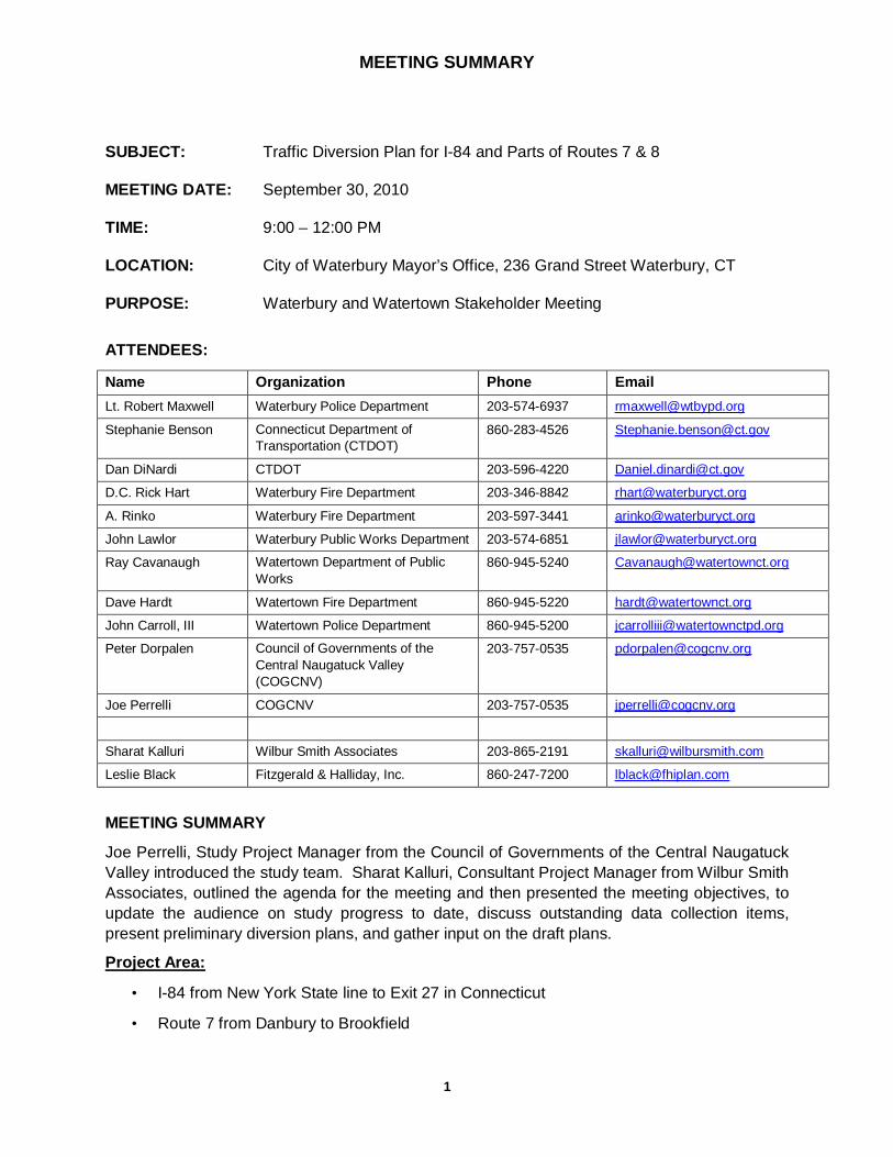
MEETING SUMMARY
1
SUBJECT: Traffic Diversion Plan for I-84 and Parts of Routes 7 & 8
MEETING DATE: September 30, 2010
TIME: 9:00 – 12:00 PM
LOCATION: City of Waterbury Mayor’s Office, 236 Grand Street Waterbury, CT
PURPOSE: Waterbury and Watertown Stakeholder Meeting
ATTENDEES:
Name Organization Phone Email
Lt. Robert Maxwell Waterbury Police Department 203-574-6937 [email protected]
Stephanie Benson Connecticut Department of
Transportation (CTDOT)
860-283-4526 [email protected]
Dan DiNardi CTDOT 203-596-4220 [email protected]
D.C. Rick Hart Waterbury Fire Department 203-346-8842 [email protected]
A. Rinko Waterbury Fire Department 203-597-3441 [email protected]
John Lawlor Waterbury Public Works Department 203-574-6851 [email protected]
Ray Cavanaugh Watertown Department of Public
Works
860-945-5240 [email protected]
Dave Hardt Watertown Fire Department 860-945-5220 [email protected]
John Carroll, III Watertown Police Department 860-945-5200 [email protected]
Peter Dorpalen Council of Governments of the
Central Naugatuck Valley
(COGCNV)
203-757-0535 [email protected]
Joe Perrelli COGCNV 203-757-0535 [email protected]
Sharat Kalluri Wilbur Smith Associates 203-865-2191 [email protected]
Leslie Black Fitzgerald & Halliday, Inc. 860-247-7200 [email protected]
MEETING SUMMARY
Joe Perrelli, Study Project Manager from the Council of Governments of the Central Naugatuck
Valley introduced the study team. Sharat Kalluri, Consultant Project Manager from Wilbur Smith
Associates, outlined the agenda for the meeting and then presented the meeting objectives, to
update the audience on study progress to date, discuss outstanding data collection items,
present preliminary diversion plans, and gather input on the draft plans.
Project Area:
• I-84 from New York State line to Exit 27 in Connecticut
• Route 7 from Danbury to Brookfield

MEETING SUMMARY
2
• Route 8 from Exit 23 to Winchester
Progress to date:
Data collection task has been completed with the exception of the following items: fire hydrants
within 500 feet of limited access highways, bridge standpipes, CTDOT maintenance facilities,
gas stations, municipal public works garages, designated emergency shelters and confirmation
of contact information. The study team asked the audience to review draft maps and provide
input.
It was noted that when traffic is diverted from the highway, routes are selected based on
functional classification to optimize traffic flow and that local, residential streets are avoided.
Limited bridge clearances and one-way streets are also avoided when selecting a route.
Diversion routes are the same for cars and trucks unless there is a bridge clearance or weight
restriction issue.
Sharat Kalluri presented the draft route diversion plans. Draft plans are available for Towns to
review on the study ftp site (case sensitive). Sharat Kalluri asked for all concerned to review
maps on the ftp site and provide any further comments within the next 2 weeks by October 15th:
ftp.wilbursmith.com
Username: DEMHS
Password: DiversionPlan
These plans are intended to be implemented only when all lanes are closed one-way on the
main highway and traffic needs to be diverted from the main highway. These plans are not to
be used for partial lane closures. These maps are designed as exit-to-exit maps for closures
between two exits versus a regional closure of multiple exits. Sharat noted that Towns will be
notified of the link to the final GIS database after study completion as well as a contact for who
will be responsible for updating the database. Comments regarding draft maps were noted and
stored on smartboard maps:
Questions and Comments:
• Central signal system can be controlled by hand by police department
• Public works department will provide hard copies of final plan maps for officers’ binders
• CTDOT noted that there are seven bridge standpipes on the I-84 mixmaster overpass
roadway system, mostly on lower deck between Exits 21 and 19.
• Waterbury Fire Department will send out team to survey locations and enumerate
standpipes on Monday, October 4th. Will send report to study team.
• All gas stations are permitted by the City of Waterbury – they will send addresses of gas
stations to the study team to add to a GIS layer.
I-84 Eastbound Closure between the following Exits:
• Exit 17 to 18 – Make Country Club Road a cars-only secondary route in good weather.
• Make designate route one-way eastbound and divert local traffic to Country Club Road.

MEETING SUMMARY
3
• Bridge is a huge bottleneck
• Exit 18 to 19 – Exits 19 and 20 westbound side on lower deck are affected – two
possible diversions need to be morphed into one.
• Consider one route diversion section for whole Waterbury corridor between Exits 18 and
23 or Exits 17 and 24 – Sharat Kalluri replied that there will be several regional and
expressway-to-expressway diversion maps as part of the final plan. The Waterbury
region would be included in these maps.
• Police-monitoring at Chase Parkway and Sunnyside Avenue
• Probably will require police-monitoring at each intersection and ramps.
• Exit 19 to 20 – Use Route 8 southbound and have both cars and trucks do a U-turn at
Exit 31 on Route 8 and take Bank Street up onto I-84 eastbound.
• Consider permanent route diversion signage for that route – it will divert around the
mixmaster area.
• Sunnyside Avenue is proposed to carry through in the future as an alternate route to I-84
eastbound.
• Note clearance on Bank Street is 12’9”.
• Exit 22 to 23 – no change from proposed route
• Exit 23 to 25 – high volume area; bridge at Harpers Ferry and Plan Road would be
congested, so add police-control at that location and at Mall.
• Exit 25 to 25A – no change from proposed route; add police-monitoring
• Exit 25A – 26 – no change from proposed route; add police-monitoring at five locations
• Exit 26 – 28 – route change to Route 70 to Route 10
Route 8 Northbound Closure between the following Exits:
• Exit 29 to 30 – left turn onto Washington Street and low overhead crossing are problems
• Alternate route: North on South Main Street; turn left on South Leonard Street; turn right
and continue on South Leonard Street all the way to the highway; good for cars and
trucks
• Place police-monitoring at two 90 degree turns, on-ramp, and at Washington Street light
• Exit 30 to 31 – no change from proposed route unless a HAZMAT situation occurs
• For HAZMAT, move away from the highway; use South Main Street to I-84 westbound
• Exit 31 to 32 – no change from proposed route
• Exit 32 to 34 – primary route – turn left at Huntington; secondary route – go straight
through
• police-monitoring at all intersection lights

MEETING SUMMARY
4
• Exit 36 to 37 – no change to primary proposed route; secondary route northbound
should be Waterbury Road
• Exit 37 to 38 – if HAZMAT occurs, use Route 6 northbound; suggested police-monitoring
at six intersections
• Primary route should be Waterbury Road northbound; have police-monitoring at Route
262 end
• Secondary HAZMAT route is Route 262 westbound to Park Road to Echo Lake Road to
Route 6 northbound.
Route 8 Southbound Closure between the following Exits:
• Exit 38 to 37 – Use Waterbury Road as primary route
• Use Routes 6/262 as secondary HAZMAT route
• Exit 37 to 36 – exit at Exit 38 and use Waterbury Road is preferred route
• three police-monitoring locations suggested on smartboard maps
• Exit 36 to 35 – off at Colonial Avenue to East Aurora Street and onto Route 73
Connector
• Exit 35 to 34 – Add police-monitoring at Riverside at Freight
• Exit 34 to 33 – For HAZMAT route, turn right on West Main Street and go to Exit18 on I-
84.
• three police-monitoring locations suggested on smartboard maps
• Exit 32 to 31 – exit at Exit 34 and use same Riverside Street HAZMAT route
• three police-monitoring locations suggested on smartboard maps
• Exit 31 to 30 – continue down South Riverside Street and down by Charles Street
• HAZMAT route – take Exit 34 onto West Main Street; turn right at Meadow Street,
continue onto Bank Street to Charles Street and back on Route 8 at Exit 30
• five police-monitoring locations suggested on smartboard maps
Contact Information Updates:
• Emergency shelter locations will be provided to the study team by DEMHS as a GIS
layer
• Waterbury Police Department – 203-574-6921
• Waterbury Fire Department – 203-597-3424
• Waterbury Public Works Garage – 203-574-8261; 51 East Aurora Street
• Watertown Police Department – 860-945-5200
• Watertown Fire Department – 860-945-5220

MEETING SUMMARY
5
• Watertown Public Works Garage – 860-945-5244; 91 Burton Street
Next Steps: The study team will address comments from stakeholder meetings and make
updates to draft diversion plans. A technical advisory committee meeting will be held in mid-
November 2010 to review final plans. All towns will be notified and provided with a link to final
plans.
January 11, 2011 TRAFFIC DIVERSION PLAN FOR I-84 AND ROUTES 7 AND 8
Wilbur Smith Associates D Council of Governments of the Central Naugatuck Valley
APPENDIX D: Emergency Contact Information for Municipalities
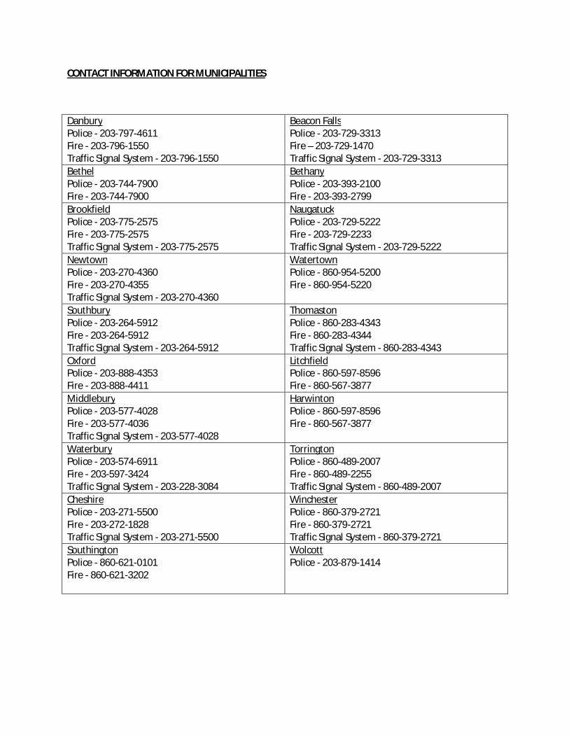
CONTACT INFORMATION FOR MUNICIPALITIES
Danbury Police - 203-797-4611 Fire - 203-796-1550 Traffic Signal System - 203-796-1550
Beacon Falls Police - 203-729-3313 Fire – 203-729-1470 Traffic Signal System - 203-729-3313
Bethel Police - 203-744-7900 Fire - 203-744-7900
Bethany Police - 203-393-2100 Fire - 203-393-2799
Brookfield Police - 203-775-2575 Fire - 203-775-2575 Traffic Signal System - 203-775-2575
Naugatuck Police - 203-729-5222 Fire - 203-729-2233 Traffic Signal System - 203-729-5222
Newtown Police - 203-270-4360 Fire - 203-270-4355 Traffic Signal System - 203-270-4360
Watertown Police - 860-954-5200 Fire - 860-954-5220
Southbury Police - 203-264-5912 Fire - 203-264-5912 Traffic Signal System - 203-264-5912
Thomaston Police - 860-283-4343 Fire - 860-283-4344 Traffic Signal System - 860-283-4343
Oxford Police - 203-888-4353 Fire - 203-888-4411
Litchfield Police - 860-597-8596 Fire - 860-567-3877
Middlebury Police - 203-577-4028 Fire - 203-577-4036 Traffic Signal System - 203-577-4028
Harwinton Police - 860-597-8596 Fire - 860-567-3877
Waterbury Police - 203-574-6911 Fire - 203-597-3424 Traffic Signal System - 203-228-3084
Torrington Police - 860-489-2007 Fire - 860-489-2255 Traffic Signal System - 860-489-2007
Cheshire Police - 203-271-5500 Fire - 203-272-1828 Traffic Signal System - 203-271-5500
Winchester Police - 860-379-2721 Fire - 860-379-2721 Traffic Signal System - 860-379-2721
Southington Police - 860-621-0101 Fire - 860-621-3202
Wolcott Police - 203-879-1414