tracking device tests · web viewaltitude tracking would be useful. the garmin etrex summit model...
TRANSCRIPT

DRAFT Balloon Tracking Tests - 2000Summary of Test Reports and Additional CommentsCompilation & comments: Alex Nagorski, Canada Test Reports by: Hans Åkerstedt, Sweden
Gerald Stürzlinger, AustriaGordon Bennett Maps: Mathijs de Bruijn February 23, 2001
A. Overview...........................................................................................................................................1B. Event Preparation..............................................................................................................................2C. Flight Set up......................................................................................................................................2D. Flight Operations..............................................................................................................................3
1. Position Transmission Times.......................................................................................................32. Information Transmitted and Implications...................................................................................33. Tracking Device Failure...............................................................................................................3
E. Providing Information.......................................................................................................................31. Reporting Medium.......................................................................................................................32. Quality of Information..................................................................................................................43. Detail information........................................................................................................................44. Web Technology..........................................................................................................................55. Observations on Test Event Web Reporting................................................................................56. Information for the Media............................................................................................................6
F. Summary of Observations................................................................................................................71. Audience.......................................................................................................................................72. Type of Information.....................................................................................................................73. Technical Benefits........................................................................................................................74. Areas Needing Further Study.......................................................................................................7
G. Conclusion........................................................................................................................................7Appendices................................................................................................................................................9Appendix 1 - Evaluation Reports..............................................................................................................9
Appendix 1(a) - 2000 Swedish Hot Air Balloon Nationals..................................................................9Appendix 1(b) - 2000 Luxembourg Hot Air Balloon Nationals.........................................................12Appendix 1(c) - 2000 World Air Games Cup, Spain..........................................................................15Appendix 1(d) - 44th Coupe Aéronautique Gordon Bennett - Belgium..............................................17
Appendix 2 - Questions and Answers Concerning Operational Use......................................................20Appendix 3 - Outlook and Demands for Tracking Systems....................................................................24
1. Americas Challenge Large Scale Map and Tracks.....................................................................262. Americas Challenge Detail Scale Map and Position..................................................................263. 44th Coupe Gordon Bennett - Day 1..........................................................................................274. 44th Coupe Gordon Bennett - Final Results...............................................................................285. Luxembourg Nationals 2000 - Test Flights................................................................................296. Swedish Nationals Aerial Photo.................................................................................................30
Appendix 4 - List of Interesting Facts and Contacts...............................................................................30
A. OverviewIn 2000 there have been a number of events testing trackers to monitor balloon positions and report them through computers and the Internet. This has not been an easy experiment due to variety of equipment, communications technology and how to practically use it in an competition setting. We thank the individuals involved for their written reports (Appendix 1) detailing their experiences, observations and
05/16/23 1 document.doc
DRAFT comments. The technical aspects of these trials should be the object of separate detailed analysis by the appropriate CIA Subcommittees,
In addition to combining all the event reports in one location, this begins the discussion of the non-technical aspects of the trials. Such as how the end result looked to a distant user: how event organisations can effectively use tracking devices: and implications of making the tracking information available to the media and public.
Thank you to all those who participated in the testing and contributed with their comments to the test reports that were prepared by Hans Åkerstedt and Gerald Stürzlinger. The initiative to use balloon tracking is focused on adding value to events for organisers, the public and media in order to promote the sport more effectively, but there are other areas such as scoring and safety which will benefit. More work is needed to carry this project forward, examine all the implications and implement it at national and international competitions. We are at the beginning of exploring new ways of making the sport more interesting and promoting it to the public, media and ballooning community.
B. Event PreparationThe implementation of balloon tracking for an event currently requires some planning to coordinate all the equipment, resources and manpower. It is essential to plan and test such items as the radio frequencies, computer programs and web reporting procedures well in advance of the event. Additionally, the advance planning may attract the attention of some communications or computer sponsorship to the event.
A balloon tracking system will require dedicated and ongoing resources and manpower to be effective, timely and usable by the public and media. At this stage of the system development it will be essential to assemble a technology and public relations team to make it work properly and keep the information flowing. Foreseeable manpower needs are in the areas of:
Equipment set up, maintenance and base station operation Communications technology Webmaster with database design and access experience Computer and network operations Officials to supervise the device allocation and collection after each flight
Some of these duties are already incorporated to a degree within larger balloon event organizations such as the worlds, but some additional resources and skills will be required.
C. Flight Set upComments from trial events suggest that once the equipment has been set up at the beginning of the event, the pre-flight effort is not extensive and can be done by observers.
All the equipment should be delivered to the assigned official or organiser who will charge all the batteries and test all the devices well in advance of any competitors arriving. Especially important is to make sure the tracking units are working on the frequencies allocated for the event.
Observer training will require working knowledge of GPS and how these devices need to be set up and verified prior to each flight. These skills can be taught to experienced observers over a span of an hour or two prior to the event. These should be hands-on training sessions where newer observers could be teamed up with someone who has some of this experience already.
05/16/23 2 document.doc
DRAFT Tracking units should be handed out prior to each flight and collected immediately after so that they can be checked for damage, charged if necessary and re-assigned to pilots the next day. This will require one individual to be responsible for the tracking units but this responsibility could be combined with maintaining and assigning operations radios (e.g. Launch Director radios) during the event
Resources required: Clear procedures from the organisers on how to handle, store and charge the tracking units One person responsible for the tracking units Observers or other officials responsible for checking, handing out and collecting tracking
units from competitors
D. Flight OperationsIn tests, the devices were turned on by the observers and did not require any handling by competitors. Maintaining this type of procedure would not distract the pilots from their normal ballooning activities and therefore should not be a problem at all for the competitors to carry them. It is important that the devices should be small, light and stored in a protective, waterproof box or bag which can be easily suspended in the balloon basket.
1. Position Transmission TimesIn hot air balloon races it would be adequate to automatically transmit the positions every minute since there will be many balloons involved. For long distance races the reporting times should be longer, especially in the Coupe Gordon Bennett where the balloons fly for 3 - 4 days and battery life is an issue.
2. Information Transmitted and ImplicationsOf primary importance is the reporting of the location of the balloon and route traveled. Altitude is not generally a concern for immediate spectators but can be important and useful to event officials. Caution will need to be exercised as release of altitude information could be retransmitted to the competitors very quickly and may affect their strategies especially in long distance ballooning.
3. Tracking Device FailureThis may result from battery, electronic or software failure, or the topography of the flying area, but efforts need to be made to make the tracking devices very reliable and insure that communications are not interrupted.
E. Providing InformationReal time tracking, broadcasting and web information is valuable to those on site or within the immediate community since they are aware of the activities in the sky, but we want to bring that closer to them. Put them right into the whole experience. Generally the results and tracks of the competitors would be of greater importance to distant watchers than watching it in real time.
Although there should be a standard set of information for most events, some like the Coupe Gordon Bennett will have additional or different information from the hot air events. Factors such as audience (public, media, balloonists, etc.), broadcast requirements and language, need to be considered but in combination with resources available by the host organisation.
1. Reporting MediumCurrently most air sports are not considered as sports by the broadcast media, rather they are still perceived as part of the news segment, and as an example of a unique event. Although efforts are underway by the FAI to promote all air sports through TV broadcasts, the ballooning community also
05/16/23 3 document.doc

DRAFT needs to make efforts in this direction. Television media are not the easiest to work with since they want the good photographs, graphics and clear results.
The Internet and Web offers an opportunity for balloonists to control how their sport, events and results are portrayed. They can control and update the pertinent web sites, promote their athletes and sponsors, and provide additional, more comprehensive information that would not otherwise be available to the public and media. Additionally, through email and mailing lists, key information can be sent out regularly to interested parties, which would then encourage them to go to the web site for detail information.
2. Quality of InformationTo attract and keep people coming back to the web sites a number of key elements must be planned for during the event:a) Information must be current and timely which means it must be regularly updated with event status
such as weather, flight status and results. If a flight is cancelled, that should be immediately posted.b) The information needs to be understandable by the public and no just balloonists. Graphic images are
more easily understood than the written word, especially considering the various languages. Maps, photographs, and graphical representations should all be used.
c) Information should be meaningful. Visually, although an exact location on an aerial photo is interesting, it is more meaningful to see the location in combination with the actual track of the balloon. And even more meaningful if the location of the marker is displayed in relation to other results.
d) Position or results in relationship to others provides a better overall picture to the spectator than just one balloon. An good example is the 44th Coupe Gordon Bennett where the track and final landing of the winners is very interesting but when displayed with the track and landing places of other competitors it becomes a truly remarkable flight by the winning team.
e) Using web tools and links, value added information can easily be provided, if it has been collected and available. This can include: pictures of pilots, balloons, biographical data and previous competition results. This information would be useful for media interviews and stories of the top pilots or to local media in the competitors home town.
Collection and presentation of information is not difficult using tracking devices, data transmission, communications software and graphical display software and devices. The key is to find the right combination, individuals to use it and the resources to keep it all working throughout the event.
3. Detail informationUsing the Web and database technology information can be captured, retained and displayed in a timely manner and in number of different views which would enhance the event and competitors images. Some of the information could be:
a) Scoring Current ranking of competitors (top down sequence). This is very useful in a race like the
Gordon Bennett where people have landed while others continue to fly for several days. Task, flight and overall score in ranking sequence
b) Biographical information on competitors Pictures of pilots (portrait and action) but using smaller images Historical results in competitions Personal information Opinions on competition, etc.
c) Balloon images and information
05/16/23 4 document.doc
DRAFT Pictures of competitors balloons Information on each balloon (eg. manufacturer, size, etc.) Links to manufacturer sites
d) Tracking information Flight track for each flight Show track of balloons, not just current position. Current position is meaningful if you are
watching the event in real time. Such as at the event launch field or officials area. At any point after the flight the zoomed in location is not meaningful as a person does not have the benefit of the information on how the pilot achieved his current position. When looking at the event from other parts of the world; unless you are watching it live, the only meaningful information would be the track of the balloons and marker results.
Display balloon numbers and pilot names with links to other information Location of targets and results Reasonable scale maps starting with optional large scale maps of country and area. Only show one map at a time and let user select if they want to see more detail maps. Zoom-in capability on maps to isolate each balloon and pick up more detail,
e) Competition information Task sheets Weather information
Care needs to be taken to make this information easy to access, meaningful and to be understood by any non-balloonists or media person.
4. Web TechnologyThe Web pages should be informative but quick to download and display on computers using modems. Do not rely on fast Internet connections, yet.
There are a number of very good programs, tools and plug-ins that can make a Web site very attractive and informative, but caution needs to be exercised when asking the end user who is looking at the Web site to download plug-ins or install additional programs. A dedicated balloonist may do that, but any new users will immediately leave the site.
If possible, it is recommended that visitors to the event Web site have the option of simply browsing the basic information and if they want to fully experience the event then they can select to download and install plug-ins or programs. That way the casual or new user still controls what is installed on their computer, does not have to wait for the download and installation and is not turned off immediately.
5. Observations on Test Event Web Reportinga) Swedish Nationals 2000
Good web reporting Database produced results for each task in ranking sequence Reasonable task sheet for user information Good maps and ability to zoom in. Most detail information was displayed on an aerial photo
with location of balloon marked, but would have been more interesting to also display the track.
Need to display balloon numbers and pilot names on same page as map. Good idea of clicking on the balloon and getting pilot information but a bit awkward to do so
when many balloons in close proximately. Do not use frames for the web pages as they sometimes get stuck and part of page is not
displayed
05/16/23 5 document.doc
DRAFT Full screen images are good but no controls or indication on how to maneuver from there. Some balloon photos too large and take too long to download Results were a bit confusing and it is suggested that the number of options be reduced.
b) America's Challenge Nice to see large scale maps of balloons and have the ability to zoom in closer right down to
street name. Tracks of balloons on larger scale maps were great to get a relative position Had the ability to show track and current position of a single balloon
c) 44th Coupe Aéronautique Gordon Bennett Overall a very good effort to show this great event for the first time Was very good to see the track and reporting points of all competitors. Need to slice up reporting into smaller pieces and maps for quicker access Have a separate page for each reporting period (e.g. day or morning/evening) Competitors need to report regularly - eg: every 4 or 6 hours with that information updated by
the Operations Team onto the Web as soon as possible. Need to use more detail maps possibly with zoom capabilities The results should be presented on the primary event Web site so that organisers, community
and sponsors realize the maximum exposure to people visiting their site.
6. Information for the MediaProviding meaningful information to the media is critical so they can then do their job of reporting on the event which in turn attracts more spectators and subsequent sponsorship interest. If the media's job is easier then there will be more coverage for the event. So suggestions for the press, Air Sport International and public releases are:
Description and comments on the host country, city and flying area (articles will be published world wide so take advantage of publicity)
Weather conditions encountered during the event Noteworthy tasks or achievements during the flight List of top ten finishers and their cumulative scores Human interest aspects:
- Paragraph or two about the winner- Rivalries old and new- Happy competitors, winners, officials, organizers, sponsors, etc.
Good quality and interesting pictures - lots of them- Preferably in digital format (from digital camera or scanned) so they could be downloaded
quickly- balloons, people, target approaches, scenic pictures, etc. - Select pictures to be published on the CIA Web site so they should be free to use without
restriction and copyrights, although photographers name should be acknowledged.
Focusing on information for the media also provides it for the public and the rest of the ballooning community, thereby providing an opportunity to promote the sport, the event and the host community.
F. Summary of ObservationsThe testing of tracking devices resulted in some interesting information and variations being provided via the event Web sites. With the wide range of information available it is important to keep in mind why balloon tracking should be used.
05/16/23 6 document.doc
DRAFT 1. Audience
The needs of each group vary and their perspective of the information will be different Spectators - those on site to provide them the complete ballooning experience.
- those further away who want to experience it and learn the results Media - to provide information so they can in turn publish results, information on competitors,
and hosting organisations Ballooning community - to experience the events and encourage them to attend next time. Officials - to monitor the event, safety and quickly provide results Organisers - to attract additional sponsorship and promote their event and community Sponsors - to receive wider exposure for their financial support Potential new balloonists - to attract more people to the sport
2. Type of InformationThis has been discussed previously but needs to be emphasised that information must be presented in a meaningful and understandable manner to the various groups that would be interested in it. This will require further study and evaluations from more events.
Knowing the physical position of the balloon would provide enough information to create graphical displays of track and location of other balloons. This would be adequate for most public, media and web applications but the need for 3D images will soon emerge, especially if combined with the ability to display sponsors balloons, logos, etc.
3. Technical BenefitsBesides the focus on publicity, the tracking devices proved to be useful in helping score some tasks, finding lost markers and were a safety aid for long distance races. Other than the initial communications and computer set up they were relatively easy to work with, and for some events they were incorporated with the event Observer duties.
4. Areas Needing Further Study The tests also raised a number of questions that need to be addressed by various CIA Subcommittees. Questions such as: Are there any implications on the current rules and do they need detail review? What event policies, rules and guidelines need to be changed? Should the ballooning community be purchasing the equipment or can the commercial companies
be recruited as sponsors? Should satellite tracking be investigated, and although more expensive may have more potential
for sponsorship from these large corporations? How and where can real time tracking information be displayed to gain the most exposure for the
sport? How are other air sports progressing in their testing of tracking devices and projected uses?
G. ConclusionThe first tests of tracking devices have identified problems as well as some very real benefits to the sport. These tests were just a start. To implement a comprehensive program of using tracking devices there is a need to form a team to take this project to the next level and to establish the structure and procedures at events so they can be used easily and effectively.
The implementation team should consist of individuals with the following skills: Technical expertise in GPS and communications Computer expertise to collect the transmitted data, feed a database and feed the Internet
05/16/23 7 document.doc

DRAFT Competition skills to monitor affects on pilots, crews, etc Competition officials to see how information can be used by officiating team Public relations and media expertise to see how information should reach the public Event organiser skills to measure impact on events, sponsors, etc.
The ballooning community has started an interesting project that allows the sport to explore new ways to promote itself and encourage growth. These efforts should continue.
05/16/23 8 document.doc

DRAFT
Appendices
Appendix 1 - Evaluation Reports
Appendix 1(a) - 2000 Swedish Hot Air Balloon Nationals Evaluation of GPS tracking systemKatrineholm, Sweden, June 2000By: Hans Åkerstedt
Purpose:The test had three main purposes1. To design and build a tracking system for the Fire and Rescue authorities of Katrineholm city.2. To use a tracking system and display the movements of balloons during the Swedish Nationals on
web site for PR purposes.3. To use GPS measurements for competition purposes.
History:At the end of 1999 we started to look for hardware for a tracking system, mainly for use between balloon and retrieve car for competitions 2000. At the 2000 CIA meeting a system that had been used in gliding competitions was demonstrated. During our study we found that there were other systems or components commercially available that might satisfy our needs. Those systems were less expensive than the system demonstrated to us. We decided to make a test at the Swedish Nationals in Katrineholm, Sweden beginning of June. By coincidence we found that the City Council had decided to evaluate a tracking system for use by the Fire and Rescue service and wanted a test with 12 mobile units. Jan Balkedal undertook to design the units and make the test. The Swedish Balloon Federation approved the use of the tracking system and planned to obtain a further 6 units. In the end only the 12 units owned by the City Council were available.
Equipment:The system designed by Jan Balkedal consisted of the following components.Mobile units1. Kenwood TH-D7E dual band FM radio. Power output 5W.2. Garmin 12 GPS3. Sunrise 12 V, 7 Ah lead/gel rechargeable battery4. Voltage divider for the GPS5. Carrying bag, integral padding with carrying handles.Total weight 4 kg. Bag size 35x20x15 cm. (could have been about half that size)Base unitA base radio operated by City Council. Antenna at top of City Hall.
Costs:The costs for each mobile unit is about 9 000 SEK (EUR 900) including 25% Swedish VAT.A Base station would cost about 12 000 SEK including antenna.Program software for radios and map interface, total about 5 000 SEK.Development costs about 100 man-hours.
Personnel:Development:Jan Balkedal, project manager
05/16/23 9 document.doc
DRAFT Artur Zonabend and Olle Tillberg, GPS-radio interactionFredrik Elestedt and Victor Lindberg, web designJoar Andersson, City Council webmasterAnders Lindbäck, Metria, mapsTobias Kärrsten and Hans Åkerstedt, research and specifications.
OperationGeneral.The web designers loaded competition data to the web. The webmaster at the City Council decided how to use the data coming in from the mobile units. During the competition the mobile units were maintained by Hans Åkerstedt and handled by the competition observers.
The position data was updated from the mobile units with an interval of 60 seconds. The positions were stored in a database and transferred to the web map. The map was a 1:50000 topographical map (same as used for the 1998 European championships). Only the last received position from each unit was displayed together with pilot identification. The transmitters were programmed to send competition number and pilot names.
The balloon positions could be updated at any time to show all balloons last reported position. The maps on the web were scaleable down to Ortophoto. It is possible to program the system to show more information such as continuous track for each balloon, altitude and speed.
The information on the web was in English to make it more understandable for our foreign readers. The City Council remarked that the information was too much oriented towards a ballooning audience and they had preferred a Swedish version for better PR effect.
The web site was also used by the Event Director and other competition officials to follow the process. It was noted that one team usually stopped at the local hamburger place before returning the observer. There may be a conflict with laws about personal integrity.
Before the eventEach mobile unit was fully charged and each radio was programmed to transmit competition number and pilot name. The transmit frequency and transmit rate was programmed and all parameters were loaded via the software from a PC. Each GPS was set to WGS 84 and to display the local grid. WGS 84 because most map programs need this and then make better calculations than a GPS. Local grid to make it handy for the observer.
Most observers had very little knowledge in the operation of GPS equipment. There was therefore a 30-minute briefing and hands on training. The observers then could operate the system and take and store GPS positions. All marker drops more than 100 meters from a goal or target were recorded.
During the event:Only the GPS part was used as a tool for the competition. One person was responsible for charging, setting and safekeeping. He also handed out and retrieved the units before and after each flight.
We had 14 competing pilots but only 12 complete units. The units were used by the top 12 pilots on the Swedish ranking list. The two remaining pilots only had a GPS for position measurements.
The large capacity battery required only one charging cycle during the event (3 flights). The units operated about 5 hours each flight and transmitted a few seconds each minute. The GPS was also operated from the external battery. The internal battery in the radio should last for 8 hours and the GPS
05/16/23 10 document.doc
DRAFT for 24 hours. Theoretically we have 60 hours for our units. In a test we have run a unit 24 hours transmitting each 10 seconds with 5 W.
Before each flight the units were switched on shortly before the observer briefing. The units had to be switched on at about 5 second intervals to ensure that they transmitted at correct intervals and to ensure that all transmitted once each minute. The precise transmit time can be programmed using GPS time but this possibility was not used.
Before the first flight also the GPS units were switched on. The Garmin 12 unfortunately switches itself off after some time if no satellite signal is received. This of course happened during the briefing for most of the units. Some were checked before flight and switched on by the observer but about half of the units did not operate during the first flight of the event.
For the subsequent flights all GPS units were switched on by the observers shortly before each flight.
Before start of each flight all units were handed over to the pilots. Also the two single GPS were handed over to the pilots as the observers could otherwise use them on ground during the flight. As the other observers did not have that possibility we wanted all to have the same conditions.
After landing the observers took care of all units and used the GPS to record all relevant positions. The positions were recorded on the observer reports and stored in the GPS.
Before debriefing all stored positions were checked against those written down on the observers report. Thereafter all units were switched off and stored. All positions remained stored in the GPS units in case they were needed later.
Apart from the first flight there was no equipment problems and all worked as planned.
Summary of GPS measurements for each taskTask no Task name Number of markers measured by GPS
1: Fly in 12: Fly on 43: Min Dist 14 (all)4: CRAT None5: Min Dist Double Drop 20 (all inside valid limits, some lost)6: PDG 87: Fly on 108: Fly on 89: Max Dist Double Drop 20 (all inside valid limits, some lost)
In addition to marker position recording also the distances for task 5 and 9 could be measured, as the co-ordinates were stored. With this facility a provisional list of results could be made as soon as the observer returned for debriefing.
Also start and landing positions were recorded on each GPS.The use of GPS greatly sped up marker measurements and debriefing. It was also successfully used to search for lost markers as some pilots had stored the positions where they dropped markers. [email protected]
_________________________________
05/16/23 11 document.doc
DRAFT Appendix 1(b) - 2000 Luxembourg Hot Air Balloon Nationals Experiences from the FlyTrack Demonstrationby Gerald Stürzlinger, Austria ([email protected])
A System for Tracking & Visualisation of Aircraftsusing airborne GPS combined with Radio Transmittersdemonstrated at the Luxembourg Hot Air Balloon Nationals 2000held in Larochette, Luxembourg from 10th to 12th June, 2000
Note:This story is partly in a narrative style, the technical facts are summarized further down. At the end there is an outlook, of how such a system should be designed (or modified) to be useful for ballooning.
The purpose was to evaluate the FlyTrack System from Intelis, Parma for suitability for hot air balloon events. The FlyTrack System was successfully used at some gliders events, a small demonstration video at the CIA conference in March initiated the interest for ballooning events.
Pilot Gerald Stürzlinger from Austria offered to donate a startup-package of ten devices to push the early use of such a system within the Ballooning community. A group of interested people conferred about several aspects of these tracking systems via email. The developers of the FlyTrack system were asked to give a life demonstration at the Luxembourg Nationals 2000 at Larochette.
The basic FlyTrack system works like this (simplified):
Hardware Side : The airborne GPS generates a position report (in NMEA-"Format" on the serial port) every 60
seconds, a TNC (simply called "radio modem") converts this to tones and a radio is transmitting these "packet" of position information down to a base station. The base station converts these "tones" back to serial output and feeds all position reports (from many tracking devices) to the computer.
Software-Side:The FlyTrack Software reads all these position reports with identifiers, stores them into a database
and allows instant visualization (2-d) overlaying a digital map. Furthermore, the FlyTrack Software has an export feature to produce 3-dimensional models of the movements of the balloons (with tracking devices). These 3D Models are described in a specific language (Virtual Reality Markup Language = VRML), enabling all Web-Browsers with a VRML Plug-In (cosmo-Player recommended) to view these 3D scenarios. This special output (VRML-Model World) of the FlyTrack Software can be published live on a Web-Site for interested Internet-Consumers.
The Equipment and the Setup at Larochette, Luxembourg:
Paolo Nadotti and Daniele Barezzi (from Intelis, Parma, Italy) brought the following components of FlyTrack:Mobile Tracking devices : 3 hardware units: FlyTrack transmitter radios (size: approx. 10x5x20 cm) 3 GPS systems (a Garmin 35 "mouse", Garmin 90, Garmin 12) with cablesThe Base Station consisted of: One radio (same size as transmitters) with a long antenna (approx. 2,5 m) One Digipeater (digital repeater): this is a special radio to relay the position reports from the tracking
devices to the base station (to extend the range of the radio system) One powerful computer to do all the processing (for visualization) with FlyTrack Software installed The internet-connection and some Web-Space for the results.
05/16/23 12 document.doc
DRAFT
The Setup of the experimental base station took about 3 hours (two people), the Digipeater was set up on the next day (approx. 4 hours). This was needed, since the base station was located on the base of the valley (pun unintended) and signals from the tracking devices would not reach into the valley. Finding the right place for the Digipeater took most of the time. By the way: The castle of Larochette proved to be a nice location for that purpose.Lesson for the future: Setting up the receiving stations and the Digipeaters should be planned ahead according to the landscape (the morphology), taking hills and valleys into account.
The set-up for publishing the results on the internet was done with help from Jean Klein, Luxembourg. Jean offered us some space on balloon.lu, where we could upload (FTP) the resulting 3D-model files from the tracking. Jean also established the links from the main pages to a small menu page, where the surfer could select a scenario for viewing. A small part of this web-work was done after the event, since Jean was also participating at the nationals.See: http://www.balloon.lu/lux2000/links/Flytrack/index.html
Other preparation before the event: The FlyTrack transmitters work on a fixed frequency, permissions to use that frequency in Luxembourg needed to be obtained (Alain Neunes, Luxembourg did his best to get that done within a few days).
We also needed the scanned / digital Maps of the competition area. ( Marc Rosenfeld and Weber Claude helped to obtain these ). Some time was needed to calibrate these maps for use in FlyTrack.
Operating the devices:The Flytrack hardware units were preprogrammed, they have only a power switch, an antenna (with
a meter of cable), a 9-pin RS232 connector for the connection to the GPS.The pilots had to switch the unit on some minutes before the take off and take them onboard. If they
had the version with the Garmin 12, or 90 (or similar), they also had to power up the GPS; the Garmin 35 (looks like a mouse) has an external power supply and is switched from the FlyTrack unit.
Right after the early installation of the base station, the test pilot (Gerald) took one of the transmitting units and made a test flight. This test run of the FlyTrack system was successfully completed, the chase crew and the base operators (Paolo, Daniele, Alain, Jean) could watch the movement of the balloon on the screen - at one time they also saw the balloon passing outside their windows - in reality ! (see file "teststuerzl.wrl" following the above mentioned link on balloon.lu)
During the first competition flight three competitors took the units on board, but not enough tracking information could be received and recorded at the base station. Even the second flight proved unsuccessful for testing, first we thought because of the distance from the base station (some 20km away).
Later we found out, that the fixed frequency (464.500 Mhz) the transmitters were using was blocked (occupied) by a different, unknown radio transmission (only the "bare" transmitter could be sensed, no audible modulation). From the process of gaining a permission to use this frequency we had the information that an older cellular-phone system from Germany ("C-Netz") could be using that frequency, but we didn't know that there would be a constant transmission on that frequency - essentially covering all FlyTrack transmission that were some kilometres from the base station.
Lesson: Check before the event and use legally available, unblocked / unused frequencies, use radios or a radio-network with alternative frequencies (in case one is blocked); use more digipeaters.
To produce some more results for the review of the 3d-models, we took three GPS recorded flights (2d) and added manually some guessed/estimated altitude information. These "enhanced" flights can be viewed as movies on the web (see link above), only one balloon in one file. The FlyTrack software allows
05/16/23 13 document.doc

DRAFT to produce a snapshot of a scenery with more flying objects: the file: JDG_snapshot.wrl shows three balloon approaching the JDG-Target, all lined up for the descent. This snapshot is a "frozen" picture, a still-frame, it can be viewed from different angles to get a good view of the scenario at the target.
Lesson: Improve the FlyTrack software: better map detail near the viewpoint, improve the accuracy of the 3-d modell (should be able to exactly match map co-ordinates), improve to display more balloons in a VRML-movie.
Aftermath of the Larochette Experience:We learned much about the tracking system and could therefore suggest and make improvements for
a future system. I have to thank all participating enthusiast, especially Paolo Nadotti and Danielle Barezzi (FlyTack developers) for coming the 8 hour trip from Parma, Italy, to demonstrate the System.
The developers of FlyTrack agreed that the development of their "home-built" FlyTrack Hardware devices was overrun by commercial companies. They do not want to reinvent the wheel, if a better alternative is easily (and cheaper) available. Also the flexibility with the used frequencies (and some legal restrictions) is a strong point in this matter.
The Kennwood TH-D7 could be this radio, it has the TNC built in and is ready to plug the GPS into it, it is designed to transmit these position information in packets. Using this radio would solve a lot of the problems we conquered in Larochette.
Still we would need to "scout" the competition area before the event for good places to put up DigiPeaters, especially if the terrain consist of some deep valleys where radio signals could not propagate easily. Also some testing of the equipment before the event would be useful. If there is already an existing infrastructure of DigiPeaters built by radio amateurs that we can use we have a better start.
Uwe Schneider also suggested the possibility to use some cars (with powerful radios) as moving digipeaters. If you take some chase-cars equipped with Kenwood's TM-D700 (50 Watt), then you would have perfect coverage near the "happening", right next to the balloons.
The Kenwood radios are built to military standards (rugged, splash-water proof), but some housing / some cover to make it a "black box" unit was suggested. There is a key-lock function (even computer-programmable) that avoids any later accidentally unwanted key-input from the user. A little case that blocks the keys physically would be the better protection for these devices.
For the FlyTrack Software we brainstormed some improvements that would help the acceptance for ballooning purposes. First the developers would need to make the input compatible with the (Kennwood) APRS Protocol and Sentences. For the visualisation there are some points:
Allow multiple tracked balloons in the VRML-movies. Enhance the display of the balloon (suggested to place a "virtual string" under each balloon to be able to see the ground track), paint the ground track in different colors.
For the VRML-Models we have to find a better compromise - if one wants more map detail the download of the model and the display would be much slower for modem connections and slower on weaker machines. One could publish 2 versions on the web: a simple model for quick and easy viewing, a special full-featured high-resolution-model for power-users, that can handle more download and have the computational power for better graphics.
(Caution: technical detail): The VRML built in limit of 1024x1024 pixels for a bit-map texture could be overcome by splitting the map into 4 parts. Since only parts of the competition map will be used during a flight, only these parts over-flown would need to be made in a better resolution. We could use a basic map (low resolution) and put some higher-resolutions bitmaps literally over the interesting parts where the balloons fly or have flown.
Another improvement for the 3d-translation: We found some positions to be offset from the displayed positions in the 3d-VRML model. This would need to be made more accurate.
05/16/23 14 document.doc
DRAFT When viewing the 3d-models with the Web-browser Plug in, you can already choose your viewpoint.
Starting and stopping the movie (lets say, VCR-like control) would be another nice feature. Selecting a group of viewed balloons (objects) could be useful, if we have more than 20 balloons tracking - selecting the displayed size would also make sense for more balloons on screen.
For the Organisational & Operational matters we learned that you would need two to three people in setting up the system during half a day. Persons with "local" knowledge of the operation center, city and which persons to contact for special needs proved to be very helpful. One webmaster or other computer guy should be in reach for connecting and setting up the web-links. One radio amateur could be assisting in setting up the antennas, digipeaters and such.
The operation of the base station would only need one person, maybe two in shifts or one instructor and one student. The tracking devices could be handed out to the pilots like the markers, the only need to be switched on in a synchronized way. After the flight or after every other flight the devices would be returned at the headquarter and then recharged / or the batteries replaced.
Technical aspects summarised: 3 FlyTrack airborne Transmitters with a GPS connected, antenna rod on extension cable in a self
contained "black box" with built in Radio, TNC, battery. connectors and power switch on top. Base station: FlyTrack Receiver with RS232-serial output to be fed to the PC, a high gain antenna or
a directional antenna (if a DigiPeater station is used). DigiPeater to stretch the reach of the radio signals, receives packets and transmits (relays) them to the
base station. Pentium 500 (or better) PC with a better graphic card, preferable a 17" or 21" Monitor with a
resolution of 1200x1024 or more. FlyTrack Software version 2.0 to record and display the received positions of the tracking devices on
top of a digital map, ability to produce a 3d-model in VRML for publishing the movements life on the WEB.
Costs (from earlier quotes from Nadotti):
FlyTrack airborne transmitter 800 EuroBase Station 1.000 Euro with special antennasDigpeater Stations 800 EuroSoftware (FlyTrac V2.0) 1.500 Euro unlimited number of tracking devicesField assistance by developer 300 Euro per person per dayDevelopment costs not estimated
_________________________________
Appendix 1(c) - 2000 World Air Games Cup, Spain New experiments - new ExperiencesBy: Gerald Stürzlinger
The World Air Games Cup 2000 (aka the Pre-World Air Games) held near Sevilla, Andalusia, Spain this July provided another opportunity to do a test run of some new equipment for Tracking. [ The amateur radios with a built-in TNC (radio modem) were already used by the Swedish group, but for me it was the first hand-on experience.]
Although I was participating in this event, I could successfully distract myself enough to set up and operate a small tracking system. The system components:
05/16/23 15 document.doc

DRAFT A Kenwood TM-D700 in my chase car connected to a laptop computer running WinAPRS software as a moving base station.
Up to five Kenwood TH-D7 units as "Trackers", each connected to the Pilots GPS units. (additionally to my three TH-D7 we used one from Schneider, one was borrowed from Rosenfeld - Thanks)
The APRS (automatic position report system) we were using was developed by Bob Bruninga, details see : http://web.usna.navy.mil/~bruninga/aprs.html or also http://home1.gte.net/scout/aprs3.htm
The basic principle is: the radios converts the GPS (nmea-format) position information into an APRS-packet that can be sent between radio stations (even distributed via a radio network). The receiving end or the base station converts these "tones" back to information on a serial port, whichcan then be used to display updated positions of the trackers.
The radios were programmed to send the pilots name as the call-sign, thus the symbols and the tracks displayed on the WinAPRS screen could be directly recognised as from which team the position reports were received.
The radios were set to a 30 seconds transmitting cycle, luckily the Kenwoods have a "collision detection" for the transmitted Packets built in, so we didn't need any synchronizing, the units will find a free slot for themselves. This makes earlier thoughts of methods to synchronize the radios obsolete.
See technical note at the end for further thoughts about time slots.
In Spain we used a fixed frequency, that was apparently "available", I have to admit that for this small test we didn't bother to ask for a "free" frequency (like in Luxembourg) ......
I distributed the radios during the roll-call of the briefing, for this test run always to the same pilots.
After some early problems (stable rs232 connection in the car, enough battery for the laptop, (key-) locking the radios to avoid unwanted channel or frequency changes, setting the GPS units to NMEA output, and the like), I was able to successfully record the last two flights of the competition.
The tracking was done live, in theory my crew could watch the movements of the balloons - but I kept them too busy chasing me and my markers, so the output and the recorded tracks were mostly viewed after the flights.
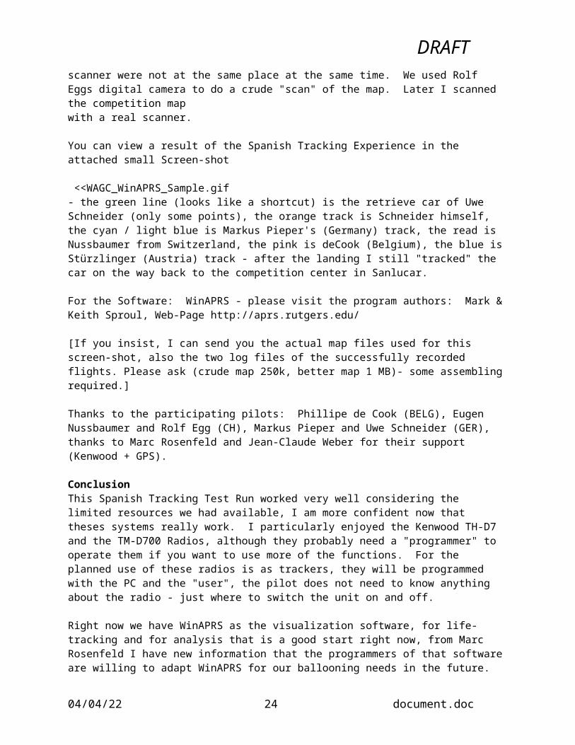
The scanning of the map to be used as a background for the displaying software was another tricky part, since the competition map and my scanner were not at the same place at the same time. We used Rolf Eggs digital camera to do a crude "scan" of the map. Later I scanned the competition mapwith a real scanner.
You can view a result of the Spanish Tracking Experience in the attached small Screen-shot
<<WAGC_WinAPRS_Sample.gif- the green line (looks like a shortcut) is the retrieve car of Uwe Schneider (only some points), the orange track is Schneider himself, the cyan / light blue is Markus Pieper's (Germany) track, the read is Nussbaumer from Switzerland, the pink is deCook (Belgium), the blue is Stürzlinger (Austria) track - after the landing I still "tracked" the car on the way back to the competition center in Sanlucar.
05/16/23 16 document.doc

DRAFT For the Software: WinAPRS - please visit the program authors: Mark & Keith Sproul, Web-Page http://aprs.rutgers.edu/
[If you insist, I can send you the actual map files used for this screen-shot, also the two log files of the successfully recorded flights. Please ask (crude map 250k, better map 1 MB)- some assembling required.]
Thanks to the participating pilots: Phillipe de Cook (BELG), Eugen Nussbaumer and Rolf Egg (CH), Markus Pieper and Uwe Schneider (GER), thanks to Marc Rosenfeld and Jean-Claude Weber for their support (Kenwood + GPS).
ConclusionThis Spanish Tracking Test Run worked very well considering the limited resources we had available, I am more confident now that theses systems really work. I particularly enjoyed the Kenwood TH-D7 and the TM-D700 Radios, although they probably need a "programmer" to operate them if you want to use more of the functions. For the planned use of these radios is as trackers, they will be programmed with the PC and the "user", the pilot does not need to know anything about the radio - just where to switch the unit on and off.
Right now we have WinAPRS as the visualization software, for life-tracking and for analysis that is a good start right now, from Marc Rosenfeld I have new information that the programmers of that software are willing to adapt WinAPRS for our ballooning needs in the future.
The other system we tested in Larochette, Luxembourg earlier this year had promising software for 3d-display: FlyTrack from Intelis, Parma, Italy. The developers will need to adapt the software for more open standards, like the APRS system. We will keep this as an option for the future, as timewas too short to modify or update the software before August. - The result of our test run from Luxembourg can be viewed at: http://www.balloon.lu/lux2000/links/Flytrack/index.html
I am looking forward to the next real installations (after enough test runs) of these tracking & visualisation systems, Marc Rosenfeld and his crew will set up a WinAPRS based system with an APRS network to do the tracking in Bourscheid, at the MobiLux Trophy starting on 28th of July.
If you want to watch us flying, first you will need to download WinAPRS and the competition map (once), you will then be able to use WinAPRS for the live tracking. [more info to follow, this is just a quick summary of what Marc told me].
Thanks again to all the supporters of these ideas, See you soon in Luxembourg or read/write me soon. Gerald Stürzlinger
_________________________________
Appendix 1(d) - 44th Coupe Aéronautique Gordon Bennett - Belgium From Competitor debriefing recorded by Hans ÅkerstedtEurospace Centre, Transinne, Belgium, September 16th, 2000
Present: Competition officials including Event Director, Jury, 14 out of 17 competitors and other interested parties.
1. Use of tracking devices as a substitute for observersAll in favour but a negative effect is that for many, observer work is a good way to get to know the Gordon Bennett way of ballooning and this possibility is lost.
05/16/23 17 document.doc
DRAFT 2. Reliability of tracking devices and possible improvements
Only one equipment failed. Tracking stopped after about half the flight. Reason unknown but may have been caused by interference from other onboard electronics. Track from competitor GPS used as a substitute.
Interference from some GPS (Garmin 195) to some VHF radios (Dittel) is a known problem and will be investigated.
The bag could be attached higher (than in the load ring) but first the influence on the hydrogen gas has to be checked. If it had been suspended higher the crew in the balloon that ditched could not have saved the tracking device.
Altitude tracking would be useful. The Garmin Etrex Summit model has a built in barometric altimeter but the track log in not usable for long flights. Future models may satisfy our needs.
Next generation equipment may be smaller and lighter. The system used this time was contained in a 25 cm high bag and total weight was 2,8 kg.
Satellite tracking systems are at the moment too expensive.
3. Live reporting on Internet and its effect on the goals of the Coupe Gordon Bennett It was generally accepted that live tracking would be very attractive for sponsors, media, the
general public and balloonists around the world. Especially the Gordon Bennett race with its simple rules and long duration is well suited for displaying the tracking on Internet but it should be kept simple.
The display on the web should be updated regularly to keep it interesting. Some were afraid that real time tracking was in conflict with the traditions of the race while
others welcomed the development. Any income generated should also be beneficial to the competitors. It should be used to reduce
entry fees or similar. Real time live tracking will have an effect on competitors strategy especially at the end of the
race. A flexible time delay could be used towards the end. Other means to modify the “live show” should be investigated to make tracking display acceptable to the majority of the competitors. Participants well in advance of the race should know the method used.
In the 2000 GB the Event Director delayed the publication of results but even so the last balloon flying might have had an advantage. The Director apologized but the pilots of the last balloon stated that the knowledge of approximate results did not influence their strategy as they regarded the information as unreliable anyhow.
4. Practical rules for organisers to establish the competition area. All agreed that it is too late to make a decision at the General Briefing. Officials and
competitors have to prepare long in advance with entry permissions and visa. It was accepted that all countries in question including Belarus and Ukraine were safe to fly in
but the main problem was safety for the retrieve.
5. Review of the 44th Gordon Bennett race and its organisation The presentation of the weather information was difficult to follow. Display on a screen would
have helped. The location of a bar for the public in the briefing tent was not acceptable. The parking of retrieve cars far away during inflation was not acceptable. Some VIPs were
allowed to park inside the restricted area but retrieve cars with all equipment had to be parked at a remote spot.
The above issues were planned otherwise but changes were made without consulting the Director.
The rules regarding some airspace restrictions were not made totally clear to everyone. Different officials gave conflicting messages. A verbal complaint was made as a result but in
05/16/23 18 document.doc

DRAFT the end all agreed that the competition was fair and the results were derived in the spirit of the Gordon Bennett race.
6. Any other issue and future improvements Some wanted detailed penalty rules but the majority agreed the rules should be kept simple. It should be added in the rules that matter of Air Traffic Regulations is an issue between the
pilots and appropriate ATC units. The 48-hour limit to bring back tracking equipment should be modified. In this race the last
crew in the air had to ship the device back (including 2.5 kg lead battery) by express mail at great cost. Then it was discovered that the tracking had failed after half the flight.
Some pilots wanted the possibility to spend a few hours sightseeing on the way back from countries they had not visited before.
It was proposed to postpone the prize ceremony until the next year to give more time for evaluation of results. It had been tried but was not considered successful from the social viewpoint. An event should end with a proper banquet and lots of storytelling.
Proposal to slip one year to get more time for organisation of the event was discussed. The winning nation would organise the event 2 years later.
The CIA/FAI should more actively support the organisation for instance with entry permissions for balloons and retrieve crew. The CIA could also translate some information like witness reports and information to Border Control to languages that are foreign to competitors. That would include also languages like German and French, as all pilots are not fluent in these.
For a Gordon Bennett race the Official Notice Board is sometimes too far away. It was proposed to use Internet as a supplement. The present rules prevent this. Even if not all have direct access to Internet it may be easier to get information from a web site than to drive long distances to watch the Notice Board. The CIA will study the proposal.
7. Report by Thomas Hora and Volker Löschhorn on their precautionary landing in the North Sea. The pilots gave a very detailed report. They were congratulated for their safe rescue and for the
very professional way they acted throughout the whole operation. A report may be published after approval by those involved.
05/16/23 19 document.doc

DRAFT
Appendix 2 - Questions and Answers Concerning Operational Use EPAS asked the following questions of those doing the testing and evaluations in order to understand the implications on organisers and event operations in using tracking devices.1. Ease of setup
a) Ease of set up of the units for local use (eg. Luxembourg, Japan, USA, etc.)?Swedish NationalsThe mobile units were contained in a carry bag with three compartments (battery, radio and GPS) total weight about 4 kgs but can be reduced to 2.5 with smaller battery .the system requires setting to WGS84 map datum but can then be set to a local grid created by user. This requires some knowledge on how the local grid is oriented.
Luxembourg Nationals Answer: because FlyTrack units work on fixed frequency, obtaining permissions from radio-authorities took some time, and only by some effort short-term permissions were granted - the down side was, that this frequency was blocked by an unknown station, only a transmitter with no audible signal could be heard.Lesson:use radios with legally available, unused and unblocked frequencies, with the capability to switch to other frequencies.
b) Easy of set up of base station, PC, software, cabling, links to web, and other broadcast facilities?Swedish NationalsThe mobile units delivered position signals to the city council webmaster. He then created a database from which the latest reports from each mobile unit was displayed on the map. Can be used to show traces but this facility was not used. Positions could be updated but only latest position was shown for each balloon.
Luxembourg NationalsGood preparation of locals made connecting the PC via modem to the web easy, the PC that was used was the personal production PC from Paolo (Software was ready to run). Setting up the radio antennas for the base station took most of the time (2 hours), finding the place for the DigiPeater & Antenna took 4 hours and some organizational power (find the right people, get the personal permissions, etc).Lesson: Study the surroundings of the competition area before the event, find good places for digipeaters and get permissions early. Use some Digipeaters and build redundancy into the System.
c) Recharging adapters and transformers for various countries electrical voltage?Swedish NationalsBattery capacity was 7 ah. Only one recharging needed for three flights. Each unit should have its own recharging adapter but then you need a lot of outlets.
Luxembourg NationalsInitial cabling at the base station for 220V had to fight the missing standard plug, but this was quickly solved (the computer side has a standard plug). There were not enough small chargers to recharge the 3 units, but standard switch-able converters 3-12 Volts, 500 mAh could be used.
d) Who would set them up at an event? How long would it take?Swedish NationalsOne person responsible for distribution to observers, collecting after flight and charging. Starting in correct sequence was a problem and has to be programmed with more units than we had. We used 12
05/16/23 20 document.doc

DRAFT units and all had to be started at correct time intervals. This can be programmed by timing from gps clock.
Luxembourg NationalsThe designers (Nadotti and Barezzi) would come two days in advance and help installing the system, they would need some local help for local problems (- like someone from the city who has knowledge where to contact whom, keys into rooms at the headquarter or access to the castle - thanks to Nico Clemens in Larochette). This schedule would give enough time for setting up the system, doing some early tests and for some fine-tuning.
2. Operationa) Ease of operation for pilots?Swedish NationalsNo special requirements. Pilots only had to take them on board.
Luxembourg NationalsThis was a small scale experiment (we only had 3 devices for two flights) and it was also run by only some enthusiastic people, without much planned organization. The answers indicate some possibilities for larger scale operation, which are results of some brainstorming done at Larochette.The units were handed to the pilots after the briefing or on the common launch field. Pilots only needed to switch them on and take them onboard.
b) Ease of operation for officials?Swedish NationalsHanded to observers before each flight. Observers then checked that they were running before giving the units to pilots. Observers used the units GPS for position recording. Most had very limited GPS experience but a short briefing on how to store a position was sufficient together with a few minutes hands on training.
Luxembourg NationalsFor 10 or more units, the units need to be switched on in a synchronized way, e.g. every 1 or 2 seconds. This is necessary to keep the position transmissions separated in time, otherwise collisions of these "packets" would void or cover some of the others. Technically, each transmitter should be assigned a time-slot where he transmits his position, repeating this every 60 seconds or more. Operating Officials - like Observers - could be asked to switch the units on at the roll-call. Idea: distribute the tracking devices on the table together with the marker, switch it on synchronized with the roll-call and let it run (and transmit) until after the flight or until returning to the competition center (for debriefing)
c) Do we give the units to the competitor for the duration of the event or just for each flight?Swedish NationalsWe gave units to observers before each flight. Units returned after flights to myself who was responsible for charging and starting.
Luxembourg NationalsFor each flight or for each day, if there are more pilots then units we could share the trackers among the top ranked pilots, this would probably also best please media and spectators interest. Battery power could allow some hours continuous operation, depending on the frequency of position updates.
d) Success and acceptance of the devices and the information they produce.Swedish Nationals
05/16/23 21 document.doc

DRAFT All involved were very happy with the test. Small disadvantage to carry extra item on board by far outweighed by time saving and accuracy with marker measurement, especially with double marker drops without targets/goals such as in distance tasks.
Luxembourg NationalsPilots had no objection to take them onboard, we should try to get a compact and self-contained "thing" with only the antenna sticking out & the cable for connecting the GPS. If it gets too bulky, fragile or there are too much cables, switches or the like, the acceptance will decrease. The used FlyTrack units were quite compact, only one had an velcro-attached battery outside the metal case - too fragile for ballooning.
3. Operations Staffa) Would we need a new type of official or technical person to look after the devices, PC, software, network, web pages, etc?Swedish NationalsOnly addition was myself. We already had our web designers, Ffredrik and Victor. The city council webmaster used got access to the equipment just 2 days before the event but had made some preparations. They used a mapping system already in use.
Luxembourg NationalsI hope that some of the officials could use or extend their knowledge for operating these devices and the base station, like some of the scoring team or from the local organizers. In Larochette it worked well, because all helped together: the FlyTrack developers (Nadotti and Berezzi), participating Pilots Klein and Stürzlinger (between the flights), Crew Member Neuens, and some from the local Balloon club / organizers.
b) If we need new people, what would their job description be? How would we train them? Swedish NationalsWe still used observers. The system is no substitute unless you trust competitors to make their own measurementsLuxembourg NationalsOne Web-Master would be good to have around or at least within reach (knowledge of opening a TP-directory, setting up a small web-page for selections, transferring files via the modem-connection).
Train them on site, ask future aspirants to come watch at events using the technology.
4. Transportation and Durabilitya) How should they be packaged for shipping between events?Swedish NationalsMay be a problem. Size of each bag could be reduced to 20x20x20 cm cube. Weight could be reduced to 2.5 kg. Each unit is padded and about 10 could be shipped in one normal suitcase b u t it is not legal to ship rechargeable batteries by air without special arrangements.
Luxembourg NationalsA custom made box / housing would be the best.
b) Can they survive some rough landings as well as bouncing around in a trailer or truck on the drive
to and from launch and landing sites?Swedish NationalsNo problems encountered. Some bags got a bit dirty
05/16/23 22 document.doc

DRAFT Luxembourg NationalsWe scratched the display of one Garmin 90 GPS (maybe in the car, where it was placed next to a wrench). Uwe Schneider suggested a plastic cover for the radio that would give enough sturdiness and protection of the units. (his father could produce them from standard water-tubing).
5. Reliability and back up? How do we handle units that fail during the flight? Special rules? Swedish NationalsThe tracking facility was not used for competition purposes. The gps function was but could have been replaced by good old pacing. Fortunately we had no failures.
Luxembourg NationalsOur test run in Larochette was mainly to check the suitability of these devices for ballooning - the main goal was visualizing the balloon movements on a computer screen (media and spectator pleasing). If the purpose is to make measurements or to prove flight positions (or even to get results based on that measurements), we would have to seal the units and make them (more) temper-proof.Our intention is to use Kenwood TH-D7 radios as transmitters and the already existing GPS of the pilot connected to it (powered separately by it's own batteries). If the transmitter fails, one could still use the 2-dimensional track stored within the GPS ( - has to be set correctly to store it). At this stage I think it is ok to use the GPS stored track as it is, tempering or modifying that track would take too much time and intelligent energy if someone intended to mislead officials. To avoid any tempering, the GPS would need to be handed over to the Observer right after the flight.
05/16/23 23 document.doc
DRAFT
Appendix 3 - Outlook and Demands for Tracking SystemsBy: Gerald Stürzlinger ([email protected])
After the experiments and evaluations made with FlyTrack,considering also some inputs from the "Swedish evaluation"
Hardware / radio systemUse Standards: APRS (Automated position reporting system) is a world wide standard used by radio
amateurs. This is exactly what we need. The radio amateurs built networks of radio stations so that a signal (a packet of information) can be relayed and distributed within this network to the final receiver.
Use commercially available Radios - cheaper in volume, easier to get & replace & repair, legal use of some frequencies included. Right now we think that the Kenwood TH-D7 radio with a built in TNC and "plug and play" GPS connectors is the best suitable unit built for that purpose.
Use pilots GPS as the position device, since (nearly) every pilot has one. One could buy cheap GPS receivers like a Garmin 35 or similar for pilots with non-Garmin models. Connect the pilots GPS with the standard cable, leaving the power system separate. In this way the transmitters use their own power, no extra battery is needed, the pilots are responsible only for their own GPS power.
SoftwareThere are several aspects to the Receiving and Visualization Software: The "Swedish" program has
extensive 2d features with a big database of maps and very detailed pictures as a background, with a cute web-interface. The FlyTrack Software has 2d features, can display "instruments" for each balloon (rate of climb indicator, altitude, speed) and has the 3d output in VRML format, thus enabling the virtual scenery (with 3d map-data) to be viewed on the web.
For the best flexibility the software should be split into two components:
Back-End / Database: One part should receive and record the trackers positions & store that in a database with an open and publicized format.
Front-End, exchangeable: Using that database, different programs can use these information and produce different results: one could be the 2d visualisation like the Swedish program with the zooming capabilities from the 1:50.000 scaled competition map down to the black & white aerial pictures (Orto-Photo or Satellite images)
Another use could be the 3d visualisation that FlyTrack software produces, so flight movies could be published on the web-site and also the local audience could participate the virtual flight if this is presented on a big screen.
Still another visualization program could be the APRS-enabled programs that already exist for that purpose, like winAPRS. (The web is a resource for this kind of programs).
OperationWhen using more tracking devices, you would have to take measurements to avoid collisions of
transmitted position packets. This could be done with assigning different time slots for each tracker (like each one is allowed to transmit within two seconds). To accomplish this there are more options: The simple way is to switch the units on every other second, assuming they start their transmission cycle of 30 or 60 seconds right after power-up.
Another option would look for synchronizing the trackers with (by) the GPS clock, this appears that it could be done with the Kenwood TH-D7. A third possibility would assign each transmitter a random
05/16/23 24 document.doc
DRAFT cycle time (like 57, 58, 59, 60, 61, 62 seconds). That pattern would minimize collisions, but is not know to be programmable into the Kenwoods.
The tracking unit should be small and self-contained, a "black box", only the cable with the GPS-connector should be coming from the unit. The power system should best be separate from the Pilots GPS, although options to power both devices from a bigger external battery should be kept in mind (for longer flights - gas balloon)
The operational handling of these devices could be done by some officials or the observers, although distributing them in the briefing together with the markers would fulfill the purpose, each pilot would switch it on and connect it to his own GPS in the basket.
Charging or replacing the batteries will be done at the competition headquarters, we only need to find a battery-sponsor. Batteries have more charge (power), are more reliable in remaining power (starting with new), the radios should last for 8 hours with 60 seconds transmitting cycles - batteries would therfore last for 2-3 flights.
Thanks again to all participating and contributing friends, without you we never would have come so far.
Future plans / actions I bought 4 Kenwood radios and will send two units to Nadotti for testing purposes. Nadotti & Barezzi will hopefully improve their FlyTrack Software accordingly. I plan to buy another 10 units (as for the donation) to be available for future events: The World Air Games Test Event in Spain (4 th of July) could be another test event for these devices (although no base station is planned). The MobiLux Trophy (28 th of July) should be the main goal to have the (or better: a) tracking system up & running. The European championship (3rd of August) will be the next scheduled event to use that tracking technology, the Coupe Aeronautique Gordon Bennett will hopefully have enhanced tracking systems in use.
Please send corrections, comments, improvements, suggestions, other thoughts and ideas to me, I will try to incorporate these into this document and distribute them to the other readers.
Gerald Stürzlinger aka Early Bird Waldburgergasse 5, 5020 Salzburg, AustriaOffice: RZL Software, Riedauerstraße 15, 4910 Ried im Innkreis, AustriaFAX: +43 7752 80 050, GSM +43 664 10 33 [email protected]
05/16/23 25 document.doc
DRAFT Appendix 4 - Maps and Diagrams Used
1. Americas Challenge Large Scale Map and Tracks
2. Americas Challenge Detail Scale Map and Position
05/16/23 26 document.doc

DRAFT 3. 44th Coupe Gordon Bennett - Day 1
05/16/23 27 document.doc

DRAFT 4. 44th Coupe Gordon Bennett - Final Results
05/16/23 28 document.doc
DRAFT 5. Luxembourg Nationals 2000 - Test Flights
05/16/23 29 document.doc

DRAFT 6. Swedish Nationals Aerial Photo
Appendix 4 - List of Interesting Facts and Contacts1. Argentinean Regatta in 2000 used SiGEM hardware and tracking attracted 700,000 hits to their
Website in 4 days. SiGEM also involved in cross Atlantic sailing race.SiGEM is a Canadian company and is a leading developer of low-power wireless location tracking systems and products. www.sigem.com
2. Dr. Bernd Goretski, [email protected] www.ballon.com Has done work with trackers and programming for IGC (Gliders) and also a balloonist
3. International Parachuting Commission is not using tracking devices but focusing on Webcasting and downloading data. Webcasting will include live streaming video form one or more locations at a competition site. There will also be the ability to download performances of teams or individuals for thorough analysis. Data streams in parachuting will generally be one minute or less so the volume of data is not large
4. Socratec GmbH www.socrated.deA young and innovative German company highly specialised in satellite navigation technology with interest in two main areas: 1) projects, studies and customized systems 2) transportation telematics .
05/16/23 30 document.doc