town of merrimac comprehensive plan summary · situated between picturesque lake wisconsin and the...
TRANSCRIPT

Town of Merrimac Comprehensive Plan Plan Summary
Town of Merrimac Comprehensive Plan Summary
The Town of Merrimac is a community where natural resources and rural character define the way of life. Situated between picturesque Lake Wisconsin and the dramatic rise of the Baraboo Bluffs, it is the area’s poignant beauty, peace and serenity that draws visitors to its abundance of public land and recreation areas, and invites them to travel its scenic and winding roadways. These same qualities attract new residents and help to retain existing residents. In addition, the Town’s proximity to neighboring communities of Sauk City, Prairie du Sac, Baraboo and the rapidly growing Madison metropolitan area suggest that Merrimac may continue to face growth pressure. This growth will be further spurred by pending improvements to Highway 78 and Highway 12 and the continued draw of the Town’s abundant natural assets.
PURPOSE OF THE COMPREHENSIVE PLAN The Town of Merrimac desires to remain a rural community, defined by its beauty, small-town character; and rich natural, agricultural, and historical resources. The Town is well positioned to achieve this vision over the next twenty years. The Town has an excellent track record through its 1993 Development Plan and zoning ordinances of balancing limited growth and development while preserving the natural, agricultural, and cultural features of the Town that the residents place so much value on. The challenge over the next twenty years is to continue to promote this balanced development and preservation in the face of increasing development pressure, transportation improvements facilitating increased “exurban” development, demographic shifts facilitating second home ownership, and changing expectations for public services and facilities.
The Town prepared this Comprehensive Plan through a 15-month long process that included the work and dedication of the Town Planning Commission, substantial public participation efforts including a survey sent to all landowners in the Town, an interactive Town Vision Forum, and intergovernmental coordination. The Plan document includes ten chapters, covering land use; transportation; agricultural, natural, and cultural resources; utilities and community facilities; housing; economic development; intergovernmental cooperation; and implementation as outlined by State law. The following summarizes the key recommendations.
FOCUS RESIDENTIAL DEVELOPMENT BETWEEN STH 78 AND LAKE WISCONSIN This Plan directs all new residential development to the area between STH 78 and Lake Wisconsin. This policy accomplishes several of the Town’s planning objectives including:
� Retaining agricultural land, and preserving natural resources and open space in the largely undeveloped portion of the Town
� Providing a range of housing opportunities � Avoiding rural “sprawl” and leap-frog development � Minimizing land speculation throughout the Town � Forwarding the directives of the 1992-93 Development Plan
VANDEWALLE & ASSOCIATES ADOPTED: DECEMBER 1, 2004

Town of Merrimac Comprehensive Plan Plan Summary
PRESERVATION OF RURAL CHARACTER The rural character of the Town is embodied by its winding roadways, expanses of farmland, wetland, forests, and open space, and the unassuming presence of development in the Town. This Plan establishes a strong framework for the Town to continue to perpetuate this character that while difficult to define, makes the Town of Merrimac a truly special place:
� Defining a “Roadway Setback” along the south frontage of STH 78 that preserve scenic vistas by mandating a minimum 100 feet setback and landscaped area between structure and the highway.
� Encouraging the economic viability of agriculture
� Establishing a future land use pattern dominated by agricultural and conservation lands
� Promoting thoughtful, high quality design of new residential and commercial projects
� Focusing economic development efforts on small scale activities and businesses, such as alternative agriculture; businesses.
NATURAL RESOURCE CONSERVATION Preservation of water quality in Lake Wisconsin, the Bluffs, wetlands, soil, wildlife and other resources were among those issues that resonated most with the Town residents throughout this process. Conservation of natural resources permeates every chapter of this Plan.
� Protecting steep slopes, woodlands, and drainageways from development in additional to acknowledging state and county regulations over wetlands, floodplains, and shorelines.
� Requiring detailed forest plans for any activities removing more than 10% of an areas forest cover
� Designating most of the Town as Agricultural Preservation or Conservation land uses where development is not allowed or is strictly limited
� Encouraging landowners to participate in numerous land preservation programs.
COOPERATION IN A COMPLEX INTERGOVERNMENTAL CONTEXT The abundance of land in public ownership in and adjacent to the Town, its historical arrangement with the Village of Merrimac, and its position on the edge of Sauk County result in a complex intergovernmental planning context. This Plan acknowledges and embraces the opportunities and challenges this presents.
� Continued participation in the process to determine future rural-oriented reuse of the former Badger Army Ammunition Plant
� Coordination with WisDNR, the County on the preservation of agricultural and natural resources
� Exploration of potential linkages through the Town between existing segments of the 4 mile Ice Age National Scenic Trail linking the Merrimac Ferry to Devils Lake State Park
� Ongoing discussions with the Village of Merrimac about the potential for shared services and facilities, land use coordination and conflict, and mutual goals and concerns
VANDEWALLE & ASSOCIATES ADOPTED: DECEMBER 1, 2004

Town of Merrimac Comprehensive Plan Acknowledgements
ACKNOWLEDGEMENTS
Town Board Richard A. Grant, Chair Marsha Jones, Supervisor Steven Peetz, Supervisor
Appointed Officials Judy Ashford, Clerk-Treasurer Tim McCumber, Deputy Clerk, Deputy Treasurer, and Zoning Administrator
Sauk County Department of Planning Lance Gurney, AICP, Planning Director Dave Tremble, Planner Aaron Hartman, Cartographer Brian Simmert, Planner
Town Plan Committee Richard A. Grant Marsha Jones Roger Shanks Tim Healy Eva Spear Doug Hill Frank Olah
Planning and Design Assistance by: VANDEWALLE & ASSOCIATES Dana Jensen, Assistant Planner, Project Manager & Author Mike Slavney, FAICP, Town Planner Cathi Weilgus, Assistant Planner Nicole Anderson, Planning Assistant Justin Yonker, Assistant Designer Laura Theis, Design Intern Ellen Hall, Communications Manager
120 East Lakeside Street Madison, WI 53715 (608) 255-3988 (608) 255-0814 (FAX) www.vandewalle.com
VANDEWALLE & ASSOCIATES I ADOPTED: DECEMBER 1, 2004

Town of Merrimac Comprehensive Plan Acknowledgements
VANDEWALLE & ASSOCIATES 2004. All rights reserved.
The party to whom this document is conveyed (“Client”) from VANDEWALLE & ASSOCIATES is granted the limited, non-transferable, non-exclusive right to copy this document in its entirety and to distribute such copies to others.
In no event shall VANDEWALLE & ASSOCIATES be liable to Client or any third party for any losses, lost profits, lost data, consequential, special, incidental, or punitive damages, delays, or interruptions arising out of or related to the recommendations contained in this document.
VANDEWALLE & ASSOCIATES shall not be liable or otherwise responsible for any future modifications to this document or their effect on the results of the implementation of the recommendations contained herein.
VANDEWALLE & ASSOCIATES II ADOPTED: DECEMBER 1, 2004

Town of Merrimac Comprehensive Plan Table of Graphics
TABLE OF CONTENTS I. INTRODUCTION........................................................................................................................2
A. Purpose of This Plan ............................................................................................................................. 2 B. Planning Process .................................................................................................................................. 3 C. General Regional Context................................................................................................................. 3
II. ISSUES AND OPPORTUNITIES ......................................................................................................8 A. Population Trends and Projections ................................................................................................... 8 B. Age and Gender of Population........................................................................................................ 9 C. Education Levels................................................................................................................................ 10 D. Income Levels .................................................................................................................................... 10 E. Household Trends and Forecasts .................................................................................................... 11 F. Labor Force and Employment Trends and Forecasts .................................................................. 11 G. Results of Public Participation Efforts .............................................................................................. 12 H. Key Planning Issues and Opportunities .......................................................................................... 18 I. Overall Vision and Objectives ......................................................................................................... 19
III. AGRICULTURAL, NATURAL AND CULTURAL RESOURCES ...............................................................22 A. Agricultural Resources ...................................................................................................................... 22 B. Agricultural Resource Goals, Objectives and Polices ................................................................. 23 C. Natural Resource Inventory ............................................................................................................. 24 D. Natural Resource Goals, Objectives and Policies........................................................................ 36 E. Detailed Natural Resource Recommendations ........................................................................... 38 F. Cultural Resource Inventory............................................................................................................. 45 G. Cultural Resource Goals, Objectives and Policies ....................................................................... 46
IV. LAND USE .............................................................................................................................50 A. Existing Land Use Categories ........................................................................................................... 50 B. Existing Land Use Pattern.................................................................................................................. 51 C. Land Use Goals, Objectives and Policies ...................................................................................... 58 D. Land Use Recommendations .......................................................................................................... 59
V. TRANSPORTATION ..................................................................................................................70 A. Existing Transportation Network....................................................................................................... 70 B. Review of State and Regional Transportation Plans .................................................................... 73 C. Transportation Goals, Objectives and Policies ............................................................................. 75
VI. UTILITIES AND COMMUNITY FACILITIES ......................................................................................80 A. Existing Utility and Community Facilities ......................................................................................... 80 B. Utilities and Community Facilities Goals, Objectives and Policies ............................................. 85 C. Utilities and Community Facilities Timetable ................................................................................. 85
VII. HOUSING AND NEIGHBORHOOD DEVELOPMENT ........................................................................88 A. Existing Housing Framework ............................................................................................................. 88 B. Housing Goals, Objectives and Policies......................................................................................... 90 C. Housing and Neighborhood Design Recommendations............................................................ 91
VIII. ECONOMIC DEVELOPMENT.....................................................................................................94 A. Existing Economic Development Framework ............................................................................... 94 B. Economic Development Goals, Objectives and Policies........................................................... 97
IX. INTERGOVERNMENTAL COOPERATION....................................................................................100 A. Existing Regional Framework ......................................................................................................... 100 B. Intergovernmental Cooperation Goals, Objectives and Policies ........................................... 105
X. PLAN IMPLEMENTATION ........................................................................................................108 A. Plan Adoption .................................................................................................................................. 108 B. Implementation Recommendations ............................................................................................ 108
VANDEWALLE & ASSOCIATES 1 ADOPTED: DECEMBER 1, 2004

Town of Merrimac Comprehensive Plan Table of Graphics
C. Plan Monitoring, Amendments, and Update.............................................................................. 110 D. Consistency Among Plan Elements .............................................................................................. 111
TABLE OF GRAPHICS : Jurisdictional Boundaries...................................................................................................................................... 5Map 1
Figure 1: Population Trends 1970 - 2003 ....................................................................................................................... 8 Figure 2: Population Forecasts, 2005 - 2030 .................................................................................................................. 9 Figure 3: Demographic Characteristics, 2000............................................................................................................... 10 Figure 4: Demographic Characteristics, 1990 - 2000 .................................................................................................. 10 Figure 5: Household Characteristic Comparisons, 2000 ............................................................................................ 11
: Labor Force, Town of Merrimac, 2000........................................................................................................ 12Figure 6Figure 7: Comparison of 1993 to 2003-04 Survey Results General Information and Demographics................ 14 Figure 8: Farmland Preservation Tax Credit Participation by Town ....................................................................... 23 Map 2: Soil Suitability for Agriculture ........................................................................................................................... 27
: Natural and Cultural Areas ................................................................................................................................ 31Map 3Figure 9: Benefits of Vegetative Buffers ....................................................................................................................... 40 Figure 10: Existing Land Use Totals – Town of Merrimac, 2004 ............................................................................ 51
: Planned Land Use ............................................................................................................................................... 55Map 5Figure 11: Projected Rural Residential Land Use Demand........................................................................................ 57 Figure 12: Inventory of Undeveloped Land................................................................................................................. 58 Figure 13: Future Development Configuration – Shoreline, Highway, & Resource Protection Setbacks......... 62 Figure 14: Sauk Prairie School District Enrollment (2003)........................................................................................ 82 Figure 15: Utilities and Community Facilities Timetable ........................................................................................... 86 Figure 16: Housing Characteristics ................................................................................................................................ 88 Figure 17: Percentage of Total Merrimac Area Housing Stock Constructed Per Decade.................................... 89 Figure 18: Comparison of Housing Stock Characteristics, 2000............................................................................... 89 Figure 19: Sauk County’s Largest Industry Groups 2000 .......................................................................................... 95 Figure 20: Merrimac’s Strengths & Weaknesses for Economic Development....................................................... 97 Figure 21: Implementation Strategies Timetable .......................................................................................................109
VANDEWALLE & ASSOCIATES 2 ADOPTED: DECEMBER 1, 2004

Town of Merrimac Comprehensive Plan Introduction
Introduction
VANDEWALLE & ASSOCIATES 1 ADOPTED: DECEMBER 1, 2004

Town of Merrimac Comprehensive Plan Introduction
I. INTRODUCTION
A. PURPOSE OF THIS PLAN The Town of Merrimac Comprehensive Plan is intended to update the 1993 Town of Merrimac Development Plan. This Plan update, together with the Town’s zoning ordinance, is meant to serve as a blueprint for the short-range and long-range growth and development of Merrimac for the next 20 years. It is designed to be used by Town officials and citizens as a policy guide to:
� Preserve the rural community character; � Direct community development and land use
decisions; � Focus and guide private housing and business in the
community.
As a long range comprehensive planning tool concerned with a wide variety of environmental, economic, and social factors, this Comprehensive Plan must examine and provide recommendations for areas within the entire Town of Merrimac.
This comprehensive plan is being prepared under the State of Wisconsin’s “Smart Growth” legislation contained in §66.1001, Wisconsin Statutes. This legislation requires that a comprehensive plan include the following nine elements:
1. Issues and Opportunities, 2. Housing, 3. Transportation, 4. Utilities and Community Facilities, 5. Agricultural, Natural and Cultural Resources, 6. Economic Development, 7. Intergovernmental Cooperation, 8. Land Use, and 9. Implementation.
This legislation also describes how a comprehensive plan must be prepared and adopted (see sidebar).
This Comprehensive Plan for Merrimac is organized in ten chapters containing all of the required elements listed above. Each chapter begins with background information on the element, followed by an outline of the local policy desires related to that element, and ends with a series of detailed recommendations. The final chapter, Implementation, provides strategies and timelines to ensure that this Plan is implemented in the future.
Plan Adoption Process Preparation of a “comprehensive plan” is authorized under § 66.1001, Wisconsin Statutes. Before adoption, a Plan must go through a formal public hearing and review process. The Town Plan Commission adopts by resolution a public hearing draft of the Plan and recommends that the Town Board enact an ordinance adopting the Plan as the Town’s official comprehensive plan. The Board holds a public hearing to discuss the proposed ordinance adopting the Plan. Copies of the public hearing draft of the Plan are forwarded to a list of local and state governments for review. A Class 1 notice must precede the public hearing at least 30 days before the hearing. The Board may then adopt the ordinance approving the Plan as the official comprehensive plan. This formal, well-publicized process facilitates broad support of plan goals and recommendations. Consideration by both the Plan Commission and Town Board assures that all bodies understand and endorse the Plan’s recommendations.
VANDEWALLE & ASSOCIATES 2 ADOPTED: DECEMBER 1, 2004
Town of Merrimac Comprehensive Plan Introduction
B. PLANNING PROCESS The Town of Merrimac has conducted its planning process and structured this Plan to meet Wisconsin’s “Smart Growth” comprehensive planning requirement. The Town Plan Commission met throughout the process to organize public participation, develop a community vision, and address areas of mutual concern. The end result of this joint planning effort is an updated comprehensive plan that reflects the goals, objectives, and policies of the Town.
In addition to providing sound public policy guidance, a comprehensive plan should incorporate an inclusive public participation process to ensure that its recommendations reflect a broadly supported future vision. An extensive process of citizen review and approval is critical to the planning process. This includes not only formal requirements outlined in §66.1001, but also more informal mechanisms such as public workshops and meetings. The public participation plan was adopted to ensure that the resulting comprehensive plan accurately reflects the vision, goals, and values of the areas residents. This public participation plan reflected the dedicated commitment of the Plan Commission, and Town officials for on-going input from residents, community and special interest groups, and representatives from neighboring jurisdictions. Due to this public participation process, the recommendations of this Plan are generally consistent with other adopted local and regional plans, long-standing state and regional policies, and sound planning and development practices.
This Comprehensive Plan updates the Town of Merrimac’s Development Plan adopted in conjunction with its Zoning Ordinance in 1993. The Comprehensive Plan is consistent with the 1993 Development Plan and Zoning Ordinance’s prioritization of controlled development, preservation of sensitive natural areas, and protection and enhancement of rural character.
C. GENERAL REGIONAL CONTEXT Map 1 shows the relationship of the Town of Merrimac within Sauk County and in context to the surrounding the region. The Merrimac area is located in the southeastern portion of Sauk County. The Town of Greenfield borders the Town to the north and the Town of Sumpter shares the Town’s western border. Dane County (and the Madison metropolitan area) is to the south of the Town. Columbia County is to the south and east (Towns of Caledonia, West Point). The Village of Merrimac is an incorporated municipality adjacent to the Town – located next to the southeast portion of the Town. Highways 113 and 78 are the primary traffic routes. The Wisconsin River and Lake Wisconsin form the southern boundaries of the community.
In 2003, the Metropolitan Statistical Area areas in south-central Wisconsin were amended; the Sauk County Micropolitan Statistical Area and the Madison Metropolitan Statistical area were designated a Combined Statistical Area. This re-classification indicates a high degree of interchange of employment, travel and commerce between Sauk County and Madison, further exemplifying the Town of Merrimac’s and Sauk County’s role in the broader regional economy.
VANDEWALLE & ASSOCIATES 3 ADOPTED: DECEMBER 1, 2004

Town of Merrimac Comprehensive Plan Introduction
VANDEWALLE & ASSOCIATES 4 ADOPTED: DECEMBER 1, 2004

Town of Merrimac Comprehensive Plan Introduction
Map 1: Jurisdictional Boundaries
VANDEWALLE & ASSOCIATES 5 ADOPTED: DECEMBER 1, 2004

Town of Merrimac Comprehensive Plan Introduction
VANDEWALLE & ASSOCIATES 6 ADOPTED: DECEMBER 1, 2004

Town of Merrimac Comprehensive Plan Issues and Opportunities
ISSUES AND OPPORTUNITIES
VANDEWALLE & ASSOCIATES 7 ADOPTED: DECEMBER 1, 2004

Town of Merrimac Comprehensive Plan Issues and Opportunities
II.ISSUES AND OPPORTUNITIES This chapter gives an overview of the important demographic trends and background information necessary to develop a comprehensive understanding of the changes taking place in the Town of Merrimac. As required under §66.1001, Wisconsin Statutes, this chapter includes population, household and employment forecasts, age distribution characteristics and employment trends. It also includes a section on overall vision, objectives and policies to guide the future preservation and development in the Town over the 20-year planning period.
A. POPULATION TRENDS AND PROJECTIONS The Town of Merrimac grew at a rate of 17.8 percent in the 1990s (See Figure 1: Populations Trends). This rate of growth is on par with that experienced in many of the surrounding Towns. The Town, however, grew at a more rapid pace than the Village of Merrimac (6.7 percent), and the State of Wisconsin (9.6 percent), and mirrored the growth rate of Sauk County (17.6 percent).
Over the past several decades, the pace of growth in Merrimac has fluctuated. The Town grew significantly in the 1970s (over 50 percent), and realized more modest growth between 1980 and 1990 (11 percent) before experiencing a rate of growth of nearly 18 percent between 1990 and 2000.
The state estimated population in 2003 was 880 individuals. This represents a 1 percent increase from the 2000 census.
Figure 1: Population Trends 1970 - 2003
1970 1980 1990 2000 Est. 2003
1990-2000 Population
Change
1990-2000 Percent Change
Town of Merrimac 435 661 737 868 880 131 17.8% Town of Sumpter 883 720 747 1,021 1,039 274 36.7% Town of Baraboo 1,158 1,545 1,503 1,828 1,871 325 21.6% Town of Greenfield 741 719 758 911 933 153 20.2% Village of Merrimac 376 365 392 416 424 24 6.1% City of Baraboo 7,931 8,081 9,203 10,711 11,011 1,508 16.4% Village of Prairie du Sac 1,902 2,145 2,546 3,231 3,403 685 26.9% Village of Sauk City 2,385 2,730 3,019 3,109 3,189 90 3.0% Town of Prairie du Sac 723 1,010 1,105 1,179 1,137 74 6.7% Sauk County 39,057 43,469 46,975 55,225 57,555 8,250 17.6% State of Wisconsin 4,417,821 4,705,767 4,891,769 5,363,675 5,490,718 471,906 9.6% Source: U.S. Census of Population of Housing 1970-2000; Wisconsin Department of Administration, 2003
Figure 2 shows the projected population in five-year increments. This information is based on 2003 forecasts from the Wisconsin Department of Administration. These project a population of 953 in Merrimac by the year 2010, and 1,025 residents by 2020, reflecting a rate of growth between 3 and 4 percent over time.
These future population forecasts are useful for long-term planning in areas such as land use, housing, and community facilities. It is important, however, to recognize the limitations
VANDEWALLE & ASSOCIATES 8 ADOPTED: DECEMBER 1, 2004

Town of Merrimac Comprehensive Plan Issues and Opportunities
associated with these numbers. The State bases these projections on historical growth patterns and the composition of the current population base. The reliability of this information depends on the continuation of past growth trends. Population projections in areas with smaller populations are subject to error, as minor changes in birth, death, or migration rates can significantly alter growth rates. The actual future population will depend on a variety of other factors, including market conditions, utility availability, attitudes towards growth, school district policies and choices, and regulations on development.
Figure 2: Population Forecasts, 2005 - 2030 2000
(Census) 2005 2010 2015 2020 2025 2030 Town of Merrimac 868 911 953 991 1,025 1,060 -Village of Merrimac 416 424 433 440 445 451 -Sauk County 55,225 58,121 60,930 63,520 65,821 68,208 -Wisconsin 5,363,704 5,531,025 5,700,303 5,878,871 6,056,186 6,216,980 6,354,883 Sources: Wisconsin Department of Administration, 2003; East Central Wisconsin Regional Planning Commission, 2003
Its proximity to neighboring communities of Sauk City, Prairie du Sac, Baraboo and the rapidly growing Madison metropolitan area suggest that Merrimac may continue to face growth pressure. This growth will likely be a result of pending improvements to Highway 78 and Highway 12, the continued draw of the Town’s abundant natural assets, and the availability of development land between STH 78 and Lake Wisconsin.
B. AGE AND GENDER OF POPULATION Demographic patterns suggest an aging population in the Town of Merrimac. The median age of residents in Merrimac is 46.8. This is high in comparison to many of the neighboring communities, Sauk County, Dane County, and the State. Nearly 18 percent of the Town’s residents were under 18 years of age and nearly 17 percent were over the age of 65. Compared to neighboring communities, the County, and the State, Merrimac’s proportion of school-aged residents is quite low. Merrimac’s proportion of residents over 65 is comparatively high. This most likely is associated with the Town’s continued role in providing housing for active retirees and empty nesters in the area near Lake Wisconsin.
Figure 3 compares the age and sex distribution of Merrimac’s population in 2000 to surrounding communities, the county, and the state. Trends in age distribution factor into future demand for housing, schools, park and recreational facilities, and the human services. Figure 4 shows that these patterns have become more pronounced over the last census period.
VANDEWALLE & ASSOCIATES 9 ADOPTED: DECEMBER 1, 2004

Town of Merrimac Comprehensive Plan Issues and Opportunities
Figure 3: Demographic Characteristics, 2000
% under 18 % FemaleMedian Age % over 65 Town of Merrimac 46.8 17.9 16.6 48.3 Town of Sumpter 34.0 26.7 13.2 50.0 Town of Baraboo 38.7 27.1 10.3 51.0 Town of Greenfield 38.4 25.1 10.5 50.3 Village of Merrimac 40.7 24.5 16.3 52.2 Village of Prairie du Sac 34.7 27.8 12.5 51.0 Village of Sauk City 38.4 24.2 19.3 52.0 Town of Prairie du Sac 39.1 26.4 10.2 48.3 Sauk County 37.2 24.1 14.5 50.6 Dane County 33.2 22.6 9.3 50.5 State of Wisconsin 36.0 25.5 13.1 50.6 Source: U.S. Census of Population and Housing, 2000
Figure 4: Demographic Characteristics, 1990 - 2000
Town of Merrimac Village of Merrimac Sauk County 1990 2000 1990 2000 1990 2000
% under 18 22.2% 17.9% 25.5% 24.8% 27.1% 26.0% % over 65 14.2% 16.6% 18.3% 16.3% 15.8% 14.5% % Female 48.4% 48.3% 50.5% 52.2% 50.8% 50.6%
C. EDUCATION LEVELS “Educational attainment” is defined as the highest degree or level of school completed, and is a variable used when assessing a community’s labor force potential. In the Town of Merrimac, 91 percent of residents have completed high school and 17.4 percent of residents had attained a college-level education (a bachelor’s degree or higher).
D. INCOME LEVELS Income is another important economic indicator. According to the 2000 Census data, the 1999 median household income in the Town of Merrimac was $47,115. This figure is nearly twice as high as that reported in 1989, $25,368.
The Wisconsin Department of Revenue also provides income data for Wisconsin units of government. Using the total income tax returns and gross adjusted income filed between July 1, 2001 and June 30, 2002, the adjusted gross income per return for the Town of Merrimac is $39,583. For comparison, the adjusted gross income per tax return for all residence in Sauk County was $35,631. This data includes only income subject to tax and income of persons filing tax returns; it does not included non-taxable income and income of people not filing returns. It
VANDEWALLE & ASSOCIATES 10 ADOPTED: DECEMBER 1, 2004

Town of Merrimac Comprehensive Plan Issues and Opportunities
does not directly reflect household incomes because tax returns do not always correspond with households.
E. HOUSEHOLD TRENDS AND FORECASTS
Figure 5: Household Characteristic Comparisons, 2000
Housing Units
Total Single- Households
Household Person Age 65 and Households Size Household older
Town of Merrimac 671 392 2.21 99 103 Town of Sumpter 435 402 2.51 106 97 Town of Baraboo 751 685 2.66 147 134 Town of Greenfield 384 351 2.60 71 69 Village of Merrimac 207 166 2.51 41 49 Village of Prairie du Sac 1,346 1,290 2.50 329 296 Village of Sauk City 1,293 1,285 2.33 418 362 Town of Prairie du Sac 444 415 2.74 21 79 Sauk County 24,297 21,644 2.51 5,447 5,361 Dane County 180,398 173,484 2.37 51,014 27,424 State of Wisconsin 2,321,144 2,084,544 2.50 557,875 479,787 Source: U.S. Census of Population and Housing, 2000
The average household size in Merrimac was 2.21 in 2000. Household size has declined from 1990, in which it was 2.43 persons per household on average. Together with the demographic data presented above, this suggests a large number of households without children living with them (i.e. “empty nesters”), and situations where only one family member remains.
The average household size will likely continue to decline. The projected household size is expected to be 2.18 in 2005, 2.15 in 2010, 2.10 in 2015, 2.07 in 2020, and drop to about 2.05 in 2025. Dividing forecasted 2025 populations by forecasted 2025 average household size yields a forecasted number of households in the year 2025. Considered in combination with the percentage of seasonal residences built in the Town, an additional 122 housing units are projected between 2000 and 2025. Detailed projections are shown in the Land Use chapter. Household forecasts are used to forecast future housing unit demand in Merrimac over the next 20 to 25 years.
F. LABOR FORCE AND EMPLOYMENT TRENDS AND FORECASTS In the year 2000, Merrimac’s labor force consisted of approximately 537 individuals. Within the labor force, 515 individuals were employed, resulting in an unemployment rate of 3.6 percent. The percentage of Merrimac’s employed population by occupational group is shown in Figure 6.
A community’s labor force is the portion of the population age 16 and older that is
employed or available for work. The labor force includes people who are in the armed forces, employed, unemployed, or actively
seeking employment.
VANDEWALLE & ASSOCIATES 11 ADOPTED: DECEMBER 1, 2004

Town of Merrimac Comprehensive Plan Issues and Opportunities
Figure 6: Labor Force, Town of Merrimac, 2000
Occupational Group Percentage of Labor Force
Education, health and social services 20.4 Manufacturing 20.0 Construction 10.3 Retail trade 9.7 Arts, entertainment, recreation, accommodation and food services 9.5 Professional, scientific, management, administrative, and waste management services 8.3
Finance, insurance, real estate, and rental and leasing 5.4 Personal services 4.7 Agriculture, forestry, fishing and hunting, and mining 3.1 Wholesale trade 2.9 Public administration 2.1 Transportation and warehousing, and utilities 2.1 Information 1.4
Source: U.S. Census of Population and Housing, 2000
Manufacturing and education, health and social services are the primary sectors in which Town residents are employed. Construction, retail trade, and arts, entertainment, recreation, accommodation and food services each employ about 10 percent of Merrimac’s labor force.
Many of the employed residents of Merrimac work in jobs outside of area. Commuting data available on the County level indicates that more than 20 percent of workers who live in Sauk County work outside of the County, including 11 percent who commute to Dane County and 3.5 percent commuting to Columbia County. The mean travel time to work for Merrimac residents was 28.6 minutes in 2000, indicating that workers drive a significant distance to their place of employment.
Forecasting employment growth for Merrimac is difficult given the Town’s small labor force and reliance on the broader region for employment. Employment forecasts are available at a County level, as provided for the entire State of Wisconsin by Woods and Poole Economics, Inc. – an economic and demographic analysis firm. These projections show total employment in Sauk County growing 14.7 percent between 2000 and 2015 and about 33 percent between 2000 and 2030. Over this time period, the percentage of County jobs in manufacturing is expected to decline (from 16.3% in 2000, 12.9% in 2015, to 10.2% in 2030). Jobs in agriculture are also expected to decline over this time period – to 2.6% in 2030. At the same time, the percentage of jobs in the service sector are projected to increase substantially – from 30.6% in 2000, to 39.5% in 2015, and 46.7% in 2030. Government sector jobs are expected to increase slightly within the planning horizon.
G. RESULTS OF PUBLIC PARTICIPATION EFFORTS The Town of Merrimac has embarked on several public participation events to involve and educate public officials and private citizens in the comprehensive planning process. The
VANDEWALLE & ASSOCIATES 12 ADOPTED: DECEMBER 1, 2004

Town of Merrimac Comprehensive Plan Issues and Opportunities
following is a summary of these efforts, which will be used to guide the more detailed recommendations of this comprehensive plan.
1. Public Opinion Survey In December 2003, all Merrimac landowners were sent a Public Opinion Survey with their property tax bill. The purpose of the survey was to obtain input from residents and property owners on local land use planning issues and their preferred approaches to addressing those issues. The survey was sent to nearly 800 landowners in the Town, and 249 were returned. This resulted in a response rate of over 31 percent. This was a strong response rate for this type of survey. Many survey questions were selected to provide a comparison with the survey done in the 1992-93 planning effort.
The results of this survey suggest that Merrimac residents are generally feel the pace of development in the Town should continue. Over half of respondents agreed that the pace of development should remain similar to the current rate, while 30% would prefer than development slow down. Only 15% of respondents felt the pace of growth should increase. Most residents (over 86%) agreed with the statement “Merrimac should be a mostly rural town” and over 85% agreed that “Merrimac should promote the preservation of farmland.” Over two-thirds of respondents chose the statement “The Town of Merrimac should try to limit the amount of new housing development” when asked to choose among a series of statements reflecting their view on housing development.
When asked what types of new development are most appropriate for the Town, mid-sized single family homes were selected by nearly ¾ of respondents. This was by far the category deemed most acceptable to residents, however many other categories were thought appropriate by over 30% of respondents. These included: large single-family homes (41%), “starter” homes (37%), grocery store (38%), neighborhood shopping and office (37%), senior/retirement housing (34%), and restaurants/taverns/bars (32%).
Respondents tended to agree with planning and regulation to help achieve the preservation of the Town’s character. Over 87% agreed that the Town should use standards to ensure that non residential development fit in with community character. Many also felt that development should be focused in areas that are already developed. There was also a high level of support among Town landowners of the re-use of Badger Army Ammunition Plant focusing on preserving the natural character of the landscape (88% agreed).
Water quality of Lake Wisconsin was identified as one of the local features most in need of preservation. Over 94% of respondents felt this was “very important” and another 5% felt this issue was “somewhat important.” Nearly 70% of respondents agreed that Lake Wisconsin’s shoreline should be protected from further development.
Other features of the local landscape that respondents valued as “very important” included scenic views (81.8%), the Baraboo Bluffs (80%), Historic Sites (68.8%), wetlands (66.5%), woodlands (75.8%), and farmland (55.5%). Largely, it is the proximity of the location to Lake Wisconsin, the natural beauty of the area, and the rural atmosphere among the three most important reasons residents chose to live in the Town of Merrimac. The least often cited reasons included community services, the appearance of the home, and farming opportunities.
Overall, respondents were satisfied with Merrimac as a place to live. Over 45% were “very satisfied” while another 44% were somewhat satisfied. As a result, residents tend to
VANDEWALLE & ASSOCIATES 13 ADOPTED: DECEMBER 1, 2004

Town of Merrimac Comprehensive Plan Issues and Opportunities
come to Merrimac and stay. Nearly 1/3 of respondents had lived in Merrimac 10-24 years and nearly ¼ of respondents had called Merrimac their home for over 25 years. There are also many “newcomers”, with over 29% residing in the Merrimac for less than five years.
Over 40% of survey respondents were seasonal residents of the Town. Of these part-time residents over 50% reside in Merrimac for less than 3 months each year. Many part-time residents plan on making their property in Merrimac their full-time residence in the next five years (nearly 35%).
These results demonstrate continued trends and views from the survey conducted in as part of the 1993 Development Plan.
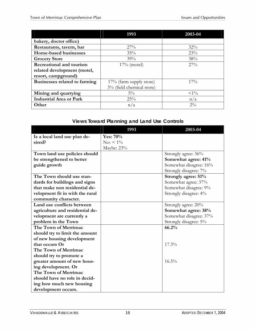
The following tables compare the results from the 2003-04 survey associated with Merrimac’s Comprehensive Plan to the survey conducted at the time the Town’s 1993 Development Plan was developed, focusing on comparisons based on General Information and Demographics, Views toward Preservation of Natural Resources, Desired Future Directions of Development, and Views toward Land Use Controls.
Figure 7: Comparison of 1993 to 2003-04 Survey Results General Information and Demographics
1993 2003-04
Primary or secondary residence
52.5% Primary 47.5% Secondary
58.6% Primary 41.4% Secondary
If secondary, intend to become year-round?
34.7% yes
How long have you been a property owner / lived in the Town?
0-2 years: 11% 2-4 years: 12% 4-8 years: 11% 8 + years: 65%
< 1 year: 9% 1-4 years: 21% 5-9 years: 14% 10-25 years: 32% 25+ years: 25%
Employed in: Sauk County: 24% Wisconsin (excluding Sauk): 20% Out of state: 29% Retired: 28%
Sauk County: 35% Dane County: 19.1% Columbia County: 1.4% Retired: 28.5% Other or not working: 15.9%
VANDEWALLE & ASSOCIATES 14 ADOPTED: DECEMBER 1, 2004

Town of Merrimac Comprehensive Plan Issues and Opportunities
Natural Resource Values 1993 2003-04
Importance of preservation of scenic character
Very important: 86% Somewhat important: 13% Not important: < 1%
Very important: 82% Somewhat important: 17% Not very important: 1% Not at all important: < 1%
Importance of preservation of agricultural lands
Very important: 66% Somewhat important: 30% Not important: 3%
Very important: 56% Somewhat important: 38% Not very important: 5% Not at all important: 1%
Importance of preservation of Baraboo Bluffs
Very important: 86% Somewhat important: 12% Not important: 2%
Very important: 80% Somewhat important: 18% Not very important: 1% Not at all important: < 1%
Importance of preservation of marsh/wetlands
Very important: 75% Somewhat important: 20% Not important: 5%
Very important: 67% Somewhat important: 24% Not very important: 7% Not at all important: 3%
Importance of water quality of Lake Wisconsin
Very important: 95% Somewhat important: 5% Not very important: 0% Not at all important: < 1%
Desired Future Directions for Development 1993 2003-04
Single-family, starter homes n/a 37% Single-family, mid-size homes n/a 74% Single-family, large homes n/a 41% Single-family, attached homes (townhouses or condominiums)
n/a 25%
Duplexes 24% 15% Apartments, 3-4 units per building
10% (apartments, general) 8%
Apartments, more than 4 units per building
10% (apartments, general) 4%
Mobile homes 3% (trailer court, park) 5% “Granny Flats” n/a 10% Senior/retirement housing 26% 34% Seasonal housing 23% Don’t want to see new housing
n/a 12%
Neighborhood shopping & offices (convenience store,
n/a 37%
VANDEWALLE & ASSOCIATES 15 ADOPTED: DECEMBER 1, 2004
Town of Merrimac Comprehensive Plan Issues and Opportunities
1993 2003-04
bakery, doctor office) Restaurants, tavern, bar 27% 32% Home-based businesses 35% 23% Grocery Store 39% 38% Recreational and tourism related development (motel, resort, campground)
17% (motel) 27%
Businesses related to farming 17% (farm supply store) 3% (field chemical store)
17%
Mining and quarrying 5% <1% Industrial Area or Park 25% n/a Other n/a 2%
Views Toward Planning and Land Use Controls 1993 2003-04
Is a local land use plan desired?
Yes: 70% No: < 1% Maybe: 23%
Town land use policies should Strongly agree: 36% be strengthened to better Somewhat agree: 41% guide growth Somewhat disagree: 16%
Strongly disagree: 7% The Town should use stan- Strongly agree: 51% dards for buildings and signs Somewhat agree: 37% that make non residential de- Somewhat disagree: 9% velopment fit in with the rural community character.
Strongly disagree: 4%
Land use conflicts between Strongly agree: 20% agriculture and residential de- Somewhat agree: 38% velopment are currently a Somewhat disagree: 37% problem in the Town Strongly disagree: 5% The Town of Merrimac should try to limit the amount of new housing development
66.2%
that occurs Or The Town of Merrimac should try to promote a
17.3%
greater amount of new housing development. Or The Town of Merrimac should have no role in deciding how much new housing development occurs.
16.5%
VANDEWALLE & ASSOCIATES 16 ADOPTED: DECEMBER 1, 2004

Town of Merrimac Comprehensive Plan Issues and Opportunities
Summary The above comparison suggests a great deal of consistency between the results of the current (2003-04) and past (1993) Town of Merrimac Public Opinion Surveys. The 1993 survey also suggested that residents were generally in favor of planning (70%). The consistency of results suggests an on-going interest in the scenic character, preservation of the Town’s agricultural character, the Baraboo Bluffs, and other features such as the Town’s marshes and wetlands. The compared results also suggest a continued interest in supporting small scale commercial and low-impact recreation as the preferred types of non-residential development in the Town. These key findings indicate that the 1993 Development Plan continues to reflect the views of the Town’s residents and landowners today. The new 2004 Comprehensive Plan will continue to forward the established land use objectives and practices set forth in the 1993 Plan.
2. Community Vision Forum In April 2004, the Town sponsored a Community Vision Forum. This Forum was an opportunity for Town residents to discuss their values about the Town, and the trends they feel are most critical in the future growth and development of the Town. The participants worked together to define key vision statements for the Town, and suggest potential objectives and strategies to attain those visions.
Over 25 residents and landowners participated in this event. There was a great deal of agreement on local values – notably the small-town / rural atmosphere, the outstanding recreational, environmental, and aesthetic benefits of the many natural and cultural resources of the Town, including the Baraboo Bluffs, Parfrey’s Glen, and Lake Wisconsin. Participants also valued the orderly growth of the Town achieved through the current development plan. They expressed that the size of the community was conducive to participating in local government decision-making and retaining a safe, quiet feel to the community. Among current trends affecting the Town, participants were concerned about threats to the rural, small town atmosphere from development and loss of agricultural lands.
The participants developed several key vision statements centering around the preservation of Land, Natural Resources, Rural Character and Natural Beauty, and Zoning and Planning for Appropriate Growth.
The Community Vision Forum was an opportunity for residents of the Town to get together to talk about their hopes and dreams for the future of Merrimac.
VANDEWALLE & ASSOCIATES 17 ADOPTED: DECEMBER 1, 2004

Town of Merrimac Comprehensive Plan Issues and Opportunities
H. KEY PLANNING ISSUES AND OPPORTUNITIES The Town of Merrimac is well positioned to achieve its visions over the next twenty years to maintain its rural, small town character. The Town has an excellent track record through its 1993 Development Plan of balancing limited growth and development while preserving the natural, agricultural, and cultural features of the Town that the residents place so much value on. The challenge over the next twenty years is to New home construction in the area between STH 78 and Lake Wisconsin continue to promote this abounds in the Town. One opportunity of this planning process is to determine balanced development and how and where new residential home development is desired by the Town. preservation in the face of increasing development pressure, transportation improvements facilitating increased “exurban” development, demographic shifts facilitating second home ownership, and increasing taxes.
In light of these issues and opportunities, the Town of Merrimac considered the following in this Plan:
� Development pressure from nearby communities and metropolitan areas � Pressure on the area’s natural resources from development, and increased tourism and
recreational activities (e.g. boating on Lake Wisconsin) � Expansion of existing developed areas affecting the community character � Increase in second and seasonal home ownership � Loss of agricultural base � Impacts of transportation system improvements � Affordability of housing/land � Escalating taxes and expenses
The following chapters of this Plan suggest strategies to address these issues, focused around the following set of opportunities.
� Focusing new residential development between STH 78 and Lake Wisconsin to preserve the rural lands of the Town north of STH7 78
� Exploring configurations of new development that maximize preservation opportunities with new development
� Enforcing existing and establishing new limitations on development to preserve the Town’s rural character and to promote improved water quality in Lake Wisconsin
� Allowing small home-based and rural businesses that promote the rural character of the Town
� Working with neighboring communities, the State, and the County to promote preservation or the Town’s resources
VANDEWALLE & ASSOCIATES 18 ADOPTED: DECEMBER 1, 2004

Town of Merrimac Comprehensive Plan Issues and Opportunities
I. OVERALL VISION AND OBJECTIVES Each chapter of this Comprehensive Plan includes a set of goals, objectives and policies which will provide the vision and policy guidance that the Plan Commission, Town Board, Town residents, and other interested groups and individuals need to guide the future preservation and development of the Town of Merrimac over the next 20+ years.
Visions, goals, objectives and policies are defined below:
� A Vision is a broad reflection of the Town’s desires for the future. This statement serves as the foundation for setting goals, objectives, and policies.
� Goals are broad statements that express general public priorities about how the Town should approach development issues during the next 20+ years. These goals are based on key issues, opportunities and problems that affect the community.
� Objectives are more specific than goals and are usually attainable through planning and implementation activities. The accomplishment of an objective contributes to the fulfillment of a goal.
� Policies are rules or courses of action used to ensure plan implementation and to accomplish the goals and objectives. The policies are intended to be used by decision-makers on a day to day basis.
The Town’s overall vision and goals to guide the future preservation and development in the Town of Merrimac over the 20-year planning period follow. This chapter does not discuss specific objectives, policies, and programs, which are instead included in subsequent chapters.
Town of Merrimac Overall Vision and Goals:
A. VISION STATEMENT The Town of Merrimac envisions that it will remain a rural community, defined by its beauty; small-town character; and rich natural, agricultural, and historical resources.
B. GOALS 1. Preserve the overall natural beauty and resources of the Town. 2. Retain agricultural land and preserve the viability of farm operations in the Town. 3. Maintain the predominantly single-family residential pattern of the Town. 4. Ensure that future land use development is consistent with the desired community
character of the Town.
VANDEWALLE & ASSOCIATES 19 ADOPTED: DECEMBER 1, 2004
Town of Merrimac Comprehensive Plan Agricultural, Natural, and Cultural Resources
VANDEWALLE & ASSOCIATES 20 ADOPTED: DECEMBER 1, 2004

Town of Merrimac Comprehensive Plan Agricultural, Natural, and Cultural Resources
Agricultural, Natural, and Cultural Resources
VANDEWALLE & ASSOCIATES 21 ADOPTED: DECEMBER 1, 2004

Town of Merrimac Comprehensive Plan Agricultural, Natural, and Cultural Resources
III. AGRICULTURAL, NATURAL AND CULTURALRESOURCES
Agricultural and natural resources are a defining feature of the Town of Merrimac, the preservation of which is a cornerstone of this Plan. This chapter contains a compilation of background data, goals, objectives, policies, and recommendations to guide agricultural preservation, natural resource conservation, and cultural resource protection in the Town of Merrimac area over the next 20 years, as required by §66.1001, Wisconsin Statutes.
A. AGRICULTURAL RESOURCES The Town of Merrimac is rich in agricultural resources and a heritage rooted in farming. In recent years, however, the Town has transitioned from a community where agriculture was a primary way of life, to a haven for residential and recreational home development. Still, farming activities and agricultural lands remain a central priority to the Town’s current residents, as well as its heritage. Land in agricultural uses comprises about half of the existing land area in the Town. The area is fortunate to possess well-drained, productive soils. The seasonal changes of growing crops, the colors and textures of farm fields, and the architecturally significant farm buildings all contribute to the rural appeal of the Town.
Glacial outwash helped form the areas fertile soils. Early settlement spurred a transition from predominantly prairie vegetation to a landscape dominated by agricultural cropland. Natural features such as flat to rolling farmland, the Driftless Area, the Baraboo Range, and the Wisconsin River bluffs create a varied “viewshed,” creating the Town’s appeal as a backdrop for residential development.
1. Character of Farming The primary agricultural product in the Town of Merrimac is corn. Despite the predominant rural character of the area, the relative importance of farming in the area has been declining as farmland is converted to other uses. According to the University of Wisconsin’s Program on Agricultural Technology, the total farmland acres on the assessment roll in the Town was approximately 5,751 acres or 37 percent of land in 1997. This was a decrease of 3.5 percent from 1990. For comparison, the entire County lost 5.3 percent of its farmland at an average of rate of 2,400 acres per year between 1990 and 1997. When compared to the other Towns in Sauk County, Merrimac was among those with the lowest percentage of their total land area taxed as farmland.
In terms of farm acreage, 1,018 acres of farmland were sold in Merrimac between 1990 and 1997. Of this total, 710 acres were converted out of agricultural uses, representing over 70 percent of the farmland sales during this time period. This represents a conversion of 12 percent of the Town’s total agricultural land area.
The actual number of farms in the Town actually increased between 1990 and 1997 from 39 to 42 farms. In contrast, countywide the number of farms decreased by 5.6 percent. During this same time period, the number of dairy farms declined from 11 to 4. This is a 63 percent reduction in dairy farms, over double the rate of dairy farm loss realized at the County level.
Community Survey Results
Nearly 86% of respondents agreed that Merrimac should promote the preservation of
farmland.
VANDEWALLE & ASSOCIATES 22 ADOPTED: DECEMBER 1, 2004

Town of Merrimac Comprehensive Plan Agricultural, Natural, and Cultural Resources
The State Farmland Preservation Program provides income tax credits to property owners who agree to keep their land in agricultural use. As part of this program, the State of Wisconsin provides Sauk County landowners with over $500,000 of tax relief credits annually. As shown in Figure 8, at the time this Plan was written, the Town of Merrimac had no landowner participation in the Farmland Preservation Program.
Figure 8: Farmland Preservation Tax Credit Participation by Town
Township % of Total Farmland Acres Claimed for Preservation
Town of Merrimac 0.0% Town of Honey Creek 71.5% Town of Prairie du Sac 91.5% Town of Sumpter 43.4% Town of Troy 96.9% Source: Sauk County
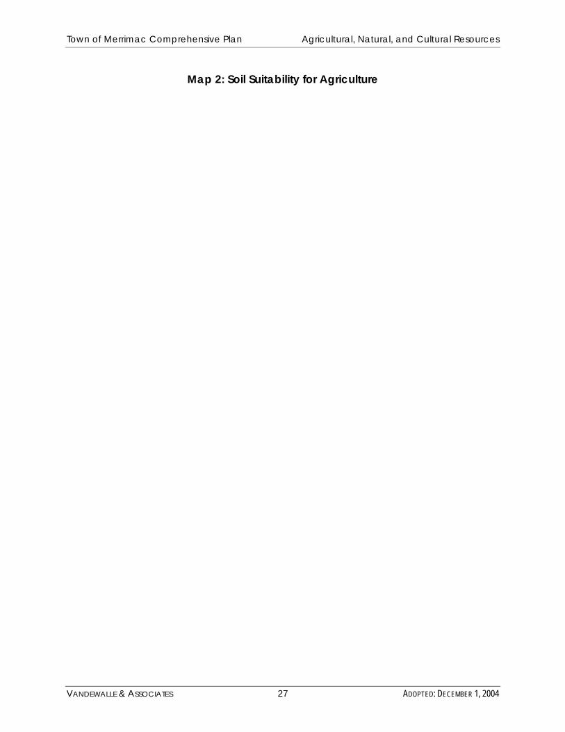
2. Assessment of Farmland Viability The suitability of land for farming is a critical aspect of its long-term viability for farming. The USDA Natural Resources Conservation Services group soils suitable for agriculture based on the most suitable land for producing food, feed, fiber, forage, and oilseed crops. Land capability classification identifies the relative degree of limitations for agriculture use inherent to the soils, their risk of damage, and response to treatment. In general, the fewer the limitations, the more suitable the soil is for agriculture, and the lower the costs of overcoming limitations. Group I soils have few limitations that restrict their use for agriculture; Groups II and III soils have moderate limitations that may reduce the choice of crops, require special conservation practices, or both. Groups IV through VIII are rated in descending order of suitability for agriculture. Most soils in the area that borders the Village of Merrimac are in Group II.
Map 2 shows soil suitability for the Town of Merrimac. There are no Group I soils in the Town. Group II and III soils are concentrated in the southwest and along the southern border adjacent to Lake Wisconsin, and along Highway 113. Other areas of Type II and III soils are scattered throughout the eastern portion of the Town. There are also large expanses of Type IV-VIII soils and gravel deposits.
B. AGRICULTURAL RESOURCE GOALS, OBJECTIVES AND POLICES
1. Goal: Preserve productive farmland for continued agricultural use and preservation of Merrimac’s rural character.
2. Objectives: a. Preserve productive farmland for continued agricultural use. b. Protect intensive farm operations from incompatible uses and activities. c. In productive farming areas, limit the amount of non-farm uses.
VANDEWALLE & ASSOCIATES 23 ADOPTED: DECEMBER 1, 2004

Town of Merrimac Comprehensive Plan Agricultural, Natural, and Cultural Resources
d. Work to preserve farming as a viable occupation, way of life, and open space preservation strategy.
e. Support appropriate opportunities for farmers to obtain non-farm income.
3. Policies and Programs: a. Designate most of the Town in the Planned Agricultural Preservation and
Conservation Areas (see Map 5) to minimize pressure to convert land to nonagricultural uses.
b. Limit/restrict the number of homes in the Agricultural Preservation and Conservation Areas, by following the Town’s zoning regulations. This is described in more detail in Chapter Four.
c. In cases where any type of new development is approved in designated Agricultural Preservation Areas, follow the guidelines below to ensure that it minimally impacts existing agricultural activities: � Guide the placement of homes, driveways, and other uses in the Agricultural
Preservation Area to less productive soils and the edges of agricultural fields, as described in more detail in Chapter Four.
� Promote the clustering of grouping of two or more homesites in the Agricultural Preservation Area consistent with the density policies, and promote the use of design guidelines to direct homes away from the best soils, to protect water quality, and to promote rural character.
� Promote the placement of dwelling units on small parcels of 1 ½ to 3 acres, in order to preserve as much land as possible in open land and agricultural uses.
d. Promote the continuation of the “family farm” by supporting agriculture-support businesses, and providing opportunities for small non-farm businesses to supplement farm income, including home occupations (bed and breakfasts, cottage industries, value-added agricultural production).
e. Support farmland tax credits, use value assessments, reform in federal farm laws, and other programs that encourage the continued use of land for farming.
f. Encourage participation in innovative programs that permanently protect large tracts of agricultural land while compensating the farmer for these protections, such as the Baraboo Range Preservation Program, the Farmland Protection Program, and conservation easements through the Baraboo Range Preservation Association, the Nature Conservancy, and other land trust organizations.
g. Promote the viability of the local farm economy and the growing of specialty-agricultural products by supporting and hosting parades, festivals, fairs, auctions, and other related events within the community; as well as supporting the local use of locally grown products through programs like Community Shares Agriculture.
C. NATURAL RESOURCE INVENTORY Preserving the Town’s natural resources is a priority of the Town and a major theme of this Plan. Understanding Merrimac’s natural features helps guide land use decision-making by delineating areas that are important to preserve, as well as those which offer possible locational advantages for particular land uses. Understanding the location of environmentally sensitive areas where development is not appropriate will prevent severe developmental or environmental problems that may be difficult or costly to correct in the future. Maintenance of these natural
VANDEWALLE & ASSOCIATES 24 ADOPTED: DECEMBER 1, 2004

Town of Merrimac Comprehensive Plan Agricultural, Natural, and Cultural Resources
The Baraboo Bluffs form a dramatic backdrop for the Town of Merrimac.
features is important for community appearance and the functions they perform for natural communities. Map 3 depicts the area’s natural features, some of which are described in detail below.
1. Landforms/Topography Situated on Lake Wisconsin and in the heart of the nationally recognized Baraboo Bluffs, a Natural National Landmark, the Town is a special place with outstanding natural beauty. A patchwork of wetlands, forests, and open spaces characterize the Town. The Town has a historically strong relationship to the Wisconsin River and Lake Wisconsin. Broad expanses of river surrounded by river-edge woodlands and rocky bluffs characterize the Wisconsin River Valley. This corridor contains a wide range of features including shifting sand bars, floodplain forests, back waters, rocky bluffs, migratory birds, sensitive ecosystems, endangered and threatened species, and eagle habitats.
Eastern Sauk County is located in the glaciated region of Wisconsin, where glacial activity approximately 12,000 years ago slowly eroded the hills and filled the valleys with glacial deposits. This activity created rolling, complex slopes.
The northern portion of the Town is located in the Baraboo Bluffs region, also called the Baraboo Range or the Baraboo Hills. These features are eroded remnants of an ancient red quartzite outcropping. The Bluffs extend 25 miles in an east-west direction across Sauk County and into western Columbia County.
2. General Soils Information In addition to helping assess farmland quality, soil suitability is a key factor in determining the best and most cost-effective locations for new development. Problems that limit development on certain soils including slumping, poor drainage, erosion, steep slopes and high water tables. Soil suitability is also a key factor in determining agricultural suitability, discussed later in the Agricultural Resources Inventory. Based on the Soil Survey for Sauk County (1980 - USDA Soil Conservation Service) soils in Merrimac can be grouped into four major types: Baraboo-rock outcrop, McHenry – St. Charles, Wyocena-Gotham-Plainfield, and Briggsville-Mosel-Colwood. These soils can be summarized within four primary geographical areas.
VANDEWALLE & ASSOCIATES 25 ADOPTED: DECEMBER 1, 2004

Town of Merrimac Comprehensive Plan Agricultural, Natural, and Cultural Resources
� The bluff areas covering about 12 square miles are found primarily north of Halweg Road and County DL. The predominant soils are sloping to very steep (6-60% slope). Baraboo stony silt loam and Baraboo-Rock outcrop complex are found primarily within the boundaries of Devil’s Lake State Park. The Baraboo soils in this area are poorly suited to septic tank absorption fields because of seasonal perched water table, the shallow depth to bedrock, and the slope. McHenry and St. Charles silt loams are the predominant soils outside the park boundaries in this area. Permeability is moderate in the McHenry and St. Charles soils. Given the slopes these two soils lay on, they are poorly suited to septic tank absorption fields. Other uses of these soils are quite limited.
� The area south of Halweg Road and west of Highway 78 is about four square miles in size. Most of this area is within the boundary of the Badger Army Ammunition Plant. McHenry and St. Charles silt loams are the primary soils found in this area. The gently sloping to moderately steep (2-20%) slopes of these soils distinguish them from those found in the bluffs. These soils are suited to septic absorption fields on slopes up to 6%.
� A circular area covering about two square miles is centered around the body of water northeast of the junction of Highways 113 and 78. The soils in this area include the Mosel and Colwood loams. These soils are poorly suited to septic systems because of the seasonal high water table, the moderately slow permeability, and the occasional flooding. These characteristics severely restrict many other uses as well.
� The remaining area of the Town is about six square miles of gently sloping (2-6%) soils in the Gotham, Plainfield loamy sands, and Wyocena sandy loam associations. These soils are highly permeable, and therefore suitable for septic systems. The rapid permeability may present a danger of groundwater contamination from septic systems.
The suitability of the various soils in Merrimac for on-site waste disposal (septic) systems is described in greater detail in Chapter 6—Utilities and Community Facilities.
3. Non-metallic Mineral Resources Under State Statutes (292.20), landowners who want to register their property as nonmetallic mining deposits are required to notify each county, city village and town that has zoning authority over their property. Registrations must be recorded at the County register of Deeds in the County where the mineral deposit is located. State law limits the ability of a municipality or a county to rezone or otherwise interfere with the future extraction of a mineral resource from a registered nonmetallic mineral deposit.
4. Drainage Basins Merrimac is located in the Lower Wisconsin River Basin, which drains approximately 4,940 square miles of south-central and southwestern Wisconsin. Basins are further divided watersheds, and the most of Merrimac falls within the Lake Wisconsin Watershed. The northeastern corner of the Town is located in the Lower Baraboo River Watershed.
VANDEWALLE & ASSOCIATES 26 ADOPTED: DECEMBER 1, 2004
Town of Merrimac Comprehensive Plan Agricultural, Natural, and Cultural Resources
Map 2: Soil Suitability for Agriculture
VANDEWALLE & ASSOCIATES 27 ADOPTED: DECEMBER 1, 2004

Town of Merrimac Comprehensive Plan Agricultural, Natural, and Cultural Resources
VANDEWALLE & ASSOCIATES 28 ADOPTED: DECEMBER 1, 2004

Town of Merrimac Comprehensive Plan Agricultural, Natural, and Cultural Resources
Community Survey Results
Nearly 95% of respondents stated it was “very important”
to preserve water quality in Lake Wisconsin.
Another 5% responded “somewhat important”
Within the Lake Wisconsin Watershed, development pressure, point and non-point source pollution, stream channelization, atrazine contamination, and nutrient loading are issues of concern. This watershed has been ranked as a medium priority in terms of non-point source pollution reduction. Several permitted point sources discharge into the watershed (including Chiquita Inc., Lodi Canning, and U.S. Badger Army Ammunition Plant). The Badger Army Ammunition Plant is a potential source of groundwater contaminants, including tricholorethylene, carbon tetrachloride and chloroform. There are also several sources of municipal discharge into the watershed, including Devil’s Head Lodge, Harmony Grove, and the Village of Merrimac, Lodi, and Poynette Wastewater Treatment Plants.
5. Surface Waters The Wisconsin River/Lake Wisconsin is the most prominent surface water feature in the Town, forming its southern boundary. The Wisconsin River and Lake Wisconsin is the foundation for the historic and current settlement patterns. Manley Creek, a tributary to the Wisconsin River, runs through the central portion of the Town. Parfrey’s Glen Creek is another significant resource in the Town. There are also several smaller lakes scattered throughout the area. These water resources are discussed in more detail below and are show on Map 3.
Within the Town, lands adjacent to surface water (within 1,000 feet of a lake, pond, or flowage and within 300 feet of other navigable waterways) are subject to County Shoreland Zoning regulation, which require building setbacks of 75 feet and the protection of vegetation within a 35 foot buffer area.
a. Wisconsin River/Lake Wisconsin The Wisconsin River/Lake Wisconsin forms the southern limit of the Town of Merrimac, separating Sauk County from Dane and Columbia Counties. In 1914, the River was dammed at in north of the Village of Prairie du Sac, creating the 9,000-acre Lake Wisconsin.
The Lake is generally thought to have a good sport fishery and it is widely used for recreation. In addition, the shoreline of the lake is a popular location for residential development. However, nutrient loading resulting in excessive algae growth and the potential for contaminated sediment have been identified as concerns in the Lake. In certain fish populations high levels of PCBs and mercury have been reported. Sediments containing high levels of mercury, lead and ammonia have also been reported. Dredging has occurred as a means to remove some of the contaminated sediment. Other aquatic habitat restoration activities, such as the planting of aquatic plants and shoreline trees have been proposed.
The Lower Wisconsin River below Merrimac and the Prairie du Sac dam, supports one of the healthiest large-river fish communities in the Midwest. Many parcels of land below Merrimac are designated as part of the Lower Wisconsin State Riverway. The Lower Wisconsin State Riverway was established to protect and preserve the scenic beauty and natural character of the lower Wisconsin River valley. The Lower
VANDEWALLE & ASSOCIATES 29 ADOPTED: DECEMBER 1, 2004

Town of Merrimac Comprehensive Plan Agricultural, Natural, and Cultural Resources
Parfrey's Glen Creek cascades down rock outcroppings in Parfrey's Glen Natural Area.
Wisconsin State Riverway Board administers aesthetic protection guidelines for the Riverway.
b. Manley Creek Manley Creek is a small tributary to the Wisconsin River originating in the bluffs that runs through the central part of the Town of Merrimac. According to the WisDNR, the stream is considerd a Class I trout stream, supporting some natural reproduction of brook trout. Much of this stream runs through the portion of the Town owned by Alliant Energy’s Riverland Conservancy. Cooperative efforts between the state, the Conservancy, and the Wisconsin Conservation Corp. have involved streambank restoration and have contributed to the maintenance of the stream’s water quality.
c. Parfrey’s Glen Creek Parfrey’s Glen Creek is a small stream that flows through a steep, rocky canyon in the northeastern part of the Town. This creek is classified by the WisDNR as an Outstanding Resource Water, supporting a Class I population of brook trout in the upper 1.1 miles of the stream. Some of the area surrounding the creek has been designated a State Natural Area.
6. Floodplains The Federal Emergency Management Agency (FEMA) designates floodplain areas. These general floodplain delineations represent the areas adjacent to navigable waters potentially subject to the 100-year flood event (1% change of occurring in any year). All areas of Merrimac subject to flooding are not necessarily reflected in mapped floodplains. The State requires County regulation of development in floodplains. Development is strongly discouraged in floodplains, to avoid both on-site and up- and downstream property damage.
As depicted on Map 3, floodplain areas in the Merrimac are primarily located along Manley Creek and portions of Lake Wisconsin.
7. Wetlands Wetland areas are important for aquifer recharge, flood control, groundwater and surface water quality improvement, and wildlife habitat, especially for nesting sandhill cranes and other birds. The Wisconsin DNR has identified and mapped wetlands of two or more acres in the Wisconsin Wetlands Inventory. Large wetlands areas line Manley Creek and its smaller tributaries. Other isolated wetlands are scattered throughout the Town. All wetland areas are depicted on Map 3.
VANDEWALLE & ASSOCIATES 30 ADOPTED: DECEMBER 1, 2004

Town of Merrimac Comprehensive Plan Agricultural, Natural, and Cultural Resources
Map 3: Natural and Cultural Areas
VANDEWALLE & ASSOCIATES 31 ADOPTED: DECEMBER 1, 2004

Town of Merrimac Comprehensive Plan Agricultural, Natural, and Cultural Resources
VANDEWALLE & ASSOCIATES 32 ADOPTED: DECEMBER 1, 2004

Town of Merrimac Comprehensive Plan Agricultural, Natural, and Cultural Resources
8. Groundwater Groundwater is found at various depths, depending on the general topography, the distance above the permanent stream level and the character of the underlying rock formation. Most groundwater in Sauk County and the Lower Wisconsin Riverway Basin is obtained from the Cambrian sandstone aquifer. Another important source of groundwater is the surficial sand and gravel deposits along the Wisconsin River. Groundwater is generally available at depths ranging from 5 to 500 feet. The groundwater in the basin is generally hard with a dissolved solid content of between 100 and 400 mg/l.
Groundwater in Merrimac is generally of good quality and is usable for most purposes. However, this area is often susceptible to human-induced and some natural pollutants. One potential threat to the water supply in the area is the groundwater contamination emanating from the Badger Army Ammunition Plant. The Army is working in collaboration with the WisDNR to sample residential wells for exceeding DNR drinking water standards for organic compounds. Preliminary sampling indicates no exceedances of these levels, but monitoring and precaution should continue. Monitoring for trace amounts of contaminants should continue.
Manure storage facilities also present a major potential risk to groundwater. There are likely many manure storage facilities in the watershed. Properly designed livestock waste storage facilities reduce the potential for causing groundwater pollution. Although regional evaluations are helpful in determining the target areas in the county, site-specific factors are most important in determining the threat of groundwater pollution from animal waste at the local level.
9. Woodlands The Town of Merrimac has several areas of significant woodland cover. These areas generally coincide with areas of steep slopes, as these areas are difficult to utilize for agriculture or home sites. The most common species found in the woodlands are oak, maple, and basswood.
As of February 2004, there were 229 acres of land in the Town enrolled in the WisDNR managed forest law program. This is comprised of 9 individual parcels of land. The MFL program was enacted in 1986. To qualify for MFL enrollment, the forest land must be at least 10 contiguous acres and participating landowners must adopt a forest management plan that includes harvesting at least 80 percent of their forested area. In exchange, their land is assessed for tax purposes at a rate below the state average. MFL landowners are not required to keep their land open for public recreational use.
Community Survey Results
Over 98% of respondents stated it is important to
preserve the woodland features of the Town of Merrimac.
The majority of the lands within the Baraboo Hills portion of the Town are heavily wooded. The Baraboo Hills are the largest area of contiguous hardwood forest north of the Ozark Mountains, and are a critical habitat for migrating birds and other wildlife.
10.Steep Slopes There are several large areas of steep slopes throughout the Town of Merrimac. In the northern portion of the Town in the area of the Baraboo Hills and river bluffs, slopes of
VANDEWALLE & ASSOCIATES 33 ADOPTED: DECEMBER 1, 2004
Town of Merrimac Comprehensive Plan Agricultural, Natural, and Cultural Resources
greater than 12 percent are common. Slopes greater than 12 and 20 percent in the Town are shown on Map 3.
Steep wooded slopes provide wildlife habitat, enhance scenic beauty, and generally provide a natural barrier to development. Slopes between 12 and 20 percent grade present challenges for building site development. Slopes that exceed a 20 percent grade are generally not recommended as development sites. Disturbing soils and vegetation on steep slopes can result in severe erosion and soil degradation, which can have an impact on nearby water resources, and cause damage to buildings, roads, and utilities.
11.Hilltops and Ridgetops Hilltop and ridgetop areas are important natural features that are often overlooked in the planning process. Hilltops and ridgetops located in the northern part of the Town of Merrimac serve to define the horizon. Large structures constructed on top of them tend to be visually prominent – especially if they do not blend in with the area’s character in terms of color, material, or style.
12.Rare Species Occurrences/Natural Areas The Wisconsin Department of Natural Resources Natural Heritage Inventory (NHI) program maintains data on the general location and status of rare, threatened, or endangered plant and animal species. This data is obtained through field inventories. According the NHI, as of 2001, there were 46 species or communities located in the Town of Merrimac. These include several rare plant communities as well as several rare individual plant and animal species. These areas generally coincide with water, roads, and wetlands. Effective protection of a natural community will also maintain populations of many native plants and animals, their interactions, and the ecological processes upon which they are dependent.
More specific information on location and type of species is available from the state’s Bureau of Endangered Resources.
13.Natural Areas Preservation
a. Devils Lake State Park Extending into the north and westernmost sections of the Town, Devil’s Lake State Park is a 9,117 acre State protected area featuring 500-foot quartzite bluffs, a 360 acre lake, and a wide range of other natural features. Devil’s Lake is the most commonly visited State Park in Wisconsin, popular during all four seasons. The park encompasses several recreational amenities including: nearly 30 miles of trails, 8 miles of off-road bike trails, boat launches, two swimming beaches, picnic areas, and three campgrounds. The Park contains hosts over 100 species of birds and 880 plant species. The lake contains brown trout, walleye, northern pike, bass, and other pan-fish.
b. Parfrey’s Glen State Natural Area Located in Devil’s Lake State Park and Wisconsin’s first State Natural Area, Parfey’s Glen is described as a “steep gorge deeply incised into the sandstone conglomerate of the south flank of the Baraboo Hills.” The area’s steep rock walls host species of flora more commonly found in northern Wisconsin, including state and federally threatened species. Two state-threatened birds are also found here. Parfrey’s Glen Creek flows
VANDEWALLE & ASSOCIATES 34 ADOPTED: DECEMBER 1, 2004
Town of Merrimac Comprehensive Plan Agricultural, Natural, and Cultural Resources
through the area, supporting a diverse insect fauna. The area is owned and administered by the DNR.
c. The Merrimac Preserve Wisconsin Power & Light purchased this more than 1,700 acre site in 1960. Initially, the property was purchased for a power plant site on the Wisconsin River. However, the Columbia Energy Center was later built further upstream, near Portage. The property remained undeveloped and under the power company’s ownership. The land was restored with native prairie, oak savanna, and wetland vegetation. In 1997, Alliant Energy created the Riverland Conservancy to provide permanent protection for this land.
The trust is supported through human and financial resources donated by Alliant Energy, and through numerous partnerships with local, state and national groups, with the goal of preserving ecosystems and providing a unique setting for environmental research and education.
The land trust is open to the public for non-impact use, such as bird watching and hiking. The Riverland Conservancy also arranges special events with environmental and educational organizations to teach people about conservation, share knowledge about the land's unique ecology or provide skills training for natural resource careers.
d. Baraboo Range Preservation Program Through a memorandum of agreement created with the expansion of USH 12, the Baraboo Range Preservation Program (BRPP) was enacted to preserve priority lands with the Baraboo Range National Natural Landmark Geographic Area. The BRPP purchases development rights from willing owners of forested or buffer lands adjacent to forested areas. At this time this plan was written, three properties in the Town of Merrimac were enrolled and several other were under consideration for enrollment.
e. Lower Wisconsin River State Riverway The intent of the Lower Wisconsin State Riverway is to minimize visual and environmental impacts on the Wisconsin River. The Lower Wisconsin State Riverway Board administers a system of regulations, known as “performance standards,” which are designed to protect and preserve the aesthetic integrity of all points visible from the river. The regulations are not designed to prohibit development, but rather, to control
The Merrimac Preserve is comprised of more than 1,000 acres of native prairie, wetland, and other natural ecotypes in the heart of Merrimac.
VANDEWALLE & ASSOCIATES 35 ADOPTED: DECEMBER 1, 2004

Town of Merrimac Comprehensive Plan Agricultural, Natural, and Cultural Resources
land use and development to assure consistency with the objectives of the Riverway program. The Riverway Board requires permits for construction of new buildings, modification of existing structures, placement of mobile homes, construction utility facilities, walkways or stairways that provide access to the river, and timber harvests.
f. Clingman Property Land Conservation Project In late 2003, the Town of Merrimac purchased 8.5 acres of undeveloped land to create a new conservation area off STH 78, adjacent to the Badger Army Ammunition Plant property. The property currently consists of 550 feet of Lake Wisconsin frontage and undeveloped forestland. This property provides important habitat to several wildlife species, including deer, turkey, eagles, and osprey. The area is intended to be used for both conservation and recreation purposes. Goals for the site include protecting existing riparian habitat, providing off-shore fishing opportunities, developing a hiking trail destination, and providing lake access. The WisDNR has acquired 2-3 additional acres adjacent to the Town property and additional acquisitions that will increase the total acreage of the conservation area.
g. Other Conservation Assistance Programs The Baraboo Range Preservation Association is a land trust organization focused on the preservation of the ecological and cultural qualities of the Baraboo Range through the purchase of conservation easements and encouraging enrollment in a land registry program. Other local conservation assistance programs include the Sauk County Preservation Program. The Nature Conservancy has been working to protect land in the Baraboo Bluffs area since the 1960s. As of early 2004, The Nature Conservancy had helped to protect over 9,218 acres in the Baraboo Hills. They own over 7,681 acres, including 11 preserves in the Baraboo Hills area. There are no properties or easements in Merrimac currently owned by TNC, but this remains another option available to Merrimac landowners.
D. NATURAL RESOURCE GOALS, OBJECTIVES AND POLICIES
1. Goal: Protect the Town of Merrimac’s outstanding and regionally significant natural features.
2. Objectives: a. Preserve and protect natural areas, including bluffs and steep slopes, woodlands,
shoreline, streams, drainageways, wetlands, floodplains, outcroppings, wildlife habitat, and scenic views.
b. Protect surface water quality and groundwater quality. c. Prevent future problems associated with developing land too close to natural areas and
on steep or erosion prone slopes. d. Cooperate with other units of government on the preservation of resources under shared
authority. e. Maintain the peace and tranquility of the rural setting by discouraging land uses that are
incompatible with the character of the community.
VANDEWALLE & ASSOCIATES 36 ADOPTED: DECEMBER 1, 2004

Town of Merrimac Comprehensive Plan Agricultural, Natural, and Cultural Resources
3. Policies and Programs: a. Preserve environmental and open space corridors by prohibiting new buildings in
wetlands, stream banks, floodplains, shoreland setback areas, and on slopes greater than 20%. The Town should consider an addendum to their existing zoning ordinance specifying “Natural Resource Protection Overlay Districts.” These could function to discourage development on slopes between 12 and 20%, wooded areas, and along drainageways.
b. Require detailed mapping of natural resources where it is apparent that a development proposal may impact these features, existing maps are in error, or changes have occurred in the features. Steep slopes, wetlands, and floodplains are shown on Map 3.
c. Preserve special landscape features including the Baraboo Bluffs, Lake Wisconsin and remaining undeveloped frontage, larger woodlands and wetland habitats.
d. Before approving any changes in land use, consider the impact on wildlife habitat, potential locations of rare plant and animal species, and archeological sites such as mound groups, and ensure that the land use changes meet all applicable criteria in the County’s land division and subdivision ordinances.
e. Protect and improve the quality of surface water within the Town, particularly Lake Wisconsin, Manley Creek, and Parfrey’s Glen Creek. Participate in any County or State water quality improvement efforts.
f. Provide and improve access to Lake Wisconsin and other natural areas in the Town. g. Emphasize use of natural drainage patterns, construction site erosion control,
and ongoing stormwater management measures that control the quality, quantity, and temperature of water leaving any site.
h. To protect groundwater quality, avoid the over-concentration of on-site waste disposal systems and seek alternatives that do not placed drinking water and surface water at risk.
i. Request the submittal and implementation of nutrient/or management plans for high density agricultural operations expected to have large numbers of animals in any part of the Town to prevent non point source runoff.
j. Avoid extensive development within designated groundwater recharge areas and steep slope areas to protect groundwater quality.
k. Encourage landowner participation in programs that provide financial and technical assistance for land management activities, for instance the Conservation Reserve Program, Conservation Reserve Enhancement Program, and Managed Forest Law
l. Encourage landowner participation in programs that assist them in land preservation efforts, including the Baraboo Range Preservation Program, the Nature Conservancy, and other conservation easements.
m. Cooperate with the WisDNR, Sauk County and other units of government on protection resources of shared concern, such as Devil’s Lake State Park and Lake Wisconsin.
n. Work with the National Park Service to site a portion of the Ice Age Trail through the Town of Merrimac.
VANDEWALLE & ASSOCIATES 37 ADOPTED: DECEMBER 1, 2004

Town of Merrimac Comprehensive Plan Agricultural, Natural, and Cultural Resources
E. DETAILED NATURAL RESOURCE RECOMMENDATIONS Expanding on the policies listed above, this section provides specific recommendations for conserving the Town’s natural areas.
1. Protect Environmental Corridors Environmental corridors are, in effect, a composite of important individual elements of the natural resource base. They have immeasurable environmental, ecological, passive recreational, stormwater management, groundwater protection and recharge, erosion control, wildlife, timber, and scenic value. Environmental corridors also have severe limitations for development; therefore, minimizing development in these areas also protects private property. Environmental corridors generally occur in a linear (corridor) pattern on the landscape (see Map 5 for Environmental Corridor delineations). Environmental corridors include the following areas:
� Wisconsin DNR-identified wetlands as mapped in the Wisconsin Wetlands Inventory and subject to existing zoning control. This layer may not include all wetlands that are subject to state and/or federal disturbance rules. Protection from development should be provided to these areas (also shown on Map 3) as well as those identified through more detailed field surveys to preserve the significant natural functions that wetlands provide.
� Federal Emergency Management Association (FEMA) designated floodplains subject to existing zoning control. These general floodplain delineations represent the areas potentially subject to the 100-year flood. All areas of the County subject to flooding are not necessarily reflected in mapped floodplains (or within the environmental corridor delineation). The Town should protect areas within the 100-year floodplain as shown on Flood Insurance Rate Maps and more detailed surveys from development to avoid damage to property and the health, safety and welfare of the community.
� Lands with steep slopes of 20 percent or greater. Due to the instability of these soils and erosion concerns, development (including buildings and driveways) on these steep slopes is not advisable. There are several small areas of steep slopes in the Town (shown on Map 3), although none of these areas are recommended for development. Slopes of 12%-20% should be subject to detailed development plans with site-specific designs to minimize disruption and maximize slope stabilization.
New development should generally be discouraged in environmental corridors, and is often very limited by existing zoning. Development types should be limited to those which will not impair the resource, and which are compatible to existing and proposed uses on surrounding lands. New homes and other buildings should not be placed in these areas if other, more appropriate, building sites are available outside the environmental corridor. Sensitivity to surrounding natural resources should be the guiding principal when reviewing the appropriateness of development in mapped environmental corridors. The Town should encourage developers to minimize the “footprint” of any residential or non-residential project in corridor areas.
One possible way to achieve additional protection for natural resources is through Town adoption of Natural Resource Protection Zoning Overlay Districts that define the resources (woodlands, steep slopes, drainageways, etc.) and sets specific standards and conditions for development in those areas.
VANDEWALLE & ASSOCIATES 38 ADOPTED: DECEMBER 1, 2004

Town of Merrimac Comprehensive Plan Agricultural, Natural, and Cultural Resources
The environmental corridors depicted in Map 5 are necessarily general and should be used to identify general areas where development may not be appropriate. Lands within that designation may be removed under one or more of the following circumstances:
� More detailed study reveals that the characteristic(s) which originally resulted in its designation as an environmental corridor no longer exists, never existed, or exists in a different location or configuration on the site.
� Approvals from appropriate agencies are granted to alter a property so that the characteristic which resulted in its classification as an environmental corridor will no longer exist, or
� A mapping error has been identified.
The Town’s Planned Land Use Map (Map 5) shows the relationship between environmental corridors and other existing and proposed land uses. Chapter Five, Land Use, includes specific policies and programs for lands in environmental corridors.
2. Protect Surface Water Quality The Town’s surface water resources, in particular Lake Wisconsin and the high quality streams running through the Town, are valued local resources that the Town identified as priorities in this planning process. Protecting the water quality of the lake and rivers is an objective that extends beyond the boundaries of the Town. The Town may wish to cooperate with the WisDNR, Sauk County and neighboring communities to develop and implement strategies to maintain the water quality.
Several efforts at the State level that impact water quality planning and regulation have been undertaken in recent years. In 2002, WisDNR and DATCP established administrative rules to address nonpoint pollution sources (i.e. where contaminants do not come from a pipe or other easily identifiable sources). Much of the work for implementing the rules will be carried out by county land and water conservation staff.
This Town Comprehensive Plan does not seek to cover all of these efforts in depth. Instead, general recommendations designed to support the objectives of protecting the quality of the Town’s water resources are offered below.
a. River/Lake Management Programs The Wisconsin River / Lake Wisconsin system is a prominent landscape feature in Merrimac. To promote the long-term protection of this resource, the Town could organize and sponsor a river or stream clean-up program for local residents who want to learn more about and improve the quality of the Town’s water resources. The Town could utilize the support, information materials, “how-to” packets, press releases, and potential sponsor lists from Wisconsin’s Water Action Volunteers---a program coordinated through a partnership between WisDNR and UW Extension. The Town could seek out citizens, civic groups, 4-H clubs, and other volunteer groups to participate in the clean-up program. The effort could be held in conjunction with the National River Cleanup Week, which is traditionally held during the second or third week in May.
VANDEWALLE & ASSOCIATES 39 ADOPTED: DECEMBER 1, 2004
Town of Merrimac Comprehensive Plan Agricultural, Natural, and Cultural Resources
b. Vegetative Buffers Vegetated buffers provide many benefits, including the protection of water quality, flood control, stream bank stabilization, water temperature control for the Town’s lakes and streams, and room for lateral movement of stream channels. Trees and shrubs retained in buffer areas provide the benefit of buffering noise from watercraft, providing privacy to residents, and serving as nesting areas for songbirds. The Sauk County Shoreland Zoning ordinance regulates the removal of vegetation in an area extending from the ordinary high water mark to 35 feet inland. In addition, with zoning permit application, a restoration plan that restores the water quality, natural habitat, and aesthetic functions of the buffer area should be prepared and implemented.
The following additional buffering techniques can maximize water quality protection, habitat, and erosion control benefits in buffer areas around lakes and rivers in the town:
� Landscaping with native sedges and grasses, broadleaf groundcover plants, shrubs, subcanopy, and canopy trees, instead of mowed lawns. A complete buffer contains a canopy tree layer, a mid-canopy layer (smaller or younger trees such as ironwoods, hazels, or willows), and a ground layer of shrubs, ferns, forbs, and native grasses.
� Encouraging wider buffer areas. Although the County standard of 35 feet is a good minimum, wider buffer areas (e.g., 70 feet) generally increase water quality, wildlife habitat, and erosion control. The Town should encourage developers and landowners to consider wider buffers.
� Minimizing use of pesticides and fertilizers in the buffer area. These chemicals can leach into the lake, compromising the water quality and killing insects that are important food for the fish, birds, and other wildlife.
Figure 9: Benefits of Vegetative Buffers
Source: Vandewalle & Associates 2004
VANDEWALLE & ASSOCIATES 40 ADOPTED: DECEMBER 1, 2004
• Aesthetics• Noise filter• Wildlife viewing• Privacy• Easy to maintain• Low cost
Social Benefits
Wildlife Habitat• Shade, shelter, food• Movement corridors
~ • Fishery improvement
Llc"~ce'k.8jBuffer Area
• Bank and soil stabilizati~• Pollutant filtr,'~t;<on<L--'~;::=-->• Nutrient retention and utilization• Thermal stabilization• Stormwater runoff control• Erosion control
-~Water Quality

Town of Merrimac Comprehensive Plan Agricultural, Natural, and Cultural Resources
c. Erosion Control and Stormwater Management Plans Unmanaged construction sites are one of the greatest contributors to off-site sediment runoff. Currently, under a recent change to State law, erosion control plans are required for all construction sites over 1 acre in area. The Town should require proactive erosion control and stormwater management techniques to ensure protection of its outstanding water quality. In particular, stormwater management and erosion control systems should be planned components of planned new development areas, including subdivisions and commercial projects. Erosion control techniques include silt fencing, minimizing disturbed areas, and quickly reestablishing vegetation. Stormwater management techniques include natural drainage swales and retention and detention basins. These techniques control the quantity and improve the quality of water run-off during storms and enhance groundwater recharge, which is particularly critical near sensitive waters such as the Lake Wisconsin.
d. Lake and River Improvement Funding Several sources of partial funding for river and lake management projects are available through the WisDNR. These include:
� Community Conservation Aids, allocated to projects related to provide improved fish or wildlife habitat.
� Lake Management Planning Grants, available to gather information needed to protect and restore lakes and watersheds.
� Lake Protection Grants, available to improve quality of lakes and their ecosystems through purchase of land or easements, wetland restoration, development of local regulations to protect water quality, and other lake improvement activities.
� Local Water Quality Management Planning Aids, to assist in development and implementation of area wide water quality management planning activities.
More specific information on the availability of funds, matching, eligibility, and award procedure is available through the WisDNR.
3. Protect Groundwater Quality and Quantity Groundwater is the source for nearly all of the Town’s drinking water supply. If groundwater is removed from an aquifer more quickly than it is recharged, the amount of water available in the aquifer is reduced. This may be of particular concern where water tables are dropping rapidly resulting from growth-induced groundwater use in portions of the Town with high concentrations of dwelling units. For these reasons, groundwater protection is critical. This Plan supports several efforts to protect groundwater quality and quantity, including the following:
� Avoid planning for new development within 1,200 feet of closed landfills in the Town. To protect drinking water quality and public health and safety, the WisDNR requires a separation of 1,200 feet (a little less than ¼ mile) between open or closed landfills and nearby private water supply wells. This separation is measured from the edge of the nearest exaction area or, if unknown because it’s a filled site, from the site’s property line. In order to drill a well in this 1,200 foot area, a variance must be obtained from the WisDNR. There are several closed landfill sites in Merrimac. They are shown on Maps 4 and 5. In considering variances for wells in these buffer areas, the WisDNR considers water flow direction, existing contamination through sampling, and the how
VANDEWALLE & ASSOCIATES 41 ADOPTED: DECEMBER 1, 2004
Town of Merrimac Comprehensive Plan Agricultural, Natural, and Cultural Resources
individual landfills have been used, as well as any proposed potential protection measures for the well. Existing residential development shown in the private well setback area may pre-date WisDNR regulations, or may have been granted a variance due to site-specific factors. Additional development and siting of wells in this area is discouraged.
� Remain informed and involved in decisions pertaining to high-capacity wells. Permits for high capacity wells (those withdrawing more than 100,000 gallons per day) must be registered with and permitted by WisDNR. The DNR will not approve wells that impair public water utility supplies. Wells drawing more than 2 million gallons per day are evaluated in terms of whether they impair public water rights, future water use plans, or cause adverse groundwater effects. Should potential new sites be proposed in Merrimac over the planning period, the Town should remain informed and involved in any WisDNR decisions regarding high-capacity well decisions. One way to stay involved in through regular communication and providing public comment during Environmental Impact Statement review periods. The Town could also consider participating in cooperative groundwater management plans with municipalities, industries, local and regional planning agencies, and state agencies where appropriate, should special groundwater protection priority areas be delineated in the future.
4. Support Woodland Management Efforts The Town’s woodlands are a critical component of the area’s recreational base and rural economy. These woodlands provide timber revenues to private landowners and abundant recreational opportunities for both residents and visitors. Development located near and within the Town’s vast woodlands should be planned and sited to minimize adverse effects on the resource.
This Plan sets out specific conditions and processes a landowner must demonstrate adherence to prior to removal of greater than 10% of the forested cover of his/her property. Before any logging activities commence in Merrimac, the private landowner or contractor prepare a forest management plan. This plan, covering activities from road construction, timber harvesting and site preparation, should use WisDNR’s Best Management Practices (or BMPs). BMPs help to ensure the long term maintenance of local woodlands and other natural resources, while promoting their economic utilization. These forestry BMPs are intended to reduce the amount of erosion related to logging activities. A contractor, such as the logger or road developer, is usually responsible for implementing forestry BMPs. The regional DNR forester can work with private landowners to develop the forest management plan. WisDNR has cost-sharing assistance for plans written by a consulting forester.
The Town will require a forest management plan prepared by a certified forester for any selective harvest of greater than 10%. Harvest of greater than 30% would require a conditional use permit. The Town will consider exceptions to this rule for forest management practices that involve removal of invasive and/or exotic species and other woodland maintenance practices. These generally would fall under the 10% rule.
As another method to preserve this important natural resource over the planning period, the Town should encourage private landowners to participate in the State’s Managed Forest Land (MFL) Program. Adhering to a forest management plan—prepared for each piece of MFL-enrolled property—is a requirement of the program.
VANDEWALLE & ASSOCIATES 42 ADOPTED: DECEMBER 1, 2004

Town of Merrimac Comprehensive Plan Agricultural, Natural, and Cultural Resources
The WisDNR administers funding to encourage stewardship and sound management of privately owned forested lands. These include:
� Forest Stewardship Grants, available to assist landowners with active management of their forest and related resources. Awards typically support technical assistance, informational and educational materials.
� Forest Stewardship Incentives, provided to implement practices that protect, maintain, and enhance forest resources including wetlands, lakes and streams through Forest Stewardship Plans, tree planting and stand improvement, soil and water protection, and other habitat enhancements.
5. Protect Rare Species and Wildlife Habitat Areas Preservation of wildlife habitat and rare plant and animal species has many benefits. It enhances the quality of residents’ lives, preserves rural character, increases pride and stewardship in private land ownership, and enhances recreation and tourism. Preserving habitat and protecting rare species at the local level may also minimize the potential that a species will officially become “threatened” or “endangered,” thereby requiring federal intervention under the Endangered Species Act.
The WisDNR—Bureau of Endangered Resources maintains a database entitled the Wisconsin Natural Heritage Inventory (NHI). Map 3 shows all sections in the Town where rare plant or animal species and natural communities have been documented in that database. Because rare species are vulnerable to collection and intentional destruction, the exact locations and type of rare species is not made readily accessible. However, this data is available through submittal of a “Wisconsin Natural Heritage Inventory Request Form” which the Town should submit or require whenever a new subdivision or major development proposal is offered within a section of land where a rare species has been identified. Rare species have been identified in the areas throughout the Town. As discussed previously, vegetative buffers may be an effective way to retain habitat while these areas experience development pressure, or to restore habitat where development has already occurred.
Many of the WisDNR administered funding sources discussed in the water quality and woodland management sections above also include funding for habitat improvements.
6. Carefully Review Proposals for Mineral Extraction Sites While there are currently no mineral extraction (e.g., quarry) operations in Merrimac, over the planning period the Town should be aware of and carefully review any proposal for such land use activity. Mineral resources have potentially significant economic, community, and environmental impacts. Mineral resources are placed in two general categories—nonmetallic (e.g., sand and gravel) and metallic (e.g., gold, silver, copper). Wisconsin now has administrative rules on the reclamation of nonmetallic mines (NR 135). The rules require virtually all nonmetallic mines operating on or after September 1, 2001 to obtain a nonmetallic mine operation and reclamation permit. The new State standards address the reclamation of mineral extraction sites after extraction operations are complete. The Town should work with the County to assure that applications for approval of extraction operations present a clear picture of proposed activities, suggested by Vandewalle & Associates, through submittal of the information listed below before approvals are issued.
VANDEWALLE & ASSOCIATES 43 ADOPTED: DECEMBER 1, 2004

Town of Merrimac Comprehensive Plan Agricultural, Natural, and Cultural Resources
The applicant should submit a written statement containing the following information:
� General description of the operation. � The types and quantities of the materials that would be extracted. � Proposed dates to begin extraction, end extraction, and complete reclamation. � Geologic composition and depth to the mineral deposit. � Existing use of the land. � Existing natural and archeological features on and adjacent to the land. � Where extracted materials would be hauled and over what roads. � Types, quantities, and frequency of use of equipment to extract, process, and haul. � Whether blasting, drilling, crushing, screening, or washing would be performed on site. � Any proposed temporary or permanent structures (e.g., scales, offices). � Proposed hours of operation. � Proposed use after reclamation. � Any special measures that will be used for spill and dust prevention and control.
The applicant should also submit a site/operations plan map showing the following information:
� Boundaries of the extraction site. � Existing contour lines. � Existing roads, driveways, and utilities. � Existing natural features, including lakes, streams, floodplains, and wetlands. � Proposed erosion control and stormwater management strategies and areas. � All residences within 1,000 feet of the extraction site. � Location of the proposed extraction operation, staging areas, and equipment storage
areas. � Proposed location and surfacing of roads, driveways, and site access points. � Proposed phasing plan, if any (recommended for larger sites). � Proposed fencing of property and gating of driveways, and type of screening berms and
landscaping. � Proposed locations of stockpiles. � Proposed temporary and permanent structures, including scales and offices. � An erosion control plan prepared by a qualified engineer. � A biological inventory detailing the flora and fauna present, with particular attention to
threatened, endangered, and sensitive species.
In its review of proposals for mineral extraction, the Town should consider the following issues:
� The site will be developed and operated according to the site/operations plan. � Implications for air quality, noise pollution, and traffic generation. � Spraying of the site and driveways should be considered to control dust. � On-site bulk fuel storage and appropriate places for fueling of equipment (e.g., above the
water table) should be addressed to minimize the potential for groundwater contamination.
� Access should only be through services points designated as entrances on the site/operations plan.
VANDEWALLE & ASSOCIATES 44 ADOPTED: DECEMBER 1, 2004

Town of Merrimac Comprehensive Plan Agricultural, Natural, and Cultural Resources
� Hours of operation may be limited if the extraction site is close to residential properties. � Expectations for any blasting, drilling, screening and hours should be clearly understood. � If blasting or drilling is requested, additional standards may be applied with relation to
frequency, noise and vibration levels, notice to neighbors, pre-inspection of neighboring basements and wells, and claims procedures.
� Unless the extraction site is very inaccessible, it should be completely enclosed by a safety fence or maintained at a gentle slope.
� The petitioner should have to furnish a certificate of insurance before operations commence. The Town should be listed as an “additional named insured” on the liability insurance policy.
� Provisions for the upgrade, repair, and maintenance of Town roads may be appropriate. Posting a bond for such work may be required.
7. Build on the Town’s Natural and Cultural Resources to Promote Tourism The possibility for expanding Merrimac’s role in a nature-based tourism economy provides the opportunity for area residents to enjoy financial benefits of increased economic development while simultaneously preserving the area’s environment.
The area’s abundant natural areas are particularly well-suited to attract growth in nature-based activities, including hiking, fishing, paddling, and wildlife watching. Devil’s Lake State Park and Parfrey’s Glen State Natural Area are among the most visited and celebration natural areas in the State. The Wisconsin River / Lake Wisconsin is a popular venue for boating and fishing. The Ice Age Trail is a regional attraction that will bring walkers and bikers through the Town of Merrimac. This Plan recommends a connection from the Merrimac Preserve through the Town, to the Village of Merrimac, to the ferry.
Merrimac should promote opportunities for tourist and locals alike to explore and enjoy natural resources, and encourage businesses and community design that cater to these types of activities, in partnership with the neighboring Village and the County. There are many type of businesses that respond to the market of tourists attracted to the area for its outdoor recreation opportunities, including restaurants, nature stores (e.g. bird and wildlife related items, gift shops, and art galleries), and a sporting goods store that if limited to very small-scale, design compatible uses, would complement the rural character of the Town. Small-scale lodging facilities such as a bed and breakfast establishment, a small in (4-6 rooms), or rental cabins may also be appropriate uses in the Town.
F. CULTURAL RESOURCE INVENTORY Preservation of historic and cultural resources fosters a sense of pride, improves quality of life, and provides an important social and cultural continuity between the past, present and future. The following sections describe the significant historic and archeological resources in the Study Area. Known archeological and historical sites, identified by local, state, and national sources are included on Map 3.
1. Historic Resources The Town of Merrimac has a rich sense of history evident in both its natural and built landscape. The Merrimac Ferry was instrumental in creating recognition for the Town in the late 1800’s. The original ferry was built in 1844, when Chester Mattson was granted a
VANDEWALLE & ASSOCIATES 45 ADOPTED: DECEMBER 1, 2004

Town of Merrimac Comprehensive Plan Agricultural, Natural, and Cultural Resources
charter to build a state road connecting Madison to Baraboo and requiring a crossing of the Wisconsin River. The original ferry was hand-powered. In progression, the ferry’s operation has utilized overhead cables and a gasoline engine with underwater cables. The current ferry was built in 2003. The ferry is listed on the National Register of Historic Places.
As of February 2004, there were three properties in Merrimac listed on Wisconsin’s Architecture and Historic Inventory. The designated historic places include two Chicago and Northwestern Railway bridges- one a deck truss structure and the other a stone arch bridge, and the CCC Camp on South Lake Road. These locations are also identified on Map 3.
Located off 113, Merrimac’s historic Chapel School was built in 1927. The school was restored in 1997, and this local historic landmark now serves as the Town Hall.
The National Natural Landmarks Program recognizes and encourages the conservation of outstanding examples of the nation’s natural history. It is the only natural areas program of national scope that identifies and recognizes the best examples of biological and geological features in both public and private ownership. To date, fewer than 600 sites have been designated, 18 of which are located in Wisconsin. In 1980, the Secretary of the Interior designated a 50,700-acre area encompassing the "South Range" of the Baraboo Hills in Sauk County as the Baraboo Range National Natural Landmark (BRNNL) because of its outstanding geology and diverse ecological resources. The landmark is an excellent example of an exhumed mountain range. The formation of Devil's Lake within the pre-glacial Wisconsin River valley is an outstanding example of glacial drainage modification.
2. Archaeological Resources The Town does contain many sensitive archeological sites. As of February 2004, the State Historical Society and local sources recorded 58 known archaeological sites and cemeteries in the Town of Merrimac (see Map 3). This list, however, does not include all of the sites that might be present in Merrimac, as only a small portion of the Town has been surveyed. In addition, the locations shown on the Map 3 are necessarily general (by section only) to ensure protection of these sites. Sites that have been identified include 27 cemeteries (burial mounds and unmarked graves), Native American community sites and burial grounds, military sites, farms and businesses. There are a large number of effigy mounds located in the Badger Army Ammunition Plant area, and there are likely more sites in that area. Under Wisconsin Law, Native American burial bounds, unmarked burials, and all marked and unmarked cemeteries are protected from encroachment by any type of development. Many of these sites are located on private land and may not be viewed by the general public.
G. CULTURAL RESOURCE GOALS, OBJECTIVES AND POLICIES
1. Goal: Preserve Merrimac’s rich rural, scenic, and historic character.
2. Objectives: a. Identify and protect unique historic and archeological areas within the Town. b. Protect scenic views, particularly of rolling countryside, along Lake Wisconsin, and the
Bluffs.
VANDEWALLE & ASSOCIATES 46 ADOPTED: DECEMBER 1, 2004

Town of Merrimac Comprehensive Plan Agricultural, Natural, and Cultural Resources
c. Recognize Merrimac’s character is defined by large areas of rolling agricultural lands, dramatic bluffs, woodlands and natural areas, and historic areas.
3. Policies and Programs: a. Emphasize the value of natural resource areas as focal points of natural beauty and
recreation. b. Promote the nomination of historic sites to the National or State Registers of
Historic Places. Ensure that new development in these areas respected that historic integrity and small scale of these districts.
c. Consider the completion of the Ice Age Trail through the Town as a way to showcase the area’s natural and cultural history.
d. Encourage new development forms that celebrate the Town’s agricultural heritage and rich history. Examples include grouping new residences together at the end of a driveway or road to look like a historic farmstead, incorporating existing farm outbuildings in a new development project, or promoting new building styles and materials consistent with historic styles.
e. In largely undeveloped areas, promote the use of existing topography and vegetation to screen new development from public roads.
f. Support local festivals, fairs, farm tours, farm breakfasts, and markets that celebrate the Town’s farming heritage and rural way of life.
g. For the STH 78 corridor, implement a setback with required landscaping for new development that preserves the rural character throughout the Town. This community design recommendation is explained in more detail in Chapter Four, Land Use.
VANDEWALLE & ASSOCIATES 47 ADOPTED: DECEMBER 1, 2004

Town of Merrimac Comprehensive Plan Agricultural, Natural, and Cultural Resources
VANDEWALLE & ASSOCIATES 48 ADOPTED: DECEMBER 1, 2004

Town of Merrimac Comprehensive Plan Chapter Six: Utilities and Community Facilities
Land Use
VANDEWALLE & ASSOCIATES 49 ADOPTED: DECEMBER 1, 2004

Town of Merrimac Comprehensive Plan Chapter Six: Utilities and Community Facilities
IV. LAND USE This chapter contains a compilation of background information, goals, objectives, policies and recommended programs to guide the future preservation and development of public and private lands in the Town of Merrimac. The chapter includes maps that show existing land uses and recommended future land uses, and provides other related land use data and analysis as required under §66.1001, Wisconsin Statutes.
A. EXISTING LAND USE CATEGORIES An accurate depiction of a community’s existing land use pattern is the first step in planning for a desired future land use pattern. The project consultants conducted an inventory of the Town’s existing land using data from Sauk County, aerial photography, a field analysis, and consultation with town representatives.
1. Rural/Environmental Land Use Designations a. Agriculture or Undeveloped: land in cropland, farmsteads, pasture, open space, and
agricultural support buildings and activities, with farm family businesses, and limited residential development at or below a density of 1 dwelling unit per 35 acres.
b. Preserved Public Open Spaces: publicly-owned land designated as state parks, scenic areas, or conservation areas; county parks or recreation areas; town or village parks; or other recreational facilities owned by the public (Town, County, State).
c. Preserved Private Open Spaces: privately-owned land designated natural, scenic areas, conservation areas, or other recreational facilities
d. Woodlands > 40 acres: privately-owned forest land, in certain cases including private recreational uses or single-family residential development generally at densities at or below 1 dwelling unit per 35 acres.
e. Surface Water: lakes, rivers and perennial streams.
2. Residential Land Use Designations a. Rural Residential: single-family residential development, generally at densities between
1 dwelling unit per 5 acres and 1 dwelling unit per 35 acres, although some smaller lots (down to as small as 1 acre) do occur. Lots are typically created by certified survey map and served by on-site waste disposal systems.
b. Rural Subdivision: residential developments that have been platted. These developments tend to have densities varying between 1 home per acre and 1 home per 5 acres. Development within these areas are typically served with private wells and septic systems that may serve homes as individual or group/community systems.
c. Village Residential: single-family detached residential development served by a public sanitary sewer system within the Village of Merrimac.
3. Non-residential Designations a. Recreation Commercial: resort development and traveler supported retail or service
uses. b. Commercial: indoor commercial, office, institutional, telecommunications, and outdoor
display land uses, with low to moderate attention to building design, landscaping, and signs.
VANDEWALLE & ASSOCIATES 50 ADOPTED: DECEMBER 1, 2004

Town of Merrimac Comprehensive Plan Chapter Six: Utilities and Community Facilities
c. Institutional: large-scale public buildings, hospitals, airports/landing strips, non-profit campgrounds, and special care facilities. Small institutional uses may also be shown in this category of may be found in areas designated in other land use categories.
d. Industrial: indoor industrial land uses and occasionally outdoor storage areas, generally with modest landscaping and signage.
B. EXISTING LAND USE PATTERN The environmental features of the Town of Merrimac play a critical role in shaping the area’s land use patterns. Most of the Town’s Residential development is concentrated on the Wisconsin River/Lake Wisconsin. In addition, there are residential parcels scattered throughout the Town. Much of the Town is comprised of Preserved Public Open Space, including Devil’s Lake State Park and the Merrimac Preserve in the central area. Devil’s Head Resort, classified as Recreation Commercial, is a prominent feature in the northeast section of the Town. Commercial uses are situated along major roadways, including STH 78, 113, and CTH DL. Agriculture is the primary land use in the southeast and southwest parts of the Town. The decommissioned Badger Army Ammunition Plant extends into the western portion of the Town, classified as an Institutional use. Figure 10 shows the amount, type, and intensity (or percentage) of each land use in the Town of Merrimac as of 2004.
Figure 10: Existing Land Use Totals – Town of Merrimac, 2004
Land Use Acres Percent
Agricultural or Undeveloped 6,867 42 Preserved Public Open Space 3,433 21 Preserved Private Open Space 1,800 11 Rural Residential 593 4 Rural Subdivision 748 5 Commercial 26 < 1 Recreation Commercial 475 3 Institutional 2,276 14 Industrial 3 < 1 Highway Right of Way 186 1 TOTAL 16,407 100 Source: GIS Inventory, Sauk County, 2003
1. Land Development Trends Between 1994 and 2003, the Town issued 612 building permits, averaging about 77 permits annually – including remodeling, accessory permits, and new construction. Over 70 percent of the total value of these permits was for new residences.
Community Survey Results
Over 80% of respondents agreed that “most new development
should occur adjacent to areas that are already developed.”
VANDEWALLE & ASSOCIATES 51 ADOPTED: DECEMBER 1, 2004

Town of Merrimac Comprehensive Plan Chapter Six: Utilities and Community Facilities
Over the past decade the Town has had significant development activities. Between 1994 and 2004, there were 25 new lots created by certified survey map.
In addition, the Town approved the Water’s Edge subdivision, consisting of 43 lots, in 2000. This subdivision was created on an area of land formerly used as the Boat Club. As of early 2004, about 14 building permits had been issued. In early 2003, the Town approved Lakeview Estates on a parcel of land formerly used as a mobile home complex. This subdivision includes 66 lots of predominantly single family residential development. Up to 12 two-family units may be constructed. About 1/3 of the lots created are waterfront lots. All lots range in size from .39 to .99 acre. As of early 2004, 9 building permits had been issued. Both Waters Edge and Lakeview Estates are Planned Area Developments (PADs).
Foster Shores and Eagle Point subdivisions were developed prior to 1993, but more significantly built-out in years to follow. At the time this Plan was written, Eagle Point was nearly completely full; however there is a lot of off-shore acreage that remains available in Foster’s Shores.
2. Land Market Trends The State Department of Revenue (DOR) reported an increase in the total equalized value from 2002 ($140 million) to 2003 ($145 million) in the Town – increasing by about 3% on average. The largest percentage increases in equalized value were realized for commercial land (31% increase) and forest land (13% increase). In contrast, the equalized value of agricultural land declined by 26%.
The average price of a vacant residential lot in the Town ranged from about $10,000 to $90,000 per acre inland, and a typical price for a waterfront lot is about $2,200 to 2,500 per foot of lake frontage – with lots averaging approximately $250,000.
3. Existing and Future Land Use Conflicts Land use conflicts can emerge when uses are perceived as incompatible due to their intensity, density, or general character are in close proximity to each other. At the time this Plan was written, no significant land use conflicts existed in the Town. The future use of the decommissioned Badger Army Ammunition Plant had generated some discussion throughout the County and region. Depending on what the final outcome of this debate, land use conflict may result, particularly if new industrial or commercial development is enabled. In addition, mounting growth pressure in Merrimac is likely to continue as the Town remains an attractive location for residential development.
The potential for other land use conflicts may arise as the Town tries to balance a range of competing uses. Residents recognize the need to balance planned growth with preservation of rural character. The concentration of the Town’s development around Lake Wisconsin has both benefits and drawbacks. The Town’s wetlands and lakes provide a very attractive backdrop for development. However, too much development near sensitive natural features may have a negative effect on environmental features and water quality, spurring runoff, pollution, and disturbance of the aesthetic character of the landscape.
Uses generally considered higher in intensity, such as Commercial or Commercial Recreation, may be less compatible with the Preserved or Public Open Spaces they border. Although the presence of natural areas or public open space can add value to neighboring properties, cross-boundary impacts from a more intense commercial use may have
VANDEWALLE & ASSOCIATES 52 ADOPTED: DECEMBER 1, 2004

Town of Merrimac Comprehensive Plan Chapter Six: Utilities and Community Facilities
deleterious impacts on land or water based natural resources, and the general sense of peace and quiet that characterizes places like Devil’s Lake State Park, Parfrey’s Glen, and the Riverland Conservancy. Residential development abutting preserved or public land, particularly as such development expands, could bring similar land use conflicts.
The expansion of residential land uses may ultimately result in the fragmentation of woodlands and open spaces. More development on private lands may also result in increased use of public lands, as private recreational lands decrease in supply while demand for recreation increases. In addition, the presence of state-owned natural resources in the Town can generate conflict at the interface of these public and private lands, where management directives and philosophies may not intersect seamlessly.
This Plan seeks to avoid potential future land use conflicts through thoughtful land use planning.
4. Sauk County Highway 12 Corridor Growth Management Plan (2003) The Sauk County Highway 12 Growth Corridor Management Plan includes a vision and detailed recommendations for the entire 24-mile Highway 12 corridor, which encompasses all communities with through which Highway 12 runs. Recommendations made in the plan focus on identifying areas for development, preserving farms and natural areas, protecting community appearance and views, promoting appropriate economic development, and making the most out of planned transportation improvements. The Plan identifies portions of the Town of Merrimac in three districts: the South Range, Badger Plant, and Rural Areas. Relevant to the South Range and Badger Plant, the Plan notes that separate studies, public input and negotiations have designated these areas as slated mainly for preservation or restoration to their natural state or farmland. This includes opportunities for regional recreational connections, natural area transitions, nature-based tourism, continued innovations in agriculture associated with the UW Dairy Forage Research Center, and historic and archeological interpretation.
Among recommendations for the “Rural district”, of which Merrimac is considered a part of, are the following:
� Minimize the visual impact of development; � Protect sensitive natural resources and provide for accessible recreational space; � Support and participate in the Sauk County Preservation Program; � Allow density-based zoning and conservation development options; � Maintain and improve water quality; � Promote historic preservation and preserve the agricultural heritage � Direct intensive development to existing cities, villages, and hamlets � Preserve access to the Wisconsin River as development occurs;
5. Planned Land Use Pattern Map 5 presents recommended future land uses over the 20-year planning period for all parts of the Town. Changes from the existing land use pattern to realize this planned land use pattern may occur if and when property owners make requests for rezoning, subdivisions or land divisions, conditional use permits, Planned Area Developments, or other development approvals. Map 5, along with policies later in this chapter, will guide Town decision making on future land use changes.
VANDEWALLE & ASSOCIATES 53 ADOPTED: DECEMBER 1, 2004

Town of Merrimac Comprehensive Plan Chapter Six: Utilities and Community Facilities
Map 5 shows most of the Town as being preserved for agriculture, open space, and natural areas. Much of the central portion of the Town is designated a Conservation Area, set aside to retain the natural resources and rural character residents of Merrimac place so much value on. Much of this area is currently protected in the Merrimac Preserve. Aside from existing low density housing in the Agriculture Preservation Area, new Rural Subdivision development will be directed to areas in and around existing residential development, primarily the areas south of STH 78 and north of Lake Wisconsin. The Town will require developers to set-aside buffer areas along the highway corridor and additional setbacks along the Lake and other natural resources (woodlands, steep slopes, drainageways) to achieve both community character and water quality protection goals. New high quality commercial may be appropriate as approved on a limited basis after detailed site and design review, and assurance that these uses promote, rather than detract from, the community character; while other higher intensity commercial and industrial uses will be directed to the Village of Merrimac.
6. Projected Land Use Demand This Plan projects land use demand over the 20-year planning period (in five-year increments) for residential, commercial, industrial, and agricultural uses. Projected demand, as presented in Figure 11, is then compared to the potential supply of land to meet that demand, as presented in Figure 12.
Residential land use projections in Merrimac are based on year-round population, household size, and housing unit forecasts prepared by the Department of Administration and discussed in “Chapter Two—Issues and Opportunities.” Using these forecasts, and assuming a range of future residential home site densities, Figure 11 shows the amount of year-round residential acreage needed to accommodate future growth in five-year increments. Figure 11 also accounts for seasonal home development and housing vacancy, based on the vacancy rate. Actual future growth of the Town’s year-round population may be somewhat higher.
VANDEWALLE & ASSOCIATES 54 ADOPTED: DECEMBER 1, 2004

Town of Merrimac Comprehensive Plan Chapter Six: Utilities and Community Facilities
Map 5: Planned Land Use
VANDEWALLE & ASSOCIATES 55 ADOPTED: DECEMBER 1, 2004

Town of Merrimac Comprehensive Plan Chapter Six: Utilities and Community Facilities
VANDEWALLE & ASSOCIATES 56 ADOPTED: DECEMBER 1, 2004

Town of Merrimac Comprehensive Plan Chapter Six: Utilities and Community Facilities
Figure 11: Projected Rural Residential Land Use Demand Totals
2000 2005 2010 2015 2020 - 2000 -2005 2010 2015 2020 2025 2025
Projected Number of New Residents (a) 43 42 38 34 35 192
Projected Household Size (b) 2.18 2.15 2.10 2.07 2.05 n/a
Projected Number of New Year-Round Housing Units (a/b) 20 20 18 16 17 91
Projected Number of Seasonal Housing Units 8 8 7 4 4 31
Total Projected Number of Housing Units 28 28 25 20 21 122
Projected Residential Land Use Acreage Demand (1 unit per acre)
28 acres
28 acres
25 acres
20 acres
21 acres
122 acres
Projected Residential Land Use Acreage Demand (1.4 unit per acre)
20 acres
20 acres
18 acres
14 acres
15 acres
87 acres
Projected Residential Land Use Acreage Demand (2.5 unit per acre)
11 acres
11 acres
10 acres
8 acres
8 acres
48 acres
Source: Wisconsin Department of Administration; Vandewalle & Associates
Future development planned on Map 5 and allowed under the policies of this Plan will provide more than enough capacity to accommodate this expected year-round residential land use demand (122 homes for a total of 48 acres) through the year 2025. This is because the bulk of development is planned to occur between STH 78 and Lake Wisconsin at relatively high rural densities – ranging between 1 unit per acre and 2.5 units per acre. These designations also allow seasonal home development.
Based on an analysis of historic growth rates, this Plan estimates that the anticipated demand for commercial land uses can be accommodated within the existing and planned Commercial and Commercial Recreation areas shown on Map 5. The Town does not anticipate any industrial uses in the planning period. It is the Town’s policy to remain primarily rural and residential in character, with newly planned nonresidential uses permitted on a limited basis.
According to the Wisconsin Department of Revenue’s Fielded Sales System, which tracks sales of agricultural, forest, swamp and waste parcels in Merrimac, approximately 710 acres of agricultural land in Merrimac were converted out of agricultural use from 1990 to 1997, a loss of approximately 89 acres per year. If this trend continues, the amount of agricultural land in active use in the Town will decrease by over 444 acres every five years over the 20year planning period. This rate of farmland loss is unacceptable to the Town; it seeks to minimize the amount of farmland conversion.
VANDEWALLE & ASSOCIATES 57 ADOPTED: DECEMBER 1, 2004

Town of Merrimac Comprehensive Plan Chapter Six: Utilities and Community Facilities
7. Supply of Land As of 2004, there were 18,315 feet of undeveloped Lake Wisconsin shoreline remaining in the Town. This represents about 27 percent of the total shoreline area.
Figure 12 details the supply of undeveloped land within the Town of Merrimac in terms of both acreage and lots. The developable land in the entire Town is reported, as well as that within the area between STH 78 and Lake Wisconsin, where most development in the Town is expected to take place.
Figure 12: Inventory of Undeveloped Land
Undeveloped Acres
Percent of Total
Undeveloped Lots
Percent of Total
Town of Merrimac 13,509 82% 795 58% Town of Merrimac (less preservation areas and publicly owned land)
9,183 56% 615 45%
Between STH 78 and Lake Wisconsin 1,758 73% 365 46%
Between STH 78 and Lake Wisconsin (less preservation areas and publicly owned land)
1,201 50% 317 40%
Source: Sauk County GIS Inventory, 2004; Sauk County 2002 Tax Records
C. LAND USE GOALS, OBJECTIVES AND POLICIES
1. Goal: Promote a future land use pattern consistent with the Town’s rural, “small-town” character and emphasizes the preservation of natural resources.
2. Objectives: 1. Promote a desirable and compatible mix of rural land uses focused on the preservation
of natural resources while planning for a sufficient supply of land to meet Town objectives.
2. Maintain low densities of non-farm development in agricultural areas. 3. Direct new development in and around areas of existing development, predominantly
between STH 78 and Lake Wisconsin. 4. Ensure that residential development complements the rural character of the Town, is of
high quality, and retains its value over time. 5. Promote high quality design and scale in new development projects that is compatible
with the rural character and maintaining the natural beauty and resources of the Town. 6. Minimize the visual impact of new development on the landscape.
3. Policies and Recommendations: 1. When making detailed land use decisions, follow the land use recommendations
mapped and described in this Chapter of the Comprehensive Plan.
VANDEWALLE & ASSOCIATES 58 ADOPTED: DECEMBER 1, 2004

Town of Merrimac Comprehensive Plan Chapter Six: Utilities and Community Facilities
2. Assure that incompatible land uses are not located close to one another, or require appropriate separation and screening.
3. Provide for future development in an orderly pattern that will be economical and efficient for the provision of public services.
4. Direct single family residential development to existing subdivisions. Permit new single family residential development in an orderly manner as appropriate and consistent with the community character in the area between STH 78 and Lake Wisconsin.
5. Preserve productive farmland for continued agricultural use by discouraging the introduction of incompatible land uses in Agricultural Preservation and Conservation areas.
6. Provide an orderly process for the consideration of proposed multi-family and nonresidential developments, considering only those that are of high quality and consistent with the character of the Town.
7. Direct more intensive new development to the Village of Merrimac, or other nearby communities capable of servicing such development.
8. Require the use of standards for building, site, landscape, signage, and lighting design in new development projects.
9. When changes of zoning are proposed that would permit development on a parcel of land, application and approval is required by the Town Planning and Zoning Commission. The Town will require the submittal of a specific development proposal (comprised of a certified survey map or plat that depicts the location on the property where the dwelling will be placed, or a detailed site plan in the base of development not requiring a new lot) before approving the rezoning. Approval of the proposal will be based on the degree to which the proposal fulfills the goals, objectives, and policies of this Plan. Policies will encourage preservation and maintenance of significant natural areas, such as woodlands, wetlands, wildlife habitat, geologic features, scenic features, and natural vegetation.
The following sections of this chapter provide detailed objectives and policies for the primary planned land use designations on Map 5.
D. LAND USE RECOMMENDATIONS
1. Rural Subdivision Description: This designation includes single family detached residential development, generally at densities between 1 dwelling unit per 30,000 square feet to 1 dwelling unit per 10 acres, and served by individual on-site waste treatment (septic) systems, or alternative group treatment facilities. The Rural Subdivision land use designation is created to provide for attractive, high quality residential development in and around areas that have previously been developed for residential purposes and to protect residences from incompatible uses, while providing efficiency of land use and public service provision and protecting the Town’s natural environment – the lakeshore, wetlands, floodplains, woodlands, and steep slopes. The Town’s Single Family Residential (R-1) District is generally appropriate for this planned land use designation.
VANDEWALLE & ASSOCIATES 59 ADOPTED: DECEMBER 1, 2004

Town of Merrimac Comprehensive Plan Chapter Six: Utilities and Community Facilities
a. Policies and Programs:
1. In an effort to direct as much future housing development as possible away from rural lands and farming areas, the Town should allow well-planned subdivision development in the planned Rural Subdivision areas in accordance with the Planned Area Development process.
2. The Town should ensure that its planned land use map and zoning map are consistent so that the adherence of rezoning requests to the Comprehensive Plan are relevant.
3. The following types of uses are generally appropriate within the Rural Subdivision land use designation: single-family dwellings and home occupations. Additional types of uses, including two-family dwelling units, institutional uses (e.g. parks, schools), and parks/playgrounds may be appropriate. a. Multiple family dwellings must be approved by the Planning and Zoning
Commission using the Town’s Planned Area Development process. Multiple family developments should be of high quality and generally unobtrusive.
b. Manufactured housing will be allowed in Manufactured Housing Subdivisions that have been approved by the Planning and Zoning Commission using the Town’s Planned Area Development process. Such developments should be of high quality, unobtrusive, and promote the character of the community.
4. The Town will ensure that the natural resources are protected in accordance with State, County and Town standards. These include: a. Protection of the Town’s Lake Wisconsin shoreland through cooperation and
enforcement (by the County) of the Sauk County Shoreland Zoning Ordinance (Chapter 8) that restricts development within 300 feet of the ordinary high water mark of any navigable waterway, requiring a minimum 75 foot setback from the waterway and a minimum 35 foot vegetated area.
b. Lands with steep slopes of 20 percent or greater. Due to the instability of these soils and erosion concerns, development (including buildings and driveways) on these steep slopes is not permitted. There are several small areas of steep slopes in the Town (shown on Map 3), although none of these areas are recommended for development. Slopes of 12%-20% should be subject to detailed development plans with site-specific designs to minimize disruption and maximize slope stabilization.
c. The Town shall protect wooded areas through requiring detailed forest management plans. In addition, the Town will require special permission/ condition use permits to perform a clear-cut. Selective harvests shall be conducted only through a woodland management plan prepared by a certified forester. In order to perform these forest management activities, a landowner will be required to consult with a private forester and come before the Planning and Zoning Commission. In particular, restrictions apply to: � Removal of 30% or more of the trees with trees of a 3-inch diameter, 1 foot
off the ground; or � Removal of more than 10% of a forested area’s cover A vegetated buffer in the designated Roadway Setback (a minimum of 100 feet from the edge of the existing STH 78 right-of-way). Vegetated buffers should:
VANDEWALLE & ASSOCIATES 60 ADOPTED: DECEMBER 1, 2004

Town of Merrimac Comprehensive Plan Chapter Six: Utilities and Community Facilities
� Adhere to specific standards regarding the natural appearance/character of the vegetated area, including a diverse variety of vegetation – in terms of species and age – that minimizes susceptibility to disease
� Implement a detailed landscape plan for the buffer area by the Town’s Planning and Zoning Committee.
� Apply to all lots/parcels d. Protecting wetlands from development by working with the state and county to
enforce Wisconsin DNR-identified wetlands as mapped in the Wisconsin Wetlands Inventory and subject to existing zoning control. This layer may not include all wetlands that are subject to state and/or federal disturbance rules. Protection from development should be provided to these areas (also shown on Map 3) as well as those identified through more detailed field surveys to preserve the significant natural functions that wetlands provide.
e. Federal Emergency Management Association (FEMA) designated floodplains subject to existing zoning control. These general floodplain delineations represent the areas potentially subject to the 100-year flood. All areas of the County subject to flooding are not necessarily reflected in mapped floodplains (or within the environmental corridor delineation). The Town should protect areas within the 100-year floodplain as shown on Flood Insurance Rate Maps and more detailed surveys from development to avoid damage to property and the health, safety and welfare of the community.
5. The Town should encourage developers to cluster residences in new developments so as to preserve the rural character of the Town, and to make it more reasonable and cost-efficient to provide services. This clustering may be accomplished through several means, including:
a. Configuring development around setback areas along STH 78 and Lake Wisconsin, and resource protection areas. The mandatory setback would restrict development in the area adjacent to the existing (at the time this Plan was adopted) STH 78 equivalent to at least 100 feet from the road right-of-way. In addition, the mandatory 35 foot buffer and 75 foot setback from Lake Wisconsin (as required by County Shoreland Zoning) would be in effect. In addition to these protection measures, the Town’s plan protects steep slopes, woodlands, wetlands, and floodplains – requiring mandatory setbacks or protections for these areas that limit development potential.
b. Encouraging “conservation subdivision” design. This type of design is described in more detail in the Housing and Neighborhood Development element of this Plan, Chapter Seven. Generally, it encourages the configuration of housing that achieves efficiencies in service provision and environmental protection. Rather than requiring a minimum lot size for each dwelling unit, this strategy enable enforcing a density policy with a greater degree of flexibility – promoting the grouping of homes to protect rural character and directing homes away from the best soils and other important natural features.
VANDEWALLE & ASSOCIATES 61 ADOPTED: DECEMBER 1, 2004

Town of Merrimac Comprehensive Plan Chapter Six: Utilities and Community Facilities
Figure 13: Future Development Configuration – Shoreline, Highway, & Resource Protection Setbacks
6. Discourage development within the Environmental Corridor shown on Map 5. Development is also discouraged in areas with soils with severe limitations for on-site solid waster disposal, as shown on Map 2; soils with building limitations, as shown on Map 2; and in areas with slopes between 12-20 percent and over 20 percent as shown in Map 3. Developers shall submit detailed maps showing these features when applicable to a certain development area.
7. Standards for submittal of plan should include an environmental assessment and a plan showing environmentally sensitive areas that should not be developed, including: wetlands, streambanks, shoreline setback areas, floodplains, hydric soils, soils with severe limitation for on-site waste disposal systems, steep slopes.
2. Agricultural Preservation
a. Description: This land use designation provides for the preservation, maintenance, and enhancement of quality agricultural, forestry, and natural areas for the benefit of farm operators and the general public. The production of food and fiber, and the protection of environmental quality are emphasized in this land use designation. This designation is
VANDEWALLE & ASSOCIATES 62 ADOPTED: DECEMBER 1, 2004
5TH 78
• Setback from 5TH 78(l 00' minimum)
• Setback from natural features(drainage ways, steep slopes,woodlands, wetlands, andfloodplains) as required bystate, county, or townregulation
• Shoreland setback enforcedby county shoreland zoning(35' vegetated buffer,75' setback)
Resource Protection Scenario

Town of Merrimac Comprehensive Plan Chapter Six: Utilities and Community Facilities
mapped over those areas that have a long term land use history in agriculture, certain soil types, and other physical characteristics. This designation is intended to protect existing farm operations from encroachment by incompatible uses, promote further investments in farming, and maintain farmer eligibility for incentive programs. The Town’s Agriculture zoning district is the preferred zoning for the lands in the Agricultural Preservation Planned Land Use designation.
b. Policies and Programs:
1. The Town should not allow non-agricultural uses within Agricultural Preservation areas in order to avoid conflicts between farm and non-farm uses, avoid adverse impacts on investment in land and improvements, and reduce speculative development pressure. Existing non-agricultural uses should generally be allowed to continue.
2. The Agricultural Preservation district is generally appropriate for general farming, crop production and agriculture, forest and game management, nature trails and walks, and farm-related businesses such as roadside stands to sell produce.
3. The Town should limit the number of dwelling units to one dwelling unit per farm operation. In cases where the farm operator, parents, children, or other deriving at least 51 percent of their income from the farm operation, one additional dwelling unit may be appropriate. The Town should consider clarifying the definition of “farm operation” within its zoning ordinance to ensure that this policy does not allow a greater degree of development than the Town desires, should farm operators “split” their operations into two or more entities.
3. Conservation
a. Description: The intent of this planned land use designation is to preserve, protect, enhance and, where feasible, to restore all significant woodlands, scenic areas, significant natural areas and farmlands within the Town of Merrimac. Regulation of these areas will serve to control erosion and sedimentation and will promote and maintain the natural beauty and character of the Town. This designation of land ensures the preservation and protection of areas of significant topography, natural watersheds, ground and surface water, potential recreation sites, wildlife habitat and other natural resource characteristics. The Town’s Agriculture Conservation zoning district is the preferred zoning for the lands in the Conservation Planned Land Use designation.
b. Policies and programs: 1. Development should generally be restricted in this land use designation to protect
and preserve significant wildlife habitat, geologic features, natural resources and the aesthetic quality of the landscape. Generally, the Town should not allow new development except where it complies with the requirements specifically set forth in the Town’s Agriculture Conservation zoning district. This effectively limits the use of land to agriculture conducted in accordance with the county conservation standards, forest preservation and natural uses, existing single family homes (on record at time of adoption of the zoning ordinance – January 19, 1993), and limited, compatible home occupations.
VANDEWALLE & ASSOCIATES 63 ADOPTED: DECEMBER 1, 2004

Town of Merrimac Comprehensive Plan Chapter Six: Utilities and Community Facilities
2. The Town should carefully consider the location of development in this land use designation, applying standards from the Town’s zoning ordinance to granting conditional use permits. This generally requires the consideration of potentially adverse impacts on the development, including the effect on rare or irreplaceable natural areas, need for public services, conflict with agricultural land uses, impacts on surface water quality, effects on woodlands and wildlife management, historical uses of the property, availability of alternative locations, and consistency with this Comprehensive Plan.
4. Commercial
a. Description: This land use designation is intended to promote high-quality indoor retail, commercial service, office, and institutional uses, as well as those establishments created to serve the recreational needs of the community. Development in this designation should be characterized by generous landscaping, modest lighting, and limited signage, in compliance with the detailed design standards described below. Some Commercial land uses may be appropriate in the area between STH 78 and Lake Wisconsin. However, Commercial uses will be approved on a case-by-case basis, with the Town’s PAD process.
b. Policies and Programs: 1. Do not rezone areas in this
planned land use designation until specific development proposals are offered. Commercial development proposed in this designation must be approved by the Planning and Zoning commission through the Planned Area Development process.
2. Should a PAD containing commercial development be considered, it would be most appropriate along the STH The design and scale of commercial uses in the Town should be 78 corridor. sensitive to the preservation of the Town's rural character, as
3. Generally, the Town should demonstrated by this example. direct commercial uses to the Village.
4. All new commercial development should be accessed by town or county roads. 5. Development in Commercial areas should be compatible in scale, appearance, and
design with surrounding land uses. 6. Where commercial uses are approved through the PAD process, the Town should
ensure that uses do not detract from the small town character. In addition to requiring a detailed site plan, building elevations, landscape plan, lighting plan,
VANDEWALLE & ASSOCIATES 64 ADOPTED: DECEMBER 1, 2004

Town of Merrimac Comprehensive Plan Chapter Six: Utilities and Community Facilities
grading/stormwater management plan, and signage plan prior to approval, the Town should consider the following detailed site elements when a proposal is offered: a. High-quality signage based on the area of building frontage, road frontage, or fa
çade area should be required. The use of monument signs should be encouraged instead of pole signs. The Town should also work with the County on a billboard control ordinance.
b. Existing vegetation should be retained. High quality landscaping treatment of buffer yards, street frontages, paved areas and building foundations should be provided. Landscaping materials should be of adequate size to ensure both a high degree of survivability and immediate visual effectiveness.
c. Intensive activity areas such as building entrances, service and loading areas, parking lots, and trash receptacle storage areas should be screened and oriented away from less intensive land uses.
d. Loading docks, dumpsters, mechanical equipment, and outdoor storage areas should be located behind buildings and complete screening of these facilities should be promoted through the use of landscaping, walls, and architectural features.
e. Parking lots should be landscaped with perimeter landscaping and/or landscaped islands, along with screening (hedges, berms, trees, and decorative walls) to buffer views from public roads, improve appearance, and help with stormwater.
f. Parking should be to the sides and rear of buildings wherever possible, rather than having all parking in the front.
g. Interconnected walkways, parking lots and driveways between sites should be provided to facilitate on-site and cross-site circulation.
h. Illumination from lighting should be kept on-site through the use of cut-off, shoebox fixtures.
i. High-quality building materials, colors, and designs that reflect the Town’s desired image should be required. For example, building materials, colors, and designs could reflect agricultural heritage of the community (e.g., stone, gabled roofs, earth tones).
j. Canopies, awnings, trellises, bays, windows and/ or other architectural details should be incorporated to add visual interest to facades.
k. Variations in building height and roof lines are desirable, particularly on larger buildings.
5. Commercial Recreation
a. Description: This designation includes privately-owned lands designated as recreational areas or businesses, such as for-profit campgrounds, private golf courses, fish hatcheries, and waterfront businesses. In Merrimac, the Devil’s Head area, and commercial campgrounds are designated Commercial Recreation uses. There are not any new Commercial Recreation areas proposed in this Plan.
b. Policies and Programs: The following policies and programs are recommended for this designation:
VANDEWALLE & ASSOCIATES 65 ADOPTED: DECEMBER 1, 2004

Town of Merrimac Comprehensive Plan Chapter Six: Utilities and Community Facilities
1. Commercial Recreation development proposed in this designation must be approved by the Planning and Zoning commission through the Planned Area Development process. It should be evaluated and approved only if it is determined: to be consistent with the preservation of the character of the community, and does not have a detrimental effect on the environmental features and surrounding land uses in the Town.
2. The Town should receive a detailed site and operations plan before expansion of any of the Commercial Recreation property is approved.
3. The Town should assure continued success and compliance with local, county, and state rules by cooperating with the landowners and the County.
6. Institutional
a. Description: This designation includes generally large-scale public buildings and facilities. In Merrimac, it includes the Town Hall as well as Town utilities and pumping stations. Small institutional uses, such as cemeteries and churches, may be in other planned land use designations.
b. Policies and Programs: The following policies and programs are recommended for this designation:
1. Should additional Institutional uses be necessary, the Town should thoughtfully locate them (and promoted their location) in areas accessible to Town residents.
2. The Town should ensure that all land use decisions related to the Institutional designation are in coordination with the Utility and Community Facility recommendations of this Plan.
7. Public Open Space
a. Description: This land use category includes Devil’s Lake State Park, the Clingman Property Conservation Area, and Parfrey’s Glen State Natural Area. The Town has also mapped the Badger Army Ammunition Plant Facility and the Dairy Forage Research Center as Public Open Space. A corridor showing the general location of the Ice Age Trail, connecting the Village of Merrimac to Devil’s Lake State Park and a connection between the
The Town is richly endowed with Preserved Public Open Space Areas, such as Parfrey's Glen, pictured here. The Town should continue to work with the state and county to ensure the preservation of these valuable natural areas for public enjoyment.
VANDEWALLE & ASSOCIATES 66 ADOPTED: DECEMBER 1, 2004

Town of Merrimac Comprehensive Plan Chapter Six: Utilities and Community Facilities
pump station on Lake Wisconsin and the former Badger Army Ammunition plant are also suggested on the Planned Land Use map.
b. Policies and Programs: The following policies and programs are recommended for this designation:
1. The Town should cooperate and maintain communication with the appropriate agencies, including the WisDNR and National Park Service, regarding the long term management of the Public Open Space areas in the Town.
2. The Town should ensure that all land use decisions related to the Public Open Space designation are in coordination with the Utility and Community Facility recommendations in Chapter Six of this Plan.
3. The Town should continue to provide input and actively participate in the process to determine the future use and management of the Badger Army Ammunition Plant site.
8. Environmental Corridor
a. Description: This overlay designation includes generally continuous open space systems based on lands including sensitive natural resources and severe limitations for development. This designation includes the following three component parts: Wisconsin DNR-identified wetlands subject to existing state-mandated county zoning, FEMA designated floodplains also subject to county zoning, and slopes of 20 percent or greater, which if disturbed can result in erosion and unstable building sites.
b. Policies and Programs: The following policies and programs are recommended for this designation:
1. New development should be avoided within mapped Environmental Corridors wherever practical.
2. This is an overlay planning designation, which means that both the guidelines associated with the Environmental Corridors designation and the underlying designation on Map 5 should guide Town land use decisions, with the understanding that additional limitations may be placed on the desired use or development if the parcel is located within an Environmental Corridor.
3. If development is proposed on parcels where this designation is mapped, the property owner or developer should be responsible for determining the exact boundaries of the Environmental Corridor based on the wetland, floodplain, or steep slope feature that defines the corridor. Refer to “Chapter Three—Agricultural, Natural and Cultural Resources” for more information on mapping and protecting Environmental Corridors.
9. Roadway Setback Areas
a. Description: This boundary delineates a 100-foot minimum setback area from the edge of the existing right-of-way of STH 78 (as opposed to the realignment in progress at the time this Plan was adopted) to preserve the rural character along the Town’s major roadway.
VANDEWALLE & ASSOCIATES 67 ADOPTED: DECEMBER 1, 2004

Town of Merrimac Comprehensive Plan Chapter Six: Utilities and Community Facilities
b. Policies and Programs: 1. All development within this Roadway Setback Area should meet the requirements of the
Town, including removal of any vegetation comprising greater than 10 percent of the area.
10.Shoreline Setback Areas
a. Description: This boundary depicts the 75-foot setback area from the ordinary high water mark from a navigable body of water where all new structures, except piers and boat hoists, are not permitted under Sauk County shoreland zoning rules.
b. Policies and Programs: 1. All development within this Shoreland Setback Area should meet the requirements of
the Sauk County shoreland zoning ordinance. 2. In addition to the setback area mandated by County zoning, the County also
restricts the removal of shoreland vegetation within 35 feet of the ordinary high water mark. The Town should encourage additional shoreland preservation efforts as discussed in Chapter Three.
11.Private Well Setback Areas
a. Description: This boundary depicts the 1,200 foot setback area around closed landfills where the installation of a new private drinking well is generally prohibited under WisDNR rules, unless a waiver is granted.
b. Policies and Programs: The following policies and programs are recommended for this designation:
1. The Town should not plan for any new residential development within this ¼ mile setback area.
2. The Town should work with WisDNR staff to research the landfills in terms of what impact, if any, they are having on groundwater quality in the long term, with assistance from local groups with interest and expertise in this subject matter.
12.Opportunities for Redevelopment The Plan does not identify any specific areas or parcels in the Town of Merrimac in need of redevelopment, because nearly all of the Town is undeveloped.
13.Smart Growth Areas Wisconsin’s Comprehensive Planning law requires comprehensive plans to identify “Smart Growth Areas” which are defined as “areas that enable the development and redevelopment of lands with existing infrastructure and municipal, state, and utility services, where practical, or that will encourage efficient development patterns that are both contiguous to existing development ad at densities that will have relatively low municipal, state governmental, and utility costs.” The Town is required to show these areas on their planned land use map. This Plan designates that the Rural Subdivision land use category shown on Map 5 as a “Smart Growth Area.” These existing and planned development areas with existing road infrastructure and a distinct “boundary” (STH 78) would make infill and contiguous development cost-effective.
VANDEWALLE & ASSOCIATES 68 ADOPTED: DECEMBER 1, 2004

Town of Merrimac Comprehensive Plan Chapter Six: Utilities and Community Facilities
Transportation
VANDEWALLE & ASSOCIATES 69 ADOPTED: DECEMBER 1, 2004

Town of Merrimac Comprehensive Plan Chapter Six: Utilities and Community Facilities
V.TRANSPORTATION This chapter includes a compilation of background information, goals, objectives, policies and recommended programs to guide the future development and maintenance of various modes of transportation in the Town of Merrimac. The chapter compares the local transportation policies and programs to state and regional transportation plans as required under §66.1001, Wisconsin Statutes.
A. EXISTING TRANSPORTATION NETWORK Access is a key determinant of growth because it facilitates the flow of goods and people. The Study Area is well connected in the region through the existing roadway network. This access will improve further with planned and potential future expansions and alignment for Highway 12, located 5 miles to the west of the Town. Other transportation facilities, such as freight and passenger rail, airport service, and bike and recreational trails are located in or easily available to the Study Area.
1. Roadways
a. State and County Highways State Highway (STH) 78 runs along the Wisconsin River and connects the Town with the Village of Prairie du Sac to the west and links to Interstate 90/94 to the northeast. WisDOT has classified STH 78 as an arterial highway (roads that largely serve a regional function). Traffic volumes on this road just north of the Village of Prairie du Sac have increased 96 percent in the last 20 years. In 2002, traffic counts on 78/113 were about 1800 vehicles per day just east of the Village of Merrimac. Running north on STH 78 out of Town, 2002 traffic volumes were 740 vehicles per day. These traffic counts were actually down from 1998 counts. WisDOT is in the design stage of planning future upgrades to STH 78 to soften significant curves. These will improve safety and may result in higher traffic speeds. The planned route is shown on Map 5 as the future STH 78 alignment.
STH 113 connects the Town with the City of Baraboo, runs through the Village of Merrimac, and eventually the City of Madison via the Merrimac Ferry across the Wisconsin River. STH 113 is classified as a collector highway (roads that serve more of a local function). Traffic volumes on 113 were 1,300 vehicles per day in 2002. STH 113 was recently resurfaced.
Several County Highways within the Study Area also serve as collector highways to distributing traffic to the arterial system. Traffic volumes on these highways are generally under 3,000 vehicles per day.
b. United States Highway 12 Although it does not run through the Town of Merrimac, United States Highway (USH) 12 serves as a principal arterial within the area, connecting the Sauk County with Dane County, providing access to Interstate-90/94 to the north, and carrying a large volume of both local and through traffic. USH 12 therefore has the potential to affect planning and land use in the Town. USH 12 will be expanded from two lanes to four
VANDEWALLE & ASSOCIATES 70 ADOPTED: DECEMBER 1, 2004

Town of Merrimac Comprehensive Plan Chapter Six: Utilities and Community Facilities
lanes from the City of Middleton to the Village of Sauk City, with completion scheduled for 2005.
2. The Merrimac Ferry The Merrimac Ferry was first built in 1844 when a charter was granted to build a state road connecting Madison to Baraboo. Originally, the ferry was not a free service – charging per passenger, car, truck or other vehicle until responsibility was assumed by the State of Wisconsin in 1933. In 1963 the Colsac II (named for its connecting Columbia and Sauk Counties) was built. The current 37 X 80 foot steel craft was built by Marinette Marine Company had the capacity to carry 12 vehicles. In 2003, the Colsac III, a 15-car ferry, began operating across Lake Wisconsin between Sauk and Columbia counties. It shuttles WIS 113 traffic between Okee on the east bank and Merrimac on the west. The ferry is open for service 24 hours a day, 7 days a week, normally from April 15 through November 30, carrying approximately 200,000 vehicles annually.
3. Airports There is not an airport located within the Town. There are, however, two municipal airports located nearby: the Baraboo/Dells Airport and the Sauk Prairie Airport. The Sauk Prairie Airport is located at Highway PF and Highway 12 in the Town of Prairie du Sac. The Sauk Prairie Airport property is privately owned and the runway and taxiways are leased to the Town of Prairie du Sac. Sauk Prairie Airport, Inc., a non-profit corporation, operates and maintains the leased property for the Town. The Village of Prairie du Sac, Town of Prairie du Sac, and Sauk County provide financial assistance. The owners of the airport property are currently considering expansion of the airport facilities, in cooperation with the Town of Prairie du Sac and the Village of Prairie du Sac.
The Baraboo/Dells Municipal Airport is located north of Baraboo along Highway 12. The airport is jointly owned and managed by the Cities of Baraboo and Wisconsin Dells, the Village of Lake Delton, and the Town of Delton. The Baraboo/Dells Municipal Airport recently remodeled the terminal building and added new hangars, and plans to continue expansion of the airport facilities.
Both airports have paved, lighted runways suitable for recreational and small business aircraft. Both also offer privately owned hangars on site, hangar lots for lease, outdoor airplane parking, and airplane maintenance facilities.
Large air carrier and passenger facilities are located in Madison at the Dane County Regional Airport, approximately 30 minutes to the south via STH 113 or IH-39/90/94.
4. Rail One active freight rail line currently serves the Town. This rail line crosses the Wisconsin River to the Village of Merrimac. A second crossing of the Wisconsin River once connected Sauk City with the Village of Mazomanie in Dane County. Rail service along this connection was halted in 1997. WisDOT owns this segment and removed a portion of the bridge in April 2002, after the bridge began to shift downriver, becoming structurally unsound. This portion of the bridge is owned and maintained by Wisconsin Southern. A spur off this line services the Badger Ammunition Plant and the Villages of Prairie du Sac and Sauk City.
VANDEWALLE & ASSOCIATES 71 ADOPTED: DECEMBER 1, 2004

Town of Merrimac Comprehensive Plan Chapter Six: Utilities and Community Facilities
There are no passenger rail services currently operating in the Town of Merrimac.
5. Bicycle and Pedestrian Facilities There are several existing state and county highways in the Study Area that are considered either Best Condition for Bicycling or Moderate Condition for Bicycling, including CTH W west of USH 12 and east of STH 113, CTH DL. Bicyclists are either prohibited or not recommended for USH 12, the Interstate, and portions of STH 78.
There is an extensive system of walking and bicycling trails in Devils Lake State Park. There are 29.9 miles of trails open for hiking, 8 miles of off-road biking trails. A two mile paved bicycling trail links the north entrance of the Park to the City of Baraboo.
In addition, there is a trail planned through Badger Army Ammunition Plant connecting Sauk Prairie, Merrimac, and Devils Lake.
6. Ice Age National Scenic Trail Part of the 1,000-mile Wisconsin Ice Age Trail, the existing four-mile Sauk County segment runs between Parfrey's Glen in the Town of Merrimac and the Ice Age Loop which reaches the top of the East Bluff of Devil's Lake. The route of the Ice Age National Scenic Trail generally follows the end moraines of the most recent glaciation, although it diverges from them in several areas to include other features of the glacial landscape and a glimpse of the Driftless Area. The completed segments of the trail are shown on Map 4. Extensions of these segments are planned to extend from the State Park, through the Merrimac Preserve and south to the Ferry crossing along a yet-to-be-determined route.
7. Transit and Specialized Transportation Services The Town of Merrimac does not currently have public or mass transportation system, however residents have access to bus service and passenger rail service in Portage.
8. Snowmobile Trails Sauk County has 163 miles of self-funded snowmobile trails, several miles of club trails, and 14 miles of the “400” State Recreational Trail. The Snowmobile Program is administered by the Sauk County Parks Department and the maintenance is performed by the Association of Sauk County Snowmobiles Clubs, Inc. There are several miles of trails in the Town of Merrimac. The Merrimac Snowbusters in an active club that promotes snowmobiling activity in the Town.
9. Commuting Data Countywide, about 12 percent of Sauk County’s workforce commutes to Dane County, 4 percent to Columbia County, and 1 percent or less to Juneau, Iowa, and Richland County. In the Town of Merrimac, about 13 percent of Community Survey Respondents reported commuting to Madison for their employment, over 9 percent commute to Baraboo. Both Prairie du Sac and Sauk City draw 5 percent of the Town of Merrimac residents for work.
VANDEWALLE & ASSOCIATES 72 ADOPTED: DECEMBER 1, 2004

Town of Merrimac Comprehensive Plan Chapter Six: Utilities and Community Facilities
B. REVIEW OF STATE AND REGIONAL TRANSPORTATION PLANS This section reviews regional and state transportation plans and studies relevant to Merrimac, as required under the “Smart Growth” Legislation. There are no known conflicts between the policies and recommendations set forth in this Comprehensive Plan, and those of these state, regional and County plans.
1. Wisconsin State Highway Plan (2000) The Wisconsin State Highway Plan focuses on the 11,800 miles of State and Federal highways in Wisconsin. The Plan does not identify specific projects, but provides broad strategies and policies to improve the state highway system over the next 20 years. The Plan includes three main areas of emphasis: pavement and bridge preservation, traffic movement, and safety. Many of the state’s highways and bridges will reach the end of their typical life cycle by 2020. The Plan recommends that pavement deficiencies in the State be reduced from 30 percent in 2000 to 6 percent in 2020 and bridge deficiencies be reduced from 7 percent in 2000 to 2 percent in 2020. Plans include realignment of STH 78 to soften the curves and improve safety.
2. Translinks 21: A Multimodal Transportation Plan for Wisconsin’s 21st Century (1995) Translinks 21: A Multimodal Transportation Plan for Wisconsin’s 21st Century provides a broad planning “umbrella” including an overall vision and goals for transportation systems in the state for the next 25 years. The Plan categorizes the state trunk highway system into five categories:
� Corridors 2020 Backbone routes that connect major population and economic centers. No Backbone routes run through Merrimac, however I-90/94/39 is located to the east and north of the Town, connecting the region with the rest of the State.
� Corridors 2020 Connector routes (e.g. Highways 12 and 14) that connect regional economic centers to Corridors 2020 Backbone Routes. The portion of USH 12 running through Sauk County spans the neighboring Towns of Prairie du Sac, Sumpter, Baraboo, and Delton.
� Principal Arterials that provide regional mobility; and Minor Arterials for trips within small geographic regions. State Highway 78 is classified by WisDOT as an arterial highway. This arterial runs along the Wisconsin River and connects the Village of Prairie du Sac with the Village of Merrimac.
� Collectors and Local Function Roads for short daily trips and land access. In Merrimac, STH 113 and CTH DL are considered by the WisDOT to be collector roads.
Translinks 21 recommends completion of the planned Corridors 2020 Backbone network improvements by 2005; creation of a new state grant program to help local governments prepare transportation corridor management plans to deal effectively with growth; provision of state funding to assist small communities in providing transportation services to elderly and disabled persons; and development of a detailed assessment of local road investment needs. WisDOT is currently in the process of updating this 1995 plan in Connections 2030, set for completion in Spring 2006.
VANDEWALLE & ASSOCIATES 73 ADOPTED: DECEMBER 1, 2004

Town of Merrimac Comprehensive Plan Chapter Six: Utilities and Community Facilities
3. Wisconsin Bicycle Transportation Plan 2020 (1998) Wisconsin Bicycle Transportation Plan 2020 presents a blueprint for improving conditions for bicycling, clarifies the WisDOT’s role in bicycle transportation, and establishes policies for further integrating bicycling into the transportation system. The plan map shows existing state trails and future “priority corridors and key linkages” for bicycling along the State Trunk Highway system in Wisconsin.
4. Wisconsin Pedestrian Policy Plan 2020 (2002) The Wisconsin Pedestrian Policy Plan 2020 is a policy document that presents statewide and local measures to increase walking and promote pedestrian safety. The goals of the Plan are to increase the number and improve and quality of walking trips, reduce the number of pedestrian crashes and fatalities, and increase the availability of pedestrian planning and design guidance for state and local officials and citizens. The key State objective identified in the Plan is to work with local governments and other interested stakeholders to increase accommodations for pedestrian travel to the extent practicable along and across State highways.
5. Wisconsin Rail Issues and Opportunities Report (2004) Wisconsin Rail Issues and Opportunities Report summarizes critical rail transportation issues identified during a public outreach effort. The report serves as a point of departure for the rail component of he upcoming Connections 2030, WisDOT’s next multi-modal transportation plan set for completion in 2006.
6. Memorandum of Agreement concerning US Highway 12 between Middleton and Lake Delton, Wisconsin (1999) The Memorandum of Agreement (MOA) is an agreement between Sauk County, Dane County, the State of Wisconsin, WisDOT, the Wisconsin Department of Natural Resources (DNR), the Federal Highway Administration (FHWA), the U.S. Environmental Protection Agency (USEPA), the U.S. Fish and Wildlife Service (USFWS), the National Park Service (NPS), and The Nature Conservancy (TNC). The agreement includes commitments and timeframes for Highway 12 improvements in Dane and Sauk Counties, protection of the Baraboo Range National Natural Landmark, farmland preservation and other natural resource protection. Specifically, the parties agreed to the following transportation system improvements:
� “WisDOT and FHWA may proceed with a phased construction of a modified four-lane USH 12 in Dane County [between Middleton and Sauk City]…”
� “WisDOT will not initiate construction of a USH 12 bypass of the Village of West Baraboo between Terrytown Road and Point of Rocks before 2015.”
� “WisDOT will not propose construction of a USH 12 bypass of Sauk City before 2020.” � “WisDOT will exercise its authority to control and reduce access points along USH
12…”
The parties also agreed to the following:
� The creation of two funds “to provide long-term protection of the nationally significant natural resources in the Baraboo Range National Natural Landmark (BRNNL) which may be impacted from the USH 12 project.” The BRNNL Protection Fund “will contain
VANDEWALLE & ASSOCIATES 74 ADOPTED: DECEMBER 1, 2004

Town of Merrimac Comprehensive Plan Chapter Six: Utilities and Community Facilities
$5 million paid by WisDOT from state/federal transportation monies.” The Special BRNNL Stewardship Fund “will contain up to $5 million of additional Stewardship Capital Fund dollars but will require a dollar-for-dollar federal/local/private non-transportation fund match…”
� Funding of $250,000 each for Dane County and Sauk County for local planning assistance for “the towns, cities, and villages along the USH 12 corridor to use as they see appropriate to address growth-related issues.” Part of this funding was use to prepare the Highway 12 Corridor Growth Management Plan described below.
� The creation of the Sauk County Fund in which “WisDOT agrees to provide up to $250,000 over a five year period in state/federal transportation monies to be used to establish and fund a program to purchase lands, scenic/conservation/agricultural easements and/or development rights from willing sellers in Sauk County outside of the BRNNL.”
7. Sauk County Highway 12 Corridor Growth Management Plan (2003) The Sauk County Highway 12 Growth Corridor Management Plan includes a vision and detailed recommendations for the entire 24-mile Highway 12 corridor, which encompasses all communities with through which Highway 12 runs. Recommendations made in the plan focus on identifying areas for development, preserving farms and natural areas, protecting community appearance and views, promoting appropriate economic development, and making the most out of planned transportation improvements.
The Plan identifies portions of the Town of Merrimac in three districts: the South Range, Badger Plant, and Rural Areas. Relevant to the South Range and Badger Plant, the Plan notes that separate studies, public input and negotiations have designated these areas as slated mainly for preservation or restoration to their natural state or farmland. This includes opportunities for regional recreational connections, natural area transitions, nature-based tourism, continued innovations in agriculture associated with the UW Dairy Forage Research Center, and historic and archeological interpretation.
Among recommendations for the Rural district are the following:
� Update and implement the Town Road Improvement Programs; � Study a road crossing in Badger consistent with preservation and farming goals; � Design and maintain town roads to agricultural, not suburban standards; and � Provide appropriate regional trail connections.
C. TRANSPORTATION GOALS, OBJECTIVES AND POLICIES
1. Goal: Provide a safe and efficient transportation system that meets the needs of multiple users and minimizes impact on landowners and farming.
2. Objectives: a. Maintain and require an interconnected road network. b. Coordinate transportation with land use, particularly along STH 78 and 113. c. Support biking, walking, and other modes of transportation.
VANDEWALLE & ASSOCIATES 75 ADOPTED: DECEMBER 1, 2004

County and state highways in Merrimac, such as STH 113 shown here, showcase the bucolic landscape. The Town should work with the state and county on preserving the rural character of its transportation system through access control, adherence to "rural maintenance standards”, and controlling the design and character of development happening along roadways, such as through establishment of the Roadway Setback.
Town of Merrimac Comprehensive Plan Chapter Six: Utilities and Community Facilities
3. Policies and Programs: a. Implement a Town Road
Improvement Program to provide for updating of Town roads and seek funding for these projects.
b. Upgrade Town roads to current standards to the extent practical when repaving or reconstructing those roads, but do not over-design those roads beyond rural standards.
c. Work with the County and State to ensure safety on the roadways by:
� Exploring signage and speed zones to encourage motorists to reduce their speeds, particularly where there are a significant number of adjacent driveways or curves in the road. Areas cited as problematic include the intersection of South Shore Drive and lower CTH DL, and the intersection of STH 78 and Weynand Road. The area along STH 78 may be in need of speed reduction because of increasing residential development and the number of new full-time residents.
� Discouraging the use of Town roads for through and truck traffic by designating weight limits where appropriate.
� Along STH 78 and 113, work with the State to prevent direct access points and reduce the number of private or single-use accesses wherever practical.
� Working with the County to ensure maintenance of roads to meet acceptable standards for safe cycling, particularly along designated bicycle routes.
d. Work with Sauk County, WisDOT, and WisDNR to explore alternatives for additional parking near Lake Wisconsin public access points, particularly near Weigands Bay.
e. Help protect the rural character along scenic roadways. Efforts may include:
� Working with the County and State to revisit standards for the design of and quantity of signs, billboards, and telecommunications towers along roadways.
� Eliminate remaining billboards in the Town. � Designing town roads to adhere to rural, rather than suburban standards. The
overbuilding of Town roads can have negative safety, environmental, and community character impacts; as well as being more expensive to build and maintain. The County and the Town should work together to set standards for rural roads that consider the primary use.
VANDEWALLE & ASSOCIATES 76 ADOPTED: DECEMBER 1, 2004

Town of Merrimac Comprehensive Plan Chapter Six: Utilities and Community Facilities
� Working with the County and neighboring communities to designate and market scenic driving loops that showcase the area’s unique natural and cultural resources. These may correspond with bike routes.
� Where housing is planned, promoting the placement of new houses in locations that minimize visibility from the road and preserve vegetation and topographic features. Require a minimum setback and landscaped buffer for all new buildings, parking, and other improvements (aside from landscaping) of at least 100 feet from the existing (at the time this Plan was adopted) right-of-way of STH 78 to maintain the rural character of the roadway. Support access control and rural character objectives by discouraging “side of the road” development on major roadways.
� Pay careful attention to on-site lighting, including specifications for type, height, brightness, and placement of new exterior lights. In particular, full cut-off or “shoe box” style lights should be used for new street lights along roadways. Homeowners should be encouraged to use low wattage or shielded yard lights if necessary for security.
� Roads identified above for their rural character might be appropriate for the state’s Rustic Road program. To qualify for this program, a road: o Should have outstanding natural features along its borders such as rugged terrain,
native vegetation, native wildlife, or include open areas with agricultural vistas which singly or in combination uniquely set this road apart from other roads.
o Should be a lightly traveled local access road, one which serves the adjacent property owners and those wishing to travel by auto, bicycle, or hiking for purposes of recreational enjoyment of its rustic features.
o Should not be one scheduled nor anticipated for major improvements which would change its rustic characteristics.
o Should have, preferably, a minimum length of 2 miles and, where feasible, should provide a completed closure or loop, or connect to major highways at both ends of the route.
o Should be designed for rural or agricultural uses, rather than to suburban standards.
The scenic qualities of these roads are protected by agreement with bordering property owners and by controlling roadside maintenance practices to facilitate wildflowers and other native flora. These designated roads have also been found to have a positive economic benefit for local communities. To apply for the program, the Town would initiate and circulate petitions among property owners along the roadway. Along with this petition, there are specific application materials that need to be submitted to WisDOT.
f. Require interconnected road networks in planned development areas. g. Require that all new roads meet the design and layout standards in the Town
ordinance. h. Promote joint driveways to achieve public safety and rural character goals. i. Accommodate bicycle traffic on less traveled Town roads. j. Work with the National Park Service, County, and neighboring communities to
designate a right-of-way for the Ice Age Trail within the Town of Merrimac. A potential conceptual route is shown on Map 5, Planned Land Use.
VANDEWALLE & ASSOCIATES 77 ADOPTED: DECEMBER 1, 2004

Town of Merrimac Comprehensive Plan Chapter Six: Utilities and Community Facilities
k. Work with the County, State, and Village to support additional transportation options for those without access to an automobile; including the elderly, disabled and children; including commuter facilities and para-transit.
l. Monitor and participate in pending statewide long-range , for highways, local roads, air, water, rail, bicycle, pedestrian, and transit systems.
Joint or shared driveways can provide cost-effective and environmentally sensitive development alternatives. The side-by-side driveways pictured here may incur unnecessary expense, service provision inefficiencies, and increase impervious surface area in the watershed – ultimately causing additional run-off and potential water quality problems for Lake Wisconsin.
VANDEWALLE & ASSOCIATES 78 ADOPTED: DECEMBER 1, 2004

Town of Merrimac Comprehensive Plan Chapter Six: Utilities and Community Facilities
Utilities and Community Facilities
VANDEWALLE & ASSOCIATES 79 ADOPTED: DECEMBER 1, 2004

Town of Merrimac Comprehensive Plan Chapter Six: Utilities and Community Facilities
VI. UTILITIES AND COMMUNITY FACILITIES This chapter describes local utility and community facilities—water, sewer, municipal buildings, libraries, police and fire services, health care facilities, schools, and parks and recreation facilities. It also contains a compilation of goals, objectives, policies and recommended programs to guide the future maintenance and development of utilities and community facilities in Merrimac, as required under §66.1001, Wisconsin Statutes.
A. EXISTING UTILITY AND COMMUNITY FACILITIES
1. Town Facilities The Town Hall is located on State Highway 113 in the old Chapel Hill School (built in 1937). The building was restored beautifully by the Town in 1997.
2. Water Supply Water supply in the Town is obtained through private wells, with the exception of the Devil’s Head Resort area in the northeastern portion of the Town which is supplied by a common municipal-type system. In addition, certain residential Planned Unit Developments added in recent years have private community water systems.
The Town does not anticipate providing municipal water service over the 20-year planning period. For more information regarding groundwater, see Chapter 3: Agriculture, Natural, and Cultural Resources.
3. Sanitary Waste Disposal Most homes and businesses in the Town are served by on-site waste disposal (septic) systems. Devil’s Head Resort and certain residential Planned Area Developments have alternative treatment systems. Devil’s Head Resort has a treatment plan servicing all of its facilities. Several residential PADs, primarily those located along Lake Wisconsin, have community treatment facilities using common septic systems.
Under State rules, the County controls the siting of on-site waste disposal systems. In 2000, the state adopted a revised private sewage system code called COMM 83. This revised code allows conventional on-site systems and alternative systems, such as those that employ biological or chemical treatment. The County adopted new COMM 83 septic rules in March 2003.
4. Solid Waste Disposal The Town offers weekly pickup of garbage and recyclables through a private waste hauling company through individual assessments, $87 per year as of 2004. The Town’s commercial establishments and subdivision developments, including Summer Oaks, Fosters Shore (condos), Water's Edge, and Lake View Estates are not included in this agreement.
Solid waste disposal sites, or landfills, are potential sources of groundwater pollution. The County’s landfill site is located in the Town of Excelsior. With the passage of stringent federal regulations in the late 1980s, many town landfills closed. Many of these older landfills were located in worked-out sand and gravel pits, or in low-lying wetland areas. These landfill sites pose a much greater risk to local groundwater quality than modern landfills because of
VANDEWALLE & ASSOCIATES 80 ADOPTED: DECEMBER 1, 2004

Town of Merrimac Comprehensive Plan Chapter Six: Utilities and Community Facilities
poor location and absence of liners or advanced leachate collection systems. There is a landfill in the Badger Army Ammunition Plant area. At the time this Plan was written, expansion of this landfill to dispose of building materials was under consideration. To protect drinking water quality, WisDNR requires a separation of 1,200 feet (slightly less than a quarter mile) between open or closed landfills and new private water supply wells.
5. Stormwater Management The Town of Merrimac does not have stormwater management controls in place outside of those regulated by the State and county. WisDNR requires an erosion control plan and permit for all projects that disturb five or more acres of land. The landowner is required to ensure that a site-specific erosion control plan and stormwater management plan are then implemented. Sauk County requires that stormwater drainage facilities are a size and design that will adequately accommodate design volumes of flow and that will present no hazard to life or property shall be installed in accordance with plans and specifications approved by the Agency. The Town has been working to improve the quality of stormwater runoff in addition to carefully monitoring the quantity.
6. Electric Power, Gas, and Telephone The Town’s electricity services and natural gas supplies are provided by Alliant Energy/Wisconsin Power and Light. Telephone service in Merrimac is provided by Verizon North and Century Tel.
7. Fiber Optics “Merr.com” provides high-speed residential and commercial fiber optic service to the southern portion of Merrimac, primarily along Lake Wisconsin and the Wisconsin River. Merr.com offers single fiber connection for data, Internet, video and internal communications with speeds from 256-800 kbps and beyond, including local access.
8. Law Enforcement, Fire Protection, and Emergency Medical Services The Sauk County Sheriff’s department provides law enforcement services to the Town. The service is generally assessed as reactive, with good relations to the communities. Much of the activity in the Town and Village of Merrimac is focused on traffic control and alleviating speeding problems. Some of the recent activities to counter these speeding problems are detailed in the Traffic chapter of this Plan. The Lake Patrol component of the Sheriff’s department is a challenging aspect, with more problems on average than the other divisions.
The Town of Merrimac receives fire protection and Emergency Medical Services from Merrimac Fire and Rescue, located at 120 School Street in the Village of Merrimac. This volunteer department covers 24 square miles of the Town, in addition to the Village and part of the Town of Caledonia. There are about 31 members on the roster. Of the roster, most are members of both EMS and FF II certified. Dispatch is through the County 911.
The Fire Department has a 20-year capital equipment program that is planning for a new brush unit in 2005, and a new engine in 2007. Department recruitment efforts have been successful recently, however trends for commuters and retirees have historically posed a challenge to retaining employees. There is a potential long term need for a local ambulance service. The department receives, on average, about 100 calls per year. This is an increasing
VANDEWALLE & ASSOCIATES 81 ADOPTED: DECEMBER 1, 2004

Town of Merrimac Comprehensive Plan Chapter Six: Utilities and Community Facilities
trend from previous years, where about 80 calls per year was average. In 2004, the department is projected to respond to about 120 calls.
9. Libraries Sauk County has nine libraries, all of which are affiliated with the South Central Library System, which serves libraries in Adams, Columbia, Dane, Green, Portage, Sauk, and Wood counties. Citizens in the Town of Merrimac utilize local libraries in the City of Baraboo, and the Villages of Sauk City, and Prairie du Sac.
10.Schools The Town of Merrimac is served by the Sauk Prairie School District and the Baraboo School District.
The Sauk Prairie School District serves sixteen communities in total, including the Town of Merrimac, Villages of Merrimac, Prairie du Sac, and Sauk City, and the Towns of Honey Creek, Prairie du Sac, Sumpter, and Troy.
According to the latest available school enrollment data (September 2003), there were 2,813 students attending school within the district, with 2,672 students attending public schools and 141 students attending private schools. The following figure lists the student enrollment by school:
Figure 14: Sauk Prairie School District Enrollment (2003)
School Location Enrollment Enrollment
Trend
Black Hawk Elementary Town of Troy 126 Ï Merrimac Elementary Village of Merrimac 71 Ï Tower Rock Elementary Town of Honey Creek 107 Î Grand Avenue Elementary Village of Prairie du Sac 389 Ï Spruce Street Elementary Village of Sauk City 365 Ï Sauk Prairie Middle School Village of Sauk City 683 Ï Sauk Prairie High School Village of Prairie du Sac 931 Ï
Enrollment 2,672 Ï Pleasant River School Village of Sauk City 9 Not Available St. Aloysius Catholic School Village of Sauk City 128 Not Available St. James Lutheran School Village of Prairie du Sac 4 Not Available
Enrollment 141 Total 2,813
Source: Wisconsin Department of Instruction, Library & Statistical Data, Public and Private School Enrollment, 2003
Over the last 10 years, enrollment in the Sauk Prairie School District has increased from 2,304 students in 1994 to 2,672 students in 2003. Comparing the 1994 enrollment by school to the 2003 enrollment by school, enrollment in the high school, middle school, and several of the elementary schools have increased. Enrollment at Tower Rock Elementary in the Town of Honey Creek seems to be holding steady, while enrollment at Merrimac Elementary has decreased. Concern about this decline in enrollment has caused the District
VANDEWALLE & ASSOCIATES 82 ADOPTED: DECEMBER 1, 2004

Town of Merrimac Comprehensive Plan Chapter Six: Utilities and Community Facilities
to revisit whether the Elementary School should remain open. There is consideration of conversion of the school to a charter school over the next two years.
Elsewhere in the District, recent improvements include remodeling and additions to the High School and Middle School in 1995-96, and an auditorium addition in 1998-99, the Sauk Prairie River Arts Center.
The school board is beginning to discuss the potential need for the construction of one, large elementary school in the Village of Prairie du Sac to accommodate future anticipated population growth. Additionally, the school district identified the need for safe pedestrian and bicycle facilities in order for children to walk to school in lieu of school bus pickup and drop-off.
The Baraboo Public School District, serving the northern portion of the Town, as well the City of Baraboo, Villages of West Baraboo and North Freedom, the Towns of Baraboo, Fairfield, and Greenfield; and portions of the Towns of Delton, Excelsior, Freedom, and Sumpter. The District had 3,053 students enrolled in the 2002/03 school year. The district employs 203 teachers and 436 total employees. In 2003, Elementary enrollment in the District was 1,264 – continuing the decreasing trends of recent years. The Middle/Junior High School enrollment was 753 students. This number was an increase from the previous year, but reflects overall fluctuations over recent times. High school enrollment was 1,036 students. This actually reflects a small increasing enrollment trend.
UW-Baraboo/Sauk County offers a freshman and sophomore curriculum to prepare students to transfer to a bachelor's degree program for over 200 college majors. The school offers an Arts and Science Associates Degree and two Bachelor’s Degrees through cooperation with UW-Milwaukee. UW-Baraboo/Sauk County also has a continuing education program that offers a variety of non-credit seminars, workshops and short courses. The Campus is located on the northeast side of the City of Baraboo, east of Highway 12 and north of Highway 136.
MATC Reedsburg provides technical and workplace skills training. The college awards associate degrees, technical diplomas, certificates and apprenticeships, and offers classes that transfer to four-year degree programs. The Reedsburg campus also offers customized labor training for area businesses. In addition, residents of the Town can take advantage of the higher educational facilities located in Madison, including the University of Wisconsin-Madison, MATC Madison, and Edgewood College.
11.Parks and Recreation The vast number and the high quality of natural resources within the Town of Merrimac provide numerous opportunities for park, recreation, and open space facilities. The Study Area includes local parks, as well as a county, state park, and natural preserves. In total, the Town has 18 points of public access to its lakes.
In 2003, the Town recently purchased a 8.5 acre parcel of land on Weigands Bay, on Lake Wisconsin, in conjunction with another 3 acres purchased by the WisDNR. Between the acquisition of the Clingman Property and a purchase of adjacent land by the Department of Natural Resources (DNR), more than 12 acres of land and over 1,000 feet of shoreline will be available for public use. This land adjoins a five-acre parcel owned by Badger Army Ammunitions Plant. If this land were deeded top the DNR, the combination of these parcels would create the largest land conservation and recreational area on Lake Wisconsin. The
VANDEWALLE & ASSOCIATES 83 ADOPTED: DECEMBER 1, 2004

Town of Merrimac Comprehensive Plan Chapter Six: Utilities and Community Facilities
Town and WisDNR will work together to manage these properties. The Town plans to provide access for fishing, hiking trails, wildlife and nature viewing, and potentially day sites and boat access. For this conservation effort, the Town was recognized with a stewardship award by the Natural Heritage Land Trust in 2004.
There are two local park facilities located within the Village of Merrimac: River Park and Merrimac Ball Park.
There are four County Parks located in the Merrimac area. These include: the Summer Oaks Boat Landing off Kilpatrick Point, two boat launches located off STH 78 and 113, and another boat launch located off STH 78. All of these are located in Lake Wisconsin.
In addition to local and County park facilities, there are several State and regional venues for recreation in and near the Town. Devil’s Lake Park, established in 1911, is a 9,117-acre state park located just south of the City of Baraboo in northwestern Merrimac, within the Baraboo Range. According to the DNR, this is Wisconsin’s most heavily used park, with 1.3 million recreation users in 2000. The park offers 407 family campsites (124 with electricity), 82 acres of picnic areas, 5 picnic shelter facilities, fishing, boating, swimming, rock climbing, and 29.9 miles of trails.
Devil's Lake State Park has been designated by the National Park Service as one of 9 units of the Ice Age National Scientific Reserve. The Ice Age National Scientific Reserve depicts the best example of glacial topography and geology of the last great Ice Age in the United States. Devil's Lake, itself, is a very important remnant of the Ice Age and is a high quality water resource in the state. A portion of the terminal moraine that marks the southern most push of the glacier also traverses the park. This feature is the finest example of a terminal moraine found in the eastern part of the U.S.
Parfrey’s Glen State Natural Area, the Merrimac Preserve and the Ice Age Trail are also among the Town’s recreational resources. In addition, the access and improvements planned for the Clingman Property will also provide recreational amenities to the Town (see Chapter Three for more information).
Public boat launches are important community facilities, providing the ability for the public to access Lake Wisconsin for boating, fishing, and other recreational activities.
VANDEWALLE & ASSOCIATES 84 ADOPTED: DECEMBER 1, 2004

Town of Merrimac Comprehensive Plan Chapter Six: Utilities and Community Facilities
B. UTILITIES AND COMMUNITY FACILITIES GOALS, OBJECTIVES AND POLICIES
1. Goal: Supply utilities, facilities and services consistent with resident expectations and the rural atmosphere.
2. Objectives: a. Coordinate utility and community facility systems planning with land use, transportation
and natural resource planning. b. Protect the Town’s public health and natural environment through proper siting of
onsite wastewater disposal systems and stormwater management. c. Promote the use of existing public facilities, and logical expansions to those facilities, to
serve future development wherever possible.
3. Policies and Programs: a. Continue to provide basic services for Town residents, including refuse collection,
public road maintenance, snow plowing and emergency services. b. Work with the Sauk Prairie School District and the Village of Merrimac to keep
Merrimac Elementary School open. c. Continue to work with the Village of Merrimac and Sauk County to share costs
for joint police protection and emergency medical services. d. Direct rural development away from areas with limited suitability for on-site waste
disposal systems. e. Work with Sauk County Planning and Zoning to ensure proper approval process
and placement of new on-site wastewater systems, and appropriate maintenance and replacement of older systems as a means to protect groundwater quality.
f. Allow the use of holding tanks and new biological and chemical wastewater treatment technologies only where other systems are not feasible, placement is consistent with the land use objectives of this Plan, and the property owners pay a special assessment on the property for monitoring and maintenance.
g. Carefully evaluate proposed large on-site waster disposal systems, or groups of more than 10 individual on-site systems on smaller lots (1.5 to 2 acres) in the same general area, to ensure that groundwater quality standards are not impaired.
h. Stay informed on any plans by the American Transmission Company (ATC) related to power lines and/or substations in the Town. Because new power lines are costly to build and difficult to site, energy providers are increasingly looking to augment capacity along existing routes. This Plan promotes this “corridor sharing” or the use of transmission right-of-way for other facilities.
C. UTILITIES AND COMMUNITY FACILITIES TIMETABLE Figure 15 is an estimated timetable for possible changes to utilities and community facilities within the Town over the 20-year planning period. Budgetary constraints and other unforeseen circumstances may affect this timeframe.
VANDEWALLE & ASSOCIATES 85 ADOPTED: DECEMBER 1, 2004

Town of Merrimac Comprehensive Plan Chapter Six: Utilities and Community Facilities
Figure 15: Utilities and Community Facilities Timetable
Utility or Facility
Timeframe for Town
Improvements Comments Water Supply N/A All water supplied by private wells.
On-Site Wastewater Treatment Technology
2005-2025 New alternative on-site wastewater treatment systems may be an alternative to existing holding tanks near the waterfront.
Solid Waste Disposal Ongoing Remain informed and involved in the decision to site expand landfill capacity on Badger Army Ammunition Plant property.
Stormwater Management
Ongoing Enforce and update the Erosion Control and Stormwater Runoff ordinance (Section 11.01, Chapter 11 Building and Construction Codes).
Recycling and Trash Services
Beyond 2025 The Town’s recycling and trash service should meet forecasted needs over the planning period.
Law Enforcement Services
N/A County Sheriff and Town Constable services are expected to continue in their present form.
Fire Protection and EMS Services
N/A Joint fire and EMS services are sufficient to meet current needs and forecasted needs.
Medical Facilities and Child Care
N/A Medical and child care facilities in nearby communities appear to meet needs.
Library N/A Baraboo and other libraries meet the current and forecasted needs of Town residents.
Schools Ongoing Work with the School District to keep Merrimac Elementary open if possible.
Park & Recreation Facilities
2005-06 Work with WisDNR and other organizations to complete Clingman Property acquisition and site development.
Telecommunication Facilities and Transmissions Lines
N/A No assessments have been made to determine whether current service levels are adequate. Fiber optic technologies should be sufficient.
Cemeteries N/A Regional facilities are sufficient to meet needs over 20 year planning period.
VANDEWALLE & ASSOCIATES 86 ADOPTED: DECEMBER 1, 2004

Town of Merrimac Comprehensive Plan Housing and Neighborhood Development
Housing and Neighborhood Development
VANDEWALLE & ASSOCIATES 87 ADOPTED: DECEMBER 1, 2004

Town of Merrimac Comprehensive Plan Housing and Neighborhood Development
VII. HOUSING AND NEIGHBORHOOD DEVELOPMENT This chapter contains a compilation of background information, goals, objectives, policies and recommended programs aimed at providing an adequate housing supply that meets existing and forecasted housing demand in Merrimac. The chapter covers all of the data and analysis as required under §66.1001, Wisconsin Statutes.
A. EXISTING HOUSING FRAMEWORK According to U.S. Census, between 1990 and 2000, a net of 92 additional housing units were added to Merrimac. Of that total number, there was a significant increase in the number of single family residences and a small increase in the number of duplexes. At the same time, the number of multi-family and mobile homes, trailers, and other types of housing units declined substantially. This may be attributed to the conversion and reclassification of mobile homes and trailers to year-round residences.
The U.S. Census defines a “housing unit” as “a single-family house, townhouse, mobile home,
or trailer, apartment, group of rooms, or single room that is occupied as a separate living
quarters or, if vacant, is intended for occupancy as a separate living
quarter.”
Figure 16: Housing Characteristics
Units per Structure 1990
Units 1990
Percent 2000 Units
2000 Percent
Single Family 345 60% 475 71% Two Family (Duplex) 1 <1% 8 1% Multi-Family 75 13% 73 11% Mobile Home, trailer, or other 158 27% 115 17% TOTAL* 579 100% 671 100%
Source: U.S. Census of Population and Housing, 1990 and 2000 *Percents may not add up to 100 due to rounding.
1. Housing Condition and Age Figure 17 illustrates the age of Merrimac’s housing stock based on 2000 census data. The age of a community’s housing stock is sometimes used as a measure of the general condition of the community’s housing supply.
Housing construction has continued at a steady pace over the decades from prior to 1930 to 1990. Since 1990, there has been a relative boom in housing construction, with over 25 percent of the Town’s housing stock built between 1990 and 2000. The owners of older homes in the Town may be interested in rehabilitation over the planning period.
VANDEWALLE & ASSOCIATES 88 ADOPTED: DECEMBER 1, 2004

Town of Merrimac Comprehensive Plan Housing and Neighborhood Development
Figure 17: Percentage of Total Merrimac Area Housing Stock Constructed Per Decade
1990 to 2000
1980 to 1989
1970 to 1979
1960 to 1969
1940 to 1959
1939 or earlier
0.0% 5.0% 10.0% 15.0% 20.0% 25.0% 30.0% 35.0%
Source: U.S. Census Population and Housing, 2000
Figure 18: Comparison of Housing Stock Characteristics, 2000 Town of
Merrimac Village of Merrimac
Sauk County Wisconsin
Total Housing Units 654 218 24,297 2,321,144 Occupancy Rate 60% 76% 89% 89% % Seasonal 30.7% 19.7% 6.5% 6% % Owner Occupied 85.5% 78.9% 73.3% 68% Median Housing Value/Owner O i d
$170,400 $114,100 $107,500 $112,200 Source: U.S. Census of Population and Housing, 2000
Figure 18 compares the housing characteristics of Merrimac to those of the Village of Merrimac, the county, and the state. The median housing value for the Town is $170,400, considerably higher than that of the Village, Sauk County and the State. The occupancy rate is substantially lower than that of the Village, the County, and the State. Over 1/3 of the housing units in Merrimac are considered seasonal housing units by the U.S. Census. Housing defined as "seasonal, recreational or for occasional use" is intended for use only in certain seasons or for weekend or other occasional use throughout the year. Seasonal units include those that are occupied temporarily by persons with usual residences elsewhere. The portion of homes that are seasonal is considerably higher than those in the Village, County and State. The number of owner occupied units in the area is also higher than that of the Village, Sauk County, and the State.
The pressure of a large number of seasonal homes provides substantial tax base to the Town without the demand for year-round public services, however, such units have a tendency to evolve into year-round units over time.
VANDEWALLE & ASSOCIATES 89 ADOPTED: DECEMBER 1, 2004

Town of Merrimac Comprehensive Plan Housing and Neighborhood Development
2. Forecasted Housing Needs Housing needs are projected in Chapter Four, Land Use.
3. Housing Programs and Affordability Under the “Smart Growth” legislation, a community must provide a range of housing choices that meet the needs of persons of all income levels, age groups, and special needs. Within both the Town of Merrimac, several housing options increase its overall attractiveness to a wider range of homeowners. Several developments offer smaller lots size, although these are typically located on or near the Wisconsin River/Lake Wisconsin, which does not increase the overall affordability of new homes. The Maple Bluffs Estates mobile home park offers another affordable housing option. The lack of public sewer and water services in the Town curtails the range and intensity of residential units that can safely be built in the Town.
Both the Sauk County Housing Authority offers subsidized housing for qualifying Merrimac residents. In Merrimac, residents are offered housing assistance through the Sauk County Housing. The Sauk County Housing Authority rents apartments to low-to-moderate income families and to those qualified elderly, disabled, and handicapped residents. The Sauk County Housing Authority operates several buildings in the County. According to the Wisconsin Housing and Economic Development Agency (WHEDA) federal assisted rental housing inventory, Merrimac has no federally subsidized housing units.
Other housing programs available to Merrimac residents include home mortgage and improvement loans from the Wisconsin Housing and Economic Development Agency (WHEDA) and home repair grants for the elderly from the U.S. Department of Agriculture. The HOME Investment partnerships Program funds down-payment assistance for homebuyers, rental rehabilitation, weatherization-related repairs, accessibility improvements, and rental housing development. The Housing Cost Reduction Initiative funds activities such as emergency rental aid, homeless prevention efforts, and related housing initiatives. Further information on these programs can be obtained by contacting WHEDA.
B. HOUSING GOALS, OBJECTIVES AND POLICIES
1. Goal: Encourage safe, affordable housing and neighborhoods for all Merrimac residents.
2. Objectives: a. Support the provision of housing opportunities in the Town to meet the needs of
persons of all income levels, age groups, and special needs. b. Encourage high quality construction and maintenance standards for housing, including
existing housing stock. c. Encourage home siting in areas that will not result in property or environmental damage,
or impair rural character or agricultural operations. d. Encourage neighborhood designs and locations that protect residential areas from
infringement by incompatible land uses, promote connectivity of road and environmental systems, and preserve rural character.
VANDEWALLE & ASSOCIATES 90 ADOPTED: DECEMBER 1, 2004
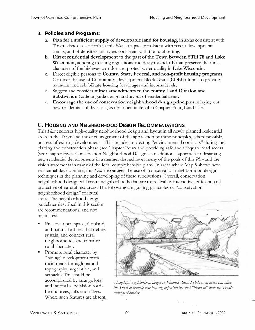
Town of Merrimac Comprehensive Plan Housing and Neighborhood Development
3. Policies and Programs: a. Plan for a sufficient supply of developable land for housing, in areas consistent with
Town wishes as set forth in this Plan, at a pace consistent with recent development trends, and of densities and types consistent with the rural setting.
b. Direct residential development to the part of the Town between STH 78 and Lake Wisconsin, adhering to siting regulations and design standards that preserve the rural character of the highway corridor and protect water quality in Lake Wisconsin.
c. Direct eligible persons to County, State, Federal, and non-profit housing programs. Consider the use of Community Development Block Grant (CDBG) funds to provide, maintain, and rehabilitate housing for all ages and income levels.
d. Suggest and consider minor amendments to the county Land Division and Subdivision Code to guide design and layout of residential areas.
e. Encourage the use of conservation neighborhood design principles in laying out new residential subdivisions, as described in detail in Chapter Four, Land Use.
C. HOUSING AND NEIGHBORHOOD DESIGN RECOMMENDATIONS This Plan endorses high-quality neighborhood design and layout in all newly planned residential areas in the Town and the encouragement of the application of these principles, where possible, in areas of existing development . This includes protecting “environmental corridors” during the platting and construction phase (see Chapter Four) and providing safe and adequate road access (see Chapter Five). Conservation Neighborhood Design is an additional approach to designing new residential developments in a manner that achieves many of the goals of this Plan and the vision statements in many of the local comprehensive plans. In areas where Map 5 shows new residential development, this Plan encourages the use of “conservation neighborhood design” techniques in the planning and developing of these subdivisions. Overall, conservation neighborhood design will create neighborhoods that are more livable, interactive, efficient, and protective of natural resources. The following are guiding principles of “conservation neighborhood design” for rural areas. The neighborhood design guidelines described in this section are recommendations, and not mandates:
� Preserve open space, farmland, and natural features that define, sustain, and connect rural neighborhoods and enhance rural character.
� Promote rural character by “hiding” development from main roads through natural topography, vegetation, and setbacks. This could be accomplished by arrange lots and internal subdivision roads behind trees, hills and ridges. Where such features are absent,
Thoughtful neighborhood design in Planned Rural Subdivision areas can allow the Town to provide new housing opportunities that "blend-in" with the Town's natural character.
VANDEWALLE & ASSOCIATES 91 ADOPTED: DECEMBER 1, 2004

Town of Merrimac Comprehensive Plan Housing and Neighborhood Development
the use of berms with natural plantings can also be effective. Examples of buffers are described in more detail in Chapter Three. Another method would be to discourage the development of “frontage lots” along roadways, as these have the greatest visual and traffic impacts. Smaller lots that are “clustered” in one portion of the property and accessed by a shared driveway will minimize the impact of roadside development. Finally, limiting the amount of land planned and zoned for intensive development uses along continuous stretches of town roads or county highways to limit “strip” development is another method of preserving rural character.
� Encourage housing on modest sized lots. Smaller lots that are “clustered” in buildable portions of a property will allow for greater protection of natural features and open space in other portions of the land. Often, rural lots can be as small as 1½ acres and still allow for safe disposal of sanitary waste. Figure 19 provides a visual comparison between a conventional subdivision and conservation neighborhood design on the same conceptual site.
VANDEWALLE & ASSOCIATES 92 ADOPTED: DECEMBER 1, 2004

Town of Merrimac Comprehensive Plan Economic Development
Economic Development
VANDEWALLE & ASSOCIATES 93 ADOPTED: DECEMBER 1, 2004

Town of Merrimac Comprehensive Plan Economic Development
VIII.ECONOMIC DEVELOPMENT This chapter contains background information, goals, objectives, policies and recommended programs to promote the retention, stabilization and growth of the economic base in Merrimac. As required by §66.1001, Wisconsin Statutes, this chapter includes an assessment of new businesses and industries that are desired in the community, an assessment of the area’s strengths and weaknesses with respect to attracting and retaining businesses and industries, and an inventory of environmentally contaminated sites.
A. EXISTING ECONOMIC DEVELOPMENT FRAMEWORK
1. Labor Force A community’s labor force is theAs of the 2000 census, there were 537 individuals in portion of the population age 16 the Town’s labor force, an increase from 394 in and older that is employed or1990. Of the Town’s 2000 labor force, 19 were available for work. The labor unemployed resulting in an unemployment rate of 2.4 force includes people who are in percent. Many Town residents are retired. The the armed forces, employed, community survey results indicate that over 28 percent unemployed, or actively seeking of the property owners are retired. employment.
2. Employment Trends and Local Jobs Trends in employment for the residents of the Town of Merrimac help to define the existing economic development framework. Over the last decade (from the 1990 to 2000 US Census), employment in the Town has shifted considerably. The number of residents of the Town employed in management, professional and related occupations increased over 170 percent. At the same time, the number of Merrimac residents employed in other sectors also increased over 30 percent. The notable exception is employment in farming, forestry, and fisheries operations which decreased by 78 percent in this ten-year time period.
Given its rural orientation, there are no major employers within the Town of Merrimac. Devil’s Head Resort and Convention Center, as well as many other small businesses provide local jobs. Primary employers within Sauk County include the Ho-Chunk Nation (1,737 jobs) and Lands End Inc. (1,100 jobs). Grede Foundries, Sysco Corporation, Perry Judd’s, Flambeau Corporation, and Cardinal IG Company each employ over 500 people. Combined, the public school districts and the County Government employ over 1,325 people. The major manufacturing employers in the County are catalog and consumer goods, food products, and commercial printing. Major non-manufacturing employers include tourism-related businesses, schools, and government.
VANDEWALLE & ASSOCIATES 94 ADOPTED: DECEMBER 1, 2004

Town of Merrimac Comprehensive Plan Economic Development
Figure 19: Sauk County’s Largest Industry Groups 2000
Employers Employment
% change in Employment
1995-2000
1. Eating and drinking places 133 2,415 +9% 2. Health services 64 2,388 +10% 3. Educational services1 N/A N/A -4. Miscellaneous Retail 65 1,736 +38% 5. Hotels and other lodging places 51 1,675 +37% 6. Rubber and misc. plastic products 10 1,414 -24% 7. Wholesale trade-Non-durable goods 38 1,352 +11% 8. Business services 31 1,207 +49% 9. Executive, legislative, and general 31 1,207 -5% 10. Primary metal industries 6 N/A N/A -
Department of Workforce Development 2002
3. Economic Development Programs There are a number of tools and programs available to foster economic development in Merrimac. Located in Baraboo, the Sauk County Development Corporation provides economic development assistance for the villages and town within Sauk County to help promote business recruitment to the area.
Grants are a second economic development tool. The Wisconsin Department of Commerce has a broad range of financial assistance programs to help communities undertake economic development. Grants for improvements of public infrastructure are available for economic development projects that bring quality jobs into the community. Specific grants the communities could apply for include the Community-based Economic Development Program Grant and the Community Development Block Grant (CDBG) Program – including the CDBG-Public Facilities Grant, and the CDBG-Public Facilities for Economic Development Grant. For further information on these and other economic development grants, contact the Wisconsin Department of Commerce.
Community Survey Results
When asked if Merrimac should promote more business
development: 21.8% strongly agreed
30.7% somewhat agreed 26.5% somewhat disagreed 21.0% strongly disagreed
1Because these industries represent three or fewer employers in the county, educational services and primary metal industries data is suppressed by the Department of Workforce Development to maintain confidentiality. Since educational services is ranked third, it can be assumed that this industry includes between 1,736 and 2,388 employees in Sauk County. It can also be assumed that 10-ranked primary metal industries employ less than 1,207 employees.
VANDEWALLE & ASSOCIATES 95 ADOPTED: DECEMBER 1, 2004
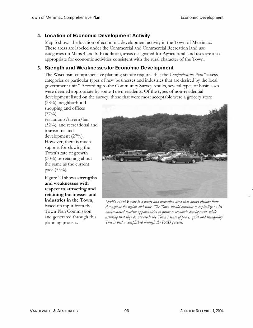
Town of Merrimac Comprehensive Plan Economic Development
4. Location of Economic Development Activity Map 5 shows the location of economic development activity in the Town of Merrimac. These areas are labeled under the Commercial and Commercial Recreation land use categories on Maps 4 and 5. In addition, areas designated for Agricultural land uses are also appropriate for economic activities consistent with the rural character of the Town.
5. Strength and Weaknesses for Economic Development The Wisconsin comprehensive planning statute requires that the Comprehensive Plan “assess categories or particular types of new businesses and industries that are desired by the local government unit.” According to the Community Survey results, several types of businesses were deemed appropriate by some Town residents. Of the types of non-residential development listed on the survey, those that were most acceptable were a grocery store (38%), neighborhood shopping and offices (37%), restaurants/tavern/bar (32%), and recreational and tourism related development (27%). However, there is much support for slowing the Town’s rate of growth (30%) or retaining about the same as the current pace (55%).
Figure 20 shows strengths and weaknesses with respect to attracting and retaining businesses and industries in the Town, Devil's Head Resort is a resort and recreation area that draws visitors from based on input from the throughout the region and state. The Town should continue to capitalize on its Town Plan Commission nature-based tourism opportunities to promote economic development, while and generated through this assuring that they do not erode the Town’s sense of peace, quiet and tranquility. planning process. This is best accomplished through the PAD process.
VANDEWALLE & ASSOCIATES 96 ADOPTED: DECEMBER 1, 2004

Town of Merrimac Comprehensive Plan Economic Development
Figure 20: Merrimac’s Strengths & Weaknesses for Economic Development
Strengths Weaknesses Highway 12 Expansion Highway 12 uncertainty Wisconsin River/Lake Wisconsin Limited industrial expansion opportunities The Merrimac Ferry Lack of technology infrastructure Community character Local competition for development Natural Resources Limited joint economic marketing programs Proximity to Madison Limited population base Natural lands and open space provide desirable backdrop for development (year-round and seasonal/recreational)
Uncertainty about Badger Army Ammunition Plant Re-Use
Population growth Natural resource impacts of development Nature-based tourism (e.g. Devils Lake, Parfrey’s Glen, Devil’s Head)
Environmental limitations
Badger Army Ammunition Plant Re-Use potential
6. Re-Use of Environmentally Contaminated Sites The WisDNR’s Environmental Remediation and Redevelopment Program maintains a list of contaminated sites, or “brownfields,” in the State. The WisDNR defines brownfields as “abandoned or under-utilized commercial or industrial properties where expansion or redevelopment is hindered by real or perceived contaminated.” Examples of a brownfield might include a large abandoned industrial site or a small corner gas station. Properties listed in the DNR database are self-reported, and do not necessarily represent a comprehensive listing of possible brownfields in a community.
Planning area sites represented on the WisDNR’s data base include three areas contaminated by spills. Other reported environmental issues were 6 leaking underground storage tanks. New sites throughout the state are added to the list regularly, and the possibility exists that more sites in the area will be listed in the future. These properties will need special attention for successful redevelopment to occur. The area support clean-up and appropriate reuse of these and other contaminated sties (when and if they are found), but should not approve (re)development project until remediation is completed or commitments are made for remediation.
B. ECONOMIC DEVELOPMENT GOALS, OBJECTIVES AND POLICIES
1. Goal: Allow for high-quality economic growth that supports farming, natural resource and rural character protection, and serves Town residents.
VANDEWALLE & ASSOCIATES 97 ADOPTED: DECEMBER 1, 2004

Town of Merrimac Comprehensive Plan Economic Development
2. Objectives: a. Focus economic development efforts on small scale activities and businesses that
promote farming, natural resource preservation and recreation, and generally preserve the rural character of the Town.
b. Discourage more intensive commercial and industrial uses. c. Work jointly with the Village of Merrimac and Sauk County on mutually beneficial
economic development initiatives.
3. Policies: a. Support the economic health of production agriculture in Merrimac. b. Support alternative forms of agriculture, such as vegetable and fruit farms and other
small acreage farms, research farming, community support agriculture, equine centers, businesses supporting hunting, fishing, and other outdoor recreational activities, and production of artisanal products such as wine and cheese. Consider ways to promote and market such farms and products, such as seminars, markets, “farm-days” and festivals.
c. Support opportunities for appropriate farm family businesses, home occupations, and agriculturally-related businesses to assist farm families.
d. Prevent unplanned, continuous strip commercial development along major roadways, particularly STH 78 and 113.
e. Direct larger scale commercial development serving the broader region to the Village of Merrimac.
f. Implement standards for commercial development to ensure that it is high-quality. g. Help small businesses and entrepreneurs access County and State economic funding
sources. h. Partner with the Village of Merrimac in order to attract businesses that are
appropriate for each community and work together on the joint marketing of the area.
VANDEWALLE & ASSOCIATES 98 ADOPTED: DECEMBER 1, 2004

Town of Merrimac Comprehensive Plan Intergovernmental Cooperation
Intergovernmental Cooperation
VANDEWALLE & ASSOCIATES 99 ADOPTED: DECEMBER 1, 2004
Town of Merrimac Comprehensive Plan Intergovernmental Cooperation
IX. INTERGOVERNMENTAL COOPERATION This chapter is focused on “intergovernmental cooperation”, or any formal or informal arrangement by which officials of two or more jurisdictions communicate visions and coordinate plans, policies, and programs to address and resolve land use, transportation, natural resource, utility or facility services, or other issues of mutual interest. In a state with over 2,500 units of government or special purpose districts, it is becoming increasingly important to coordinate decisions that affect neighboring communities in the comprehensive planning process.
This chapter contains a compilation of background information, goals, objectives, policies and recommended programs for joint planning and decision making with other jurisdictions, and covers all of the information required under §66.1001, Wisconsin Statutes. It is intended to promote consistency between this Plan and plans for neighboring jurisdictions.
A. EXISTING REGIONAL FRAMEWORK The Town of Merrimac is situated in a rich intergovernmental context. The Town is within Sauk County, but borders lands in Columbia County. In addition, much of the Town of Merrimac is comprised by the Badger Army Ammunition Plant and Devil’s Lake State Park, and therefore falls under the jurisdiction of federal and state agencies.
In summer 2004 the Town participated in an intergovernmental discussion as part of this planning process. Representatives from the Town, Village, and Sauk County were in attendance. Representatives from the other groups mentioned above were invited but were not in attendance at the meeting. This meeting provided a forum for all parties to share the outcome of their Comprehensive Planning processes to date, some of the major issues and opportunities being grappled with, and draft goals. The Town and Village also discussed their future land use concepts. In addition to this initial intergovernmental meeting, the Town invited representatives from the jurisdictions above to attend the Open House where the entire draft Comprehensive Plan was considered.
Considering the planned land uses in the Town in relation to its neighbors, most of the central portion of the Town is recommended to remain in long-term agricultural preservation. Lands east of Devil’s Lake State Park and north of Highway DL, near Devil’s Head Resort, are proposed for recreation-commercial development. Lands south and east of Highway 78 along the Wisconsin River/Lake Wisconsin are proposed for rural subdivision development. The remaining areas of the Town are recommended for agricultural preservation.
Currently, the Town is not party to any plans or agreements under §66.0307 or §66.0309, Wisconsin Statutes. The Town is party to general cooperative agreements for fire, rescue, road maintenance, and other services with Sauk County and neighboring communities under §66.0301.
1. Village of Merrimac The Village of Merrimac and the Town have a close historical arrangement. The Village borders Lake Wisconsin and shares the Town’s southern boundary. The Village has been growing at about 1/3 the rate of the Town over the last decade. Much of the Village is already built-out – as of 2000 the Village had about 220 housing units. At the time this Plan was written, the Village was engaged in a process to write a Comprehensive Plan under the State’s planning legislation. The Village’s existing Comprehensive Plan recommends working
VANDEWALLE & ASSOCIATES 100 ADOPTED: DECEMBER 1, 2004

Town of Merrimac Comprehensive Plan Intergovernmental Cooperation
with the Town to establish extraterritorial zoning. Other significant recommendations of the plan include promoting the development of a bridge across Lake Wisconsin to connect the two sections of STH 113. The development plan recommends that the Village focus primarily on recreational and commercial development. The plan suggests the Village create a new Residential Recreation zoning district that allow for condominiums, vacation homes, golf course resorts, bed and breakfasts, hotels, and smaller restaurants. In addition, the Village considered creating a commercial recreation district that provides for a wide variety and intensity of tourist oriented uses.
The residential recreation use is proposed for the northeastern section of the Village. The north central and northwestern sections of the Village are planned for commercial/recreation uses. These areas are currently undeveloped.
The plan also recommends extended Lake Street to connect with Bluff Road – increasing access to Devil’s Head and other attractions. Light industrial uses are also considered for the area north of the railroad tracks and west of the cemetery. There are no apparent existing or potential conflicts with this Plan, however the Town and Village should engage in more frequent intergovernmental discussions to ensure that the potential for future conflict is minimized.
2. Town of Sumpter The Town of Sumpter shares Merrimac’s western boundary. In 2003, the Town of Sumpter adopted a “smart growth” Comprehensive Plan, which updated the 1987 Town of Sumpter Development Plan. The purpose of the Town of Sumpter Comprehensive Plan is to “preserve agricultural land and protect farm operations as well as environmentally sensitive areas.” Only one house per is allowed for every 35 acres in the Exclusive Agriculture Zoning District. The Plan advocates the use of clustering for non-farm development of 3 residents or less. Additionally, the Plan recommends a residential density for additional development in the Bluffview area that is currently served by utilities. There are no apparent existing or potential conflicts with this Plan.
3. Town of Greenfield The Town of Greenfield is located to the north of Merrimac. The goal of the Town of Greenfield Land Use Plan is to maintain and manage the “overall economic resources and scenic character of the township, while retaining its rural agrarian atmosphere.” The Town is located directly east of the City of Baraboo. New commercial, industrial, and residential development is generally encouraged to locate adjacent to the City of Baraboo and be served by public utilities. The Town of Greenfield Land Use Plan Map includes seven land use categories: floodplain/wetland, bluff vista conservation (steep slopes and visible bluffs), prime farmland (Class I, II, and III soils), general agriculture (Class IV soils), public property, small lot residential (land zoned for residential subdivision at time of plan adoption), and tourism commercial (land zoned for commercial-recreation at time of plan adoption). There are three areas mapped for small lot residential development: north of Devil’s Lake State Park between Neuman Road and Highway W, east of Devil’s Lake State Park on the north side of Tower Road, and on the north side of Man Mound Road between Highway T and Rocky Point Road. One area of “tourism commercial” development is located on the south side of Luebke Road on the east Town line. At the time this Plan was
VANDEWALLE & ASSOCIATES 101 ADOPTED: DECEMBER 1, 2004

Town of Merrimac Comprehensive Plan Intergovernmental Cooperation
written, the Town of Greenfield was updating its Comprehensive Plan. There are no apparent existing or potential conflicts with this Plan.
4. Town of Baraboo Sharing a small portion of Merrimac’s northwestern boundary is the Town of Baraboo. The Town of Baraboo Development Plan identifies recommended areas for development and preservation. Generally, land north of the City of Baraboo to Goerks Road, between Terrytown Road and the eastern edge of the town, is identified for rural residential development on private on-site waste disposal systems with lots of at least 1 ½ acres in area. The Plan also recommends rural residential development generally east of Highway 123, between the City of Baraboo and Devil’s Lake State Park. Areas for new commercial development are located along Highway 12, north of the Village of West Baraboo. The Plan identifies various locations for planned recreational-commercial development along Highways 159 and 123 near Devil’s Lake State Park. Most of the remainder of the Town is recommended for long-term farmland preservation. The Plan does anticipate a possible future need for multi-family housing, but restricts this type of development to Sanitary District #1, located south of the City of Baraboo, or any future Sanitary District within the town. At the time this Plan was written, the Town of Greenfield was updating its Comprehensive Plan. There are no apparent existing or potential conflicts with this Plan.
5. Town of Prairie du Sac The Town of Prairie du Sac was in the process of preparing a Comprehensive Plan concurrently with the Town of Merriac. The emphasis of Prairie du Sac’s plan is on continued agricultural and natural area preservation. A vast majority of the Town will be planned for continued “exclusive agricultural” use. This includes all lands near the Town of Merrimac west of Highway 78. The Town is refining its policies for limited non-farm development within these areas, including provisions for clustering and potentially for requiring very large minimum lot sizes where clustering is not used. East of 78, along Lake Wisconsin/Wisconsin River, the draft plan calls for rural single family residential development northeast of the railroad tracks and village single family residential development southwest of the railroad tracks. There are no apparent existing or potential conflicts with this Plan.
6. Town of West Point Located in Columbia County, the Town of West Point lies south of Merrimac. The Town of West Point Land Use Plan was last updated in June of 1996. The Plan divides the Town into 4 planning districts: Lakeshore Development District, Recreation District, Transitional Development Expansion District, and Agricultural and Woodland Preservation District. The Lakeshore Development District is the preferred area for non-farming residences. Both commercial and industrial uses are not permitted in this district. The Plan prohibits both subdivision within the Agricultural and Woodland Preservation District and the creation of new lots less than 35 acres. Only one home per every 35 acres of farmland is allowed. There are no apparent existing or potential conflicts with this Plan.
7. Town of Caledonia The Town of Caledonia Land Use Goals, Objectives and Policies document was adopted in 1996. It is a set of policies that recommends preserving the rural look and feel of the Town by limiting
VANDEWALLE & ASSOCIATES 102 ADOPTED: DECEMBER 1, 2004

Town of Merrimac Comprehensive Plan Intergovernmental Cooperation
residential and commercial development. The goals, objectives and policies of the Town of Caledonia are consistent with the goals and recommendations of the Town of Merrimac Comprehensive Plan. Caledonia will be updating its land use planning controls by preparing a comprehensive plan, participating with Columbia County in its planning process. There are no apparent existing or potential conflicts with this Plan.
8. Sauk County In 1999, the Sauk County Board of Supervisors adopted the Sauk County 20/20 Development Plan. The Development Plan is a policy document that presents vision statements, goals, and policies on six major planning areas, including community change, economic development, farmland preservation, housing, natural resources, and transportation. This plan does not include a county future land use map. The plan does recommend that the county prepare comprehensive rewrites of its Zoning Ordinance and Land Division and Subdivision Ordinance to reflect the values of its 20/20 Plan. It also recommends that the county study innovative land use approaches, such as purchase of development rights, transfer of development rights, and conservation subdivision design as ways to preserve farmland and natural resource areas while respecting private property rights. Finally, the plan recommends that the county adopt an erosion control/stormwater management program, a groundwater protection program, and a highway access control ordinance.
The Sauk County Farmland Preservation Plan was adopted in 1979. The plan sets forth four primary policies: 1) To preserve lands that are in agricultural use, those that contain Class I, II, III, or IV soils, or those that are of adequate size to maintain efficient farm operations; 2) To limit growth areas adjacent to or within platted areas; 3) To encourage public facilities to locate within existing utility and transportation corridors; and 4) To encourage the preservation of significant natural resources, open space, scenic, historic, or architectural areas by identifying areas to be considered for preservation. There are no apparent existing or potential conflicts with this Plan.
9. Columbia County At the time of writing, Columbia County was prepared to update its Land Use Plan, which was adopted in 1970, to meet comprehensive planning requirements.
The Columbia County Agricultural Preservation Plan was originally adopted in 1977, and updated in 1998. This plan supports the basic goal of preserving farmland and lays the foundation for the County’s agricultural zoning, which was also adopted in 1977.
The Columbia County Land and Water Resource Management Plan was adopted in 1999. This plan contains a comprehensive assessment of County resources, and goals and strategies to manage these resources. There are no apparent existing or potential conflicts with this Plan.
10. Important State and Federal Agency Jurisdictions The Wisconsin Department of Transportation (WisDOT) District 1 office (Madison) serves Merrimac and all of Sauk County. WisDOT plans are summarized in Chapter 5.
Wisconsin Department of Natural Resources (WisDNR) provides services in the area including operation and management of Devil’s Lake State Park and Parfrey’s Glen and Lake Wisconsin patrols.
VANDEWALLE & ASSOCIATES 103 ADOPTED: DECEMBER 1, 2004

Town of Merrimac Comprehensive Plan Intergovernmental Cooperation
Lower Wisconsin Riverway Board works to protect and preserve the scenic beauty and natural character of the Lower Wisconsin River through land use and development control. Merrimac should work with the Board to ensure future land use conflicts do not arise around the river.
The US Dairy Forage Research Center is a part of the US Department of Agriculture Agricultural Research Service (USDA-ARS). ARS is the principal scientific research arm of the United States Department of Agriculture. The USDFRC has a research laboratory on the campus of the University of Wisconsin-Madison and a dairy research farm located in the Town of Merrimac.
The National Park Service administers the existing 4 mile stretch of the Ice Age Trail in the Town of Merrimac, and is eager to work with representatives from the Town, Village, and County to link these portions of the trail in the Town – ultimately linking the Merrimac Ferry to Devils Lake State Park.
There are no apparent existing or potential conflicts with this Plan.
11.Badger Army Ammunition Plant Badger Army Ammunition Plant (BAAAP) is located on 7,354 acres of land, bordered on the north by Devil's Lake State Park, on the east by the Town of Merrimac and STH 78, and the Wisconsin River, on the south by farmland, and on the west by U.S. Highway 12. Badger was constructed in 1942, operated intermittently over a 33-year period to produce single- and double-base propellant for cannon, rocket, and small arms ammunition. Plant operation was terminated in March 1975 and all production facilities and many support functions were placed on standby status, which continued until 1998. Badger is currently inactive and had been maintained on standby since 1976.
In 2002, an intergovernmental agreement was formed between the Wisconsin Department of Natural Resources, the Ho-Chunk Nation, Sauk County, the Town of Merrimac and the Town of Sumpter. Other signatories to this Agreement are the United States Department of the Interior, the Bureau of Indian Affairs and the General Services Administration. This agreement was created to serve the public interest in implementing the values and criteria of the Badger Reuse Plan.
The task of the Committee formed by the intergovernmental agreement was to develop “a common vision for the reuse of the Badger property that can be meaningfully considered and realistically implemented by the appropriate local, state and federal agencies.” In 2002 the Committee favored awarding sole ownership of the property, but since that time the General Services Administration (GPA) has sought to split ownership between the Wisconsin DNR, the Wisconsin Department of Agriculture- Dairy Forage Research Center, and the Ho-Chunk Nation. At the time this Comprehensive Plan was written, the details of the Badger Reuse Plan were still under negotiation. If Badger is ultimately used for something other than low-impact, conservation and/or agricultural uses, it may conflict with this Plan in the future.
12.Sauk Prairie School District The Sauk Prairie School District serves the southern and eastern portions of the Town of Merrimac and also includes the Villages of Merrimac, Prairie du Sac, and Sauk City, and the Towns of Honey Creek, Prairie du Sac, Sumpter, and Troy. There are no known conflicts
VANDEWALLE & ASSOCIATES 104 ADOPTED: DECEMBER 1, 2004
Town of Merrimac Comprehensive Plan Intergovernmental Cooperation
between the Town of Merrimac Comprehensive Plan and the various adopted plans and policies of the Sauk Prairie School District. There are no apparent existing or potential conflicts with this Plan.
13.Baraboo School District The Baraboo Public School District, serving the northern portion of the Town, as well the City of Baraboo, Villages of West Baraboo and North Freedom, the Towns of Baraboo, Fairfield, and Greenfield; and portions of the Towns of Delton, Excelsior, Freedom, and Sumpter. There are no known conflicts between the Town of Merrimac Comprehensive Plan and the various adopted plans and policies of the Baraboo School District. There are no apparent existing or potential conflicts with this Plan.
B. INTERGOVERNMENTAL COOPERATION GOALS, OBJECTIVES AND POLICIES
1. Goal: Develop mutually beneficial relations with nearby governments.
2. Objectives: a. Work with the Village of Merrimac, neighboring Towns, Sauk County, and Columbia
County, school districts, and state agencies on service delivery and issues of mutual concern.
b. Explore the possibility of pursuing cooperative economic development initiatives with the Village that would benefit both communities.
c. Stay informed and work with Sauk County and neighboring jurisdictions to the extent possible on their ongoing comprehensive and transportation planning efforts.
3. Policies and Programs: a. Provide a copy of this Comprehensive Plan to all surrounding local governments. b. Identify any differences between the Town of Merrimac Comprehensive Plan and
those of neighboring communities, working to resolve incompatible planned land uses where and when feasible.
c. Consider joint services and facilities where consolidating, coordinating, or sharing will result in better services and/or lower costs of provision, for instance provision of police, ambulance and emergency protection services.
d. Cooperate with other units of government, including the Village of Merrimac, Sauk County, and the State on natural resources, recreational venues, transportation facilities, and other systems that are under shared authority or cross jurisdictional boundaries.
e. Consider an intergovernmental agreement with the Village of Merrimac to forward joint service and facility provision and cooperative implementation of addition plan elements.
f. Establish regular, formal discussions of issues of mutual concern with the Village of Merrimac.
g. Continue to participate in and provide input on the reuse of the Badger Army Ammunition Plant, emphasizing restoration of the natural character of the landscape and environmental remediation of contaminated sites.
h. Encourage landowners to continue to enroll in County, State, and non-profit sponsored programs for land preservation – including the Baraboo Range
VANDEWALLE & ASSOCIATES 105 ADOPTED: DECEMBER 1, 2004

Town of Merrimac Comprehensive Plan Intergovernmental Cooperation
Preservation Program, the Baraboo Range Preservation Association, and State Stewardship funding. These are discussed in greater detail in Chapter 2.
i. Work with the WisDNR and WisDOT to allocate funding toward development of a parking area for the Lake Wisconsin access at Weigands Bay.
j. Work with the National Park Service, WisDNR, Sauk County, and the Village of Merrimac to complete the Ice Age National Scenic Trail through the Town and Village – linking Devils Lake State Park with the Merrimac Ferry.
VANDEWALLE & ASSOCIATES 106 ADOPTED: DECEMBER 1, 2004

Town of Merrimac Comprehensive Plan Implementation
IMPLEMENTATION
VANDEWALLE & ASSOCIATES 107 ADOPTED: DECEMBER 1, 2004

Town of Merrimac Comprehensive Plan Implementation
X.PLAN IMPLEMENTATION Few of the recommendations of this comprehensive plan will be automatically implemented. Specific follow-up action will be required for the plan to become reality. This final chapter of the plan is intended to provide Merrimac with a roadmap for these implementation actions. It includes a compilation of programs and specific actions to be completed in a stated sequence, as required under §66.1001, Wisconsin Statutes.
A. PLAN ADOPTION The Town of Merrimac Comprehensive Plan was adopted following procedures specified by Wisconsin’s “Smart Growth” legislation. The Town included all necessary elements for this Plan to meet all content requirements of the law, including grant program requirements. In addition, the Town met and exceeded all procedural requirements of the law. This included extensive public input throughout the process, a Town Plan Commission recommendation, distribution of the recommended Plan to affected local governments, a formal public hearing, and Town Board adoption of the Plan by ordinance. After Town adoption, this Plan was also forwarded to the County.
B. IMPLEMENTATION RECOMMENDATIONS Figure 21 provides a detailed list and timeline of the major actions that Merrimac should complete to implement the comprehensive plan. Often, such actions will require substantial cooperation with others, including County government and local property owners. The figure has three different columns of information, described as follows:
� Category: The list of recommendations is divided into six different categories—loosely based on the different chapters of this plan.
� Recommendation: The second column lists the actual steps, strategies, and actions recommended to implement key aspects of the comprehensive plan. The recommendations are for town actions, recognizing that many of these actions may not occur without cooperation from others.
� Implementation Timeframe: The third column responds to the new state comprehensive planning statute, which requires implementation actions to be listed in a “stated sequence.” The suggested timeframe for the completion of each recommendation reflects the priority attached to the recommendation.
VANDEWALLE & ASSOCIATES 108 ADOPTED: DECEMBER 1, 2004

Town of Merrimac Comprehensive Plan Implementation
Figure 21: Implementation Strategies Timetable
Category Recommendation Implementati on Timeframe
Agricultural, Natural, and Cultural Resources
Encourage the preservation of historically and architecturally significant structures/districts and archeological resources in the Town.
2005 and ongoing
Continue to work with WisDNR to monitor wells for groundwater contamination Ongoing
Include a Natural Resources Zoning Overlay District in the Town zoning ordinance to protect woodlands, slopes, drainageways, and other natural features 2005
Continue to work with Sauk County on monitoring and mitigating existing and potential nonpoint source pollution Ongoing
Work with the Village, County, State, and NPS to establish a link between existing segments of the Ice Age Trail in the Town 2005 - 2006
Land Use Require the submittal of a conceptual/sketch plan or site plan for a specific development proposal before approving the rezoning of land to the appropriate development-based zoning district.
2005 and ongoing
Prepare a complete update of this Comprehensive Plan 2010 Revisit Town zoning ordinance to ensure that it is implementing the safeguards the Town envisions for Agricultural and Resource Preservation areas 2005
Work with neighboring communities, the County, State, and federal agencies on the re-use plan for Badger Army Ammunition Plant Ongoing
Transportation Create and implement a Town Road Improvement Program. 2005 and ongoing
Work with the State DOT to preserve rural character, access, and safety along STH 78
2005 and ongoing
Work with the State DOT and DNR to create a parking and access to Lake Wisconsin at Weigands Bay adjacent to STH 78. 2007 -2009
Utilities and Community Facilities
Cooperate with the Village of Merrimac on service agreements and improvements to the Fire Department and EMS service As needed
Work with the Sauk Prairie School District and the Village on retaining Merrimac Elementary School 2005 - 2008
Housing & Economic Development
Follow Plan standards for all development projects. Ongoing Update zoning ordinance to implement desired Highway setbacks from new residential areas 2005
Intergovernmental Cooperation
Provide a copy of this Comprehensive Plan to all surrounding local governments, per Smart Growth requirements. 2005
Encourage County Board adoption of the Plan. Because of shared land use authority, it is very important that the Town and County share the same plan for the same area.
2005
Complete portions of Ice Age Trail linking existing segments By 2010 Work to resolve conflicts between the Town of Merrimac Comprehensive Plan and plans of surrounding communities. Ongoing
VANDEWALLE & ASSOCIATES 109 ADOPTED: DECEMBER 1, 2004

Town of Merrimac Comprehensive Plan Implementation
C. PLAN MONITORING, AMENDMENTS, AND UPDATE The Town should regularly evaluate their progress towards achieving the recommendations of the comprehensive plan, and amend and update the plan as appropriate. This section suggests recommended criteria and procedures for monitoring, amending, and updating the plan.
1. Plan Monitoring The Town Plan Commission should, on an annual basis, review its decisions on private development proposals over the previous year against the recommendations of this Plan. This will help keep the Plan a “living document.”
The Town should constantly evaluate its decisions on private development proposals, public investments, regulations, incentives, and other actions against the recommendations of this Comprehensive Plan.
Before submitting a formal application to the Town and/or County for approval of any development proposal, the Town urges petitioners to discuss the request conceptually and informally with the Town Plan Commission. Conceptual review almost always results in an improved development product and can save the petitioner time and money.
2. Plan Amendments Amendments to this Comprehensive Plan may be appropriate in the years following initial Plan adoption and in instances where the Plan becomes irrelevant or contradictory to emerging policy or trends. “Amendments” are generally defined as minor changes to the Plan maps or text. The Plan should be evaluated for potential amendments during the Town’s annual review described above. Frequent amendments to accommodate specific development proposals should be avoided.
The State comprehensive planning law requires that the Town use the same basic process to amend, add to, or update the Comprehensive Plan as it used to initially adopt the Plan. This does not mean that new vision forums need to be held, old committees need to be reformed, or recent relationships with adjacent communities need to be reestablished. It does mean that the procedures defined under Section 66.1001(4) and Chapter 91, Wisconsin Statutes, need to be followed. Specifically, the Town should use the following procedure to amend, add to, or update the Comprehensive Plan:
a. Either the Town Board or Plan Commission initiates the proposed Comprehensive Plan amendment. This may occur as a result of a regular Plan Commission review of the Plan, or may by initiated at the request of a property owner or developer.
b. The Town Board adopts a resolution outlining the procedures that will be undertaken to ensure public participation during the plan amendment process (see Section 66.1001(4)a of Statutes and model resolution included in this Comprehensive Plan).
c. The Town Plan Commission prepares or directs the preparation of the specific text or map amendment to the Comprehensive Plan.
d. The Town Plan Commission holds one or more public meetings on the proposed Com-prehensive Plan amendment. Following the public meeting(s), the Plan Commission shall make a recommendation by resolution to the Town Board by majority vote of the entire Commission (see Section 66.1001(4)b of Statutes and model resolution in this Plan).
e. The Town Clerk sends a copy of the recommended plan amendment (not the entire Comprehensive Plan) to all adjacent and surrounding government jurisdictions and the
VANDEWALLE & ASSOCIATES 110 ADOPTED: DECEMBER 1, 2004

Town of Merrimac Comprehensive Plan Implementation
County as required under Section 66.1001(4)b, Wisconsin Statutes. Metallic mine operators, any person who has registered a marketable nonmetallic mineral deposit with the local government, and any other property owner of leaseholder who has requested notification in writing must be informed through this notice procedure. These governments and individuals should have at least 30 days to review and comment on the recommended plan amendment.
f. The Town Clerk directs the publishing of a Class 1 notice, with such notice published at least 30 days before a Town Board public hearing and containing information required under Section 66.1001(4)d, Wisconsin Statutes.
g. The Town Board holds the formal public hearing on an ordinance that would incorporate the proposed plan amendment into the Comprehensive Plan.
h. Following the public hearing, the Town Board approves (or denies) the ordinance adopting the proposed plan amendment. Adoption must be by a majority vote of all members. The Town Board may require changes from the Plan Commission recommended version of the proposed plan amendment.
i. The Town Clerk sends a copy of the adopted ordinance and plan amendment (not the entire Comprehensive Plan) to all adjacent and surrounding government jurisdictions as required under Sections 66.1001(4)b and c, Wisconsin Statutes.
j. The Town Clerk sends copies of the adopted plan amendment to the Sauk County Planning and Development Department for their reference for Town goals and policies.
3. Plan Update The State comprehensive planning law requires that the Comprehensive Plan be updated at least once every ten years. As opposed to an amendment, an update is often a substantial re-write of the plan document and maps. Further, on January 1, 2010, most programs or actions that affect land use, like zoning and subdivision decisions, will have to be consistent with locally-adopted comprehensive plans. Based on these two deadlines, the Town should complete a full update its Comprehensive Plan before the year 2014 (i.e., ten years after 2004) at the latest and prepare and update recommended ordinances before 2010. The Town should continue to monitor any changes to the language or interpretations of the State law over the next several years.
D. CONSISTENCY AMONG PLAN ELEMENTS The State comprehensive planning statute requires that the implementation element “describe how each of the elements of the comprehensive plan shall be integrated and made consistent with the other elements of the comprehensive plan.” Preparing the various elements of the Town of Merrimac Comprehensive Plan simultaneously has ensured that there are no known internal inconsistencies between the different elements of this Plan.
VANDEWALLE & ASSOCIATES 111 ADOPTED: DECEMBER 1, 2004

Town of Merrimac Comprehensive Plan Implementation
VANDEWALLE & ASSOCIATES 112 ADOPTED: DECEMBER 1, 2004

Adopted: December 1, 2004
(/
-~0,0
"~!~~
..........
G
...•..........
j
()
~I-
L-
~
()
-
COLUMBIA COUNTY
""-'
j~.'.'w .'w •(f)
w
~k()c~
" w ~ -~. goiii· lJu,(f) nn ~
0~
Q. Q. ~w;/ii,~..
0 0
f in' ,~,~§" s." IT Q. ,•
D(J
o
-
r-.....
o
.fd(\~ _ .
7
J_f
e-
Lc)fcnd
School District Boundaries
Section Boundaries f NumbersTown ofMern'mac
Comprehensive Plan
Jurisdictional Boundaries
~ Unit~d Stat~s Highways
- State Highways
~ County HighW<lYs
---~ Highway 78 Re-alignm"'nt
- Railroad
c:::l County Boundaries
o Municipal Boundaries
•
..........
Sources:us Ccmus BureauTIGER Line Piles.Based OIl the 2000 census.
Baraboo Range National Natural Landmark I)a1a provided byVandewalle and ASSOLiales ~.
" .. /~ . " "
",
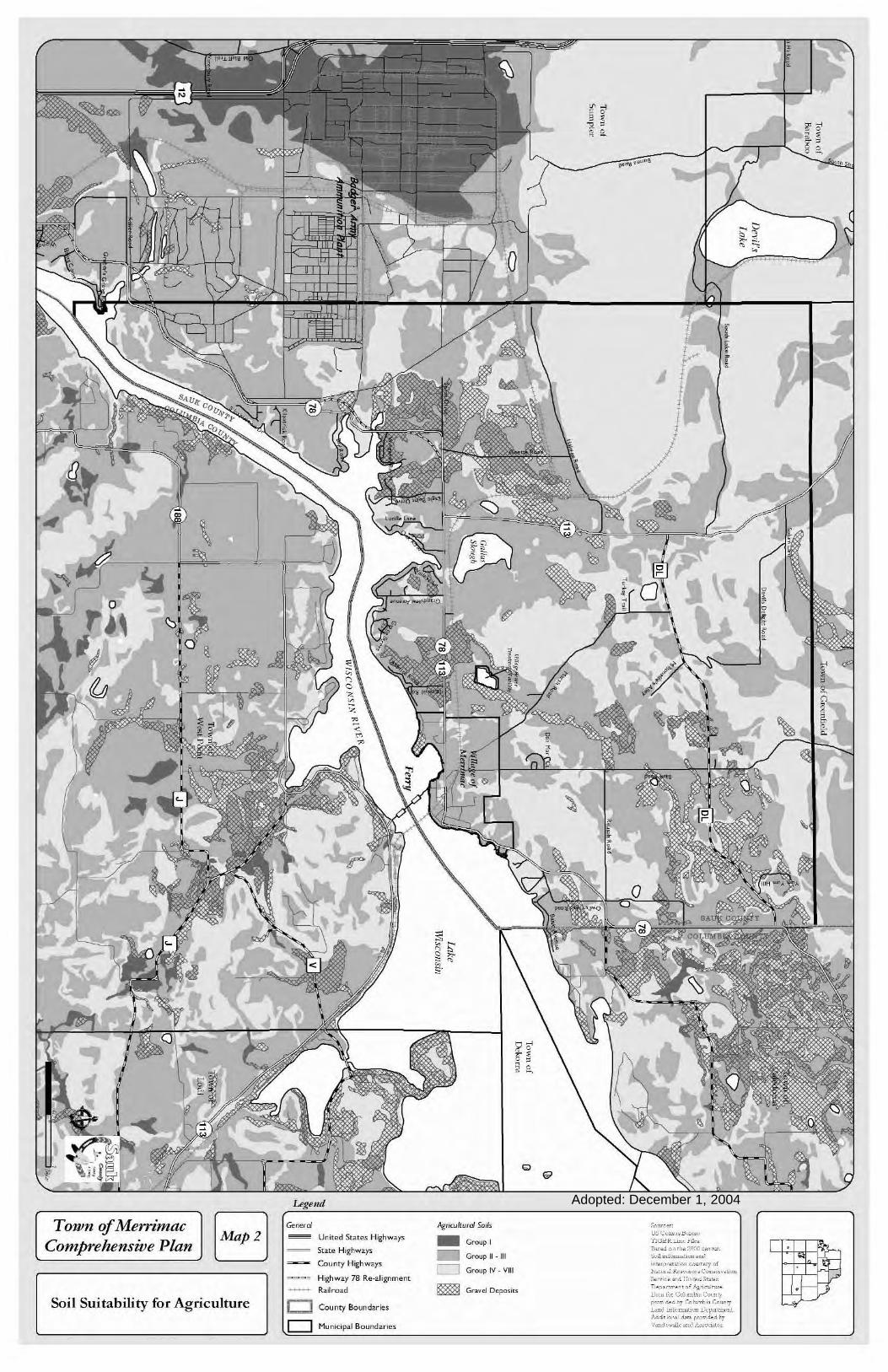
Adopted: December 1, 2004
tI, "
o
\
Legelld
Town ofMerrimacComprehensive Plan
Soil Suitability for Agriculture oo
United States HighwaY'
State HighwaY'
County Highways
Highway 78 Re-alignment
Railroad
County Boundaries
Municipal Boundaries
Agrirullurd Soils
_ Group I
_ GroupU-UI
c::::::J Group IV - VUI
~ Gr,..,.! D~po.iu
So""..w:; C"".." H,.,,,,"'l'lGJOR.L>""!'>!,,,,n.".dM,h.W0:1,.o"",
Soil ",lC"",.tw" u~1
"""P"'''''00 '0m,,"l' ofNolc<.u &'.0'.',-' C0n"',,",,unSo",,,. ~,d 1J",,,,d ott,."n.p.""""' of "',,0>1,,_,,<l,M. 1'-" Ccl,.~[". C0mt,p'0~,,,... dby '",I"mb,. ,-,mo",
J,.omI1nl'"u,""-",, J,.kp"'tu~·nt
Ad", ,o",1 d~,,- rco~,d.d byVoal ,,,,>II,, oml ill"-",.<..,,,
I
8.1-
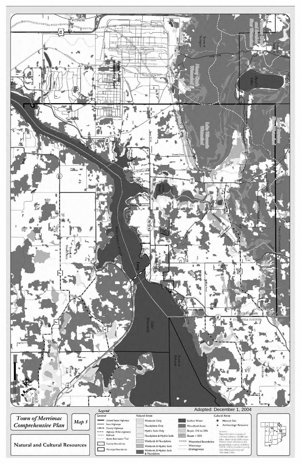
Adopted: December 1, 2004
r •
Town ofMerrimacComprehensive Plan
Natural and Cultural Resources
UnUd S"'~, Highw.Y'
SD.[C Hizn-Y'
County Highw.Y'
Higllw.y 78 Re-.lignm..,'-+-H-+- R.ilro.d
Ac<ivc Rc,rcaIion T...l
i • County Boundar;',
o Munidpol Boundari~,
Nawrol Ar"'as
o W"t1and. Only
o Floodpl3in. Only
o Hydric Soil. Only
o Floodpl3in. & Hydric Soil<
o W&land. & Floodpbin.
_ W&land. & Hydric Soil<
_ W&land. & Hydric Soil<& Floodplain.
_ Surfuc" W>t"r
_ Woodbnd Ar~""
~ Slop"" 12% to 20%
~:S1op"">20%
-.,.,., Watershed Boundaries
Wat~rway.
Drainagcways
Cultural Ar"'as
Hi<toric Sit"
.Jr. Archa~ologi<. R~.ourc~
C0c"C'C"'D"". i"fNm.M, O0"''''J 0fVS Cmm.Il"H'," 'l'lGERJ..u,,'bk~ h,,·J un the- 2000 c..m"~N""",I "CO"" ;,fmm,non .nd"lc~p'C'",u"" c'c>c"lc.y 01- NIlS;S,n;nA, 1JSGS, (01umN.Coun'J',St.le .H"t0U'-.l S"ndl .mdWllicun",nUNR
. Its~
-'"

Adopted: December 1, 2004 Legmd
Town ofMerrimacComprehensive Plan
Existing Land Use
Grne-al
_ lJn;tti! s-.. Hi\:h...Y'
Stot,e Highwoy>
County Highwoy>
Highwoy 78 Ro••ligr.-nont
++++ Ra• ...-I
Ic. AJ;. T.-d
t::J County !lord• .
o Mun~;pol !lord."
Land Us.
o Rural Residential
_ Rural Subdivision
o Village Residential_ Commercial
_ Recreation Commercial
_ Institutional
o Industrial
o Agriculture or Undeveloped Lands
_ Preserved Public Open Spaces
_ Preserved Private Open Spaces
_ Mineral Extraction
o Surface Water
e""m·,: .. rU'C,m..~IJ",c ....,'j'IGIiK.Lu~,j"il, ...1J 'm!um",Uun "·u,,,le., ~ I., d,nu,""0n~tiK,,,11J ,d un U,~~~~=II.~~~'~~:,,,,.,"d mmf' '"

Adopted: December 1, 2004
o
Q
"00'Land~1I BlJIfer
land~11L
0000
Active' !naClivc I..nndfills
Roadside IShor~land Bu1f~r
Propo,ed General--.. Trail Corridor
~"" Environmental Corridor Area
Qo
Planned Land Use
o Rural Subdivision
_ Commercial
_ Recreation Commercial
o Agricultural PreservatK>n_
d Public Open Spaces
Preserve So"m". _ fW Coo,,,,, nmuu T1GTm !;".I'i"
-
Conservation n.,.'"fN~'';;,;:"::0!.~,~,,,.~fmm"M"K"h".dn.,.d0" ,,. - Y",'J~~;lk ""J li"'c>c"k>o Surface Water ""J c-uu,!,ildby
U,Md S",,,,, Hil;hwaY'
St.", HEnwoY'
Co,",,>, H;p,_y>
Hi&nwoy 78 R.-dEnm...
+-+-++- Rairood
bAgo Trail
j 1Coooty 8o~~r
o I"kJnicipoi Botd ....
Gcneml
" :-..:,' "_ 1"-'.LJI"Ia PlO
G
(]
o
Town f!fMerrimacComprehensive Plan
[ Planned Land Use

Adopted: December 1, 2004
(/
-~0,0
"~!~~
..........
G
...•..........
j
()
~I-
L-
~
()
-
COLUMBIA COUNTY
""-'
j~.'.'w .'w •(f)
w
~k()c~
" w ~ -~. goiii· lJu,(f) nn ~
0~
Q. Q. ~w;/ii,~..
0 0
f in' ,~,~§" s." IT Q. ,•
D(J
o
-
r-.....
o
.fd(\~ _ .
7
J_f
e-
Lc)fcnd
School District Boundaries
Section Boundaries f NumbersTown ofMern'mac
Comprehensive Plan
Jurisdictional Boundaries
~ Unit~d Stat~s Highways
- State Highways
~ County HighW<lYs
---~ Highway 78 Re-alignm",nt
- Railroad
c:::l County Boundaries
o Municipal Boundaries
•
..........
Sources:us Ccmus BureauTIGER Line Piles.Based OIl the 2000 census.
Baraboo Range National Natural Landmark I)a1a provided byVandewalle and ASSOLiales ~.
" .. /~ . " "
",

Adopted: December 1, 2004
tI, "
o
\
Legelld
Town ofMerrimacComprehensive Plan
Soil Suitability for Agriculture oo
United States HighwaY'
State HighwaY'
County Highways
Highway 78 Re-alignment
Railroad
County Boundaries
Municipal Boundaries
Agrirullurd Soils
_ Group I
_ GroupU-UI
c::::::J Group IV - VUI
~ Gr,..,.! D~po.iu
:>0""""w:; C"".." H,.,,,,"'l'lGJOR.L>""!'>!,,,,n.".dM,h.W0:1,.o"",
Soil ",lC"",.tw" u~1
"""P"'''''00 '0m,,"l' ofNolc<.u &'.0'.',-' C0n"',,",,unSo",,,. ~,d 1J",,,,d ott,."n.p.""""' of "',,0>1,,_,,<l,M. 1'-" Ccl,.~[". C0mt,p'0~,,,... dby '",I"mb,. ,-,mo",
J,.omI1nl'"u,"""" J,.kp"'tu~·nt
Ad", ,o",1 d~,,- rco~,d.d byVoal ,,,,>II,, oml ill"-",.<..,,,
I
8.1-

Adopted: December 1, 2004
,,-,
-.
'.
1
=
•
Town ofMerrimacComprehensive Plan
N anlral and Cultural Resources
e;,.,n~r<J!
Uoit<d s""~, High..·."
Sol", H;~"w.)'
CO""'y Higo""I'
High....'r 78 h-,lig<1m",,'--++- ll.>il",.d
l=:J CO""" Bound,,,,,,
D M~ni<:rp"1 Bounwri.,
Nalu,al Ar~<Is
_ W~d.nd, Only
o Flood;>I,;n, Only
o Hydr;c Soil, Only
o Flood;>I,;n, & Hydric Scit<
_ W~d>nd< & Flood;>!>;n,
_ W~<I.nd, & Hydric Sci"
_ W~<I.nd, & Hydric Sci"& Floodplains
_ s...rfac~ W>tu
_ Wocdbnd Ar~"
~ Slo~' 12% '0 20%
~Slo~>20%
is'''''' Watershed Boundark,
-- VV"uw>y'_ ..__.. Orainagcw.ys
Cultural A,~m
(I') H;'tc,ic Sit~
~ Arch.~(]lo"ic R~,ou(c~
hie. t~,,·J"o>th:iUW c-c,,",,"
N"",l A .. " "fom,,·"n ,,,i.,,'.', ';''''~c-_", c''O'''''"1 '.']" N,.',".li,7)", 1)£,;, ':0h,.,,' , C.O'''-,';1.1, .'"'~.'0"·_.! '0"~ 'I ",cd\\',,,",,,,,,L'NY.

Adopted: December 1, 2004
TOlVn ofMern'macComprehensive Plan
Existing Land Use
Legend
S"':~ H~hwaY'
Gun<y Hi!:nwoy>
Hi&"woy 78 R••,I'grrnom
-+---+ 'to'leoo<!
k.AS·T.. ~
r::.1 County 110....'.,
o MU"~;I"I !1<",1."
l=dUs~
o Rur31 Residenti31
_ Rural Subdivision
o Village Residential
_ Commercial
_ Reue"tion Commercial
_ Institution,,'
Dlndunri<ll
o o
o Ayiculture or Undeveloped lands
_ Prese""ed Public Open Sp?ces
_ Preserved Private Open Spac,,",
_ Mine",' Extl7.ction
o Surfuce Water
;- ~'
~;::;",'

Adopted: December 1, 2004
o
Q
p 0
I
o
o
~~,.",
'''lJj''l~ PlO
G
f
8
"00'l.l1ld~1I Buffer
L.nd~11L
0000
Ro~d.i<!" IShor~l.nd Bulf~r
Pcopo>"d G"n"r>l--. Tr~il Corrioor
~'\::' Environment..1Corridor Are"
Flcr.ncd t",,<f Usc
o RUr:l1 Subdivision
_ Comm~rcil.l
_ R~cre"tion Commercil.l
o Agricultural Pr."ervauon
- Pre,erved PublOc Open Space, ~""C·'-' 1 _'."'-_ rw.,,, -TGlTT'.. ",,]'I "
- Con,emtKln ;~~:;,~,~~:~~~~:}_:-:~~;~~..~:~:t~,~, "."f.,,'.o Surface Water
Gene",1
""""""'" U1i,~d S",,,. H;;:"""Y'
-- Su,. ",~".""l"
~~ County H~".p
--- H·lm.·178RHI;~"m_
+---+- Rai~o;od
1",~Tr>l
LJ Co"",!, Se,d"
o Murtidpol Bo", ...s
Town ofMerrimacComprehensive Plan
[ Planned Land Use