torndirrup and west cape howe national parks
DESCRIPTION
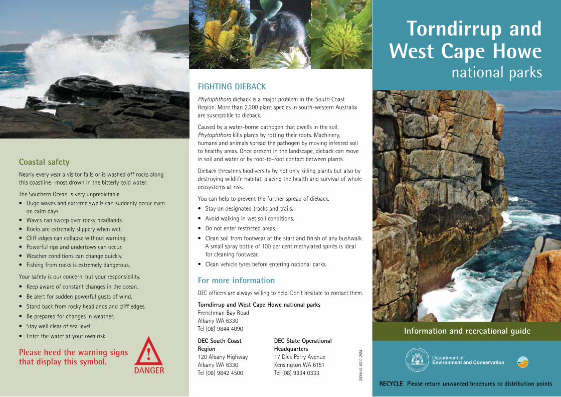
Torndirrup National Park occupies the rugged southern coastline of Torndirrup and Flinders peninsulas where limestone cliffs, granite headlands and white sandy beaches bear the full force of the powerful Southern Ocean. Located 10 kilometres south of Albany, this 3,906-hectare national park is one of the most visited in Western Australia.TRANSCRIPT
2009
448-
0310
-25M
Coastal safetyNearly every year a visitor falls or is washed off rocks along this coastline—most drown in the bitterly cold water.
The Southern Ocean is very unpredictable. • Hugewavesandextremeswellscansuddenlyoccureven
on calm days.• Wavescansweepoverrockyheadlands.• Rocksareextremelyslipperywhenwet.• Cliffedgescancollapsewithoutwarning.• Powerfulripsandundertowscanoccur.• Weatherconditionscanchangequickly.• Fishingfromrocksisextremelydangerous.
Your safety is our concern, but your responsibility.
• Keepawareofconstantchangesintheocean.
• Bealertforsuddenpowerfulgustsofwind.
• Standbackfromrockyheadlandsandcliffedges.
• Bepreparedforchangesinweather.
• Staywellclearofsealevel.
• Enterthewateratyourownrisk.
Please heed the warning signs that display this symbol.
DANGER
!
Changing coastlineThecoastlinesofTorndirrupandWestCapeHowenationalparks display spectacular geological features. This area of the Australian coastline was connected to Antarctica millions of years ago when both continents formed part of the super-continent Gondwana.
Ocean-carvedfeatures,suchasTheGapandNaturalBridgefoundinTorndirrupNationalPark,andtheprominentheadlands in both parks, are the remains of an ancient mountain range.
ThedarklydramaticcapeknownasWestCapeHoweismostly formed of dolerite, a mineral-rich rock that forced its way upwards as molten rock into the older granite of the mountain range. Outcrops of this rock occur for nearly 35 kilometres inland from the cliffs.
The mountain range slowly eroded and its granite core becameexposedandfractured,creatingapatternofverticaland horizontal cracks called joints. Some joints gradually joined together, carving out granite blocks, many of which have been swept away by the powerful Southern Ocean.
InTorndirrupNationalPark,theseawaterthatisexpelledthroughtheBlowholesentersthroughaverticaljointintheunderlyinggranite.TheNaturalBridgeremainsinplacedespite the loss of lower granite blocks to the pounding oceanwaves.TheGapexistswhereaverticalstackofblockswas removed.
Thecoastalrockswillcontinuetofracture.Eventually,theNaturalBridgewillfall.Moregraniteblockswillbeswept away, creating and destroying features like The Gap, constantly reshaping an ever-changing coastline.
TORNDIRRUP NATIONAL PARKThree connected peninsulas, Torndirrup, Vancouver and Flinders,embraceandprotectAlbany’sPrincessRoyalHarbour.
TorndirrupNationalParkoccupiestheruggedsoutherncoastlineofTorndirrupandFlinderspeninsulaswherelimestone cliffs, granite headlands and white sandy beaches bear the full force of the powerful Southern Ocean. Located 10 kilometres south of Albany, this 3,906-hectare national parkisoneofthemostvisitedinWesternAustralia.Allparkroads are suitable for two-wheel drive vehicles.
Thepark’swind-prunedcoastalheathlandsputonacolourful display of wildflowers in spring. Thickets of banksia heath lie inland from the granite headlands, providing a year-roundbanquetforthepark’ssmallestmarsupial,thehoney possum.
AmixedforestofmediumheightkarriandswampyateliessouthoftheknobblyfingerofVancouverPeninsula.Peppermintwoodlandscanbefoundthroughoutthepark.The bush abounds with wildlife, although many species are nocturnal,includingthedunnart,mardoandquenda.
The park provides habitat for many reptile species. It is not unusual to find a carpet snake stretched across a road in the sun.However,poisonoussnakessuchastigersnakesanddugitesarealsofrequentlyseen.Ifasnakeblocksyourroador pathway, it is best to turn around and come back later.
Seabirds and numerous birds of prey can be seen in the sky above the park. Look for a kestrel, black-shouldered kite,whistlingkiteorsquare-tailedkitehoveringnearlymotionlessabovethescrub.Keen-sightedbushwalkerswill see many swift-moving honeyeaters, wrens, red-eared firetails and other birds that live in the heath.
WEST CAPE HOWE NATIONAL PARKJuttingboldlyintotheSouthernOcean,WestCapeHoweisthemostsouthernpromontoryofWesternAustralia.
Thepark’sexceptionallysceniclandscapeincludesdramaticcliffs of granite and black dolerite, isolated golden beaches, rockislands,ruggedlimestoneoutcropsandcomplexpatternsof vegetation including patches of karri forest, peppermint thickets and windswept heathlands.
Nearly 500 species of plants are found in the park including banksias, trigger plants and more than 50 species of orchids. Swampy areas form a habitat for the carnivorous Albany pitcher plant and many bird species.
Fewfacilitiesareprovidedinthiswildareathatliesabout30kilometres west of Albany, yet it attracts campers, bushwalkers, fishermenplusfansofadventureactivities.ShelleyBeachlookout is a prime launching site for hang-gliders.
Two-wheeldrivevehiclescanreachShelleyBeachandthenearbylookout,butothersiteswithintheparkrequirefour-wheeldrive.Parkfeaturescanalsobereachedbybushwalkingalong the sandy four-wheel-drive tracks.
Dolphins, seals and sealions may be spotted from the coastal cliffsofeitherpark.Humpbackandsouthernrightwhalestravel along the coastline during winter and early spring.
Torndirrup and West Cape Howe
national parks
RECYCLE Please return unwanted brochures to distribution points
Information and recreational guide
WEST E R N A U S T R ALIA
TH
E
GO V E R N M ENT OF
FIGHTING DIEBACKPhytophthoradiebackisamajorproblemintheSouthCoastRegion.Morethan2,300plantspeciesinsouth-westernAustraliaare susceptible to dieback.
Causedbyawater-bornepathogenthatdwellsinthesoil,Phytophthora kills plants by rotting their roots. Machinery, humans and animals spread the pathogen by moving infested soil to healthy areas. Once present in the landscape, dieback can move in soil and water or by root-to-root contact between plants.
Dieback threatens biodiversity by not only killing plants but also by destroying wildlife habitat, placing the health and survival of whole ecosystems at risk.
You can help to prevent the further spread of dieback.
• Stayondesignatedtracksandtrails.
• Avoidwalkinginwetsoilconditions.
• Donotenterrestrictedareas.
• Cleansoilfromfootwearatthestartandfinishofanybushwalk.A small spray bottle of 100 per cent methylated spirits is ideal for cleaning footwear.
• Cleanvehicletyresbeforeenteringnationalparks.
For more informationDECofficersarealwayswillingtohelp.Don’thesitatetocontactthem.
Torndirrup and West Cape Howe national parks FrenchmanBayRoadAlbanyWA6330Tel (08) 9844 4090
DEC South Coast Region120AlbanyHighwayAlbanyWA6330Tel (08) 9842 4500
DEC State Operational Headquarters17DickPerryAvenueKensingtonWA6151Tel (08) 9334 0333
NaturalBridge.
WestCapeHowe.
Humpbackwhale. CableBeachandPeakHead.

2009448-0310-25M
Coastal safetyNearly every year a visitor falls or is washed off rocks along this coastline—most drown in the bitterly cold water.
The Southern Ocean is very unpredictable. •Hugewavesandextremeswellscansuddenlyoccureven
on calm days.•Wavescansweepoverrockyheadlands.•Rocksareextremelyslipperywhenwet.•Cliffedgescancollapsewithoutwarning.•Powerfulripsandundertowscanoccur.•Weatherconditionscanchangequickly.•Fishingfromrocksisextremelydangerous.
Your safety is our concern, but your responsibility.
•Keepawareofconstantchangesintheocean.
•Bealertforsuddenpowerfulgustsofwind.
•Standbackfromrockyheadlandsandcliffedges.
•Bepreparedforchangesinweather.
•Staywellclearofsealevel.
•Enterthewateratyourownrisk.
Please heed the warning signs that display this symbol.
DANGER
!
Changing coastlineThecoastlinesofTorndirrupandWestCapeHowenationalparks display spectacular geological features. This area of the Australian coastline was connected to Antarctica millions of years ago when both continents formed part of the super-continent Gondwana.
Ocean-carvedfeatures,suchasTheGapandNaturalBridgefoundinTorndirrupNationalPark,andtheprominentheadlands in both parks, are the remains of an ancient mountain range.
ThedarklydramaticcapeknownasWestCapeHoweismostly formed of dolerite, a mineral-rich rock that forced its way upwards as molten rock into the older granite of the mountain range. Outcrops of this rock occur for nearly 35 kilometres inland from the cliffs.
The mountain range slowly eroded and its granite core becameexposedandfractured,creatingapatternofverticaland horizontal cracks called joints. Some joints gradually joined together, carving out granite blocks, many of which have been swept away by the powerful Southern Ocean.
InTorndirrupNationalPark,theseawaterthatisexpelledthroughtheBlowholesentersthroughaverticaljointintheunderlyinggranite.TheNaturalBridgeremainsinplacedespite the loss of lower granite blocks to the pounding oceanwaves.TheGapexistswhereaverticalstackofblockswas removed.
Thecoastalrockswillcontinuetofracture.Eventually,theNaturalBridgewillfall.Moregraniteblockswillbeswept away, creating and destroying features like The Gap, constantly reshaping an ever-changing coastline.
TORNDIRRUP NATIONAL PARKThree connected peninsulas, Torndirrup, Vancouver and Flinders,embraceandprotectAlbany’sPrincessRoyalHarbour.
TorndirrupNationalParkoccupiestheruggedsoutherncoastlineofTorndirrupandFlinderspeninsulaswherelimestone cliffs, granite headlands and white sandy beaches bear the full force of the powerful Southern Ocean. Located 10 kilometres south of Albany, this 3,906-hectare national parkisoneofthemostvisitedinWesternAustralia.Allparkroads are suitable for two-wheel drive vehicles.
Thepark’swind-prunedcoastalheathlandsputonacolourful display of wildflowers in spring. Thickets of banksia heath lie inland from the granite headlands, providing a year-roundbanquetforthepark’ssmallestmarsupial,thehoney possum.
AmixedforestofmediumheightkarriandswampyateliessouthoftheknobblyfingerofVancouverPeninsula.Peppermintwoodlandscanbefoundthroughoutthepark.The bush abounds with wildlife, although many species are nocturnal,includingthedunnart,mardoandquenda.
The park provides habitat for many reptile species. It is not unusual to find a carpet snake stretched across a road in the sun.However,poisonoussnakessuchastigersnakesanddugitesarealsofrequentlyseen.Ifasnakeblocksyourroador pathway, it is best to turn around and come back later.
Seabirds and numerous birds of prey can be seen in the sky above the park. Look for a kestrel, black-shouldered kite,whistlingkiteorsquare-tailedkitehoveringnearlymotionlessabovethescrub.Keen-sightedbushwalkerswill see many swift-moving honeyeaters, wrens, red-eared firetails and other birds that live in the heath.
WEST CAPE HOWE NATIONAL PARKJuttingboldlyintotheSouthernOcean,WestCapeHoweisthemostsouthernpromontoryofWesternAustralia.
Thepark’sexceptionallysceniclandscapeincludesdramaticcliffs of granite and black dolerite, isolated golden beaches, rockislands,ruggedlimestoneoutcropsandcomplexpatternsof vegetation including patches of karri forest, peppermint thickets and windswept heathlands.
Nearly 500 species of plants are found in the park including banksias, trigger plants and more than 50 species of orchids. Swampy areas form a habitat for the carnivorous Albany pitcher plant and many bird species.
Fewfacilitiesareprovidedinthiswildareathatliesabout30kilometres west of Albany, yet it attracts campers, bushwalkers, fishermenplusfansofadventureactivities.ShelleyBeachlookout is a prime launching site for hang-gliders.
Two-wheeldrivevehiclescanreachShelleyBeachandthenearbylookout,butothersiteswithintheparkrequirefour-wheeldrive.Parkfeaturescanalsobereachedbybushwalkingalong the sandy four-wheel-drive tracks.
Dolphins, seals and sealions may be spotted from the coastal cliffsofeitherpark.Humpbackandsouthernrightwhalestravel along the coastline during winter and early spring.
Torndirrup and West Cape Howe
national parks
RECYCLE Please return unwanted brochures to distribution points
Information and recreational guide
WESTERN AUSTRALIA
TH
E GOVERNMENT O
F
FIGHTING DIEBACKPhytophthoradiebackisamajorproblemintheSouthCoastRegion.Morethan2,300plantspeciesinsouth-westernAustraliaare susceptible to dieback.
Causedbyawater-bornepathogenthatdwellsinthesoil,Phytophthora kills plants by rotting their roots. Machinery, humans and animals spread the pathogen by moving infested soil to healthy areas. Once present in the landscape, dieback can move in soil and water or by root-to-root contact between plants.
Dieback threatens biodiversity by not only killing plants but also by destroying wildlife habitat, placing the health and survival of whole ecosystems at risk.
You can help to prevent the further spread of dieback.
•Stayondesignatedtracksandtrails.
•Avoidwalkinginwetsoilconditions.
•Donotenterrestrictedareas.
•Cleansoilfromfootwearatthestartandfinishofanybushwalk.A small spray bottle of 100 per cent methylated spirits is ideal for cleaning footwear.
•Cleanvehicletyresbeforeenteringnationalparks.
For more informationDECofficersarealwayswillingtohelp.Don’thesitatetocontactthem.
Torndirrup and West Cape Howe national parks FrenchmanBayRoadAlbanyWA6330Tel (08) 9844 4090
DEC South Coast Region120AlbanyHighwayAlbanyWA6330Tel (08) 9842 4500
DEC State Operational Headquarters17DickPerryAvenueKensingtonWA6151Tel (08) 9334 0333
NaturalBridge.
WestCapeHowe.
Humpbackwhale.CableBeachandPeakHead.

TORNDIRRUP NATIONAL PARKBlowholes 50 minutes1.6 kilometres return - including many steps
An impressive sight when there is a high ocean swell, the Blowholesmayormaynotbeblowing.Thislocationoffersviews ofPeakHeadandEclipseIsland.ItisextremelyhazardoustoventuredownslopefromtheBlowholes.
Stony Hill Heritage Trail 20 minutes450 metre circuit - some uneven surfaces
This easy circuit trail leads to one of the highest points in the park from which many features of the southern coastline and interior can be viewed.
Peak Head 2 hours 4.3 kilometres return
Thepeninsula’ssouthernmostpeakcanbereachedviaarugged path that is steep in sections. Some rock scrambling is requiredtoreachthesummit.Beawarethatrockclimbersmaybeon the cliffs below.
Bald Head 6 to 8 hours 12.5 kilometres return - not recommended in gusty or strong winds
A challenging walk, with outstanding views, that leads over IsthmusHilltoFlindersPeninsulaandontoLimestoneHeadandBaldHead.Terrainissteepanddifficultinsections.Donotattempt to return via the beaches due to unseen hazards.
WEST CAPE HOWE NATIONAL PARKFour-wheel-drive vehicle tracks —Bushwalkersarewelcometousefour-wheel-drivetracks.Becautiousoffour-wheel-drivevehicles using tracks. Tracks are very sandy and may cross hills. The rubber matting used to prevent eroding of some tracks is surprisingly slippery when scattered with sand.
Tarbotton Track 30 minutes600 metres return — part boardwalk, part sandy path
The boardwalk section of this easy walk begins at the car parkforShelleyBeachLookout.Wheretheboardwalkends,asandy path continues along a limestone ridge, where it meets theBibbulmunTrackandoffersviewsdownarockyvalleytoShelleyBeachandtheocean.
TarbottonTrackleadingtoShelleyBeach.
Things to doVisitorsofallfitnesslevelscanenjoyTorndirrupNationalPark’sdramaticcoastalscenery.FeaturesincludingTheGap,NaturalBridge,SalmonHoles,JimmyNewellsHarbourandSharpPointcan be seen from viewing platforms located short distances from car parking areas.
Incontrast,muchoftheruggedterrainofWestCapeHoweNationalParkcanbeaccessedonlybybushwalkingor four-wheel-drive vehicle.
BushwalkingIf you intend to walk in remote areas, please inform a responsible personofyourrouteandexpectedtimeofreturn.Takeadequatewaterasnodrinkingwaterisavailableintheparks.Wearsturdyshoesandahat.Bepreparedforpricklyvegetationandsuddenchanges in weather.
Slopingandunevensurfacesexistthroughouttheparks.Granitesurfacescanberoughandslippery.Takeextracarenearrockedges as they can crumble without warning.
Footwearcleaningstationsarelocatedinareaswherethereisahigh risk of spreading the plant pathogen Phytophthora dieback. Pleasethoroughlycleanyourfootwearateachofthesestations.
Bibbulmun TrackThe southern terminus of this 965-kilometre world-class walking track is located in Albany. The track traverses sections of TorndirrupandWestCapeHowenationalparks,offeringscenicvistasofthesoutherncoastline.Formoreinformation,visitaDepartmentofEnvironmentandConservationoffice,alocaltourism visitor centre or www.bibbulmuntrack.org.au.
Symbol signs denote the difficulty of bushwalks.
Protecting habitat and wildlifeNo pets are permitted in national parks, including within cars,parkingareasandonbeaches.Poisonbaits,usedintheparkstokillfoxes,willkilldogs.
Leaverocksandplantsundisturbed.Pleasetakeyourrubbishoutwithyou.Binsarenotprovided.
CampingCampingisnotpermittedatTorndirrupNationalPark.LimitedcampingsitesarelocatedatShelleyBeachinWestCapeHoweNationalPark.Campfiresandcookingfiresarenotallowed.
DivingDunskybeach,atWestCapeHoweNationalPark,isapopularsiteforscuba diving and snorkelling. Strong rip tides sometimes occur in this area. Spear guns and gidgees are not permitted.
FishingFishingispopularatbothTorndirrupandWestCapeHowenationalparks. Normal fishing regulations apply. Species include Australian salmon, shark, groper, mulloway, whiting and herring.
Keepsafetyinmindwhenchoosingafishingsite.Fishingfrom rocksisextremelydangerous.Safetyvestsareavailableforhireorloan from local sporting goods suppliers.
Rock-climbingSitesforproperlyequipped,experiencedclimbersarelocatedin both parks.
Hang-gliding and paraglidingApopularlaunchsiteislocatedatShelleyBeachinWestCape HoweNationalPark.
Two-wheel-drive and four-wheel-drive vehiclesAll vehicles driven in national parks must be licensed for the road. AllroadsinTorndirrupNationalParkaresuitablefortwo-wheel- drive vehicles.
InWestCapeHoweNationalPark,onlyShelleyBeachRoadis suitable for two-wheel-drive vehicles. All other roads and tracks requirehigh-clearancefour-wheeldrive.
ShepherdsLagoonRoadhasveryroughconditionsthatrequire expertdrivingskillsandhigh-clearancevehicles.Accessto BornholmBeachisextremelydifficult.Towingofboggedvehicles isnoteasilyorganisedandisveryexpensive.
Followfour-wheeldrivevehicleguidelinesanddrivetosuit conditions.Watchforbushwalkersusingfour-wheel-drivetracks.
The Gap viewing platform.
ShelleyBeach.