tokyo, japan 11-14 march 2014 discussed by: may khin … bagan (3) radars and (30)awos ... cp and...
TRANSCRIPT

Tokyo, Japan11-14 March 2014
Discussed By:May Khin Chaw, Kyaw Lwin Oo
Department of Meteorology and Hydrology


(37) stations are routinely disseminated every(3) hrly to Global Weather Observing System.(13) More new SYNOP station will transmit on1 April 2014.
Manpower: Out of DMH’s total (1425), we areWorking with (780) Staffs. 55%
64
39
17
o Automatic Weather Station 8

The system was fully operational after Japan’sJICA project on development of Storm forecasting
2010-2012. We are a NC with Tokyo GISC under WIS.

MTSAT (IR) Satellite Image Animation: Cyclone GIRI
“With Cyclone Giri, we have
seen how forecasts and early warning contribute to saving lives.”
“It is crucial that we continue to
strengthen national capacity
and link it to global and
regional systems.”
UN OCHA Remarked DMH
About GIRI Cyclone
• 2006 Apr Cyclone Mala
• 2008 May Cyclone Nargis
• 2010 Oct Cyclone GIRI
• 2011 Oct Tropical Depression

Current Capacity- Community Awareness …
We provide routinely (10) City Specific Forecast to Local FM Radio stations.
If Emergency color, update every (4) to (6) Hours to these Stations.
Some FM Station broadcast Weather News with Local Ethnic Language.
• Higher Authorities take care EW well.• Local Authority and People are high
Awareness for Hazards after 2008.• Supportive Role of INGOs and MNGOs.
Role of StateMedia is Very Important.
Real time updatedInformation on Web for users.
FM Bagan
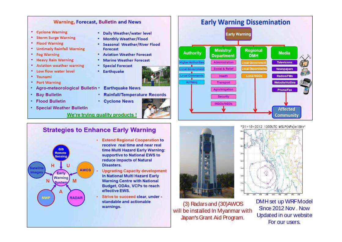
(3) Radars and (30)AWOS will be installed In Myanmar with
Japan’s Grant Aid Program.
DMH set up WRF ModelSince 2012 Nov . Now
Updated in our websiteFor our users.


Parameter Time (UTC) Methods Other
sources
Likelihood of
development of TC
00,12,
Conventional methods ofSynoptic Maps, Upper AirCharts, Pressure Tendency,MTSAT images, SATAIDsoftware are using to analyzeTropical Cyclone.
DeterministicNWP modelsof majorcenters (e.g.ECM WF,NCEP, JMAGSM, SWFDP,UK,JTWC,IMD,CIMSS,RIMES.
Dvorak Intensity (CI, T, DT, PT, MET number)
(3)Hourly
Cyclone Intensity based onDvorak method from RSMC,CIMSS and JTWC are used.

Parameter Time (UTC) Methods Other
sourcesCenter
Position, Accuracy of
center position,
Direction & speed of
movement
(3)Hourly
Center positions are estimated by usingMTSAT satellite images. InformationRSMC, CIMSS and JTWC are mainsources to issue News and Warning.
Central pressure, Maximum sustained
wind speed, maximum gust wind
speed,
(3)Hourly
CP and MSW estimated by using Dvorakmethod and products from RSMC,CIMSS and JTWC are main sources toissue News and Warning.

Parameter
Issu-ance Time (UTC)
Lead time
(hours)Methods
Track 23:3006:3011:30
(24) hour
Track forecasts are mainly based onproducts from RSMC, CIMSS and JTWC aremain sources to issue News and Warning.Hourly weather observations, especiallysurface wind and pressure tendency, fromcoastal stations are used as lowestpressure fall and wind direction.
Central pressure, Maximum
sustained wind,
23:3006:3011:30
(24) hourTrack forecasts are mainly based onproducts from RSMC, CIMSS and JTWC aremain sources to issue News and Warning.

Model Domain(square degree)
Resolution(horizontal & vertical)
Initial Time(UTC)
Forecast Range (hours)
Run by(own/foreign centers)
WRF Model
80°E-101°E6°N-29°N
(30)Km 00 24H,48H,72H Own
JMA Storm surge Model
80°E-101°E6°N-29°N
(30)Km open 24H,48H,72H Own
Diana ModelMet.no
StationTime series
(16)Km 00 72H Met.no

ModelDomain
and resolution
Forecast Range (hours)
Frequency
Considered factors
(Tide/ensemble/ inundation, etc.)
Myanmar Area
15.0N-22.0N90.0E-100.0E
30 kmUp to 48
hours
4 times/day(6 hourly)
Tides: not consider
Inundation: not predicted

Warnings/Advisories and corresponding
emergency responses
DMH issues warnings for disasters/phenomena associated with TCs, such as heavy rain, strong winds and storm surge.
Potential Disaster Risks Landslide, flash flood advise
Target(warning areas)
Expected path of cyclone landfall and inland areas.
Meteorological variables/indices used for criteria/thresholds
for warnings/advisories
Pressure, wind, rainfall, cloud direction from hourly weather observations from coastal stations
Criteria/Thresholds NilContents of
Warning/Advisory Message
Intensity, location, movement, estimated max wind, wind, rainfall, wave, advisory for fisherman and vessels.
Sample Warning/Advisory
Message

• Monsoon Onset and Withdrawal forecast were nearly close to observedMonsoon conditions. 2013 Monsoon accompanied by Cyclone Mahasen.
• Myanmar received above normal Monsoon Season Rainfall.
• Disappearance of Monsoon Break condition triggered heavy rainfalls andrelated secondary hazards during JJAS 2013.
• The cyclone “Mahasen”, which formed over BOB, threatened MyanmarCoasts but effective early warning system with comprehensive andtimely cooperation. 2013 SW Monsoon set in after Cyclone Mahasen.
• Post Monsoon Cyclone ‘Phailin’ ,‘Helen’ and ‘Lehar’ moving towardsIndia Coasts.
• Remnants of Depression from South China Sea were very frequent.
• LP System over BOB and passage of Typhoon remnants from South ChinaSea also lead to late and post monsoon heavy rainfall.
2013 Weather Summary

Recent Activities • Reporting CLIMAT messages to JMA, RA II Focal
starting from Feb 2013.• 10th and 11th Monsoon Forum were organized 3
May and 13 November 2013.• Relocation of GTS/MSS with the support of
WMO.• Provide PWS , public awareness, education and
training program.• Participate regional and international activities
on DRR, CC, PWS, SWFDP, etc.• Initiated Forecast verification and Climate data
application with RClimdex.

Activities with respect to TC Forecasting
• Meteorological Division of Myanmar Department ofMeteorology and Hydrology set up Forecasting groups at NayPyi Taw, Yangon and Yangon International Airport for thePublic Weather Services, aviation weather services.
• All the center produce daily weather forecast, severe weatherforecast and warning including cyclone warning and news.Meteorological Division is lead by Director (Meteorology) withForecasters, Assistant Forecasters, Observers and TVPresenters.
• Recently DMH set up new organization including Radar,Marine Meteorology and Public Relation Section.

Activities with respect to TC Forecasting
• Cyclone news and warning are issued based on different typesatellite images, NWP products, cyclone warning from RSMCand other regional and international institutes, such asCIMSS’s ADT,ODT, JTWC, ECMWF, NOAA, UKMO, JMA, IMDand RIMES.
• Color-coded cyclone warning scheme initiated in 2009Cyclone Bijli. It was very effective during the 2010 CycloneGIRI.
• Other conventional method like Synoptic Charts and UpperWind Charts are also utilized for issuance of cyclone news.RSMC’s Cyclone bulletin, news and warning are received fromGTS and email.
• WMO’s SWFDP products and DMH’s WRF (9)Km/(30)Kmproducts are also utilized.

Activities with respect to TC Forecasting
• Ensemble TC probabilistic forecast from ECMWF, UKMO,Genesis Potential Parameter (GPP) from RSMC, New Delhi,products of SWFDP, TC Formation Alert from JTWC wereutilized.
• Systematic Dvorak Analysis is still need to enhance expertiseof Cyclone Forecasters.
• Various GFS and WRF NWP outputs from many centers werealso used.
• Hourly Surface observations from Coastal areas were veryuseful tools to check cyclone’s approaching, intensity andsend these messages to RSMC CWD via email.
• We prepared phone/fax contact lists of RSMC and neighboringNMHS to contact and share information during emergencytime.

Key Capacity Needs….
• Set up advanced observations instruments/ tools/system.
• Enhance technical capabilities of DMH Staffs/Forecasters/Observers/ICT Engineers.
• Upgrade observations networks for weather, water andclimate activities.
• Improve knowledge on advanced weather, climate, climatechange, radar,NWP.
• Develop international and regional cooperation for sharingtechnical expertises.

Needs and Challenges ….• Observing and monitoring system• Data Processing and Management• Forecasting & Prediction• Warning Generation• Dissemination

Ongoing Project Activities1. The project for establishment of disastrous weather monitoring
system JICA.(3 Radars/30 AWOS/Training )
2. ESCAP-RIMES Project on Strengthening of Myanmar Multi hazardsEarly Warning System June 2013- Nov 2014 with RIMES.(supportcapacity & capability )
3. Strengthening Capacity Development Program with NorwegianMeteorological Institute and ADPC.(Climate Data Application/Rclimdex/ Diana Model/WRF Model Training/PRECIS Model training/JMA Storm surge Model Training)
4. The Project for end-to-end Early Warning System with JICA, Relief andResettlement Department. 2013-2015 (Tidal gauge, effectiveCommunication between TV Broadcasting station and DMH.)


“ We, Myanmar DMH, would like to acknowledge WMO, RA II’s NMHS, JMA,RSMC(New Delhi, Tokyo), Norwegian Met.no, ESCAP, ADPC,RIMES for sharingproducts, outputs, technical transfer to strengthen our capacities andcapabilities. We also Thanks to SWFDP Centers, CIMSS, JTWC and many otherinternational centers for their real time and near real time products andinformation . ”