to: neil g. kornze, acting director, bureau ofland ... · richard hughes re: pueblo ofsanta...
TRANSCRIPT

United States Department of the Interior
OFFICE OF THE SOLICITORWa:-ihingloll. D.C. 20240
" klPI' RIH f( HI
JUN 2 1 2013
M-37028
Memorandum
To: Neil G. Kornze, Acting Director, Bureau of Land ManagementJesse Juen, lew Mexico State Director, Bureau of Land Management
From: Hilary C. Tompkins,SOlicito~~~Subject: Applicability of the New Mexico Bureau of Land Management's Riparian
Policy to Lands within the Boundaries of the Santa Clara Pueblo Grant
I. Issue
The Bureau of Land Management, New Mexico State Office ("BLM"), requested a legalopinion related to the application of its 1989 policy statement concerning the survey ofriparian boundaries of small non-Pueblo holdings ("BLM Riparian Policy" or "Policy",Attachment A) within the exterior boundaries of a Pueblo land grant. The BLM RiparianPolicy provides that where a parcel is bounded by a waterway, such as a lake or river, theparcel is deemed riparian, riparian rights attach, and the associated doctrines of accretion,avulsion, and reliction apply. The BLM Riparian Policy also provides that where theboundary of a parcel is referenced as "a river bank or related component of the river," theparcel so described is also deemed "riparian" such that the boundary can move withsubsequent movements of the waterway. At present, application of the BLM Policy isuniform for all private land claims in New Mexico and does not distinguish privateclaims that are located within the boundaries of a Pueblo land grant.
The Bureau of Indian Affairs, Southwest Region ("BIA"), requested that the BLMconduct a cadastral survey oftwo specific sections of land in the Espanola area of NewMexico ("Chacon property") within the Santa Clara Pueblo (the "Pueblo"). The BLMrequested legal guidance from the Solicitor's Office on the application of its RiparianPolicy to private lands within original Pueblo land grants before finalizing its cadastralsurvey. Our review is limited to the facts presented in this specific matter.
II. Summary Conclusion
The complex factual situations and Federal law principles applicable to the unique historyof Pueblo land grants must be considered before applying the BLM Riparian Policy to

surveys within Pueblo land grants. I The focus of the BLM's Riparian Policy is thecommon law rule that a grant of land bounded by a non-navigable river generally carriesthe exclusive right and title of the grantee to the centerline of the river. In addition, thePolicy extends this common law principle to presume that calls to the bank of the riveralso extend to the centerline. In our view, however, the Pueblo Lands Act of 1924,43Stat. 636 (1924), provides the legal framework within which the BLM must operate whensurveying lands within Pueblo land grants and in that unique context, the Pueblo LandsAct rebuts the presumption applied by the BLM. This advice differs from previousadvice given to the BLM New Mexico by the Southwest Regional Solicitor's Office.That prior advice did not undertake an in depth legal analysis of all applicable law.
The BLM Manual of Surveying Instructions recognizes exceptions to the BLM'sextension of the common law rule. It states that a boundary call to the bank will bepresumed to be to the center of the river, but it goes on to specify at least fourcircumstances where a meander line will be construed as a fixed boundary, rather than asan indicator of the sinuosities of the watercourse. See BLM Manual of SurveyingInstructions, at 3-162 (2009). The exception relevant here is provided in § 3-162(4),which states that a meander line may be considered a fixed boundary "where the factsand circumstances disclose an intention to limit a grant or conveyance to the actualtraverse lines." Id.2 Moreover, where there are federal interests involved, the BLMManual applies federal law to determine boundaries, including instances involving Indianproperty and land grants from foreign nations. See BLM Manual of SurveyingInstructions, at §§ 1-7 (Mexican land grants), 8-3 (Indian lands) & 8-57, 8-58 (Source oflaw). As discussed further below, New Mexico, including grant lands, was acquired bythe United States under the Treaty of Guadalupe Hidalgo. Under Spanish and Mexicanlaw, the sovereign usually retained the bed of any navigable or non-navigable river.Through the Treaty, the land grants came under the control of the United States andMexico's sovereign interest in riverbeds was also transferred to the United States. Then,in confirming the Santa Clara land grant, the United States relinquished all of its title andclaim to lands within the grant, including the riverbed.
Here, the Santa Clara Land Grant encompassed the Rio Grande. The boundarydescriptions for the Chacon land grant located within the Santa Clara Pueblo consistentlyrefer to the bank of the river to describe the physical location of the boundary rather thanto the Rio Grande itself. Further, pursuant to the Pueblo Lands Act, all non-Indiansclaiming land within a Pueblo land grant were required to demonstrate adversepossession, with or without color of title, and payment of taxes before Pueblo title to aparticular parcel of land would be relinquished. See Pueblo Lands Act, Pub. L. No. 68253,43 Stat. 636 (1924). Given the rigorous conditions imposed for relinquishment ofPueblo title, it is reasonable to read a boundary call to the bank of the river as a call to a
I The BLM Manual of Surveying Instructions recognizes that at times a surveyor will encounter complexsituations that raise legal issues that cannot be resolved by the surveyor, but that the surveyor should beaware of these legal issues, use good judgment, and be prepared to provide technical advice. BLM Manualof Surveying Instructions, at § 1-7 (Source of Law) (2009).2 Here the special circumstances are the Pueblo Lands Act and the history of the Santa Clara Pueblo landgrant.
2

physical point or definite location on dry land unless there is evidence to the contrary.This interpretation is also consistent with congressional intent to restore lands to Pueblosthat were lost to non-Indian claimants and extend federal protections against alienation ordiminishment of such lands.
We therefore conclude that the BLM's extension of the common law rule that a grant ofland bounded by a non-navigable river generally conveys title to the centerline of theriver does not apply to the facts here. The boundary description of the Chacon propertyincludes a call to the bank of the river rather than to the river itself and the specialcircumstances of the conveyance at issue indicate a clear federal interest andcongressional intent for the Santa Clara Pueblo to retain title to all lands not expresslyidentified and confirmed as relinquished. Because of this, we conclude that the Pueblolands at issue are subject to federal law and not the riparian common law theory set forthin the BLM Riparian Policy.
III. Factual Background
The BIA requested that the BLM conduct a cadastral resurvey of the Chacon property,located in sections 34 and 35 in Township 21 North; Range 8 East; New MexicoPrincifle Meridian. These lands are within the exterior boundary of the Pueblo of SantaClara. The purpose of the resurvey was to clarify which lands are Pueblo lands andwhich are private lands, based on the adjudications resulting from the Pueblo Lands Act.The BLM completed the resurvey for these sections in accordance with the BLMRiparian Policy whereby the private landowner's boundary would be ambulatory basedon the movement of the Rio Grande, but agreed to delay issuing the resurvey untilreceiving legal advice regarding application of its policy.
The BLM Riparian Policy states, in part, that "two major conclusions are reached andwill be considered policy for this [BLM State] office:
3 These two sections of land are predominantly owned by private landowners who are not members of theSanta Clara Pueblo. Private landowners obtained title pursuant to the adjudications required by the PuebloLands Act. However, over the last 40 years, as the seasonal high flows of the Rio Grande have reduced dueto man-made and natural causes, the banks of the river have moved toward the area that was formerlyriverbed, resulting in "new" dry lands being created adjacent to the river. These two sections contain landsthat run along the Rio Grande, near Espaftola, that are being contested by Pueblo and non-Pueblo landowners.
The question ofownership of these lands was raised before the Interior Board of Indian Appeals ("IBIA")in 2002 after the BIA Regional Director issued a decision determining that certain land along the riverclaimed by the Pueblo of Santa Clara was owned by the Chacon family. The Pueblo appealed to the IBIA,which dismissed the appeal on the jurisdictional ground that the BIA Regional Director lacked the authorityto issue a decision purporting to determine title to land. Pueblo ofSanta Clara v. Acting SouthwestRegional Director, Bureau ofIndian Affairs, 40 IBIA 251 (2005). The IBIA held that because the BIA hadno authority to issue the relevant decision, there was no valid appeal before the Board. The Board notedthat this situation could be resolved either by issuing a Solicitor's Opinion as to title, so long as the partiesagreed to abide by it, or a resurvey completed by the BLM. Id:. n.l O. To date, neither the IBIA nor theInterior Board of Land Appeals ("IBLA") have ruled on the merits of any of the affected New Mexicoprivate landowners' claims to ownership associated with a call to the bank as a defined boundary.
3

1) All claims with boundary calls in the original field notes to a riverbank or a related component of the river, e.g., gravel bars, water, orbed, will be considered riparian.
2) With no river related calls, even though the claim was originallylocated in the vicinity of a river and a portion of the boundaryapproximately traversed the water's edge, the claim boundary isconsidered fixed. Later erosion of the claim by river movementwill not create riparian rights in the formerly upland claim otherthan allowing future accretions to restore the original area of theclaim."
BLM Riparian Policy, Part III. Riparian Nature of Claims, at 2, Attachment A.
The BLM Riparian Policy also cites the common law rule that "government conveyanceof title to a fractional subdivision fronting upon a non-navigable stream, unless specificreservations are indicated, either in the patent from the federal government or in the lawsof the state [sict in which the land is located, carries ownership to the middle of thestream." Id. (citation omitted) (emphasis in original). The policy concludes by declaring:
When parcels of land meet Part III-I, described above, Cadastral Surveyrecognizes riparian ownership to the medial line. When parcels of landmeet Part 111-2, described above, the upland owner would not enjoyriparian rights.
BLM Riparian Policy at 3. This statement is of special importance because it means, ineffect, that the BLM adopted its own variation of the common law rule that nowpresumes any reference to a river bank or a river-related feature in a survey description asriparian and ownership of the riverbed will be conveyed to the medial line of the streamor ''the center line of the water at the time the boundary was first established." Id. at 2.Accordingly, when a waterway that is the boundary of land moves through an accretiveor relictive event, the boundary line also moves. Thus, if the BLM Riparian Policy isapplied to the parcels of land within the Santa Clara Pueblo, the boundary of the nonIndian land parcels within the Pueblo's land grant would move with such events and anynewly accreted or relicted dry lands would be owned by the private land owner ratherthan by the Pueblo.s
The Pueblo has disputed this application of the BLM Riparian Policy and argues that titleto the bed of the Rio Grande was never relinquished by the Pueblo. See Letter from
4 Here, the phrase "or the laws of the state" is inapplicable because a federal statute controls and a statecannot mandate what the federal government conveys or does not convey. BLM Manual of SurveyInstructions § 8-57(1).5 A factual determination has not been made as to whether there has been an event that could becharacterized as accretion, reliction, or avulsion of the Rio Grande. Reliction, unlike accretion andavulsion, does not necessarily involve movement of the river from one side of its banks to another ordisplacement of the course of the river. Rather, in reliction the river draws down to a center channel eitherexposing previously submerged lands through natural events or by damming, channelizing, or other manmade methods. BLM Manual of Survey Instructions § 8-84.
4

Richard Hughes Re: Pueblo of Santa Clara/Charlie Chacon Claim (Jan. 28,2011). ThePueblo claims ownership ofall lands, including the bed of the Rio Grande, that lie withinthe bounds of the grant made by Spain, confirmed by Congress, and recognized by thePueblo Lands Board for which Pueblo title was not expressly extinguished. Further, thePueblo argues that neither the Pueblo nor the United States authorized the relinquishmentof title to lands beyond those for which adverse possession had been demonstratedpursuant to the Pueblo Lands Act and as defined in title documents and limited by themetes and bounds descriptions in survey field notes. Id.
Conversely, private landowners, who trace their chain of title to the private claimantsreceiving confirmation of lands through the Pueblo Lands Board, also claim title to thelands physically surveyed and demarcated and to any additional dry land that becameavailable for use through accretion or reliction. See, e.g., Order Vacating Decision,Pueblo ofSanta Clara v. Acting Regional Director, Bureau of Indian Affairs, 40 IBIA251,251-52 (Feb. 16,2005). The private landowners' claim is based on the belief thatthe title granted by the Pueblo Lands Board also conferred the riparian rights of accretionor reliction consistent with the BLM Riparian Policy as presently written.
IV. Legal Background
Federal and state courts have addressed the complex questions associated withdetermining title to property bounded by waterways on both private and public lands, aswell as to lands held in trust for individual Indians and federally recognized tribes. Thesecases have not, however, dealt with the application of these questions to private landholdings within Pueblo grant boundaries. In assessing the legal sufficiency of the BLMRiparian Policy as applied to the facts presented to us, we begin by reviewing federal andstate common law principles and doctrines applied to riparian lands in general. We thenreview the unique legal history of Pueblo land title and the provisions governingrelinquishment of title to non-Indian claimants.
A. Federal Law and Riparian Lands
Under federal law applicable to public lands,6 unless a contrary intention is stated or maybe inferred from the terms of the grant, a federal grant of public land bounded by a nonnavigable stream or river conveys ownership to the center or thread of the water.7
Where the United States owns the bed of a nonnavigable stream and theupland on one or both sides, it, of course, is free when disposing of theupland to retain all or any part of the river bed; and whether in anyparticular instance it has done so is essentially a question ofwhat itintended. If by a treaty or statute or the terms of its patent it has shown
643 U.S.C. § 931 ("in all cases where the opposite banks of any streams not navigable belong to differentpersons, the stream and the bed thereof shall become common to both."). Notably, this law does not applyto Indian trust lands.7 Questions of navigability are federal questions. See United States v. Utah, 283 U.S. 64, 75 (1931); UnitedStates v. Oregon, 295 U.S. 1, 14 (1935).
5

that it intended to restrict the conveyance to the upland or to that and apart only of the river bed, that intention will be controlling; and, ifitsintention be not otherwise shown, it will be taken to have assented that itsconveyance should be construed and given effect in this particularaccording to the law of the State in which the land lies. Where it isdisposing of tribal land of Indians under its guardianship the same rulesapply.
Oklahoma v. Texas, 258 U.S. 574, 594-95 (1922). Thus, federal law generally controls ininterpreting the boundaries of grants by the United States, but in some instances wheregrants are made without reservation or restriction, courts have construed them accordingto the law of the state in which the land lies. See, e.g., United States v. ChamplinRefining Co., 156 F.2d 769, 773 (10th Cir. 1946), aff'd331 U.S. 788 (1947); Bear v.United States, 611 F. Supp. 589, 594 (D. Neb. 1985) (holding that title to accreted lands,unless preserved, including land within Indian reservations, passes with any conveyanceof appurtenant land) (emphasis added).
With respect to state law, most states apply the common law rule that when a nonnavigable8 waterway forms a boundary between two parcels of land, and that waterwaymoves by processes of accretion or erosion, the boundary between the parcels of landfollows the movements of the river. Wilson v. Omaha Indian Tribe, 442 U.S. 653, 660(1979) (citing United States v. Wilson, 433 F. Supp. 57,62 (N.D. Iowa 1977)). The BLMRiparian Policy adopts this general principle. The common law rule also provides thatthis presumption applies unless the terms of the grant and the attendant circumstancesdenote an intention to stop at the edge or margin of the river. Choctaw and ChickasawNations v. Seay, 235 F.2d 30,35 (10th Cir. 1956), cert. denied 352 U.S. 917 (1956)(emphasis added). See also BLM Manual of Surveying Instructions, at § 3-162(4). Thelegal effect of accretion with regard to riparian boundaries is such that when a nonnavigable river moves by accretion, the boundary line set by the river continues to runthrough the center of the river channel in its new location including the accumulatedsoi1.9 Nebraska v. Iowa, 143 U.S. 359,360-61 (1982) (citations omitted).
The common law rule for riparian lands has been found to apply in instances "where theUnited States disposes of tribal lands of Indians under its guardianship." Choctaw andChickasaw Nations, 235 F.2d at 35; see also Oklahoma v. Texas, 258 U.S. 574, 594-95(1921) ("Where [the United States] is disposing of tribal land of Indians under itsguardianship the same rules apply" as to any other disposition of land). In othercircumstances, however, federal law is held to be controlling. Notably, the Supreme
8 For purposes of this memorandum, the Rio Grande constitutes a non-navigable river. See United States v.Rio Grande Dam & Irrigation Co., 174 U.S. 690, 696 (1899).9 For a riparian parcel, the act of accretion "denotes the process by which the area ofowned land isincreased by the gradual deposit of soil due to the action of a bounding river or other body of water."Bauman v. Choctaw-Chickasaw Nations, 333 F.2d 785, 789 (10th Cir. 1964). Conversely, awlsion isdistinguished by "the more rapid, easily perceived and sometimes violent, shifts of land incident to floods,storms or channel breakthroughs ...." Bauman, 333 F.2d at 789. Awlsive events do "not affect title tothe lands thus transferred from one side of the river to the other." ld; see also Nebraska v. Iowa, 143 U.S.359,361 (1892).
6

Court in Wilson, 442 U.S. at 671, found that federal law controlled the issue of Indianproperty rights where "the United States has never yielded title or terminated its interest"over the Indian trust lands, although state standards could be borrowed whereappropriate. Similarly, the BLM Manual of Surveying Instructions discusses source oflaw considerations where there is a Federal interest. For example, where the "boundariesof Indian property are to be determined," federal law is applied, and federal law is used todetermine the ownership ofbeds and banks of waterways where there is a federal interest.See BLM Manual of Surveying Instructions §§ 8-3 (Indian lands), 8-57, 8-58 (Source ofLaw Considerations). Moreover, according to the BLM Manual of SurveyingInstructions, "boundaries created by foreign sovereigns, such as Mexican land grants, willbe controlled by application of the relevant law of Mexico at the time the boundary wasestablished." BLM Manual of Surveying Instructions, at § 1-7. As discussed below,New Mexico was acquired by the United States from Spain pursuant to the Treaty ofGuadalupe Hidalgo. Under Spanish and Mexican law, the sovereign retained the bed ofany navigable or non-navigable river. 10 With respect to the Pueblo land grants in NewMexico, those lands were not at any time "public lands" subject to general disposal by theUnited States. Rather, they were communal fee lands granted by the Spanish crown tothe Pueblos, title to which the United States was required to recognize and respect underthe Treaty of Guadalupe Hidalgo. And, as explained below, in reviewing and confirmingthe Pueblo's land grant, the United States relinquished all title and claim that it couldassert to lands within the grant and expressly included the riverbed in the acreageconfirmed. 11
B. The History of Pueblo Land Title and the Pueblo Lands Act of 1924
In reviewing the treaties, statutes and law surrounding the history of the Pueblos, it isimportant to note that the canons of construction that derive from the unique relationshipbetween the United States and Indian tribes apply to any ambiguities in a statute. See,e.g., Choate v. Trapp, 224 U.S. 665 (1912). Under these canons, statutory silence orambiguity is not to be interpreted to the detriment of Indians. Instead, statutesestablishing Indian rights and privileges are to be construed liberally in favor of theIndians, with any ambiguities to be resolved in their favor. Minnesota v. Mille Lacs BandofChippewa Indians, 526 U.S. 172,200 (1999); see also County ofYakima v.Confederated Tribes and Bands ofthe Yakima Indian Nation, 502 U.S. 251, 269 (1992).
Indeed, the legal history of Pueblo lands is unique among Indian tribes in the UnitedStates. The Pueblo Indians lived in organized communities well before the earliestSpanish explorers visited the region and, in many cases, the Indians were occupying thesame lands they now occupy. See Mountain States Tel. & Tel. Co. v. Pueblo ofSantaAna, 472 U.S. 237,240 (1985). "From the earliest days, the Spanish conquerorsrecognized the Pueblos' rights in the lands they still occupy, and their ownership of theselands was confirmed in land grants from the King of Spain" and later by the independentGovernment of Mexico. Id. The United States took possession ofpresent-day New
10 See Pardita 3, Title 28 Laws 26, 31.II See infra discussion at pp. 8-11.
7

Mexico during the war with Mexico, which ended with the ratification of the Treaty ofGuadalupe Hidalgo in 1848.
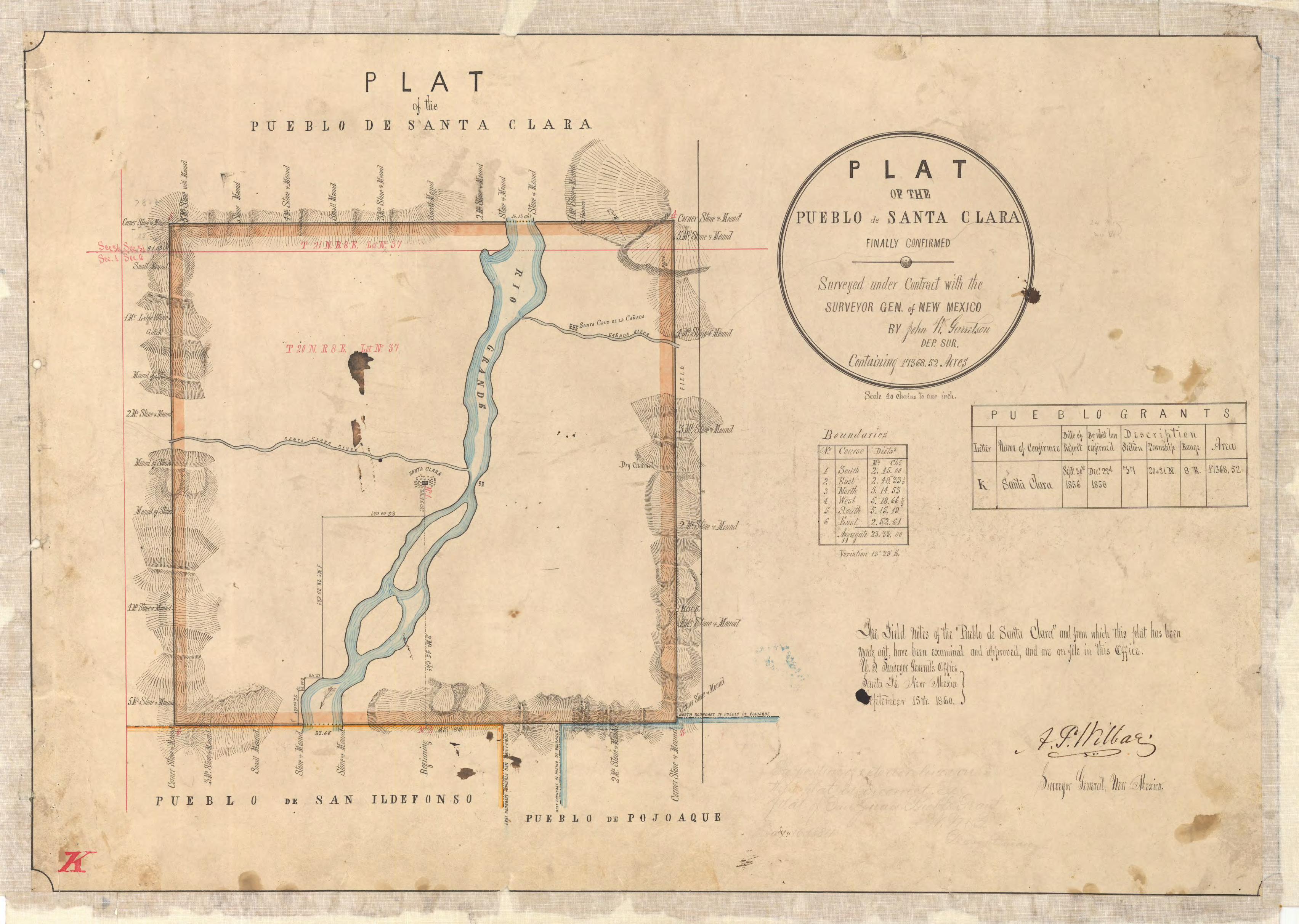
Early confusion regarding whether the Pueblos were Indian tribes and entitled toprotection under federal law led to Pueblo land being lost and transferred to non-Indians.In 1851, three years after the Treaty of Guadalupe Hidalgo, Congress extended the IndianTrade and Intercourse Act to "Indian tribes of the territories ofNew Mexico and Utah."Act of Feb. 27, 1851, ch. 14, § 7, 9 Stat. 574. And, on September 30, 1856, the SurveyorGeneral ofNew Mexico recommended that Congress confirm Santa Clara's Spanish landgrant in his report to the Department of the Interior pursuant to Section 8 of the Act ofJuly 22, 1854 (10 Stat. 308) ("The Pueblo Indians are constantly encroached upon ...[and] despoiled of their best lands; I therefore respectfully recommend that these claimsbe confirmed by Congress as speedily as possible ...."). Report of the Commissioner ofthe General Land Office, Annual Report of the Surveyor General ofNew Mexico, at225 (Sept. 30, 1856).12 Based on the report of the Surveyor-General ofNew Mexico, theSanta Clara Pueblo land title, which had been recognized by the Spanish and MexicanGovernments, was confirmed by Congress in the Act of December 22, 1858 (11 Stat.374).13 In recognizing the Santa Clara land grant, the United States also expresslyrelinquished "all title and claim of the United States to any of said lands ...." Id. OnSeptember 15, 1860, the Surveyor-General ofNew Mexico approved the final plat of thesurvey of the Pueblo of Santa Clara. The final plat of the Santa Clara Pueblo from 1860showed the total acreage as including the Rio Grande and it is this total acreage that wasrecognized by Congress as belonging to the Pueblo of Santa Clara. 14 See Attachment B.
Notwithstanding Congress' extension of the Indian Trade and Intercourse Act andsubsequent confirmations of land grants to the Pueblos, in the late 1800s, the NewMexico Territorial Supreme Court in United States v. Lucero, 1 N.M. 422 (N.M. Terr.1869), and later the United States Supreme Court in United States v. Joseph, 94 U.S. 614(1876), ruled that the Pueblos were not Indian tribes within the meaning of the IndianTrade and Intercourse Act. Several years later Congress, in the New Mexico EnablingAct, provided that "all lands owned or held by any Indian or Indian tribes acquiredthrough or from the United States or any prior sovereignty shall be and remain subject tothe disposition and under the absolute jurisdiction and control of the Congress." Act ofJune 20,1910, ch. 310,36 Stat. 557.15 Then in United States v. Sandoval, 231 U.S. 28,
12 The 1854 Act established the office of the Surveyor-General in certain states, including New Mexico,and Section 8 directed the Surveyor-General to ascertain the extent and locality ofall Pueblo claims so thata report could be submitted to Congress to take "such action thereon as may be deemed just and proper,with a view to confirm bona fide grants, and give full effect to the treaty of [Guadalupe Hidalgo]." 10 Stat.309 (emphasis added).13 The 1858 congressional recognition of Pueblo land title provided that ''this confmnation shall only beconstrued as a relinquishment ofall title and claim of the United States to any of said lands, and shall notaffect any adverse valid rights, should such exist." II Stat. 374.14 A previous plat from July 26, 1859 included the Rio Grande within the exterior boundary of the Puebloand noted the total acreage of the Pueblo-both with and without the land covered by the Rio Grande.IS The Enabling Act further specified that ''the terms 'Indian' and 'Indian country' shall include the PuebloIndians ofNew Mexico and the lands now owned or occupied by them." 36 Stat. 560. The New MexicoConstitution provided a similar guarantee to Pueblo land tenure:
8

47 (1913), and in United States v. Candelaria, 271 U.S. 432, 441 (1926), the SupremeCourt made clear that the Pueblos were indeed Indians tribes, subject to the plenaryauthority of Congress and the exercise of its guardianship over Indians. By this time, as aresult of the Lucero and Joseph decisions, non-Indians had already acquired Pueblo landholdings through sale, adverse possession, delinquent taxes, and other methods. SeeMountain States, 472 U.S. at 243. The Supreme Court's decision in Sandoval, however,cast doubt over the validity of title to lands held by non-Indians within a Pueblo landgrant. See, e.g., id.
To address these increasing issues of title and ownership of disputed Pueblo lands,Congress enacted the Pueblo Lands Act in 1924. Pueblo Lands Act of 1924, ch. 331, 43Stat. 636. The primary purpose of the Pueblo Lands Act was to consolidate title in thePueblos by settling and adjusting conflicting land claims by non-Indians and "secur[ing]for the Indians all of the lands to which they are equitably entitled." S. Rep. No. 492,68th Cong., 1st Sess., at 5 (1924). This objective was accomplished in large part by theUnited States bringing quiet title suits against non-Indian claimants. Pueblo Lands Act§ 1. The Pueblo Lands Act also established a Pueblo Lands Board, composed of theAttorney General, the Secretary of the Interior (each ofwhom was authorized to actthrough an assistant), and a third member appointed by the President. The Pueblo LandsBoard examined all non-Indian property claims within the exterior boundaries of thePueblo land grants. The Board issued a report for each Pueblo describing "any landgranted or confirmed to the Pueblo Indians ofNew Mexico ... title to which the saidboard shall fmd not to have been extinguished in accordance with the provisions of thisAct ...." Id § 2.
The Pueblo Lands Act allowed for the continued occupation of discrete parcels of land bynon-Indians who could meet the strict criteria for establishing a valid claim under Section4 of the Act. Section 4 provided that non-Indians could assert a claim by (a)demonstrating actual adverse possession of the claimed lands under color of title fromJanuary 6, 1902 to the date ofpassage of the Pueblo Lands Act, and payment of all taxesdue during that period; or (b) adverse possession from 1889 to 1924 and payment of alltaxes due since 1899. Id § 4. In this way, the Pueblo Lands Board administrativelyinvestigated and determined the validity ofprivate land claims. Based upon the Board'sreport, the Attorney General then brought actions to quiet title in federal district court toresolve claims for which the Pueblo Lands Board found no extinguishment of Pueblotitle. Parties who could satisfy the Section 4 requirements were able to prove up theirprivate land claims in the district court. Through this process, private land claims withinthe Pueblo land grants were adjudicated, and, if successful, resulted in specificidentification ofboundaries for those lands. The successful claimant received a patent in
The people inhabiting this state do agree and declare that they forever disclaim all right and title ...to all lands lying within said boundaries owned or held by any Indian or Indian tribes, the right ortitle to which shall have been acquired through the United States, or any prior sovereignty; and thatuntil the title of such Indian or Indian tribes shall have been extinguished the same shall be andremain subject to the disposition and under the absolute jurisdiction and control of the congress ofthe United States.
N.M. Const., Art. XXI, § 2 (adopted Jan. 21, 1911).
9

which the United States and the Santa Clara Pueblo relinquished all claims to thatspecific parcel of land.
Thus, by enacting the Pueblo Lands Act, Congress intended to permanently settle titledisputes to non-Indian lands with finality, confirm Pueblo land holdings, and protectPueblo lands from future diminishment and alienation. See United States v. Thompson,941 F.2d 1074, 1078 (10th Cir. 1991); see also S. Rep. No. 492 at 11. 16 Pursuant toSection 13 of the Pueblo Lands Act, after concluding that a non-Indian land owner hadcarried his burden under Section 4, a survey of the Pueblo and non-Indian lands wasconducted. The survey notes and plats were then made a part of the patent issued to thenon-Indian. See Pueblo Lands Act § 13. The survey documents contained metes andbounds descriptions for particular parcels of land and specific acreages for each parcel.Section 13 of the Act also provided that these field notes and plats, certified by thesurveyor general ofNew Mexico, were to be accepted as "competent and conclusiveevidence of the extinguishment of all the right, title, and interest of the Indians in and tothe lands so described . ..." Id (emphasis added).
Separate and apart from the intent of Congress in enacting the Pueblo Lands Act and theprocedures it created in order to settle land title, the Pueblo Lands Act also grantedprotections to the Pueblo lands that had not been affirmatively stated in prior legislation.Specifically, Section 17 of the Pueblo Lands Act requires that future land transfers besubject to federal and not state law, and protects Pueblo lands against alienation withoutconsent of the Secretary of the Interior. Pueblo Lands Act § 17; Alonzo v. United States,249 F.2d 189 (10th Cir. 1957). See also Mountain States, 472 U.S. at 240. The court inAlonzo recognized that Section 17 of the Pueblo Lands Act, by placing restrictions onalienation of Pueblo lands, "insured that the restrictions implicit in the decision in UnitedStates v. Sandoval, would continue in force as to lands, title to which was found to be inthe Pueblos." Alonzo, 249 F.2d at 195 (citation omitted). The court further held that"[t]he power of Congress to reimpose restrictions [on alienation of Pueblo lands] whilethe Pueblos were still wards of the Nation is not open to question." Id. at 196 (quotingBrader v. James, 246 U.S. 88,96 (1918)); McCurdy v. United States, 246 U.S. 263,273(1918). Indeed, the court concluded that "[w]e are of the opinion that the restrictionsagainst alienation apply to lands acquired by the Pueblo through purchase, as well as tolands acquired by the Pueblo in any other manner." Id.
The patents issued by the Pueblo Lands Board contained specific metes and boundsdescriptions and specific acreages, title to which was thereby extinguished in the
16 The Pueblo Lands Act also provided for consolidation of each Pueblo's land holdings throughidentification ofparcels within and adjacent to the exterior boundaries of the Pueblo that could bepurchased from non-Indians for transfer to the Pueblo. Pueblo Lands Act § 8. In a 1929 legal opinionconcerning the quality of title of the lands to be purchased and restored to the Pueblos, Solicitor E.C.Finney observed that ''the tracts to be purchased were originally held by the Indians in communal feesimple ownership and are surrounded by other lands held by the Indians under the same sort of title."Claims within Indian Pueblos-New Mexico, Dept. of the Interior Solicitor's Opinion, M-25278, August 7,1929, (1 Opinions of the Solicitor Related to Indian Affairs 222, 225). Finney concluded that ''the intention[of Congress] was to remove these non-Indian claimants by purchase of their rights and restore the lands totheir original status." [d.
10

Pueblo. 17 The Tenth Circuit has recognized that when patents to land from the UnitedStates are designated by a phrase referring to the plats made from the surveys, the officialplat becomes part of the instrument of conveyance. Walton v. United States, 415 F.2d121, 123 (10th Cir. 1969). The Walton court further held that "[t]he importance ofpatents as the highest evidence of title is well settled." Id. (quoting United States v.Stone, 69 U.S. 525 (1864)). It is also well settled law in the Tenth Circuit that "[i]n apublic grant nothing passes by implication and, unless the grant is clear and explicitregarding the property conveyed. a construction will be adopted which favors thesovereign rather than the grantee." Id. (emphasis added) (citing McDonald v. UnitedStates, 119 F.2d 821 (9th Cir. 1941)), cert. granted, Great Northern Ry. Co. v. UnitedStates, 314 U.S. 596, modified, 315 U.S. 262 (1942)). Additionally, Section 13 of thePueblo Lands Act provided that these certified plats and field notes "shall be accepted inany court as competent and conclusive evidence of the extinguishment of all the right,title, and interest of the Indians in and to the lands so described in said plat and fieldnotes and of any claim of the United States in or to the same." Pueblo Lands Act § 13.Thus, based on the purpose of the Pueblo Lands Act to permanently settle title disputesand consolidate Pueblo land holdings and the description of the final plat issued to thePueblo and the patents issued to non-Indians pursuant thereto, the conveyances of thenon-Indian lands are limited and fixed by the metes and bounds descriptions, and are notambulatory based on the movement of the river. See Bauman, 333 F.2d at 788 ("Underthe common law ... a grantor who owns to the center or thread of the stream ... conveysto the center of the stream, unless the terms of the grant and the attendant circumstancesclearly denote an intention to stop at the edge ... of the river.") (emphasis added)).
C. A Call to the Bank and New Mexico Law
Even when looking to state law to address the question presented here, the New Mexicocourts provide little to no guidance. There are some New Mexico Supreme Court casesadopting the common law rule that "where a natural object having extension is named asa boundary, the line runs to the middle of the object. This interpretation has beenrepeatedly held as to non-navigable rivers and lakes ...." Tagliaferri v. Caesar Grande,120 P. 730, 731 (N.M. 1911); see also Burnham v. City ofFarmington, 957 P.2d 1163,1168 (N.M. Ct. App. 1998). However, a review ofthe reported New Mexico state casesreveals no authority addressing the question of whether a surveyor's use of the "bank" asa boundary demonstrates an intention to extend the boundary to the centerline of thewaterway. In many states, however, courts have taken the position that a call to the bankrepresents a fixed point rather than the middle of the water course. 18 New Mexico courts
17 The patent or certificate of title issued to the successful non-Indian claimant "shall have the effect only ofa relinquishment" of title by the United States and the Pueblo. Pueblo Lands Act § 13.18 E.g., Glover v. Giraldo, 824 P.2d 552, 554 (Wyo. 1992) (a boundary definition of the "bank"demonstrates an intention by the grantor to retain ownership of lands below the bank); Comm'rsCommercial Waterway Dist. No.2 o/King County v. Seattle Factory Sites Co., 135 P. 1042, 1047 (Wash.1913) ("where the description is specific in its language, naming the bank of the stream as the boundary ofthe land conveyed, we think the decided weight of authority is to the effect that the grantee's rights will notextend beyond such specified boundary so as to give him any right in the bed of the stream."); Murphy v.Copeland, 51 Iowa 515 (1879); Jenkins v. Cooper, 50 Ala. 419 (1874); People ex rei. Burnham v. Jones,112 N.Y. 597 (1889); People ex rei. Comm'rs a/Highways v. Board o/Sup'rs o/Madison County, 125 Ill. 9
11

have also not addressed this issue with regard to private land holdings within Puebloboundaries.
D. Previous Legal Memoranda Addressing the BLM Riparian Policy
The Southwest Regional Solicitor's Office has, on two prior occasions, provided legalmemoranda regarding Pueblo lands and the BLM Riparian Policy. First, in 1998, theSouthwest Regional Solicitor, Tim Vollmann, authored an opinion responding to arequest from BIA regarding a trespass on San Juan Pueblo. "Riparian Trespass Issue atSan Juan Pueblo," Tim Vollmann, Feb. 27, 1998 ("Vollmann Opinion"). In his opinion,Vollmann addressed whether a tract of land along the Rio Chama, where the patentdesignated the eastern boundary as the right bank of the river, created riparian rights toaccreted land as the river moved to the east. Vollmann cited the common law rule that aboundary defined by a non-navigable river includes the riparian right of accretion basedon subsequent movement of the river. Vollmann Opinion at 1-2. Vollmann noted that''these laws governing riparian ownership are not merely applicable to public lands, but toall forms of riparian ownership." Id. at 2. Referring to Wilson v. Omaha Indian Tribe,442 U.S. 655, discussed above, Vollmann also reached the overly broad conclusion thatthe common law rule governing riparian ownership had been applied successfully toIndian claims. Id. As noted supra, in Wilson, the court held that federal law governedthe substantive aspects of the case, although state law standards could be borrowed whereappropriate. Id. at 672-73.
In reaching his conclusion, Vollmann noted that the Taos Pueblo benefitted from theriparian aspect of a similar patent in a case against the Forest Service, Pueblo ofTaos v.Andrus, 475 F. Supp. 359 (D.D.C. 1979). Our review ofAndrus, however, reveals thatthe case is not analogous to the facts and issues presented by the BLM Riparian Policyhere or to the facts at issue in the Vollmann Opinion. The dispute in Andrus involvedinterpretation of measurements provided by competing surveys of a land grant, theeastern boundary of which was defined in a court decree and subsequent surveyinstructions as ''the current of (the) Rio Lucero to its source." Id. at 362. The initialsurvey was found to have improperly located the meander lines for the Rio Lucero atsome distance from the actual location of the river. In resolving the matter, the courtnoted the general rule that "where a surveyor intended to meander the contours of a bodyofwater forming the boundary of a tract of land, the true boundary is the body of waterand not the meander lines." Id. at 366. The court also noted that the case did notconstitute a quiet title action because title to both parcels of land at issue were held by theUnited States, one parcel held in trust for the Pueblo of Taos and the other under themanagement ofthe Forest Service. Id. at 365. The court therefore determined that suchan adjustment did not affect an actual ownership interest. Id.
(1888); 1 Gould, Waters (3d ed.), § 199), compare with, Del/ana v. Walker, 866 S.W. 2d 355,359 (Tx.App. 1993) (description with meander line creates the stream as the boundary and accretion applies);Sheldon v. Sevigny, 272 A.2d 134, 137 (N.H. 1970) (the fact that a deed boundary runs "by the bank" ofariver does not denote an intent to limit the conveyance away from the water' s edge); Wilt v. Endicott, 684P.2d 595, 600 (Or. Ct. App. 1984) (absent additional evidence, a boundary defined as the "bank" willinclude riparian rights of accretion).
12

Importantly, however, Vollmann's opinion does not address or discuss the purpose andintent of the Pueblo Lands Act in resolving non-Indian claims within the Pueblos'boundaries. And, by analogizing to a case where the boundary call at issue was to theriver and not to the bank, the Vollmann Opinion did not distinguish between the factualdifferences presented in the San Juan Pueblo case and those described in Andrus. 19 Thus,in applying the common law rule, his opinion fails to examine whether the calls to thebank in the survey field notes or the circumstances of the conveyance taken as a wholeindicate an intent to limit the conveyance to the bank of the river. Although Vollmann'sopinion appears to apply the common law rule to Pueblo lands, he qualifies his opinionby stating that he would like to know if the Pueblo's legal counsel has other legal theoriesthat could be utilized to assert a claim to the riparian lands on the Pueblo's behalf. Id. at3.
On March 1, 2002, Acting Southwest Regional Solicitor Grant Vaughn issued amemorandum to the BIA regarding the same boundary considerations involving Mr.Chacon within the Santa Clara Pueblo that are at issue here. In a cursory one-pagememorandum, Vaughn concluded that, based on the materials provided by the BIA, theboundary defined by the bank of the Rio Grande included the riparian right of accretion.The memorandum does not reference federal or state statutes or case law. The BIA thenissued its decision and the Pueblo appealed to the IBIA, which dismissed the appeal onthe jurisdictional ground that the BIA Regional Director lacked the authority to issue adecision purporting to determine title to land. Pueblo ofSanta Clara v. Acting SouthwestRegional Director, Bureau ofIndian Affairs, 40 IBIA 251 (2005).20
To the extent that the 1998 Vollmann Opinion and the 2002 Acting Regional Solicitoropinion conflict with the present legal opinion, those earlier opinions are herebysuperseded.
IV. Legal Analysis
A. Federal Law Controls Intemretation of Pueblo Land Title
In 1858, Congress confirmed title to the Santa Clara Pueblo land grant, which had beenrecognized by the Spanish and Mexican Governments. Pursuant to this action, theSurveyor-General ordered a survey of the Pueblo boundaries. The 1859 plat and the1860 final plat included the Rio Grande and counted its acreage in the total acreage of
19 In his opinion, Vollmann did reference Section 17 of the Pueblo Lands Act, noting that it was viewed bythe Supreme Court as comparable to the Indian Non-Intercourse Act, 25 U.S.C. § 177. Vollmann went onto explain that he was applying the riparian rule because the laws governing riparian ownership had beensuccessfully applied to other Indian claims and he had a difficult time seeing a distinction based on Pueblotitle. Id.20 See 25 u.s.c. § 176 provides: Whenever it becomes necessary to survey any Indian lands or otherreservations, those lands "shall be surveyed under the direction and control of the Bureau of LandManagement, and as nearly as may be in conformity to the rules and regulations under which other publiclands are surveyed." See also Op. Sol. M-37000, Boundary dispute Between Santa Ana Pueblo and SanFelipe Pueblo (Dec. 5, 2002).
13

lands within the external boundary of the Pueblo's land grant. As discussed above,typically Spanish and Mexican land grant titles ceased at the water's edge. Boundarydescriptions of such property usually referred to a description such as "on the bank," or"along the bank," etc. This rule of law may explain why the 1859 plat specificallydelineated separately the acreage of the Rio Grande within the boundary of the Pueblo.Alternatively, it could be that the acreage of the river bed was noted separately to makeclear that this acreage was relinquished by the United States in confirming the Pueblo'sland grant. Regardless, the acreage of the river bed was ultimately included in totalacreage confirmed by Congress and the 1858 Act confirming the Santa Clara Pueblogrant contains a proviso in which the United States relinquished all title and claim to saidlands. See 11 Stat. 374. As noted in the BLM Manual of Surveying Instructions,"[s]urveys of water boundaries that involve Indian lands. .. are highly variable in natureby virtue of the specific language used in the original Treaty, Executive orders, orcongressional acts that describe the Indian interest." BLM Manual of SurveyingInstructions, § 8-3 (emphasis added).21 Thus, in the case of the Santa Clara Pueblo andtaking into account the Indian canons of construction, a reasonable reading of the 1858Act is that Congress relinquished any claim the United States may have had to the bed ofthe Rio Grande by the terms of the Act and fee simple title was confirmed to the entirearea, including the lands beneath the Rio Grande.22 As discussed below, the underlyingsurvey plat also supports this interpretation.
Additionally, the specific facts and circumstances surrounding the relinquishment of titleto Pueblo lands under the Pueblo Lands Act further support this interpretation and weighstrongly against applying the BLM Riparian Policy to determine the boundaries of theChacon property. Only persons who could demonstrate "open, notorious, actual,exclusive, continuous, adverse possession of the premises claimed," coupled withpayment of taxes for these lands from 1889 to 1924, or from 1902 to 1924 ifpossessionwas under color of title, would be eligible to plead their claim in the quiet title actionbrought by the United States on behalfofthe Pueblo. Pueblo Lands Act § 4. Thestructure and language of the Act reflects Congress' intent to limit extinguishment ofIndian title and impose a burden ofproof on non-Indian claimants. Even whensuccessfully maintained, the plea would only "entitle the claimants so pleading to adecree in favor of them ... for the premises so claimed by them, respectively, or so muchthereof as may be established ...." Pueblo Lands Act § 5 (emphasis added). Toestablish a right to a portion of the bed of the Rio Grande, therefore, a claimant wouldhave had to submit persuasive evidence of open and notorious use of the riverbed?3
21 See infra p. 7 (exceptions to BLM Surveying Instructions).22 See infra at pp. 8-11.23 The Pueblo Lands Act did allow in certain instances the Pueblos to be compensated for lands and anyappurtenant water rights that were lost. 43 Stat. at 456 (§6). However, compensation for appurtenant waterrights does not change or impact the boundaries of lands that were confirmed by the Pueblo Lands Board.The water rights of non-Indians are subject to New Mexico law, which is a prior appropriation state andrequires that water be put to beneficial use in order to be perfected. See State ofNew Mexico v. Aamodt,537 F.2d 1102, 1112 (lOth Cir. 1976); N.M. Stat. Ann. §§ 72-5-1 et seq. & 72-12- 1 et seq. This opiniondoes not affect the water rights associated with the Chacon property.
14

Further, our review of the private land claims recorded in the report of the Pueblo LandsBoard for Santa Clara Pueblo revealed no cases where the description ofprivate landholdings included a boundary defined by a call to the Rio Grande itself. See Report No.1, Santa Clara Pueblo. Report on Titles to Land Granted or Confirmed to Pueblo IndiansNot Extinguished (March 17, 1930) ("Report No.1, Santa Clara Pueblo"). In all caseswhere a boundary description referenced the river, the reference was exclusively in theform of a call to the "bank of the Rio Grande or "along the bank of the Rio Grande." Forexample, the description for the parcel now held by Charlie Chacon and identified as"Exception No.1, Part of Private Claim No.1, Parcel No.1" in the Santa Clara Pueblosection 2 report reads:
Beginning at an iron post marked cor. No. 1 of this claim, (identical withcor. No.1 ofP.C. 3 P. 1);Thence S. 88 0 35' W., 17.08 chs., to cor. No.2;
Thence N. 89 0 59' E., along the north boundary of the Santa ClaraPueblo Grant, 60.63 chs., to the west bank of the Rio Grande;Thence S. 19 0 OS' E., along the west bank of the Rio Grande, to cor. No.1 and place of beginning.
Report No.1, Santa Clara Pueblo at Exception No.1, p. 10.24 Our review of survey fieldnotes revealed no examples where a boundary was defined by a call to the river itself.The absence of boundary calls to the river itself in the survey field notes and plats isespecially significant in light of Section 13 of the Pueblo Lands Act which requires thatthese certified plats and field notes "be accepted in any court as competent andconclusive evidence of the extinguishment of all the right, title, and interest of the Indiansin and to the lands so described in said plat and field notes and ofany claim ofthe UnitedStates in or to the same." Id. In conjunction with resolving non-Indian claims underSection 13 of the Act, Section 17 provided additional protections against alienation ofPueblo lands by requiring that future land transfers be subject to federal and not state law,and requiring approval of such transfers by the Secretary of the Interior. Pueblo LandsAct § 17. See generally Mountain States, 472 U.S. at 239-247.
24 It is interesting to note that the land description in this Report for Exception No.3, Private Claim No.3,Parcel I, includes no reference to the Rio Grande or the bank of the Rio Grande despite its shared boundarywith comer no. I of Exception No. I, which is an iron post located on a point on the west bank ofthe RioGrande. Report at Exception No.3, p.12. The field notes of the survey required by the Pueblo Lands Actof the private claim identified as Exception No. I, the Chacon property, include three references to the bankof the Rio Grande. The description in the field notes begins "At a point on the bank ofthe Rio Grande"and, after defining nine angle points, returns "to the bank of the Rio Grande" and proceeds "along riverbank, to angle point I, the place of beginning." Boundary references to the Rio Grande in the survey fieldnotes for adjacent claims, including that for Exception NO.3 mentioned above, are also limited exclusivelyto calls to "a point on the bank" or "along the bank" or "to the bank" of the Rio Grande. While theseexamples are more anecdotal than dispositive, they reflect what appears to be the practice in both the moregeneral land descriptions found in the Reports prepared by the Pueblo Lands Board and the detailed fieldnotes prepared by the surveyors to defme the parcel boundary by referencing the bank ofthe river ratherthan calling to the center of the river itself.
15

And, unlike the Town of Atrisco in Westland, discussed below, the Pueblos and theUnited States had a clear interest in limiting the loss of lands through extinguishment ofPueblo title within the Pueblo land grant boundary. Section 6 of the Pueblo Lands Actrequired the United States to compensate Pueblos for the loss of title to lands that couldhave been prevented through "seasonable prosecution" by the United States, whileSection 8 of the Act directed the Pueblo Lands Board to identify parcels that should bepurchased to consolidate Pueblo land title. Even where a claimant could demonstrateadverse possession and tax payments for specific lands as required by Section 4 of theAct, an unstated, future conveyance of ownership of the riverbed adjoining such landsbased on the unpredictable vagaries of riverflow would be inconsistent with Congress'intent to promote land consolidation and limitation of extinguishment of title to nonIndian claimants.
The unique requirements imposed by the Pueblo Lands Act in determining both Puebloand non-Indian title, coupled with restrictions against alienation of Pueblo lands withoutSecretarial approval, provide persuasive legal support for the position that the boundariesofnon-Indian parcels were intended to be fixed and that Congress did not intend toconvey any interest to Pueblo land beyond that defined by the metes and bounds landdescriptions. To apply the BLM Riparian Policy here would be contrary toCongressional intent and further diminish Pueblo land holdings within grant boundariesby, in effect, extinguishing title to lands not expressly included in the land descriptionsadjudicated by the Pueblo Lands Board. Because Pueblo lands cannot be diminishedwithout Congressional action, the most appropriate reading of the land titles conveyed tonon-Indian landowners is to restrict those lands to the specific acreage described in theunderlying survey documents. Thus, the manner in which the Santa Clara Pueblo landgrant was confirmed by Congress, the purpose and intent of the Pueblo Lands Act, andthe field surveys and notes relating to the Chacon property in sections 34 and 35, dictatethat Federal law, and not the BLM Riparian Policy, controls in this instance. SeeOklahoma v. Texas, 258 U.S. at 594-95; BLM Manual of Surveying Instructions, at §§ 17, 8-3, 8-57, 8-58. This determination is also consistent with the BLM Manual ofSurveying Instructions, which states that a meander line may be considered a fixedboundary "where the facts and circumstances disclose an intention to limit a grant orconveyance to the actual traverse lines." Section 3-162(4).
B. Even Applying the Common Law Rule, the Circumstances Applicable to PuebloLand Title Rebut the Extension of the Rule Embodied in the BLM RiparianPolicy
In surveying sections 34 and 35, which includes the Chacon property, within the landgrant confirmed by Congress for the Santa Clara Pueblo, the BLM applied the commonlaw rule in the Riparian Policy and interpreted a boundary call to the bank to mean ameandering boundary subject to accretion and avulsion. However, the precedent that theBLM relied upon does not apply to the facts presented here. In support of the use of thecommon law rule, the Policy cites to a 1987 IBIA decision, Holly H Baca, Estate ofAnthony K Baca, 97 IBLA 126 (1987). That case concerned an appeal from a decisionof the Albuquerque BLM office rejecting a color-of title application for a 1.468 acre
16

parcel of land that was generally, though inconsistently, described in title documents andsurveys as having the Embudo River as a boundary. Grounding its decision on thespecific area of the land conveyed as described in its 1985 survey, the BLM excludedapproximately 0.15 acres of land continuing to the Embudo River. The BLM argued thatwhether or not the river was listed as a boundary, the acreage to the river was not thesame as and therefore not part of the acreage conveyed in the deed. Id. at 127. TheAppellants alleged that a previous survey which appeared to include the 0.15 acres andthe fact the prior deeds described the property as bounded on the north by the EmbudoRiver, supported their claim for the additional land to the river.25 Id. at 130. The IBLAposited that the difference between the area of land described in the 1985 survey and thatconveyed may be due to accretion, and noted that the "generally accepted rule governingaccretions holds that title to the accreted land belongs to the riparian owner." Id.The IBLA remanded the matter to the BLM to determine whether the additional land wascreated by accretion which would indicate that the Appellants owned the land to the river.Id. at 131. The Baca case can be distinguished from the facts at issue here because thatcase did not involve a title description based on a "call to the bank" ofa stream or river,nor was the land at issue located within a Pueblo land grant. Rather, the case concernedtitle descriptions that set the boundary of the parcel as "the Embudo River." Thus, theBaca case does not support extension of the common law rule to the facts andcircumstances currently before us involving the boundaries of the Chacon propertylocated within the Santa Clara Pueblo land grant.
Moreover, the common law rule embodied in the BLM Riparian Policy is subject toexception if evidence disclosed in the facts and circumstances indicate an intention tolimit the grant to the actual traverse lines and not the body of the stream. Producers OilCo. v. Hanzen, 238 U.S. 325,339 (1915). As noted above, there are no reported NewMexico state court cases which conclude that a call to the bank is sufficient to triggerapplication of the common law rule that conveyance of title is to the centerline of theriver. In finding that a reference to an irrigation ditch as the boundary of a parcelincluded ownership to the centerline of the ditch, the New Mexico Supreme Courtdeclared that "[w]e deem it, therefore, the law ofthis jurisdiction that a boundary call foran irrigation ditch goes, in the absence of some contrary intent manifested in theinstrument, to the middle of the ditch." Tagliaferri, 120 P. 730 at 732; see also Burnhamat 1168 (holding that a boundary reference to the Animas River conveyed title to theriver's center point, based on the rule that a "strong presumption exists that a conveyanceof land which describes a boundary with width conveys to the center of the boundarymonument absent a contrary intent manifested in the conveying instrument in the contextof surrounding circumstances"). It follows from these decisions that a boundary
2S Certain of the deeds in the chain of title, but not all, made reference to the parcel as being bounded on thenorth by the Embudo River but identified the acreage as not including the 0.15 acres. In weighing the facts,the IBLA noted that "where the location of the boundary lines is uncertain by reason of inconsistent orconflicting descriptive calls in the conveyance, the courts have held that the recital of quantity or area ofland conveyed or retained will be least influential." Holly H. Baca, 97 IBLA at 130. Thus, given theinconsistency between the boundary calls and the acreage noted in the underlying conveyances that werepresent in the Baca case, the IBLA gave less weight to the acreage totals in determining the boundary ofthe parcel. There are no such inconsistencies with respect to the Chacon conveyances.
17

reference to a specific point at the edge of the object, such as the bank ofa river, versusthe object itself, like a river, can rationally be understood to not mean the boundary callconveyed title to the middle of the object.26
In an unreported New Mexico state court decision brought to our attention by the BLM,the court looked at the intent of conveyances that involved both calls to the river and tothe bank of the river, in determining that the parcels were riparian and included title tothe middle of the river. Westland Development Co. v. Craig Ann Tim, No. CV-98-04022(2d Jud. Dist. NM, Sept. 18, 2003). The Westland case involved deeds issued in 1940 bythe Town ofAtrisco to 35 heirs of the Atrisco Land Grant.27 The Rio Grande forms theeastern boundary of the Atrisco Land Grant. Of the 35 deeds issued, most described theland being conveyed as bounded on the east by the Rio Grande, while some of the deedsdescribed the boundary as "the bank of the Rio Grande" or "Rio Grande bank." Westlandat 3. The court noted that "it was the policy of the Town ofAtrisco to deed a five-acreparcel, more or less, to each heir at the time such heir attained their 21 st birthday." Id.The court also found that the Town ofAtrisco did not reserve or sever riparian rights inits conveyances to the heirs and that the deeds therefore conveyed land to the Rio Grandealong with riparian rights. Id. Without addressing the difference in the boundary calls,the court concluded that the call to the Rio Grande as the eastern boundary of the tractscontrolled over other boundary descriptions in the same deeds and conveyed title to themiddle of the of the Rio Grande. Id. at 16.
The Westland case has not been subjected to review by higher New Mexico courts, and itis notable both for the absence of any reference to state, federal, or common law and forits failure to address the difference in boundary calls between deeds that referred to theproperty as bounded by the Rio Grande and those that described the property boundary asthe bank of the Rio Grande. Given that the properties were all deeded during the sameyear and for the same purpose to heirs of the Atrisco Land Grant, it was reasonable forthe court to assume that the deeds all conveyed ownership to the centerline of the RioGrande. This would be consistent with the facts and circumstances surrounding thoseconveyances, notably that (1) the heirs were not adverse to the party conveying the land,(2) calls to the river and calls to the bank of the river were used interchangeably in deeddescriptions, surveys and plats, and (3) the Town ofAtrisco lacked any discernible futureinterest in retaining control of that part of the riverbed conferred by the deeds. But, asdiscussed below, the facts in Westland are readily distinguishable from the circumstancessurrounding the relinquishment of title to non-Indian claimants on Pueblo lands.
26 See, e.g., Glover, 824 P.2d at 554 (a boundary definition of the "bank" demonstrates an intention by thewantor to retain ownership of lands below the bank).
7 This case did not involve Pueblo land, but it does involve lands that were originally part of a Spanishland grant made in the early 1700s to settlers in the Atrisco area. The land was incorporated in 1892 underthe laws of the Territory ofNew Mexico as the Town of Atrisco, upon the petition of more than 225persons claiming to be owners of the Atrisco Grant. See Armijo v. Town ofAtrisco, 239 P2d 535, 536-37(NM 1951). In 1905, the United States issued a patent granting title in fee simple of 82,728 acres to theTown of Atrisco. Id. at 537-38. At the time of this 1951 court decision, the corporation had "parted withtitle to more than forty thousand acres of the grant." Id at 540. The Pueblo Lands Act is not applicable tothose lands.
18

Most importantly, in the only other New Mexico case considering land defined by a callto the bank that we could identify, the court came to a very different conclusion from thatin Westlands. In an unpublished federal district court decision that addressed themeaning ofa call to the west bank of the Pecos River, the court found that theconveyance instrument clearly indicated that a call to the bank did not mean a call to thecenter of the river. Shannon v. United States Forest Service, Case No. CIV 02-717BBIWDS, Court's Amended Findings of Fact and Conclusions of Law (D.N.M. Aug. 26,2005). The plaintiff, Shannon, owned land fronting the east bank of the Pecos Riveracross the river from land acquired by the United States Forest Service. Id. AmendedFindings of Fact ~ 2. The underlying deed of the property purchased by the ForestService included multiple references of the boundary as being "along the West bank ofthe Pecos River." Id ~ 3. The parties did not contest that Shannon's deed granted himthe tract on the east side of the river up to the river's centerline. Id. ~ 12. Shannon,however, maintained that the eastern boundary to the Forest Service property was alivestock fence some distance farther west from the west bank of the river, based on anunderstanding Shannon had with the previous owners of the property acquired by theForest Service. Id. The Forest Service's Land Surveyor who investigated the boundarybetween the Forest Service and the Shannon properties determined that:
The deed to the United States calls not for the center of the Pecos River,but the 'West bank.' That is the limiting call that tells us the Federalboundary is the west bank of the Pecos River and not the centerline ....If the deed to the U.S. had stated, 'to the Pecos River,' or said, 'boundedon the east by the Pecos River.' [sic] The property line would be the centerof the Pecos River.
Id. ~ 7. The Surveyor went on to state that "If asked to locate the property of the UnitedStates I would interpret the title line to be the mean high water mark of the west bank ofthe Pecos River." [d. ~ 8. The court found that "[t]he deed's language with reference tothe west bank is limiting language that means exactly what it says. The west bank of thePecos River is the eastern boundary of the Forest Service property." Id. ~ 9. The courtalso concluded that "[t]he deeds in the Forest Service chain of title are not ambiguous.The terminology 'along the west bank of the Pecos River' is a call evidencing the clearintention of the original grantor to establish the line along the bank of the river as theboundary." Shannon, Amended Conclusions of Law ~ 5. The court's decision inShannon interpreted a call to the bank as not qualifying for extension of the common lawrule adopted in the BLM Riparian Policy.
Cases involving Indian lands that appear to grant riparian rights to lands described at leastin part by a call to the bank of the river reveal important factual differences from thosefound on Pueblo land grants. In Choctaw and Chickasaw Nations v. Seay, the TenthCircuit found that lots acquired by an individual from the sale of Choctaw and ChickasawNation tribal lands included riparian rights where the underlying conveyances from theUnited States included calls to the Red River along with calls such as "beginning on thenorth bank of the Red River," or bounded by a line running "down Red River" or "upRed River." Choctaw and Chickasaw Nations, 235 F.2d at 34. The determination that
19

title to the lots on the north bank of the Red River also conveyed the riverbed to the southbank of the Red River was not based, however, on the court's interpretation ofa call tothe bank of the river. The court adopted the common law rule that "when ... the grantorowns the entire bed of the stream, but no part of the upland on the opposite side, in theabsence of a clear indication to a contrary intention from the terms of the grant and theattendant circumstances, the grant will be construed to convey to the grantee the entirebed of the stream." Id. at 35. However, regardless ofwhether the Nations' owned titlethe riverbed originally, the court concluded that the Act ofJuly 1, 1902 "clearly indicateda purpose and intent on the part of Congress to dispose of all of the residue of lands ... inkeeping with a policy ... which looked to the allotment of tribal lands to individuals andthe gradual termination of the tribes as entities." Id at 36.
The court explained its decision by noting that all tribal lands of the Choctaw andChickasaw Nations were to be distributed through allotment of the land in severalty to themembers of the two tribes, with sale by the United States of any excess remaining afterall allotments were distributed. Id at 34 (citing the Act of July 1, 1902,32 Stat. 641, §§12, 13, 14). The facts of the Choctaw and Chickasaw Nations case therefore differmarkedly from those presented by the adverse possession claims within Pueblo landgrants on all three counts discussed above in our review of Westlands. First, thepurchaser of the lots at issue in the Choctaw and Chickasaw Nations case was notadverse to the tribes, but rather purchased the lots at a publicly advertised sale. Choctawand Chickasaw Nations, 235 F.2d at 34-35. Second, the deed and survey descriptionswere predominantly calls to the Red River, rather than to the bank of the river. Third, thecourt concluded that the Nations did not retain any ownership in the riverbed because alltribal land was to be allotted to tribal members or sold by the United States after all theallotments were made. Nothing in the language of the deeds or the circumstances of thelands sales would rebut the presumption that title to the center of the river was conveyedto individuals. These facts are distinct from the situation here where a federallyrecognized tribe has present ownership held in trust by the United States and a privateowner holds title to a parcel of land within that tribe's congressionally recognizedboundaries.
In summary, none of the cases identified applies specifically to Pueblo lands or bars aninterpretation that a call to the bank presupposes that title is conveyed to the middle of theriver. In fact, case law supports the position that any assumption that lands bounded by ariver are riparian and therefore convey title to the middle of the river is rebuttable by theterms of the title documents and the circumstances of the conveyance. Where surveydescriptions uniformly set the boundary at a point on the bank ofa river, or otherwiserestrict boundary calls to the bank and not to the river itself, this may be understood asevidence of an intent to limit the conveyance to a defined point on dry land. Here, thepurpose and intent of the Pueblo Lands Act and the field surveys and notes relating to theChacon property in sections 34 and 35 support our conclusion that a call to the bankcreates a fixed boundary and rebuts application of the common law rule set forth in theBLM Riparian Policy. As the federal district court in Shannon declared, "the intention ofthe parties 'as gathered from the four comers of a deed, is the pole star of construction,and ... all parts of the deed must be examined together, for purpose of ascertaining the
20

intention. ,,, Shannon, Amended Conclusions of Law ~ 4 (quoting Atlantic Refining Co.v. Beach, 436 P.2d 107, (N.M. 1968), which in turn quoted Sharpe v. Smith, 360 P.2d917,918 (N.M. 1961».
v. Conclusion
The BLM Riparian Policy is infonned by the common law rule that when a grant conveysa parcel of land bounded by a non-navigable river, the grant generally includes theexclusive right and title to the center of the stream, unless the terms of the grant and theattendant circumstances clearly denote an intention to stop at the edge or margin of theriver. However, there are circumstances where federal law should control thedetennination ofproperty boundaries. Moreover, extension of the common law ruleembodied in the BLM Riparian Policy is rebuttable by evidence in the language used inthe survey descriptions and title documents, or from the circumstances of the conveyance.Thus, if evidence of an intent to limit the conveyance to the physical boundaries is found,the applicable exceptions in the BLM Riparian Policy must apply.28
Accordingly, it is our legal position that federal law controls in this instance, evidencedby the Treaty of Guadalupe Hidalgo and Congress' clear intent expressed in the PuebloLands Act of 1924, which limited non-Indian claims and protected the Pueblos fromfuture alienation of additional lands within Pueblo grant boundaries without consent ofthe Secretary. Moreover, the land descriptions in the field notes referring to the bank ofthe Rio Grande, and the requirement that non-Indian title could only be founded uponproof of adverse possession and tax payment for specific lands, effectively rejects anyconclusion that a call to the bank or other river related component of the river indicatesriparian ownership. Thus, the association of a call to ''the bank" of the river with a call tothe river itself in the BLM Riparian Policy is not justified for the Chacon lands locatedwithin sections 34 and 35 of the Santa Clara Pueblo. It is our conclusion that Congressdid not intend to convey any part of the bed of the river to non-Indian claimants, wherethe surveys underlying the patents issued by the Pueblo Lands Board contained specificmetes and bounds descriptions and included a call to the bank of the river or relatedcomponent of the river, rather than a call to the river itself.
We therefore advise the BLM to not apply its Riparian Policy to private claims to landswithin sections 34 and 35 of the Santa Clara Pueblo as federal law controls and indicatesan intention to impose a fixed boundary.
Attachments
28 See supra at p. 7.
21

POLICY STATEMENT
The following statement is the New Mexico State Office policy for riparian boundaries of Small Holding Claims and similar grants within the State of New Mexico.
I. Background
Small Holding claims are private land claims originally granted by the sovereigns of Spain and Mexico to their citizens in areas of what is now the American Southwest. At the conclusion of the war with Mexico, the United States recognized these foreign grants in Article VIII of the 1848 Treaty of Guadalupe Hidalgo. Although title to these grants was recognized, locating the boundaries and determining the extent of ownership of these grants has proved difficult when river boundaries comprise a portion of the grants' descriptions and the difference in law between the United States, Spain, and Mexico.
Spanish and Mexican law held that the sovereign owned both the water and the bed in which it lay or flowed, whether navigable or not. 1 Under American legal theories, only the water and the bed under waters navigable in fact or in law belonged to the States. For non-navigable water bodies, the upland owners own the bed to the center of the water body proportional to their upland frontage.
The U.S. Supreme Court ruled in United States v. Rio Grande Dam & Irrigation Company et. al., (19 Sup. Ct. 770), that the Rio Grande was non-navigable within the territory of New Mexico. No subsequent Supreme Court cases have overruled this decision.
Although these Small Holding Claims are in the United States, the Acts of Congress of July 22, 1854 and March 3, 1891, required application of Spanish and Mexican law. These Acts stated "it shall be the duty of the Surveyor General, and such instructions as may be given by the Secretary of the Interior, to ascertain the origin, nature, character, and extent of all claims to lands under the laws, usages, and customs of Spain or Mexico;" and "nor a greater quantity than was authorized by the respective laws of Spain or Mexico applicable to the claim", respectively.
II. Authorities
Extensive examination and research has found no conclusive documentation as to exactly how the United States Government intended to treat Small Holding Claims' water boundaries. This policy statement relied on the following resources:
1) Holly H. Baca, Estate of Anthony K. Baca, Interior Board of Land Appeals, #85-839, decided April 30, 1987, IBLA 126.
2) Bureau of Land Management, Manual of Surveying Instructions, 1973.
3) Numerous examples of United States case law which universally attach riparian rights to upland adjoiners unless specifically restricted by the grantor.
J()- I
2

4) Discussions with Department of the Interior Field Solicitors and past and present Bureau of Land Management Riparian Boundary Specialists.
5) Annual reports of the Secretary of the Interior and the Commissioner of the General Land Office to Congress between the years 1848 to 1930.
6) Clark on Surveying and Boundaries, 3d edition, by John S. Grimes.
III. Riparian Nature of Claims
From the above resources, two major conclusions are reached and will be considered policy for this office:
1) All claims with boundary calls in the original field notes to a river bank or a related component of the river, e.g., gravel bars, water, or bed, will be considered riparian.
2) With no river related calls, even though the claim was originally located in the vicinity of a river and a portion of the boundary approximately traversed the waters edge, the claim boundary is considered fixed. Later erosion of the claim by river movement will not create riparian rights in the formerly upland claim other than allowing future accretions to restore the original area of the claim.
If a claim is determined riparian, the final question is to what line along or within the river does title extend. "Where a description touches in water, the boundary line may be either (a) the meander line; (b) the high-water mark; (c) the low-water mark; (d) the center line of the water at the time the boundary was first established (medial line); or (e) the thread or center of the main current of a flowing stream."2
TV • Bed Ownership
The following three probable scenarios are individually described with bed ownership identified on New Mexico's non-navigable streams.
l)A single Small Holding Claim is located on both banks and crosses the river within the claim lines.
In this case, the owner of the Small Holding Claim owns the bed of the river within the claim lines.
2)A Small Holding Claim is located on one bank with a government lot on the opposite bank appearing to extend across the river.
This situation requires the establishment of a median line between new meanders on the left and right bank. This line will be the ambulatory boundary dividing the bed between the private holding and the government lot.
3

3)The land on both banks of the river are defined and lotted individually, and in addition, the river bed is lotted, separate and apart from the upland.
"The government conveyance of title to a fractional subdivision fronting upon a non-navigable stream, unless specific reservations are indicated, either in the patent from the federal government or in the laws of the state in which the land is located, carries ownership to the middle of the stream"3 (emphasis added). When parcels of land meet Part III-I, described above, Cadastral Survey recognizes riparian ownership to the medial line. When parcels of land meet Part 111-2, described above, the upland owner would not enjoy riparian rights.
1
Hamilton's Mexican Law, 1882, pgs. 110-111. 2
Clark on Surveying and Boundaries, section 608, p. 701. 3
Ibid., section 608, p'. 701.