tm1 4five-year safety assessment memo - 12.7
TRANSCRIPT
Memorandum 1.4
I-5 Medford Viaduct Planning & Environmental Study Page 1 Memorandum 1.4 December 7, 2015
To: Lisa Cornutt and Anna Henson, Oregon Department of Transportation, Region 3
From: Marc Butorac, PE, PTOE, Patrick Marnell, and Zachary Horowitz
Date: December 7, 2015
Subject: Task 1.4 Safety Analysis Memorandum
Introduction
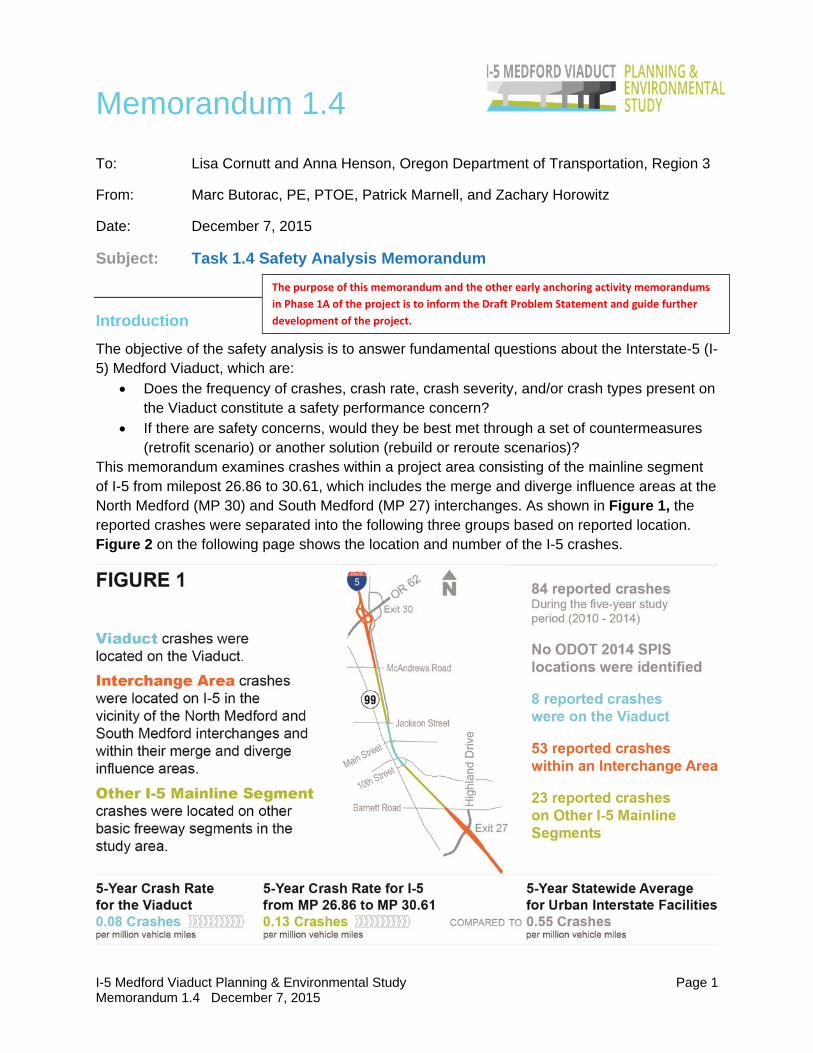
The objective of the safety analysis is to answer fundamental questions about the Interstate-5 (I-5) Medford Viaduct, which are:
Does the frequency of crashes, crash rate, crash severity, and/or crash types present on the Viaduct constitute a safety performance concern?
If there are safety concerns, would they be best met through a set of countermeasures (retrofit scenario) or another solution (rebuild or reroute scenarios)?
This memorandum examines crashes within a project area consisting of the mainline segment of I-5 from milepost 26.86 to 30.61, which includes the merge and diverge influence areas at the North Medford (MP 30) and South Medford (MP 27) interchanges. As shown in Figure 1, the reported crashes were separated into the following three groups based on reported location. Figure 2 on the following page shows the location and number of the I-5 crashes.
The purpose of this memorandum and the other early anchoring activity memorandums
in Phase 1A of the project is to inform the Draft Problem Statement and guide further
development of the project.

Berrydale Ave
Jackson Dr
Dakota Ave
Co
tta
ge
St
Austin St
Progress Dr
Tri
pp
St
Market St
W 2nd St Hillcrest Rd
Kin
g S
t
E Main St
Na
rre
ga
n S
t
Wh
itma
n A
ve
Prune St
Wa
ba
sh A
ve
Siskiyou Blvd
Cedar Links Dr
E 5th St
Alba
DrGrand Ave
Crown Ave
Merrim
an Rd
SkyparkDr
Lo
alS
t
E 6th St
W 11th St
E 3rd St
Pennington Dr
Flo
ren
ceA
ve
Will
am
ett
e A
ve
Manzanita St
N K
ee
ne
Wa
y D
r
Ga
rde
nd
ale
Ave
W 10th St
Monroe St
NH
olly
St
Taylor St
Ho
wa
rd A
ve
Su
nri
se A
ve
Gre
enbro
ok Dr
Midway Rd
Bla
ckO
ak
Dr
Arlington Dr
Alta
St
Stevens St
Capital Ave
Spring St
Holmes Ave
Pap
ago
Dr
Go
uld
Ave
W 6th St
Alm
a D
r
Po
we
ll S
t
Camellia Ave
Pe
achw
ood Ct
Pine S
t
Maple St
J St
Ash
lan
d A
ve
Ha
milt
on
St
Armory D
r
Grandview Ave
Patrick St
E Jackson St
W 13th St
Ce
da
r S
t
Be
att
y S
t
Eaton Dr
Marshall Ave
Tah
itia
n A
ve
Ha
wa
iian
Ave
Ogara St
Bra
eD
r
Hilton Rd
Duncan Dr
Reddy Ave
Hillcourt St
Perri Pl
Sun Oaks Dr
Sherman St Queen Anne Ave
Nia
ntic
St
Ruby Dr
N Fir S
t Ha
wth
orn
e S
t
Plu
m S
t
Ro
yal A
ve
W 9th St
SBar
ne
bu
r gR
d
Va
lley
Vie
w D
r
Oregon Ave
Edwards St
Ge
ne
va S
tAlice St
Liberty St
N Front S
t
Brookhurst St
S P
ea
ch S
t
S Fir St
Va
nco
uve
r A
ve
Heritage Way
S H
olly
St
S Front St
S Ivy St
Brooks ide
Dr
De Barr Ave
Evergreen St
Keene Dr
Johnson St
Mye
rs C
tS
ha
nn
on
Dr
Stratford Ave
MiraM
arAve
SM
od
ocA
ve
Ne
wto
wn
St
Pa
rk A
ve
La
ure
l St
Gra
nt A
ve
Haven St
Ra
ma
da
Ave
Hybiscus St
Roberts Rd
Murray Ave
Bro
ad
St
Lin
coln
St
Winchester Ave
Yuc
caS
t
Pennsylvania Ave
Palm St
Dellwood Ave
Woodrow Ln
Gir
ard
Dr
Fairmount St
Ch
est
nu
t S
t
BellCt
Ca
nyo
nAve
AspenSt
Ke
nw
oo
d A
ve
We
s ter
nA
v e
Ma
e S
t
Ma
ry S
t
Be
ssie
St
Ma
rie
St
Eff
ie S
t
Ke
nyo
n S
t
Lenora Dr
Hill Way
Flower St
Ridge Way
College Way
Elle
nd
ale
Dr
Lelan
dS
t
Arbor Dr
W 14th St
W 12th St
Be
nso
n S
t
Ro
ss C
t
Qu
ince
St
Ro
s eA
ve
Te
rr ace Dr
Fil m
ore
Dr
Superio r
Ct
Mye
rs L
n Kriste
n
Dr
Amaryllis St
Pin
ed
ale
St
Con co rdW
ay
Posse Ln
M o
nta
raD
r
Jasp
er
St
Easy St
Bul
lock
Rd
Po
pla
rD
r
Wh
ittle
Ave
Hig
hla
nd
Dr
Temple
Dr
Q uail
Poi
ntC
ir
Rogue Valley Manor Dr
Rosewood
St
NM
od
oc
Av e
Ge
neC
am
er o
nW
ay
Ole
ande
r St
S Grape St
Serenity Dr
Alcan Dr
Ke
lly S
t
Co
ron
a A
ve
SO
akd
ale
Ave
Sp
rin
gb
roo
k R
d
Jub
ilan
t Ave
C
o vina Ave
Po
rtla
nd
Ave
SG
rove
lan
dA
ve
Win
dsor
Ave
Crestbrook Rd
Oa
k S
t
Su
mm
it A
ve
Ly
man Ave
Rogue
Valley
Ma
ll
Wh
iteO
ak
Dr
Ro
yal C
t
E Mcandrews Rd
E Jackson St
NR
iversideA
ve
Kin
gs
Hw
y
N C
olu
mb
us
Ave
E 4th St
TableR
ockR
d
S Central Ave
N C
entral AveW Main St
Rossanle
yD
r
W 4th St
W 8th St
N Pacific Hwy
W M
cand
rews
Rd
E Barnett Rd
S C
olu
mbu
s A
ve
Stewart Ave
E Main St
Garfield St
Cra
ter
Lake
Ave
S R
iverside Ave
Center Dr
Sage Rd
S Pacific H
wy
Cra
ter L
ake
Hwy
Bidd
leR
d
Stevens St
Cou
rt S
t
HiltonRd
5
6
1
31
6
1
12
3
6
1
7
11
4
2
1
111
11
2
62
1
9
3
I-5 Medford Viaduct Planning & Environmental Study November 2015
Figure
2I-5 Mainline Crashes
(2010-2014)Medford, Oregon
H:\pr
ojfile
\1820
3 - M
edfor
d I-5
Viadu
ct Stu
dy\gi
s\Tas
k 1.4\
Cras
h Map
ping 0
1.mxd
- jso
mmerv
ille -
2:32 P
M 11
/4/20
15
Coordinate System: NAD 1983 StatePlane Oregon South FIPS 3602 Feet
Crash Locations &Number of Crashes
Viaduct
Interchange Areas
Other Mainline
Memorandum 1.4
I-5 Medford Viaduct Planning & Environmental Study Page 3 Memorandum 1.4 December 7, 2015
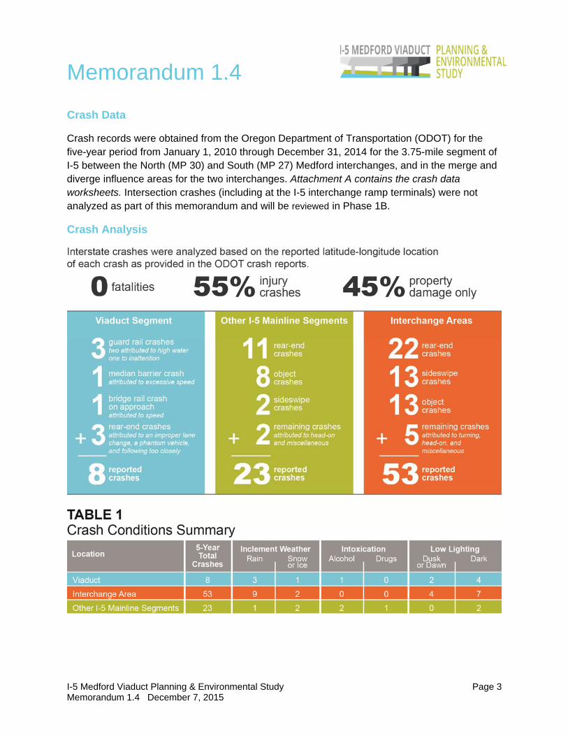
Crash Data
Crash records were obtained from the Oregon Department of Transportation (ODOT) for the five-year period from January 1, 2010 through December 31, 2014 for the 3.75-mile segment of I-5 between the North (MP 30) and South (MP 27) Medford interchanges, and in the merge and diverge influence areas for the two interchanges. Attachment A contains the crash data worksheets. Intersection crashes (including at the I-5 interchange ramp terminals) were not analyzed as part of this memorandum and will be reviewed in Phase 1B.
Crash Analysis

Memorandum 1.4
I-5 Medford Viaduct Planning & Environmental Study Page 4 Memorandum 1.4 December 7, 2015
Crash Rate Comparison
In order to compare the rate of crashes on segments of differing length the average crash rate per million vehicle miles (MVM) was calculated for the entire 3.75-mile I-5 study segment (which includes the Viaduct) as well as for the Viaduct segment alone. The crash rate is calculated using the following formula for the five-year study period.
5 5 10
365 / 5
Opportunities
Based on the analysis of the reported crash data, no hotspot safety issues were identified with the Medford Viaduct. Further detailed analysis may identify locations for spot improvements, such as those at the merge and diverge locations near the interchanges, or systemic issues that could be addressed by upgrading drainage or lighting conditions. Widening shoulders would provide additional space for drivers to recover from skids and improve mobility for incident responders. However, at the current planning analysis level, no countermeasures are proposed.
While there were no hotspot safety concerns identified on the Viaduct or within the 3.75-mile study segment of I-5 that would suggest the need to rebuild or reroute the facility, any future countermeasures or safety improvement needs at these locations should be balanced against other potential year 2040 needs (e.g., seismic) throughout the alternative development and screening process. In particular, opportunities to enhance emergency vehicle access on the Viaduct should be considered.
Attachments: Crash Data Worksheet