titlepage zoning book - cobb county...
TRANSCRIPT

Z-69 (2017)

APPLICANT: EAH Acquisitions, L.L.C. PETITION NO: Z-69
PHONE #: (770) 541-5250 EMAIL: [email protected] HEARING DATE (PC): 11-07-17
REPRESENTATIVE: J. Kevin Moore HEARING DATE (BOC): 11-21-17
PHONE #: (770) 429-1499 EMAIL: [email protected] PRESENT ZONING: R-30, R-15
TITLEHOLDER: Estate of Dorothy Henrietta Wigley
PROPOSED ZONING: R-15
PROPERTY LOCATION: West side of Wigley Road, south side
of Jamerson Road, and the northwestern corner of Wigley Road and Jims PROPOSED USE: Single-family Residential
Road Subdivision
ACCESS TO PROPERTY: Wigley Road, Jamerson Road, and SIZE OF TRACT: 12.29 acres
Jims Road DISTRICT: 16
PHYSICAL CHARACTERISTICS TO SITE: Single-family house LAND LOT(S): 98,119
and wooded, undeveloped acreage PARCEL(S): 2,3,4
TAXES: PAID X DUE
CONTIGUOUS ZONING/DEVELOPMENT COMMISSION DISTRICT: 3
NORTH: R-30/Single-family house; The Summit at
Sweat Mountain
SOUTH: R-15/Stockton Place
EAST: R-15/Hampton Ridge; Wigley Estates
WEST: R-15/Forest Chase Subdivision; Undeveloped acreage
OPPOSITION: NO. OPPOSED____PETITION NO:_____SPOKESMAN
PLANNING COMMISSION RECOMMENDATION
APPROVED______MOTION BY__________
REJECTED_______SECONDED__________
HELD____________CARRIED___________
BOARD OF COMMISSIONERS DECISION
APPROVED_______MOTION BY________
REJECTED________SECONDED_________
HELD____________CARRIED___________
STIPULATIONS:
Adjacent Future Land Use: North: Very Low Density Residential (VLDR) East: Low Density Residential (LDR) South: Low Density Residential (LDR) West: Low Density Residential (LDR)

R-15
R-15
R-30
R-30
R-15R-20
R-15
98
119
97
120
Wigle
y Rd
Jamerson Rd
Reva Dr
Duran Ct
Claridge Dr
Forest Chase Dr
Wigley
Rd
Wigle
y Esta
tes R
d
Reva Way
Forest Wood Dr
Jims Rd
R-20This map is provided for display andplanning purposes only. It is not meantto be a legal description.
Z-69 2017-GIS
Zoning BoundaryCity Boundary0 200 400
Feet
Site

APPLICANT: EAH Acquisitions, L.L.C. PETITION NO.: Z-69
PRESENT ZONING: R-30, R-15 PETITION FOR: R-15
* * * * * * * * * * * * * * * * * * * * * * * * * * * * * * * * * * * * * * * * * * * * * * * * * * * * * * * *
ZONING COMMENTS: Staff Member Responsible: Jason A. Campbell
Land Use Plan Recommendation: Low Density Residential (1-2.5 units per acre)
Proposed Number of Units: 19 Net Density: 1.72 Units/Acre*
Staff estimate for allowable # of units: 19 Units** Increase of: 0 Units/Lots *Density after subtracting 1.30 acres of floodplain from total acreage. **Estimate could be higher or lower based on engineered plans taking into account topography, shape of property, utilities, roadways,
natural features such as creeks, wetlands, etc., and other unforeseen circumstances. Approximately 8 R-30 lots and approximately 11 R-
15 lots.
Applicant is requesting the R-15 zoning district for the purpose of developing a 19-lot single-family subdivision. The houses will be a minimum of 2,500 square feet and greater and will have traditional architecture with exteriors comprised of brick, stone, cedar shake, fiber, cement siding, board and batten, and combinations thereof. The proposed site plan will require the following contemporaneous variances:
1. Waiving the side setbacks from the required 10 feet to 7.5 feet; and 2. Waiving the public road frontage and lot width to 65 feet.
Cemetery Preservation: No comment.

APPLICANT: EAH Acquisitions, L.L.C. PETITION NO.: Z-69
PRESENT ZONING: R-30, R-15 PETITION FOR: R-15
* * * * * * * * * * * * * * * * * * * * * * * * * * * * * * * * * * * * * * * * * * * * * * * * * * * * * * *
SCHOOL COMMENTS:
Number of
Capacity Portable
Name of School Enrollment Status Classrooms
Davis 560 636
Elementary
Mabry 876 1023
Middle
Lassiter 2220 2137
High
• School attendance zones are subject to revision at any time.
Additional Comments: Approval of this petition will cause concern for CCSD, as it will result in an impact on the enrollment for schools already over capacity. * * * * * * * * * * * * * * * * * * * * * * * * * * * * * * * * * * * * * * * * * * * * * * * * * * * * * *

APPLICANT: EAH Acquisitions PETITION NO.: Z-69
PRESENT ZONING: R-30, R-15 PETITION FOR: R-15/OSC
* * * * * * * * * * * * * * * * * * * * * * * * * * * * * * * * * * * * * * * * * * * * * * * * * * * * * * *
FIRE COMMENTS:
* * * * * * * * * * * * * * * * * * * * * * * * * * * * * * * * * * * * * * * * * * * * * * * * * * * * * * *
Modifications may be required to incorporate the Cobb County Fire Marshal’s Office comments. ACCESS: Fire apparatus access roads shall extend to within 150 feet of all portions of the facility or any portion of the exterior wall of the first floor (State Modifications IFC 503.1 2006 Edition). All access roads shall meet the American Association of State and Highway Transportation Officials (AASHTO) design manual live load standard HS20 (75,000 lbs.) with an unobstructed width of not less than 20 feet, 25 foot inside radius, 50 foot outside turning radius and unobstructed vertical clearance of not less than 13 feet 6 inches.

APPLICANT: EAH Acquisitions, L.L.C. PETITION NO.: Z-69 PRESENT ZONING: R-30 & R-15 PETITION FOR: R-15
* * * * * * * * * * * * * * * * * * * * * * * * * * * * * * * * * * * * * * * * * * * * * * * * * * * * * PLANNING COMMENTS:
The applicant is requesting a rezoning from R-30 and R-15 to R-15 for the purpose of a single-
family residential subdivision. The 12.29 acre site is located in the west side of Wigley Road,
south side of Jamerson Road, and the northwestern corner of Wigley Road and Jims Road.
HB-489 Intergovernmental Agreement Zoning Amendment Notification:
Is the application site within one half (1/2) mile of a city boundary? Yes No
If yes, has the city of ______ been notified? Yes No / N/A
Comprehensive Plan
The parcel is within a Low Density Residential (LDR) future land use category, with R-30 and
R-15 zoning designation. The purpose of the Low Density Residential (LDR) category is to
provide for areas that are suitable for low density housing between one (1) and two and one-half
(2.5) dwelling units per acre. This category presents a range of densities.
Specific Area Policy Guidelines:
There are no specific policy guidelines for this area in the Comprehensive Plan.
Adjacent Future Land Use:
North: Very Low Density Residential (VLDR)
East: Low Density Residential (LDR)
South: Low Density Residential (LDR)
West: Low Density Residential (LDR)
Master Plan/Corridor Study
The property is not located within the boundary of a Plan or Corridor Study
Historic Preservation
After consulting various county historic resources surveys, historic maps, archaeology surveys and
Civil War trench location maps, staff finds that no known significant historic resources appear to
be affected by this application. No further comment. No action by applicant requested at this
time.
Design Guidelines Is the parcel in an area with Design Guidelines? Yes No
If yes, design guidelines area __________________________________
Does the current site plan comply with the design requirements?
Incentive Zones
Is the property within an Opportunity Zone? Yes No
The Opportunity Zone is an incentive that provides $3,500 tax credit per job in eligible areas if
two or more jobs are being created. This incentive is available for new or existing businesses.

APPLICANT: EAH Acquisitions, L.L.C. PETITION NO.: Z-69 PRESENT ZONING: R-30 & R-15 PETITION FOR: R-15
* * * * * * * * * * * * * * * * * * * * * * * * * * * * * * * * * * * * * * * * * * * * * * * * * * * * * PLANNING COMMENTS:
CONT.
Is the property within an Enterprise Zone? Yes No
The ___________ Enterprise Zone is an incentive that provides tax abatements and other
economic incentives for qualifying businesses locating or expanding within designated areas for
new jobs and capital investments.
Is the property eligible for incentives through the Commercial and Industrial Property
Rehabilitation Program? Yes No
The Commercial and Industrial Property Rehabilitation Program is an incentive that provides a
reduction in ad valorem property taxes for qualifying redevelopment in eligible areas.
For more information on incentives, please call the Community Development Agency, Planning
Division at 770.528.2018 or find information online at http://economic.cobbcountyga.gov.
Special Districts
Is this property within the Cumberland Special District #1 (hotel/motel fee)?
Yes No
Is this property within the Cumberland Special District #2 (ad valorem tax)?
Yes No
Is this property within the Six Flags Special Service District?
Yes No
Is the property within the:
Dobbins Airfield Safety Zone?
CZ (Clear Zone)
APZ I (Accident Potential Zone I)
APZ II (Accident Potential Zone II)
Noise Zone
Bird / Wildlife Air Strike Hazard (BASH) area
.org.

APPLICANT EAH Acquisitions, L.L.C. PETITION NO. Z-069
PRESENT ZONING R-30, R-15 PETITION FOR R-15 OSC
* * * * * * * * * * * * * * * * * * * * * * * * * * * * * * * * * * * * * * * * * * * * * * * * * * * * * * * * *
NOTE: Comments reflect only what facilities were in existence at the time of this review.
Size / Location of Existing Water Main(s): 8" CI / W side of Wigley Road
Additional Comments:
Developer may be required to install/upgrade water mains, based on fire flow test results or Fire Department Code. This will be resolved in the Plan Review Process.
SEWER COMMENTS:
Available at Development: NoYes
WATER COMMENTS:
Fire Flow Test Required: Yes No
In Drainage Basin: Yes No
At Development: Yes No
Estimated Waste Generation (in G.P.D.):
Approximate Distance to Nearest Sewer: At northern and southern edges of property
3,520A D F= 8,800Peak=
Treatment Plant: Noonday
Plant Capacity: Available Not Available
Line Capacity: Available Not Available
Projected Plant Availability: 0 - 5 years 5 - 10 years over 10 years
Dry Sewers Required: Yes No
Off-site Easements Required: Yes* No
Flow Test Required: Yes No
Letter of Allocation issued: Yes
Septic Tank Recommended by this Department: Yes
No
Subject to Health Department Approval: Yes No
Additional Comments:
Developer will be responsible for connecting to the existing County water and sewer systems, installing and/or upgrading all outfalls and water mains, obtaining on and/or offsite easements, dedication of on and/or offsite water and sewer to Cobb County, as may be required. Rezoning does not guarantee water/sewer availability/capacity unless so stated in writing by the Cobb County Water System. Permit issuances subject to continued treatment plant compliance with EPD discharge requirements.
NOTE: Comments reflect only what facilities were in existence at the time of this review.
* * * * * * * * * * * * * * * * * * * * * * * * * * * * * * * * * * * * * * * * * * * * * * * * * * * * * * * *
No
*If off-site easements are required, Developer must submit easements to CCWS for review/approval as to form and stipulations prior to the execution of easements by the property owners. All easement acquisitions are the responsibility of the Developer
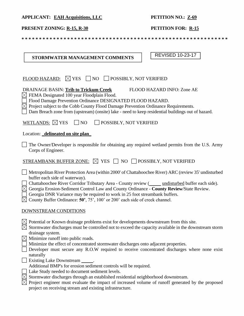
APPLICANT: EAH Acquisitions, LLC PETITION NO.: Z-69 PRESENT ZONING: R-15, R-30 PETITION FOR: R-15 * * * * * * * * * * * * * * * * * * * * * * * * * * * * * * * * * * * * * * * * * * * * * * * * * * * * * * * * * * *
STORMWATER MANAGEMENT COMMENTS
FLOOD HAZARD: YES NO POSSIBLY, NOT VERIFIED
DRAINAGE BASIN: Trib to Trickum Creek FLOOD HAZARD INFO: Zone AE FEMA Designated 100 year Floodplain Flood. Flood Damage Prevention Ordinance DESIGNATED FLOOD HAZARD.
Project subject to the Cobb County Flood Damage Prevention Ordinance Requirements.
Dam Breach zone from (upstream) (onsite) lake - need to keep residential buildings out of hazard.
WETLANDS: YES NO POSSIBLY, NOT VERIFIED
Location: _delineated on site plan_
The Owner/Developer is responsible for obtaining any required wetland permits from the U.S. Army
Corps of Engineer.
STREAMBANK BUFFER ZONE: YES NO POSSIBLY, NOT VERIFIED
Metropolitan River Protection Area (within 2000' of Chattahoochee River) ARC (review 35' undisturbed
buffer each side of waterway).
Chattahoochee River Corridor Tributary Area - County review ( undisturbed buffer each side).
Georgia Erosion-Sediment Control Law and County Ordinance - County Review/State Review.
Georgia DNR Variance may be required to work in 25 foot streambank buffers.
County Buffer Ordinance: 50’, 75’, 100’ or 200’ each side of creek channel.
DOWNSTREAM CONDITIONS
Potential or Known drainage problems exist for developments downstream from this site.
Stormwater discharges must be controlled not to exceed the capacity available in the downstream storm
drainage system.
Minimize runoff into public roads.
Minimize the effect of concentrated stormwater discharges onto adjacent properties.
Developer must secure any R.O.W required to receive concentrated discharges where none exist
naturally
Existing Lake Downstream . Additional BMP's for erosion sediment controls will be required.
Lake Study needed to document sediment levels.
Stormwater discharges through an established residential neighborhood downstream.
Project engineer must evaluate the impact of increased volume of runoff generated by the proposed
project on receiving stream and existing infrastructure.
REVISED 10-23-17

APPLICANT: EAH Acquisitions, LLC PETITION NO.: Z-69 PRESENT ZONING: R-15, R-30 PETITION FOR: R-15 * * * * * * * * * * * * * * * * * * * * * * * * * * * * * * * * * * * * * * * * * * * * * * * * * * * * * * * *
STORMWATER MANAGEMENT COMMENTS – Continued
SPECIAL SITE CONDITIONS
Provide comprehensive hydrology/stormwater controls to include development of out parcels.
Submit all proposed site improvements to Plan Review.
Any spring activity uncovered must be addressed by a qualified geotechnical engineer (PE).
Structural fill must be placed under the direction of a qualified registered Georgia geotechnical
engineer (PE).
Existing facility.
Project must comply with the Water Quality requirements of the CWA-NPDES-NPS Permit and County
Water Quality Ordinance.
Water Quality/Quantity contributions of the existing lake/pond on site must be continued as baseline
conditions into proposed project.
Calculate and provide % impervious of project site.
Revisit design; reduce pavement area to reduce runoff and pollution.
INSUFFICIENT INFORMATION
No Stormwater controls shown
Copy of survey is not current – Additional comments may be forthcoming when current site conditions
are exposed.
No site improvements showing on exhibit.
ADDITIONAL COMMENTS
1. This site is located to the south and west of Jamerson and Wigley Roads just north of the its
intersection with Jims Road. The site is encumbered by floodplain and the associated stream buffer
of Trickum Creek Tributary which flows northwesterly through the property. The site is currently
wooded and undeveloped with the exception of a single existing residential parcel. Slopes on the
site range widely from approximately 7 to 40%.
2. The proposed footbridge over the stream will require a FEMA no-rise certification and possibly a
CLOMR submittal to FEMA.
3. It does not appear that sufficient site area has been reserved to provide adequate stormwater
management.
REVISED 10-23-17
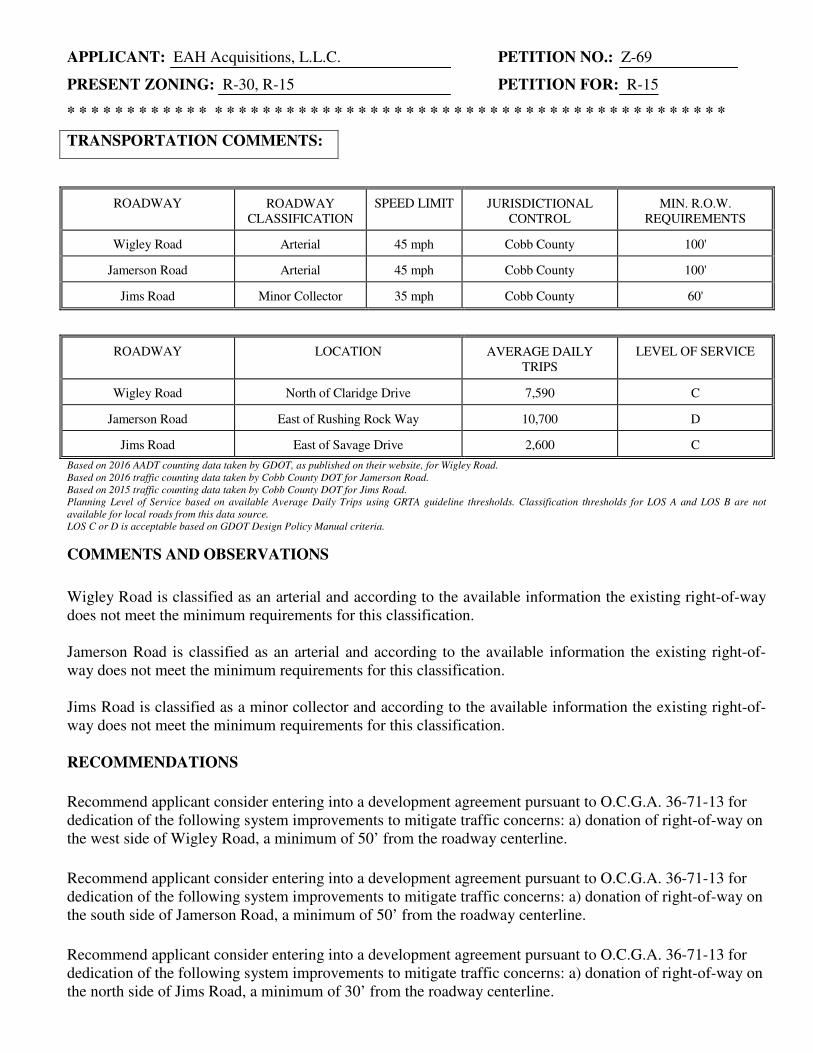
APPLICANT: EAH Acquisitions, L.L.C. PETITION NO.: Z-69
PRESENT ZONING: R-30, R-15 PETITION FOR: R-15/OSC
* * * * * * * * * * * * * * * * * * * * * * * * * * * * * * * * * * * * * * * * * * * * * * * * * * * * * * *
TRANSPORTATION COMMENTS:
ROADWAY ROADWAY CLASSIFICATION
SPEED LIMIT JURISDICTIONAL CONTROL
MIN. R.O.W. REQUIREMENTS
Wigley Road Arterial 45 mph Cobb County 100'
Jamerson Road Arterial 45 mph Cobb County 100'
Jims Road Minor Collector 35 mph Cobb County 60'
ROADWAY LOCATION AVERAGE DAILY TRIPS
LEVEL OF SERVICE
Wigley Road North of Claridge Drive 7,590 C
Jamerson Road East of Rushing Rock Way 10,700 D
Jims Road East of Savage Drive 2,600 C
Based on 2016 AADT counting data taken by GDOT, as published on their website, for Wigley Road.
Based on 2016 traffic counting data taken by Cobb County DOT for Jamerson Road.
Based on 2015 traffic counting data taken by Cobb County DOT for Jims Road.
Planning Level of Service based on available Average Daily Trips using GRTA guideline thresholds. Classification thresholds for LOS A and LOS B are not
available for local roads from this data source.
LOS C or D is acceptable based on GDOT Design Policy Manual criteria.
COMMENTS AND OBSERVATIONS
Wigley Road is classified as an arterial and according to the available information the existing right-of-way does not meet the minimum requirements for this classification. Jamerson Road is classified as an arterial and according to the available information the existing right-of-way does not meet the minimum requirements for this classification. Jims Road is classified as a minor collector and according to the available information the existing right-of-way does not meet the minimum requirements for this classification.
RECOMMENDATIONS
Recommend applicant consider entering into a development agreement pursuant to O.C.G.A. 36-71-13 for dedication of the following system improvements to mitigate traffic concerns: a) donation of right-of-way on the west side of Wigley Road, a minimum of 50’ from the roadway centerline.
Recommend applicant consider entering into a development agreement pursuant to O.C.G.A. 36-71-13 for dedication of the following system improvements to mitigate traffic concerns: a) donation of right-of-way on the south side of Jamerson Road, a minimum of 50’ from the roadway centerline.
Recommend applicant consider entering into a development agreement pursuant to O.C.G.A. 36-71-13 for dedication of the following system improvements to mitigate traffic concerns: a) donation of right-of-way on the north side of Jims Road, a minimum of 30’ from the roadway centerline.

APPLICANT: EAH Acquisitions, L.L.C. PETITION NO.: Z-69
PRESENT ZONING: R-30, R-15 PETITION FOR: R-15/OSC
* * * * * * * * * * * * * * * * * * * * * * * * * * * * * * * * * * * * * * * * * * * * * * * * * * * * * * *
Recommend applicant be required to meet all Cobb County Development Standards and Ordinances related to project improvements.
Recommend relocating the driveway on Jims Road a minimum of 250 feet from the intersection of Wigley Road. Recommend applicant verify that minimum intersection sight distance requirement of 500' is available for Jamerson Road access and if it is not, restrict access to right out only. Recommend private streets be constructed to the Cobb County Standard Specifications. Recommend a no access easement for the lots along the frontage of Wigley Road and Jamerson Road.

STAFF RECOMMENDATIONS
Z-69 EAH ACQUISITIONS, L.L.C.
A. It is Staff's opinion that the applicant's rezoning proposal will permit a use that is suitable in view of
the use and development of adjacent and nearby properties. Other properties in this area are zoned for single-family residential uses at similar densities.
B. It is Staff's opinion that the applicant's rezoning proposal will not have an adverse effect on the
usability of adjacent or nearby property. Other single-family developments in this area include: The Summit at Sweat Mountain (zoned R-30 at 0.72 units per acre); Bluffs at Jamerson (zoned R-20 at approximately 1.89 units per acre); Hampton Ridge Unit IV (zoned R-15 at 1.659 units per acre); Forest Chase Unit No. 1 (zoned R-15 at 2.146 units per acre); and Stockton Place (zoned R-15 at 2.22 units per acre).
C. It is Staff's opinion that the applicant's rezoning proposal will not result in a use which would cause
an excessive or burdensome use of existing streets, transportation facilities, or utilities. However, the Cobb County School System is concerned that approval of this application will have an impact on the enrollment of an over-capacity school. This opinion can be supported by the departmental comments contained in this analysis.
D. It is Staff's opinion that the applicant's rezoning proposal is in conformity with the policy and intent
of the Cobb County Comprehensive Plan, which delineates this property as being within the Low Density Residential (LDR) future land use category. The LDR category has a density range of 1 to 2.5 units per acre. The proposed density of 1.72 units per acre is within the LDR density range and is of similar density to surrounding single-family subdivisions.
E. It is Staff's opinion that there are existing and changing conditions affecting the use and development of the property, which give supporting grounds for approving the applicant's rezoning proposal. The applicant’s proposal is consistent with surrounding R-15 residential subdivisions in this area.
Based on the above analysis, Staff recommends APPROVAL subject to the following conditions:
1. Site plan received by the Zoning Division on October 24, 2017, with the District Commissioner approving minor modifications;
2. Fire Department comments and recommendations; 3. Water and Sewer Division comments and recommendations; 4. Stormwater Management Division comments and recommendations; 5. Department of Transportation comments and recommendations; and 6. Owner/developer to enter into a Development Agreement pursuant to O.C.G.A. §36-71-13 for
dedication of system improvements to mitigate traffic concerns.
The recommendations made by the Planning and Zoning Staff are only the opinions of the Planning
and Zoning Staff and are by no means the final decision. The Cobb County Board of Commissioners
makes the final decisions on all Rezoning and Land Use Permits at an advertised public hearing.
