title: technical id - nopsema · site survey program (dillon and cash-maple) environment plan...
TRANSCRIPT

Title: Site Survey Program (Dillon and Cash-Maple) Environment Plan Summary
Technical ID: CORP-HSE-D12-836787
Technical#836787 Rev 0 Page 2 of 22
TABLE OF CONTENTS 1 INTRODUCTION ..................................................................................................... 3 2 LOCATION OF ACTIVITY ...................................................................................... 3 3 DESCRIPTION OF ACTIVITY ................................................................................ 7 4 DESCRIPTION OF RECEIVING ENVIRONMENT .................................................. 7 5 ENVIRONMENTAL RISK ASSESSMENT ............................................................ 14 6 MANAGEMENT APPROACH ............................................................................... 15 7 STAKEHOLDER CONSULTATION ..................................................................... 15 8 CONTACT DETAILS ........................................................................................... 16 9 REFERENCES ...................................................................................................... 17
TABLE OF FIGURES Figure 1: Regional Setting .................................................................................................................................. 5
Figure 2: SSP Areas and Surrounding Title Areas ............................................................................................. 6
TABLE OF TABLES Table 1: Well and Survey Area Locations .......................................................................................................... 4
Table 2: Summary of Survey Activities ............................................................................................................... 7
Table 3: EPBC Protected Species - Threatened and Migratory Species ........................................................... 8 Table 4: Project Hazards .................................................................................................................................. 14
APPENDICES Appendix A Environmental Risk Assessment Summary

Title: Site Survey Program (Dillon and Cash-Maple) Environment Plan Summary
Technical ID: CORP-HSE-D12-836787
Technical#836787 Rev 0 Page 3 of 22
1 INTRODUCTION PTTEP AA Australasia (Ashmore Cartier) Pty Ltd (PTTEP AA), a wholly owned subsidiary of PTTEP Australia Perth Pty Ltd and part of the PTTEP Australasia Group, plans to conduct pre-drilling site survey activities at following proposed well locations: Dillon South-1 located in petroleum title AC/P4, Maple East-1 in AC/P54 and Maple-3 and Cash-3 in AC/RL7 (herein termed the Site Survey Program (SSP)). The survey is planned to be undertaken between August and October 2013 for a total duration of between 14 and 28 days.
An Environment Plan (EP) was prepared for this SSP and accepted by the National Offshore Petroleum Safety and Environmental Management Authority (NOPSEMA) on the 9th of July 2013 in accordance with the Offshore Petroleum and Greenhouse Gas Storage (Environment) Regulations 2009.
This EP summary document has been prepared to comply with the requirements of Regulation 11(7) and (8) of the Offshore Petroleum and Greenhouse Gas Storage (Environment) Regulations 2009.
2 LOCATION OF ACTIVITY The SSP is within petroleum titles AC/P4, AC/P54 and AC/RL7 located in the Timor Sea approximately 600 km west of Darwin and 750km northeast of Broome (Figures 1 & 2). Within these title areas there are four site surveys to be completed at the proposed drilling locations (provided in Table 1). The survey covers approximately 4.5 km2 areas around each proposed well location.
The title areas are in the Vulcan sub-basin, located in the northern Bonaparte Basin. The Vulcan sub-basin is a northeast-trending geological structure comprising a complex series of horsts, graben and marginal terraces (DRET, 2010). The Vulcan sub-basin hosts proven oil resources as well as a number of gas resources currently under exploration. Water depth within the site survey areas ranges from approximately 100 to 200 m.
Title: Site Survey Program (Dillon and Cash-Maple) Environment Plan Summary
Technical ID: CORP-HSE-D12-836787
Technical#836787 Rev 0 Page 4 of 22
Table 1: Well and Survey Area Locations
Title area Well and Survey Area Latitude Longitude
AC/P4 Dillon South-1 (Well Location) 110 16' 29'' S 1250 25’ 45.395” E
NW Corner Point 11 15' 55'' S 1250 25’ 09” E
NE Corner Point 110 15' 54'' S 1250 26’ 19” E
SE Corner Point 110 17' 03'' S 1250 26’ 20” E
SW Corner Point 110 17' 04'' S 1250 25’ 10” E
AC/RL7 Cash-3 (Well Location) 110 56' 30.2” S 1240 36’ 41.6” E
NW Corner Point 110 55' 55'' S 1250 36’ 06” E
NE Corner Point 110 55' 55'' S 1250 37’ 16” E
SE Corner Point 110 17' 04'' S 1250 37’ 16” E
SW Corner Point 110 17' 04'' S 1250 36’ 06” E
AC/RL7 Maple-3 (Well Location) 120 00' 21.4'' S 1240 34’ 31.7” E
NW Corner Point 110 59' 46'' S 1240 33’ 56” E
NE Corner Point 110 59' 46'' S 1250 35’ 06” E
SE Corner Point 120 00' 55'' S 1250 35’ 06” E
SW Corner Point 120 00' 55'' S 1240 33’ 56” E
AC/P54 Maple East-1 (Well Location) 110 59' 38.56” S 1240 40’ 27.04” E
NW Corner Point 110 59' 04'' S 1240 39’ 51” E
NE Corner Point 110 59' 03'' S 125041’ 01” E
SE Corner Point 120 00' 12'' S 125041’ 02” E
SW Corner Point 120 00' 13'' S 1240 39’ 51” E
Note: GDA94
Title: Site Survey Program (Dillon and Cash-Maple) Environment Plan Summary
Technical ID: CORP-HSE-D12-836787
Technical#836787 Rev 0 Page 5 of 22
Figure 1: Regional Setting

Title: Site Survey Program (Dillon and Cash-Maple) Environment Plan Summary
Technical ID: CORP-HSE-D12-836787
Technical#836787 Rev 0 Page 6 of 22
Figure 2: SSP Areas and Surrounding Title Areas

Title: Site Survey Program (Dillon and Cash-Maple) Environment Plan Summary
Technical ID: CORP-HSE-D12-836787
Technical#836787 Rev 0 Page 7 of 22
3 DESCRIPTION OF ACTIVITY The survey areas cover approximately 4.5 km2 around each proposed well location to obtain information on bathymetry, seabed features and shallow geology to assist in the drilling program with the rig installation.
The SSP will include operation of multibeam echo sounder, sub-bottom profiler, sidescan sonar data and sediment samples acquired via grab sampler to provide accurate measurements of:
• Water depth and seabed topography.
• Seabed types including nature and distribution.
• Potential seafloor and sub-seafloor obstructions.
Field activities are expected to require between 3 to 5 days at each survey area to complete and are summarised below in Table 2.
Table 2: Summary of Survey Activities
Title of Activity: PTTEP AA Site Survey Program
Location: Four survey areas in the northern Bonaparte Basin (Refer Table 1)
Activity Timing: The survey is scheduled to be undertaken between August and October 2013 for a total duration of between 14 and 28 days.
Purpose: To obtain geophysical data prior to mobilisation of drilling rig to location, in particular:
• Accurately measure water depths and map seabed topography across the survey areas.
• Through the use of sidescan sonar acquisition, identify and map the nature and distribution of seabed types within the survey areas.
• Characterise and map the thickness, distribution and nature of unconsolidated surficial sediments across the survey areas.
• Identify and report on potential seabed obstructions/hazards which could interfere with positioning of semi‐submersible drilling rigs.
• Confirm presence or lack thereof of shallow gas prior to commencement of drilling.
• Reduce potential risks/hazards for future proposed drilling at the locations.
4 DESCRIPTION OF RECEIVING ENVIRONMENT
4.1 PHYSICAL AND BIOLOGICAL ENVIRONMENT The survey areas are located on the Australian continental shelf in the Timor Sea. In general, the continental shelf is a flat featureless submarine plain that dips gently northward toward the edge of the shelf, but scattered throughout the region are sea mounts, shoals and occasional islands that support a diverse flora and fauna. The Timor Trough, with water depths up to 9,000 m, marks the northern boundary of the continental shelf.
The survey areas are located in the Timor Province Bioregion of the Northwest Shelf Transition Bioregion and within the larger Northwest Marine Region (NWMR) Planning Area. The variety of geomorphic features in the Timor Province results in several distinct habitats and biological communities, many of which are in close proximity to each other. The reefs and islands of the

Title: Site Survey Program (Dillon and Cash-Maple) Environment Plan Summary
Technical ID: CORP-HSE-D12-836787
Technical#836787 Rev 0 Page 8 of 22
bioregion are regarded as particular hotspots for biodiversity and support a range of important pelagic and benthic ecological communities. A high level of endemism has been identified in demersal fish communities of the continental slope in the Timor Province, with two distinct communities identified (upper slope and mid slope).
The Timor Province Bioregion includes Ashmore Reef, Cartier Island, Hibernia Reef, Seringapatam Reef and Scott Reef all Commonwealth marine protected areas. These reefs, in particular Ashmore Reef, are recognised as having the highest richness and diversity of coral species in WA with the nearest being Cartier Island which is approximately 120 km to the southwest of the nearest survey area.
The SSP survey areas are located on the Australian continental shelf in approximately between 100 to 200m depth of water. The seafloor of the outer continental shelf is characterised by clayey-silts to sand-sized marine carbonate sediments (LeProvost Dames & Moore, 1997).
Seabed surveys have been conducted in the nearby Challis Field (approximately 40 km from the Cash Maple site survey areas and 80km from Dillon South-1 survey area) and identified this region as predominantly comprised of soft sediment with little topographic relief, and subsequently little diversity in habitat (URS, 2002).
Protected Fauna A search of the EPBC database (Protected Matters Search Tool; administered by DSEWPaC) was undertaken, applying a conservative 16 km radius from proposed survey area locations to identify any matters of NES; and in particular protected species and habitat. The protected species (Threatened and/or Migratory) are included in Table 3, combining all the locations i.e. the 4 survey areas in the 3 title areas with any variations identified.
The species listed are discussed briefly in the following sections on the basis of their occurrence at various times of the year combined, and are generally found as transient visitors to the area during migration and feeding. No known breeding grounds or sensitive habitats critical to the species highlighted are known to exist within, or in close proximity to the site survey areas.
Table 3: EPBC Protected Species - Threatened and Migratory Species
Scientific Name Common Name Status Type of Presence
Cetaceans
Balaenoptera musculus
Blue whale Endangered, Migratory
Species/ species habitat may occur within area
Megaptera novaeangliae
Humpback whale Vulnerable, Migratory
Species/ species habitat may occur within area
Balaenoptera bonaerensis
Antarctic minke whale
Migratory Species/ species habitat may occur within area
Balaenoptera edeni
Bryde’s whale Migratory Species/ species habitat may occur within area
Physeter macrocephalus
Sperm whale Migratory Species/ species habitat may occur within area
Orcinus orca Killer whale, orca Migratory Species/ species habitat may occur within area
Tursiops aduncus Spotted Bottlenose Dolphin (Arafura/Timor Sea populations)
Migratory Species/ species habitat may occur within area (Cash/Maple Survey Areas)
Marine Reptiles
Caretta caretta Loggerhead turtle Endangered, Migratory
Species/ species habitat likely to occur within area (Cash/Maple Survey Areas) Species/ species habitat may occur within area (Dillon South-1)

Title: Site Survey Program (Dillon and Cash-Maple) Environment Plan Summary
Technical ID: CORP-HSE-D12-836787
Technical#836787 Rev 0 Page 9 of 22
Chelonia mydas Green turtle Vulnerable, Migratory
Species/ species habitat known to occur within area
Dermochelys coriacea
Leatherback turtle Endangered, Migratory
Species/ species habitat likely to occur within area (Cash/Maple Survey Areas) Species/ species habitat may occur within area (Dillon South-1)
Eretmochelys imbricata
Hawksbill turtle Vulnerable, Migratory
Species/ species habitat likely to occur within area (Cash/Maple Survey Areas) Species/ species habitat may occur within area (Dillon South-1)
Lepidochelys olivacea
Olive ridley turtle Endangered, Migratory
Species/ species habitat likely to occur within area (Cash/Maple Survey Areas) Species/ species habitat may occur within area (Dillon South-1)
Natator depressus Flatback turtle Vulnerable, Migratory
Species/ species habitat known to occur within area (Dillon South-1) Species/ species habitat likely to occur within area (Cash/Maple Survey Activity Area)
Sharks
Rhincodon typus Whale shark Vulnerable, Migratory
Foraging, feeding or related behaviour known to occur within area (Cash/Maple Survey Areas)
Isurus oxyrinchus Shortfin mako Migratory Species/ species habitat likely to occur within area (Cash/Maple Survey Areas)
Isurus paucus Longfin mako Migratory Species/ species habitat likely to occur within area (Cash/Maple Survey Areas)
Marine Birds
Calonectris leucomelas/ Puffinus leucomelas
Streaked shearwater
Migratory Species/ species habitat may occur within area
Anous tenuirostris melanops
Australian Lesser Noddy
Vulnerable Species/ species habitat may occur within area (Cash/Maple Survey Areas)
Bony Fish Based on the flat, generally featureless and low diversity of habitat of the majority of the SSP areas it is reasonable to conclude that pelagic fish species may traverse the area but not aggregate in large numbers. However, greater fish abundance is known to occur in the shallow, coastal fringe at the edge of the continental shelf and around reefs and shoals e.g. Vulcan and Barracouta Shoals, Hibernia and Ashmore Reefs and Cartier Island. Fish abundance is therefore likely to be higher in areas associated with the shoals and/or seamounts – neither of which has been identified in the SSP areas. The broader area of the Timor Sea supports a variety of shark and pelagic finfish species of commercial and recreational game-fishing importance.
It is also noted that large aggregations of fish including snapper (Lutjanidae), mackerel (Scombridae), trevally (Carangidae), trout and cod (Serranidae), batfish (Ephippidae), angelfish (Pomacanthidae), butterflyfish (Chaetodontidae) and damselfish (Pomacentridae) were evident in ROV video records of the mooring base and mooring of the oil production facility of the nearby Challis Field (Clough, 1997).
Sharks The EPBC Act Protected Matters search identified 3 migratory shark species that may occur in or have habitat in the survey areas.
Title: Site Survey Program (Dillon and Cash-Maple) Environment Plan Summary
Technical ID: CORP-HSE-D12-836787
Technical#836787 Rev 0 Page 10 of 22
Whale sharks (Rhincodon typus) are listed as Vulnerable and Migratory under the EPBC Act and Vulnerable under the World Conservation Union’s ‘Red List’ of Threatened Species (IUCN 2012). They are generally found in areas where the surface temperature is 21–25 °C, preferably with cold water of 17 °C or less upwelling into it, and salinity of 34.0 to 34.5 parts per thousand (ppt) (Pogonoski et al. 2002). Whale sharks have a broad distribution in tropical and warm temperate seas. In Australian waters, they are known to aggregate at Ningaloo Reef (approximately 1,500 km south-west of the SSP areas) sometime between May and June and in the Queensland Coral Sea (approximately 2,400 km east of the Licence Area) between November and December. The Whale shark is a highly migratory fish and only visits Australian waters seasonally (DSEWPAC 2013a). Whale sharks have been identified as having feeding, foraging or related behaviour in the Dillon South-1 site survey area. Based on this whale sharks may be encountered during the survey in the Dillon South-1 survey area but unlikely to be encountered in significant numbers.
The shortfin mako (Isurus oxyrinchus) and the longfin mako (Isurus paucus) are offshore epipelagic species found in tropical and warm-temperate waters. Both species occur in Australia in coastal waters off WA, NT, QLD and NSW at depths ranging from shallow coastal waters to at least 500 metres. These species may transit through the survey areas.
Marine Mammals The DSEWPaC Protected Matters database did not identify known foraging, feeding, breeding or aggregation areas for marine mammal species within 5 km of the survey areas. However, transient marine mammal species have the potential to traverse the survey area; therefore descriptions on the known distribution and occurrence of potential transient species within the survey area are provided below.
Two species are listed as threatened under the EPBC Act and may occur in or around the SSP.
• Blue Whale (endangered/migratory).
• Humpback Whale (vulnerable/migratory).
Blue Whale (Endangered/Migratory) Blue whales (Balaenoptera musculus) are widely distributed throughout the worlds’ oceans. It is generally accepted that there are two subspecies in the Southern Hemisphere: the southern blue whale (Balaenoptera musculus intermedia) and the pygmy blue whale (Balaenoptera musculus brevicauda) (DEWHA, 2008). In general, the southern blue whale is found south of 60° S and pygmy blue whales are found north of 55°S (DEWHA, 2008), it is therefore likely that any blue whales encountered in the waters surrounding the SSP would be pygmy blue whales.
Blue whale migration is thought to follow deep oceanic routes, although little is known about their precise migration routes (DSEWPaC 2013a). Sea noise loggers set at various locations along the coast of Western Australia have detected an annual northbound and southbound migration of pygmy blue whales past Exmouth and the Montebello Islands and locations to the north (McCauley and Jenner, 2010). Pygmy Blue whales appear to migrate south from Indonesian waters passing Exmouth through November to late December each year. Observations suggest most Pygmy Blue whales pass along the shelf edge out to water depths of 1,000 m but centred near the 500 m depth contour. The northern migration passes Exmouth over an extended period ranging from April to August (McCauley and Jenner, 2010).
The Perth Canyon is the only area so far identified off the Western Australia coast where Pygmy Blue whales aggregate with some predictability (over 2,500 km south of the survey areas). The area represents a significant feeding ground for Pygmy Blue whales between January and April (McCauley and Jenner, 2010). Blue whales are believed to calve in tropical waters in winter and births peak in May to June, however the exact breeding grounds of this species are unknown (Bannister et al, 1996).
The SSP area does not include any recognised Blue whale migratory routes or known feeding, breeding or resting areas. However, Blue whales may occasionally pass through the area. Therefore the likelihood of encountering Blue whales is considered low based on the survey being outside their recognised migratory routes and any recognised feeding, breeding or resting areas.
Title: Site Survey Program (Dillon and Cash-Maple) Environment Plan Summary
Technical ID: CORP-HSE-D12-836787
Technical#836787 Rev 0 Page 11 of 22
Humpback Whale (Vulnerable/Migratory) Humpback whales (Megaptera novaeangliae) also have a wide distribution and have been recorded in coastal areas off all Australian states except the Northern Territory (Bannister et al., 1996). Humpback whales migrate north and south along the eastern and western coasts of Australia from calving grounds in the tropical north to feeding grounds in the Southern Ocean (DEH, 2006).
Peak northward migration off the north-western coast of Australia occurs from late July to early August and peak southward migration from late August to early September (Jenner et al., 2001). From June to mid-September the inshore waters (landward of the 100 m isobath) between the Lacepede Islands and Camden Sound are used as a calving area for this species (Jenner et al., 2001).
The DSEWPaC Protected Matters database indicates that Humpback whales may occur in the SSP areas, however, there are no recognised Humpback whale migratory routes within or near the survey areas (the closest significant habitat is Camden Sound approximately 600 km south-west of the survey area). With the well location/survey areas being in the Timor Sea, this would be an extreme N/NWW migration.
Therefore the likelihood of encountering Humpback whales is considered low based on the SSP being outside their recognised migratory routes and any recognised feeding, breeding or resting areas.
Other Migratory Cetaceans In addition to the Humpback whale and Blue whale, five other migratory cetacean species have the potential to occur within the SSP areas:
• Antarctic Minke whale.
• Bryde’s whale.
• Killer whale.
• Sperm whale.
• Indo-Pacific/Spotted Bottlenose Dolphin (Arafura/Timor Sea population only).
Antarctic Minke Whales are found throughout much of Australia’s coastal waters. Antarctic Minke Whales have been recorded from all States but not in the Northern Territory (Bannister et al., 1996). The paucity of records of the colouration of stranded Minke Whales in Australia obscures the determination of the range of Antarctic Minke Whales along the Australian coast, although they are known to occur north to 21°S off the east coast (Bannister et al., 1996). The distribution up the west coast of Australia is currently unknown. Antarctic Minke Whales probably do not migrate as far north as Dwarf Minke Whales (to 11°S) (Bannister et al., 1996; Perrin & Brownell, 2002), This species’ winter breeding areas are thought to be relatively dispersed in open ocean areas throughout tropical and sub-tropical latitudes, but they congregate in Antarctic waters during the summer feeding season.
Bryde's whales have been recorded from all Australian states except the Northern Territory (Bannister et al., 1996), Bryde's whales are not gregarious and mostly swim alone or in pairs. The largest reported group sizes of 10 to 23 individuals are usually loose aggregations covering a few square kilometres in area (Martin, 1990). The association of individuals may therefore be coincidental and connected to a common activity, such as feeding. No specific feeding or breeding grounds of the Bryde’s whale have been discovered off Australia. The inshore form appears to be resident in waters containing suitable prey stocks of pelagic shoaling fishes, while the offshore form appears to undergo extensive migrations between subtropical and tropical waters during the winter months (Best, 1977).
In Australia, killer whales are recorded from all states, with concentrations reported around Tasmania. Sightings are also frequent in South Australia and Victoria (Ling, 1991). A sighting at Yirrkala in April 1999 provides evidence that they also occur in Northern Territory waters (Chatto & Warneke, 2000). Killer Whales are frequently seen in the Antarctic south of 60° S and have been
Title: Site Survey Program (Dillon and Cash-Maple) Environment Plan Summary
Technical ID: CORP-HSE-D12-836787
Technical#836787 Rev 0 Page 12 of 22
recorded from Heard and Macquarie Islands (Gill & Thiele, 1997; Kasamatsu et al., 1988; Parker 1978). No key localities are known for Killer Whales within continental Australian waters.
The sperm whale (Physeter macrocephalus) is a wide ranging species occurring in deep water off the continental shelf (beyond 200 m depth). In Western Australia, sperm whales occur mainly between Cape Leeuwin and Esperance (Bannister et al., 1996). Off the Western Australian coast, where the continental shelf slopes less steeply, sperm whales appear to be less concentrated close to shelf edge and more widely dispersed offshore (Bannister et al., 1996). Sperm whales tend to inhabit offshore areas with a water depth of 600 m or more, and are uncommon in waters less than 300 m deep (NOAA Fisheries Fact Sheet, 2006).
The Indo-Pacific or spotted bottlenose dolphin (Tursiops aduncus) is generally considered a coastal species. It is found primarily in continental shelf waters (less than 200 metres deep) near shore and in areas with rocky or coral reefs, sandy or soft sediments, or seagrass beds. The small Arafura/Timor Sea population may also occur in the inshore waters of some oceanic islands. It is possible that other island and reef complexes in offshore waters, such as those in proximity to the survey areas, provide habitat for the Indo-Pacific bottlenose dolphin. There is anecdotal evidence that Indo-Pacific bottlenose dolphins occur around these deepwater islands, but this has not been confirmed (DSEWPaC 2013a). Indo-Pacific bottlenose dolphins that inhabit the waters of oceanic islands primarily feed on fish and cephalopods throughout the water column and sometimes benthic crustaceans (Reeves & Brownell, 2009).
It is possible that all five migratory cetacean species discussed above may traverse the SSP but they are not expected to be present in significant numbers and there are no recognised migratory routes, feeding, resting or breeding areas within the survey areas. Based on this the likelihood of them being encountered by the SSP is considered low.
Reptiles All species found in Australian waters were highlighted by the EPBC protected matters search tool, where four of these species (loggerhead, leatherback, hawsbill and olive ridley turtle) may occur in the Dillon South-1 survey area and considered likely to occur in the other three survey areas, and the green turtle known to occur in all survey areas and flatback turtle species and/or habitat are known to occur within Dillon South-1 survey area and likely to occur in the other three survey areas. Marine turtles undertake extensive migrations and low numbers of individuals may transit through the survey areas and are most likely to occur near the shallower seamount habitats, which may provide occasional feeding habitat. The nearest known regular turtle breeding, nesting, or feeding grounds are located about 120 km to the southwest in the reserves of Ashmore Reef and Cartier Island. Given the water depths at the proposed survey locations (over 100 m), and the distance from known regular turtle breeding, nesting, or feeding grounds, it is unlikely turtles will be encountered in significant numbers during the SSP activities.
Marine Birds The streaked shearwater (Calonectris leucomelas, also known as Puffinus leucomelas) is listed as a migratory seabird identified in the EPBC search. C. leucomelas is protected under the Japan-Australia Migratory Bird Agreement (JAMBA), and the China-Australia Migratory Bird Agreement (CAMBA). These birds may use the area for foraging (fish and squid), and nest on nearby islands and coastlines but given the lack of suitable roosting areas sustained stays in the SSP areas are considered unlikely.
The Australian Lesser Noddy, Anous tenuirostris melanops, was also reported by the EPBC Act search as potentially occurring within proximity to the survey areas. The Australian Lesser Noddy is usually found only around its breeding islands in the Houtman Abrolhos Islands more than 2,000 km to the west of the survey areas (Storr et al. 1986), but a population thought to be A.t.melanops possibly breeds near Ashmore Reef, however the identity has not been confirmed (Stokes and Hinchey, 1990). Small numbers may also occasionally forage for food near the surface far out at sea between April and August (outside of the breeding season) (Johnstone & Storr 1998; Higgins & Davies, 1996; Storr et al., 1986).

Title: Site Survey Program (Dillon and Cash-Maple) Environment Plan Summary
Technical ID: CORP-HSE-D12-836787
Technical#836787 Rev 0 Page 13 of 22
4.2 SOCIAL ENVIRONMENT
Fisheries There are a number of fisheries recording catch within the region and all are managed by either the Australian Government through the Australian Fisheries Management Authority (AFMA) (Commonwealth managed fishery) or by the West Australian Government through the WA Department of Fisheries (DoF) (WA state managed fishery) (DEWHA, 2008).
From consultation with AFMA for the proposed operations, AFMA advised that the North West Slope Trawl Fishery overlapped the survey areas in the Cash/Maple region but that as fishing historically only occurs from October to February the SSP should cause no concern.
Consultation with DoF has indicated that there are two commercial state fisheries that have reported fishing activity in the title area containing the Dillon South-1 well survey area or in close proximity:
• Northern Demersal Scalefish Fishery.
The Northern Demersal Scalefish Fishery (NDSF) includes an extensive area adjacent to Western Australia from the Bonaparte Gulf west and south to the Pilbara (DoF, 2011). There are a total of 11 licences issued for the fishery, actively fished by five vessels based out of Broome and ports in the Pilbara and Darwin.
The survey and title areas are north of the extent of the fishery and with the small number of vessels used for the extent of the area, the proposed activity should not affect the commercial fisheries.
• North Coast Shark Fishery (Joint Authority with Commonwealth).
WA DoF ‘State of the Fisheries Annual Report 2011/12’ states:
“The Northern shark fishery has not operated since 2008/09 and the level of shark catch by other commercial fisheries in this bioregion is negligible”
AFMA no longer lists the Northern Shark Fishery for management/consultation. The only Commonwealth shark fisheries listed for management/consultation are small, very tightly controlled and concentrated in New South Wales, Victoria and South Australia. A couple only marginally enter the southern coastline of WA.
The survey area is near the Australian Indonesian MoU Box and thus may co-incide with some traditional Indonesian fishing activities (allowed under the 1974 MOU with Indonesia).
Oil Industry Petroleum exploration of the Bonaparte Basin commenced in the late 1940s, with reconnaissance work in the onshore area. This has included extensive petroleum exploration over the past decades within the Territory of Ashmore and Cartier Islands Offshore Area. For the period 2010 – 2014, a minimum nominated expenditure of a total of $775 million has been committed on petroleum projects within the Territory of Ashmore and Cartier Islands Offshore Area comprising drilling of 27 wells and acquiring 4,950 kilometres of 2D and 6,002 square kilometres of site data (DoR, 2011). The only recent oil and gas activity within the site or licence area is well drilling in Cash/Maple field with no activity during the survey period.
Shipping The major commercial shipping route through the Timor Sea passes to the north of seismic survey area and there are no known recognised shipping routes through the site survey areas, however, trading vessels may pass through the general area.

Title: Site Survey Program (Dillon and Cash-Maple) Environment Plan Summary
Technical ID: CORP-HSE-D12-836787
Technical#836787 Rev 0 Page 14 of 22
Areas of Conservation Significance
Ashmore Reef and Cartier Island Ashmore Reef National Nature Reserve (Ashmore) is located approximately 170 km west-southwest of the SSP areas. Ashmore covers 583 km2 and includes two extensive lagoons, shifting sand flats and cays, seagrass meadows and a large reef flat covering an area of 239 km2. Within Ashmore are three small islands known as East, Middle and West Islands (DSEWPaC 2013b).
Cartier Island Marine Reserve (Cartier) is located approximately 120 km southwest of the SSP areas (Figure 12). Covering an area of 167 km2, Cartier includes an un-vegetated sand island (Cartier Island) and the area within a 4 nautical mile radius of the centre of the island, to a depth of 1 km below the sea floor. The area around the island includes a variety of habitats including a mature reef flat, a small submerged pinnacle, known as Wave Governor Bank and two shallow pools to the northeast of the island (DSEWPaC 2013b).
Ashmore and Cartier support large numbers of marine species including sea snakes, dugongs, reef building corals, fish and other marine invertebrate fauna. The reserves also provide important seabird and marine turtle nesting sites and provide staging points and feeding areas for large populations of migratory shorebirds. Ashmore was designated a Ramsar Wetland of International Importance in 2002 due to the importance of its islands providing a resting place for migratory shorebirds and supporting large seabird breeding colonies (DSEWPaC 2013b).
Oceanic Shoals The Oceanic Shoals Commonwealth Marine Reserve is 200 km south east to the survey area, covering an area of 71,744 km2 (DSEWPaC 2013c). The area is ecologically important for flatback turtle and olive ridley turtle resting and nesting area, also important foraging areas for the loggerhead turtle and olive ridley turtle. The four key ecological features in this area are: the carbonate bank and terrace system of the Van Diemen Rise (unique sea-floor feature), carbonate banks of the Joseph Bonaparte Gulf (enhanced productivity, high biodiversity, unique sea-floor feature), pinnacles of the Bonaparte Basin (enhanced productivity, unique sea-floor feature) and shelf break and slope of the Arafura Shelf (unique sea-floor feature).
5 ENVIRONMENTAL RISK ASSESSMENT An environmental hazard identification and risk assessment was undertaken using methods consistent with AS/NZS ISO 31000:2009 (AS/NZS 2009) and the PTTEP AA SSHE Risk Management Standard (SSHE-106-STD-400, Rev 3). The hazards associated with routine and non-routine activities identified for the proposed activity are listed in Table 4.
Table 4: Project Hazards
Routine Activities
R1 Underwater noise from the vessel and equipment.
R2a Operational discharge to the marine environment – sewage and greywater
R2b Operational discharge to the marine environment – oily water
R2c Operational discharge to the marine environment – putrescible waste
R3 Artificial lighting during nighttime operations.
R4 Hull fouling and ballast water discharges.
R5 Atmospheric emissions.
R6 Physical disturbance to seabed.
R7 Interaction with other marine users.

Title: Site Survey Program (Dillon and Cash-Maple) Environment Plan Summary
Technical ID: CORP-HSE-D12-836787
Technical#836787 Rev 0 Page 15 of 22
Non-routine Activities
N1 Minor discharges of diesel or other hydrocarbons from deck equipment - minor operational spill <80L due to unplanned discharge/release.
N2 Loss of containment (diesel) from vessel fuel tank rupture (from collision or grounding)
N3 Accidental hazardous or non-hazardous waste discharge to the marine environment.
N4 Vessel Strike to Significant Marine Fauna
Implemented control measures identified in Appendix A ensure that the environmental risks associated with the potential impacts of the activity are as low as reasonably practicable (ALARP) while maintaining economic viability for the activity. The control measures are taken into consideration in calculating the residual risk associated with the various aspects of the activity.
6 MANAGEMENT APPROACH PTTEPAA is committed to proactive management of its environmental responsibilities in all its activities. The elements of the management approach include the specific systems, procedures and practices which are used to ensure that the environmental impacts and risks of the activity are reduced to ALARP and that the environmental performance objectives are met. The implementation strategy include roles and responsibilities of personnel, training and awareness of personnel, reporting framework, mitigation and emergency response arrangements, and compliance monitoring and auditing procedures.
PTTEPAA, as the operator of the activity, is responsible for ensuring the SSP is managed in accordance with the accepted Environment Plan. The site survey contractor will undertake the operations on behalf of PTTEPAA and, under contractual arrangements, will implement and comply with all environmental requirements prescribed in the EP.
Environmental performance objectives, standards and criteria have been defined in the accepted EP and are monitored and reviewed to ensure effective implementation of the environmental requirements and continual improvement in achieving environmental outcomes.
All incidents that have the potential to cause significant effects on the environment will be reported and investigated according to legislative requirements, vessel procedures and the procedures laid down in the EP.
NOPSEMA will be notified of all reportable incidents within two hours of the incident first occurring (or the operator becomes aware of the incident), according to the requirements of Regulation 26 of the Offshore Petroleum and Greenhouse Gas Storage (Environment) Regulations 2009.
A written report will be provided to NOPSEMA within three days of the initial notification of a reportable incident. Reportable incidents for the SSP are:
• An uncontrolled release of hydrocarbon or hazardous chemical spill to the sea greater than 80 litres.
• Death or injury of individual(s) from a Threatened or Migratory Species during the operation.
7 STAKEHOLDER CONSULTATION The following relevant stakeholders have been consulted via email and letter in regards to the SSP during preparation of the EP with details on the location, timing and activity provided along with a request for any feedback on potential issues or concerns:
• Northern Territory Department of Resources.
• Department of Resources, Energy and Tourism.
• Western Australian Department Fisheries (WA DoF).
Title: Site Survey Program (Dillon and Cash-Maple) Environment Plan Summary
Technical ID: CORP-HSE-D12-836787
Technical#836787 Rev 0 Page 16 of 22
• Northern Territory Department of Primary Industry and Fisheries.
• WA Fishing Industry Council (WAFIC).
• Australian Fisheries Management Authority (AFMA).
• Australian Hydrographic Office.
• Defence
• Australian Customs
Indigenous stakeholders are not likely to be affected by the proposed action due to the distance offshore and absence of any Indigenous sites of significance Therefore, consultation has not, and is unlikely to, be undertaken with Indigenous stakeholders.
Based on consultation with WA DoF and AFMA (management authorities for the fisheries within the vicinity of the survey areas) the following suggested industry groups and individual fishers have been consulted on the location, timing and activity of the SSP provided along with a request for any feedback (via email and letter):
• Western Australian Northern Trawl Owners Association.
• Northern Fishing Companies Association.
• A Raptis and Sons.
• Westmore Seafoods.
• Jamaclan Marine.
• Austral Fisheries.
• Recfishwest.
• Kimberley Professional Fishermens Association.
• Pearl Producers Australia.
• Northern Territory Seafood Council.
• Commonwealth Fisheries Association.
PTTEP AA will continue to consult with above listed organisations in response to any issues that may be raised. Consultation with all of the stakeholders listed above, plus additional others identified during the consultation process, will continue prior to and during the SSP if necessary.
8 CONTACT DETAILS Further details on the seismic survey can be obtained from:
Contact: Glen Nicholson
Position: Senior Environmental Advisor
Organisation: PTTEP Australasia (Ashmore Cartier) Pty Ltd
Postal Address: PO Box 7311, Cloisters Square, Perth WA 6850
Phone: (08) 9483 9483
Email: [email protected]
Title: Site Survey Program (Dillon and Cash-Maple) Environment Plan Summary
Technical ID: CORP-HSE-D12-836787
Technical#836787 Rev 0 Page 17 of 22
9 REFERENCES Bannister, J.L., Kemper, C.M. and Warneke, R.M. (1996). The Action Plan for Australian Cetaceans, Australian Nature Conservation Agency, Perth, Australia.
Best, P.B. (1977). Two allopatric forms of Bryde's whale off South Africa. Report of the International Whaling Commission (Special Issue 1). Page(s) 10-38.
Chatto R. & R.M. Warneke. (2000). Records of cetacean strandings in the Northern Territory of Australia. The Beagle, Records of the Museums and Art Galleries of the Northern Territory. 16:163-175
Clough. (1997). Challis Subsea Facilities 1997 Inspection: Video Records to BHPP. Tape Numbers: CHAL/97/R/001, CHAL/97/R/002, CHAL/97/R/007, CHAL/97/R/020.
Department of Environment and Heritage (DEH). (2006). Humpback Whale Recovery Plan 2005 – 2010. [Online]. Available from: http://www.environment.gov.au/biodiversity/threatened/ publications/recovery/mnovaeangliae/index.html
Department of Fisheries (2011). State of the Fisheries and Aquatic Resources Report 2010/11. Fletcher, W.J. and Santoro, K. (eds). Department of Fisheries, Western Australia, 359.
Department of the Environment, Water, Heritage and the Arts (DEWHA) (2008). The North-West Marine Bioregional Plan: Bioregional Profile: A Description of the Ecosystems, Conservation Values and Uses of the South-West Marine Region. [Online]. Department of the Environment, Water, Heritage and the Arts, Canberra, Australian Capital Territory. Available from: http://www.environment.gov.au/coasts/mbp/north-west/index.html
Department of Sustainability, Environment, Water, Population and Communities (DSEWPaC), (2013a). Species Profile and Threats Database. [Online]. Available from: http://www.environment.gov.au/sprat
Department of Sustainability, Environment, Water, Population and Communities (DSEWPaC), (2013b). Ashmore Reef National Nature Reserve and Cartier Island Marine Reserve. [Online]. Available from: http://www.environment.gov.au/coasts/mpa/ashmore/index.html
Department of Sustainability, Environment, Water, Population and Communities (DSEWPaC) (2013c). Oceanic Shoals Commonwealth Marine Reserve. [Online]. Available from: http://www.environment.gov.au/marinereserves/north/oceanic-shoals/index.html
Department of Resources (NT), (2011). Petroleum Projects and Summaries. [Online]. Available from: http://www.nt.gov.au/d/Minerals_Energy/index.cfm?Header=Petroleum%20Projects%20and%20Summaries
Department of Resources, Energy and Tourism (DRET) (2010). Regional geology of the Bonaparte Basin. Department of Resources, Energy and Tourism and Geosciences Australia, Canberra, Australian Capital Territory. Available from http://www.ret.gov.au/Documents/par/geology/bonaparte/documents/BONAPARTE %20Basin%20REGIONAL%20geology.pdf
Gill, P.C. & D. Thiele (1997). A winter sighting of killer whales (Orcinus orca) in Antarctic sea ice. Polar Biology. 17(5):401 - 404.
Jenner, K.C.S., M.N.Jenner & K.A.McCabe (2001). Geographical and temporal movements of humpback whales in Western Australian waters. APPEA journal. Page(s) 749-765.
Kasamatsu, F, Yamamoto,Y, Zenitani, R, Ishikawa, H, Ishibashi, T, Sato, H, Takashima, K & Tanifuji, S. (1988). Distribution of Cetacean Sightings in the Antarctic: Results Obtained from the IWC/IDCR Minke Whale Assessment Cruises, 1978/79 to 1983/84. Reports of the International Whaling Commission. 38:449-482
LDM (1997). Bayu-Undan Infield Development – Preliminary Environmental Report (PER). Report to PTTEP Australasia Petroleum Pty Ltd and Phillips Petroleum Company by LeProvost Dames & Moore, Perth, Western Australia, Report No. R619.

Title: Site Survey Program (Dillon and Cash-Maple) Environment Plan Summary
Technical ID: CORP-HSE-D12-836787
Technical#836787 Rev 0 Page 18 of 22
Ling, J.K. (1991). Recent Sightings of Killer Whales, Orcinus orca (Cetacea: Delphinidae), in South Australia. Transactions of the Royal Society of South Australia. 115:95-98.
Martin, A.R. (1990). Whales and Dolphins. London, UK: Salamander Books Ltd.
McCauley, R.D. and Jenner, C. (2010). Migratory patterns and estimated population size of pygmy blue whales (Balaenoptera musculus brevicauda) traversing the Western Australian coast based on passive acoustics. Report for the International Whaling Commission, SC/62/SH26. 9pp.
Parker, D.A.A. (1978). Observations of Whales on Australian National Antarctic Research Expeditions (ANARE) Voyages between Australia and Antarctica. Australian Wildlife Research. 5:25-36.
Perrin, W.F. & R.L. Brownell, Jr (2002). Minke Whales Balaenoptera acutorostrata and B. bonaerensis. In: Perrin W.F., Würsig B. & H.G.M. Thewissen, eds. Encyclopedia of Marine Mammals. Page(s) 750-754. Academic Press.
Pogonoski, J.J., D.A. Pollard & J.R. Paxton (2002). Conservation Overview and Action Plan for Australian Threatened and Potentially Threatened Marine and Estuarine Fishes. [Online]. Canberra, ACT: Environment Australia. Available from: http://www.environment.gov.au/ coasts/publications/marine-fish-action/pubs/marine-fish.pdf
Reeves, RR & Brownell, RL Jr (eds) 2009, Indo-Pacific bottlenose dolphin assessment workshop report: Solomon Islands case study of Tursiops aduncus, occasional paper of the Species Survival Commission, no. 40, IUCN, Gland, Switzerland.
URS (2002) Seabed Survey – Challis Field. Prepared for Newfield Exploration Australia Limited by URS Australia Pty Ltd, Perth.

Title: Summary of Site Survey Program (Dillon and Cash-Maple) Environment Plan
Technical ID:
Page 19 of 22
APPENDIX A: Environmental Risk Assessment Summary
ID ROUTINE/ PLANNED ACTIVITIES
Hazard
Potential Impacts
Controls and Mitigations
Residual Risk
R1 Underwater noise from the vessel and equipment.
Potential behavioural changes by marine fauna due to noise disturbance
• Low likelihood of encountering cetaceans or protected fauna in the survey areas. • Protected species able to move away from slow moving vessel. Vessel will observe measures outlined in EPBC Regulations 2000 – Part 8 Division 8.1, in
particular vessel will not travel greater than 6 knots and will minimise noise within 300m of a whale and will not approach closer than 50m to a dolphin or 100m for a whale where possible.
Vessel will observe measures outlined in the Whale Shark Code of Conduct (DEC 2012) in particular that the vessel will not travel greater than 8 knots within 250m of a whale shark and not approach closer than 30m of a whale shark where possible.
Recording of wildlife interactions A Marine Fauna Interaction Induction will be provided to all vessel crew and survey
personnel prior to mobilisation of the survey, which will include an introduction to conservation significant marine fauna that may occur during the survey, species identification guidance, and the requirements of the EPBC Regulations 2000 Part 8 Division 8.1 and DEC Whale Shark Code of Conduct.
Low
R2a Operational discharge to the marine environment - sewage and greywater
Impacts on water quality and changes in fauna behavior leading to decline in local population
Compliance with MARPOL 73/79 Annex IV, sewage treated through an IMO approved sewage treatment plant prior to discharge.
High dilution/dispersion factor in open waters of Timor Sea
Low
R2b Operational discharge to the marine environment –oily water
Impacts on water quality and changes in fauna behavior leading to decline in local population
Compliance with MARPOL Annex I, oily water will be discharged through an IMO approved Oily Water Separator and will not exceed 15 mg/l.
High dilution/dispersion factor in open waters of Timor Sea
Low
R2c Operational discharge to the marine environment - putrescible waste
Impacts on water quality and changes in fauna behavior leading to decline in local population
Compliance with MARPOL Annex V including putrescible waste being discharged at least 12 nm from land and macerated to less than 25 mm prior to discharge.
High dilution/dispersion factor in open waters of Timor Sea
Low
R3 Artificial lighting during nighttime operations.
Disruption to natural behaviour as a result of light spill attracting fish, turtles and other sea life.
Survey areas are not in proximity to known marine turtle nesting areas; Lighting on the vessel will only be as required for navigational and operational safety; Wildlife interactions will be recorded
Low
Title: Summary of Site Survey Program (Dillon and Cash-Maple) Environment Plan
Technical ID:
Page 20 of 22
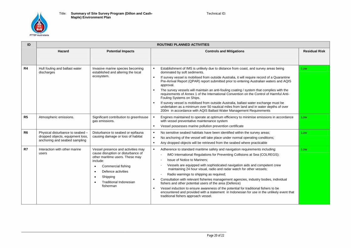
ID ROUTINE/ PLANNED ACTIVITIES
Hazard
Potential Impacts
Controls and Mitigations
Residual Risk
R4 Hull fouling and ballast water discharges
Invasive marine species becoming established and altering the local ecosystem.
Establishment of IMS is unlikely due to distance from coast, and survey areas being dominated by soft sediments.
If survey vessel is mobilised from outside Australia, it will require record of a Quarantine Pre-Arrival Report (QPAR) report submitted prior to entering Australian waters and AQIS approval.
The survey vessels will maintain an anti-fouling coating / system that complies with the requirements of Annex 1 of the International Convention on the Control of Harmful Anti-Fouling Systems on Ships.
If survey vessel is mobilised from outside Australia, ballast water exchange must be undertaken as a minimum over 50 nautical miles from land and in water depths of over 200m in accordance with AQIS Ballast Water Management Requirements
Low
R5 Atmospheric emissions. Significant contribution to greenhouse gas emissions.
Engines maintained to operate at optimum efficiency to minimise emissions in accordance with vessel preventative maintenance system
Vessel possesses marine pollution prevention certificate
Low
R6 Physical disturbance to seabed – dropped objects, equipment loss, anchoring and seabed sampling
Disturbance to seabed or epifauna causing damage or loss of habitat
No sensitive seabed habitats have been identified within the survey areas; No anchoring of the vessel will take place under normal operating conditions; Any dropped objects will be retrieved from the seabed where practicable
Low
R7 Interaction with other marine users
Vessel presence and activities may cause disruption or disturbance of other maritime users. These may include: • Commercial fishing • Defence activities • Shipping • Traditional Indonesian
fisherman
Adherence to standard maritime safety and navigation requirements including: - IMO International Regulations for Preventing Collisions at Sea (COLREGS); - Issue of Notice to Mariners; - Vessels are equipped with sophisticated navigation aids and competent crew
maintaining 24 hour visual, radio and radar watch for other vessels; - Radio warnings to shipping as required;
Consultation with relevant fisheries management agencies, industry bodies, individual fishers and other potential users of the area (Defence)
Vessel induction to ensure awareness of the potential for traditional fishers to be encountered and provided with a statement in Indonesian for use in the unlikely event that traditional fishers approach vessel.
Low
Title: Summary of Site Survey Program (Dillon and Cash-Maple) Environment Plan
Technical ID:
Page 21 of 22
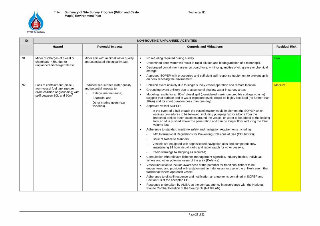
ID NON-ROUTINE/ UNPLANNED ACTIVITIES
Hazard
Potential Impacts
Controls and Mitigations
Residual Risk
N1 Minor discharges of diesel or chemicals <80L due to unplanned discharge/release
Minor spill with minimal water quality and associated biological impact
No refueling required during survey Unconfined deep water will result in rapid dilution and biodegradation of a minor spill. Designated containment areas on board for any minor quantities of oil, grease or chemical
storage. Approved SOPEP with procedures and sufficient spill response equipment to prevent spills
on deck reaching the environment.
Low
N2 Loss of containment (diesel) from vessel fuel tank rupture (from collision or grounding) with spill between 80L and 80m3
Reduced sea-surface water quality and potential impacts to: - Pelagic marine fauna; - Seabirds; and - Other marine users (e.g.
fisheries).
Collision event unlikely due to single survey vessel operation and remote location Grounding event unlikely due to absence of shallow water in survey areas Modeling results for an 80m3 diesel spill (considered maximum credible spillage volume)
suggest that surface and in water exposure levels would be highly localised (no further than 16km) and for short duration (less than one day).
Approved vessel SOPEP: - In the event of a hull breach the vessel master would implement the SOPEP which
outlines procedures to be followed, including pumping hydrocarbons from the breached tank to other locations around the vessel, or water to be added to the leaking tank so oil is pushed above the penetration and can no longer flow, reducing the total volume lost.
Adherence to standard maritime safety and navigation requirements including: - IMO International Regulations for Preventing Collisions at Sea (COLREGS); - Issue of Notice to Mariners; - Vessels are equipped with sophisticated navigation aids and competent crew
maintaining 24 hour visual, radio and radar watch for other vessels; - Radio warnings to shipping as required;
Consultation with relevant fisheries management agencies, industry bodies, individual fishers and other potential users of the area (Defence)
Vessel induction to include awareness of the potential for traditional fishers to be encountered and provided with a statement in Indonesian for use in the unlikely event that traditional fishers approach vessel
Adherence to oil spill response and notification arrangements contained in SOPEP and Section 9.3 of the accepted EP.
Response undertaken by AMSA as the combat agency in accordance with the National Plan to Combat Pollution of the Sea by Oil (NATPLAN)
Medium
Title: Summary of Site Survey Program (Dillon and Cash-Maple) Environment Plan
Technical ID:
Page 22 of 22
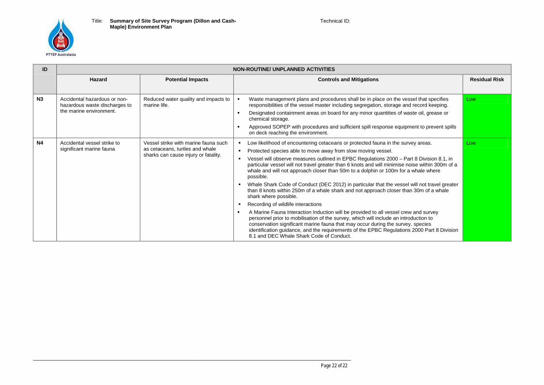
ID NON-ROUTINE/ UNPLANNED ACTIVITIES
Hazard
Potential Impacts
Controls and Mitigations
Residual Risk
N3 Accidental hazardous or non-hazardous waste discharges to the marine environment.
Reduced water quality and impacts to marine life.
Waste management plans and procedures shall be in place on the vessel that specifies responsibilities of the vessel master including segregation, storage and record keeping.
Designated containment areas on board for any minor quantities of waste oil, grease or chemical storage.
Approved SOPEP with procedures and sufficient spill response equipment to prevent spills on deck reaching the environment.
Low
N4 Accidental vessel strike to significant marine fauna
Vessel strike with marine fauna such as cetaceans, turtles and whale sharks can cause injury or fatality.
Low likelihood of encountering cetaceans or protected fauna in the survey areas. Protected species able to move away from slow moving vessel. Vessel will observe measures outlined in EPBC Regulations 2000 – Part 8 Division 8.1, in
particular vessel will not travel greater than 6 knots and will minimise noise within 300m of a whale and will not approach closer than 50m to a dolphin or 100m for a whale where possible.
Whale Shark Code of Conduct (DEC 2012) in particular that the vessel will not travel greater than 8 knots within 250m of a whale shark and not approach closer than 30m of a whale shark where possible.
Recording of wildlife interactions A Marine Fauna Interaction Induction will be provided to all vessel crew and survey
personnel prior to mobilisation of the survey, which will include an introduction to conservation significant marine fauna that may occur during the survey, species identification guidance, and the requirements of the EPBC Regulations 2000 Part 8 Division 8.1 and DEC Whale Shark Code of Conduct.
Low