title : how geography affects the economy: st....
TRANSCRIPT

Social Studies Lesson Plan Template 1
Title: How Geography Affects the Economy: St. Lucia
Lesson Author: Tommy George, Gina Rumbolo Key Words: geography, volcanoes, mountains, hurricanes, bananas, St. Lucia, United States, island, location Grade Level: 11 Time Allotted: 45 minutes
Rationale/ Purpose (so what?)
Because it is important to develop an understanding of other cultures, the way people live and sustain themselves, students will come to understand the impact that the environment and the geographical features of a place have on the inhabitants.
Key Concept(s) include definition:
1. Absolute location- The location of a point on the Earth's surface that can be expressed by a grid reference such as latitude and longitude.
2. Relative location- A place that is described by landmarks, time, direction or distance from one place to another and may associate a particular place with another.
3. Longitude- Angular distance on the earth's surface, measured east or west from the prime meridian at Greenwich, England, to the meridian passing through a position, expressed in degrees (or hours), minutes, and seconds.
4. Latitude- The angular distance north or south of the earth's equator, measured in degrees along a meridian, as on a map or globe.
5. Topographic map- A map that shows the physical features of a place; 6. Map- A picture of a place that is usually drawn to scale on a flat surface.

Social Studies Lesson Plan Template 2
NCSS Standard(s) SOL Information (As written in the Virginia SOL “Curriculum Framework” for the grade level)
NCSS Theme (s) with indicators:
1. Production, Distribution, and Consumption a. challenge learners to apply economic concepts and reasoning when evaluating historical and contemporary
social developments and issues; b. enable learners to explain how the scarcity of productive resources (human, capital, technological, and
natural) requires the development of economic systems to make decisions about how goods and services are to be produced and distributed;
c. help learners analyze the role that supply and demand, prices, incentives, and profits play in determining what is produced and distributed in a competitive market system;
d. provide opportunities for learners to assess how values and beliefs influence economic decisions in different societies;
2. People, Places, and Environment a. enable learners to construct, use and refine mental maps of locales, regions, and the world that
demonstrate their understanding of relative location, direction, size, and shape; b. challenge learners to examine, interpret, and analyze the interactions of human beings and their physical
environments; c. provide learners with opportunities to observe and analyze social and economic effects of environmental
changes and crises; d. teach students to estimate and calculate distance, scale, area, and density, and to distinguish spatial
distribution patterns; e. help learners to locate, distinguish, and describe the relationships among varying regional and global
patterns of geographic phenomena such as landforms, climate, and natural resources;
SOL: WG.1b The student will use maps, globes, photographs, and pictures in order to develop and refine his or her mental maps of world regions.

Social Studies Lesson Plan Template 3
WG.3b The student will apply the concept of a region by explaining how regional landscapes reflect characteristics of their inhabitants. WG.7a The student will identify natural, human, and capital resources and explain their significance by showing patterns of economic activity and land use.
Essential Knowledge (minimum for SOL Resource Guide)
• Comparing sketch maps to maps in atlases or other resources
• Describing the location of places in terms of reference points (e.g.,
the equator, prime meridian)
• Describing the location of places in terms of geographic features
and land forms (e.g., west of the Mississippi River, north of the Gulf
of Mexico) • Describing the location of places in terms of the human
characteristics of a place (e.g., languages, types of housing, dress,
recreation, customs and traditions)
Identify Environmental Impacts on Humans:
• Settlement patterns • Agricultural activity
• Transportation patterns
Essential Skills (minimum for SOL Resource Guide)
• Locate places on maps and globes.
• Interpret maps and globes.
• Draw maps from memory.
• Evaluate information. • Interpret the idea, concepts, or events expressed by pictures, or
other graphic media.
• Explain cause and effect relationships.
Guiding Question(s): How do geographic size, location and features of a place influence the economic activity of a place? Assessment Tool(s): -Oral Response -Student written notes/response -T-chart -Writing prompt

Social Studies Lesson Plan Template 4
Background: How does this lesson fit into a unit of study? Looking backwards, looking forwards
Backwards: Geographical features: Water, Climate and Vegetation Forward: How technology can be used to modify and adapt to the environment.
Lesson Objective(s): Students will be able to:
1. Use primary source images to compare their mental mind map of a place to what it really looks like.
2. Identify and explain how geographical features can determine the way a society’s economy functions.
3. Compare the geographical features of one place to another.
Historical Source(s): (include copies in materials
section) Additional Materials/Resources: (include
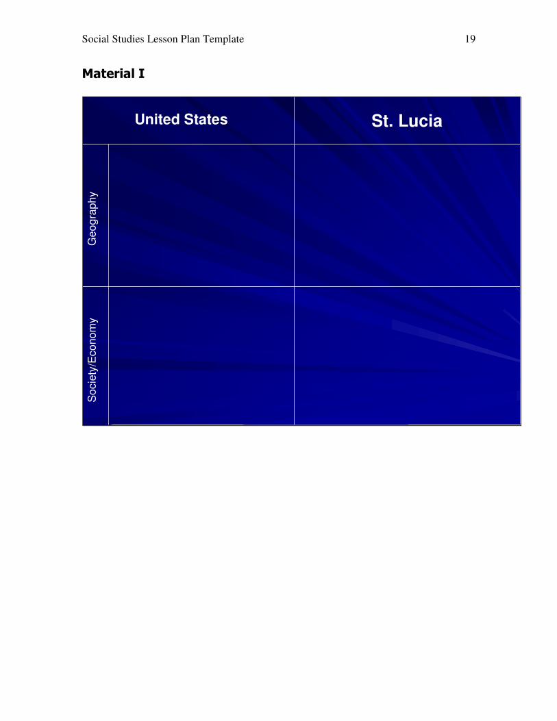
copies in materials section) -Photos of St. Lucia (Material B-G) -Banana article (Material H)
-Photos handout (Material A) -T-Chart (Material I)

Social Studies Lesson Plan Template 5
Procedure/Process:
JUST DO IT! The “Hook”: (A high-interest activity that introduces new content with connections to students’ prior knowledge. Between 1-5 minutes (Could also introduce the days guiding question)
Obj # See
above.
Processing Activity and Procedure -include directions, question frames, assignment detail to be given to
students (these should all be made into explicit materials (e.g. see material A), and time estimates
Check for Evidence of Understanding -Either Formal or Informal-
(Checks Essential Knowledge and Skills)
Just do it.
Students should answer the following questions: Have you ever heard of St. Lucia? Where is it? What does it look like? What do you picture when you think of St. Lucia? On a piece of paper draw a rough map of St. Lucia in relation to other countries. (5 minutes) After working individually, students should be called on to give their responses. (2 minutes) **Please note, students should write the answers to the just do it activity as they will be collected at the end of the grading period. They will be asked to share what they have written orally. For students with no existing mental map, guiding questions may include: Does it look like the terrain of the United States? Do they have any important landforms, like mountains or volcanoes? Is it an island or is it landlocked? Is it warm or cold there? Does it have distinct seasons? Is it tropical?
Oral student response and written response (once “just do its” are collected).

Social Studies Lesson Plan Template 6
Transition: Now that you have a vision in your head of what St. Lucia is like, let’s look at some images to see how your mental image compares.
Objective #1
Images of St. Lucia will be shown so that students can compare their mental mind map of a place to what it really looks like. Each picture has a question frame that should be asked by the teacher. Students will be given handouts with the pictures on them. Students should write on the handout what is discussed about the pictures. See Material A for student handout. See Material B-G for pictures and question frames. (7-10 minutes)
Oral student response and written notes that students make about the pictures.
Transition: Now that you have seen some of the geographical features of St. Lucia, let’s look at a news article about their biggest crop and see if we can figure out how those features have affected their economy.
Objective #2
Students will read the article “Banana dispute feeds fear, anger toward U.S.” in order to identify and explain how geographical features can affect a society. See Material H for the article. Students should write their findings in the notes section of their notebook. After students have read the article and written down their findings, their responses will be discussed as a class. (15 minutes)
Oral response and student notes.
Transition: Using your previous knowledge about the geography of the United States, let’s make a T-chart to compare St. Lucia to the United States.
Objective #3
Students should use their previous knowledge of the United States and what they have just learned about St. Lucia to make a T-Chart to compare the geographical features of each place and characteristics of the economies of each place. See Material I for chart. (10 minutes)
T-Chart

Social Studies Lesson Plan Template 7
Closure/Writing Prompt: Divide a piece of paper into two sections. One section will be for the United States, the other section will be for St. Lucia. Using your T-Chart and any of your other notes from class, please draw a picture for both the United States and St. Lucia that depicts its geological features and features of their economies. Under each picture please explain what you have drawn. Finally, answer the following question: Given what you have discovered about the way the terrain affects the life of the inhabitants in St. Lucia and what you know about the United States, do you think it is fair for the WTO to support the U.S. by authorizing tariffs on goods from the European Union (which St. Lucia sells their bananas to)?

Social Studies Lesson Plan Template 8
Material A: Student Handout Slide 1
___________________________________
___________________________________
___________________________________
___________________________________
___________________________________
___________________________________
___________________________________
Slide 2
___________________________________
___________________________________
___________________________________
___________________________________
___________________________________
___________________________________
___________________________________
Slide 3
___________________________________
___________________________________
___________________________________
___________________________________
___________________________________
___________________________________
___________________________________

Social Studies Lesson Plan Template 9
Slide 4
___________________________________
___________________________________
___________________________________
___________________________________
___________________________________
___________________________________
___________________________________
Slide 5
___________________________________
___________________________________
___________________________________
___________________________________
___________________________________
___________________________________
___________________________________
Slide 6
___________________________________
___________________________________
___________________________________
___________________________________
___________________________________
___________________________________
___________________________________

Social Studies Lesson Plan Template 10
Material B
Question Frame:
1. What do you see? 2. Where is the Caribbean in relation to the United States, Central and
South America? 3. Within the Caribbean where is St. Lucia? 4. Where did you place St. Lucia in our mental mind map? 5. Looking at the map, can you determine St. Lucia’s absolute location?
(Measured by longitude and latitude) 6. Look at the size of St. Lucia. How does it compare to the United
States?

Social Studies Lesson Plan Template 11
Material C:
Question Frame:
1. What do you see? 2. What kind of map is this? 3. What does this map tell you about the terrain of St. Lucia? 4. Can you tell what some of its geographical features are? If so, what
are they?

Social Studies Lesson Plan Template 12
Material D
Question Frame:
1. What do you see? 2. What kind of vegetation do you see? 3. Does this look like an area that could produce crops? 4. Do you see any crops in the picture? 5. What can you conclude about the climate in this region?
Material E

Social Studies Lesson Plan Template 13
Question Frame?
1. What do you see? 2. Describe the land. 3. Where are man-made structures/buildings? 4. Do they have roads? If yes, where are they located? Do they have a
lot or a little? 5. Given that structures are taking up the flat land that does exist,
where would they plant crops?

Social Studies Lesson Plan Template 14
Material F
Question Frame: 1. What do you see? 2. What stands out in this picture? 3. Once again, where are people located? 4. Do you see roads? 5. How do you think what is displayed, or not displayed in this picture
might affect their economy?

Social Studies Lesson Plan Template 15
Material G
Question Frame: 1. What do you see? 2. What geographical feature do you think this picture is of? 3. What do you know about this specific geographical feature? 4. How might this geographical feature affect the economy or society of
the people of St. Lucia?
Social Studies Lesson Plan Template 16
Material H
Banana dispute feeds fear, anger
toward U.S. by Dan Perry The Associated Press
CASTRIES, St. Lucia - It's the start of the rainy season in the mountainous, fertile island of St. Lucia - a time when Ellis Rupert Gajadhar and fellow banana farmers should be happily looking forward to peak harvesting and profit. But it's a season of uncertainty now on Caribbean islands heavily dependent on their bananas - and a time of deep bitterness toward the United States, which won a key battle last week in its war against trade preferences that keep Europe buying the yellow fruit. For America, the issue is U.S. firms' stake in the global economy. For Europe, it's partly a moral debt to people they enslaved. And for islanders, it's a humbling quest for a place in the sun. On a farm just south of Castries, Gajadhar's eyes sparkle as he speaks of bananas. "Bananas are my life, and bananas are the region's lifeblood," says the owner of 16 acres. Gajadhar, 52, believes Caribbean bananas are the best - "a sweeter, better-tasting fruit" than those grown by U.S. giants such as Chiquita Brands and Dole Food in Latin America. The problems
But he admits some problems. Substandard storage and transport make quality inconsistent. Absence of irrigation suppresses yield much of the year. And hurricanes make supply forecasts unreliable. Seattle Times: Banana dispute feeds fear, anger toward U.S. http://seattletimes.nwsource.com/news/nation-world/html98/bana_19990412.html (1 of 4) [5/2/2001 2:06:10 PM]
Bananas were introduced by British colonizers and developed after independence because they grow year-round and boast the high yield-to-land ratio important to tiny territories. Bananas - and, more recently, tourism - are credited for somewhat improved living standards. But the per-capita income on many islands remains low - about $3,000 a year in St. Lucia - and their economies are dangerously dependent on one crop. In the Windward Islands, the southern half of the eastern Caribbean

Social Studies Lesson Plan Template 17
chain, about a third of the labor force works in bananas, providing 35 percent of export earnings. Bananas are also key to larger Caribbean countries, such as Jamaica. The vast majority of the region's crop - a mere 1 percent of the world's production - goes to Europe. There, it has long been protected and now accounts for almost a tenth of the EU's banana imports. A scheme established in 1993 gives preference in licensing to those who import bananas from former colonies in the Caribbean, Africa and the Pacific, and imposes tariffs on bananas from elsewhere. This is seen by many in the Caribbean as an obligation to former colonies populated by descendants of Africans the Europeans enslaved. In what's being called the "banana war," American officials have charged that the preferences are unfair to U.S. companies that grow bananas in Central America, cost consumers billions, and are illegal and inefficient. "It's an ideal world (the Caribbean) had over many years, and everybody would want to live in that kind of thing," said D. Brent Hardt, chief of the political and economic section at the U.S. Embassy in Barbados. "But it has stymied growth in what had been a rapidly growing market." Hardt insisted the United States was not opposed to the idea of preferences but to the way they are implemented, and that there are ways to "both provide protection and meet (World Trade Organization) rules." Such fine points seem lost in the Caribbean. What happened
The WTO decision Tuesday to support the U.S. claims and authorize $191 million of punitive U.S. tariffs on EU goods sparked gloom and fears of imminent European capitulation. Seattle Times: Banana dispute feeds fear, anger toward U.S. http://seattletimes.nwsource.com/news/nation-world/html98/bana_19990412.html (2 of 4) [5/2/2001 2:06:10 PM]
"If anything or anyone has to be sacrificed as a result of this ruling, the banana producing islands . . . in the Caribbean will," The Voice newspaper said in an editorial. The ruling "ought to send shivers down the spine of banana growers." People on the street heartily agreed. "Everyone is cursing the United States," said Moses Eugene, 32. "We need the banana money. When someone from down the street wants to

Social Studies Lesson Plan Template 18
buy your stuff and your neighbor interferes, it's not right." For many, it confirms that the United States has lost interest in the region because of its diminished strategic value in the post-Cold War world. U.S. aid levels to the English-speaking Caribbean are at a fraction of the former $200 million a year, they note. "These are friendly little countries to the U.S., and that the U.S. would want to jeopardize their economic backbone is unbelievable!" said Bernard Cornibert, head of Windward Islands Banana Development and Exporting. "If we do not have a regime that maintains access for our bananas in the EU, our banana industry would collapse," he said. "That means increasing unemployment, falling income and all the social and political problems." The drug question
He said some growers might turn to marijuana, or help the northbound transit of South American drugs. "We're being pushed to retaliate in this kind of disgusting manner." At a summit in Suriname last month, leaders angered by the U.S. challenge discussed suspending a 1997 treaty for Caribbean nations to cooperate in the U.S. war on drugs. Gajadhar is trying to come up with more constructive ideas. When his father started growing bananas, he remembers, "they would walk 3 miles to Castries with bunches on their heads." He has since seen the advent of truck delivery, protective foam packing for the bushels and fungicides. What the industry needs now is reliability - and that means finding the money for expensive containers to protect bananas on their voyage to Europe, and for irrigation to eliminate overdependence on the April-to-October rainy season. "The farmers have the ability to adjust because of the fact that there is no alternative to bananas here. We're going to produce bananas!" he said. "It's a question of survival."
Social Studies Lesson Plan Template 19
Material I
United States St. Lucia
Ge
og
raph
yS
ocie
ty/E
co
no
my

Social Studies Lesson Plan Template 20
Teacher Notes (Reflections/clarifications/explanations): Geography is very complex subject because absolutely everything is interrelated. Therefore, it is important for the teacher to have a thorough understanding of the material. Some students may pick up on more connections than the teacher intended for this one lesson. However, because you can’t cover everything at once, it is important for the teacher to focus their attention to specific ideas and concepts.