title: green spaces in the context of spatial urban
TRANSCRIPT

Title: Green Spaces in the Context of Spatial Urban Development: Interrogating the Case of Federal Capital
City of Nigeria
Authors: Olukoya Obafemi A.P1 (M.Arch) and Olukoya Oluwaseun. M2 (M.Arch)
Affiliations: 1 Doctoral Researcher, Faculty of Architecture, Civil Engineering and Urban Planning. IGS:
Heritage Studies PhD Program. Brandenburg Technical University, Cottbus-Senftenberg, Germany
2 Principal Architect, Olukoya Obafemi Consult (OOC), Area 1, Garki, Abuja, Nigeria.
Email: [email protected]

Abstract
Generally, green spaces play an irreducible role in the sustainability of urban areas. Such roles include
social, economic, cultural and environmental aspects. Thus, preserving urban green spaces has stimulated
diverse positions in both researches and international debates overtime. In spite of the abundance of
positions however, preserving green spaces in growing cities of developing countries with changing
urbanization conditions has not been given comparative attention. Against this background, this paper
makes a case of the Federal Capital City (FCC) of Nigeria as a typical city in its development phase in a
developing countries with surging urbanization condition. In this case, over the last few years, there has
been an alarming disappearance of designated green spaces in the city, against what was planned for in the
Master Plan in 1979. In spite of the enactment of land use policies, there is nevertheless a consistent
disappearance of green spaces in this city. As a point of departure therefore, this research argues that there
is an urgent need for scientific study which investigates and document the status quo of green space in the
city using the Master Plan as a reference point. To achieve this aim, gathering and interpretation of data
which lead to the arguments and descriptions are presented methodologically based on a triangulated
research approach. Conclusively, this paper posit that demonstrating the impacts of rapid spatial
development on green spaces in developing cities such as the FCC, Abuja can be a cautionary case for the
future of cities in developing countries.
Keywords: Urban Green Space; Spatial Development; FCC, Abuja; Developing Countries; Nigeria

1. Introduction
Generally, cities are the physical reality of the grip of man upon nature (Le Corbusier, 1929). They are
human-made artefacts and are often opposed to nature (MacHarg 1971). Thus, in the history of urban
development, urban planners have tried to create urban spaces that also incorporate elements from nature
(Ibid). Nevertheless, green space is under permanent pressure today due to a complex of reasons which
revolves around spatial developments in urban areas (Rodenburg, et al, 2001). In this regard, most developed
countries have focused on the pursuit of more rational schemes on environmental management and land use
planning to achieve sustainable urban land use and protect green spaces. In developing countries however,
the reality is different. This is due to the changing socio-economic situation, growing population, surging
urbanization rates and lack of political will to implement land use policies, just to mention a few.
Against this backdrop, this research makes a case of the Federal Capital City (FCC) of Nigeria as a typical
example of city in its development phase in Africa’s most populous country. Today, the urbanization rate
in Abuja is at an alarming rate of 8.32% per annum and this makes it the fastest growing city in Africa
(Myers, 2011). The initial Master Plan of the city developed by the International Planning Associates (IPA)
in 1979 (IPA, 1979) provided for a foreseen population of 3 million people (Ibid; Jubril, 2006) and provided
for such green spaces to sustain such population. However, today, its day-time population often reaches up
to 7 million (Iro, 2007; Abubakar, 2014). As a result of this explosive and unforeseen population influx, the
city has been confronted with a complex of challenges. Such challenges includes, acute shortage of housing
(Abdullahi, 2010; Umoh, 2012), the multiplying informal settlements (Amba, 2010; Jibril, 2006), water
scarcity (Abubakar, 2012), dilapidated sewer systems (Ilesanmi, 2006; Ojo, 2011) and traffic congestion
(Benna Associates, 2009).
To respond to the mentioned challenges in the context of spatial development, it has been accompanied by
an alarming disappearance of designated green spaces in the city, against what was planned for in the Master
Plan in 1979. In spite of the enactment of a continuum of land use policies such as the 1978 Land Use Act,
the 1992 Urban Development Policy, the 1992 Urban Regional Planning Act, the 2002 Housing and Urban
Development (Alabi & Akinbode, 2010; Olajuyigbe & Rotawa, 2011), there is nevertheless a consistent
disappearance of green spaces in this city as demonstrated in figure 1.
Figure 1. Showing an example of the current utilization of green space in Abuja (Jibril, 2006)

As a point of departure therefore, this research argues that there is an urgent need for scientific study which
investigates and document the status quo with the Master Plan of the capital city as a reference point. To
drive the arguments for the aim, this research adopts and adapts the widely used framework “Pressure–
State–Response” (PSR) of the Organization for Economic Co-operation and Development (OECD 1993,
1998). This framework is based on three kinds of indicator: pressure, state and response indicators (figure
2).
Figure 2. PSR (pressure–state–response) framework (Source: OECD 1993). The focus of this paper is on
the encircled portion.
According to figure 2 and in the context of this paper, the following are the definitions of the mentioned
indicators are adapted from Boyd, 1997; van Delft, 1997 and Rotmans, 1997. Pressure indicators refers to
the forces behind the development (e.g. construction of infrastructure) and utilization of urban green.
However, they can also represent social, economic and ecological driving forces stimulating the
development and utilization of urban green. State indicators are defined as the current state-of-the- art of
urban green space and the quality in the case. Lastly, Response indicators refers to the human intervention
in response to the loss of green spaces. This represents the policy decisions on the part of the responsible
authorities
Based on this approach, the focus of this research is therefore on the State indicators. Today, there are a
very scant literature which interrogates the state of the green spaces in this city. Therefore, this paper posit
that investigating and documenting the impacts of rapid infrastructural development on green spaces in
developing cities such as the FCC, Abuja can be a cautionary case for the future of cities in developing
countries. Furthermore, this is an obligatory ingredient for achieving the evidence based argument for
developing a plural framework which brings quest for spatial development within cities and preservation of
green spaces into a common framework. Against this background, this paper is organized as follows. In the
next section, the concept of green spaces and its roles in urban areas is briefly discussed. The subsequent
sections focuses on the Abuja city case study. The historical and current situation are adumbrated. The other
sections focuses on the methodology, discussion, recommendations and conclusion.
2. Green Space in Urban Areas: A Review
Urban green spaces can come in numerous distinctive shapes and sizes. They can incorporate expansive
territories like parks, fairways, zoos, the distance down to empty parts, medians on side boulevards and
indeed grower hanging off of a window in a rear way (Kuti, 2015). By definition, a green space is a land
that consists predominantly of unsealed, permeable, soft surfaces such as soil, grass, shrubs and trees. This

emphasis is the predominant character due to the fact that green spaces may include buildings and hard
surfaced areas. Therefore, it is the umbrella term for all such areas whether or not they are publicly accessible
or privately managed (Dunnett et al., 2002). Generally, the term green space is often used interchangeably
with open space. However, open space is an area of undeveloped land which is normally held as
horticultural, recreational or characteristic area utilization. In any case, under recreational land use, green
spaces also exists which are changed over to open spaces in numerous urban areas (Valk & Dijk, 2009).
Furthermore, green spaces could be public or private in urban areas and could be easily differentiated as
those directly (e.g. active or passive recreation) or indirectly (e.g. positive influence on the urban
environment) available for the users (Tuzin et al, 2002). Thus, green spaces represent an important
environmental component of urban areas that covers all open spaces primarily covered by vegetation which
are directly or indirectly available for use (URGE Team, 2004).
As a concept, however, the conception of green space in urban areas is not new in research. It has been
thoroughly discussed from classical research to contemporary times. It has taken diverse forms over time as
regards the related conceptions within the urban context. In early nineteenth (19th) century of the mid-
European bourgeois, the creation of urban green spaces was regarded as a candid trend within their culture.
Initially during the early times, such green spaces were to exhibit the grandeur as well as the supremacy of
any existing constitutional system (Poëte, 1913). As an appellation however, green space is a more recent
term and its inception can be traced to the urban nature conservation movement and the European
contemplating the planning of green space which began in United Kingdom (Dunnett et al., 2002). In recent
literature, urban green spaces has been worked out in similar definitions and assembled as indicated by the
capacities they perform in three domains which include economic, social and environmental (Tuzin et al.,
2002; Dunnett et al., 2002; URGE Team, 2004; Alberti, 2008; DeWolf, 2009).
2.1 Classification of Urban Green Spaces
Generally, green spaces are classified according to the primary uses which includes recreational purposes,
exploratory, social and also natural green space (Brinkyte, 2013). They can include large areas like parks,
golf courses, zoos and also vacant lots, medians on side streets, and even planters hanging off of a window
and in road lanes (DeWolf, 2009). Green space may also be informally created through communities using
derelict urban spaces. Community gardens constitute one of such forms of informal green space (Kellett and
Rofe, 2009). However, Dunnett et al. (2002) produced a typology of urban green space comprising of four
main classifications, namely; amenity green space, functional green space, semi-natural habitats and linear
green space. These illustrations have been represented respectively in the Table 1 below.
Table 1. Typology of urban green space according to Dunnet et al. (2002)
Typology of Urban Green Space
Primary classification Secondary Classification Associative Uses
Amenity Green Space
Recreation Green Space
Parks and Gardens
Informal Recreation Areas
Outdoor Sports Areas
Play Areas
Incidental Green Space
Housing Green Space
Other Incidental Space
Private Green Space
Domestic Gardens
Productive Green Space
Remnant Farmland
City Farms
Allotments

Functional Green Space Burial Grounds
Cemeteries
Churchyards
Institutional Grounds
School Grounds [including school
farms and growing areas]
Other Institutional Grounds
Semi-natural Habitats
Wetland
Open/Running Water
Marsh, Fen
Woodland
Deciduous woodland
Coniferous woodland
Mixed woodland
Other Habitats
Moor/Heath
Grassland
Disturbed Ground
Linear Green Space River and Canal Banks
Transport Corridors (road, rail cycle
ways and walking routes)
Other linear features (e.g. cliffs)
2.2. Roles of Green Spaces in Urban Areas
Generally, green spaces play an irreducible role in the sustainability of urban areas. Such roles include
social, economic and environmental aspects. Thus, the quality of life in urban environment depends very
much upon the quality of the green spaces (Goode 1990; Hough 1984). Quality of life in this context is
defined as a combination of life conditions and satisfaction (Felce and Perry, 1995). Each of the benefits of
urban green space are briefly discussed as follows
2.2.1 The Environmental Benefits
Urban green spaces plays an important environmental role in maintaining the ecosystem services ranging
from regulation of urban climate to the maintenance of biodiversity. Generally, urban areas usually have
differences in solar input, rainfall pattern and temperature in comparison to rural areas (Heidt &Neef, 2008).
Also, urban green spaces can reduce air pollutants with the ability to trap dust and smoke particles through
vegetation (Bolund & Sven, 1999). Furthermore, urban green spaces performs preservation functions. It
preserves the cultural and natural local heritage due to the fact that it provides habitat for a diversity of urban
wildlife (such as birds and insects). Urban green spaces also conserves the diversity of urban resources such
as trees and plants (Rodenburg, et al 2001).
2.2.2. The Economic Benefits
Generally, green spaces provides cooling effect and help to lower air temperatures through the provision of
shade and evapotranspire. Therefore, one of the ways to reduce cost of cooling buildings is through the
usage of vegetation and it has been increasingly recognized as a cost effective reason for increasing green
space and tree planting in temperate climate cities (Heidt &Neef, 2008).
2.2.3. Social Benefits
Urban green spaces serve as a near resource for relaxation; provide emotional warmth. For example, in
Mexico City, up to three million visitors are drawn to the centrally located Chapultepec Park and they enjoy
a wide variety of activities (Sorensen, et al, 1997). Generally, green spaces are assumed to be beautiful and
therefore have an aesthetic appeal. Thus, the availability of urban green spaces in a city are argued to
increases the quality of life, due to the beauty quality they possess which enables people to be conscious of
space and time (Rodenburg, et al 2001).
Therefore, green spaces assume a key role in the efforts towards enhancing the urban environment and
improving the quality of urban life and play a key role for performing sustainable ideals However, despite
the overwhelming advantages of urban green spaces, they are under permanent pressure today due to a
complex of reasons (Rodenburg, et al, 2001). Urban areas everywhere throughout the world are confronting
genuine difficulties as an issue of increasing population, increment in their spatial development and
environmental change. In this regard, preserving green spaces in cities has stimulated diverse positions in
research and dominated international debates from classical times to contemporary era. In spite of the
abundance of debates and positions however, preserving green spaces in developing cities, especially in
developing countries with changing economic and urbanization conditions has not been given comparative
attention in research
3. The Abuja Case
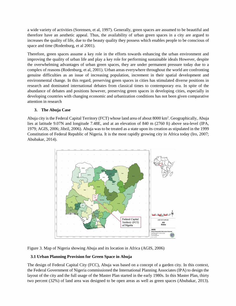
Abuja city is the Federal Capital Territory (FCT) whose land area of about 8000 km2. Geographically, Abuja
lies at latitude 9.07N and longitude 7.48E, and at an elevation of 840 m (2760 ft) above sea-level (IPA,
1979; AGIS, 2006; Jibril, 2006). Abuja was to be treated as a state upon its creation as stipulated in the 1999
Constitution of Federal Republic of Nigeria. It is the most rapidly growing city in Africa today (Iro, 2007;
Abubakar, 2014).
Figure 3. Map of Nigeria showing Abuja and its location in Africa (AGIS, 2006)
3.1 Urban Planning Provision for Green Space in Abuja
The design of Federal Capital City (FCC), Abuja was based on a concept of a garden city. In this context,
the Federal Government of Nigeria commissioned the International Planning Associates (IPA) to design the
layout of the city and the full usage of the Master Plan started in the early 1980s. In this Master Plan, thirty
two percent (32%) of land area was designed to be open areas as well as green spaces (Abubakar, 2013).
The area designated for various functional spaces and for the entire greenery was twenty five percent (25%)
while seven percent (7%) was for parks (IPA, 1979). The Master Plan of Abuja turned into the directing
guideline for the organized advancement of the city and has been being used in the most recent 30 years
(IPA, 1979).
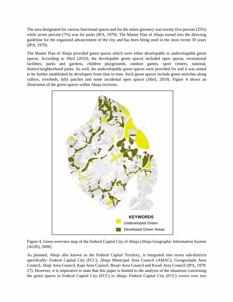
The Master Plan of Abuja provided green spaces which were either developable or undevelopable green
spaces. According to Jibril (2010), the developable green spaces included open spaces, recreational
facilities, parks and gardens, children playgrounds, outdoor games, sport centers, national,
district/neighborhood parks. As well, the undevelopable green spaces were provided for and it was aimed
to be further established by developers from time to time. Such green spaces include green stretches along
valleys, riverbeds, hilly patches and some incidental open spaces (Jibril, 2010). Figure 4 shows an
illustration of the green spaces within Abuja environs.
Figure 4. Green overview map of the Federal Capital City of Abuja (Abuja Geographic Information System
(AGIS), 2006)
As planned, Abuja also known as the Federal Capital Territory, is integrated into seven sub-districts
specifically: Federal Capital City (FCC), Abuja Municipal Area Council (AMAC), Gwagwalada Area
Council, Abaji Area Council, Kuje Area Council, Bwari Area Council and Kwali Area Council (IPA, 1979:
27). However, it is imperative to state that this paper is limited to the analysis of the situations concerning
the green spaces in Federal Capital City (FCC) in Abuja. Federal Capital City (FCC) covers over two
Undeveloped Green Areas Developed Green Areas
KEYWORDS

hundred and fifty kilometres (250km) of the eight thousand kilometres (8,000km) of Abuja, Nigeria (IPA,
1979; AGIS, 2006; Jibril, 2006). It is situated in the north-eastern part of FCT. The configuration of the
Federal Capital City of Abuja was given in a development of four-phases; with the city separated into
divisions which themselves were subdivided into districts and can been in Figure 5.
Figure 5. Map of the Federal Capital Territory (FCT), showing the location of the Federal Capital City
(FCC) in Abuja (AGIS, 2006)
Sadly, most of the designated green spaces within Abuja have been replaced with residential and commercial
developments. A case study in Figure 1 depicts the green territory in Abuja by Ministers' Hill within the
Maitama District that has been eradicated by bulldozers in arrangement for private developments.
4. Methodology
The research is organized into two broad categories namely; the theoretical part and the empirical part. Tools
to be used ranged from text-based content analysis to field inspection. The arguments in the theoretical part
of the research is driven by secondary data collected via critical review of relevant literature while the
empirical section is based on field work via case study action. Methods are selected flexibly according to
the particular research question and objective to be attained. In some cases, several methods would be
applied to the same set of data for the benefit of reconfirmation of the results. To tailor the research method
and provide the necessarily elaborations on the aims, this research is driven by the following research
question
What is the state of the green space in Abuja today?
What are the typologies of green spaces?
What are the ecological zones which characterizes this green spaces?
What is the distribution of the available green spaces today?
What are the accessibility to the available green space?
Phase I
Phase II
Phase III
Phase IV

What are the factors responsible for the decline of green space?
Therefore, to provide the necessary answer to this questions, the methodological steps are organized in three
distinctive stages of evolution, towards broadening on the sources of data and confirmation of data with
multiple source. All three stages included the highlighting and categorizing of arguments used to affirm the
state of the green space in the city layout. The stages are as follows;
4.1 Stage 1: Use of Geographical Information System (GIS)
The data source for stage one is mainly through the use of Geographical Information System (GIS). Meaning
that the satellite map of Abuja was searched and emphasis was placed on the available green spaces within
the layout. The available green spaces were identified using the Master Plan as the threshold and subsequent
captured as JPEG images. The captured images were architecturally drawn out using Autodesk AutoCAD.
Several images of maps were produced during this process and were invigorated against the available green
space in the layout in 1979.
Concerning data analysis, two different approaches were undertaken – direct and indirect – distinguished
by method, but aiming at the same result (Silva & Roders, 2012). The method used for the direct approach
consisted in establishing a correlation between the existing green spaces today and what was provided for
in the Master Plan in 1979. The method used for the indirect approach followed the process of coding, all
images extracted from the GIS were organized and coded in accordance to the typology of green spaces
identified in the Master plan.
4.2 Stage 2: Relation between Document and GIS Map
The data sources for stage 2 were mainly documentary and oral. The purpose was to verify the relation
between the provision of GIS and the provision of the Master Plan. Two types of documents were analyzed
in this phase. One document was an AutoCAD file of the Master Plan and the other is a PDF document of
the original Master Plan. Furthermore, the experiences of the involved stakeholders (policy implementation)
in the various governmental parastatals were also incorporated. To cope with the difficulties on gaining
access to all the relevant documentation, an informal open ended discussion was held with the staffs of
Abuja Geographic Information System (AGIS). Among the various office in charge of implementation, the
AGIS was selected due to the fact that they are the outfit responsible for the computerization of the cadastral
system and the restoration of the land uses to the original master plan (Akingbade,et al, 2012).
A comparison was also made by the direct and indirect approach. The results of the informal interview
conducted with the stakeholders was invigorated against the maps that were already drawn out using
AutoCAD. For a better illustration and faster perception of the results, a specific color was attributed to
areas on the layout where the green spaces have already disappeared.
4.3 Stage 3: Relation between GIS Map, Document and Site Survey
The data sources for this stage were mostly through site visit. This was done to verify the correlation between
the images produced via the GIS, Master Plan and the empirical situation. Site survey was conducted using
the layout provided by the Master Plan to locate the designated green spaces. The locations of visit was
limited the case which is the districts a within the Phase I of the Federal Capital City (FCC), Abuja which
is the main case of the research. This phase was conducted in the company of surveyors, although, access
were not granted to a few green spaces such as the IBB Golf Course which required membership for access
to be granted. This served as one of the limitations of the site survey. One of the advantages from this step
is that when comparing documents, it provides immediate distinction between the existing situation and
what was provided for in the Master Plan in 1979.

Conclusively, the interpretation of data which lead to the arguments and descriptions presented is
methodologically based on a triangulated research approach. This means that different research approaches
were utilized to analyze the set of data gathered. Also, analysis was achieved by interpretive coding through
the maps produces and classification of the valid data to generate interpretations and verdicts from the
collected data.
5. Results
After following the methodological steps, are the result of the iterative steps. Five maps were produced and
they are described as follows;
5.1 The Status Quo of Green Space in Abuja
The locations of the districts and the existing green spaces within the Phase I of the Federal Capital City
(FCC), Abuja are being illustrated in Figure 6. The description for Figure 6 can be seen in the Table 2 below.
Taking into cognisance the description of green spaces in urban landscape according to Dunnett et al. (2002),
the existing green spaces in Abuja have been placed under the classifications
Figure 6. Map indicating the status quo of green space by districts in Abuja and the Master Plan
Undeveloped Green Areas
Developed Green Areas
KEYWORDS
1980 2016

Table 2. Description of the existing Green spaces in Phase I of Federal Capital City (FCC), Abuja

5.2 Typology of the available Green Space
As stated in the literature review, there are four main typologies of urban green spaces according to Dunnett
et al. (2002). As it is adopted in this research, the typology in the Abuja case include the Amenity Green
space, the Functional Green space and the Semi-natural habitat and have been identified alongside the Table
2 above in Figure 7 depicting the Abuja green spaces However, three typologies were identified from the
reproduced map of the Abuja green spaces of the Phase I of Federal Capital City (FCC). Under the identified
typologies of Abuja green spaces are the categories in which each green space falls into. The categories
include the Institutional grounds, Recreation Green spaces, Productive Green spaces and the Wetlands.
Subsequently, the categories of the green spaces have been graphically represented in Table 2.
Figure 7. The map of typology of green spaces in phase I of Federal Capital City (FCC), Abuja according
to Dunnett et al. (2002)
5.3 Ecological Zones of the Green Spaces
Figure 8 is an illustration of the natural existing components that make up the vegetation in Abuja environs.
This Savannah zone comprises the combination of woodlands, scattered trees, wet flush vegetation and
grasslands. However, traces of rainforest also exist within the green spaces to fit into the natural environment
usually to house various biodiversity. The Savannah zone encompasses all the existing green spaces within
the Phase I of the Federal Capital City of Abuja being identified in the maps and various representations.
In the case of the existing wildlife and domestic animals, some green spaces have created havens to house
such. The havens add an extra feature to the Abuja green spaces in which they occur. There is an encouraged
preservation and conservation towards biodiversity through the green spaces. Wildlife exists not only for
tourism and recreational purposes but also as part of the natural environment that should regarded as natural
KEY
1 National Arboretum
2 Secretariat Park
3 Durban Street
Neighbourhood Park
4 National Children Park
and zoo
5 IBB Golf Course
6 Maitama
Neighbourhood Park
7 Millennium Park
8 MFCT Fishery
9 Bulet Park
10 Glaval Park
11 Abuja Park
12 Recreational Park
13 Abuja Zoological Park
14 J. Berger
Neighbourhood Park
15 Zone 6
Neighbourhood Park
16 Wuse Rock Park
17 Oroni Garden
18 Giwa Park
19 Afro-asia Garden
20 Abuja Neighbourhood
Park
21 City Park
22 Lobito Crescent Park
23 Shagari Park

heritages in any environment they are. Wildlife and domestic animals are being preserved within National
Children's Park & Zoo (4) and Abuja Zoological Park (13).
Figure 8. The map of natural features within green spaces in phase I of Federal Capital City (FCC), Abuja
5.4 Neighborhood Access to Green Space
As palpable in Figure 9, the circled portion (around the Abuja green spaces) represents the distances in six
hundred metres (600m) / fifteen minutes (15 mins) walk of the green spaces to the immediate built
environment and its surroundings with reference to the accessible green space standard developed by Bristol
City Council (2008) The vast portion in the map which is represented in red (according to the legend) is the
part of the layout without obvious green space.
KEY
1 National Arboretum
2 Secretariat Park
3 Durban Street
Neighbourhood Park
4 National Children Park
and zoo
5 IBB Golf Course
6 Maitama
Neighbourhood Park
7 Millennium Park
8 MFCT Fishery
9 Bulet Park
10 Glaval Park
11 Abuja Park
12 Recreational Park
13 Abuja Zoological Park
14 J. Berger
Neighbourhood Park
15 Zone 6
Neighbourhood Park
16 Wuse Rock Park
17 Oroni Garden
18 Giwa Park
19 Afro-asia Garden
20 Abuja Neighbourhood
Park
21 City Park
22 Lobito Crescent Park
23 Shagari Park
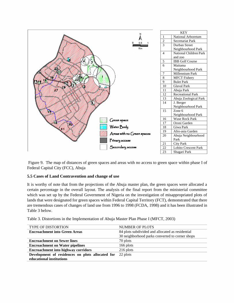
Figure 9. The map of distances of green spaces and areas with no access to green space within phase I of
Federal Capital City (FCC), Abuja
5.5 Cases of Land Contravention and change of use
It is worthy of note that from the projections of the Abuja master plan, the green spaces were allocated a
certain percentage in the overall layout. The analysis of the final report from the ministerial committee
which was set up by the Federal Government of Nigeria on the investigation of misappropriated plots of
lands that were designated for green spaces within Federal Capital Territory (FCT), demonstrated that there
are tremendous cases of changes of land use from 1996 to 1998 (FCDA, 1998) and it has been illustrated in
Table 3 below.
Table 3. Distortions in the Implementation of Abuja Master Plan Phase I (MFCT, 2003)
TYPE OF DISTORTION NUMBER OF PLOTS
Encroachment into Green Areas 84 plots subdivided and allocated as residential
30 neighborhood parks converted to corner shops
Encroachment on Sewer lines 70 plots
Encroachment on Water pipelines 166 plots
Encroachment into highway corridors 216 plots
Development of residences on plots allocated for
educational institutions
22 plots
KEY
1 National Arboretum
2 Secretariat Park
3 Durban Street
Neighbourhood Park
4 National Children Park
and zoo
5 IBB Golf Course
6 Maitama
Neighbourhood Park
7 Millennium Park
8 MFCT Fishery
9 Bulet Park
10 Glaval Park
11 Abuja Park
12 Recreational Park
13 Abuja Zoological Park
14 J. Berger
Neighbourhood Park
15 Zone 6
Neighbourhood Park
16 Wuse Rock Park
17 Oroni Garden
18 Giwa Park
19 Afro-asia Garden
20 Abuja Neighbourhood
Park
21 City Park
22 Lobito Crescent Park
23 Shagari Park

Table 4. Cases of Land Use Contraventions (FCDA, 1998)
District Cases of Contraventions Conversion of land allocated to open
spaces and green areas over the
period in hectares
Central Area 4 20.72
Garki 8 42.49
Asokoro 7 28.87
Wuse 11 89.12
Maitama 21 86.85
Total 51 268.05
6. Discussion
Abuja is Africa’s fastest growing city. The urbanization rate in Abuja is at an alarming rate of 8.32% per
annum. Africa (Myers, 2011). To respond to the allied challenges of the unforeseen congestion, there has
been spatial developments in the city over the years. This spatial development has interfered with the initial
provision of green spaces in the city. Not only has the incessant development interfered, the green spaces
left in the city cannot support the available population today.
As demonstrated in the result in figure 6, there has been disappearance of more than 70% of the designated
and undesignated green space. Although, the categorization in the Master Plan is according to developed
and undeveloped green spaces, in any case, both are almost gone. Table 2 shows the existing green space,
the sizes and the distance from each neighborhood in each case. In cases where the designated spaces such
as national parks are still available, the sizes have reduced considerably due to the need for spatial
development. Also, the imminent results are the degradation of the existing natural habitat as well as the
entire ecological systems within it as demonstrated in figure 8. Furthermore, according to figure 9, almost
all the neighborhoods lack decent access to green spaces due to the change of use of the green space to
satisfy the quest for spatial development.
The other prominent problem is from the illegal land administering and land-use misappropriations involved
in the developments of the city as well as informal settlements being enacted within the Federal Capital City
(FCC) of Abuja. Table 3 and 4 illustrate cases of changes of land use and contraventions. This include
change of use of designated green space to satisfy personal quests by authorities. The table further
demonstrated the number of case and the hectare of land which were converted in each case. The rapid
increment in the Abuja population and unrestrained misuse of the natural resources result in greater peril to
the urban sustainability of the city.
Lastly, the informal open ended interview conducted with the staffer of the Abuja Geographical Information
Systems (AGIS) also buttressed the fact that disappearance of the green space is due to change of land use
so as to address the challenges caused by the unforeseen urban population. In other to fully implement the
proposed Abuja Master Plan, the Federal Government of Nigeria established agencies in various service
levels to facilitate a comprehensive development to the new capital city. At the helms of the affairs of all
jurisdictions in Abuja are the Federal Capital Territory Administration (FCTA) and a FCT minister to
oversee the entire welfare of Abuja, the Federal Capital Territory (FCT) of Nigeria. Also, there was an
enactment of a continuum of land use policies such as the 1978 Land Use Act, the 1992 Urban Development
Policy, the 1992 Urban Regional Planning Act, the 2002 Housing and Urban Development (Alabi &
Akinbode, 2010; Olajuyigbe & Rotawa, 2011), there is nevertheless a consistent disappearance of green
spaces in this city. It was therefore gather that, these are policies which are slated to protect this green space,
however, there is lack of political will to implement this policies. As usual in third world countries, there
are always an ontological rupture between policies on paper and its implementation and this due to the
overarching effects of corruption.
7. Recommendation
With the emphasized discussion noted, some recommendations have been derived. These recommendations
include:
1. Reorientation of natural environment and the benefits of green cities
There is need for public re-orientation about the benefits of green spaces in urban layouts. Programmes can
be established by the land administrators to sensitize the Abuja residents as way of awareness for the
consciousness of environmental impacts of nature and green spaces. The sensitization can also be included
in the curriculum of schools other institutions. Also, awareness campaigns can be done to brief the
inhabitants on the processes of the land use acts and the remunerations of environmentally composed cities.
It is of clarity that the outcomes of this research could be beneficial for impending developers and civic
workforces when generating strategies and planning resolutions of green spaces for a sustainable city.
2. Effective administration by government and land agencies
A better effective and efficient development of green spaces can be achieved by applying good governance
to the land administration sectors of Abuja in which the Federal government is being accountable to all the
inhabitants of Abuja. Also, the stakeholders are inclusive as they play roles in the various representations
of the policies to be implemented. The advancement and preservation of the green spaces all depend on the
government authorities and land administration parastatals.
3. Delegation of Responsibilities
The Federal Capital Development Authority (FCDA) participated in the initial projection of the proposed
master plan for Abuja and they should be entrusted with autonomy to implement the responsibilities of the
development of the natural environment. Not all the agencies should have this privilege as they should work
under the control of FCDA not as independent bodies.
In addition, the FCDA should set up periodicals to review the implementation and policies that affect the
land use purposes of the Abuja master plan. Their computerized information should be more accessible and
more inclusive so that individuals can review the land uses from time to time. Also, a detailed land use
review noting all the expansions existing within Abuja should be studied and reviewed on basis. In the quest
to institute sustainability of the environment and preservation of green spaces, the authorities should retain
a database of tangible and prospective green spaces classified according to landscape and environmental
principles.
8. Conclusion
Due to the changing socio-economic situations, cities in developing countries are faced with the challenge
of managing unforeseen populations and congestions. Therefore, among others, preservation of urban green
space would determine how developing cities respond to the many allied challenges of increasing
populations in years to come. In this vein, this research investigated the overview of green spaces in Abuja,
the Federal Capital City of Nigeria which is the fastest growing city in Africa. To respond to the surging
urbanization, there has been an unsustainable encroachment on designated green space in the urban area.
Despite the enactment of policies and creation of governmental parastatals, there is nonetheless a consistent
decline of the green spaces. Through the methodology used in documenting the status quo of the green
spaces in this research, it was realized the available green spaces are no longer evenly distributed in the city
and the areas covered by the existing green spaces are not enough to accommodate the population of

residents in Abuja. These occurrences have been represented in the various reproduced maps of the green
spaces within Phase I of Federal Capital City (FCC).
Therefore, the implementations of policies which guides land use in Abuja has procured prime significance.
The implementation of policies and planning for the new for the surging population would be a contributory
solution in this specific case. Furthermore, at this phase of the development of the capital city, the restoration
of the green spaces is still possible if the status quo is adequately understood. Research over the years have
demonstrated how green spaces could be artificially created, therefore, it is incumbent of the planning
authorities to research on best practices and implement them in the Abuja case.
In conclusion, this research demonstrate the disappearance of green spaces in Abuja as a cautionary case for
future cities in developing countries. Similar cities in its development phase in developing countries should
adequately plan for unforeseen population growth and effectively demonstrate the impact of loss of green
space to the public at the planning phase of each city.
Acknowledgement
We acknowledge the contributions of Asst. Prof. Dr. Payam Mahasti of the department of Architecture,
Cyprus International University, Haspolat, North Cyprus.
Reference
Abubakar, I. R. (2014). Abuja city profile. Cities, 41, 81-91.
Abdullahi, B. C. & AbdAziz, W. N. Z. (2010). Nigeria’s Housing Policy and Public Private Partnership
(PPP) Strategy: Reflections in Achieving Home Ownership for Low-Income Group in Abuja, Nigeria.
Presented at urban dynamics & housing change-crossing into the 2nd decade of the 3rd millennium, 4–7
July, Istanbul.
Abubakar, I. R. (2012) Household Coping Strategies with Unsatisfactory Urban Services in Abuja, Nigeria.
Presented at Association of American Geographers 2012 annual meeting, February 24–28, New York, USA.
Abubakar, I. R. & Doan, P. L. (2010). New towns in Africa: Modernity and/or decentralization? Presented
at the African studies association 53rd annual meetings, November 18–21, San Francisco, USA.
Abuja Geographic Information Systems (2013). Land administration: Fresh land application procedure.
http://www.agis.fct.gov.ng/land_admin.html Retrieved December 05, 2014
Akingbade, A., Navarra, D., Zevenbergen, J., & Georgiadou, Y. (2012). The impact of electronic land
administration on urban housing development: The case study of the Federal Capital Territory of Nigeria.
Habitat International, 36(2), 324–332.
Alabi M. O., & Akinbode A., (2010). Towards Effective Physical Planning in Local Governments in
Nigeria. Environmental Research Journal, 4(2), 173-176.
Alberti M., (2008). Advances in Urban Ecology: Integrating Humans and Ecological Processes in Urban
Ecosystems. Springer US, New York, United States of America. ISBN: 978-0-387-75509-0.
Amba, K. (2010). The Need for Popular Participation in Abuja: A Nigerian Story of Informal Settlements.
Journal of Place Management and Development, 3(2), 149–159.
Benna Associates (2009). Abuja master plan review: Socio-economic surveys, analysis and
recommendations – Final report. Technical report submitted to FCDA, Abuja.

Bolund P. & H. Sven, (1999). Ecological Services in Urban Areas. Ecological Economics, Vol. 29, pp. 293-
301.
Boyd, D. (1997) ‘Why a Course on Indicators for Sustainable Development?’, in International Institute for
the Urban Environment (ed.), Advanced Study Course on Indicators for Sustainable Urban Development
(Delft, Netherlands: Nivo).
Brinkyte E., (2013). Urban Green Space System: A Case Study of Siauliai City. Siauliai University,
Lithuania, 1(10): 30-41.
DeWolf T., (2009). Do Green Spaces Have an Effect on Social Capital within Communities?
http://westsidebinghamton.org.Retrieved July 22, 2015
Dunnett N., Swanwick C. and Woolley H., (2002). Improving Urban Parks, Play Areas and Green Spaces.
Dept. for Transport, Local Government and the Regions, London. pp. 8 (4) and pp. 16 (40).
Felce D. and Perry J., (1995). Quality of Life: Its Definition and Measurement. Research in Developmental
Disabilities. DOI: 10.1016/0891-4222(94)00028-8.
Goede, E., C.A. Rodenburg, E.S. van Leeuwen and P. Nijkamp (2001) Development of Urban Green Spaces
to Improve the Quality of Live in Cities and Urban Regions: Economic Criteria (EVK4-CT-2000-00022, 7;
Amsterdam: Economic and Social Institute).
Heidt V. and M. Neef, “Benefits of Urban Space for Improving Urban Climate,” Ecology, Planning and
Man-agement of Urban Forests: International Perspective, 2008.
Hough, M. (1984) City Form and Natural Processes (London: Croom Helm)
IPA (International Planning Associates) (1979). The Master Plan for Abuja, the New Federal Capital of
Nigeria. FCDA, Abuja: Nigeria.
Ilesanmi, I. J. (2006). Pre-feasibility Assessment of Onsite and Decentralised Sanitation Systems for New
Satellite Settlements in Abuja, Nigeria. PhD dissertation, Hamburg University of Technology.
Iro, I. (2007). Demographic pressure and the application of GIS in land reforms: The case of restoration of
Abuja Master Plan and sanitization of cadastral and land registry. In Proceedings of map middle east
conference on GIS development, Dubai, UAE.
Jibril, I. U. (2006). Resettlement Issues, Squatter Settlements and the Problems of Land Administration in
Abuja, Nigeria’s Federal Capital. In 5th International federation of surveyors regional conference, March
8–11, Accra, Ghana.
Kellet, J. and Rofe, M. (2009), Creating Active Communities: How Can Open and Public Spaces in Urban
and Suburban Environments Support Active Living? (Adelaide: Institute for Sustainable Systems and
Technologies, university of South Australia).
Kuti, Oluwaseun, M. (2015). The Role of Green Spaces in Urban Areas: A Case Study of Federal Capital
City, Abuja, Nigeria. Department of Architecture, Cyprus International University. Unpublished Master
Thesis
Le Corbusier, (1929). The City of Tomorrow and its Planning. John Rodker, London.
MacHarg, I.L. (1971) Design with Nature (Garden City, NY: Doubleday).
Myers, G. A. (2011). African cities: Alternative visions of urban theory and practice. London: Zed Books

OECD (Organisation for Economic Co-operation and Development) (1993) OECD Core Set of Indicators
for Environmental Performance Reviews: A Synthesis Report by the Group on the State of the Environment
(Environment Monograph 83; Paris: OECD).
—— (1998) Towards Sustainable Development: Environmental Indicators (Paris: OECD). Priemus, H.
(1999) ‘Sustainable Cities: How to Realise an Ecological Breakthrough: A Dutch Approach’, International
Planning Studies 4.2: 213-36.
Ojo, V. O. (2011). Customer satisfaction: A framework for assessing the service quality of urban water
service providers in Abuja. Doctoral thesis, School of Civil and Building Engineering, Loughborough
University.
Olajuyigbe A. E., & Rotawa, O. O., (2011). Optimizing Physical Planning in the Developing Countries- A
case Study of Ondo State, Nigeria. Sustainable Development, 4(4), 202-209.
Poëte M., (1913). La promenade à Paris au XVII esiècle. L’art de se promener – Les lieux de promenade
dans la ville et aux environs (The Paris promenade of the 17th century. The art of walking – The place of
the walk in the city and its surroundings). A. Colin, Paris, (in French).
Rodenburg, C., Baycan-Levent, T., Van Leeuwen, E., & Nijkamp, P. (2001). Urban Economic Indicators
for Green Development in Cities. Greener Management International, (36).
Rotmans, J. (1997) ‘Indicators for Sustainable Development’, in J. Rotmans and B. de Vries (eds.),
Perspectives on Global Change: The TARGETS Approach (Cambridge, UK: Cambridge University Press):
187-204.
Silva, A., & Roders, A. (2012). Cultural heritage management and heritage (impact) assessments. In
Proceedings of the Joint CIB W070, W092 & TG International Conference: Delivering Value to the
Community (pp. 23-25).
Sorensen M, J. Smit, V. Barzetti and J. Williams, “Good Practices for Urban Greening,” Inter-American
Develop-ment Bank, 1997. http://www.iadb.org/sds/doc/ENV109KKeipiE.pdf. Retreived on July 07, 2015
Tuzin, B., Leeuwen, E., Rodenburg C., & Peter, N. (2002). Paper presented at the 38th International
Planning Congress on “The Pulsar Effect” Planning with Peaks, Glifada, Athens, 21-26 September 2002.
Umoh, N. (2012). Exploring the enabling approach to housing through the Abuja Mass Housing Scheme.
Doctoral dissertation, Massachusetts Institute of Technology.
Urban Green Environment (URGE) Team, (2004). Making Greener Cities: A Practical Guide. Leipzig-
Halle: UFZ Centre for Environmental Research. Retrieved from http://www.urge-project.org.No. 8/2004.
Valk A. and van Dijk T., (2009). Regional Planning for Open Space. Routledge publishers; London and
New York. Pp. 249-278.
van Delft, Y. (1997) ‘An Introduction to Indicators and Monitoring’, in International Institute for the Urban
Environment (ed.), Advanced Study Course on Indicators for Sustainable Urban Development (Delft,
Netherlands: Nivo).
