tick advisory woods park park history -...
TRANSCRIPT

Fair Haven Rd.
SEA BRIGHT
MONMOUTHBEACH
AT
LA
NT
IC O
CE
AN
SANDY HOOKB AY
ATLANTIC HIGHLANDS
MOUNT MITCHILLSCENIC OVERLOOK
TWIN LIGHTS HISTORIC SITE
LITTLE SILVER
Navesin
k
River
Shrew
sbury
Rive
r
GATEWAY NATIONAL RECREATION AREA
SANDY HOOK
POPAMORA POINT
FAIR
HAVEN
RUMSON
HUBER
WOODS PARK
Bay Av.
Mid
d letown- Lincroft R
d . Swim
ming R
iver Rd. Tinto n Av. Wayside Rd.
Green G
rove Middle Rd. Main
St
Laurel Av. Van Scho ick R
d. Dwigh t Rd. N
C
hurc
h St
.
P
ortla
nd
EARL
E
R.
R.
&
HIG
HW
AY
Bro
wns D
ock Rd.
Navesin
k
Av.
Bingham Av.
Bellevue Av.
Buena Vista Av.
Hance Rd.
Broad St.
Bergen Pl.
Patterson
Branch Av.
White
Sycam
ore
Av. Sycamore Av.
Little
Silver
Will
ow
D
r.
Port-
Au- Peck C
omanc
he
Dr.
Bath Av.
O
cean
Av.
Oce
an
Oce
an
A
v.
Patt
e n A
v.
Wesley Beach
520
520
520
HARTSHORNE WOODS PARK
Navesin
k
River
Rd.
Seven Bridges Rd.
Cooper Rd.
C
oop
er
Rd.
Bamm Hollow Rd. Oak Hill Rd. Chapel
H
ill
R
d.
Rumson
Rd.
Rumso
n Rd.
Front St.
River
Rd.
River
Rd.
Hardi ng
Rd. Ridge Rd.
R
idge
Rd.
West
36
36
Rd.Av.
Oceanport Av.
Rd.
Rect
or P
l.
Shrewsbury A
v.
Bay Av. Center Av.
Ocean Blvd.
35
Linden Av. W
ater
W
atch
Av
.
East Rd. Sleepy H
ollow
Leon
ard
Av.
520
M I D D L E T O W N
8A
11
11
8A
Locu
stA
v.
Hubbard
Rd.
W
ilson
Av.
West
Pinkney
Rd.
Locust Point Rd.
H artshorne Rd.
Hos
ford
Av.
Rd.
Front
St .
HIGHLANDS
New
M
onm
ou
th Rd.
Leonardville Rd.
Bro
adw
ay A
v.
K
King s Highway East
Monmouth Av.
U.S. NAVALWEAPONS STATION EARLE
BAYSHORE WATERFRONT PARK
Portland R
d.
GARDEN STATE PA
RK
WAY
G
AR
DEN
S
TAT
E
P
AR
KW
AY
Av.
D
Hartshorne Woods Park Locust (Middletown), NJ
732-872-0336 or 2670
N
HENRY HUDSON
TRAIL
Gra
nd A
v.
Highland Av.
Hillside Av.
1st A
v.
Pt. Rd.
S. RIVER PARK
Fishing Anglers can cast for striped bass, fluke and flounder in the Navesink River from Black Fish Cove (a steep, 0.7 mile walk from the Rocky Point parking lot). All anglers age 16 and up must register online (for free) to fish in marine and fresh tidal waters of NJ. Visit www.saltwaterregistry.nj.gov.
Welcome to Hartshorne Woods ParkThis hilly, forested 794-acre site overlooks the Navesink River & features prominently in area history. Known for its challenging trail system and scenic views, Hartshorne Woods is a popular park for area hikers, bicyclists and outdoor enthusiasts.
Park HistoryThis park is named after Richard Hartshorne, an English Quaker from London who settled here in 1669 and acquired more than 2,300 acres of land. By the early 1800s, some was sold to private individuals and the U.S. government, but large portions remained in his family. The Park System acquired the first 660 acres of this park in 1974. The U.S. government conveyed additional land in 1984, and subsequent purchases – including the 44-acre Claypit Creek section in 2005 – brought the park to its current size.
Navesink Military Reservation at Rocky PointThis 224-acre park area was a desirable coastal defense site because of its elevation, and has hosted a number of military installations through the years. It was listed on the National Register of Historic Places in 2015.
During the WWII era, heavy artillery batteries or bunkers were built on this site and remain to this day. These concrete and earth structures – considered bomb-proof at the time – protected the guns whose purpose was to defend the New York Harbor. When the rise of strategic air power and nuclear weapons ended reliance on artillery guns for coastal defense, the site served as a missile defense and command center (Highlands Army Air Defense Site [HAADS]). Cold War Era radar equipment and structures have all been removed.
Park HoursHartshorne Woods Park is open every day of the year from 7 a.m. to dusk, free of charge.
Tick AdvisoryTo avoid contact with the ticks that may cause illness: stay away from tall grass and shrubby areas, walk in the center of trails, wear light-colored clothes, tuck long pants into socks, and check yourself for ticks during and after each visit to the parks. Read more about preventing tick bites at www.cdc.gov/ticks.
From Garden State Parkway Exit 117: (North or South-bound) Follow Rt. 36 (East) for 12.6 miles. Turn right (before the bridge) onto Portland Rd. Follow for 0.7 miles to Rocky Point entrance.From State Hwy 35: Navesink River Rd. east for 4.7 miles (joins 8A north). Follow bend and turn right onto Locust Ave., cross bridge. At next intersection (stone church) turn right onto Navesink Ave. (8B-East). Follow for 0.8 miles (past Buttermilk Valley entrance). Turn right onto Rt. 36 and follow for 1.2 miles. Turn right (before the bridge) onto Portland Rd., follow for 0.7 miles to Rocky Point entrance.From Sea Bright/southern shore points: Follow Route 36/Ocean Ave. north. Cross the Highlands bridge. Make first right and follow U-turn signs (under bridge). Come up the hill turn left onto Portland Rd. Follow for 0.7 miles to Rocky Point entrance.
Monmouth County Board of Chosen FreeholdersBoard of Recreation Commissioners G17463-8/17 www.MonmouthCountyParks.com
Monmouth County Park System
HartshorneWoodsParkMiddletown, NJ
Battery Lewis
Protect Your ParksThe Park System preserves and manages natural and cultural resources on more than17,000 acres of land in Monmouth County.Protecting water quality, eliminating invasiveplant species, and promoting healthy wildlifehabitats are just a few objectives.
Please help protect the park by leaving flowers, plants, animals, and other features as you found them; adhering to posted park rules; using designated containers for trash, recyclables and pet waste; and keeping your pets leashed. Alcoholic beverages are not permitted.
An overabundance of white-tailed deer in and around this park is threatening the health of native plant and animal species. Portions of Hartshorne Woods Park maybe open for deer hunting during all or some of the State-regulated hunting season. All hunting areas are clearly posted. Call 732-842-4000 ext.4237 or visit www.MonmouthCountyParks.com for more information.
Black Fish Cove
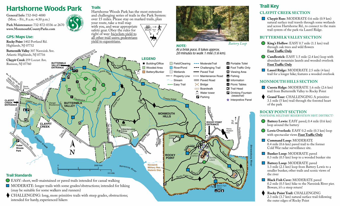
TrailsHartshorne Woods Park has the most extensive and challenging series of trails in the Park System: over 15 miles. Please stay on marked trails, plan your route, take a trail map with you, and wear appropriate safety gear. Obey the rules for right of way: bicyclists yield to all other trail users; pedestrians yield to equestrians.
LEGEND
Navesink River
Hartshorne Rd.
Locu
st A
ve. (
8A)
N
avesink Ave. (8A)
To Route 36
Huber WoodsPark
Gra
nd To
ur
Terrace
Clay
Ct.
Tan Vat Rd.
To GSP/Rt 36
Valley Dr - (8A)
Grand Tour
P ortland Rd.
Henry Hudson H.S.
NavesinkMilitary Res.Historic Dist.
ToRt. 36
BUTTERMILKVALLEY
MONMOUTH HILLS
BUTTERMILKVALLEYENTRANCE
CLAYPITCREEKENTRANCE
Cuesta Ridge
CommandLoop
Gran
d Tou
r
Laur
el R
idge
Kings Hollow
Laurel Ridge
Grand Tour
Battery Lewis
Laurel Ridge
Candlestick
Pier Black FishCove
MaintenanceArea
CLAYPITCREEK
Claypit Creek
Stone Church
Grand Tour
Cabin
Indian
Hartshorne Rd.
Cuesta Ridge
Shrew
sbury River
Ranger Residences
Battery Loop
Locust Point Rd. (8A)
Battery 219
ModerateTrailChallenging TrailPaved TrailMaintenance RoadPaved RoadBridgeBoardwalkWater towerParking
Field/ClearingRiver/PondWetlandsProperty LineStreamEasy Trail
Building/OfficeWooded AreaBattery/Bunker
Wigwam Rd.
Rocky Point Trail
Lewis Overlook
Rocky Point Trail
Bunk
er Loop
ROCKYPOINT
Candlestick
ROCKY POINTENTRANCE
Batte ry Loop
Portable ToiletFoot Traffic OnlyViewing AreaFishingInformationPicnic TablesTrail HeadDrinking Fountain (seasonal)Interpretive PanelClaypit Run
2000 feet
0
0
0.5 mile
Trail KeyCLAYPIT CREEK SECTION
Claypit Run: MODERATE 0.6 mile (0.9 km) natural surface trail travels through some wetlands and across Hartshorne Rd., to connect to the main trail system of the park via Laurel Ridge.
BUTTERMILK VALLEY SECTIONKing’s Hollow: EASY 0.7 mile (1.1 km) trail through oak trees and wild flowers Foot Traffic OnlyCandlestick: EASY 1.5 mile (2.4 km) loop with abundant mountain laurels and wooded overlook Foot Traffic OnlyLaurel Ridge: MODERATE 2.5 mile (4 km) trail for a longer hike; features a wooded overlook
MONMOUTH HILLS SECTIONCuesta Ridge: MODERATE 1.6 mile (2.6 km) trail from Buttermilk Valley to Rocky PointGrand Tour: CHALLENGING A primitive 3.1 mile (5 km) trail through the forested heart of the park
ROCKY POINT SECTION(NAVESINK MILITARY RESERVATION HIST. DISTRICT)
Battery Lewis: EASY paved, 0.4 mile (0.6 km) loop around the batteryLewis Overlook: EASY 0.2 mile (0.3 km) loop with spectacular views Foot Traffic OnlyCommand Loop: MODERATE 0.4 mile (0.6 km) paved trail to the former Cold War radar surveillance site.Bunker Loop: MODERATE paved 0.3 mile (0.5 km) loop to a wooded bunker siteBattery Loop: MODERATE paved 1.3 mile (2.1 km) loop from Battery Lewis to a smaller bunker, other trails and scenic views of the riverBlack Fish Cove: MODERATE paved 0.2 mile (0.5 km) hike to the Navesink River pier. Beware, it’s a steep return!Rocky Point Trail: CHALLENGING 2.3 mile (3.7 km) natural surface trail following the outer edges of Rocky Point
Hartshorne Woods ParkGeneral Info: 732-842-4000(Mon. - Fri., 8 a.m.-4:30 p.m.)
Park Maintenance: 732-872-0336 or 2670www.MonmouthCountyParks.com
GPS/Maps Use:Rocky Point 1402 Portland Rd. Highlands, NJ 07732Buttermilk Valley 307 Navesink Ave.Atlantic Highlands, NJ 07716Claypit Creek 259 Locust Ave. Rumson, NJ 07760
Trail Standards EASY: short, well-maintained or paved trails intended for casual walkingMODERATE: longer trails with some grades/obstructions; intended for hiking (may be suitable for some walkers and runners)CHALLENGING: long, more primitive trails with steep grades, obstructions; intended for hardy, experienced hikers
YIELD TO
Battery LoopNOTE: At a brisk pace, it takes approx. 20 minutes to walk 1 mile (1.6 km).