through the seasons, find your adventure a sky full of
TRANSCRIPT
summer/fall 2015
Find Your AdventureOn the Guadalupe Ridge TrailA Sky Full of Wonder and a Mosaic of Biodiversity
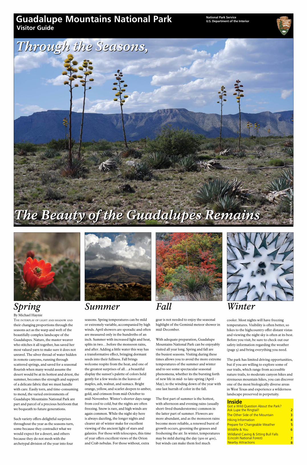
By Michael HaynieThe inTerplay of lighT and shadow and their changing proportions through the seasons act as the warp and weft of the beautifully complex landscape of the Guadalupes. Nature, the master weaver who stitches it all together, has saved her most valued yarn to make sure it does not unravel. The silver thread of water hidden in remote canyons, running through scattered springs, and saved for a seasonal flourish when many would assume the desert would be at its hottest and driest, the summer, becomes the strength and support of a delicate fabric that we must handle with care. Easily torn, and time-consuming to mend, the varied environments of Guadalupe Mountains National Park are part and parcel of a precious heirloom that we bequeath to future generations.
Such variety offers delightful surprises throughout the year as the seasons turn, some because they contradict what we would expect for a desert, and others because they do not mesh with the archetypal division of the year into four
seasons. Spring temperatures can be mild or extremely variable, accompanied by high winds. April showers are sporadic and often are measured only in the hundreths of an inch. Summer with increased light and heat, splits in two…before the monsoon rains, and after. Adding a little water this way has a transformative effect, bringing dormant seeds into their fullness. Fall brings welcome respite from the heat, and one of the greatest surprises of all…a beautiful display the sunset’s palette of colors held gently for a few weeks in the leaves of maples, ash, walnut, and sumacs. Bright orange, yellow, and scarlet deepen to amber, gold, and crimson from mid-October to mid-November. Winter’s shorter days range from cool to cold, but the nights are often freezing. Snow is rare, and high winds are again common. While the night sky here is always dazzling, the longer nights and clearer air of winter make for excellent viewing of the ancient light of stars and galaxies. For those with telescopes, this time of year offers excellent views of the Orion and Crab nebulas. For those without, extra
gear is not needed to enjoy the seasonal highlight of the Geminid meteor shower in mid-December. With adequate preparation, Guadalupe Mountains National Park can be enjoyably visited all year long. Spring and fall are the busiest seasons. Visiting during these times allows you to avoid the more extreme temperatures of the summer and winter and to see some spectacular seasonal phenomena, whether its the bursting forth of new life in mid- to late-spring (April - May), to the winding down of the year with one last hurrah of color in the fall.
The first part of summer is the hottest, with afternoon and evening rains (usually short-lived thunderstorms) common in the latter part of summer. Flowers are more abundant, and as the monsoon rains become more reliable, a renewed burst of growth occurs, greening the grasses and freshening the air. In winter, temperatures may be mild during the day (50s or 40s), but winds can make them feel much
Spring Summer Fall Wintercooler. Most nights will have freezing temperatures. Visibility is often better, so hikes to the highcountry offer distant vistas and viewing the night sky is often at its best. Before you visit, be sure to check out our safety information regarding the weather (page 5) and bring everything you need. The park has limited driving opportunities, but if you are willing to explore some of our trails, which range from accessible nature trails, to moderate canyon hikes and strenuous mountain hikes, you can discover one of the most biologically diverse areas in West Texas and experience a wilderness landscape preserved in perpetuity.
Through the Seasons, Through the Seasons,
The Beauty of the Guadalupes RemainsThe Beauty of the Guadalupes Remains
InsideGot a Wild Question About the Park?Ask Lupe the Ringtail!
The Other Side of the Mountain
Prepare for Changeable WeatherWildlife & You
Hiking Information
Wildland Caving & Sitting Bull Falls(Lincoln National Forest)Nearby Attractions
23
56
4
78
NPS
Ph
oto
s/M
. Hay
nie
Visitor Guide
National Park Service U.S. Department of the InteriorGuadalupe Mountains National Park

Telephone andWeb Directory Guadalupe Mountains National Park400 Pine Canyon DriveSalt Flat, TX 79847915-828-3251 ext. 2124www.nps.gov/gumoFacebookwww.facebook.com/Guadalupe.Moun-tainsTwitter@GuadalupeMtnsNPInstagram guadalupemountainsnps
Food, Lodging, and CampingCarlsbad Chamber of Commerce575-887-6516www.carlsbadchamber.com
Van Horn Texas Visitors Bureau432-283-2682
Road ConditionsNew Mexico: 800-432-4269www.nmroads.comTexas: 800-452-9292 drivetexas.org
Emergency: Call 911
Guadalupe Mountains NPVisitor Center (Nature Trail)Coordinate System: Lat/LongDatum: WGS 1984Latitude: 31.89370° NLongitude: 104.82214° W
2 Visitor Guide
As a nonprofit education partner
of the National Park Service,
WNPA supports 71 national
park partners across the West,
developing products, services, and
programs that enrich the visitor
experience.
In partnership with the National
Park Service since 1938,
WNPA advances education,
interpretation, research, and
community engagement to ensure
national parks are increasingly
valued by all.
Have a wild question you want answered?
Ask Lupe!
Email [email protected]
and we’ll get your questions to
our park’s mascot asap.
Ask Lupe!
Lupe, When I arrived at the park my car said one time and my phone said another. The internet said sunset was at one time, but the sun set a whole hour earlier! What is happening?! Sincerely, Lost in the Twilight Zone
Dearest Lost in the Twilight Zone,
Well, let me tell you! There are two big
towers on either side of the highway that
runs through the park. One tower says
Mountain Time but the tower on the other
side says Central Time. Depending on
where you stand, your phones and glitchedy
gadgets will spout all manners of nonsense.
Not to fear, I’ll help you! Ha-hum. As
we are surrounded by mountaineously
mountainous mountains, we are obviously
in Mountain Time! Your cantankerous
contraptions just aren’t as smart as a clever
little ringtail like me (;
From the brilliant genius of the devilishly
handsome,
Lupe
Hola Lupe!
What’s the best way I can help your friends that live in the park? And, do you know any jokes? Hasta luego, Maya the Magnificent
My Magnificent Maya,
One of the best things you could do for
me, is to tell all your human friends to
slow down on that road they drive on with
their big noisy cars! Unfortunately, all the
time I nearly get attacked by those big
metal monsters because speed racers just
go zooming by. Can’t they see I’m walking
here?!
If you could also help keep the area clean of
weird trash and plastic things, that would
be nice. Sometimes, my foot gets caught in
them, and the other day, I almost had a hard
time getting away from a mean ol’ coyote!
As for a joke, here’s my best one!
What did the big flower say to the
little flower??
What’s up, Bud?
ROFL,
Lupe Hey Lupe,After we visited your park, my brother and I were wondering about how many different kinds of park rangers there are, and who’s the most important. I told him the most important ones are the rangers that talk to a lot of people and help kids get their junior ranger books and badges. He said he thinks that it’s the ones that do cool science stuff in the park. What do you think?
Just askin’,Mateo
Mateo,
That is probably the hardest question I
have ever been asked in my entire life.
‘Cept when someone asked me where the
bathrooms were, I mean…. Aren’t they
everywhere? Anyways! Let me see, there
are maintenance rangers to keep everything
neat and tidy in the human areas, just so
I can run around and make a mess again!
They sure are swell! Mmm, I also like the
Law Enforcement rangers, they make sure
bad guys don’t hurt me, my buddies and
our favorite trees. Whenever I need help,
I call them right away! The interpretive
rangers who talk to people all the time are
probably the most fun! They tell all sorts of
cool stories about different adventures in
the park; I like to sit and listen to their eve-
ning programs when the sun sets to fade—
they’re the best bedtime stories ever! There
are administrative folks in the back offices
who are always doing paperwork. We have
this ongoing joke where I run up to the
window and wave, and this one lady always
screams! She gets sooo happy to see me. The
science folks are awesome too. Sometimes
they do cool experiments in the wild—like
catching bats and digging up holes for stuff.
I like to dig too, so we pretty much have a
lot in common. I think my favorite rangers
though, have to be the Junior Rangers! They
carry all these sparkly badges and come
to visit me from far away!! <3 That’s what
makes them the absolute best!
Wishing I had a sparkly badge too *-* Lupe
Greetingswelcome To guadalupe mounTains National Park. Guadalupe Mountains National Park protects one of the world’s best examples of a fossil reef, diverse ecosystems, and a cultural heritage that spans thousands of years.
Our park staff are here to help make your visit a truly memorable event and will be happy to help you plan your visit in the park and surrounding areas. Guadalupe Mountains National Park has over 80 miles of hiking trails to explore, ranging from wheelchair accessible paths to strenuous mountain hikes, including an 8.4 mile roundtrip hike to Texas’ highest mountain, Guadalupe Peak (8,751').
Eric BrunnemannSuperintendent
As you travel and spend time in the area please remember to keep safety in mind. Deer and other wildlife are plentiful—enjoy watching wildlife, but remember they often move across roads, especially in the evenings; be vigilant while driving during twilight hours. Hikers should be prepared for rapidly changing weather conditions. Hikers can become dehydrated in our dry climate, so carry plenty of water (one gallon per person per day is recommended). Always check with a ranger before venturing into the backcountry.
We wish you a rewarding experience in every way.
Because Guadalupe Mountains National Park
is close to the Central Time Zone, your phone
will display the wrong time unless you set it to
Mountain Time. Both Guadalupe Mountains
and Carlsbad Caverns National Parks are in the
Mountain Time Zone.
What time is it?!
Many groups have used El Capitan as a land-mark to guide them through or to the moun-tains. They include American Indians, Spanish explorers, emigrants moving west, settlers, and modern-day travelers.
The National Park Service was created in the Organic Act of 1916. The new agency’s mission as managers of national parks and monuments was clearly stated.
“....to conserve the scenery and the natural and historic objects and the wild life therein and to provide for the enjoyment of the same in such manner and by such means as will leave them unimpaired for the enjoyment of future generations.”
To support that mission, the collecting of natural and historic objects is prohibited.
Visitor Guide 3
Volunteerism Makes a DifferenceW e Wo u l d l i k e to e xt e n d o u r s i n c e r e grat i t u d e to t h e d e d i c at e d
effort and talent that volunteers have brought to Guadalupe Mountains National Park. Volunteers play a vital role in fulfilling our mission of preserving our natural and cultural heritage and sharing that heritage with the visiting public. Volunteers do everything from staffing the information desk, roving interpretation, patrolling trails, to trail maintenance, research, and more.
To become a Volunteer-In-Park (VIP) visit www.volunteer.govor contact:
Guadalupe Mountains National ParkAmanda Cooper, Volunteer-In-Park Coordinator 915-828-3251 ext. 2311
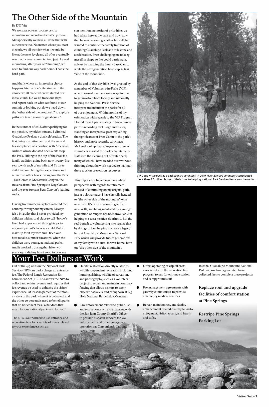
By DW Vitt
we have all done iT, looked up aT a
mountain and wondered what’s up there.
Metaphorically we have all done that with
our careers too. No matter where you start
at work, we all wonder what it would be
like at the next level; and all of us eventually
reach our career summits. And just like real
mountains, after years of “climbing”, we
need to find our way back home. That’s the
hard part.
And that’s where an interesting choice
happens later in one’s life; similar to the
choice we all made when we started our
initial climb. Do we re-trace our steps
and report back on what we found at our
summit or looking out do we head down
the “other side of the mountain” to explore
paths not taken in our original quest?
In the summer of 2018, after qualifying for
my pension, my oldest son and I climbed
Guadalupe Peak as a dual celebration. The
first being my retirement and the second
his acceptance of a position with American
Airlines whose donated obelisk sits atop
the Peak. Hiking to the top of the Peak is a
family tradition going back now twenty-five
years, with each of my wife and I’s three
children completing that experience and
numerous other hikes throughout the Park
- Fall Colors in McKittrick Canyon, the
traverse from Pine Springs to Dog Canyon
and the ever-present Bear Canyon’s leaning
rocks.
Having lived numerous places around the
country, throughout my career, I always
felt a bit guilty that I never provided my
children with a rural place to call “home”;
like I had experienced through trips to
my grandparent’s farm as a child. But to
make up for it my wife and I tried our
best to take summer vacations, when the
children were young, at national parks.
And it worked... during that hike two
years ago it did my heart good to hear my
The Other Side of the Mountain son mention memories of prior hikes we
had taken here at the park and how, now
that he was becoming a father himself, he
wanted to continue the family tradition of
climbing Guadalupe Peak as a milestone and
a celebration. Even challenging me to keep
myself in shape so I to could participate,
at least by manning the family Base Camp,
while the next generation heads up its first
“side of the mountain”.
At the end of that day hike I was greeted by
a member of Volunteers-in-Parks (VIP),
who informed me there were ways for me
to get involved both locally and nationally
helping the National Parks Service
interpret and maintain the parks for all
of our enjoyment. Within months of my
orientation with regards to the VIP Program
I found myself participating in backcountry
patrols recording trail usage and issues,
standing an interpretive post explaining
the significance of Pratt Cabin to the park’s
history, and most recently, carrying a
McLeod tool up Bear Canyon as a crew of
volunteers assisted the park’s maintenance
staff with the cleaning out of water bars;
many of which I have treaded over without
thinking about the work needed to maintain
these erosion prevention resources.
This experience has changed my whole
perspective with regards to retirement.
Instead of continuing on my original path,
just at a slower pace, I have literally headed
to “the other side of the mountain” on a
new path. It’s been invigorating to learn
new skills, and being mentored by a younger
generation of rangers has been invaluable in
helping me see a positive elderhood. But the
real benefit to volunteering is to realize that
by doing so, I am helping to create a legacy
here at Guadalupe Mountains National
Park which will provide future generations
of my family with a rural forever home; here
on “the other side of the mountain”.
Your Fee Dollars at WorkOut of the 419 units in the National Park Service (NPS), 111 parks charge an entrance fee. The Federal Lands Recreation En-hancement Act (FLREA) allows the NPS to collect and retain revenue and requires that fee revenue be used to enhance the visitor experience. At least 80 percent of the mon-ey stays in the park where it is collected, and the other 20 percent is used to benefit parks that do not collect fees. What does that mean for our national parks and for you?
The NPS is authorized to use entrance and recreation fees for a variety of items related to your experience, such as:
Direct operating or capital costs associated with the recreation fee program to pay for entrance station and campground staff
Fee management agreements with gateway communities to provide emergency medical services
Repair, maintenance, and facility enhancement related directly to visitor enjoyment, visitor access, and health and safety
Habitat restoration directly related to wildlife-dependent recreation including hunting, fishing, wildlife observation, and photography, such as a volunteer project to repair and maintain boundary fencing that allows visitors to safely observe native elk and pronghorn at Big Hole National Battlefield (Montana)
Law enforcement related to public use and recreation, such as partnering with the San Juan County Sheriff’s Office to provide dispatch services for law enforcement and other emergency operations at Canyonlands National Park (Utah)
In 2020, Guadalupe Mountains National Park will use funds generated from collected fees to complete these projects:
Replace roof and upgrade
facilities of comfort station
at Pine Springs
Restripe Pine Springs
Parking Lot
VIP Doug Vitt serves as a backcountry volunteer. In 2019, over 279,000 volunteers contributed more than 6.5 million hours of their time to helping National Park Service sites across the nation.
4 Visitor Guide
Hike Safely...• There is no water available along
park trails, so be sure to bring plenty with you. One gallon per person per day is recommended.
• Trails are rocky—wear sturdy shoes. Trekking poles are recommended.
• Carry a trail map.• Pack warm clothing and rain gear;
sudden weather changes are common.
SERVICES
Facilities and services within and near Guadalupe Mountains National Park are extremely limited. The nearest gas stations are 43 miles west (Dell City, TX), 35 miles east (White’s City, NM), or 65 miles south (Van Horn, TX). There is no campstore; bring everything you need with you.
INFoRMaTIoN & ExHIBITS
Pine Springs Visitor CenterElevation 5,730'. On Highway 62/180, 55 miles southwest of Carlsbad, 110 miles east of El Paso, and 65 miles north of Van Horn on Highway 54 and Highway 62/180. Open every day except December 25. Open daily 8:00 a.m. to 4:30 p.m. (Mountain Time Zone). Information, natural history exhibits, introductory slide program.
Frijole Ranch History MuseumThe ranch house features exhibits describing historic and current use of the Guadalupes. Grounds include a picnic area near a spring shaded by large oak trees. Open intermittently.
McKittrick CanyonHighway entrance gate is open 8:00 a.m. to 4:30 p.m. Mountain Standard Time. During Daylight Savings Time, hours are expanded 8:00 a.m. to 6:00 p.m. Restrooms, outdoor exhibits, slide program, picnic tables.
BaCkPaCkING
Eighty-five miles of trails lead through forests, canyons, and desert to ten backcountry campgrounds. A free permit is required if you plan to spend a night in the backcountry. Permits are issued at the Pine Springs Visitor Center and the Dog Canyon Ranger Station. For those coming through Carlsbad, Dog Canyon is a great place to begin a backpacking trip because it requires less elevation gain to get into the backcountry.
Wood and charcoal fires are prohibited. Camp stoves are allowed. Pack out all your trash. Pets are not allowed on park trails.
Preparation is the key to an enjoyable backpacking trip. Be prepared for changing weather conditions. Carry plenty of water—there are no water sources in the backcountry. Topographic maps, hikers’ guides, and information can be found at the Pine Springs Visitor Center and the Dog Canyon Ranger Station.
HoRSEBaCk RIDING
Sixty percent of the park’s trails are open to stock use. A backcountry permit is required for all stock use. These free permits are issued at the Pine Springs Visitor Center and Dog Canyon Ranger Station. Stock riding is limited to day trips only.
Stock corrals are available at Dog Canyon and near Frijole Ranch. Each has four pens and will accommodate a maximum of 10 animals. Reservations may be made two months in advance by visiting the park’s website (www.nps.gov/gumo).
HIkING
Pinery TrailDistance: .67 mileDifficulty: Easy, wheelchair accessible, slight incline on return trip.
Discover the desert as you walk to the ruins of the Pinery, a stagecoach station on the Butterfield Overland Mail Route in 1858. Trailside exhibits. This is the only trail pets on leash are allowed.
McKittrick Canyon TrailDistance: to Pratt Cabin 4.8 miles roundtrip, to the Grotto, 6.8 miles roundtripDifficulty: Moderate, level but rocky trail, 200' elevation gain to Grotto.
Follow an intermittent stream through the desert and canyon woodlands to the historic Pratt Cabin. A guidebook is available at the trailhead. The Grotto Picnic Area and Hunter Line Cabin are one mile beyond the Pratt Cabin. Please do not drink the water or wade in the creek. To protect this fragile environment, you are required to stayon the trail.
Guadalupe Peak TrailDistance: 8.4 milesDifficulty: Strenuous. Approximately 3,000' elevation gain, steep, rocky path.
Hike to the “Top of Texas” at 8,751' for spectacular views. Avoid the peak during high winds and thunderstorms. During warm temperatures, carry a gallon of water per person.
CaMPING
Water and restrooms are available, but there are no showers, RV hookups, or dump stations. The fee is $15.00 per night, per site, $7.50 with a Senior Pass (or existing Golden Age Passport) or Access Pass (or existing Golden Access Passport). No wood or charcoal fires are permitted; camp stoves are allowed.
Pine Springs CampgroundLocated near the Pine Springs Visitor Center, there are twenty tent and nineteen RV campsites (including a wheelchair accessible tent site) available on a first-come, first-served basis . Two group campsites are available for groups of 10-20 people. Reservations (for group sites only) can be made bon the park’s website (www.nps.gov/gumo) up to two months in advance. Campers planning on day hiking in McKittrick Canyon, to Guadalupe Peak or the Bowl will want to stay here.
Dog Canyon CampgroundLocated at the end of New Mexico Highway 137, 70 miles from Carlsbad and 110 miles from Park Headquarters, at an elevation of 6,290' in a secluded, forested canyon on the north side of the park. The campground has nine tent and four RV campsites (including a wheelchair accessible tent site). There is one group site for groups of 10-20 people. Reservations for the group site only can be made up to two months in advance by visit-ing the park’s website (www.nps.gov/gumo).
NPS
Ph
oto
NPS
Ph
oto
/Dav
e B
ieri
NPS
Ph
oto
/Dav
e B
ieri
NPS
Ph
oto
ENTRaNCE FEE
$10.00/person (16 & older)Free for Senior, access,and annual Pass cardholders
Trailhead Trail Distance Roundtrip
Description
Pine Springs Devil’s Hall Trail 4.2 miles Moderate to Strenuous. Hike in Pine Spring Canyon to the Hikers’ Staircase and Devil’s Hall. After the first mile, the trail drops into the wash and becomes very rocky and uneven. Turn left and follow the canyon bottom to the Hiker’s Staircase and beyond to the Devil’s Hall. Area beyond Devil’s Hall closed March - August due to sensitive species.
The Bowl 8.5 miles Strenuous. The Bowl shelters a highcountry conifer forest. Recommended route: Tejas Trail, Bowl Trail, Hunter Peak, Bear Canyon Trail, Frijole Trail, Tejas Trail (.1mile) back to campground. Trail climbs 2,500'. Bear Canyon Trail is very rocky and extremely steep.
El Capitán Trail 11.3 miles Moderate to Strenuous. Desert lovers will appreciate the rocky arroyos and open vistas while skirting along the base of El Capitán. Recommended route: El Capitán Trail, Salt Basin Overlook, and return to Pine Springs on the El Capitán Trail.
Frijole Ranch Manzanita Spring .4 miles Easy. Path is paved and wheelchair accessible. Hike to a small pond that serves as a desert oasis. Dragonflies, butterflies, and birds are active here in the warmer months. During winter, bluebirds frequent the area. Opportunities for chancing upon other wildlife are higher here as well.
Smith Spring Trail(entire loop)
2.3 miles Moderate. Look for birds, deer and elk as you pass Manzanita Spring on the way to the shady oasis of Smith Spring. Trees around Smith Spring include madrones, maples, oaks, chokecherry, ponderosa pines and others.
McKittrick Canyon
McKittrick Nature Loop
0.9 miles Moderate. Climb the foothills and learn about the natural history of the Chihuahuan Desert. Trailside exhibits.
Permian Reef Trail 8.4 miles Strenuous. For serious geology buffs, this trail has stop markers that can be used with a geology guidebook sold at the Visitor Center. There are excellent views into McKittrick Canyon from the ridgetop. Trail climbs 2,000'.
Dog Canyon Indian MeadowNature Loop
0.6 miles Easy. Enjoy a stroll around a meadow frequented by a variety of birds and other wildlife. Along the way you will see evidence of recent fires and regrowth.
Marcus Overlook 4.6 miles Moderate. Follow the Bush Mountain Trail to the ridgetop for a view into West Dog Canyon. Trail climbs 800'.
Lost Peak 6.4 miles Strenuous. Climb out of Dog Canyon on the Tejas Trail to visit the conifer forest above. Outstanding views from Lost Peak. Lost Peak is a short distance off trail to the right, before the horse hitches. Trail climbs 1,500'.
Salt Basin Dunes
Salt Basin Dunes(Day Use Only)
3-4 miles Moderate. Follow the old roadbed from the parking area, for a little over a mile, to the north end of the dune field. There is one high dune to ascend that some may find difficult. No shade. Enjoy the contrast of the pure white dunes with the sheer cliffs of the the Guadalupes as a backdrop. Great for sunrise or sunset hikes all year, and daytime hikes during the winter.
other popular hikes...
Protect the Park...• Stay on trails; don’t cut across
switchbacks or create new trails.• Carry out all trash, including
cigarette butts.• Report any trail hazards to the Pine
Springs Visitor Center or any park staff member.
• Collecting of natural, historic or prehistoric objects is prohibited.
Weather
AverageTemperature (° F)
Average Rainfall
High Low Inches
Jan 56 34 0.67
Feb 59 36 0.90
Mar 65 41 0.58
Apr 73 48 0.60
May 82 56 0.91
June 88 62 2.18
July 88 64 2.37
Aug 86 63 3.29
Sep 81 58 2.54
Oct 73 50 1.34
Nov 63 41 0.97
Dec 56 33 1.05
Average annual precipitation for Pine Springs (1980-2003)
17.4
Guadalupe Mountains National Park

Lightning may be the most awesome hazard faced by hikers. In our area, storms are common from May through September, and usually occur in the late afternoon or early evening. You can estimate the distance of a lightning strike in miles by counting the time in seconds between flash and sound and dividing by five.
The effects of being close to a lightning strike may be minor, such as confusion, amnesia, numbness, tingling, muscle pain, temporary loss of hearing or sight, and loss of consciousness. Severe injuries include burns, paralysis, coma, and cardiac arrest. Since injuries may not be obvious initially—burns and cardiac injury may not appear until 24 hours after the lightning strike—medical observation is recommended for all lightning victims.
Decrease your risk of injury from lightning:• Get an early start so that you can finish
your hike before storms erupt. • Be aware of current and predicted
weather. Watch the sky for development of anvil-shaped cumulus clouds. If a storm is building, descend to lower elevations.
• If a storm occurs, seek shelter. A car or large building offers good protection. Tents offer no protection.
• Turn off cell phones and other electronic equipment.
• If totally in the open, avoid single trees. Stay off exposed ridges.
• When caught in heavy lightning, the best stance is to crouch with feet close together, minimizing the opportunity for ground currents to find a path through the body. Crouch on a dry sleeping pad, if available.
• Stay out of shallow caves or overhangs. Large dry caves which are deeper than their width offer some protection; but do not lean against walls. Adopt the feet-together crouch.
• Valleys and ditches offer some protection. Avoid a depression with a stream.
• In forests, seek low spots under thick growth or smaller trees.
• Avoid standing water, fences, power lines, and pipelines. Discard metal hiking sticks.
• Groups should not huddle together. Scatter so if one person is injured, the others can help—stay at least 30 feet apart.
The body balances heat loss against heat gain to keep the core body temperature within narrow limits. With strenuous exercise in hot climates, heat gain can exceed loss. Core temperatures may rise, sometimes to dangerous levels. Dehydration exacerbates heat illness.
Heat Exhaustion develops over hours due to water and electrolyte loss from sweating; it causes collapse or gradual exhaustion with an inability to continue to exercise. Symptoms include headache, dizziness, fatigue, nausea, vomiting, muscle cramps, rapid pulse, thirst and profuse sweating, gooseflesh, chills, and pale skin, and low blood pressure—the victim may faint.
Heatstroke occurs in people who undertake heavy exertion in hot climates, and results in sudden collapse with extreme elevation of body temperature, decreased mental status, and shock. It is a medical emergency that can kill; begin treatment immediately. Symptoms include headache, drowsiness, irritability, unsteadiness, confusion, convulsions, coma, a rapid pulse and low blood pressure, and either dry or sweat-moistened hot skin.
PreventionDrink plenty of water when exercising in hot weather, before feeling thirsty and after feeling satisfied. Drink enough to produce clear urine regularly during the day. Eat high carbohydrate foods for energy. Avoid heavy exercise in high temperatures and high humidity. Wear light-colored clothes that fit loosely and cover all sun-exposed skin surface. Avoid alcohol and caffeine; both increase loss of fluid.
Treatment• Have the victim rest in the shade. • Remove excess clothing. • Wet the victim to increase evaporation. • Have the victim drink fluids; if
available, add 1/4 teaspoon salt and 6 teaspoons sugar to 1 quart of water.
• In serious cases, begin immediate, rapid cooling by one of these methods:
a) Increase evaporation by sprinkling water on the skin and fanning vigorously. b) Immerse the victim’s body in cool water. c) Place cold packs on the neck, abdomen, armpits, and groin.• Stop cooling when mental status
improves. Continue to monitor the victim.
• Contact a park ranger for assistance.
Hypothermia is a cooling of the body core when more heat is lost than is produced, and can be life threatening. Wetness and wind are a lethal combination that chill a person more rapidly than dry cold. Hy-pothermia can occur in any season of the year: the hiker exposed to a sudden summer hailstorm while wearing only a T-shirt and shorts is more likely to become hypothermic than a well-dressed winter hiker. Windchill adds to the problem, but affects only the ex-posed parts of the body. Wearing windproof clothing reduces the effects of windchill.
Signs of mild hypothermia include progres-sively worsening shivering, uncharacteristic behavior, grumbling about feeling cold, inappropriate excitement or lethargy, poor judgement, confusion, and hallucinations. The victim may experience stiff muscles and cramps, uncoordinated movements, and stumbling. Skin will be cold, pale and blue-gray due to constricted blood vessels.
As hypothermia becomes severe, shivering ceases. The victim’s behavior changes from erratic to apathetic to unresponsive. The pulse becomes weak, slow, and irregular. Breathing slows, pupils become dilated. Eventually the victim will slip into a coma.
PreventionKnow the weather forecast; carry appropriate extra clothing, such as a water/wind repellent shell, jacket, hat and mittens, and a space blanket or tarp for shelter. Evaporation of sweat is a major source of heat loss during exercise; try to avoid
sweating by wearing ventilated clothing. Watch for early signs of hypothermia, and act promptly to avert it. Gauge the day’s activity to the party’s weakest member; children are more prone to hypothermia than adults. Being exhausted, hungry, dehydrated, or demoralized prevents a proper response to cold and hastens the onset of hypothermia.
Treatment• Do not delay. • Find shelter out of the wind.• Remove wet clothes and replace with
dry; add layers and a wool cap to increase insulation.
• Give food and warm, sweet drinks. • If the victim is shivering strongly, place
victim inside a sleeping bag well-insulated from the ground.
• If the victim responds to rest and warmth, he may be able to continue hiking.
• For severe hypothermia, provide heat to the victim’s trunk after rescue by whatever means are available—body-to-body contact, hot water bottles, chemical heating pads, hot rocks wrapped in clothing. Place the heat sources in the groin and armpits and alongside the neck. Always have clothing between a heat source and the skin to prevent burns.
• Never leave a hypothermic victim alone.
• Contact a park ranger for assistance.
Lightning Heat
ColdHiker Safety for Different Weather Conditions
Visitor Guide 5
NPS
Ph
oto
/Mic
hae
l Hay
nie
NPS
Ph
oto
/Mic
hae
l Hay
nie
daTing back To prehisToric Times, rock cairns have been used around the world to mark trails and historic moments in history. Many of our national park sites mark trails by placing rock cairns sparingly along the paths. These cairns are placed so that from one stack, hikers can see the next cairn and navigate safely.
However, in recent years, unauthorized rock cairn building has become an epidemic!
Hikers wanting to mark their personal pas-sage by building their own cairns, adding to an existing rock cairn, or marking alter-native paths are aiding in the destruction of our wild lands. By adding to cairns or
Is this stack of stones
an important hiking
tool or a long-lasting
disturbance of the
environment?
building new ones, well-meaning hikers are altering the landscape, increasing the rate of erosion, and possibly leading people astray.
Please help keep your national parks wild and naturally beautiful by leaving the stones where they lie.
Help Protect the Park and Leave Rocks Unstacked

With their large size and very long tails, mountain lions are unmistakable. Adult males may be more than 8 feet in length and weigh an average of 150 pounds. Adult females may be up to 7 feet long and weigh an average of 90 pounds. Their tracks show 4 toes with 3 distinct lobes present at the base of the pad, which is generally greater than 1.5 inches wide. Claw marks are usually not visible since their claws are retractable.
Mountain lions take their prey, usually deer, by ambush. After spotting prey, a lion stalks using available cover, then attacks with a rush, often from behind. They usually kill with a powerful bite below the base of the skull, breaking the neck, then drag the carcass to a sheltered spot beneath a tree or overhang to feed on it. Often they cover the carcass with dirt or leaves and may return to feed on it over the course of a few days.
Although no one has had a physical encounter with a mountain lion at Guadalupe Mountains National Park, sightings have become more frequent in the last few years. Lions have increasingly shown more curiosity about people and less fear. Even with this increased lion activity, your chance of seeing one of these elusive creatures is extremely low. A few simple precautions may reduce the risk of a dangerous encounter.
Rattlesnakes are the only venomous snakes found in the Guadalupe Mountains. They are recognized by the triangular, flat head, wider than the neck; vertical, elliptical pupils, and a heat-sensitive “pit” located between the eye and the nostril. Rattles are generally present, but may be broken off. To avoid rattlesnake bites, stay on trails where you are more easily able to see a snake. Watch where you put your hands and feet; look around before sitting down. If you see a rattlesnake, leave it alone. Alert other members of your party. Do not attempt to move it; simply walk around it and continue your hike.
Do not use these methods to treat a snakebite:—a tourniquet, which causes severe damage if wound too tightly.—cold or ice; it does not inactivate the venom and poses a frostbite hazard.—the “cut-and-suck” method; it can damage blood vessels and nerves.—mouth suction; your mouth is filled with bacteria, and you may infect the wound.—electric shock; no medical studies support this method.—alcoholic beverages, which dilate vessels and compound shock.—aspirin, which increases bleeding.
If a lion is sighted, there are several things to remember:• Do not approach a lion, especially
one that is feeding or with kittens. Most mountain lions will try to avoid confrontation. Give them a way to escape.
• Stay calm; speak calmly yet firmly. Move slowly. Avoid prolonged direct eye contact.
• Face the lion and stand upright. Do all you can to appear larger. Raise your arms, or open your jacket.
• Protect small children by picking them up so they won’t panic and run.
• Back away slowly, if you can do it safely. Do not run! Running may stimulate a lion’s instinct to chase and attack.
• If the lion behaves aggressively, throw stones, branches or whatever you can get your hands on without crouching down or turning your back. Wave your arms slowly and speak firmly. What you want to do is convince the lion that you are not prey and that you may in fact be a danger to the lion.
• Fight back if a lion attacks you. People have fought back successfully with rocks, sticks, jackets, and their bare hands. Protect your head and neck with your arms. Remain standing or try to get back up.
• Please report all mountain lion sightings to a park ranger.
When you hike in mountain lion country:Travel in groups. Lions may key in on easy prey, like small children. Make sure children are close to you and within your sight at all times—do not let children run ahead of adults! Talk with children about lions and teach them what to do if they meet one.
First aid for a snakebite:• Get the victim away from the snake.
Rattlesnakes strike across a distance equal to half their body length and can bite more than once. Do not attempt to capture or kill the snake.
• Remove constrictive jewelry such as rings and watches.
• Suction with a venom extractor is only minimally effective and must be started within two to three minutes. Do not attempt oral suction or incising the skin.
• Use a sling or a splint to immobilize the limb loosely; keep it below the level of the heart.
• Look for signs of envenomation: severe burning pain at the bite site; swelling starting within 5 minutes and progress-ing up the limb (swelling may continue to advance for several hours); discolor-ation and blood-filled blisters develop-ing in 6 to 48 hours; and in severe cases, nausea, vomiting, sweating, weakness, bleeding, coma, and death. In 25% of rattlesnake bites, no venom is injected.
Mountain Lions
Rattlesnakes
Rattlesnakes are protected in National Parks;it is illegal to harm them.
Hiker Safety & Wildlife
6 Visitor Guide
• If there are immediate, severe symp-toms, keep the victim quiet; activity increases venom absorption. Have someone contact a ranger as soon as possible to begin evacuation.
• If there is no immediate reaction, you may choose to walk slowly with the victim to the trailhead. Begin evacuation as quickly as possible; contact a ranger for assistance. If evacuation is prolonged and there are no symptoms after six to eight hours, there has probably been no
envenomation. However, all bites can cause infection and should be treated by a physician.
• Transport the victim to a medical facility where antivenin is available. The closest facility to the park is Carlsbad Medical Center, at the north end of Carlsbad, New Mexico on US 285 (2430 West Pierce); driving time is 1½ hours from Pine Springs.
To avoid rattlesnake bites, stay on trails where you are more easily able to see a snake.

Wildland Caving Opportunities on the Lincoln National Forest
Sitting Bull Falls (Lincoln National Forest)
Visitor Guide 7
Visiting caves on the Lincoln National Forest can be challenging and remote, requiring specialized equipment, weeks of planning, and extensive training.
By Brad Boltond o yo u l i k e a c h a l l e n ge a n d to
to travel where you rely on your own wits and physical strength to climb and negotiate through cave passages? For folks who really enjoy ‘wild caving’-type of trips, there are many adventures to be found in nearby Lincoln National Forest.
The Lincoln National Forest manages numerous caves, many of which are in the same mountains shared with the two national parks. While nothing can compare to Carlsbad Caverns, many Forest Service caves are spectacular, unique, and world-renowned for exquisite formations. In addition, many caves have vertical entrances requiring rappeling and rope work to enter! New discoveries are made yearly as scientists come to the Lincoln to study the geology and biology of caves. The caves are in a completely natural setting nestled in the high mountains and deep canyons. Visiting caves in the Lincoln National Forest can be challenging and remote, requiring specialized equipment, weeks of planning, and extensive training.
Below ground, management of backcountry caves is very similar for the different agencies. That is because the same 1988 Cave Protection Act is the federal law that requires management of significant caves for all national parks and national forests. Lincoln National Forest promotes conservation by facilitating a backcountry cave permit system, and by coordinating volunteers from the National Speleological Society (NSS) who monitor the caves for research, wildlife conservation, and preventing misuse.
By Jerermy Evans
t h e gua da lu p e ra n ge r d i s t r i c t,
the southern-most district of the Lincoln
National Forest, has many spectacular
recreation opportunities. Remote, quiet and
mysterious, the District beckons the visitor
to explore this unique desert landscape.
The Guadalupe Ranger District shares its
southern boundary with two national parks:
Guadalupe Mountains and Carlsbad Caverns.
Hiking, camping, hunting, bird watching,
and horseback riding are just some of the
incredible activities that can be enjoyed on the
district. One of the recreational highlights is
Sitting Bull Falls Recreation Area. It sits at the
end of a long remote canyon and has a series of
waterfalls (fed from springs atop the canyon)
that create a large pool of water at the base
of the falls, 150 feet from top to bottom. The
Sitting Bull Falls Recreation Area meets ADA
guidelines for accessibility and some of the
features include paved sidewalks, restrooms,
picnic tables, rock cabanas, fresh water, trash
containers, and a viewing deck of the waterfall.
Sitting Bull Falls and the surrounding
landscape are the remnants of an ancient reef
known as Capitan Reef. Approximately 260
million years ago, the area was on the edge of
a huge inland sea. The predominant geology
of the area is limestone and is full of fissures
and caves that were slowly eroded by acidic
water over long periods of time. Deep and
rough canyons were carved by annual flooding
and rains. Other geologic forces have created
picturesque valleys teeming with wildlife and
those forces, over time, helped create the
underground water reservoirs and springs that
feed into Sitting Bull Falls.
Come and enjoy Sitting Bull Falls and
the surrounding area. Take a hike on the
many trails or relax and have a picnic
with your family. Whatever you decide
to do, your adventure to the Guadalupe
Ranger District will be memorable. Don’t
forget to come prepared. Bring plenty of
water and pay attention! Deer, javelina,
mountain lions, snakes, tarantulas,
rabbits, and many other animal species
call the area home. If you decide to go out
and explore the backcountry, please go
prepared; the weather in this area can
be unpredictable and so can the wildlife!
Please be safe and
enjoy YOUR national forest.
The Guadalupe Mountains sit on the northern
edge of the Chihuahuan Desert and have a
rich and diverse geologic and archaeological
history. American Indians first came into
the area around 10,000 years ago and the
Mescalero Apache called this area their home
for many, many years. Spanish explorers came
to the area in the 1500s; the horses they brought
proved to be very valuable to the Apache. By
the mid-1800s explorers, settlers, ranchers,
businessmen, cattleman, and outlaws had
migrated into the area. Because of the rough
and remote terrain, the Guadalupe Mountains
were settled very slowly.
In the 1930’s, the Civilian Conservation Corps
was assigned to the area and built impressive
stone structures that still stand today as the
picnic sites at Sitting Bull Falls. The 1970s
ushered in a little more development: crews
installed vault restrooms, added more cabanas
and improved the trail to the falls. In the 1980s,
a route to the top of the falls was built by the
Youth Conservation Corps. Then on Easter
Sunday of 2011, the Last Chance Fire burned
through the area, severely damaging the
picnic cabanas and destroying the trees and
vegetation. Sitting Bull Falls was closed for a
year while repairs were made; once reopened,
the area was damaged again by a flood event
in September of 2013. Another flood in 2014
delayed reconstruction efforts. Finally, by
May 2015, all reconstruction and repairs were
completed. A new walkway was built, which
leads to a viewing deck and a bird’s-eye view
of the falls. The entrance road to the well-
known site was reconstructed and “re-paved”
the way to a whole new experience!
It is a day-use area open from 9 - 5 daily
(October to March) or 8:30 - 6 (April to
September); the standard amenity fee is a
bargain at $5 per vehicle. Visitors can wade in
the water below the falls, hike, or picnic. The
picnic sites have tables and grills, but you’ll
need to bring your own charcoal and be aware
of any fire danger warnings. Many of the picnic
sites provide overhead shelter from the sun’s
rays that bear down on the area most of the
day. Fresh water and restroom facilities are
available. There is a paved, ADA accessible
path to the falls viewing area. Camping is not
allowed in the falls day use area, but is allowed
almost anywhere else on the Guadalupe
Ranger District.
If you have questions, please visit the
Guadalupe Ranger District office at
5203 Buena Vista Drive in Carlsbad
or call 575-885-4181.
Sitting Bull Falls is approximately 42 miles west
of Carlsbad, New Mexico and can be reached
by car via Highway 285 to Highway 137 and
then Forest Road 276 / County Road 409. Pets
on leashes are allowed.
Imagine starting out on a caving trip to Lincoln National Forest; things can be very different. Like many national forests, primitive roads provide driving access into some very remote areas. These roads can be extremely rough; many folks opt to get out and hike along the beautiful ridgetops. Primitive camping is allowed almost everywhere and car camping is allowed within 300’ of most roads. After finding the perfect campsite high in the Guadalupe Mountains, the next task is actually finding the caves themselves. There are no established trails that take visitors to wild caves, so finding the cave entrance can be an extensive search along the side of a steep canyon, with the added challenges of orienteering and following maps. To help groups find caves and promote conservation, Lincoln National Forest facilitates a public trip leader program. Members of the NSS with extensive cave experience lead others to find new adventures.
If ‘wild caving’ sounds like fun, there is an easy way to get started right where you live. There are caving clubs called “Grottos” located across the country as part of the National Speleological Society. Finding and contacting one of these Grottos is a click away at www.caves.org. There you will find a U.S. map and contact information for caving enthusiasts from across the country. The National Speleological Society is a great partner organization and NSS Grottos provide the necessary training and education needed for visiting the backcountry caves of Lincoln National Forest.

8 Visitor Guide
Nearby Attractions
www.emnrd.state.nm.us/SPD/livingdesert-statepark.htmlCome face to face with a mountain lion at this unique zoo and botanical garden offering an opportunity to experience the Chihuahuan Desert first-hand. See a large collection of live animals, including the rare Mexican gray wolf, and the roadrunner, the state bird of New Mexico. There is also an unusual collection of cacti and other succulents from around the world.
The park is located high atop the Ocotillo Hills overlooking the northwest edge of Carlsbad, just off U.S. Highway 285, and features exhibits, an art gallery, gift shop, and refreshments.Open daily except December 25.
Open all year—24 hours/day.Wheelchair accessible.
FeesDay Use Only—$5.00 per vehicleCamping—$14.00 per night ($10.00 for each additional vehicle driven into the same site)Primitive Camping Area—$8.00 per vehicle per night.
BRaNTLEy LakE STaTE PaRk
575-457-2384www.emnrd.state.nm.us/SPD/brantley-lakestatepark.htmlLocated 12 miles north of Carlsbad on U.S. Highway 285, the campground has 51 RV sites with water and RV electric hook-ups (a few with sewer), a dump station, playground, restroom with hot showers, shelters, tables and grills. Other facilities include picnic areas with sheltered tables and grills, playground, a fishing dock, boat ramps with docks, and a visitor center.
575-885-4181www.fs.usda.gov/lincoln/homeThe forest encompasses 1,103,441 acres for hiking, caving, camping, picnicking, horseback riding, hunting and sightseeing. Maps are available at the Guadalupe Ranger District Office located at 5203 Buena Vista DriveCarlsbad, NM 88220.
575-234-5972www.blm.gov/nm/st/en/fo/Carlsbad_Field_OfficeBlack River Recreation AreaThis 1,200 acre oasis in the Chihuahuan Des575ert is home to rare species of plants, fish, and reptiles in and around the river. The most frequently visited site is the Cottonwood Day Use Area, which includes a wildlife viewing platform, picnic tables, and a toilet. Turn west onto CR418, travel two miles, and then turn left at the fork.
La Cueva Non-Motorized Trail SystemThe trail system contains more than 15 miles
of maintained trails. The non-motorized trails are used by mountain bikers, hikers, and equestrians. The trails wind through the rolling limestone foothills of the Guadalupe Mountains and the rugged Chihuahuan Des-ert environment.
The area is located partially within the city limits of Carlsbad, NM. From Lea Street, go west to Standpipe Rd. Turn south and travel 3 miles to the gravel access road. Turn right and travel approximately 0.3 miles to the trailhead and parking area. There are no facilities other than the parking area and trail signs.
BUREaU oF LaND MaNaGEMENT (BLM)
Five Points & Indian VistasEleven miles south of State Highway 137 on Forest Route 540, an improved gravel road. A panoramic view of the desert from the top of the Guadalupe Mountains. Interpre-tive signs explain natural features. 575-887-5516
LINCoLN NaTIoNaL FoREST (GUaDaLUPE DISTRICT)
LIVING DESERT zoo & GaRDENS STaTE PaRk
Wheelchair accessible.
Summer Hours(Memorial Day to Labor Day)8:00 a.m. to 5:00 p.m.Last tour entry—3:30 p.m.
Winter Hours (after Labor Day)9:00 a.m. to 5:00 p.m.Last tour entry—3:30 p.m.
FeesAges 13 and up $5.00Children 7 - 12 $3.00Children 6 and under freeGroup (20+) discount available.
575-785-2232www.nps.gov/cave Visitor Center727 Carlsbad Caverns HighwayCarlsbad, NM 88220
CaRLSBaD CaVERNS NaTIoNaL PaRk
Carlsbad Caverns National Park features a immense cave system of highly decorated chambers, and from mid-May to mid-October, a spectacular batflight each evening. Visit the website for the latest information on hours of operation.