this plan of management was prepared pursuant to … · this plan of management was prepared...
TRANSCRIPT


2
This plan of management was prepared pursuant to section 38 of the National Parks and Wildlife Act 1972. This Ramsar Management Plan for the Piccaninnie Ponds Karst Wetlands was prepared by Water’s Edge Consulting and Associates for DENR Mt Gambier.
Citation: Butcher, R.J., Cottingham, P., Hale, J., Philips, B., and Muller, K. (2011). Ramsar Management Plan for Piccaninnie Ponds Karst Wetlands. Front cover photograph courtesy Steve Clarke.

3
FFoorreewwoorrdd
The South Australian Government recognises that wetlands are unique parts of our landscapes. They support a rich natural heritage of plant and animal life and have many cultural and economic values including recreation, tourism, fishing and water supply. It is essential that they are conserved and wisely managed. The Piccaninnie Ponds are one of Australia’s best examples of ‘rising limestone springs’, and collectively form the largest remnant of coastal fresh-water wetlands in the Southeast. The wetlands are
surface expressions of a much larger underground cave system of great beauty and interest, which has made the site one of Australia's premier cave-diving destinations. Our vision for these wetlands is a shared objective of the Ramsar Convention on Wetlands - an international treaty that focuses on the conservation of internationally important wetlands and the promotion of wise-use principles for all wetlands. This Ramsar Site Management Plan establishes management strategies and actions for maintaining and improving the character of the Piccaninnie Ponds wetlands, and proposes regimes for monitoring and adaptive management. Importantly, work will be closely monitored so that information gained and lessons learnt can be incorporated into future actions. The wetlands at this site support 61 species of conservation significance including the critically endangered Orange-bellied Parrot; they also provide habitat for 20 migratory bird species. Over 30 vegetation associations including freshwater lakes and swamps, coastal dunes, silky tea tree thickets, and terrestrial grasslands and woodland are represented. The Piccaninnie Ponds are a valuable community asset and a unique visitor destination. Local groups have dedicated thousands of volunteer hours over many years to assist the site conservation and restoration program. These activities have been an exemplar for future natural resource management initiatives as far as community education, participation and awareness activities are concerned. The Government will continue to foster the involvement of the community at this special site as we work towards implementing the strategies and actions as outlined in this Ramsar Site Management Plan. Hon Paul Caica MP Minister for Sustainability, Environment and Conservation

4
SYNOPSIS Reserve name and type: Piccaninnie Ponds Karst Wetlands (Ramsar
Wetland of International Importance).
Management Region: South East.
Location: 30 km south-east of Mt Gambier, South East Naracoorte Coastal Plain bioregion.
First proclamation date: 1976
Purpose/reason for proclamation:
Protection of vegetation associations and recreational values such as cave diving.
Piccaninnie Ponds Karst Wetlands Ramsar site:
Area
Piccaninnie Ponds Conservation Park
Total of 862 hectares
Biodiversity value: Nominated as a Wetland of International Importance under the Convention of Wetlands (Iran 1971). One of the most important remnant wetlands in the South East region. An exceptional example of a karst spring wetland system supporting the largest coastal fen wetlands remaining in South Australia. Supports a range of ecological services including threatened species at the international, national and regional scale, provides key habitat for different species at critical life stages including migratory waterbirds, and supports high regional diversity.
Cultural values: Of significance to the Boandik community as a permanent freshwater source important for story-telling, food, shelter and other resources. It was an important source of materials to trade with other indigenous people prior to European settlement.
Major activities/uses: • Internationally renowned cave diving site.
• Wetland based recreation activities include bush walking, bird watching and beach fishing.
Management goals: Maintenance of the ecological character of the site through the wise use of the wetlands for recreational activities and conservation and restoration of the wetland areas.

5
Key strategies: • Develop collaborative approach to research and management of the Piccaninnie Ponds Karst Wetlands.
• Work with interstate and regional agencies to minimise the off-site impacts to the ecological character.
• Undertake an integrated monitoring program to collect baseline data and ensure maintenance of ecological character.

6
Table of Contents 1 Introduction .................................................................................................................9
1.1 Background...............................................................................................................9 1.2 Obligations under the Ramsar Convention on Wetlands ...............................12 1.3 Vision.........................................................................................................................14 1.4 Management objectives ......................................................................................14 1.5 Guiding principles ..................................................................................................15
2 Site description..........................................................................................................16 2.1 Location ...................................................................................................................16 2.2 Overview of site ......................................................................................................17
2.2.1 Climate...............................................................................................................18 2.2.2 Geology and geomorphology .....................................................................19 2.2.3 Groundwater and surface water interactions ...........................................21 2.2.4 Peat soil formation – fen wetland creation ................................................22 2.2.5 Groundwater quality ......................................................................................22 2.2.6 Vegetation associations and habitat types ...............................................22 2.2.7 Notable fauna and flora................................................................................24
2.3 Ecological character of the Piccaninnie Ponds Karst Wetlands ...................27 2.3.1 Ramsar criteria justification and wetland types.........................................27 2.3.2 Ramsar wetland types....................................................................................28 2.3.3 Critical components and processes ............................................................29 2.3.4 Essential components and processes...........................................................31
2.4 Social and cultural values of the Piccaninnie Ponds Karst Wetlands ...........32 2.4.1 Recreation and tourism..................................................................................32 2.4.2 Cultural values .................................................................................................33
3 Land tenure, management and planning context ...............................................33 3.1 Land tenure.............................................................................................................33 3.2 Management and planning context .................................................................34
3.2.1 Ramsar Convention and EPBC Act 1999.....................................................34 3.2.2 Native title.........................................................................................................34 3.2.3 Other notable national strategies and legislation.....................................34 3.2.4 State and regional legislation, strategies and plans .................................35 3.2.5 Other notable state strategies and legislation...........................................36 3.2.6 Regional planning ...........................................................................................37
4 Threats and risks........................................................................................................38 5 Management strategies and actions .....................................................................40
5.1 Ecological management .....................................................................................40 5.1.1Ecological management objectives .............................................................40 5.1.2 Ecological management strategies ............................................................41 5.1.3 Ecological management actions ................................................................42
5.2 Recreational and landuse management .........................................................46 5.2.1 Recreational and surrounding landuse objectives ...................................46 5.2.2 Recreational and landuse management strategies ................................46 5.2.3 Recreational and landuse management actions ....................................47
5.3 Operational management objectives ...............................................................50 5.3.1 Operational objectives ..................................................................................50 5.3.2 Operational management strategies .........................................................50 5.3.3 Operational management actions .............................................................50

7
6 Communication management plan ......................................................................52 6.1 Improving awareness of the site amongst all stakeholders ............................53 6.2 Volunteer opportunities.........................................................................................53 6.3 Increase participation by indigenous people in caring for the site ..............54
7 Monitoring and adaptive management ................................................................57 7.1 Established monitoring ..........................................................................................57
7.1.1 Hydrological monitoring.................................................................................57 7.1.2 Water quality monitoring ...............................................................................58 7.1.3 Vegetation monitoring ...................................................................................58 7.1.4 Waterbird monitoring......................................................................................58 7.1.5 Fish monitoring .................................................................................................59
7.2 Monitoring to detect changes in ecological character.................................59 7.2.1 Applying limits of acceptable change .......................................................59 7.2.2 Linking monitoring to management ............................................................59 7.2.3 Monitoring the rehabilitation of Pick Swamp .............................................65
8 References.................................................................................................................66 Appendix A: Ramsar Convention matters ................................................................69 Appendix B: Adaptive management framework ....................................................76 Appendix C: Plant species recorded from Piccaninnie Ponds Karst Wetlands ..... 79 Appendix D: Listed species and communities of conservation significance ........83 Appendix E: Consultation on the Ramsar listing of the Piccaninnie Ponds Karst Wetlands. .......................................................................................................................86

8
ABBREVIATIONS ANZECC Australian and New Zealand Environment and Conservation
Council CAMBA China Australia Migratory Bird Agreement DENR Department of Environment and Natural Resources, South
Australia DfW Department for Water, South Australia DIWA Directory of Important Wetlands in Australia (Environment
Australia 2001) ECD Ecological Character Description EPBC Act Environment Protection and Biodiversity Act, 1999
(Commonwealth) IUCN International Union for Conservation of Nature and Natural
Resources (The World Conservation Union) JAMBA Japan Australia Migratory Bird Agreement LAC Limits of Acceptable Change RIS Ramsar information sheet RMP Ramsar management plan ROKAMBA Republic of Korea Australia Migratory Bird Agreement SEWPaC Department of Sustainability, Environment, Water, People and
Communities (Commonwealth) ACKNOWLEDGEMENTS COMMUNITY REFERENCE GROUP Maureen Christie, Friends of Shorebirds Peter Feast, Port MacDonnell Landcare Group Ian Kenny, Friends of Mt Gambier Parks Bryan Haywood, Birds South East Aunty Hilda Blessios Aunty Valda Brennan Ken Jones Roselea Millard TECHNICAL REFERENCE GROUP Steve Clarke, DENR Mt Gambier Randall Johnson, DENR Mt Gambier Ross Anderson, DENR Mt Gambier Mark Bachmann, DENR Mt Gambier Max Arney, Lower South East NRM Group Katrin Springer, South East NRM Board Nick Hunt, Lower South East NRM Group Grant Pearce, DFW Mt Gambier, and Cave Diving Association Australia Cameron Wood, DFW Mt Gambier Claire Harding, DFW Mt Gambier Russell Seaman, DENR Adelaide Dr Belinda McGrath-Steer, DENR Adelaide Don Mount, DENR Mt Gambier
9
1 Introduction
1.1 Background The Piccaninnie Ponds Karst Wetlands are located in the South East of the state of South Australia. The site is situated 30 kilometres south east of Mount Gambier which has a population of 24 000. The site is bounded by the South Australia – Victoria border to the east, the Southern Ocean to the south and privately owned cropping and grazing land to the north and west, refer Figure 2. The Piccaninnie Ponds Karst Wetlands are the remnant of a larger wetland area which extended from Green Point to the Glenelg River Mouth in Victoria. The original wetland covered 1100 ha, much of which was drained post the Second World War. It supported large areas of open water, reed beds, coastal peat fens, a mobile coastal dune system, grassy open woodlands and dense thickets of Tree Everlasting (Ozothamnus ferrugineus), Tall Saw-sedge (Gahnia clarkei) and Silky Tea Tree (Leptospermum lanigerum). Drainage undertaken to facilitate grazing significantly reduced the extent of the wetland system. Only Piccaninnie Ponds and Crescent Pond plus a series of smaller spring outflows remain, and water no longer reaches the Glenelg River estuary. However, despite the loss of habitat this wetland system remains one of the most extensive examples of karst wetlands in South Australia, providing habitat for at least seven nationally threatened species, and at least 61 species of State significance. The Piccaninnie Ponds Conservation Park is currently included in the Directory of Important Wetlands in Australia, and is situated within one of 15 national biodiversity ‘hotspots’ listed by the Australian Government in October 2003. The Australian Government defines biodiversity hotspots as areas that support natural ecosystems that are largely intact and where native species and communities associated with these ecosystems are well represented. They are also areas with a high diversity of locally endemic species, which are species that are not found or are rarely found outside the hotspot (http://www.environment.gov.au). The remnant vegetation associations present at this site are significant as they are the largest remnant of ‘coastal peat fen’ in South Australia. Piccaninnie Ponds Conservation Park was first nominated for reservation based on the presence of Silky Tea Tree (Leptospermum lanigerum) and Bottlebrush Tea Tree (Melaleuca squarrosa). This vegetation association is highly threatened in South Australia as a result of drainage. Prior to the dedication of the conservation park in 1976, the area had been subjected to a number of changes, particularly relating to the hydrology of the site. Originally the discharge from the karst springs flowed east along Freshwater Creek to the Glenelg River Mouth, however a number of changes ultimately led to this connection being broken and new outlet drains being created. Currently several

10
regulated outlets discharge excess water directly south through the dunes to the Southern Ocean. The conservation park’s management plan (DEP 1992) outlined the general objectives as described by the National Parks and Wildlife Act 1972 (see section 3.2.4) with the additional specific objectives as follows (DEP 1992):
• To provide access and a range of recreation facilities in appropriate sites to facilitate visitor enjoyment;
• To develop interpretation and education programs and provide information on recreation opportunities, resources and management;
• To contribute to regional and State tourism while protecting the natural values of the Park; and
• To provide managed recreation opportunities for cave diving in the Park.
The land tenure surrounding the Piccaninnie Ponds Conservation Park is mainly grazing. Two properties, Pick Swamp and Lapatha (Figure 3), were purchased by DENR South Australia in 2005 and added to the conservation park in 2010. The Pick Swamp portion of the conservation park is 230 ha and forms the Western extent of the conservation park. In the late 1970s the habitat of Pick Swamp was still virtually contiguous with that of the Piccaninnie Ponds Conservation Park to the east. However, over the subsequent 25 years, clearance and continued drainage of approximately 145 ha, left the remaining wetland habitat highly isolated and degraded (Bachmann 2002). In addition to the drainage and clearing the land underwent “improvement” with exotic grass species such as Yorkshire Fog Grass (Holcus lanatus), Kentucky Blue Grass (Poa pratensis) and Tall Meadow Fescue (Festuca arundinacea) all being introduced. In 2006 approximately 200 head of cattle were being grazed on the property. Grazing ceased on the property in April 2007. In 2006 hydrological restoration and revegetation works began at the site. Part of the restoration program included the construction of a weir and fishway on Outlet Creek and an additional weir in Pick Swamp drain outlet to the west of the site to aid in manipulating surface water levels. These activities, and others, mean that the site can now be managed sympathetically with its historical hydrology. The South Australian government committed to the nomination of the Piccaninnie Ponds Karst Wetlands as a Wetland of International Importance under the Ramsar Convention in early 2011. Despite the historical management practices of land clearance and altered hydrology this system remains an outstanding example of karst spring and coastal fen wetlands. The key values of the site are summarised below.

11
International • Piccaninnie Ponds Karst Wetlands meet five of the nine Ramsar criteria for
identifying Wetlands of International Importance (See Appendix A). • Provides habitat for 25 species of migratory birds listed under international
agreements and conventions (JAMBA, CAMBA, ROKAMBA) • Regularly supports in excess of 1% of the individuals in the population of the
Sanderling (Calidris alba) on the beach incorporated within the site and adjacent areas.
• Internationally renowned as a cave diving destination. National • Included in A Directory of Important Wetlands in Australia (Environment
Australia 2001) (Piccaninnie Ponds Conservation Park). • Exceptional example of a karst spring and coastal fen wetland complex. • Important winter migration habitat for the critically endangered Orange-
bellied Parrot (Neophema chrysogaster). • Important habitat for the nationally endangered Australasian Bittern
(Botaurus poiciloptilus). • Supports populations of the nationally endangered Glenelg spiny freshwater
crayfish (Euastacus bispinosus). • Supports populations of the nationally vulnerable Yarra Pygmy Perch
(Nannoperca obscura) and Dwarf Galaxias (Galaxias pusilla). • Supports populations of the nationally vulnerable Maroon Leek-orchid
(Prasophyllum frenchii). • Supports populations of the nationally vulnerable Swamp Greenhood
(Pterostylis tenuissima). • Included on the Register of the National Estate (Australian Heritage
Commission) as a place of natural heritage importance. South Australia • Contains the largest remnant of coastal fen wetlands in South Australia. • Supports 61 species of conservation significance at the state level, including
21 bird species and 23 plant species. • Provides habitat for 79 species of waterbirds, five of which have been
recorded breeding on site. • One of only two karst wetland systems in the reserve system. • Supports significant stands of Silky Tea Tree tall shrubland (Leptospermum
lanigerum) which is considered vulnerable in South Australia South East • Supports 10 of the 15 native fish species found in the region including a
mixture of obligate freshwater and diadromous species. • Contains two regionally threatened vegetation communities. • Lacks any introduced fish species. • Contains a high proportion of regional biodiversity, being comparable in
species richness to the larger Bool and Hacks Lagoon and Lake Frome • One of the few remaining wetlands with permanent water supply, and
considered an important drought refuge.

12
• Supports a diverse array of habitat including 30 vegetation associations. • Significant cultural value to the Boandik community. • Important tourism site as it attracts 20,000 visitors annually.
1.2 Obligations under the Ramsar Convention on Wetlands As a signatory of the Ramsar Convention on Wetlands, Australia has a number of obligations relating to the management of its designated Wetlands of International Importance, or Ramsar sites. These obligations are described in Articles 3.1 and 3.2 of the Convention as follows.
Article 3.1: “The Contracting Parties shall formulate and implement their planning so as to promote the conservation of the wetlands included in the List, and as far as possible the wise use of wetlands in their territory.” Article 3.2: “Each Contracting Party shall arrange to be informed at the earliest possible time if the ecological character of any wetland in its territory and included in the List has changed, is changing or is likely to change as the result of technological development, pollution or other human interference. Information on such changes shall be passed without delay to the organization or government responsible for the continuing bureau duties specified in Article 8.”
The Ramsar Convention interprets the above obligations as a commitment by signatory governments to retain the ‘ecological character’ of their listed sites. For this reason, gaining a detailed understanding of the ecological character of a Ramsar site is a fundamental tool for guiding management actions. For this site this is contained in the companion document to this plan: Ecological character Description, Piccaninnie Ponds Karst Wetlands. Also of note in this context is that the Australian Government introduced the Environment Protection and Biodiversity Conservation Act (the EPBC Act) in 1999. The EPBC Act establishes a Commonwealth process for the referral, and possible assessment, of proposed actions that may have a significant detrimental impact on ‘matters of national environmental significance’, which includes Ramsar sites. The EPBC Act also requires that the Commonwealth “… use its best endeavours to ensure a plan for managing the wetland in a way that is not inconsistent with Australia’s obligations under the Ramsar Convention or the Australian Ramsar management principles is prepared and implemented in cooperation with the State and Territory.” (Section 3.3.3, of the Act). Under the Act it is expected that plans of management be reviewed at least every seven years.

13
This plan has been prepared taking into consideration the Australian Ramsar Management Principles (Appendix A). This document, the Ramsar Management Plan (RMP), is the third of the key documents required to support Ramsar nomination, and should be read in conjunction with the Ecological Character Description (ECD) report (Butcher et al. 2011) which includes the Ramsar Information Sheet. The requirements for managing Ramsar wetlands are illustrated in Figure 1. Appendix A provides further details about the Ramsar Convention and qualities of this site and management implications.
Figure 1: The requirements for the management of Ramsar sites (adapted from DEWHA 2008).
14
1.3 Vision The management vision for this site is to:
Ensure the Piccaninnie Ponds Karst Wetlands retain their ecological, cultural, and social values.
1.4 Management objectives The objectives of this plan of management are as follows:
Ecological management objectives
• Maintain, enhance and restore the globally recognised ecological and biological assets of the site; and
• Reinstate hydrological regime and connectivity across the site.
Recreational and surrounding landuse objectives
• Manage recreational activities by the local community and visitors to ensure they are ecologically sustainable;
• Promote the Piccaninnie Ponds Karst Wetlands an internationally
important wetland within the lower South East region;
• Work with surrounding landholders to assist them in minimising impacts on the Ramsar area, and to promote rehabilitation of adjoining habitat areas; and
• Manage fire to ensure the protection of life and property, the
maintenance of the ecological character of the site, and the protection of cultural values.
Community involvement objectives • Improve awareness among all key stakeholders of the natural values of
the site and of indigenous peoples associations with the area; • Increase opportunities for the local community to become actively
involved in the management of the park by maintaining existing partnerships and creating new opportunities for involvement; and
• Increase opportunities for participation by indigenous peoples in caring for the Piccaninnie Ponds Karst Wetlands Ramsar Site.
15
Operational objectives • To fulfill Australia’s obligations under the Ramsar Convention to ensure
the ecological character of the Piccaninnie Ponds Karst Wetlands site is rehabilitated and then maintained;
• To ensure that implementation of this plan, including on-going monitoring to assess changes to the ecological character of the site, is done in close coordination with other relevant regional plans identified herein (section 3); and
• To provide the necessary ongoing funds and other resources to achieve the vision and above objectives of this management plan.
1.5 Guiding principles Guiding principles for the development and implementation of the Piccaninnie Ponds Karst Wetlands Ramsar site management plan are as follows: 1. Adaptive management, or learning by doing, will be applied. This
requires on-going monitoring of the responses by the wetland system to the management actions taken. This then helps to inform those coordinating implementation so that, as necessary, these actions can be adjusted or fine tuned. See Appendix B for more about how this approach operates.
2. The precautionary approach will be applied. This states as follows; “Where there are threats of serious or irreversible damage, lack of full scientific certainty shall not be used as a reason for postponing cost-effective measures to prevent environmental degradation.” (Rio Declaration, Principle 15).
3. Open, transparent and consultative decision making will be applied. 4. Those implementing the plan will work with those responsible for
managing ecologically or hydrologically-linked areas where activities may offer a potential risk to the environmental, social, cultural or economic values of the Ramsar wetland. Where such risks are identified, efforts will be made to have these minimised or mitigated.
5. The cultural values and associations with the area for the Boandik and
other local indigenous people will be recognised and respected. 6. Places of cultural significance to the early European settlers will be
identified and recognised through appropriate awareness raising activities.
16
7. Recognition will be given to regional as well as broader State and inter State, initiatives and obligations, especially in relation to water management and salinity.
8. The availability of resources, both human and financial, may limit the
pursuit of the vision and implementation of this plan, and, where necessary, management actions will be prioritised to match available resources.
2 Site description
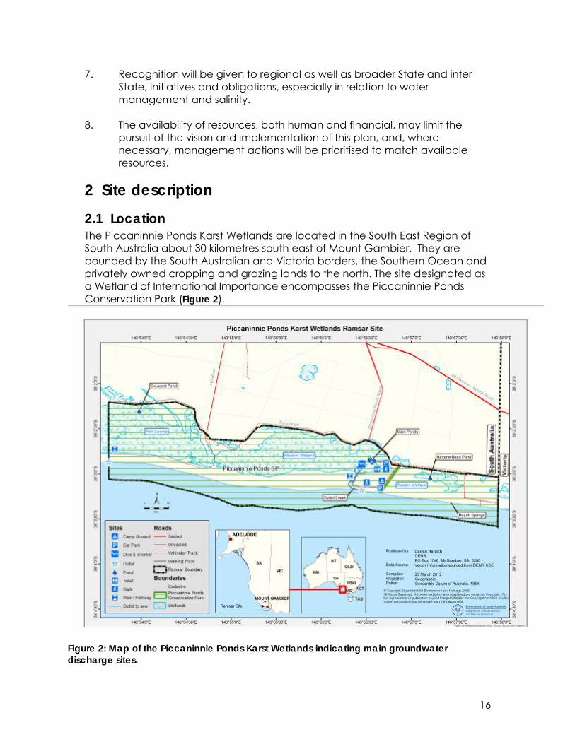
2.1 Location The Piccaninnie Ponds Karst Wetlands are located in the South East Region of South Australia about 30 kilometres south east of Mount Gambier. They are bounded by the South Australian and Victoria borders, the Southern Ocean and privately owned cropping and grazing lands to the north. The site designated as a Wetland of International Importance encompasses the Piccaninnie Ponds Conservation Park (Figure 2).
Figure 2: Map of the Piccaninnie Ponds Karst Wetlands indicating main groundwater discharge sites.

17
The Naracoorte Coastal Plain bioregion has relatively few major rivers and streams due to its unique geology, historically; however there were extensive wetland areas much of which has been drained for agriculture and grazing. The only major river in the bioregion is the Glenelg River. The bioregion has 17 wetlands of national importance. These include inland freshwater systems such as Bool and Hacks Lagoon (Ramsar site), Deadman’s Swamp, and Lake Frome; Butchers and Salt Lakes which are significant coastal salt lakes and Ewen Ponds another karst system renowned for diving. (Australian Natural Resources Atlas http://www.anra.gov.au/index.html accessed June 2008).
2.2 Overview of site There are four main wetland areas within the existing Conservation Park (See Figure 3):
1. Piccaninnie Main Ponds, which consists of three connected waterbodies: First Pond (10 metres deep), the Chasm (> 90 metres deep) and Turtle Pond (six metres deep). Surrounding these spring fed ponds is an area of shrub dominated swamp.
2. Western wetland lies to the west of the Piccaninnie Ponds and consists of dense closed tea-tree and paperbark shrubland over shallow dark clay on limestone soils.
3. Eastern wetland lies to the east of the Piccaninnie Ponds and includes the spring-fed Hammerhead Pond (four metres deep).
4. Pick Swamp, which lies to the extreme west of the site and includes areas of fen, marshes and sedgelands as well as the spring fed Crescent Pond (86 metres deep) on peat soils.
The Ramsar site boundary includes the adjoining beach areas to the mean low tide mark. The combined wetland complex lies in the most south eastern part of South Australia.

18
Figure 3: Location of major sections within the Piccaninnie Ponds Karst Wetlands.
2.2.1 Climate This region has a Mediterranean-type climate with warm, dry summers and cool, wet winters. Approximately 80% of the rainfall falls between May and October. Highest monthly average rainfall occurs in the winter months June to August (approximately 100mm per month), with total annual rainfall approximately 700mm per year. The climate is relatively stable and relatively predictable with low inter-annul (between year) variation. Temperatures are warm in summer, with average maximum temperatures around 22 °C and average minimum temperatures around 13 °C. In January and February there can be periods of higher temperatures, with January having on average seven days above 30 °C and three above 35 °C. During winter, temperatures are cooler with maximum temperatures approximately 14 °C and average minimum temperatures of approximately 7 °C. Despite the mild temperatures and stable rainfall, annual evaporation (average of approximately 1300 mm) exceeds rainfall. However during the coolest and wettest months (May to August) rainfall exceeds evaporation.
19
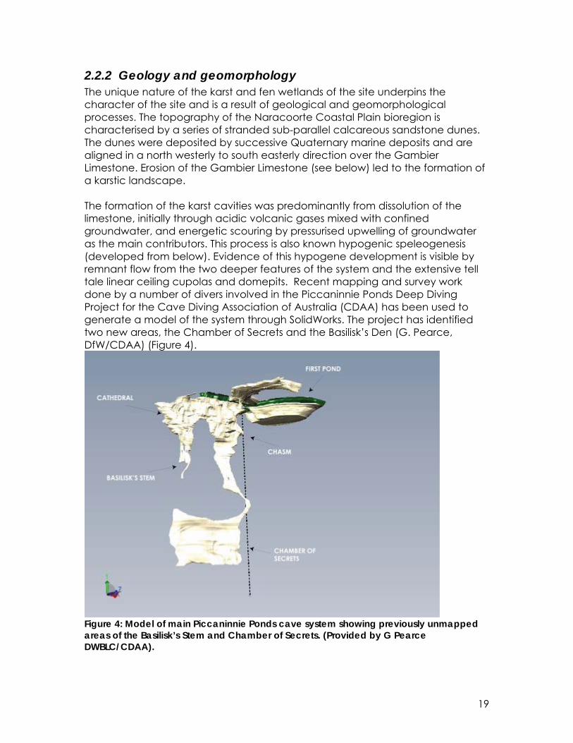
2.2.2 Geology and geomorphology The unique nature of the karst and fen wetlands of the site underpins the character of the site and is a result of geological and geomorphological processes. The topography of the Naracoorte Coastal Plain bioregion is characterised by a series of stranded sub-parallel calcareous sandstone dunes. The dunes were deposited by successive Quaternary marine deposits and are aligned in a north westerly to south easterly direction over the Gambier Limestone. Erosion of the Gambier Limestone (see below) led to the formation of a karstic landscape. The formation of the karst cavities was predominantly from dissolution of the limestone, initially through acidic volcanic gases mixed with confined groundwater, and energetic scouring by pressurised upwelling of groundwater as the main contributors. This process is also known hypogenic speleogenesis (developed from below). Evidence of this hypogene development is visible by remnant flow from the two deeper features of the system and the extensive tell tale linear ceiling cupolas and domepits. Recent mapping and survey work done by a number of divers involved in the Piccaninnie Ponds Deep Diving Project for the Cave Diving Association of Australia (CDAA) has been used to generate a model of the system through SolidWorks. The project has identified two new areas, the Chamber of Secrets and the Basilisk’s Den (G. Pearce, DfW/CDAA) (Figure 4).
Figure 4: Model of main Piccaninnie Ponds cave system showing previously unmapped areas of the Basilisk’s Stem and Chamber of Secrets. (Provided by G Pearce DWBLC/CDAA).
20
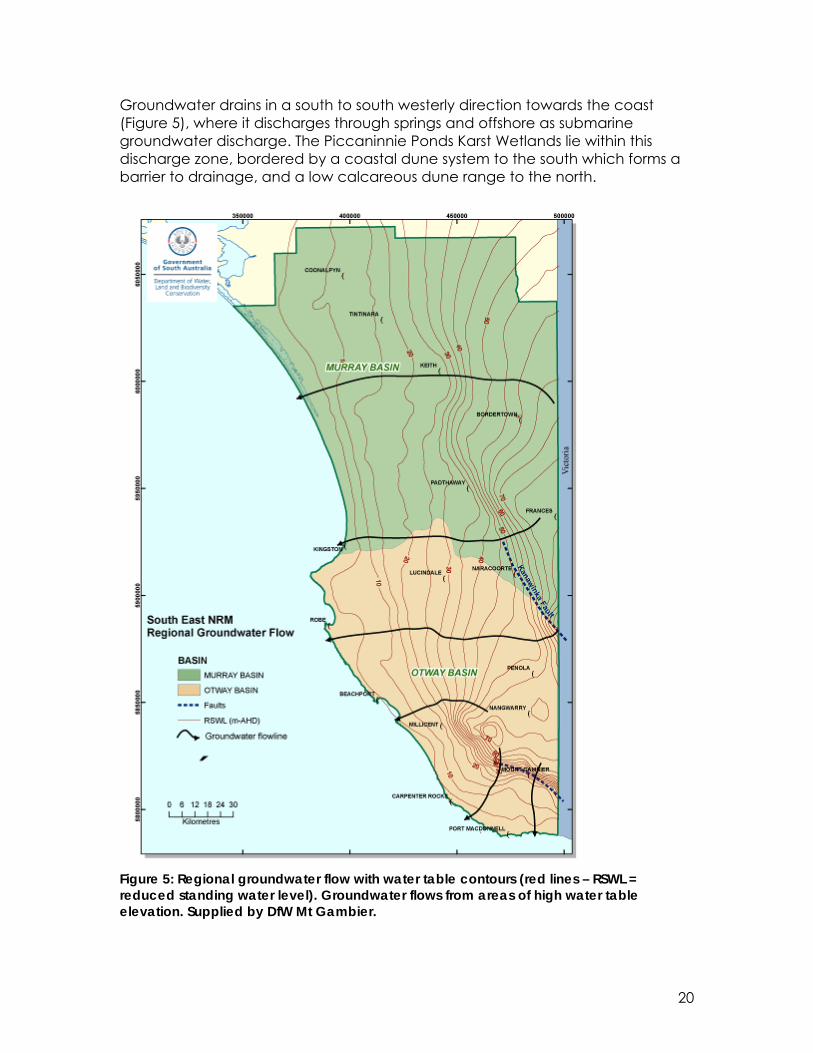
Groundwater drains in a south to south westerly direction towards the coast (Figure 5), where it discharges through springs and offshore as submarine groundwater discharge. The Piccaninnie Ponds Karst Wetlands lie within this discharge zone, bordered by a coastal dune system to the south which forms a barrier to drainage, and a low calcareous dune range to the north.
Figure 5: Regional groundwater flow with water table contours (red lines – RSWL = reduced standing water level). Groundwater flows from areas of high water table elevation. Supplied by DfW Mt Gambier.
21
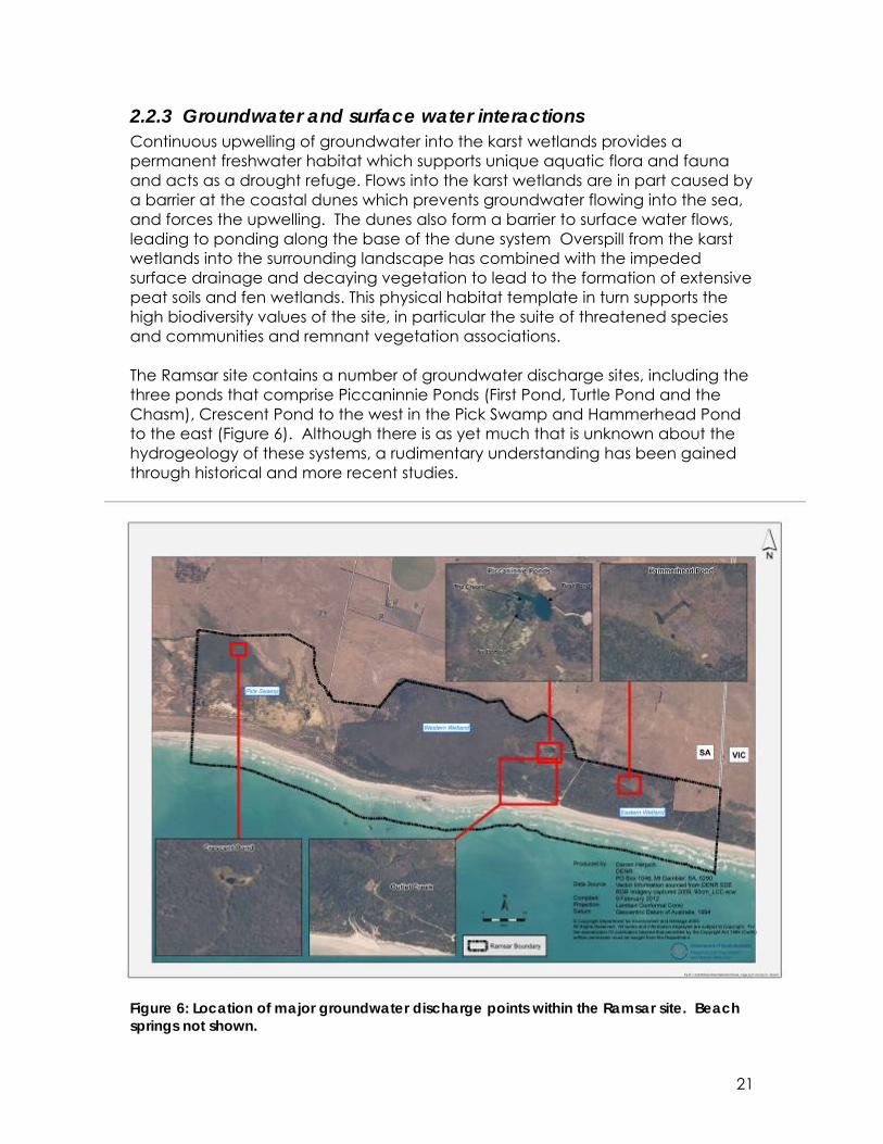
2.2.3 Groundwater and surface water interactions Continuous upwelling of groundwater into the karst wetlands provides a permanent freshwater habitat which supports unique aquatic flora and fauna and acts as a drought refuge. Flows into the karst wetlands are in part caused by a barrier at the coastal dunes which prevents groundwater flowing into the sea, and forces the upwelling. The dunes also form a barrier to surface water flows, leading to ponding along the base of the dune system Overspill from the karst wetlands into the surrounding landscape has combined with the impeded surface drainage and decaying vegetation to lead to the formation of extensive peat soils and fen wetlands. This physical habitat template in turn supports the high biodiversity values of the site, in particular the suite of threatened species and communities and remnant vegetation associations. The Ramsar site contains a number of groundwater discharge sites, including the three ponds that comprise Piccaninnie Ponds (First Pond, Turtle Pond and the Chasm), Crescent Pond to the west in the Pick Swamp and Hammerhead Pond to the east (Figure 6). Although there is as yet much that is unknown about the hydrogeology of these systems, a rudimentary understanding has been gained through historical and more recent studies.
Figure 6: Location of major groundwater discharge points within the Ramsar site. Beach springs not shown.

22
2.2.4 Peat soil formation – fen wetland creation Peat is an organic material predominantly made of dead plant material in various stages of decomposition which accumulates when there is excessive moisture (Rydin et al. 2006). Peat soil formation therefore requires two primary processes, a positive water balance and organic material accumulation (Mitsch and Gosselink 2000). Fen peatlands are formed when the primary water source is groundwater. In general fens are more alkaline and nutrient rich than bogs as their main water source is mineral rich groundwater with some surface and rainfall inputs. Initially fens start as basins dominated with open water. Water flow into and through the basin is a critical element in the formation of peat/fens. Water quality/chemistry is the other key determinant of the formation of peat and the eventual vegetation the fen wetland will support. The fen wetlands of the Piccaninnie Ponds Karst Wetlands are a result of the unique combination of topographical relief, the positioning between the barrier dune systems, the vegetation types present and most importantly the karstic landscape in which groundwater upwelling is continual.
2.2.5 Groundwater quality Water quality is considered a critical component of the ecological character of the wetland system; in particular the groundwater quality (freshness, nutrient loads, and clarity) is pivotal to supporting the submergent macrophyte and algal associations within the karst springs. The alkaline nature of the groundwater affects the formation of peat leading to the development of fen wetlands. However, there is very limited water quality information for the system, with the majority of the data from decades past and predominantly from Piccaninnie Ponds. The dominance of the surficial groundwater aquifer as a water source for the system makes the wetland vulnerable to inflows of nutrients and other chemicals from surrounding landuse activities.
2.2.6 Vegetation associations and habitat types This diversity of habitat, in the main part, is brought about by the interactions between geomorphology, hydrology and vegetation. Topographical relief, peat deposition and surface water hydrological regimes result in a mosaic of wetlands and damp soils with different depths, and durations of inundation. Water regime is the single biggest determinant of wetland vegetation, with different groups of species having different morphological adaptations to patterns of inundation. Recent floristic mapping of the site identified 30 vegetation associations (Ecological Associates 2008). Some of these associations are considered successional stages, in a transitional state due to the changing hydrological regime at Pick Swamp. These vegetation associations have been placed into

23
five broad groupings which correspond to major habitat types within the site (Table 1). Each habitat type contributes to the ecological character, either by having plant species of conservation significance or providing habitat to threatened fauna and non threatened communities. Table 1: Summary of broad vegetation groups/habitat type and dominant species Habitat type Dominant species (not necessarily in order of dominance) Aquatic community - karst
Mixed submergent species (Triglochin, Myriophyllum, Ranunculus, Nasturtium, Potamogeton) with characteristic littoral zone of emergent species (Typha, Phragmites, Eleocharis, Baumea, Juncus, Schoenus, Cyperus).
Aquatic community –fen & marsh
Mixed submergent and emergent species, herbs, grasses and sedges. Triglochin procerum, Eleocharis acuta Juncus kraussii, Typha domingensis, Epilobium billardierianum ssp., Baumea arthrophylla, Gahnia trifida.
Silky Tea Tree Tall Shrubland
Leptospermum lanigerum, Melaleuca squarrosa, Ozothamnus ferrugineus with some Leucopogon parviflorus and Acacia.
Sedgelands, rushlands and grasslands
Dominated by four main genera: Gahnia, Baumea, Typha, and Phragmites. Species include: Gahnia trifida, Ozothamunus ferrugineus, Leptospermum lanigerum, Baumea arthrophylla, Baumea juncea, Typha domingensis, Juncus kraussii,i Phragmites australis, Cladium procerum, Melaleuca squarossa.
Leucopogon shrubland Leucopogon parviflorus, Acacia longifolia var. sophorae, Olearia axillaris.
The aquatic karst community contributes significantly to the value of the site for cave diving providing spectacular growths in the crystal clear waters. The ecological value of the karst vegetation communities, however, is poorly understood. The site supports significant remnant stands of Silky Tea-Tree and Gahnia sedgelands, both of which support a wide range of threatened flora and fauna. The Crescent Pond Silky Tea-Tree habitat is one of the best remaining examples of this vegetation association in the region. Threatened species found associated with the Tea tree shrubland include the Maroon Leek-orchid (Prasophyllum frenchii), Swamp Greenhood (Pterostylis tenuissima) and Late Helmet Orchid (Corybas sp. aff. diemenicus), Yarra Pygmy Perch (Nannoperca obscura), Dwarf Galaxias (Galaxiella pusilla), Orange-bellied Parrot (Neophema chrysogaster), Rufous bristlebird (Dasyornis broadbenti), Swamp Antechinus (Antechinus minimus) and Swamp Skink (Egernia coventryi) (Bachmann 2002; Duncan et al. 2007). A full list of native plant species recorded from the Piccaninnie Ponds Karst Wetlands is presented in Appendix C.
24
2.2.7 Notable fauna and flora Nationally threatened species Piccaninnie Ponds Karst Wetlands support seven nationally or internationally threatened species. A combination of components and processes within the site combine to support these species. The ecological requirements are in some cases poorly understood, however a summary of known information is presented in Table 2. Again the critical processes that support the threatened species are the hydrological and geomorphological processes that have produced the physical habitat template. Water quality is important for the fish species as well. A full list of species of conservation significance found within the site is presented in Appendix D. Table 2: Summary of ecological requirements for nationally threatened species occurring at Piccaninnie Ponds Karst Wetlands. Australasian Bittern (Botaurus poiciloptilus) Maintenance of taxa
Inhabits inland wetlands, and occasionally, estuarine wetlands, generally where there is permanent water. Prefers wetlands with dense vegetation, including sedges, rushes and reeds. Freshwater is generally preferred, although saltmarsh vegetation in estuaries and flooded grasslands are also used by the species.
Regeneration & reproduction
Little information available regarding breeding. Breed from October to February. Nests built approximately 30cm above water level from reeds or rushes.
Yarra Pygmy Perch (Nannoperca obscura) Maintenance of taxa
Inhabits slow flowing streams and wetlands with large amounts of aquatic and surrounding vegetation. Usually found in small groups, often mixed with Southern Pygmy Perch. Will utilise drains as well.
Regeneration & reproduction
It breeds in spring, at water temperatures between 16 and 24°C.
Dwarf Galaxias (Galaxias pusilla) Maintenance of taxa
Live in slow flowing freshwater habitats in the shallows and along the margins of wetlands, drains, backwaters of streams that are overgrown with aquatic macrophytes. They may also occur in temporary waters that dry in summer but remain connected to a permanent water supply. They are capable aestivating for several months in mud and or yabby burrows if the wetland dries.
Regeneration & reproduction
Spawning occurs around August, with eggs deposited on aquatic plants, stones and leaves. Eggs hatch after approximately three weeks and are mature after approximately one year. Adults die after spawning.
Orange-bellied Parrot ( Neophema chrysogaster) Maintenance of taxa
Uses the site as a winter roosting and feeding ground during its winter migration into South Australia. Utilises the beach, shrublands and pasture areas of Pick Swamp.
Regeneration & reproduction
Not relevant to Piccaninnie Ponds Karst Wetlands

25
Maroon Leek-orchid (Prasophyllum frenchii) Maintenance of taxa
Perennial terrestrial orchid that emerges annually from an underground tuber. Grows in variety of grassland or grassy woodland habitats. Plants grow in damp soil, which is usually well drained. In Piccaninnie Ponds the orchid grows in seasonally wet/inundated grassy-sedgelands that occur over limestone pavements.
Regeneration & reproduction
Flowers between late October and December. Produces a single slender flowering spike bearing 20-60 small flowers. Flower spike to 60 cm tall. Reverts to dormancy in late February as an underground tuber, when the life-cycle is complete. Seed capsules may be produced and can be seen for several more months.
Swamp Greenhood (Pterostylis tenuissima) Maintenance of taxa
Grows exclusively in tall dense closed shrublands dominated by Leptospermum lanigerum in alkaline peat soils.
Regeneration & reproduction
Appears to be reproductively opportunistic, having been observed flowering during all months of the year.
Glenelg Spiny Crayfish (Euastacus bispinosus) Maintenance of taxa
Found in cool, flowing freshwater streams or drains with high water quality
Regeneration & reproduction
Mating occurs May/June then females carry eggs for 6 months and then the hatched larvae for a further month.
Waterbird migration, diversity and breeding Twenty migratory waterbird species have been recorded from the site, with a further 23 nomadic Australian species (listed as migratory within Australia under the EPBC Act). Migratory shorebirds in Australia are a part of the Asia-Pacific flyway. They migrate from breeding grounds in the Arctic Circle to non-breeding grounds in Australia and New Zealand, covering the journey of many thousands of kilometres in a single year. Habitat preferences of some of the migratory shorebirds are shown in Table 3. Table 3: Habitat preferences for some of the migratory shorebirds supported by the Piccaninnie Ponds Karst Wetlands (from DEW 2005).
Shorebird Breeding Area Preferred Habitat in Australia Common Greenshank
Arctic circle, Siberia
Wide variety of inland and sheltered coastal wetlands - mudflats, saltmarshes, mangroves
Curlew Sandpiper
Arctic Tundra Intertidal mudflats of sheltered coastal areas, coastal lakes, estuaries, bays and occasionally inland wetlands.
Double-banded Plover
New Zealand Littoral, estuarine and fresh or saline terrestrial wetlands, grasslands and pasture.
Red-capped plover
Mongolia, China Inland - grasslands, roost on beaches or muddy margins of terrestrial wetlands.
Latham’s Japan and Freshwater wetlands, inland, upland and

26
Shorebird Breeding Area Preferred Habitat in Australia Snipe adjacent parts of
Siberia coastal plains. Soft moist ground or shallow flooded areas.
Ruddy Turnstone
Northern Siberia, Alaska
Wide variety of habitats - generally mudflats or rocky coastline – rarely inland waters.
Sanderling High arctic regions – Alaska, Greenland, Russia
Mostly open sandy beaches.
Sharp-tailed Sandpiper
NE Siberia Muddy edges of shallow fresh or brackish water. Common on both intertidal and inland waters.
The Orange-bellied Parrot (Neophema chrysogaster) utilises the site as a part of its winter migration into South Australia, and it is likely that all the birds that move into South Australia pass through the site. The Piccaninnie Ponds Karst Wetlands do not support large aggregations (>20,000) of waterbirds, but the site does support a significant number of species when compared to larger wetlands within the bioregion. The range of habitats present supports 73 species of waterbirds and 20 migratory species, however with increased survey work this is likely to increase. The presence of permanent water at the site supports its importance as a refuge area for migratory and nomadic waterbird species when other parts of South Eastern Australia are experiencing dry conditions. Five species of waterbirds have been recorded breeding at the site. This number is expected to rise as the restoration of the hydrological regime at Pick Swamp continues. Breeding stimuli for Black Swans and Brolga is flooding, and their breeding on site is likely a response to the changed water regime within Pick Swamp. Australian Shelduck and Masked Lapwing have also been recorded breeding in the wetlands and Hooded Plover have been recorded breeding on the beach. The critical components and processes which support the waterbirds are the habitat complexity and food resources, which in turn is created by the combination of hydrological and geomorphological process and the ecological response of the vegetation. Fish diversity, migration and breeding Seven of the ten native fish species supported by Piccaninnie Ponds Karst Wetlands are diadromous, migrating between the freshwater wetlands and the marine environment at some stage of their life cycle. The upwelling groundwater and subsequent overflow into Outlet Creek maintains the hydrological connection with the sea, thus sustaining this service. The key habitat features that support the fish populations within the Piccaninnie Ponds Karst Wetlands include the hydrological connection to the sea via Outlet

27
Creek, the permanent water supplied by the groundwater upwelling, and the dense vegetation and good water quality. All of these interact to provide excellent habitat and conditions which support 10 of the 15 native fish species found in the region. Of particular importance is the connectivity to the sea, which allows a number of diadromous fish to use the system.
2.3 Ecological character of the Piccaninnie Ponds Karst Wetlands The maintenance of the ecological character of the Piccaninnie Ponds Karst Wetlands is the central premise of this management plan. The following is a summary of the Ramsar criteria which the site meets, and the primary determinants of the ecological character. These are the components and processes which support the services for which the site was nominated, being those which if adversely impacted could lead to a change in ecological character. The information presented in this section is extracted from the Ecological Character Description (ECD) (Butcher et al. 2011), which should be referred to for more detail on the ecological services, components and processes and how these interact.
2.3.1 Ramsar criteria justification and wetland types The Piccaninnie Ponds Karst Wetlands meets five of the nine Ramsar criteria for listing as a Wetland of International Importance: Criterion 1: The site represents an outstanding example of two rare wetland
types within the South East Coast Drainage Division. Karst and other subterranean hydrological systems have a range of conservation and cultural values and are recognised as being globally important. Fen wetlands are one of the most vulnerable wetland types being highly susceptible to degradation. The Piccaninnie Ponds Karst Wetlands is a unique combination of karst and coastal fen wetlands in good condition. The site includes a series of rising spring karst systems as well as several substantial groundwater beach springs along the foreshore of the beach. The continual discharge of groundwater has led to the water logging of soils and the formation of extensive peatland fens.
Criterion 2: The site supports seven nationally or internationally listed species
of conservation significance including: Australasian bittern (Botaurus poiciloptilus), orange-bellied parrot (Neophema chrysogaster), Yarra pygmy perch (Nannoperca obscura), dwarf galaxias (Galaxiella pusilla), Glenelg spiny freshwater crayfish (Euastacus bispinosus), swamp greenhood (Pterostylis tenuissima) and the maroon leek-orchid (Prasophyllum frenchii).

28
Criterion 3: The site is a unique karst wetland system which provides habitat for an extensive and diverse assemblage of endangered, rare and other flora and fauna, highly representative of the pre-European biodiversity of the Lower Limestone Coast region of South Australia. The karst wetland system on which this biodiversity is dependent, is rare within the bioregion, and represents one of the few remaining areas of permanent freshwater in the South East of South Australia. The biota of the subterranean areas of the karst wetlands are believed to be significant and contribute a unique element to the regional biodiversity. The site falls within a national biodiversity ‘hotspot’. The site is species rich supporting similar or greater numbers of waterbirds compared to larger nearby coastal wetlands and Bool and Hacks Lagoons Ramsar site to the north of Mount Gambier. Over 30 floral associations and 250 plant species have been recorded from the site, a number of which are used by six butterfly species which are of conservation concern.
Criterion 4: The site is a known winter roosting and feeding location for the
Critically Endangered orange-bellied parrot (Neophema chrysogaster). The site also provides habitat for 79 waterbird species including 25 species listed under international agreements: CAMBA (20), JAMBA (20), ROKAMBA (15), BONN (16) and 26 Australian migratory or marine species. Native fish populations include seven species which are diadromous and three freshwater obligate species which rely on permanent freshwater. This site represents one of the few remaining permanent freshwater wetlands in the lower South East of South Australia and is believed to be a drought refuge.
Criterion 8: The site is an important spawning ground for the Yarra pygmy
perch (Nannoperca obscura) and dwarf galaxias (Galaxiella pusilla) in South Australia. Despite the karst system being relatively isolated, this system supports species that spawn both within the freshwater wetlands as well as in the nearby marine environment including spotted galaxias (Galaxias truttaceus), climbing galaxias (Galaxias brevipinnis) and pouched lamprey (Geotria australis).
2.3.2 Ramsar wetland types Under the Ramsar Convention’s classification system hydrological regime, substrate and vegetation are used to describe wetland types. Piccaninnie Ponds Karst Wetlands have six natural and one artificial wetland type under the Ramsar wetland classification system as follows:
Inland wetlands • Karst and other subterranean hydrological systems (type Zk(b). • Permanent freshwater marshes/pools; ponds (below 8 ha), marshes and
swamps on inorganic soils; with emergent vegetation water-logged for at least most of the growing season (type Tp).

29
• Seasonal/intermittent freshwater marshes/pools on inorganic soils; includes sloughs, potholes, seasonally flooded meadows, sedge marshes (type Ts).
• Non-forested peatlands; includes shrub or open bogs, swamps, fens (type U).
• Shrub-dominated wetlands; shrub swamps, shrub-dominated freshwater marshes, shrub carr, alder thicket on inorganic soils (type W).
Marine/Coastal wetlands • Sand, shingle or pebble shores; includes sand bars, spits and sandy islets;
includes dune systems and humid dune slacks (type E).
Human made wetlands • Canals and drainage channels, ditches (referred to hereafter as drains)
(type 9).
2.3.3 Critical components and processes Critical components and processes are those that are central to maintaining the ecological character of a Ramsar site. In the context of the Piccaninnie Ponds Karst Wetlands these include the characteristics of the wetland that are crucial to the maintenance of the ecological services for which the site has been nominated. The linkages between components, processes, benefits and services and the criteria under which the site was listed are illustrated conceptually in Figure 7. This simple conceptual model for the Piccaninnie Ponds Karst Wetlands site shows not only the components, processes and services that are critical to the ecological character of the site, but also the essential elements which are important in supporting the critical components, processes and services the site provides.

30
Figure 7: Simple conceptual model of critical and essential components, processes and services for Piccaninnie Ponds Karst Wetlands The critical components and processes for the Piccaninnie Ponds Karst Wetlands are:
• Hydrology; • Water quality; • Vegetation communities; • Fish; and • Waterbirds.
Table 4: Summary of critical components and processes within Piccaninnie Ponds Karst Wetlands. Component / process
Description
Hydrology Continual groundwater discharge into the Main Ponds, Hammerhead Pond, Crescent Pond and several unnamed springs inundate surface areas and lead to waterlogged soils. Outlet Creek discharges to the sea and provides a connection to the marine environment for several diadromous fish species. In the Main Ponds discharge is predominantly from the Chasm with evidence of greater inflows at approximately 36 metres depth due to fractures in the limestone. Sea water intrusion occurs in the Chasm

31
as well. Water quality Salinity is variable across the site. Main Ponds is consistently
more saline than Outlet Creek at the weir. Nitrogen levels are high with a possible trend of gradual increase in nitrate levels over the past several decades. Nitrate levels are highest in areas with direct groundwater discharge. Phosphorous levels are low across the site. Turbidity is uniformly low in the karst wetlands, with clarity of the water a distinctive feature of the site. pH tends slightly alkaline.
Vegetation Key associations include silky tea tree shrubland, karst aquatic communities, sedgeland, rushland and grassland and the fen and marsh aquatic communities. Diversity is high with over 30 associations mapped and 250 species identified.
Fish Ten native fish species are recorded from the site. Historical records suggest an additional two species may have been present. No introduced species are present within the system. The species present have a range of migration strategies some of which rely on connectivity to the Southern Ocean.
Waterbirds Supports 79 species including 25 species which are migratory. It is a key site for roosting and feeding for orange-bellied parrot during its winter migration. Shorebirds utilise the beach area and are also often encountered in Pick Swamp. There are limited records for sea birds. Diversity is high compared to larger nearby wetland complexes.
2.3.4 Essential components and processes The essential components and processes that are considered important in supporting the critical components, processes, and services of the Piccaninnie Ponds Karst Wetlands are described briefly below. Table 5: Summary of supporting components and processes within Piccaninnie Ponds Karst Wetlands. Component /
process Description
Climate Stable mediterranean climate with warm dry summers and cool wet winters. Annual rainfall is approximately 700 millimetres per year with low interannual variation.
Geomorphic setting
One of two coastal karst regions in south east of South Australia. The formation of the karstic cavities allowed upwelling of groundwater which in turn supplies water to the surrounding wetlands. The site lies in a closed

32
catchment with little sedimentation or erosional activity, with dissolution of the limestone the main geomorphic process. The main karst discharge points are Crescent Pond, Piccaninnie Ponds, Hammerhead Pond and several smaller springs. Piccaninnie Ponds is believed to have two discharge points. Fifteen beach springs have been identified along the foreshore of the site.
Soils Six soils types are present within the site; however peat soils are a key feature of the site. Three types of peat have been identified within the immediate vicinity of the Main Ponds.
Algae Phytoplankton growth is limited in the Main Ponds as the flushing rates and low phosphorous preclude establishment of phytoplankton communities. This in turn limits the establishment of zooplankton (Scholz 1987; Thurgate 1995). Macrophytes within the karst wetlands support significant amounts of periphyton which is believed to be important in the food webs of the karst wetlands. Epiphytic and benthic algae are distinctive features of the aquatic vegetation in the Main Ponds.
Invertebrates Very limited data is available for the aquatic invertebrate communities of the Piccaninnie Ponds Karst Wetlands and this is considered a significant knowledge gap. Flushing rates in the Main Ponds may limit phytoplankton communities. Pick Swamp is known to support the endangered Glenelg spiny freshwater crayfish.
2.4 Social and cultural values of the Piccaninnie Ponds Karst Wetlands
2.4.1 Recreation and tourism A mixture of passive and active recreation and tourism activities are undertaken at Piccaninnie Ponds Karst Wetlands, including:
• Bird watching and sightseeing, • Walking on boardwalks and walking trail, • Diving and snorkelling at Piccaninnie Ponds, • Picnics and barbeques • Beach Fishing, and • Camping.
The activities listed above are generally undertaken by day visitors and short-term campers. Visitor facilities are located at the Main Ponds area at Piccaninnie

33
Ponds, which along with the boardwalk and foreshore is the main area of visitation. The current management plan for the Piccaninnie Ponds Conservation Park (DEP 1992) contains policies and actions that seek to achieve the following objectives:
• Provide recreation and tourism opportunities consistent with the protection of ecosystem and amenity values of the site;
• Control access so that visitors are constrained to designated visitor and camping areas and amenities;
• Provide education materials and opportunities to encourage community awareness, appreciation and protection of the site;
• Ensure that access tracks, walking paths, boardwalks and camping areas are maintained in good condition and that vehicular and foot traffic does not affect the overall condition of the site.
While the current management plan was prepared for Piccaninnie Ponds, the objectives listed above will also be relevant to Pick Swamp.
2.4.2 Cultural values Piccaninnie Ponds and Pick Swamp are part of the traditional lands of the Boandik (also known as Bunganditj) and local indigenous people. These people and their lands are one, thus the cultural and spiritual values are ingrained in all ecological components and processes, past, present and future. The wetlands were an important area for gathering and hunting of food including both aquatic species such as ducks and fish as well as terrestrial species that were attracted to the freshwater reserves. The wetlands were important areas for trading with other indigenous peoples. The “puddings”, earthen and limestone mounds on the land-ward side of Pick Swamp, were important sites for Men’s business, in particular the caves were used for initiation ceremonies. Evidence of stone huts on the ocean side of Pick Swamp and middens along the coast indicate occupancy. The high level of connectivity between the wetlands and the more terrestrial vegetation is considered important. There is evidence of trees near Crescent Pond having been used for smoking eels that were traded for food and fibre that was not found in the Boandik’s country.
3 Land tenure, management and planning context
3.1 Land tenure Piccaninnie Ponds was proclaimed as a Conservation Park in 1976, with the Pick Swamp and Lapatha additions proclaimed in 2011, under the National Parks and Wildlife Act 1972. Conservation Parks are proclaimed for the purpose of conserving any wildlife or the natural or historic features of the land,. The Ramsar site includes the entirety of the Conservation Park, including the adjoining beach areas to the mean low tide mark..

34
3.2 Management and planning context The Piccaninnie Ponds Conservation Park is currently managed within the context of a number of national, State and regional NRM policy and strategy initiatives. Both the current management arrangements and those proposed in this plan provide the basis for meeting future objectives for the Piccaninnie Ponds Conservation Park within an adaptive management framework.
3.2.1 Ramsar Convention and EPBC Act 1999 See section 1.2 and Appendix A.
3.2.2 Native title Native Title describes the rights and interests Aboriginal and Torres Strait Islander People have in land and waters according to their traditional laws and customs. Commonwealth legislation, in the form of the Native Title Act 1993 was enacted to:
• Provide for the recognition and protection of native title; • Establish ways in which future dealings affecting native title may proceed
and to set standards for those dealings; • Establish a mechanism for determining claims to native title; and • Provide for, or permit, the validation of past acts, and intermediate period
acts, invalidated because of the existence of native title. This management plan is released and will be adopted subject to any native title rights and interests that may continue to exist in relation to the land and/or waters. Before undertaking any acts that might affect native title, DENR will follow the relevant provisions of the Native Title Act 1993.
3.2.3 Other notable national strategies and legislation Other important national strategies and legislation that confer protection of values associated with systems such as the Piccaninnie Ponds Karst Wetlands include (listed chronologically):
• National Framework for Management and Monitoring of Australia's Native Vegetation (2001) (http://www.environment.gov.au/land/publications/nvf/index.html);
• Australia’s Biodiversity Conservation Strategy (2010-2030) (http://www.environment.gov.au/biodiversity/publications/strategy-2010-30/index.html);
• National Action Plan for Salinity & Water Quality (2000) (http://www.napswq.gov.au/publications/index.html);
• The Native Title Act (1993) (http://www.austlii.edu.au/au/legis/cth/consol_act/nta1993147/);
• The National Water Quality Management Strategy (1992) (http://www.environment.gov.au/water/quality/nwqms/).

35
3.2.4 State and regional legislation, strategies and plans National Parks and Wildlife Act 1972 The National Parks and Wildlife Act (1972) provides for the proclamation and management of reserves and sanctuaries in South Australia. Under the Act, the Minister for Environment and Conservation is the controlling authority for reserves and the Director of National Parks and Wildlife is responsible for reserve management. Under section 36, the Director must observe any direction from the Minister or the Chief Executive of the Department for Environment and Natural Resources (DENR) in relation to management of reserves in general or any particular reserve. Management of reserves must have regard to the objectives contained in the Act, which include (section 37):
• the preservation and management of wildlife; • the preservation of historic sites, objects and structures of historic or
scientific interest within reserves; • the preservation of features of geographical, natural or scenic interest; • the destruction of dangerous weeds and the eradication or control of
noxious weeds; • the control of vermin and exotic animals; and • the control and eradication of disease of animals and vegetation; • the prevention and suppression of bush fires and other hazards; • the encouragement of public use and enjoyment of reserves and
education in, and a proper understanding and recognition of, their purpose and significance;
• generally the promotion of the public interest; and • the preservation and protection of Aboriginal sites, features, objects and
structures of spiritual or cultural significance within reserves. The National Parks and Wildlife Act (section 38) stipulates that a management plan must be developed for each reserve and a management plan must be prepared as soon as practicable after the constitution of a reserve. Under the Act 1 a management plan "must set forth proposals of the Minister in relation to the management and improvement of the reserve" and "set forth any other proposals by which the Minister proposes to accomplish the objectives of the Act in relation to the reserve". In addition, once the Minister has adopted a management plan, the provisions of the plan must be carried out in relation to that reserve and operations must not be undertaken in relation to that reserve unless the operations are in accordance with the management plan.

36
3.2.5 Other notable state strategies and legislation A significant body of State and regional legislation, NRM strategies and plans are relevant to or have the potential to affect the management of the Piccaninnie Ponds Karst Wetlands, including (listed chronologically):
• No Species Loss - A Nature Conservation Strategy for South Australia 2007-2017. State nature conservation strategy (2007)
• The Fisheries Management Act (2007) (http://www.austlii.edu.au/au/legis/sa/consol_act/fma2007193.txt)
• The South Australian State Natural Resources Management (NRM) Plan (2006) (http://www.nrm.sa.gov.au/SAStateNRMPlan/tabid/1356/Default.aspx)
• Fire and Emergency Services Act (2005) (http://www.austlii.edu.au/au/legis/sa/consol_act/faesa2005249.txt)
• The South East Natural Resources Management Plan (2004) • The Natural Resources Management Act (2004)
(http://www.nrm.sa.gov.au/TopNav/NRMLegislation.aspx ) • The Wetlands Strategy for South Australia (DENR & DFW 2003) • NatureLinks: Implementing the WildCountry philosophy in South Australia
(2002) (http://www.environment.sa.gov.au/naturelinks/) • Petroleum Act (2000)
(http://www.austlii.edu.au/au/legis/sa/consol_act/pa2000137.txt) • Biodiversity Plan for the South East of South Australia (1999) • Local Government Act (1999)
(http://www.austlii.edu.au/au/legis/sa/consol_act/lga1999182.txt) • The Environment Protection Act (1993)
(http://www.austlii.edu.au/au/legis/sa/consol_act/epa1993284.txt) • The Development Act (1993)
(http://www.austlii.edu.au/au/legis/sa/consol_act/da1993141.txt) • The South Eastern Water Conservation and Drainage Act (1992)
(http://www.austlii.edu.au/au/legis/sa/consol_act/sewcada1992446/) • The Native Vegetation Act (1991)
(http://www.legislation.sa.gov.au/LZ/C/A/NATIVE%20VEGETATION%20ACT%201991.aspx)
• The Aboriginal Heritage Act (1988) (http://www.austlii.edu.au/au/legis/sa/consol_act/aha1988164.txt)
• The Coast Protection Act (1972) (http://www.austlii.edu.au/au/legis/sa/consol_act/cpa1972199.txt)
• The Mining Act (1971) (http://www.austlii.edu.au/au/legis/sa/consol_act/ma197181.txt)
• Road Traffic Act (1961) (http://www.legislation.sa.gov.au/LZ/C/A/ROAD%20TRAFFIC%20ACT%201961.aspx)
• Groundwater (Border Agreement) Act (1985) http://www.austlii.edu.au/au/legis/sa/consol_act/gaa1985291/

37
3.2.6 Regional planning The following regional plans are notable in this context and those implementing them, and this plan, will need to collaborate closely to ensure complementarity.
• Biodiversity Plan for South East of South Australia – Croft et al. (1999); • South East Natural Resources Management Plan which is being
developed, to be implemented by 2009-2010. Currently the South East NRM Board operates under the initial NRM Plan (2006), which is a statutory document http://www.senrm.sa.gov.au/LinkClick.aspx?fileticket=plVV6av9JcQ%3d&tabid=612&mid=2466;
• South East Drainage Board Management Plan 2002-2006; • South East Catchment Water Management Plan 2003-2008. This and other
regional plans are now implemented through the South East NRM Plan; • Limestone Coast Water Allocation Plan*; • Borders Agreement (South Australia and Victoria); • Piccaninnie Ponds Conservation Park Management Plan.
* Important regional planning relevant to the Ramsar listing of the Piccaninnie Ponds Karst Wetlands includes the development and finalisation of water sharing plans. The system is in the area covered by the Comaum-Caroline water allocation plan (WAP) (SECWMB 2001), which is currently being revised and combined with the WAPs for Lacepede-Kongorong and Naracoorte Ranges into a single new WAP for the Lower Limestone Coast Prescribed Wells Area.
38
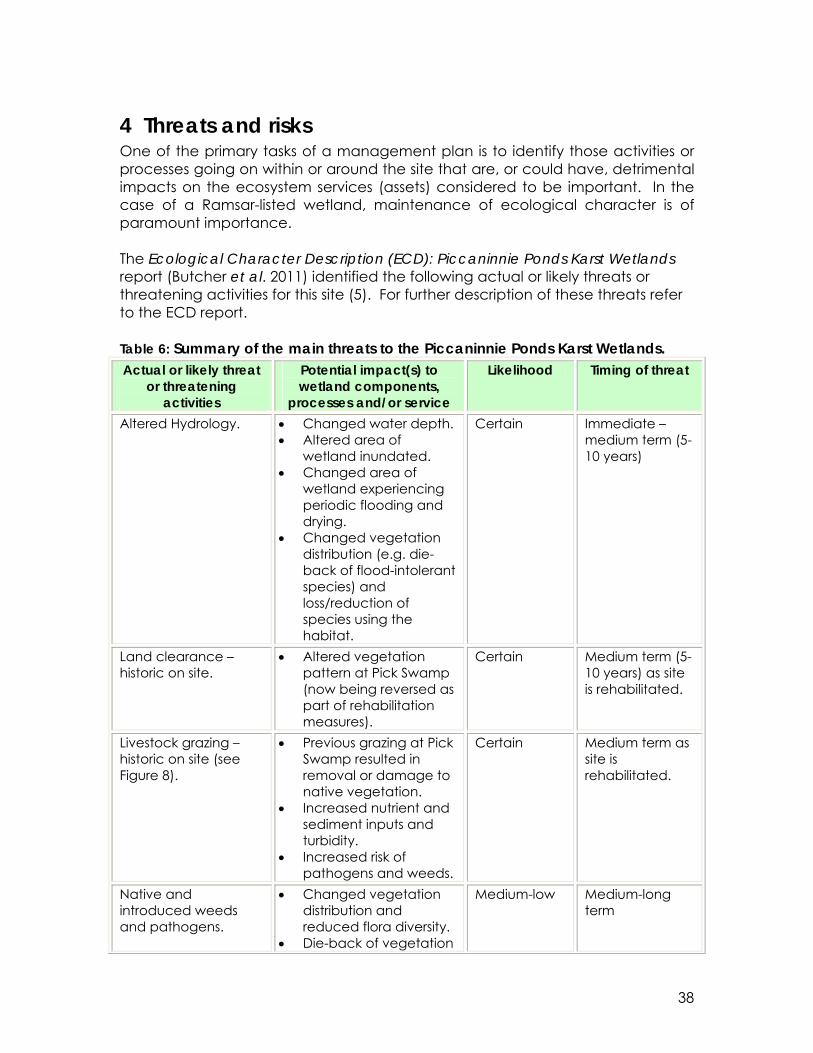
4 Threats and risks One of the primary tasks of a management plan is to identify those activities or processes going on within or around the site that are, or could have, detrimental impacts on the ecosystem services (assets) considered to be important. In the case of a Ramsar-listed wetland, maintenance of ecological character is of paramount importance. The Ecological Character Description (ECD): Piccaninnie Ponds Karst Wetlands report (Butcher et al. 2011) identified the following actual or likely threats or threatening activities for this site (5). For further description of these threats refer to the ECD report. Table 6: Summary of the main threats to the Piccaninnie Ponds Karst Wetlands. Actual or likely threat
or threatening activities
Potential impact(s) to wetland components,
processes and/or service
Likelihood Timing of threat
Altered Hydrology. • Changed water depth. • Altered area of
wetland inundated. • Changed area of
wetland experiencing periodic flooding and drying.
• Changed vegetation distribution (e.g. die-back of flood-intolerant species) and loss/reduction of species using the habitat.
Certain Immediate – medium term (5-10 years)
Land clearance – historic on site.
• Altered vegetation pattern at Pick Swamp (now being reversed as part of rehabilitation measures).
Certain Medium term (5-10 years) as site is rehabilitated.
Livestock grazing – historic on site (see Figure 8).
• Previous grazing at Pick Swamp resulted in removal or damage to native vegetation.
• Increased nutrient and sediment inputs and turbidity.
• Increased risk of pathogens and weeds.
Certain Medium term as site is rehabilitated.
Native and introduced weeds and pathogens.
• Changed vegetation distribution and reduced flora diversity.
• Die-back of vegetation
Medium-low Medium-long term

39
Actual or likely threat or threatening
activities
Potential impact(s) to wetland components,
processes and/or service
Likelihood Timing of threat
(aquatic, emergent, terrestrial).
Water quality impact of historic discharge of wastewater to regional groundwater
• Increased nutrient concentration in groundwater recharge.
To be confirmed
Medium-long term, depending on regional groundwater hydrology.
Tourism and recreation
• Damage to wetland vegetation and site infrastructure.
• Increased risk of introduced weeds and pathogens.
Low with current management arrangements in place
Long term (ongoing)
Aquatic vegetation die-back
• Altered aquatic vegetation patterns.
Unknown as cause of previous events has not been established
Climate change resulting in: • Increased
temperature • Increased
frequency of extreme events
• Decreased rainfall runoff
• Increased risk of wildfire
• Altered hydrological regime (e.g. recharge rates, rainfall-runoff, rate of drying).
• Altered flora and fauna distribution.
• Reduced habitat condition.
Medium Medium-long term.
Wildfire • Loss of vegetation cover.
• Changed vegetation patterns.
• Loss of peat and stored carbon.
• Loss of fossil pollen record.
• Increased contaminant load in runoff.
• Reduced habitat condition.
Low Long term (ongoing).

40
Figure 8: Grazing and land clearing impact at Pick Swamp (left of fence line) compared to reserve area of Piccaninnie Ponds Conservation Park (right of fence line). Image taken in 2006.
5 Management strategies and actions Section 1.4 set out the management objectives for this site under four themes, as reproduced in the following sections. These themes align with the vision for this plan and the strategies and actions outlined below seek to protect or improve the ecological character and protect and preserve the social and cultural assets and values associated with the wetland. In order to apply an adaptive management approach monitoring of the outcomes associated with these actions is necessary and this described in the ecological strategies and actions as well as in section 6.
5.1 Ecological management
5.1.1Ecological management objectives

41
• Maintain, enhance and restore the globally recognised ecological and biological assets of the site; and
• Reinstate hydrological regime and connectivity across the site.
5.1.2 Ecological management strategies The ecological management objectives (see above) seek to protect the ecological character and ecosystem functions of the Piccaninnie Ponds section of the wetland, to rehabilitate the Pick Swamp section, and to integrate both sections into a single management unit over time. To achieve these objectives the following strategies will be pursued:
1. Reinstatement of a more natural hydrological regime and connectivity across the site in order to maintain or improve the ecological character and habitat diversity of the system.
2. Development and implementation of an ecological monitoring program
that will inform integrated wetland management in the future. This will include monitoring of hydrology and water quality.
3. Protection of threatened species and/or ecological communities and
their habitat.
4. Protection of populations of species important for maintaining the biological diversity of the region.
5. Protection of species at a critical stage in their life cycles, or refugia during adverse conditions.
6. Protection of spawning ground, nursery and/or migration path and food sources on which fish stocks, either within the wetland or elsewhere, depend.
7. Management of Piccaninnie Ponds and Pick Swamp as a single system.
8. Revegetation by allowing native vegetation (species and associations) to
recolonise suitable areas within the property, supplemented by replanting and direct seeding, as necessary.
9. Control of weeds by eliminating noxious species and controlling as far as is practicable introduced plant species that threaten ecological character.
10. Control of introduced fauna as far as is practicable.

42
5.1.3 Ecological management actions While the emphasis at Piccaninnie Ponds is on conservation and preservation of existing values and assets, the emphasis at Pick Swamp (at least in the short term) will be on wetland rehabilitation. This requires a mixture of management strategies related to both passive and active rehabilitation, with the actions supplementing, and where appropriate referring to, the rehabilitation strategies and actions as detailed in Clarke (2007). Management actions to implement the strategies listed above, and to address the threats identified in section 4 are provided below in Table 7.
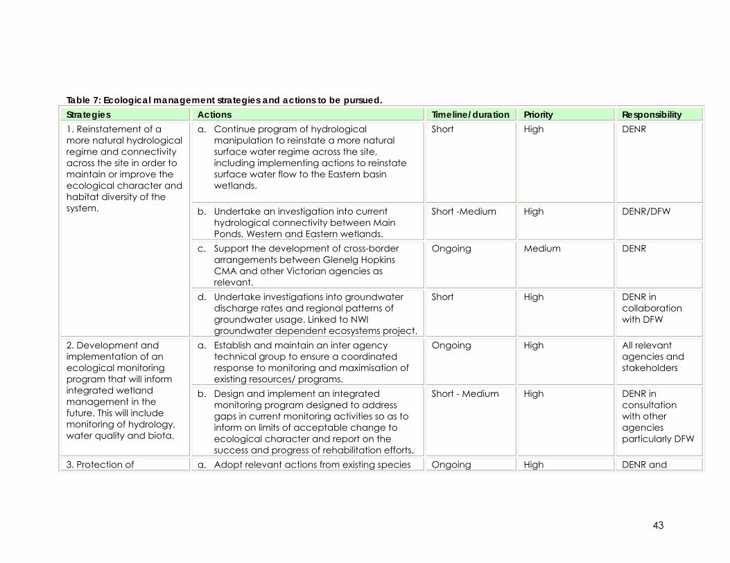
43
Table 7: Ecological management strategies and actions to be pursued. Strategies Actions Timeline/duration Priority Responsibility
a. Continue program of hydrological manipulation to reinstate a more natural surface water regime across the site, including implementing actions to reinstate surface water flow to the Eastern basin wetlands.
Short High DENR
b. Undertake an investigation into current hydrological connectivity between Main Ponds, Western and Eastern wetlands.
Short -Medium High DENR/DFW
c. Support the development of cross-border arrangements between Glenelg Hopkins CMA and other Victorian agencies as relevant.
Ongoing Medium DENR
1. Reinstatement of a more natural hydrological regime and connectivity across the site in order to maintain or improve the ecological character and habitat diversity of the system.
d. Undertake investigations into groundwater discharge rates and regional patterns of groundwater usage. Linked to NWI groundwater dependent ecosystems project.
Short High DENR in collaboration with DFW
a. Establish and maintain an inter agency technical group to ensure a coordinated response to monitoring and maximisation of existing resources/ programs.
Ongoing High All relevant agencies and stakeholders
2. Development and implementation of an ecological monitoring program that will inform integrated wetland management in the future. This will include monitoring of hydrology, water quality and biota.
b. Design and implement an integrated monitoring program designed to address gaps in current monitoring activities so as to inform on limits of acceptable change to ecological character and report on the success and progress of rehabilitation efforts.
Short - Medium High DENR in consultation with other agencies particularly DFW
3. Protection of a. Adopt relevant actions from existing species Ongoing High DENR and

44
Strategies Actions Timeline/duration Priority Responsibility recovery plans as available. relevant
agencies b. Establish condition of Silky Tea Tree
communities and other significant vegetation communities. Develop and implement relevant management strategies to maintain or improve condition based on findings.
Short - Long High DENR
c. Manage hydrology, water quality and vegetation to ensure adequate habitat to maintain and where appropriate enhance threatened species.
Ongoing High DENR
threatened species and/or ecological communities and their habitat.
d. Establish patterns of habitat usage by listed species.
Short - Medium Medium DENR
a. Protect stands of remnant indigenous vegetation (e.g. maintain fencing to exclude livestock access from neighbouring properties).
Ongoing Low DENR 4. Protection of populations of species important for maintaining the biological diversity of the region. b. See also ecological management Strategies
1, 9 and 10 (this Table) for relevant actions for rehabilitation of hydrology, weed control and vertebrate pest control.
Ongoing Medium DENR
a. Management of access to the site to minimise disturbance of fauna during critical life stages, such as migration and breeding. This includes consideration of vehicular and walking track access. See also Table 6 recreational and landuse management Strategy 2.
Ongoing Low DENR
b. Implement vertebrate pest management actions as per strategy 10.
Ongoing Low DENR
5. Protection of species at a critical stage in their life cycles, or refugia during adverse conditions.
c. Maintain required habitat. Ongoing Medium DENR

45
Strategies Actions Timeline/duration Priority Responsibility a. Maintain hydrological connectivity via Outlet
Creek to the Southern Ocean to allow diadromous fish to migrate.
Ongoing High DENR
b. Maintain surface water quality to protect native fish.
Ongoing High DENR
6. Protection of spawning ground, nursery and/or migration path and food sources on which fish stocks, either within the wetland or elsewhere, depend. c. Ensure range of habitats available including
access to well vegetated inundated areas and permanent water as drought refuge.
Ongoing High DENR
7. Management of Piccaninnie Ponds and Pick Swamp as a single system.
a. Develop and implement a fire management plan for the whole site, coordinated with the Regional Fire Plan.
Short Medium DENR
8. Revegetation by allowing native vegetation (species and associations) to recolonise suitable areas within the property, supplemented by replanting and direct seeding, as necessary.
a. Undertake direct seeding and revegetation actions in selected areas as per Clarke 2007.
Short - Medium Medium DENR
a. Develop and implement pest and invasive species management plans for the site.
Ongoing Medium DENR 9. Control of weeds by eliminating noxious species and controlling as far as is practicable all the introduced plant species that threaten ecological character.
b. Undertake weed eradication and control activities at Pick Swamp as detailed in Clarke 2007.
Short Medium
10. Control of introduced fauna as far as is practicable.
a. Develop a strategy to address potential exotic fish invasion.
Long Low DENR
46
5.2 Recreational and landuse management
5.2.1 Recreational and surrounding landuse objectives
• Manage visitor access and facilities consistent with Ramsar principles of wise use to maintain the ecological character of the site; and
• Promote the Piccaninnie Ponds Karst Wetlands as an internationally important wetland within the lower South East region;
• Work with surrounding landholders to assist them in minimising impacts on
the Ramsar area, and to promote rehabilitation of adjoining habitat areas; and
• Manage fire to ensure the protection of life and property, the
maintenance of the ecological character of the site, and the protection of cultural values.
5.2.2 Recreational and landuse management strategies Arrangements are in place to manage visitor access and impact around Piccaninnie Ponds (DEP 1992). Access to Piccaninnie Ponds is via a single road from the entrance to the site. Parking of vehicles is in designated areas, as is camping, and the public are limited to designated tracks in and around the site. Visitor facilities are centred on the Main Ponds area. In addition, there is a permit system for those visitors seeking to snorkel or dive at Piccaninnie Ponds. The permit system, administered by DENR, allocates visitors to designated time slots and limits the number of people who may enter the ponds at any one time. In short, the management of visitor access to and use of Piccaninnie Ponds is in place and should be continued in the future. As Pick Swamp has only recently been added to the conservation park, the site does not have a history of public use, as does Piccaninnie Ponds. A rehabilitation plan for Pick Swamp (Clarke 2007) identifies different management zones (based primarily on vegetation patterns), objectives and actions required for ecological rehabilitation at the wetland. However, the vision for how Pick Swamp may be used by visitors in the short to medium term is not clear, with discussions underway to clarify the future use of the site. It is recommended that the DENR consider planning for recreation and tourism issues at this site. Fire management Under the National Parks and Wildlife Act 1972, reserve management must give regard to the prevention and suppression of bush fires and other hazards. Fire

47
management in reserves is based on objectives and policy contained in the DENR Fire Management Policy and reserve-specific fire management plans. Fire management plans are a requirement of the Country Fires Act 1989. They are developed in conjunction with adjoining Country Fire Service Groups, regional and district Bushfire Prevention Committees, to integrate district fire management. Stakeholders and the wider community are also consulted to ensure an understanding of the fire risks and mitigating actions being proposed or undertaken in the reserve. Fire management planning will:
• identify natural and cultural heritage values and built assets; • provide a framework for the management of bushfire suppression,
including identification of strategic access and control lines; • provide a framework for prescribed burning for ecological management
and fuel reduction purposes; and • identify performance indicators.
A regional fire plan exists which currently includes Piccaninnie Ponds Conservation Park. The recreational and landuse management objectives (see above) seek to protect the ecological character and ecosystem functions of the Piccaninnie Ponds section of the wetland by adopting a wise use approach to management of the site. In order to meet these objectives the following strategies will be pursued:
1. Provide and maintain access to key areas of the site so as to maintain the ecological character of the site whilst promoting recreational activities.
2. Protect and enhance ecological and cultural values (including
indigenous peoples’ values).
3. Promote the Piccaninnie Ponds Karst Wetlands an internationally important wetland within the lower South East region.
4. Provide a safe environment for recreational activities. 5. Review and implement the regional fire management plan with regards
to maintaining ecological character.
5.2.3 Recreational and landuse management actions Management actions to implement the strategies listed above, and to address the threats identified in section 4 are provided below in Table .

48
Table 8: Recreation and landuse management strategies and actions to be pursued. Strategies Actions Timeline Priority Responsibility
a. Maintain vehicle tracks, walking trails and associated facilities for visitor access.
Ongoing Medium DENR
b. Maintain vehicle tracks for fire management access.
Ongoing Medium DENR
c. Continue policy of self-registration for camping ground.
Ongoing Low DENR
1. Provide and maintain access to key areas of the site so as to maintain the ecological character of the site whilst promoting recreational activities.
d. Continue maintaining diving and snorkelling booking system. Investigate options of supplying information on the cultural significance and sensitivities regarding the karst wetlands.
Ongoing Medium DENR
a. Restrict dog access to the beach area and other sensitive waterbird breeding sites. Provide signage on site to explain why restricted access for dogs is necessary.
Short Medium DENR
b. Regulate and educate beach users to protect Hooded Plover breeding.
Ongoing Medium DENR
c. Work with surrounding landholders to assist them in minimising impacts on the Ramsar area, and to promote rehabilitation of adjoining habitat areas.
Ongoing High DENR
d. Implement guidelines of Aboriginal Act as relevant to management of middens and other cultural assets.
Short High DENR/ Heritage Committee
e. Include information about Boandik culture on educational signage at the Main Ponds to advice users of cultural significance and sensitivities.
Short High DENR
2. Protect and enhance ecological and cultural values.
f. Identify record and map cultural sites that Ongoing High DENR/ Heritage

49
Strategies Actions Timeline Priority Responsibility occur throughout the area. Committee
g. Control access to Crescent Pond to maintain fragile and pristine state.
Short High DENR
a. Improve educational interpretive signs to promote Ramsar wise use and concept of ecological character.
Ongoing Low - Medium DENR 3. Promote the Piccaninnie Ponds Karst Wetlands an internationally important wetland within the lower South East region.
b. Provide SA tourism and other relevant bodies updated information regarding significance of the site, ecological values and concepts of wise use.
Ongoing Low – Medium DENR
4. Provide a safe environment for recreational activities.
a. Implement snorkelling and cave diving policies.
Ongoing High DENR
a. Manage dryland areas to reduce fire risk. Ongoing Medium DENR 5. Review and implement the regional fire management plan with regards to maintaining ecological character.
b. Ensure compliance with fire restrictions and fire ban periods, particularly in camping ground.
Ongoing Medium DENR
50
5.3 Operational management objectives
5.3.1 Operational objectives It is common practice to have stakeholder involvement in guiding the management of Ramsar sites. Therefore it is recommended that DENR establish an advisory group made up of key stakeholder groups to provide input into implementing this plan. The operation objectives for this group would include:
• To fulfill Australia’s obligations under the Ramsar Convention to ensure the
ecological character of the Piccaninnie Ponds Karst Wetlands site is rehabilitated and then maintained;
• To ensure that implementation of this plan, including on-going monitoring
to assess changes to the ecological character of the site, is done in close coordination with all other plans identified herein (section 3) as related to this site; and
• To provide the necessary ongoing funds and other resources to achieve the vision and above objectives of this management plan.
5.3.2 Operational management strategies Strategies detailed below are focused on governance issues and achieving the successful implementation of this plan. In particular they focus on maintaining the ecological character of the site, guidance on coordinating among land, water and NRM agencies with responsibilities relating to the management of the site, and implementing an appropriate monitoring evaluation and review plan. The strategies include:
1. Commission of regular updates to the description of ecological character, including a review of the Limits of Acceptable Change (LACs);
2. Collection and management of data relevant to achieving ecological
objectives of this plan; and
3. Establishment of a monitoring and evaluation plan which tracks the successful implementation of this management plan.
5.3.3 Operational management actions Operational management actions are provided below in Table 9.

51
Table 9: Operational management strategies and actions to be pursued. Strategies Actions Timeline Priority Responsibility 1. Commission of regular updates to the description of ecological character
a. Considerable research and additional survey work will be undertaken in the next three years which will substantially add to the understanding of the ecological character of the site. The ECD should be updated every five years, with the next report to be prepared in 2016.
Medium – Long High DENR
a. Undertake data management to adequately house baseline and ecological monitoring data.
Short – Medium High DENR 2. Collection and management of data relevant to achieving ecological objectives of this plan
b. Investigate options of linking data generated for the site to existing database/storage systems already in the South East region.
Short – Medium High DENR
3. Establishment of a monitoring and evaluation plan which tracks the successful implementation of this management plan
a. Develop an integrated MER framework relative to the implementation and achievement of the objectives of this plan.
Short High DENR

52
6 Communication management plan The development of this management plan and the ecological character description was done in consultation with stakeholders from a range of community groups including individuals recognised as Boandik. This consultation process has identified a range of important messages about the site and its significance to past and current residents of the region including the Boandik people. The communication plan recognises the importance of maintaining the flow of information between the local community, the managers of the site and regional, State and National natural resource management and policy makers. Communication objectives:
• Improve awareness among all stakeholders of the natural values of the site and of indigenous peoples associations with the area;
• Increase opportunities for the local community to become actively
involved in the management of the park by maintaining existing partnerships and creating new opportunities for involvement; and
• Increase opportunities for participation by indigenous peoples in caring for the Piccaninnie Ponds Karst Wetlands Ramsar Site.
The Wise-use concept was revised in 2005 by the Ramsar Bureau and defined as the maintenance of ecological character achieved through the implementation of ecosystem approaches, within the context of sustainable development. Central to this concept is the involvement of communities in the protection of the ecological character and ecosystem functions of the site by adopting a wise use approach to management of the site. The following strategies will be pursued:
1. Establish partnerships and cooperative management arrangements to ensure integrated natural resources management.
2. Support existing community groups to increase involvement with various
programs at the Piccaninnie Ponds Karst Wetlands.
3. Maintain links with agencies and wetland researchers and experts investigating aspects of the ecological character of the site.
4. Protect and enhance indigenous cultural values.
5. Enhance the cultural value of indigenous people.

53
6.1 Improving awareness of the site amongst all stakeholders The following summarized key messages are considered critical in raising the awareness of the values of the site amongst all stakeholder.
• The cultural value of the site including a long history of use by local aboriginal people.
• The unique and iconic status of the Piccaninnie Ponds Karst Wetlands. Noting that not only is the site an excellent site for cave diving, but that this unique karst wetland formation supports a internationally important wetland complex with exceptional biodiversity values.
• The nominated site meets five of the nine criteria for listing as a Wetland of International Importance and includes highly significant areas of coastal fen wetlands and unique karst rising spring wetlands.
• The site falls within a national biodiversity hotspot and supports a significant amount of regional diversity.
• That restoration of altered sections of the site to a more natural state is progressing effectively, with a focus on the restoration of wetland habitat at Pick Swamp.
• The importance of understanding groundwater supply and interactions at the regional scale – that what happens in the north of the catchment affects what happens at the site.
• The importance of privacy for nesting waterbirds and minimisation of disturbance to nesting sites from agricultural and recreational activities (particularly on the beach).
• The ecological importance of the remnant vegetation associations and how these support a high proportion of regionally and nationally endangered species.
• The deleterious effects of altering the hydrology of wetlands by draining land, thus reducing the condition of wetland as a whole.
6.2 Volunteer opportunities DENR helps coordinate an active network of community volunteer groups known as ‘Friends’ Groups together with a range of less formal programs to engage people in management of parks. Friends Groups are dedicated to the protection and enhancement of the natural and/or cultural heritage in parks and reserves throughout South Australia. They may be associated with particular parks (Friends of Canunda)or specific areas of the natural environment (e.g. Friends of Shorebirds) The objectives of Friends Groups are:
• to provide the opportunity for public participation in the management of national parks and wildlife reserves, heritage sites, and wildlife;
• to raise funds for the administration and social activities of the Friends Group, and for special projects to benefit us;
• to provide support in any other appropriate way, towards our benefit; • to publicise the parks and the objectives of us in South Australia. This will
be done by liaison with Managers, and may include media, special

54
displays and promotions, guided walks, hosting programs, field excursions, education, and entertainment; and
• to provide cultural and social activities for the enjoyment of members, staff and the public, and to build up the public awareness of and enjoyment and support for this State's parks and wildlife.
Management actions to encourage volunteers to be involved with the site are included in Table 10.
6.3 Increase participation by indigenous people in caring for the site Extensive consultation was undertaken in the development of the ECD and Management Plan for the Ramsar site, including consultation with Boandik people, the key messages from the consultation process are included in Appendix E. Management actions to implement the strategies listed above, and to address the threats identified in section 4 are provided below in Table 10.
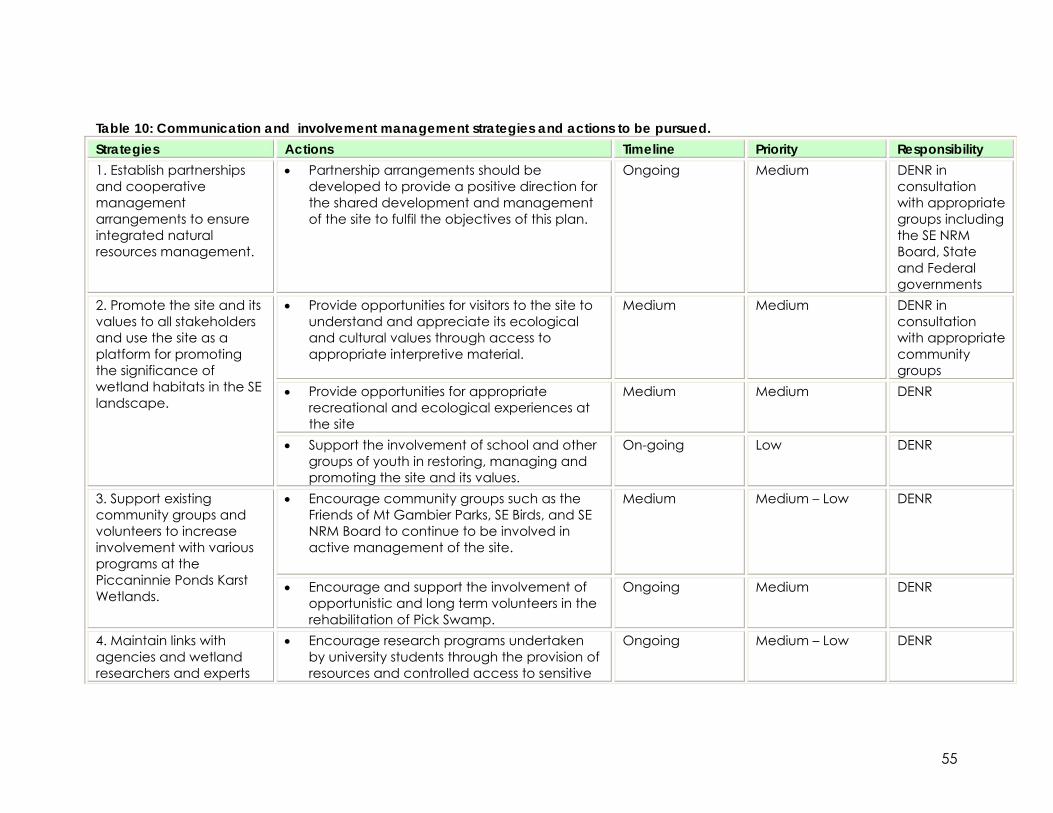
55
Table 10: Communication and involvement management strategies and actions to be pursued. Strategies Actions Timeline Priority Responsibility 1. Establish partnerships and cooperative management arrangements to ensure integrated natural resources management.
• Partnership arrangements should be developed to provide a positive direction for the shared development and management of the site to fulfil the objectives of this plan.
Ongoing Medium DENR in consultation with appropriate groups including the SE NRM Board, State and Federal governments
• Provide opportunities for visitors to the site to understand and appreciate its ecological and cultural values through access to appropriate interpretive material.
Medium Medium DENR in consultation with appropriate community groups
• Provide opportunities for appropriate recreational and ecological experiences at the site
Medium Medium DENR
2. Promote the site and its values to all stakeholders and use the site as a platform for promoting the significance of wetland habitats in the SE landscape.
• Support the involvement of school and other groups of youth in restoring, managing and promoting the site and its values.
On-going Low DENR
• Encourage community groups such as the Friends of Mt Gambier Parks, SE Birds, and SE NRM Board to continue to be involved in active management of the site.
Medium Medium – Low DENR 3. Support existing community groups and volunteers to increase involvement with various programs at the Piccaninnie Ponds Karst Wetlands.
• Encourage and support the involvement of opportunistic and long term volunteers in the rehabilitation of Pick Swamp.
Ongoing Medium DENR
4. Maintain links with agencies and wetland researchers and experts
• Encourage research programs undertaken by university students through the provision of resources and controlled access to sensitive
Ongoing Medium – Low DENR

56
Strategies Actions Timeline Priority Responsibility areas within the site. investigating aspects of
the ecological character of the site.
• Ensure research provides information relevant to the maintenance of ecological character and is consistent with the objectives of this management plan.
Ongoing Medium – Low DENR
5. Protect and enhance indigenous cultural values.
• Engage indigenous people in management decisions for Piccaninnie Ponds and Pick Swamp taking into consideration their cultural responsibilities to care for country
Short High DENR
6. Enhance the cultural value of indigenous people.
• Prepare Land Use and Occupancy maps for the region from Green Point to the Glenelg River using methods described in Tobias (2000) and incorporate findings into Ramsar Management Plan.
Medium High DENR

57
7 Monitoring and adaptive management By definition, monitoring programs are designed to inform management. In the case of Ramsar sites, monitoring programs are designed to inform management actions directed at maintaining the ecological character of the site. There are two distinct monitoring programs required for the ecological aspects of the Piccaninnie Ponds Karst Wetlands:
1. Monitoring of ecological character to inform against Limits of Acceptable Change (LAC); and
2. Monitoring of the rehabilitation of the Pick Swamp portion of the site. Both these monitoring programs are guided by the ecological management objectives and strategies as provided in the preceding section. In addition, there are specific research activities that may be required to address significant knowledge gaps identified in the ECD report. It is important to note that this management plan does not operate in isolation, but rather, seeks to integrate and build upon relevant existing monitoring (see below) and research activities. In addition, it is not the intent to provide a full monitoring program within this management plan. The development of an integrated monitoring program is an identified priority action and as such, guidance for the development of a full monitoring program is provided below.
7.1 Established monitoring
7.1.1 Hydrological monitoring Two programs are underway which will contribute to understanding the hydrology of the Piccaninnie Ponds Karst Wetlands. The first is part of a regional groundwater study being undertaken by Department for Water (DFW). The second is part of the Piccaninnie Ponds Karst Wetlands survey program aimed at establishing baseline information, particularly with regards to restorative actions at Pick Swamp. Discharge from the Outlet Creek is measured approximately quarterly by DFW. As part of the South East National Water Initiative project “Integrated Water Resource Management in the South East of South Australia,” DFW staff in Mount Gambier are currently undertaking a study focusing on spring discharge sites in the lower South East of South Australia (including Piccaninnie Ponds). The aim of this study is to gain a better understanding of the spatial and temporal variability of flows from significant groundwater discharge sites. An environmental tracer approach is being taken, analysing surface water and groundwater for isotopic and major ion concentrations. This work will improve the conceptual understanding of surface water-groundwater interactions in the region, and help build conceptual models of these processes at specific sites.
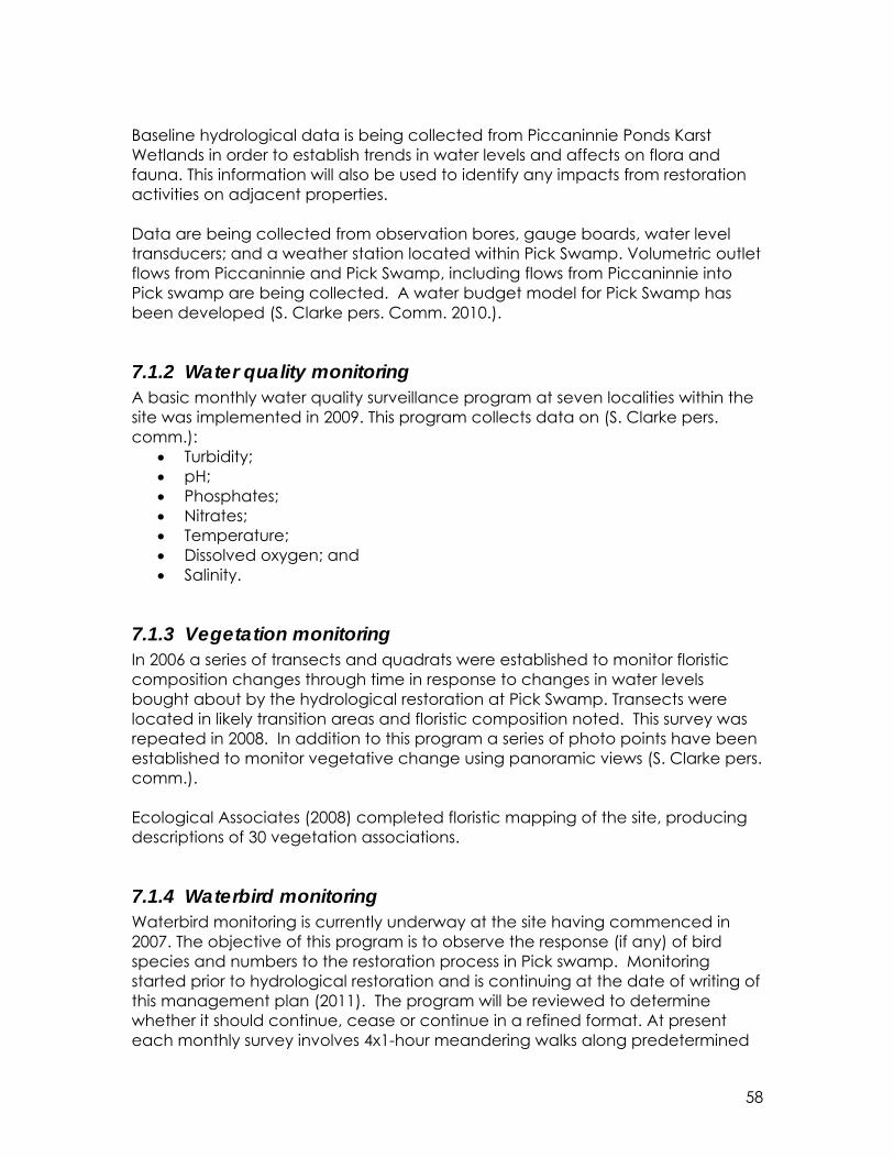
58
Baseline hydrological data is being collected from Piccaninnie Ponds Karst Wetlands in order to establish trends in water levels and affects on flora and fauna. This information will also be used to identify any impacts from restoration activities on adjacent properties. Data are being collected from observation bores, gauge boards, water level transducers; and a weather station located within Pick Swamp. Volumetric outlet flows from Piccaninnie and Pick Swamp, including flows from Piccaninnie into Pick swamp are being collected. A water budget model for Pick Swamp has been developed (S. Clarke pers. Comm. 2010.).
7.1.2 Water quality monitoring A basic monthly water quality surveillance program at seven localities within the site was implemented in 2009. This program collects data on (S. Clarke pers. comm.):
• Turbidity; • pH; • Phosphates; • Nitrates; • Temperature; • Dissolved oxygen; and • Salinity.
7.1.3 Vegetation monitoring In 2006 a series of transects and quadrats were established to monitor floristic composition changes through time in response to changes in water levels bought about by the hydrological restoration at Pick Swamp. Transects were located in likely transition areas and floristic composition noted. This survey was repeated in 2008. In addition to this program a series of photo points have been established to monitor vegetative change using panoramic views (S. Clarke pers. comm.). Ecological Associates (2008) completed floristic mapping of the site, producing descriptions of 30 vegetation associations.
7.1.4 Waterbird monitoring Waterbird monitoring is currently underway at the site having commenced in 2007. The objective of this program is to observe the response (if any) of bird species and numbers to the restoration process in Pick swamp. Monitoring started prior to hydrological restoration and is continuing at the date of writing of this management plan (2011). The program will be reviewed to determine whether it should continue, cease or continue in a refined format. At present each monthly survey involves 4x1-hour meandering walks along predetermined

59
transects; recording species presence, abundance and habitat type (S. Clarke pers. comm.).
7.1.5 Fish monitoring A series of fish surveys and inventories were carried out over 2007/2008 in Pick Swamp and the Piccaninnie Ponds fish passageway (Hammer 2008a & b). The objective was to better understand:
• The populations of fish that inhabit the system; • The population of Yarra Pygmy Perch (Nannoperca obscura) in Crescent
Pond; and • Migratory patterns of diadromous fish entering and leaving Piccaninnie
Ponds. In July 2011 a fish monitoring program commenced at 9 sites over the entire Piccaninnie wetland system. The program aims to collect information on fish species, age groups and abundance every 4 to 6 months (S. Clarke pers comm.. 2011).
7.2 Monitoring to detect changes in ecological character
7.2.1 Applying limits of acceptable change The recommended approach to monitoring of ecological character is based on that detailed in the ECD Report for the Piccaninnie Ponds Karst Wetland Ramsar site (Butcher et al. 2011). This links monitoring programs with the Limits of Acceptable Change (LAC), both for assessing condition of the site and for informing the review and refinement of LACs. The primary aim of monitoring against the LACs is to detect significant changes in parameters that may indicate a change in ecological character in time to instigate a management response (i.e. before the change in ecological character is irrevocable). The ECD recognised that LACs could not be set, nor monitored for every component and process within the system.
7.2.2 Linking monitoring to management The monitoring program for the Piccaninnie Ponds Karst Wetlands Ramsar site has been designed to assess components and processes within the site against the relevant LACs. Limits of Acceptable Change can be updated as new information becomes available to ensure they more accurately reflect the natural variability (or normal range for artificial sites) of critical components, process and benefits/services of the Ramsar wetland. The process for assessing monitoring against LACs is provided in Figure 9 and described below.

60
Figure 9: Process for assessing results of monitoring against LAC. The initial steps in the process are designed to ensure that the data indicating a potential exceedence of an LAC are accurate. Therefore, a verification of quality control and quality assurance data from both the laboratory and the field is required. If the results indicating an exceedence of the LAC are found to be inaccurate or not within acceptable quality standards, then monitoring should continue. However, if the results are a true reflection of the status of components and process within the Ramsar site, further action is required. If LAC have been exceeded, it is important to next assess the ecological significance of this exceedence. This will involve expert opinion and analysis of the data and other supporting information to determine if the monitoring results indicate a risk or increased threat to the ecological character of the system. Typical analysis may include:
• The magnitude of the exceedence (e.g. if the LAC is a pH > 7 and a pH of 7.1 is recorded, this may not be considered a significant threat to the ecological of the system);
• The spatial or temporal extent of the exceedence (e.g. if the monitoring result limited to an isolated location and a single point in time this may not be considered a significant threat to the ecological character of the

61
system);
• Potential contributing factors, or causes of the exceedence (i.e. supporting information should be analysed to determine potential causes for the monitoring results. This may include unusual weather patterns, extreme events, human activities. A decision will then need to be made as to whether this is likely to be a sustained and significant threat to ecological character or a one-off / rare event).
If expert opinion and analysis determines that the exceedence of LAC was not ecologically significant, this should trigger a review of the LAC to determine if they are appropriate. The LAC in many cases were developed based on limited knowledge. Therefore, as more information and data becomes available, they should be refined to better reflect the natural variability within the system. Finally, if the exceedence of LAC is found to be ecologically significant, then management actions must be implemented to protect and maintain the ecological character of the system. Actions may range from increased frequency or extent of monitoring to increase understanding of the impact to the system, to on ground actions to address the threatening activities contributing to the impact to ecological character. In order to implement the process described above, it is recommended that a Technical Advisory Panel be established. This panel should comprise scientific experts, on-ground managers and other stakeholders with knowledge and experience in the Ramsar Site. The panel should meet at least once a year to discuss the results of the previous years monitoring, determine if there have been changes to components and processes that represent a significant threat to the ecological character of the site and to recommend future monitoring and management actions.
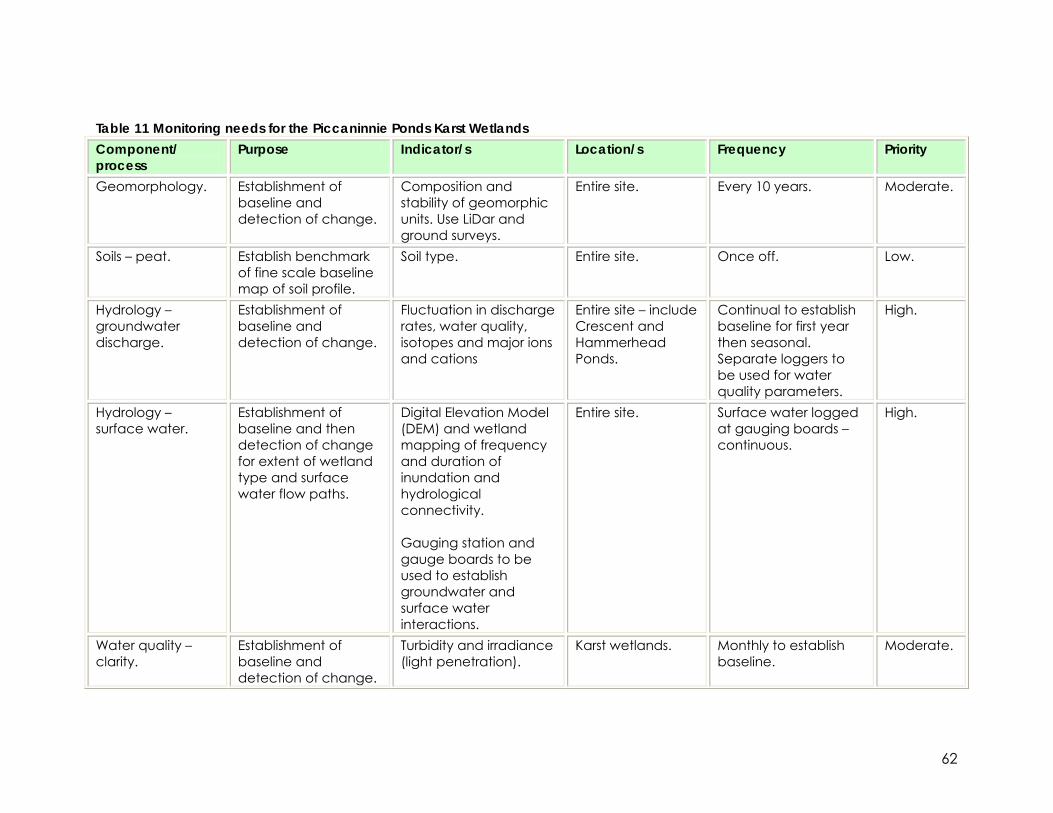
62
Table 11 Monitoring needs for the Piccaninnie Ponds Karst Wetlands Component/ process
Purpose Indicator/s Location/s Frequency Priority
Geomorphology. Establishment of baseline and detection of change.
Composition and stability of geomorphic units. Use LiDar and ground surveys.
Entire site. Every 10 years. Moderate.
Soils – peat. Establish benchmark of fine scale baseline map of soil profile.
Soil type. Entire site. Once off. Low.
Hydrology – groundwater discharge.
Establishment of baseline and detection of change.
Fluctuation in discharge rates, water quality, isotopes and major ions and cations
Entire site – include Crescent and Hammerhead Ponds.
Continual to establish baseline for first year then seasonal. Separate loggers to be used for water quality parameters.
High.
Hydrology – surface water.
Establishment of baseline and then detection of change for extent of wetland type and surface water flow paths.
Digital Elevation Model (DEM) and wetland mapping of frequency and duration of inundation and hydrological connectivity. Gauging station and gauge boards to be used to establish groundwater and surface water interactions.
Entire site. Surface water logged at gauging boards – continuous.
High.
Water quality – clarity.
Establishment of baseline and detection of change.
Turbidity and irradiance (light penetration).
Karst wetlands. Monthly to establish baseline.
Moderate.

63
Component/ process
Purpose Indicator/s Location/s Frequency Priority
Water quality - salinity and nutrients.
Establishment of baseline and detection of change.
EC and nutrients (total nitrogen, nitrate, total phosphorous). Salinity depth profiles.
Karst wetlands. Groundwater bore CAR011.
Monthly to establish baseline.
Moderate.
Vegetation – extent of broad types.
Establishment of baseline and detection of change
Extent of broad community types – remote sensing.
Entire site Every 10 years. High.
Vegetation – community composition.
Establishment of baseline and detection of change.
Community composition of vegetation types (field surveys) and extent of changes.
Entire site. Every 5 years. High.
Karst vegetation associations.
Establishment of baseline and detection of change.
Composition and percent cover of species. Need to establish temporal and seasonal variability.
Karst wetlands. Include baseline for Crescent and Hammerhead Ponds.
Monthly to establish baseline and then annually. Requires cave diving licence.
High.
Fish – general. Detection of change Community composition, particularly continued exclusion of introduced species. Maintenance of hydrological connectivity to the sea for diadromous species.
Entire site. Annual. Moderate.
Fish – abundance. Detection of change. Abundance of key species Yarra pygmy perch, dwarf galaxias.
Crescent Pond and Pick Swamp.
Annual. Moderate.
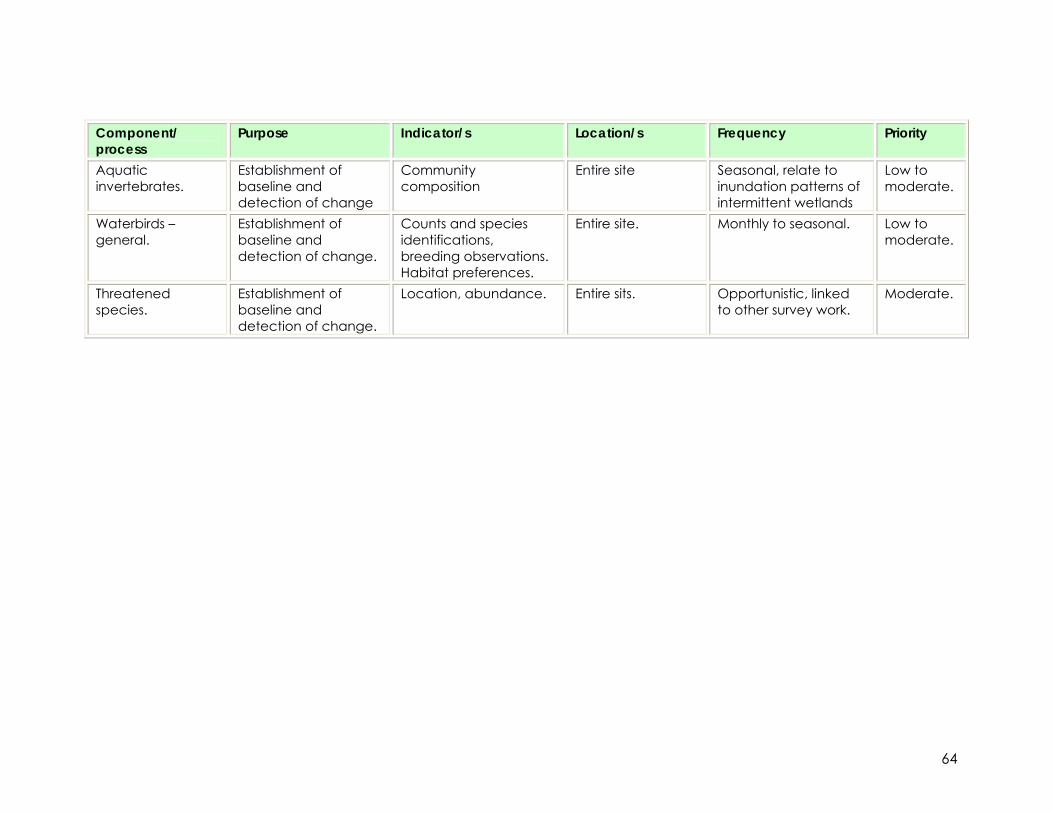
64
Component/ process
Purpose Indicator/s Location/s Frequency Priority
Aquatic invertebrates.
Establishment of baseline and detection of change
Community composition
Entire site Seasonal, relate to inundation patterns of intermittent wetlands
Low to moderate.
Waterbirds – general.
Establishment of baseline and detection of change.
Counts and species identifications, breeding observations. Habitat preferences.
Entire site. Monthly to seasonal. Low to moderate.
Threatened species.
Establishment of baseline and detection of change.
Location, abundance. Entire sits. Opportunistic, linked to other survey work.
Moderate.

65
7.2.3 Monitoring the rehabilitation of Pick Swamp The rehabilitation of Pick Swamp is guided by a rehabilitation plan (Clarke 2007), which includes aspects of evaluation and monitoring. An action under this management plan for the Ramsar site is the development of an integrated monitoring program. This should encompass the monitoring and evaluation of the rehabilitation program at Pick Swamp. Rehabilitation of aquatic systems is a relatively common activity in Australia. However, the systematic collection of information for monitoring and evaluation is rarely undertaken (Bureau of Rural Sciences 2008; Rutherfurd et al. 2000). Rehabilitation monitoring is useful for (adapted from Bureau of Rural Sciences 2008):
• Reassessing rehabilitation priorities; • Evaluating the success or failure of the activity; • Evaluating and improving the effectiveness of the rehabilitation
techniques; • Evaluating return on investment; and • Informing on rehabilitation and revegetation activities at regional and
national scales. In developing and implementing a rehabilitation monitoring program for Pick Swamp, consideration should be given to measures that inform both on the success of rehabilitation activities as well as ecological outcomes.

66
8 References Bachmann, M.R. (2002). Silky Tea-tree and Cutting Grass Wetland Rehabilitation Project 1999-2002. Nature Conservation Society of South Australia, Adelaide. Barker, W.R., Barker, R.M., Jessop, J.P. and Vonow, H.P. (eds.) (2005). Census of South Australian Vascular Plants. 5th Edition. J. Adelaide Bot. Gard. Supplement 1. (Botanic Gardens of Adelaide & State Herbarium: Adelaide). Bureau of Rural Sciences, (2008). A field manual for describing and mapping revegetation activities in Australia, Bureau of Rural Sciences, Canberra. Butcher, R., Hale J., and Cottingham, P. (2011). Draft ecological character description for the Piccaninnie Ponds Karst Wetlands. Prepared for DENR, Mt Gambier. Clarke, S (2007). The Hydrological and Vegetative Restoration Plan for Pick Swamp Department for Environment and Heritage: Mount Gambier, South Australia. Clarke S. (2008). Pick Swamp: pasture to marsh—just add water. Wetlands Australia, 16, pp. 10-11. Croft, T., House, G., Oppermann, A., Shaw Rungie, A., and Zubrinich, T. (1999). Biodiversity Plan for South East South Australia. DENR South Australia. DEP (1992). Piccaninnie Ponds Conservation Park management plan. Department of Environment and Planning, South East Region. DEW (Department of Environment and Water) (2005), Background Paper to the Wildlife Conservation Plan for Migratory Shorebirds. DEWHA (2008). National Framework and Guidance for Describing the Ecological Character of Australia’s Ramsar Wetlands. Module 2 of the National Guidelines for Ramsar Wetlands—Implementing the Ramsar Convention in Australia. Australian Government Department of the Environment, Water, Heritage and the Arts, Canberra. DSE (2005). Framework for describing the Ecological Character of Ramsar wetlands including a description of the ecological character of the Barmah Forest Ramsar Site. Victorian Government Department of Sustainability and Environment. Duncan, M., Pritchard, A. and Coates, F. (2007). National Recovery Plan for Fifteen Threatened Orchids in Victoria and South Australia. Department of Sustainability and Environment, Melbourne. Draft.

67
Ecological Associates (2008) Floristic Mapping of the Piccaninnie Ponds Conservation Park and Pick Swamp. Draft report to DENR. Environment Australia (2001). A Directory of Important Wetlands in Australia, Third Edition. Environment Australia, Canberra Halbert, C.L. (1993). How adaptive is adaptive management? Implementing adaptive management in Washington state and British Columbia. Reviews in Fisheries Science 1:261–283 Hale, J., and Butcher, R. (2008). Ecological Character Description of the Peel-Yalgorup Ramsar site. A report to the Department of Environment and Conservation and Peel Harvey Catchment Council. Hammer, M. (2008a). Pilot fish movement study in Lower South East, South Australia. Draft Report to Department for Environment and Heritage, South Australian Government. Aquasave Consultants, Adelaide. Hammer, M. (2008b). Report of spring 2007 fish monitoring at the western Piccaninnie wetland complex, lower south east South Australia. Report to DENR, Mt Gambier. Aquasave Consultants, Adelaide. Hammer, M., Wedderburn, S., and van Weenan, J. (2007). Draft Action Plan for South Australian Freshwater Fishes (www.environmentsa.sa.gov.au). Native Fish Australia (SA), Adelaide. Mitsch, W.J., and Gosselink J.G. (2000). Wetlands Third Edition, John Wiley & Sons, Inc New York. Morghan, K.J.R., Sheley, R.L. and Svejcar, T.J. (2006). Successful adaptive management—The integration of research and management. Rangeland Ecol. Manage. 59:216–219. Ramsar Convention (2005). Resolution IX.1 Annex A. A Conceptual Framework for the wise use of wetlands and the maintenance of their ecological character. Rydin, H., Jeglum, J.K., and Hooijer, A. (2006). The Biology of Peatlands. Oxford University Press. Sands, D.P.A. and New, T.R. (2002). The Action Plan for Australian Butterflies, Environment Australia, Canberra. Sands, D.P.A. and New, T.R. (2002). The Action Plan for Australian Butterflies, Environment Australia, Canberra. Schreiber, S.G., Bearlin, A.R., Nicol, S.J., and Todd, C.R. (2004). Adaptive management: a synthesis of current understanding and effective application. Ecological Management and Restoration 5: 177-182. SECWMB (2001). Water allocation plan for the Comaum-Caroline prescribed wells area. South East Catchment Water Management Board.

68
Tobias, T. (2000). Chief Kerry’s Moose: A guidebook to land use and occupancy mapping, research design and data collection. Ecotrust Canada and the Union of BC Indian Chiefs.

69
Appendix A: Ramsar Convention matters The Convention on Wetlands of International Importance is an intergovernmental treaty, which provides the framework for national action and international cooperation for the conservation and wise use of wetlands and their resources. The Convention was signed in Ramsar, Iran in 1971 and is commonly referred to as the “Ramsar Convention”. As a signatory, Australia has obligations with respect to designating and managing designated wetlands. Ramsar nomination The Piccaninnie Ponds Karst Wetlands is nominated for listing as a Wetland of International Importance under the Ramsar Convention on Wetlands. Nomination of a site for Ramsar listing requires at a minimum::
• Ramsar Information Sheet including justification against at least one criterion for identifying wetlands of international importance;
• Stakeholder support and management agreement for listing; • A description of the ecological character and values of the wetland; • A plan of management to protect values and maintain the ecological
character of the wetland. The requirements for listing, managing, monitoring, evaluating and reporting on Ramsar wetlands are outlined in Table 1. Table 1: Requirements for listing, managing, monitoring, evaluating and reporting on Ramsar wetlands (based on DEWHA 2008, DSE 2005) Activity Output Ramsar site listing • Criteria for identifying wetlands of international
importance met by the wetland • Stakeholder support and management agreement for
listing • Ramsar information sheet • Description of ecological character • Management plan
Plan of Management • Consultation requirements and plan • General wetland description • Ecosystem services (including Ramsar criteria) and risks • Wetland risk assessment • Management objectives and strategies • Implementation program • Review ecological character • ≤ 6 yearly review of RIS • Monitoring program
Implementation of Plan of Management
• Annual works program
Environmental Impact Assessment
• Referral and assessment of actions under the EPBC Act • Conditions for approved actions
Monitoring • Results and conclusions • Status of ecological character

70
Evaluation • Status of ecological character • Recommendations for review of management plan • Effectiveness of conditions to minimise environmental
impact of actions Reporting • Updates to the Ramsar Information Sheet
• National reports to each Conference of Contracting Parties
• Notification to Ramsar Secretariat by Contracting Parties of change in ecological character, if required
Communication, Education and Public Awareness activities
• Communication • Education • Public awareness raising
The requirements for nomination of the Piccaninnie Ponds Karst Wetlands have been described in three key documents:
1. Ecological Character Description (ECD) (Butcher et al. 2011) - provides the baseline description of ecological character of the Piccaninnie Ponds Karst Wetlands;
2. Ramsar Information Sheet (RIS) - summarises the key information (site details, criteria for which a site is listed, key components, processes and services) regarding the character of Ramsar site; and
3. Ramsar Management Plan – provides site-based planning and management integrated into the wider planning system at local, regional or national levels.
This document, the Ramsar Management Plan (RMP), is the third of the key documents required to support Ramsar nomination, and should be read in conjunction with the ECD report (Butcher et al. 2011). Ramsar criteria The Ramsar criteria against which Piccaninnie Ponds Karst Wetlands are nominated (Butcher et al. 2011) are identified in Table 2. Justification of the Ramsar criteria met is contained in section 2.3.1. Table 2: Criteria for identifying Wetlands of International Importance (from Butcher et al. 2011). Those criteria met by the Piccaninnie Ponds Karst Wetlands are highlighted in green. Number Basis Description Group A. Sites containing representative, rare or unique wetland types Criterion 1 A wetland should be considered internationally important if it
contains a representative, rare, or unique example of a natural or near-natural wetland type found within the appropriate biogeographic region.
Group B. Sites of international importance for conserving biological diversity Criterion 2 Species and
ecological communities
A wetland should be considered internationally important if it supports vulnerable, endangered, or critically endangered species or threatened ecological communities.
71
Criterion 3 Species and ecological communities
A wetland should be considered internationally important if it supports populations of plant and/or animal species important for maintaining the biological diversity of a particular biogeographic region.
Criterion 4 Species and ecological communities
A wetland should be considered internationally important if it supports plant and/or animal species at a critical stage in their life cycles, or provides refuge during adverse conditions.
Criterion 5 Waterbirds A wetland should be considered internationally important if it regularly supports 20,000 or more waterbirds.
Criterion 6 Waterbirds A wetland should be considered internationally important if it regularly supports 1% of the individuals in a population of one species or subspecies of waterbird.
Criterion 7 Fish A wetland should be considered internationally important if it supports a significant proportion of indigenous fish subspecies, species or families, life-history stages, species interactions and/or populations that are representative of wetland benefits and/or values and thereby contributes to global biological diversity.
Criterion 8 Fish A wetland should be considered internationally important if it is an important source of food for fishes, spawning ground, nursery and/or migration path on which fish stocks, either within the wetland or elsewhere, depend.
Criterion 9 Other taxa A wetland should be considered internationally important if it regularly supports 1% of the individuals in a population of one species or subspecies of wetland-dependent non-avian animal species.
Ecological character The act of designating a wetland as a Ramsar site carries with it certain obligations, including managing the site to retain its ‘ecological character’ and to have procedures in place to detect if any threatening processes are likely to, or have altered the ‘ecological character’. Thus, understanding and describing the ‘ecological character’ of a Ramsar site is a fundamental management tool for signatories and local site managers which should form the baseline or benchmark for management planning and action, including site monitoring to detect negative impacts. The Ramsar Convention defines ecological character and change in ecological character as follows: Ecological character = the sum of the biological, physical and chemical components of the wetland ecosystem, and their interactions, which maintain the wetland and its products, functions and attributes. Change in ecological character = the impairment or imbalance in any biological, physical or chemical components of the wetland ecosystem, or in their interactions, which maintain the wetland and its products, functions and attributes.

72
Ecological character is the combination of the ecosystem components, processes, benefits and services that characterise the wetland at a given point in time1 (Ramsar Convention 2005, Resolution IX.1 Annex A). Change in ecological character is defined as the human-induced adverse alteration of any ecosystem component, process and/or ecosystem benefit or service (Ramsar Convention 2005, Resolution IX.1 Annex A). Wise use The concept of “wise use” is an underling principle of the Ramsar Convention and Article 3.1 of the Convention states that the Contracting Parties "shall formulate and implement their planning so as to promote the conservation of the wetlands included in the List, and as far as possible the wise use of wetlands in their territory". Wise use of wetlands is defined as: ‘the maintenance of their ecological character, achieved through the implementation of ecosystem approaches, within the context of sustainable development’ (Ramsar Convention 2005, Resolution IX.1 Annex A). The wise use provisions apply to all wetlands and their support systems within the territory of a Contracting Party, both those wetlands designated for the List, and all other wetlands. The concept of wise use seeks both the formulation and implementation of general wetland policies, and wise use of specific wetlands. These activities are integral parts of sustainable development. EPBC Act The EPBC Act regulates actions that will have or are likely to have a significant impact on any matter of national environmental significance, which includes the ecological character of a Ramsar wetland (EPBC Act 1999 s16(1)). An action that will have or is likely to have a significant adverse impact on a Ramsar wetland will require an environmental assessment and approval under the EPBC Act. An ‘action’ includes a project, a development, an undertaking or an activity or series of activities (http://www.environment.gov.au/epbc/index.html). Australian Ramsar Management Principles The EPBC Act establishes a framework for managing Ramsar wetlands, through the Australian Ramsar Management Principles (EPBC Act 1999 s335), which are set out in Schedule 6 of the Environment Protection and Biodiversity Conservation Regulations 2000. These principles are intended to promote national standards of management, planning, environmental impact assessment, community involvement, and monitoring, for all of Australia’s Ramsar wetlands in a way that is consistent with Australia’s obligations under the Ramsar Convention. 1 The phrase ‘at a given point in time’ refers to Resolution VI.1 paragraph 2.1, which states that ‘It is essential that the ecological character of a site be described by the Contracting Party concerned at the time of designation for the Ramsar List, by completion of the Information Sheet on Ramsar Wetlands’ (as adopted by Recommendation IV. 7).

73
A checklist provided by DEWHA (http://www.environment.gov.au/water/environmental/wetlands/ramsar/management.htm accessed September 22, 2008) provides an overview of obligations with respect to management planning under the Australian Ramsar Management Principles (Text Box 1).
Text Box 1: Australian Ramsar management principles checklist, SEWPAC. Purpose of a Ramsar Management Plan
1. Does the management plan describe the ecological character of the wetland?
2. Does the management plan clearly demonstrate that actions will be taken to maintain the ecological character of the wetlands?
3. Does the plan promote and describe actions to conserve the wetland? 4. Does the plan promote and describe actions for the wise and sustainable
use of the wetland for the benefit of all people in a way that is compatible with and does not impact on the natural properties of the ecosystem?
5. Does the plan include public consultation where decisions and actions may have an impact on the wetland and where the public may have an interest?
6. Does the plan include the involvement of people who have a particular interest in the wetland and those who may be affected by the management of the wetland?
7. Does the plan include processes that provide for continuing community and technical input?
8. Does the management plan include a description of the characteristics that make the wetland of international importance under the Ramsar Convention?
9. Does the plan describe actions that will be taken to deal with the impacts that endanger the wetland's ecological character?
10. If the wetland requires restoration or rehabilitation, what actions have been identified to undertake this work?
11. Does the plan adequately consider monitoring and reporting on the state of the wetland's ecological character on a continuing basis?
12. Is the management plan based on an integrated catchment management approach?
13. Does the plan allow for a review process within a seven-year period? 14. Do all anticipated actions, which are likely to have a significant impact on
the ecological character of the wetland, include assessment under a statutory environmental impact assessment and approval process?

74
Some of the important functions of a RMP (Ramsar Convention 20022) are to:
• Identify the objectives of site management; • Identify the factors that affect, or may affect, the ecological character of
the site; • To identify the management required to achieve the objectives; • To maintain continuity of effective management and ensure compliance
with local, national, and international policies; • To define the monitoring requirements; • To enable communication within and between organisations and
stakeholders. This RMP provides:
• A guiding vision for managing the Piccaninnie Ponds Karst Wetlands; • A summary of the ecological character of the wetland; • A summary of the values associated with the wetland to be protected or
enhanced; • A summary of key threats to be addressed; • Key management objectives to protect or enhance the values of the
wetland; • The environmental protection and rehabilitation measures required to
meet objectives; • The management arrangements needed to protect and manage
cultural, recreation and tourism values; and • Factors that should be considered when developing a monitoring
program from which to evaluate the condition of the wetland and effectiveness of management arrangements.
The Ramsar Managing Wetlands Handbook3 (2010) Handbook provides a framework for designing and implementing a wetland monitoring program (Figure 7). Although this framework is not a prescriptive methodology, it provides guidance on what should be considered in program design. This framework should be used to guide the development of a detailed monitoring plan for the Piccaninnie Ponds Karst Wetlands.
2 Ramsar Convention (2002). New Guidelines for management planning for Ramsar sites and other wetlands. Ramsar Convention Resolution VIII.14. http://www.ramsar.org/key_guide_mgt_new_e.htm 3 Ramsar Managing Wetlands Handbook (2010) http://www.ramsar.org/pdf/lib/hbk4-18.pdf

75
Figure 7: Framework for designing a wetland monitoring programme (from Ramsar Managing Wetlands Handbook (2010))
76
Appendix B: Adaptive management framework Adaptive management is about learning and applying what has been learnt to improve the management of operational or investment programs and is often referred to as “learning by doing” (Schreiber et al. 2004). The key aspect of adaptive management in the context of this management plan is the direct feedback loop between researchers / technical specialists and managers, so management decisions can be improved as research and monitoring provide information about the system (Halbert 1993). The key output of this strong link between monitoring and management is that management can proceed despite uncertainty about outcomes. Adaptive management does not need to wait until managers have researched all management options, but instead is developed using the best information available. As management proceeds, actions and techniques that do not work are discarded and replaced by others. Thus, management is based on an experimental comparison between alternative management strategies and increases in the understanding of the system (Morghan et al. 2006). The development of an adaptive management framework is essential to ensure that management actions are not changed and implemented in an ad hoc manner. A deliberate and conscious process is required to structure the monitoring, evaluation and review aspects of adaptive management. It is important to recognise that adaptive management is an amalgamation of scientific methods, policy and socio-economic analysis and involves the participation and cooperation of a wide range of stakeholders. The adaptive management framework for the management of the Piccaninnie Ponds Karst Wetlands (Figure 8) illustrates how the outputs of monitoring and research are directly used to inform management actions as well as for the review and revision of management targets (including Limits of Acceptable Change for the Ramsar site).

77
Figure 8: Adaptive management framework for the Piccaninnie Ponds Karst Wetlands management plan. The vision (section 1.3) and overarching management objectives (section 1.4) form the basis of the adaptive management framework. The vision is designed to reflect the perspectives of the range of stakeholders interested in the management and condition of the site. It includes consideration of ecological, social and economic aspects of the Piccaninnie Ponds Karst Wetlands and the obligations for management of a wetland of international importance under the Ramsar Convention. The Ecological Character Description (ECD) largely informs the next two steps in the framework. The ECD identifies the critical components, processes, benefits and services of the Ramsar site and provides some conceptual understanding of how theses components interact. This allows predictions to be made with regard to responses to threats and potential management actions. The Management Plan details the remaining steps in the framework:
• Setting management strategies (section 5); • Developing management actions (section 5); and • Describing monitoring program development (section 6).

78
Crucial to the adaptive management framework is the formal evaluation and review that flows from monitoring and research outputs. These are used not only to assess the achievement of management targets and changes in ecological condition (including informing against LAC) but also to re-assess the understanding of the system and inform the revision and / or development of new management actions.

79
Appendix C: Plant species recorded from Piccaninnie Ponds Karst Wetlands Data provided by DENR August 2008. NC = name no longer current Acacia leiophylla Acacia longifolia var sophorae Acacia melanoxylon 'Acacia myrtifolia var. myrtifolia (NC)' Acacia pycnantha Acacia verticillata ssp. ovoidea 'Acaena echinata var. (NC)' Acaena novae-zelandiae Acrotriche affinis Acrotriche serrulata Actites megalocarpa Agrostis avenacea var. avenacea Ajuga australis form Alyxia buxifolia Allocasuarina verticillata Angianthus preissianus Apalochlamys spectabilis Apium prostratum var. filiforme Apium prostratum var. prostratum Apodasmia brownii Arthropodium strictum Asperula conferta Astroloma humifusum Atriplex cinerea Austrodanthonia caespitosa Austrodanthonia geniculata Austrodanthonia racemosa var. racemosa Austrofestuca littoralis Austrostipa flavescens Azolla filiculoides Baumea arthrophylla Baumea articulata Baumea juncea Baumea laxa Billardiera cymosa (NC)' Bolboschoenus caldwellii
Bossiaea prostrata Brachyscome graminea Bromus sp. Brunonia australis Burchardia umbellata Bursaria spinosa ssp. spinosa Carex appressa Carex bichenoviana Carex fascicularis Carex gunniana Caladenia carnea Caladenia latifolia 'Carpobrotus rossii (NC)' Cassytha glabella forma dispar Cassytha pubescens Centella cordifolia Centrolepis polygyna Centrolepis strigosa ssp. strigosa Chamaescilla corymbosa var. corymbosa Chrysocephalum apiculatum Cladium procerum Clematis microphylla var. microphylla Comesperma volubile 'Convolvulus erubescens (NC)' 'Correa reflexa var. reflexa (NC)' Corybas sp. aff. Diemenica Cotula australis Cotula vulgaris var. australasica Crassula decumbens var. decumbens Crassula helmsii 'Crassula sieberiana ssp. tetramera (NC)' Cynoglossum australe Cynoglossum suaveolens Cyperus laevigatus Cyrtostylis reniformis 'Danthonia pilosa var. pilosa (NC)' Daucus glochidiatus Deyeuxia densa Deyeuxia quadriseta

80
Dianella brevicaulis Dichelachne crinita Dichondra repens Distichlis distichophylla Diuris orientis Diuris palustris Drosera auriculata Drosera peltata Drosera pygmaea Drosera whittakeri ssp. aberrans Eleocharis acuta Eleocharis pusilla 'Elymus scaber var. scaber (NC)' Epilobium billardierianum ssp. billardierianum Epilobium billardierianum ssp. cinereum Eucalyptus obliqua 'Eucalyptus ovata (NC)' Eucalyptus viminalis ssp. cygnetensis Eutaxia microphylla Exocarpos cupressiformis Gahnia clarkei Gahnia trifida Galium gaudichaudii Gentianella gunniana Geranium potentilloides var. potentilloides Geranium retrorsum Glycine latrobeana Gnaphalium indutum Gonocarpus tetragynus Haloragis brownii Hakea nodosa Hemarthria uncinata var. uncinata 'Hibbertia sericea var. scabrifolia (NC)' Hydrocotyle callicarpa Hydrocotyle capillaris Hydrocotyle hirta Hydrocotyle laxiflora Hydrocotyle muscosa Hydrocotyle plebeya Hypericum gramineum Hypoxis vaginata var. vaginata Imperata cylindrica Isolepis cernua
Isolepis fluitans Isolepis nodosa Juncus bufonius Juncus caespiticius Juncus kraussii Juncus planifolius Juncus prismatocarpus Kennedia prostrata Lachnagrostis aemula Lachnagrostis billardierei ssp. billardierei Lagenophora stipitata Lemna disperma Lemna trisulca Lepidosperma gladiatum Lepidosperma laterale Lepilaena cylindrocarpa Leptinella reptans Leptocarpus brownii Leptoceras menziesii Leptospermum continentale Leptospermum lanigerum Leucophyta brownii Leucopogon lanceolatus var. lanceolatus Leucopogon parviflorus Lilaeopsis polyantha Limosella australis Linum marginale Lobelia anceps Lobelia gibbosa Logania ovata Lomandra longifolia Lomandra micrantha ssp. micrantha Lotus australis Luzula flaccida Lythrum hyssopifolia Melaleuca gibbosa 'Melaleuca lanceolata ssp. lanceolata (NC)' Melaleuca squarrosa Mentha diemenica Microlaena stipoides var. stipoides Microseris lanceolata Microtis arenaria Microtis rara

81
Microtis sp. Moss sp. Muehlenbeckia adpressa Muehlenbeckia gunnii Myoporum insulare Myosotis australis Myriophyllum salsugineum Myriophyllum simulans Myriophyllum variifolium Notodanthonia semiannularis Nymphoides gemmata Olearia axillaris Olearia ramulosa Ophioglossum lusitanicum 'Oxalis perennans (NC)' Ozothamnus ferrugineus Ozothamnus turbinatus 'Parietaria debilis (NC)' Pelargonium australe Phragmites australis Pimelea glauca Pimelea humilis Pimelea serpyllifolia ssp. serpyllifolia Plantago varia Poa fax Poa labillardieri var. labillardieri Poa poiformis var. poiformis Poa tenera Poranthera microphylla Potamogeton pectinatus 'Prasophyllum frenchii (NC)' Pratia irrigua Pratia pedunculata Pteridium esculentum Pterostylis nutans Pterostylis tenuissima Pultenaea hispidula Pultenaea stricta Pultenaea tenuifolia Ranunculus amphitrichus Ranunculus inundatus Ranunculus sessiliflorus Rhagodia candolleana ssp. candolleana
Rubus parvifolius Rumex brownii Ruppia polycarpa Ruppia sp. Samolus repens Scaevola albida Scaevola calendulacea Schoenoplectus pungens Schoenoplectus validus Schoenus apogon Schoenus breviculmis Schoenus nitens Sebaea albidiflora Sebaea ovata Selaginella gracillima Selliera radicans Senecio biserratus 'Senecio glomeratus (NC)' 'Senecio odoratus var. odoratus (NC)' Senecio picridioides Senecio pinnatifolius Senecio sp. Silybum marianum Solanum laciniatum Sonchus hydrophilus 'Spinifex sericeus (NC)' Sporobolus virginicus Spyridium phylicoides Spyridium vexilliferum var. vexilliferum Stackhousia monogyna Stackhousia spathulata Stylidium graminifolium Swainsona lessertiifolia Tetragonia implexicoma 'Thelymitra pauciflora (NC)' Themeda triandra Thysanotus juncifolius Triglochin allcoxii 'Triglochin centrocarpum (NC)' Triglochin mucronatum Triglochin procerum Triglochin sp. Triglochin striatum

82
Typha domingensis Urtica incisa Veronica sp. Narrow-linear leaves (B.G.Briggs 2531) Villarsia reniformis 'Viola hederacea (NC)' Vittadinia dissecta var. hirta Wolffia sp 'Wurmbea dioica ssp. dioica (NC)'
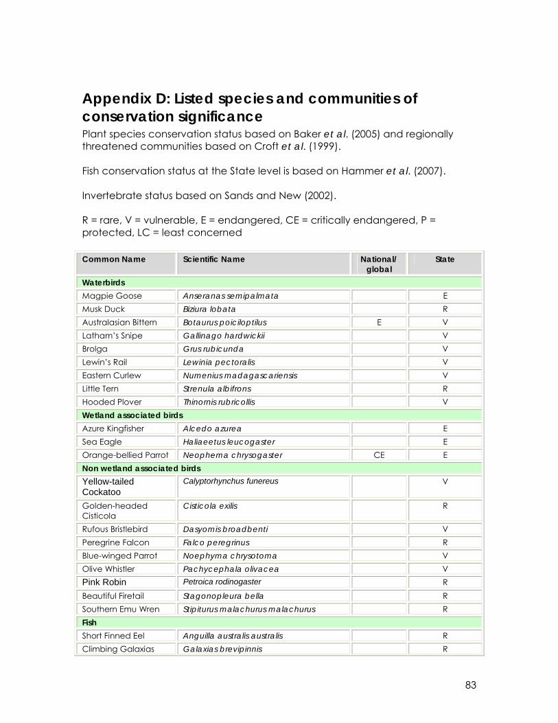
83
Appendix D: Listed species and communities of conservation significance Plant species conservation status based on Baker et al. (2005) and regionally threatened communities based on Croft et al. (1999). Fish conservation status at the State level is based on Hammer et al. (2007). Invertebrate status based on Sands and New (2002). R = rare, V = vulnerable, E = endangered, CE = critically endangered, P = protected, LC = least concerned Common Name Scientific Name National/
global State
Waterbirds Magpie Goose Anseranas semipalmata E Musk Duck Biziura lobata R Australasian Bittern Botaurus poiciloptilus E V Latham’s Snipe Gallinago hardwickii V Brolga Grus rubicunda V Lewin’s Rail Lewinia pectoralis V Eastern Curlew Numenius madagascariensis V Little Tern Strenula albifrons R Hooded Plover Thinornis rubricollis V Wetland associated birds Azure Kingfisher Alcedo azurea E Sea Eagle Haliaeetus leucogaster E Orange-bellied Parrot Neophema chrysogaster CE E Non wetland associated birds Yellow-tailed Cockatoo
Calyptorhynchus funereus V
Golden-headed Cisticola
Cisticola exilis
R
Rufous Bristlebird Dasyomis broadbenti V Peregrine Falcon Falco peregrinus R Blue-winged Parrot Noephyma chrysotoma V Olive Whistler Pachycephala olivacea V Pink Robin Petroica rodinogaster R Beautiful Firetail Stagonopleura bella R Southern Emu Wren Stipiturus malachurus malachurus R Fish Short Finned Eel Anguilla australis australis R Climbing Galaxias Galaxias brevipinnis R

84
Common Name Scientific Name National/ global
State
Dwarf Galaxias Galaxiella pusilla V V Spotted Galaxias Galaxias truttaceous E Pouched Lamprey Geotria australis V Southern Pygmy Perch
Nannoperca australis E, P
Yarra Pygmy Perch Nannoperca obscura V E, P Variegated Pygmy Perch
Nannoperca variegata E, P
Congolli Pseudaphritis urvillii R Mammals Swamp Antechinus Antechinus minimus E Reptiles Swamp skink Egernia coventryi E Invertebrates – Lepidoptera Sedge-skipper Hesperilla chrysotricha LC Flame Sedge-skippers Hesperilla idothea V Bright-eyed Brown Heteronympha cordace wilsoni CE CE Striped Xenica Oreixenica kershawi kanunda V Silver Xenica Oreixenica lathoniella V Splendid Ochre Trapezites symmomus LC Invertebrates - Parastacidae Glenelg Spiny Cray Euastacus bispisnosus E Plants Baumea laxa R Grass Daisy Brachyscome graminea R Leafy Twig Rush Cladium procerum R Carex gunniana R Heath Bent Grass Deyeuxia densa R Sun Dew Drosera whittakeri ssp. aberrans R Tall Sawsedge Gahnia clarkei R Mountain Gentain Gentianella gunniana V Glycine latrobeana V Haloragis brownii R Branching Rush Juncus prismatocarpus V Creeping Cotula Leptinella reptans (syn. Cotula reptans) R Luzula flaccida V Bottlebrush Teatree Melaleuca squarrosa R Slender Mint Mentha diemenica R Scented Onion Orchid
Microtis rara R
Varied Milfoil Myriophyllum variifolium R Entire Marshwort Nymphoides gemmata V Scaly Poa Poa fax R

85
Common Name Scientific Name National/ global
State
Maroon Leek-orchid Prasophyllum frenchii E E Swamp Greenhood Pterostylis tenuissima V V River Buttercup Ranunculus inundatus R Scented Fan Flower Scaevola calendulacea V Swamp Gum Eucalyptus ovata Woodland E Silky Teatree Leptospermum lanigerum Tall Closed
Shrubland (Wet Shrubland) E

86
Appendix E: Consultation on the Ramsar listing of the Piccaninnie Ponds Karst Wetlands. Stakeholder engagement and consultation for the Piccaninnie Ponds Karst Wetlands nomination was undertaken by Waters Edge Consulting to engage individuals and groups, including landholders adjoining the site, individuals recognised as Boandik, local naturalist groups, cave diving groups, SA Tourism Commission, Birds Southeast, that could be impacted by the wetlands becoming a Ramsar listed site. Waters Edge framed the consultation process in two parts: Aboriginal Groups consultation and General Stakeholders. 1. Aboriginal consultation - July 2008 The Boandik (also know as Bunganditj) people of south-east Australia are the Traditional Owners of Piccaninnie Ponds Karst Wetlands. Consultation was hindered by accessing the small number of Boandik people who are still actively using country and the fact that the Boandik people are not as well resourced in terms of NRM engagement as other groups such as the Ngarrindjeri people. Dr Muller met with the SE Indigenous Focus Group and with people recognised as Boandik: Aunty Valda Brennan, Uncle Malcolm Anderson and Ken Jones. Auntie Valda and Uncle Malcolm met with Kerri in Mt Gambier and Ken Jones took Kerri on a tour of the region showing the issues in the catchment as well as on-site works and impacts. The following comments were made during that consultation period. Boandik comments • The area from Browns Bay to the Glenelg River should be managed as one
hydrological unit without worrying about State borders • Sheet flow is very important to the wetland system. Any disruption to that
disrupts the whole wetland system. • Fences need to be removed where ever possible to open up the country
again • In areas that are grazed by sheep and cattle there are 4 native plant species
compared with 60 in areas that are only grazed by native fauna • Important corridor for Orange-bellied Parrot and blue wings (parrots?) along
the coast that is being converted to houses – also important from them to have open grasslands near by – bird counts are conducted in the open grassy areas
• The drains are cleared out every year which digs them down deeper into the peat and the groundwater which increases the rates of drainage. The surface flooding has gone.
• We are in trouble if they are having to irrigate peat soils – the groundwater is dropping away rather than filling the wetlands
• The pivots are the biggest problem – taking away the water from the wetlands – so are the trees, the gums and the pines, taking away the water from the wetlands

87
• Important to let the drains back up and flood out over country and wet the wetlands
• Important Emu Wren habitat in the scrub near Browns Bay • Need to purchase land between AS DEH owned parcel and the Glenelg
River so that the sheet flow can be re-established and the OBP corridor can be preserved
• Mark Bachmann and Steve Clarke have maps of what the country looked like when white man came
• Black people have been silenced by losing the land and their lives – we had the best country so we were almost wiped out very quickly
• We use the wetlands for eels, fish, bush tucker – there are middens and stone huts here that show permanent settlement – this place was very important tucker and very good place to live, so abundant for the old people
• Coorong wattle has been moving in since the 1930s after the really bad rabbit plagues
• Areas that are watered with centre pivots take a long time to recover • Crescent sinkhole in Pick Swamp is really important – just like Piccaninnie
Ponds but much harder to get to and so is in better condition – we don’t go there much just occasionally – brolgas are breeding in there – one pair that comes back each year – getting smarter about where to build nests each year
• Important that sheet flows from upwellings are allowed to flow across the country without being blocked up or drained to sea – we will kill this country if don’t get the water balance right – they are draining off the water and leaving behind the salt
• The sea is coming back up the drain in to Piccaninnie Ponds – the salt will kill it • The upper freshwater lens has been pumped dry and now people are getting
into saltier water underneath – like the Woolwash Caravan Park -= they ran out of fresh water
• Purchase more land to include the puddings – water should sit on country from the coastal dunes back to the puddings – they are important sites for men’s initiations – buy back Greenpoint wetland or co-manage for wetland ecoservices – don’t build an embankment to save a few lambs when the wetlands are worth so much more
• Reconnect the waterways from Browns Bay to the Glenelg River • We need a regional plan for our assets all the way across from Victoria to the
Coorong • There are important eel smoking trees here that were used to smoke eels for
trading with other indigenous people who had things Boandik wanted • Connection between the wetlands and the stringy bark woodlands is really
important • Cultural economy is linked to wetland health • All species of ducks are here • 3 pairs of bitterns • Unimin might be interested in co-management or a land trade for the
puddings • Corporate responsibility is also an important thing to foster – so much of our
important country is privately owned

88
• Along the coastline Boandik people lived anywhere there was freshwater • Look after the groundwater and everything else will be ok • The Blue Lakes are dropping that is a sign that too much water is being taken
out or drained to sea • The whole area being drained from Penola to the coast is the biggest threat
to the wetlands in the whole region – other Ramsar sites too like Bool Lagoon are at threat from that
• We have to save water, bring it back inland and not drain it to sea • 8 Mile, Blackfords Drain all of them, turn them inland • Put stones in the drains to block them up and change the gradient back to
the wetlands not to sea • Dam the drains and make wetlands again • There were very few places that freshwater ran to sea before white man
started draining • We need to get out onto country with DEH staff, we need to walk around with
Peter Alexander and show how it is supposed to work and how we need to change the drains
2. General Stakeholder Consultation - May 2008 Peter Cottingham and Dr. Kerri Muller (WEC) met with key stakeholder representatives early in the process to explain the project and its purpose. Their aim was twofold: 1. to gather information about stakeholder views on the ecological values of the
Piccaninnie Ponds Karst Wetlands and the threats to those values, to feed into the production of the nomination documents, and
2. Inform the community and groups with an interest in the site of the nomination process, to ensure they have an open forum to communicate their concerns and/or support for the process.
This was completed through on-on-one communication with some individuals but the primary forums for communication were two workshop sessions held in Mount Gambier in May 2008. General Stakeholder groups represented in consultation process: Lower South East NRM Group South East Consultative Committee Department of Environment and Heritage (now DENR) Friends of Shorebirds Port MacDonnell Landcare Group Birds South East South East Consultative Committee Lower South East NRM Group Friends of Mt Gambier Parks Department of Water Land and Biodiversity Conservation (now DfW) Cave Divers Association of Australia SE NRM Board Department of Primary Industries and Resources of South Australia Glenelg Hopkins Catchment Management Authority (Vic)

89
AB Ocean Divers (Victoria) Mount Gambier City Council SA Tourism Commission (Limestone Coast Tourism) Forestry SA General Stakeholder Comments SWOT analysis was used at the facilitated workshops to discuss the Strengths Weaknesses, Opportunities and Threats to the nomination and main points are outlined below: Strengths Strengths were considered to include:
• Available information to support Ramsar criteria 1 – 3 (criterion 1 in particular);
• Helps meet Australia’s obligation to have the full range of representative wetland types listed;
• Certainty of local management (wetland totally within the park boundary, water levels and hydrology via management of the outlet sill, management responsibility resting with DEH with ongoing cooperation with other government agencies);
• The system is dynamic and response to rehabilitation measures can be demonstrated;
• Strong support from local stakeholder groups; • The site is increasing in popularity as an education resource; • The site is located close to local population centers and condition is visible
to visitors. A question raised at the workshop was the “What was the reasoning for the Ramsar nomination?” The wetland is considered to be of national and international importance, and should be managed as such. Ramsar listing will add impetus to the consolidation of management and wetland rehabilitation responsibility, increased protection under the EPBC Act and the potential for seeking increased resources to protect or improve the site. Weaknesses Weaknesses were considered to include:
• The perception that Ramsar listing will result in exclusion or restriction of use (e.g. of recreation at the site, or in terms of management of nearby private land).
Opportunities: Opportunities identified included:
• Increased protection via the EPBC Act; • Increased study of the wetland system and its adjacent marine area; • Impetus for the management of the freshwater, marine and estuarine
components of the system in a coordinated manner.

90
Threats: • Regional groundwater extraction and water quality (including nitrate
levels); • Increased saline intrusion if water levels were reduced due to less
groundwater recharge; • Loss of support from local landholders should the perception build that
Ramsar listing will limit management practices on private land; • Potential for negative perceptions in that Ramsar listing of nearby sites (i.e.
Bool Lagoon and the Coorong) has not halted degradation.