this neighborhoods more walkable and bikeable more walkable and bikeable ... urban development has...
TRANSCRIPT
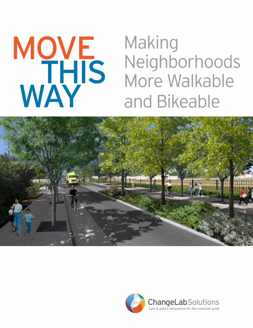
Move This Way
Making Neighborhoods More Walkable and Bikeable
ChangeLabSolutionsLaw & policy innovation for the common good.

changelabsolutions.org 1
Contents
2 Chapter 1 Introduction
6 Chapter 2 Common Local Codes & Barriers to Implementation
12 Chapter 3 Addressing Health Disparities
20 Chapter 4 Pedestrian & Bike-friendly Code Elements
73 Appendix A Resources
74 Endnotes

2 changelabsolutions.org
chapTer 1: introduction
Walking & Biking toward Healthy, Vibrant Communities
Take a moment to think about the neighborhood where
you live. Can you easily walk or bike to work? How about
to essential services, like public transportation, parks,
libraries, and grocery stores? Do you have well-maintained,
uninterrupted sidewalks and an accessible network of
bicycle facilities, such as bike lanes and trails? Are your
streets clean and attractive, with landscaping, benches,
lighting, and other features that make your journey more
pleasant? If there are children in your household, do you
feel comfortable allowing them to walk or bike to school?
If you answered “no” to many of these questions, you
are not alone. Far too many communities lack the basic
amenities that make walking and biking safe, comfortable,
and convenient. During the last half-century, urban
development has largely focused on the construction
of automobile-friendly suburban communities. Many
cities and towns built during this period have wide roads
meant to maximize car volume and speed, narrow or
absent sidewalks and hazardous street crossings, few
or discontinuous bicycle routes, and long distances
separating destinations such as home, work, shops, and
schools. Meanwhile, denser, more urban communities
also face barriers to walking and bicycling. In some
of these places, aging infrastructure and escalating
maintenance costs have left existing pedestrian, bicycle,
and public transportation amenities in bad repair, while the
suburbanization of many jobs and businesses has required
city residents to drive to work. These trends have a
profound influence on our health, economy, environment,
and overall quality of life. Among the risks to health:
Declining rates of walking and bicycling linked to increased obesity and other chronic diseases: Chances are, the more you drive, the more you weigh. In
an international survey, researchers found that the United
States has some of the lowest rates of walking, biking,
and public transportation ridership compared to other
industrialized countries, coupled with higher rates of car
usage, and found that these factors are directly correlated
with higher obesity rates.1 This trend holds within the U.S.
too: for instance, one American study showed that every
additional hour spent in a car per day is associated with
a 6 percent greater risk of being obese.2 More than two-
thirds of American adults, and almost one-third of children
and teens, are overweight or obese and thus at increased
risk for a range of health conditions, such as heart disease
and diabetes.3, 4, 5
changelabsolutions.org 3
High rates of traffic crashes resulting in injury and death: Fast speeds, heavy car volumes, and unsafe
infrastructure make our roads dangerous for everyone —
drivers, bicyclists, and pedestrians alike. On average
each day, more than 90 people are killed and more than
6,000 people are injured in traffic crashes, the majority of
whom are car drivers or passengers.6 For pedestrians and
bicyclists, the introduction of traffic safety measures (such
as traffic calming features, well-marked street crossings,
and bike lanes) have been linked to a decreased risk of
injuries and fatalities.7, 8
Health risks related to air pollution: Higher driving
rates result in poorer air quality across the region, with
various potential health consequences, such as increased
risk of asthma and other respiratory diseases, coronary
heart disease, premature births, and cancer.9, 10, 11 Air
pollution can also prevent physical activity and exacerbate
chronic conditions (for example, by triggering asthma
attacks).12 It is estimated that traffic-related air pollution
in the U.S. results in 40,000 premature deaths annually.13
Perhaps even more critically, transportation-related
emissions contribute significantly to climate change,
which could lead to major disruptions to our way of life,
endangering our health through potential increases
in extreme weather events, food and water shortages,
displacement of coastal communities, and other potential
hazards.14
Difficulties accessing vital services and destinations: Sprawling development can make it harder to access the
resources essential to a healthy lifestyle. Car owners may
find themselves spending precious time and resources
driving to the edge of their community or even farther
afield to get to work, schools, grocery stores, hospitals,
and other community institutions.15 Meanwhile, households
without cars may find themselves out of luck, especially
in communities where there are few public transportation
alternatives.
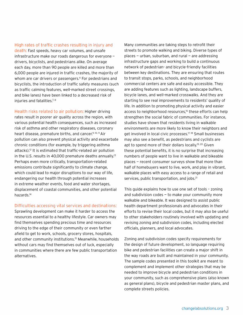
Many communities are taking steps to retrofit their
streets to promote walking and biking. Diverse types of
places — urban, suburban, and rural — are addressing
infrastructure gaps and working to build a continuous
network of pedestrian- and bicycle-friendly facilities
between key destinations. They are ensuring that routes
to transit stops, parks, schools, and neighborhood
commercial centers are safe and easily accessible. They
are adding features such as lighting, landscape buffers,
bicycle lanes, and well-marked crosswalks. And they are
starting to see real improvements to residents’ quality of
life. In addition to promoting physical activity and easier
access to neighborhood resources,16 these efforts can help
strengthen the social fabric of communities. For instance,
studies have shown that residents living in walkable
environments are more likely to know their neighbors and
get involved in local civic processes.17, 18 Small businesses
may also see a benefit, as pedestrians and cyclists are
apt to spend more of their dollars locally.19, 20 Given
these potential benefits, it is no surprise that increasing
numbers of people want to live in walkable and bikeable
places — recent consumer surveys show that more than
half of homebuyers want to live, work, and play in vibrant,
walkable places with easy access to a range of retail and
services, public transportation, and jobs.21
This guide explains how to use one set of tools – zoning
and subdivision codes — to make your community more
walkable and bikeable. It was designed to assist public
health department professionals and advocates in their
efforts to revise their local codes, but it may also be useful
to other stakeholders routinely involved with updating and
revising zoning and subdivision codes, including elected
officials, planners, and local advocates.
Zoning and subdivision codes specify requirements for
the design of future development, so language requiring
bike and pedestrian facilities can create a major shift in
the way roads are built and maintained in your community.
The sample codes presented in this toolkit are meant to
complement and implement other strategies that may be
needed to improve bicycle and pedestrian conditions in
your community, such as comprehensive plans (also known
as general plans), bicycle and pedestrian master plans, and
complete streets policies.

4 changelabsolutions.org
chapter 1: IntroductIon
Design Needs of Pedestrians & Cyclists Streets designed only for cars are dangerous for everyone
else, and they contribute to the obesity epidemic by
making it difficult for children and adults to get regular
physical activity during their daily routine. In contrast,
“complete streets” are safer, convenient, and comfortable
not only for drivers but also for pedestrians, bicyclists,
children, and people with disabilities. All modes of travel —
from walking to bicycling to public transit — must offer
safety, access, and comfort to succeed.
SafetyStreets should keep pedestrians and bicyclists safe from
potential physical harm or exposure to environmental
hazards.
Complete Streets. Forty percent22 of our roads do not
have sidewalks even though injuries and fatalities are more
likely to happen in places without sidewalks or crosswalks.
The risk of pedestrian fatalities significantly increases
to 45 percent when crosswalks are absent (compared to
10 percent when crosswalks exist).23 Studies show that
streetlights and paved surfaces prevent injuries and
crashes, enhancing safety for not only for bicyclists but
also for pedestrians and motorists.24 Safety-related street
components include sidewalks and bike lanes, pedestrian-
scaled lighting, well-spaced trees and vegetation, and
the absence of automotive-oriented uses. Frequent and
well-marked pedestrian crossings are a key feature of safe
neighborhoods.
Reducing speeds. Collisions with cars traveling 30
miles per hour result in pedestrian deaths 40 percent
of the time, compared to 5 percent of the time for
collisions with cars traveling 20 miles per hour.25 Specific
engineering features — narrower travel lanes, bulb-outs,
and roundabouts — calm traffic and enhance street
crossings, which can alleviate fears about walking and
reduce the incidence of traffic-related pedestrian injuries
and fatalities.
Safety from crime. Concern about safety is a major
barrier to walking or bicycling.26 Studies have shown a
positive relationship between safe environments and
walking, especially for children and seniors.27 Urban design
strategies that create opportunities for pedestrian activity —
ground-floor retail, daytime and nighttime uses, landmarks,
and pedestrian-scaled lighting — can create safer and more
enticing environments for pedestrians and bicyclists alike.
AccessStreet connectivity and a supportive multi-modal
transportation network are central to pedestrian- and
bicycle-friendly neighborhoods.
Compact and complete neighborhoods. Compact and
mixed-use neighborhoods bring destinations closer to
each other, reducing the need to travel long distances for
basic needs such as food, jobs, and retail. A strong mix of
land uses can attract pedestrian activity, and amenities
such as outdoor dining and landscaping can enhance
the sense of place. Parks and open space can have
significant positive impacts on health and well-being. In
addition to promoting physical activity, access to a natural
environment and green spaces can reduce stress, improve
mental health, and increase longevity.28 A study conducted
in Los Angeles showed that residents living within a mile of
a park are four times more likely to visit the park once per
week or more.29 Zoning components that directly impact
connectivity include shorter block lengths, limited cul-
de-sac use, ground-floor commercial uses, and standards
addressing parks and recreational spaces.
A multi-modal transportation network. Improved
access to public and active transportation modes can lead
to a higher quality of life through greater physical activity;
increased access to jobs, services, and retail; and reduced
transportation costs.30, 31, 32 A well-connected network of
streets, sidewalks, and paths improves transit accessibility
and makes it more likely that public transit users will walk
or bicycle.

changelabsolutions.org 5
Public sidewalks and bicycle lanes or paths should also
connect key destinations throughout the neighborhoods,
such as schools, parks, and commercial areas. Bus shelters
should be visible, shield transit riders from the elements,
and provide transit information in the form of maps or
electronic “next bus” features.
ComfortComfort often takes a back seat to safety and access when
designers consider pedestrians’ and bicyclists’ needs.
However, streets that create a comfortable and enticing
pedestrian realm increase the likelihood that people will
walk, bike, or take public transit when given the choice.
This is especially true for warmer or humid climates where
active forms of transportation can be more taxing.
Cultivating a sense of safety and well-being for
pedestrians and bicyclists means providing pedestrian-
scaled streetscapes (e.g., lighting and signage), aesthetic
enhancements (e.g., public art or well-maintained
landscape features), and amenities (e.g., abundant seating,
bus shelters, or water features). It is equally important to
eliminate elements that make streets feel less safe, such
as surface parking lots, abandoned lots, or excessively
long street walls.

6 changelabsolutions.org
What is zoning? Zoning is the mechanism by which cities and counties
regulate how parcels of land can be developed — both the
types of uses allowed and the features of the physical
structures that can be built. Zoning works by legally
dividing a jurisdiction (a city or a county) into separate
geographic districts or “zones” and then applying different
rules or regulations that govern the built environment
within each zone. Zoning codes generally determine what
types of structures can be located in each zoning district
(e.g., how large or small a structure can be, how tall, etc.)
and how structures within the district can be used (e.g.,
residential, commercial, industrial, etc.).
How are zoning codes created?Zoning generally takes place at the local level. Zoning
codes are created legislatively, meaning that they have
to be voted on by the city council or county board of
supervisors. Each jurisdiction has a zoning code within its
municipal code (for a city) or county code that creates the
overall zoning map for the jurisdiction, as well as the rules
that apply within each zoning district. To make changes
to the zoning district map or to the zoning regulations
within a district, the legislative body has to vote to pass an
ordinance to amend the zoning code. Once an ordinance
is passed, it becomes law, and the zoning code is amended
accordingly.
Zoning Codes
chapTer 2: common Local codes & Barriers to implementation

changelabsolutions.org 7
In some states, such as California, ordinances that amend
the zoning code can be adopted through a ballot initiative
process. Under this process, a measure is placed on the
ballot in a local election, and if it garners a majority of
votes, it becomes law, just as it would if a legislative body
had passed the ordinance. A measure can be placed
on the ballot by the local legislative body or through a
petition process whereby the proponents of the measure
collect a specified number of signatures from voters in the
jurisdiction.
How does zoning affect pedestrian- and bicycle-oriented design?Zoning codes have a big influence on how pedestrian-
friendly or bike-friendly a community is. Not only do
zoning codes create rules about the size, location, and use
of buildings within a zoning district, but they also govern
the surrounding public spaces. For example, zoning codes
set standards for the width of sidewalks and streets, the
location and frequency of crosswalks, the placement of
pedestrian medians, the installment of bicycle lanes, or
the inclusion of traffic-calming devices such as speed
bumps. Zoning codes can also create mixed-use districts
where structures can be used for both commercial and
residential purposes, allowing more commerce to happen
where people live and reducing the need for motor
vehicles. Zoning can even foster greater socioeconomic
diversity in communities by requiring a proportion of all
newly constructed housing units to be affordable to low-
income residents. This is called “inclusionary zoning” or
“inclusionary housing.”
Zoning codes can create active, vibrant, and compact
neighborhoods by allowing, requiring, restricting, and
incentivizing an array of uses. For example, allowing
community gardens, farmers’ markets, or edible
landscaping in residential, institutional, or open space
ensures access to healthy and nutritious food in
neighborhoods where grocery stores are not present or
easily accessible. On the other hand, restricting fast food
restaurants ensures that unhealthy foods are prohibited
in certain areas, especially around schools, parks, or day
care centers. Many municipalities utilize incentives to
encourage developers to provide features that promote
the public good. For example, a zoning code may allow a
reduction on the parking spaces a developer is required to
provide in exchange for a park or community center.
What are the legal limitations and requirements for zoning to be valid?To be legally valid, zoning codes have to be reasonably
related to the public welfare, they must comply with
all constitutional requirements such as due process,
and in many states (including California, Minnesota,
Pennsylvania, and Wisconsin, among others) they must
be consistent with the comprehensive or general plan of
the jurisdiction. In addition, zoning may run afoul of the
law when it has a disproportionately adverse impact on
specific protected classes of people, such as minorities
or immigrant populations. In general, any ordinance to
amend a zoning code will include a series of “findings”
that outline the rationale for the proposed changes,
demonstrating that they are reasonably related to the
public welfare, consistent with the comprehensive plan,
and not discriminatory or otherwise unconstitutional.

8 changelabsolutions.org
What are subdivision codes?A subdivision is a tract of land that has been divided
into multiple parcels or lots, but which remain legally
grouped together for purposes of a specific development.
In contrast to zoning codes, which regulate the type and
intensity of uses allowed on a parcel of land, subdivision
codes regulate how land is divided to accommodate uses
permitted by the zoning code. Just as they have zoning
codes, cities and counties also have subdivision codes that
govern the process for subdividing land and establish the
types of infrastructure to be provided to new plots. For
example, subdivision codes can require residential lots to
have a minimum level of access to public roads and utilities
and can regulate how many residential or commercial
units may be sited on one parcel. Subdivision codes can
also govern how land is developed; for example, they can
require buildings to be placed a certain distance from
the street or can regulate the amount of space between
buildings. This can determine the type of development a
subdivision can be used for (for example, as a shopping
area, a tract of single family homes, office buildings, etc.).
How do subdivision codes affect pedestrian- and bicycle-oriented design?Because subdivision codes regulate the types of services
that must be available to units in a subdivision, there are
a number of ways that subdivision codes can facilitate
pedestrian- or bike-friendly design. For example, subdivision
codes can require that a percentage of lots within a
subdivision have access to a bike lane, or they can set
standards for sidewalk width on roads that abut residential
or commercial lots within a subdivision. Subdivision codes
can also foster greater density within subdivisions and can
determine the development of combined commercial and
residential structures within the same subdivision. Similar
to mixed-use zoning, this kind of development reduces the
distance that residents have to travel to access services,
decreasing their dependence on motor vehicles and making
walking and cycling more attractive.
How are subdivision codes created?Just as with zoning codes, amendments to a municipality’s
subdivision code are made legislatively, through an
ordinance passed by a city council or county board of
supervisors.
What are the legal limitations and requirements for subdivision codes?Local subdivision codes must abide by all relevant state
laws governing subdivisions. For example, California’s
Map Act (which creates the rules for how land can be
subdivided) requires municipalities to have a subdivision
code to regulate subdivisions in its jurisdiction, but the
Map Act preempts local regulations that contradict the
provisions of the Map Act itself.33 Amendments to a
subdivision code that affect or change the way land or
a subdivision can be used must also meet constitutional
requirements of due process. This means that the changes
to the code must not result in arbitrarily depriving
someone of a property interest without a sufficiently
legitimate reason. Furthermore, changes that substantially
alter the value of private property may constitute a
“taking,” which requires the government to compensate
property owners for their loss in value.
Subdivision Codes
chapTer 2: coMMon LocaL codes & Barriers To iMpLeMenTaTion

changelabsolutions.org 9
Increasingly, jurisdictions have begun to combine their
zoning and subdivision codes (and in some cases, other
codes such as the building code) into a unified land
development code.
Unified development codes are enacted through the
same legislative process described above for zoning
and subdivision codes. Consolidating local zoning and
subdivision codes into one unified development code
does not change the legal requirements for adopting
zoning or subdivision provisions, nor does it change
the legal limitations and requirements that apply to
those provisions, as discussed in the previous sections.
Combining the relevant codes in one place makes it easier
to work within the framework of the comprehensive plan.
In jurisdictions where zoning and subdivision codes are
legally required to be consistent with the comprehensive
plan, consolidation helps ensure that the codes comply
with that law.
Unified Development Codes
10 changelabsolutions.org
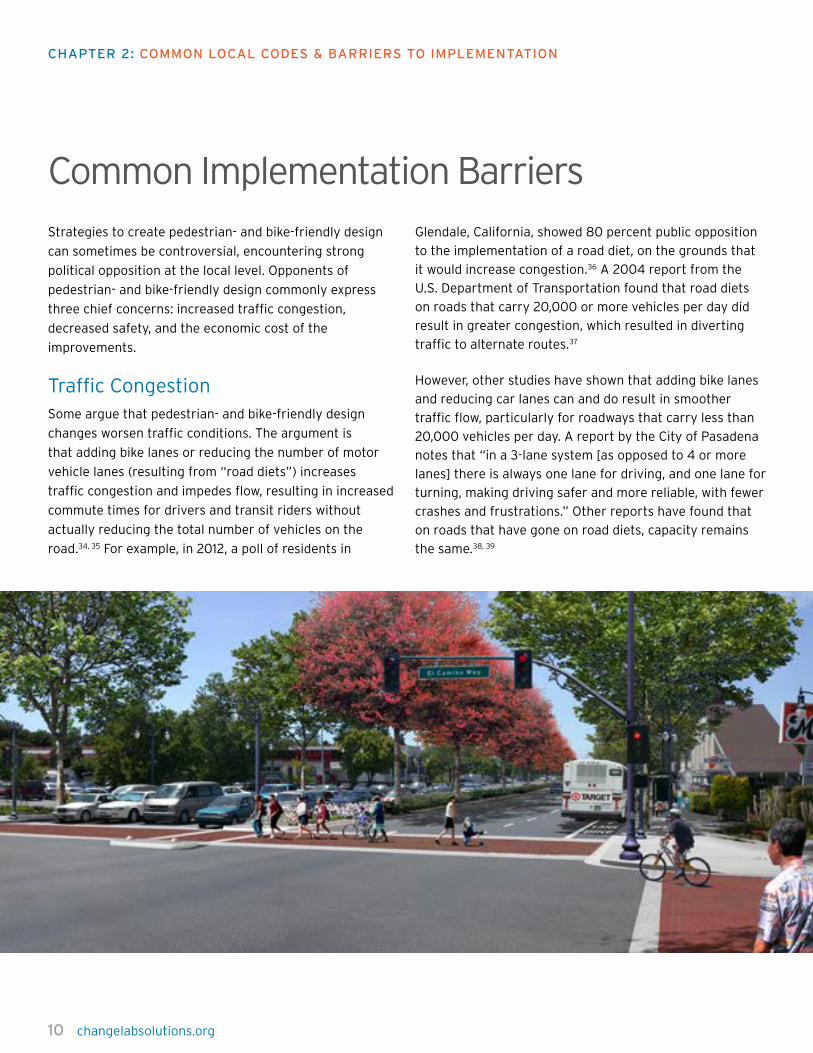
Strategies to create pedestrian- and bike-friendly design
can sometimes be controversial, encountering strong
political opposition at the local level. Opponents of
pedestrian- and bike-friendly design commonly express
three chief concerns: increased traffic congestion,
decreased safety, and the economic cost of the
improvements.
Traffic CongestionSome argue that pedestrian- and bike-friendly design
changes worsen traffic conditions. The argument is
that adding bike lanes or reducing the number of motor
vehicle lanes (resulting from “road diets”) increases
traffic congestion and impedes flow, resulting in increased
commute times for drivers and transit riders without
actually reducing the total number of vehicles on the
road.34, 35 For example, in 2012, a poll of residents in
Glendale, California, showed 80 percent public opposition
to the implementation of a road diet, on the grounds that
it would increase congestion.36 A 2004 report from the
U.S. Department of Transportation found that road diets
on roads that carry 20,000 or more vehicles per day did
result in greater congestion, which resulted in diverting
traffic to alternate routes.37
However, other studies have shown that adding bike lanes
and reducing car lanes can and do result in smoother
traffic flow, particularly for roadways that carry less than
20,000 vehicles per day. A report by the City of Pasadena
notes that “in a 3-lane system [as opposed to 4 or more
lanes] there is always one lane for driving, and one lane for
turning, making driving safer and more reliable, with fewer
crashes and frustrations.” Other reports have found that
on roads that have gone on road diets, capacity remains
the same.38, 39
Common Implementation Barriers
chapTer 2: coMMon LocaL codes & Barriers To iMpLeMenTaTion
changelabsolutions.org 11
SafetyOpponents to pedestrian- and bike-oriented development
sometimes argue that such strategies decrease overall
safety for pedestrians, cyclists, and drivers alike and that
bike lanes in some cases actually make cyclists less safe.
One article from 2008, for example, argues that locating
bike lanes on the right side of the road creates a hazard
for cyclists, increasing the likelihood that they will be cut
off by cars attempting to turn.40
Proponents point to studies that contradict this argument,
showing overall increased safety with bike lanes and
pedestrian improvements. For example, one 2012 study
found that the installation of bicycle lanes in New York
City did not lead to higher rates of collisions and theorized
that the slowing of traffic increases safety.41 Another study
from 2009 concluded that improvements such as bike
lanes, increased street lighting, paved surfaces, and low-
angled grades contribute to overall safety.42
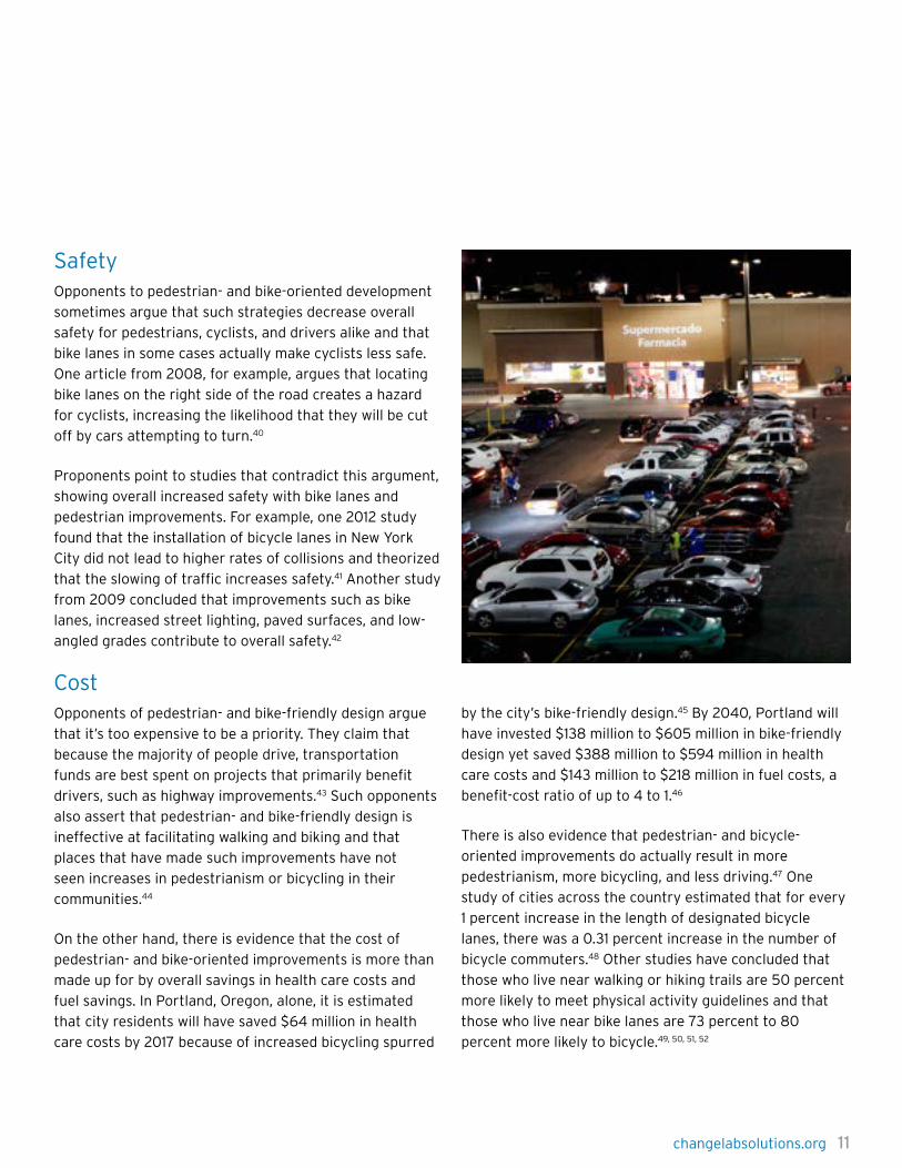
CostOpponents of pedestrian- and bike-friendly design argue
that it’s too expensive to be a priority. They claim that
because the majority of people drive, transportation
funds are best spent on projects that primarily benefit
drivers, such as highway improvements.43 Such opponents
also assert that pedestrian- and bike-friendly design is
ineffective at facilitating walking and biking and that
places that have made such improvements have not
seen increases in pedestrianism or bicycling in their
communities.44
On the other hand, there is evidence that the cost of
pedestrian- and bike-oriented improvements is more than
made up for by overall savings in health care costs and
fuel savings. In Portland, Oregon, alone, it is estimated
that city residents will have saved $64 million in health
care costs by 2017 because of increased bicycling spurred
by the city’s bike-friendly design.45 By 2040, Portland will
have invested $138 million to $605 million in bike-friendly
design yet saved $388 million to $594 million in health
care costs and $143 million to $218 million in fuel costs, a
benefit-cost ratio of up to 4 to 1.46
There is also evidence that pedestrian- and bicycle-
oriented improvements do actually result in more
pedestrianism, more bicycling, and less driving.47 One
study of cities across the country estimated that for every
1 percent increase in the length of designated bicycle
lanes, there was a 0.31 percent increase in the number of
bicycle commuters.48 Other studies have concluded that
those who live near walking or hiking trails are 50 percent
more likely to meet physical activity guidelines and that
those who live near bike lanes are 73 percent to 80
percent more likely to bicycle.49, 50, 51, 52

12 changelabsolutions.org
Our built, social, and economic environments have a
tremendous impact on our health, and increasingly
we must grapple with the reality that health risks and
resources are not distributed evenly. Communities with
higher concentrations of low-income people and people
of color are more likely to face unhealthy conditions, such
as environmental pollution, dangerous traffic patterns,
neighborhood crime, low-quality housing, and high
numbers of fast food outlets and liquor stores.53 These
communities typically have less access to good schools,
stable employment, affordable health care, safe parks
and recreational spaces, places to buy healthy food, and
meaningful opportunities for civic engagement.54 Such
discrepancies in resources can amount to staggering
differences in health; for instance, a child born into
poverty is seven times more likely to report poor health
than a child born to a wealthier family, and can expect to
die 6.5 years sooner on average.55
Although it is important to improve walking and biking
amenities in all communities, to ensure lasting progress
in tackling our chronic disease epidemic, we must pay
special attention to the communities where health needs
are greatest. Low-income people, rural communities,
seniors, people with limited mobility, and other vulnerable
populations face particular challenges to living a healthy
lifestyle, including the following:
Neighborhoods without access to healthy resources: Low-income households and people with limited mobility
are less likely than others to own a private vehicle and
more likely to use “active transportation” modes such
as walking, biking, and public transportation.56 While this
may promote increased physical activity, such potential
benefits are offset by the lack of healthy options within
the immediate community. Low-income neighborhoods
often lack the resources essential to health, such as
employment centers, grocery stores, recreational facilities,
healthcare providers, and other civic institutions.57
Residents may face difficult choices if these resources
are too far away to access by biking and walking and
there are no convenient transit routes. For instance, only
about one-quarter of low- and middle-skilled jobs are
within a 90-minute ride on public transit for commuters in
metropolitan areas, meaning that low-income people may
have to spend significant amounts of time and money to
reach appropriate jobs.58 In communities without grocery
stores or other places to buy healthy food, residents may
rely on poor-quality, unhealthy food at local convenience
stores and restaurants, or they may have to take a difficult
journey on transit to get to farther-flung stores.59 For
many, these transportation barriers are prohibitive: for
example, it’s estimated that more than half a million
Americans with disabilities almost never leave their
homes because they do not have access to reliable public
transportation options.60
Lower-quality and unsafe bicycle and pedestrian infrastructure: Low-income communities are more
likely to lack amenities that make biking and walking
comfortable and safe.61 For example, 89 percent of
high-income neighborhoods have adequate sidewalks,
compared to 59 percent of middle-income neighborhoods
and 49 percent of low-income neighborhoods. The
same pattern holds for other types of infrastructure:
13 percent of high-income communities have marked
crosswalks versus 7 percent of low-income communities,
while 8 percent of high-income communities have traffic-
calming features, compared to 3 percent of low-income
communities.62 Low-income communities may also see
greater delays in maintenance and upgrades relative to
more wealthy communities.63
These conditions contribute to the higher rates of traffic
crashes and fatalities in lower-income communities.
Nationally, the number of pedestrians injured in the
poorest census tracts is more than six times higher than
in the richest census tracts.64 The story is similar for
Health & Equity
chapTer 3: addressing health disparities

changelabsolutions.org 13
cyclists — the number of injuries is almost four times higher
in poor areas than in rich ones.65 Neighborhoods that feel
unsafe — because of dangerous traffic conditions or high
crime rates, both of which are more prevalent in low-
income communities — also discourage residents from biking,
walking, and other outdoor physical activities, preventing
people from making all but the most essential trips.66
Unsupportive land use policies and fewer opportunities to get involved: Many of the communities
that experience the greatest health disparities also tend
to have lower rates of participation in political and civic
processes, which can be exacerbated by linguistic, cultural,
and educational barriers. Thus, residents may have fewer
opportunities to voice concerns about transportation
issues facing their communities.67
Urban planning policies reflect these disparities in
political participation. Even though more residents bike
and walk in lower-income communities, these areas
are less likely to have zoning or subdivision codes that
require pedestrian- or bicycle-friendly infrastructure than
upper-income communities are.68 Ninety-one percent of
high-income communities require pedestrian-oriented
design elements such as sidewalks, crosswalks, and so
on. But only 58 percent of low-income communities have
such requirements. Similarly, 14 percent of higher-income
communities have laws that mandate bike lanes, but only
5 percent of low-income communities do.69
Many of these poorer neighborhoods are also dealing with
incompatible land uses, such as residences located near
polluting industrial and waste facilities. Zoning codes may
not require developers to provide basic infrastructure for
walking and biking for properties zoned for industrial/
manufacturing or mixed-use.70
Mobility challenges in rural and exurban areas: Rural
communities face particular health challenges, with higher
mortality rates and a greater incidence of many chronic
and acute diseases.71 With large distances separating
destinations, lower population densities, and fewer
resources to invest in infrastructure, rural towns may
struggle to provide even the most basic pedestrian and
bicycle facilities, and public transportation service may be
meager or nonexistent. About 40 percent of people living
in rural areas — over 12 million people — live in counties
without public transportation.72 Low-income people,
seniors, and those with limited mobility are especially
vulnerable in rural areas; they face a higher risk of social
isolation and even less access to health-promoting goods
and services than residents in denser communities.73
Pedestrian- and bicycle-friendly infrastructure alone
cannot solve these persistent health disparities; helping
communities hardest hit by chronic, preventable illness will
require a comprehensive range of policies and programs,
as well as social, educational, and economic support that
provides residents with both the knowledge and the means
to lead healthier lives. Yet targeted investments to improve
walking and bicycling conditions for vulnerable populations
can have a noticeable impact on residents’ health. In fact,
since lower-income and other vulnerable populations
are more dependent on walking and biking, the impact
of these improvements may be felt more deeply there
than in other communities. The benefits extend beyond
health — improvements that increase walking and biking
can improve quality of life for local residents, reduce our
environmental footprint, and help revitalize neighborhoods
and the local economy.

14 changelabsolutions.org
chapTer 3: addressing heaLTh dispariTies
Zoning Strategies to Address Health Disparities
Creative approaches to zoning and subdivision codes show
great potential to address past inequities. This section
describes a few zoning tools (zoning changes, buffers/
overlays, and inclusionary zoning), while the following
section outlines some policy strategies that promote
health equity. Depending on your local context and your
state’s laws, it may make sense to get involved in a policy
strategy in addition to, or instead of, working on your
community’s zoning codes. For example, your community
can develop a stand-alone Complete Streets resolution
or integrate active transportation policies into your
Comprehensive or General Plan. As the primary land use
document, a community comprehensive plan contains
policies and implementation strategies that guide the way
a community takes shape. See Appendix A for links to
resources that can help you implement these strategies.
Zoning has two components: 1) a zoning map, which
specifies categories of places (“zones”), down to
the individual parcel; and 2) a zoning ordinance (aka
“zoning code”), which specifies the requirements
that apply to properties in each zone. A basic zoning
ordinance specifies permitted, conditionally permitted, and
restricted uses for all parcels within a given zone, as well
as other requirements for how the land may be built out
(such as building height limits, setback requirements, and
other design guidelines).
Zoning changesOne way a community could address health disparities
is to redraw its map boundaries. For example, most
communities assume that few pedestrians and bicyclists
will travel through areas zoned for industrial uses, so
they may not include requirements for basic bicycle and
pedestrian amenities in such zones. But if a community
has a concentration of low-income households in a “light
industrial” zone that borders an area zoned “residential,”
residents could request to change these parcels to
residential zoning to qualify for pedestrian- and bicycle-
friendly features.
The existing land use context is critical — a proposal to
change zoning designations may be less likely to pass
if the new zoning is substantially different, and a large
number of properties will become “non-conforming”
uses (for example, a recycling facility in a new residential
zone could be considered non-conforming). One way
to deal with this issue is to “grandfather” these non-
conforming properties, allowing them to continue their
operations until they substantially change the nature
of their activities. However, map amendments may
be most feasible in neighborhoods with many vacant
or undeveloped parcels or in communities that are
conducting a more comprehensive zoning revision that
includes extensive zoning changes across the jurisdiction.
A community could also amend the text of its zoning
ordinance to add requirements and incentives that address
health disparities. For example, a community could decide
to change its zoning code for “medium residential” zones
to require that apartment buildings provide a minimum
number of bike parking spaces. Such a change would
impact all properties across the jurisdiction that fall within
the “medium residential” zone. Even though this is a
rather blunt tool (impacting the entire jurisdiction), it can
still address disparities affecting specific neighborhoods
or groups. For example, we might reasonably assume
that multi-family apartment buildings are more likely to
house low-income households that do not own cars. Thus,
the code amendment to add bike parking spaces would
likely have a greater impact for low-income residents
but would have the added benefit of improving quality of
life for everyone who lives in multi-family housing in the
community.

changelabsolutions.org 15
Creating new health-supporting zoning designations Once communities are built out, it may be challenging to
create substantial changes to prevailing land use patterns.
For instance, many suburban communities have been
developed with a strict division of land uses — wholly
separated zones for single-family homes, multi-family
homes, commercial, institutional, and industrial properties,
which has disconnected residential neighborhoods from
daily necessities. In this context, standard zoning code and
map amendments may not be sufficient to transition to
new, more livable development patterns.
Planners are trying to create more flexibility within
this system through new zones, buffers, and overlays
that respond to arising needs or priorities. For instance,
many communities are developing transit-oriented district
(TOD) zones around major public transportation hubs,
or pedestrian-oriented overlays around neighborhood
shopping centers. These more targeted forms of zoning
may also help to address health disparities, since they can
be applied to limited areas where the barriers to health
are greatest. See the case study on Baltimore’s TransForm
rezoning process (page 19), an example of a community
experimenting with buffer and overlay zoning tools to
address health needs.
These tools can be used interchangeably to some
degree, but they do have a few differences. Planners
can use new zoning to signal a departure from current
zoning (such as a new mixed-use zone) or to tailor more
general regulations to a specific neighborhood. Zoning
overlays, which are quite common for habitat and historic
preservation, can generally serve a similar purpose, but as
the name implies, they’re a set of policies that build upon
the existing underlying zoning with additional (usually
more specific or stricter) requirements. Zoning buffers
tend to improve transitions between existing zones,
which may be an especially useful strategy for residential
communities in close proximity to industrial facilities or
freeways. In practice, selecting the appropriate tool to
use may depend on the specific outcomes desired, the
local planners’ familiarity with these tools, and political
feasibility.

16 changelabsolutions.org
chapTer 3: addressing heaLTh dispariTies
Zoning for health in all neighborhoods, not just vulnerable communitiesIn many places, neighborhoods may be heavily segregated
by income, education, and race, and zoning maintains
these exclusionary practices. For example, some higher-
income neighborhoods have zoning requirements that
specify minimum house and lot sizes, which can prohibit
the development of smaller or multi-family buildings.
Residential segregation and concentrated poverty can
lead to deepening health disparities — as communities
become increasingly divided, low-income communities
may suffer through lack of revenues, lower-quality schools,
and less engagement in civic processes. These trends
have accelerated during the last half-century, as wealthier
households have moved out of central cities to suburban
and exurban communities.74 (Evidence indicates that this
trend may now be reversing in many regions.75)
It is critical to look beyond the neighborhoods most
burdened by health disparities to ensure that zoning codes
everywhere foster diverse communities, with housing and
economic opportunities across the income spectrum. One
effective tool that promotes neighborhood diversity
is inclusionary zoning, which uses requirements and
incentives to induce developers to produce affordable
housing when new projects are developed. To ensure
health equity, it is especially critical that such policies
prioritize housing in neighborhoods that are rich in public
transportation, bicycle, and pedestrian amenities.
Inclusionary zoning can serve multiple functions. In more
prosperous neighborhoods, it can create new housing
opportunities for less well-off residents. Meanwhile, in
lower-income neighborhoods where housing prices are
relatively low, inclusionary zoning can result in newer
and higher-quality affordable units and can help preserve
affordable housing supplies (which is particularly
important in neighborhoods where rising property values
threaten to displace existing residents). Many communities
adopt a jurisdiction-wide inclusionary zoning code that
affects both higher- and lower-income neighborhoods;
however, some areas opt for targeted inclusionary
strategies using overlays or specific zones.
Inclusionary strategies may be especially effective as
part of subdivision codes, especially if you live in an area
where the majority of new housing is built in subdivisions.
Historically, subdivisions have tended to provide limited
types of housing (such as large, single-family detached
homes) at prices that are unaffordable to many low- and
moderate-income buyers. Inclusionary housing strategies
can ensure that new developments provide a diversity of
housing types and prices.
Strategies to create healthier and more diverse
communities can benefit everyone, not just low-income or
other vulnerable groups. Although studies on the subject
remain rare, some evidence is beginning to emerge that
demand is growing for communities that are economically
and socially diverse and that social interactions among
diverse groups in community settings (such as schools)
can help build social capital.76
changelabsolutions.org 17
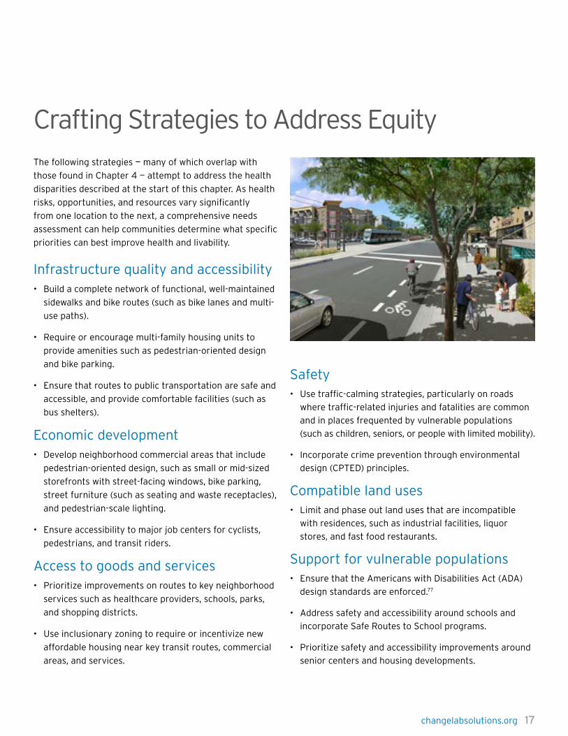
Crafting Strategies to Address Equity The following strategies — many of which overlap with
those found in Chapter 4 — attempt to address the health
disparities described at the start of this chapter. As health
risks, opportunities, and resources vary significantly
from one location to the next, a comprehensive needs
assessment can help communities determine what specific
priorities can best improve health and livability.
Infrastructure quality and accessibility• Build a complete network of functional, well-maintained
sidewalks and bike routes (such as bike lanes and multi-
use paths).
• Require or encourage multi-family housing units to
provide amenities such as pedestrian-oriented design
and bike parking.
• Ensure that routes to public transportation are safe and
accessible, and provide comfortable facilities (such as
bus shelters).
Economic development• Develop neighborhood commercial areas that include
pedestrian-oriented design, such as small or mid-sized
storefronts with street-facing windows, bike parking,
street furniture (such as seating and waste receptacles),
and pedestrian-scale lighting.
• Ensure accessibility to major job centers for cyclists,
pedestrians, and transit riders.
Access to goods and services• Prioritize improvements on routes to key neighborhood
services such as healthcare providers, schools, parks,
and shopping districts.
• Use inclusionary zoning to require or incentivize new
affordable housing near key transit routes, commercial
areas, and services.
Safety• Use traffic-calming strategies, particularly on roads
where traffic-related injuries and fatalities are common
and in places frequented by vulnerable populations
(such as children, seniors, or people with limited mobility).
• Incorporate crime prevention through environmental
design (CPTED) principles.
Compatible land uses• Limit and phase out land uses that are incompatible
with residences, such as industrial facilities, liquor
stores, and fast food restaurants.
Support for vulnerable populations• Ensure that the Americans with Disabilities Act (ADA)
design standards are enforced.77
• Address safety and accessibility around schools and
incorporate Safe Routes to School programs.
• Prioritize safety and accessibility improvements around
senior centers and housing developments.

18 changelabsolutions.org
chapTer 3: addressing heaLTh dispariTies
Incorporating Health Equity Throughout the Zoning Process
In practice, the zoning strategies described in this chapter
represent a set of tools to help create environments
that promote health equity, but they are not a panacea.
Jurisdictions are unlikely to make progress on reducing
health disparities unless there is a collaborative,
community-wide effort that leverages the existing
strengths, knowledge, and resources of many stakeholders.
Here are some questions that can help frame discussions
throughout this process, from the initial assessment phase
through the implementation rollout:
Assess current health needs and barriers• Where are the areas with the greatest health needs? If
it has not already been completed, an assessment of the
built environment, such as a walk audit or bike audit,
can highlight problem areas.
• How are communities that are most underserved by
bicycle and pedestrian infrastructure currently zoned?
How does the existing policy prevent people from being
healthy?
Conduct outreach and develop partnerships• What groups/people do we need to reach out to in order
to ensure that diverse populations are represented
(such as community groups, businesses and business
associations, health and social services agencies, or
other government agencies)?
• Who is likely to support the policy? How can we engage
them?
• Who is likely to oppose the policy, and why? What health
messages or priorities might resonate with them?
Develop policies to address disparities• What agencies or people will implement the policy?
• What performance measures can be included to
ensure success and accountability? Consider diverse
health, economic, and social indicators. A Health
Impact Assessment (HIA) may be one way to develop a
comprehensive understanding of the potential benefits
or negative consequences of a policy.
• How can we set up the policy for success during the
implementation process? For instance, can we utilize
existing programs/resources, or design the policy to be
cost-neutral or to generate revenue?
Stay engaged during implementation• Which individuals or organizations will continue to
monitor implementation? What resources do they need?
• How can we ensure that the plans don’t sit on a shelf?
What sorts of implementation tools (such as capital
implementation lists) do we need to keep track of?
• Moving forward, how can we integrate our efforts with
other local/regional transportation planning initiatives?
changelabsolutions.org 19
For the first time in 40 years, Baltimore has taken a unique and healthy approach to updating its zoning code using a Health Impact Assessment (HIA) to evaluate and refine the first draft of the revised code, which is called TransForm Baltimore.78 Led by researchers from Johns Hopkins School of Medicine and School of Public Health, this HIA allowed diverse stakeholders to identify zoning strategies that might improve health issues such as obesity and related chronic diseases. Baltimore has stark health disparities across neighborhoods, with average life expectancy varying from 63 to 83 years. The HIA researchers suggest that differences in local infrastructure, which are influenced significantly by zoning, may be among the complex factors that compromise the health of lower-income and African-American communities.
By combining scientific research with local expertise, researchers identified key strategies to address disparities in local infrastructure. These strategies include expanding opportunities for physical activity, increasing the number of mixed-use developments, creating more pedestrian- and bicycle-friendly neighborhoods, and developing transit-oriented development (TOD) districts. To ensure that the new code is effective in addressing community concerns, city planners talked to a wide range of stakeholders, including city agencies, developers, community leaders, and the general public through a robust community engagement process.79 The HIA was initiated to support this process and has been a powerful tool for raising public health concerns, many of which are reflected in the draft TransForm Baltimore zoning code.
The proposed zoning references public health in its purpose statement, retains or improves design standards that promote walkability and pedestrian safety, lays out requirements for bicycle parking, and specifies districts that support TOD in high-poverty neighborhoods.80 For any
development or redevelopment affecting more than 5,000
square feet, new landscaping and design requirements
call for clear and safe pedestrian and bicycle routes
and pedestrian-friendly environments.81 Developers of
new buildings will have to provide a minimum number
of long-term covered spaces and short-term spaces for
bikes; this will apply to a wide range of facilities, including
sports arenas, schools and college campuses, apartment
buildings, and shopping centers.82 To incentivize further
increases in bicycle parking, the plan allows developers
to cut one automobile parking space for every 12 bicycle
spaces added.83 TOD districts also require a minimum of
one bicycle parking facility for every 15 parking spaces.84
Additionally, TOD districts will allow for higher residential
density mixed with retail uses near public transit hubs.
The goal is to promote the development of neighborhoods
that people can navigate using active transportation,
thereby creating greater opportunity for people to get
out of their cars and instead walk, bike, or take transit to
work, shop, and play. Four distinct TOD designations will
ensure that the new development suits the surrounding
neighborhoods. Each district will be defined by height and
retail mix allowances. For example, a TOD1 district will have
low-rise buildings and retail that’s limited to neighborhood
services, while a TOD4 district will feature taller buildings
and a full retail mix compatible with downtown locations.85
As part of the Waterfront Overlay District, the city has
included incentives for increased waterfront access and a
continuous promenade in non-industrial areas.86
Many of these tools will increase walking, biking, and
recreation, particularly in low-income communities. One
projected outcome of the new code is that 23 percent of
residents in high-poverty neighborhoods will now live in
a TOD district, with walkable access to shopping, public
transportation, and bicycle infrastructure.
TransForm Baltimore: Advancing health through the rezoning process using a Health Impact Assessment

20 changelabsolutions.org changelabsolutions.org 21
CHAPTER 4: Pedestrian- & Bike-Friendly Code Elements
Neighborhood Building Blocks
AccessActivity Center
Block Patterns
Buildings ComfortCommunity Character
ConnectivityEnvironmental
Co-benefitsGreen
StreetsLand Use Parking
Public Transportation
SafetyStreet
CrossingsTraffic Flow TOD Wayfinding
Sam
ple
Co
de
Ele
me
nts
Bicycle Infrastructure: Parking • • • • • • • • •
Bicycle Infrastructure: Separated Trails & Paths • • •
Bicycle Infrastructure: Showers & Lockers • • • • •
Building Entries • • • • •
Building Facades • • • •
Dead Space • • • • • •
Eyes on the Street • • • • •
Land Use: Commercial • • • • • •
Land Use: Density • • • •
Land Use: Mix • • • • •
Land Use: Undesirable Uses
Landmarks • • • • • • • •
Lighting • • • •
Outdoor Dining • • • • • •
Parks & Recreation Spaces • • • •
Public Art • • • • •
Sidewalks • • • • • • • •
Signage • • • •
Street Furniture • • • • • • •
Street Walls • • • •
Streets: Block Length • • • • • • •
Streets: Connectivity • • • • • •
Streets: Road Widths • • • • • •
Streets: Safe Crossings • • • • • • •
Streets: Traffic Buffers • • • • • • •
Steets: Traffic Calming • • •
Streets: Trees • • • •
Transit: Access • • • • •
Transit: Facilities • • • •
Underground Utilities • • •
Water Features • • • • • • • •
31 Codes at a Glance
Note: The sample codes in this chapter are quoted verbatim. All typos and unclear wording come directly from the codes being quoted.

22 changelabsolutions.org
Not only does bicycling provide a healthy dose of
exercise, but it also improves air pollution and congestion.
Increasing the proportion of trips taken by bicycle can
help mitigate climate change by reducing emissions of
greenhouse gases. However, a lack of bike parking can
dissuade potential riders. A survey conducted by the New
York City Planning Department (2006) found that the two
most often cited barriers to bicycle commuting are traffic
and lack of bike parking or storage.
Providing comprehensive infrastructure — including bicycle
parking — is key to cultivating bicycle-friendly communities
across the country. To encourage bicycle travel, many
communities have started to provide safe, adequate, and
convenient bicycle parking at important destinations like
commercial areas, public spaces, and major transportation
hubs. Please consult Appendix A for a comprehensive
model bike parking ordinance.
Code ExamplesIn Minneapolis, the code provides bicycle parking
guidance for downtown districts, requiring at least one
bicycle parking space for every 20 automobile spaces.
Tucson, Arizona’s code requires builders to provide bike
parking when renovating properties or expanding existing
uses, and bike parking is commonly required for new
development. Adding bike parking during renovations or
expansions is particularly important for cities that are
substantially built out.
Minneapolis, Minnesota
(b) Bicycle parking standards. Each required bicycle
parking space must be accessible without moving
another bicycle and its placement shall not result in a
bicycle obstructing a required walkway. Bicycle racks
shall be installed to the manufacturer’s specifications,
including the minimum recommended distance from other
structures. In addition:
(1) Required short-term bicycle parking spaces shall be
located in a convenient and visible area within fifty (50)
feet of a principal entrance and shall permit the locking of
the bicycle frame and one (1) wheel to the rack and shall
support a bicycle in a stable position without damage to
the wheels, frame or components. With the permission
of the city engineer, required bicycle parking may be
located in the public right-of-way. Public bicycle parking
spaces may contribute to compliance with required bicycle
parking when located adjacent to the property in question.
(2) Required long-term bicycle parking spaces shall be
located in enclosed and secured or supervised areas
providing protection from theft, vandalism and weather
and shall be accessible to intended users. Required
long-term bicycle parking for residential uses shall not
be located within dwelling units or within deck or patio
areas accessory to dwelling units. With permission of the
zoning administrator, long-term bicycle parking spaces for
non-residential uses may be located off-site within three
hundred (300) feet of the site.
Minneapolis, Minn., Zon Code Title 20, ch. 541, art. III.
§ 541.180(b)
Tuscon, Arizona
3.3.2 APPLICABILITY. The provisions of this Division
apply to:
3.3.2.1 New development.
3.3.2.2 New uses locating in an existing development, as
required in Sec. 3.3.3.11.
3.3.2.3 Any expansion of an existing use or any addition
of a new use to an existing development, as required in
Sec.3.3.3.12.
Tucson, Ar., Land Use Code, Art. III, Div. 3, § 3.3.2
Bicycle Infrastructure: Parking
chapTer 4: pedesTrian & Bike-FriendLy code eLeMenTs

24 changelabsolutions.org
Infrastructure designed and located specifically for
pedestrian and cyclist use is important to ensuring
accessible, safe, and comfortable travel, especially
in highly trafficked thoroughfares. A bicycle survey
conducted by the New York Planning Department found
that a majority of cyclists (76 percent) preferred off-street
(separated) to on-street bike facilities.
Code ExamplesIn Conyers, Georgia, policies aimed at increasing livability,
sustainability, and walkability are codified in the Zoning
Code through the Livable Centers Initiative Overlay
District. The excerpt highlights implementation strategies
for increasing pedestrian and bicycle use and connectivity
through 30-foot multi-use paths.
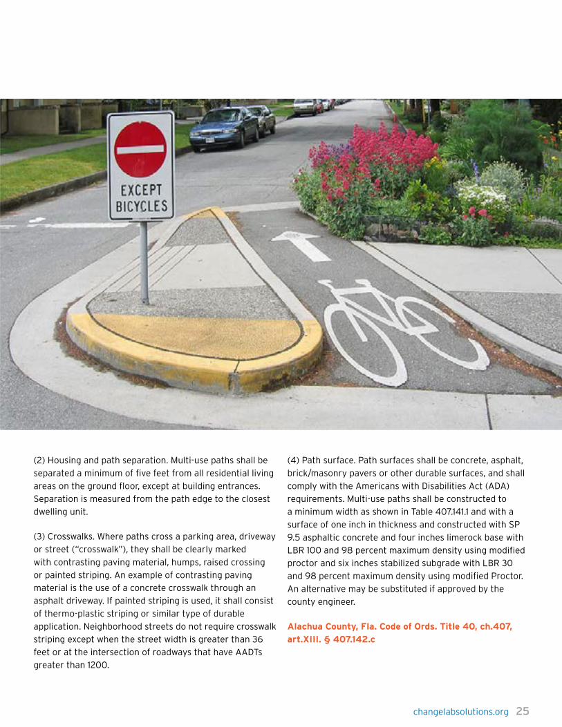
Alachua County, Florida, provides detailed direction on
multi-use paths, making room for creative design solutions
by including guidance on possible locations and required
separations between multi-use paths and homes and
roads. The Land Development Code example selected also
highlights how different materials and elevated treatments
can create distinction between multi-use paths and streets
and driveways.
Conyers, Georgia
Multi-purpose paths. Multi-purpose paths should connect
open space areas with built areas. Any property located
within 1,500 feet of a multi-purpose path shall provide
a direct connection to the path in order to improve
connectivity, promote alternative modes of transportation
and enhance the quality of life. Multi-purpose paths shall
meet the following standards:
a. With the exception of golf carts, the use of motorized
vehicles shall be prohibited.
b. Multi-purpose paths shall require an easement no less
than 30 feet in width.
c. The maximum grade of the multi-purpose path shall be
six percent.
d. Multi-purpose paths shall require a pavement width of
ten feet.
e. Shoulders shall be at least five feet in width and
comprised of grass or mulch.
Conyers, Geo. Code of Ords. Title 8, ch.7, art.C.
§ 8-7-66.i.6
Alachua County, Florida
Multi-use paths. Multi-use paths shall be constructed
parallel to and up to 300 feet from the roadway in an open
space or common area. A multi-use path may satisfy the
pedestrian facility requirement for two parallel roadway
facilities. Multi-use paths are intended to provide safe
and convenient bicycle and pedestrian transportation
to major attractors within a development and between
developments. Multiuse paths can be placed behind
homes or homes can be oriented to front multiuse
paths. Appropriate access management, site distance
and intersection treatments must be used wherever a
multiuse path crosses an intersecting driveway or street.
Development plans shall be designed to provide for safe
pedestrian and bicycle circulation. The county engineer
may require deviations from this requirement due to
public safety concerns. In no instance shall a pedestrian
facility be eliminated entirely from a street corridor. Multi-
use paths shall conform to the following standards.
(1) Vehicle/path separation. Where multi-use paths are
parallel and adjacent to a driveway or street (public or
private), they shall be raised six inches and curbed, or
separated from the driveway or street by a five-foot
minimum strip within bollards, a landscape berm or other
physical barrier. If a raised path is used, the ends of raised
portions shall be equipped with curb ramps.
Bicycle Infrastructure: Separated Trails & Paths
chapTer 4: pedesTrian & Bike-FriendLy code eLeMenTs
changelabsolutions.org 25
(2) Housing and path separation. Multi-use paths shall be
separated a minimum of five feet from all residential living
areas on the ground floor, except at building entrances.
Separation is measured from the path edge to the closest
dwelling unit.
(3) Crosswalks. Where paths cross a parking area, driveway
or street (“crosswalk”), they shall be clearly marked
with contrasting paving material, humps, raised crossing
or painted striping. An example of contrasting paving
material is the use of a concrete crosswalk through an
asphalt driveway. If painted striping is used, it shall consist
of thermo-plastic striping or similar type of durable
application. Neighborhood streets do not require crosswalk
striping except when the street width is greater than 36
feet or at the intersection of roadways that have AADTs
greater than 1200.
(4) Path surface. Path surfaces shall be concrete, asphalt,
brick/masonry pavers or other durable surfaces, and shall
comply with the Americans with Disabilities Act (ADA)
requirements. Multi-use paths shall be constructed to
a minimum width as shown in Table 407.141.1 and with a
surface of one inch in thickness and constructed with SP
9.5 asphaltic concrete and four inches limerock base with
LBR 100 and 98 percent maximum density using modified
proctor and six inches stabilized subgrade with LBR 30
and 98 percent maximum density using modified Proctor.
An alternative may be substituted if approved by the
county engineer.
Alachua County, Fla. Code of Ords. Title 40, ch.407,
art.XIII. § 407.142.c

26 changelabsolutions.org
In addition to bike lanes, signage, or other bicycle
infrastructure, bicycle facilities at workplaces or
commercial areas also promote cycling behavior. Providing
showers and bike storage in office, commercial, and other
public spaces increases the likelihood that cyclists will
undertake more frequent short trips or longer commutes,
particularly in warm or humid climates.
Code ExamplesMontgomery County, Maryland, and San Francisco employ
different strategies for providing bicycle-related facilities.
Montgomery County requires developments with office
uses greater than 100,000 square feet to provide one male
and one female shower or changing facility for employee
use. In addition to requiring short- and long-term bicycle
parking, the City of San Francisco also mandates shower
facilities and lockers for new and existing buildings
undergoing renovations.
Montgomery County, Maryland
(b) For office uses with a total non-residential floor area
of 100,000 square feet of gross floor area or greater, one
shower/change facility is required for each gender; the
facility may be made available only to employees when the
building is accessible.
Montgomery County, MD. Zoning Ordinance. 59-C-15.62(b)
San Francisco, California
(b) Requirements for New Buildings and Buildings With
Major Renovations. New buildings and buildings with
major renovations shall provide shower and clothes locker
facilities for short-term use of the tenants or employees
in that building in accordance with this Section. Where
a building undergoes major renovations, its total square
footage after the renovation is the square footage that
shall be used in calculating how many, if any, showers and
clothes lockers are required.
(c) For new buildings and buildings with major renovations
whose primary use consists of medical or other
professional services, general business offices, financial
services, City government agencies and departments,
general business services, business and trade schools,
colleges and universities, research and development or
manufacturing, the following schedule of required shower
and locker facilities applies:
(1) Where the gross square footage of the floor area exceeds
10,000 square feet but is no greater than 20,000 square
feet, one shower and two clothes lockers are required.
(2) Where the gross square footage of the floor area exceeds
20,000 square feet but is no greater than 50,000 square
feet, two showers and four clothes lockers are required.
(3) Where the gross square footage of the floor area
exceeds 50,000 square feet, four showers and eight
clothes lockers are required.
(d) For new buildings and buildings with major renovations
whose primary use consists of retail, eating and drinking
or personal services, the following table of shower and
locker facilities applies:
(1) Where the gross square footage of the floor area exceeds
25,000 square feet but is no greater than 50,000 square
feet, one shower and two clothes lockers are required.
(2) Where the gross square footage of the floor area exceeds
50,000 square feet but is no greater than 100,000 square
feet, two showers and four clothes lockers are required.
(3) Where the gross square footage of the floor area
exceeds 100,000 square feet, four showers and eight
clothes lockers are required.
San Francisco, Ca., Art. 1.5, § 155.3 (b)(c)(d)
Bicycle Infrastructure: Showers & Lockers
chapTer 4: pedesTrian & Bike-FriendLy code eLeMenTs


28 changelabsolutions.org
Building entrances are often obscured by parking spaces
or, in some instances, parking lots that create dangerous
environments for pedestrians. This type of configuration
increases the likelihood of injury and may discourage
pedestrians from accessing these services.
Code ExamplesBoth Fort Worth, Texas, and Louisville, Kentucky, have
encouraged pedestrian-oriented buildings by ensuring that
building entrances can be accessed directly through the
street. These requirements differ from the current practice
of orienting entrances toward parking lots, often to the
side or rear of a building.
Fort Worth’s code requires that primary entrances face
the street, except where a public space adjoins a building.
Louisville’s code also mandates that the primary entrance
be oriented toward the street or public open space. Where
the primary entrance faces a public space other than
the street, Louisville requires doors and windows on the
side of the building that fronts the primary street. For
a building located on a corner, there must be either an
entrance on both streets or a corner entrance. This same
provision of Louisville’s code also encourages buildings
to create a sense of enclosure by forming a “street wall,”
bringing in another element of pedestrian-friendly design.
Fort Worth, Texas
Primary pedestrian building entrances shall be located on
the street frontage of the building. For buildings fronting
other public spaces, the primary pedestrian entrance shall
be oriented to and accessible from the public space.
Fort Worth, Tex., Near Southside Dev. Standards and
Guidelines § 5.C(3) (2008)
Louisville, Kentucky
Building Location and Orientation
(a.) Principal building entrances shall face the primary
street serving the development or shall be oriented toward
a focal point such as a landscaped public square, plaza or
similar formal public open space. All structures that are
located along the primary street serving the development
shall also have doors or windows facing the primary street
(see b. below for lots with more than one street frontage).
Principal buildings shall be parallel to the primary street.
If the prevalent (more than 50 percent) orientation of
buildings on the block is at an angle to the street, the new
building’s orientation shall be the same as other buildings.
The walls of buildings on corners should be parallel to
the streets.
(b.) Retail and office uses within buildings facing two or
more streets shall have at least one customer entrance
facing the primary street and one customer entrance
facing the second street or instead of two entrances, a
corner entrance.
Louisville, Ky., Land Dev. Code § 5.5.1 (A)(1) (2009)
Building Entries
chapTer 4: pedesTrian & Bike-FriendLy code eLeMenTs

changelabsolutions.org 29
Over the past several decades, buildings have become
wider, and front entrances have been minimized, obscured,
or relocated from the street to the parking lot. Vast,
monolithic buildings present too much dead space, making
pedestrians feel small and out of place. Wide, unadorned
buildings don’t offer as much visual variety as a row of
smaller buildings, and they provide fewer ground-level
services and window displays.
To keep an area visually interesting and define the
spaces on the street, communities can provide for narrow
buildings with many windows or ensure that large, wide
buildings are broken into comfortable units by using
design features (windows, awnings, balconies) that visually
delineate human-scale spaces. In addition, by encouraging
small retail uses on the first floor, pedestrians experience
a wide building as a series of stimulating, appropriately
scaled locations.
Human-scale building design considers both the horizontal
and vertical building scales. When buildings are too
tall, they can create canyon-like streets and block the
sun, which can have an oppressive feel. To prevent
these undesirable effects, communities can require that
buildings taller than three stories should “step back” from
the street before extending upward. Some cities include
“height bonuses” for developers that provide grocery
stores and other forms of retail on the ground level,
offsetting the potential negative aspects of greater height
with the benefits for walkability of ground-floor retail.
Evidence suggests that narrower, taller buildings improve
walkability more than wider, shorter buildings do.
Code ExamplesThe following code examples both focus on incorporating
smaller, human-scale characteristics into large buildings.
San Antonio explicitly emphasizes the need for human
scale, calling for a pattern of windows, doors, and
architectural features that are cohesive and aligned with
adjacent facades. The code requires that commercial and
mixed-use facilities visually distinguish between upper
and lower floors and that ground floors contain a high
percentage of windows. The code also requires that, for
buildings exceeding given lengths (between 30 and 100
feet, depending upon location), street- and riverside
facades be divided into traditionally scaled modules,
giving the appearance of separate buildings.
Salt Lake City does not restrict overall building size
but requires that building facades in developments
exceeding 60,000 square feet have articulated exteriors
and suggests patterns and sheltering roofs. The code
also limits the amount of uninterrupted building length,
although the limitation only applies to buildings in excess
of the already lengthy 300 feet.
San Antonio, Texas
Mass and Scale. A building should appear to have a
“human scale”. In general, this scale can be accomplished
by using familiar forms and elements interpreted in human
dimensions. Exterior wall designs should help pedestrians
establish a sense of scale with relation to each building.
Articulating the number of floors in a building can help to
establish a building’s scale, for example, and prevent larger
buildings from dwarfing the pedestrian.
(1) Express facade components in ways that will help to
establish building scale.
A. Treatment of architectural facades should contain
a discernable (sic) pattern of mass to void, or windows
and doors to solid mass. Openings should appear in a
regular pattern, or be clustered to form a cohesive design.
Architectural elements such as columns, lintels, sills,
canopies, windows and doors should align with other
architectural features on the adjacent facades.
Building Facades
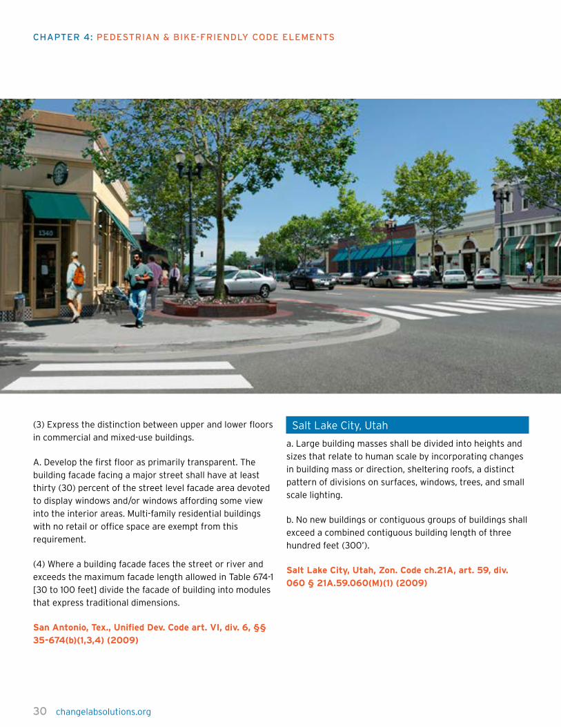
30 changelabsolutions.org
(3) Express the distinction between upper and lower floors
in commercial and mixed-use buildings.
A. Develop the first floor as primarily transparent. The
building facade facing a major street shall have at least
thirty (30) percent of the street level facade area devoted
to display windows and/or windows affording some view
into the interior areas. Multi-family residential buildings
with no retail or office space are exempt from this
requirement.
(4) Where a building facade faces the street or river and
exceeds the maximum facade length allowed in Table 674-1
[30 to 100 feet] divide the facade of building into modules
that express traditional dimensions.
San Antonio, Tex., Unified Dev. Code art. VI, div. 6, §§
35-674(b)(1,3,4) (2009)
Salt Lake City, Utah
a. Large building masses shall be divided into heights and
sizes that relate to human scale by incorporating changes
in building mass or direction, sheltering roofs, a distinct
pattern of divisions on surfaces, windows, trees, and small
scale lighting.
b. No new buildings or contiguous groups of buildings shall
exceed a combined contiguous building length of three
hundred feet (300’).
Salt Lake City, Utah, Zon. Code ch.21A, art. 59, div.
060 § 21A.59.060(M)(1) (2009)
chapTer 4: pedesTrian & Bike-FriendLy code eLeMenTs

changelabsolutions.org 31
Dead SpaceIt is unappealing to walk by the blank, unfriendly expanses
created by windowless structures or by parking lots or
garages. “Dead spaces” like these lack visual interest, often
feel oppressive to pedestrians, and can encourage crime.
Examples of dead spaces include unadorned surface
parking lots (empty or full), long blank walls, vacant lots,
reflective glass facades, featureless open spaces, and
garage doors lined up along the street. Communities can
help curtail dead space by mandating that parking lots
be concealed behind buildings, requiring buildings to
have windows at street level, and encouraging undulating
facades and setbacks.
Code ExamplesSeattle and Fort Worth, Texas, address two different
aspects of preventing dead space in the following code
examples.
Seattle limits parking that is visible from the main street,
creating a set of standards and requirements that differ
depending on the typology of the street. On Class I
pedestrian streets, parking is only allowed in the rear of
buildings or where it is concealed by other uses. On Class
II pedestrian streets, parking is permitted at street level,
but it must be screened from view and 30 percent of the
parking must be separated from the street by other uses,
the facade of which must not present as an imposing blank
wall. The code from Fort Worth focuses on preventing
blank stretches of wall.
Fort Worth requires that, for new buildings, 25 percent or
more of the portion fronting on public streets or spaces
must have transparent windows.
Seattle, Washington
a. On Class I pedestrian streets and designated green
streets, parking is not permitted at street level unless
separated from the street by other uses, provided that
garage doors need not be separated. b. On Class II
pedestrian streets, parking may be permitted at street
level if:
(1) at least thirty (30) percent of the street frontage of
any street level parking area, excluding that portion of the
frontage occupied by garage doors, is separated from the
street by other uses;
(2) the facade of the separating uses satisfies the
transparency and blank wall standards for Class I pedestrian
streets for the zone in which the structure is located;
(3) the portion of the parking, excluding garage doors, that
is not separated from the street by other uses is screened
from view at street level; and
(4) the street facade is enhanced by architectural detailing,
artwork, landscaping, or similar visual interest features.
Seattle, Wash., Mun. Code § 23.49.019(B)(1) (2009)
Fort Worth, Texas
Fenestration (all buildings) – New building facades fronting
on publicly accessible streets or other public spaces
(except alleys) shall have openings and transparent (not
mirrored) glazing that together constitute not less than 25
percent of the facade.
Fort Worth, Tex., Near Southside Dev. Standards and
Guidelines § 5.F(5)(c) (2008)

32 changelabsolutions.org
chapTer 4: pedesTrian & Bike-FriendLy code eLeMenTs
Eyes on the StreetBy encouraging development that leads people to naturally
monitor the streetscape and one another, communities
can enhance safety. Buildings with porches, balconies, and
windows that face streets, parks, and plazas help put more
“eyes on the street.” Communities can also increase this
type of visibility by purposely providing seating on the
street and by encouraging the presence of street vendors
and outdoor dining in areas that need the most surveillance.
When people regularly keep a casual eye on public
spaces, or even when building design makes it clear
that people could be watching, crime goes down and
pedestrians feel safe, not isolated. This can improve
the mental health of a community by lowering stress.
Another strategy for reducing crime is “crime prevention
through environmental design” (CPTED), which can include
landscaping that’s harder for potential criminals to hide
behind, lighting design that reduces blind spots, and
building entries that are more visible to passersby, with
fewer concealed pockets.
Code ExamplesSarasota County, Florida, employs traditional neighborhood
design (TND) principles to ensure high-quality public
spaces where windows and doors open onto tree-lined
streets, plazas, squares, or neighborhood parks. In addition
to the example below (which highlights porches, stoops,
and building visibility from the street), Sarasota County’s
Municipal Code includes comprehensive TND guidance for
mixed-use infill development.
The Seatac, Washington, Municipal Code, on the other
hand, devotes an entire chapter to addressing CPTED
principles. Title 17 includes comprehensive design and
lighting standards for all uses, specifically calling out
uses most often linked to safety issues, such as parking
structures, gasoline stations, and convenience stores. The
example provided highlights the role of urban design and
orientation in providing natural surveillance.

changelabsolutions.org 33
Sarasota County, Florida
5. Front Porches: Front porches may extend up to ten
feet into street yards provided they are at least eight
feet deep. Partial walls, screened areas, and railings on
porches that extend into the street yard may be no higher
than 42 inches. Porches must remain set back at least the
following distances from a public right-of-way:
i.In the Core transect zone, zero feet.
ii.In the General transect zone, two feet.
iii.In the Edge transect zone, five feet.
6. Stoops: Stoops may extend into street yards in the
Core and General transect zones provided their upper
platform is no higher than 42 inches above the sidewalk.
Partial walls and railings on stoops may be no higher
than 42 inches. If requested during the PMI application
process, stoops may extend into the right-of-way to
the extent specifically provided by the Board of County
Commissioners during the PMI approval process, based on
its determination as to the adequacy of sidewalk widths to
allow encroachment by stoops.
8. Windows on Primary Facades: Primary facades on all
Pedestal Building, Lined Building, and Mixed-Use Building
Lots must have between 30 percent and 75 percent of
the primary facade of each story in transparent windows.
For windows to be considered transparent, the window
glass, whether integrally tinted or with applied film, must
transmit at least 50 percent of visible daylight. In addition,
retail stores must comply with the following:
i. The ground story’s primary facade must have
transparent storefront windows covering no less than
75 percent of its principle plane in order to provide clear
views of merchandise in stores and to provide natural
surveillance of exterior street spaces.
ii. Storefronts must remain unshuttered at night to provide
views of display spaces and are encouraged to remain
lit from within until 10:00 p.m. to provide security to
pedestrians.
iii. Doors allowing public access to streets must be
provided at intervals no greater than 75 feet to maximize
street activity, to provide pedestrians with frequent
opportunities to enter buildings, and to minimize any
expanses of inactive wall.
Sarasota County, Fla., Mun. Code § 6.11.5.(e) 5, 6, & 8
Seatac, Washington
B. Natural Surveillance. Natural surveillance is a design
concept directed primarily at keeping intruders under
observation. Provision of natural surveillance helps to
create environments where there is sufficient opportunity
for people engaged in their normal behavior to observe
the space around them. Areas can be designed so they are
more easily observed through:
1. Design and placement of physical features to maximize
visibility. This may include: building orientation, windows,
entrances and exits, parking lots, refuse containers,
walkways, guard gates, landscape trees and shrubs, use of
wrought iron fences or walls, signage and other physical
obstructions.
2. Placement of persons or activities to maximize
surveillance possibilities.
3. Minimum maintained lighting standards that provide for
nighttime illumination of parking lots, walkways, entrances,
exits, and related areas to promote a safe environment.
Seatac, Washington, Title 17 § 17.08.030 (B)

34 changelabsolutions.org
chapTer 4: pedesTrian & Bike-FriendLy code eLeMenTs
Land Use: CommercialSome types of commercial and civic spaces are more
pedestrian-friendly than others. Having stores, parks,
libraries, and restaurants at street level allows people
to run errands on foot and helps create more walkable
and inviting areas. Zoning is an effective strategy for
prohibiting unhealthy or hazardous uses. A community
may want to discourage drive-through restaurants, big
box stores, and auto repair shops in pedestrian- and
bicycle-oriented areas. Pedestrian malls located in civic,
commercial, and retail areas offer prime examples of
commercial uses geared toward pedestrians.
Code ExamplesThese two codes require commercial uses of the type that
support pedestrian activity. Seattle’s takes a streamlined
approach and requires that all lots on designated
pedestrian-oriented streets have at street level a park,
library, or supportive commercial use, such as a store,
restaurant, or entertainment location. San Francisco’s
takes a similar but more detailed approach, explicitly
noting the goal of supporting pedestrian-oriented
commercial uses and laying out in detail the acceptable
uses for street level frontages on given streets. San
Francisco also specifies that such uses shall not include
uses oriented toward motor vehicles.
Seattle, Washington
Street-level uses. One or more of the uses listed in
subsection A are required at street level on all lots
abutting streets designated as Class 1 Pedestrian Streets
shown on Map B, located at the end of this Chapter. A. The
following uses qualify as required street level uses:
1. General sales and service uses;
2. Eating and drinking establishments;
3. Entertainment uses;
4. Public libraries; and
5. Public parks.
Seattle, Wash., Mun. Code § 23.48.019(A) (2009)
San Francisco, California
(a) Purpose: To support active, pedestrian-oriented
commercial uses on important commercial streets.
(c) Definitions. “Active commercial uses” shall include
those uses specifically identified below in Table 145.4
[including amusement game arcade, animal hospital,
automobile sale or rental (with qualifications), bar,
business goods and equipment sales and repair service,
eating and drinking use, entertainment, tourist-oriented
gift store, institutions, jewelry store, neighborhood serving
business, nonauto vehicle sales or rental (see qualification,
above), public use (with qualifications), restaurant, retail
sales and service, financial service, medical service,
personal service, take-out food, trade shop, walk-up
facility], and: (1) Shall not include uses oriented to motor
vehicles except for automobile sale or rental where curb-
cuts, garage doors, or loading access are not utilized or
proposed, and such sales or rental activity is entirely
within an enclosed building and does not encroach on
surrounding sidewalks or open spaces;
San Francisco, Municipal Code, §145.4 (a, c) (1)
changelabsolutions.org 35
Land Use: DensityMedium to high residential and commercial densities
promote walkability and bikeability by ensuring that
a full array of services and destinations are within an
easy walking distance. Although appropriate in some
communities, increased density does not always require
high-rise development. The benefits of density can be
achieved through incremental increases in building
heights, the quantity of residential units, spaces designated
for commercial use, or other suitable metrics of density.
Increased densities can assist in creating safe and vibrant
environments by ensuring that a sufficient number of
people are present at various times of the day. Safer
communities can enjoy higher rates of mental health
due to decreased stress levels, and a dense community
generally emits fewer greenhouse gases per capita, which
can help mitigate climate change.
Requiring higher-density development around transit
centers is appropriate. Concentrating homes and
commercial areas around transit stops helps ensure
sufficient ridership levels to support the transit line, and
diverse commercial uses create interesting and lively
destinations at transit stops.
Cities can promote higher density by requiring a minimum
Floor Area Ratio (FAR), measured by dividing the building
footprint (sum of all floor areas) by the size of the parcel.
Thus, a three-story building that covers 100 percent of the
parcel area would have a FAR of 3.
Code ExamplesBoth of these codes promote higher densities around
transit stations as part of transit-oriented development
policies. In Aurora, Colorado, the zoning code sets a range
of minimum densities that decrease with distance from
the transit station. San Diego requires an average density
rather than a minimum density. Although San Diego’s
average density requirement of 18 units per acre is much
lower than Aurora’s, it appears sufficient to support
transit and provide an active street life. San Diego offers
an incentive for density in the form of a density bonus for
projects planned in the proximity of existing or planned
transit stations.
Aurora, Colorado
1. Principle. Residential densities in TODs [Transit Oriented
Development] are higher than in surrounding areas,
and usually transition from higher densities near the
transit station to lower densities adjacent to surrounding
neighborhoods. Higher densities provide increased
numbers of transit riders within walking distance of rail
stations and provide for lively, interesting places. There
shall be no upper limit for residential densities in the core
sub-area and those densities shall generally exceed 60
units per acres.
2. Required Densities. Residential densities shall be defined
by the station area plan. Where no station area plan has
been adopted, minimum densities shall be as follows:
Core Area: 60 units per acre,
General Area: 40 units per acre,
Transition Area: 20 units per acre.
Aurora, Co., Building and Zoning Code ch. 146, art. 7,
div. 6, § 146-728(C) (2009)
San Diego, California
Density. The combined mixed-use core and residential
components of the urban village shall have an average
density of at least 18 dwelling units per net acre. Maximum
permitted density shall be determined by the base zone
regulations. A 10 percent density bonus over the base zone
density may be permitted for projects located within 2,000
feet of an existing or planned light rail transit station or
other trunk transit line station, unless stated otherwise in
the applicable land use plan.
San Diego, Cal., Mun. Code ch. 13, art. 2, div. 11, §
132.1107(a) (2009)
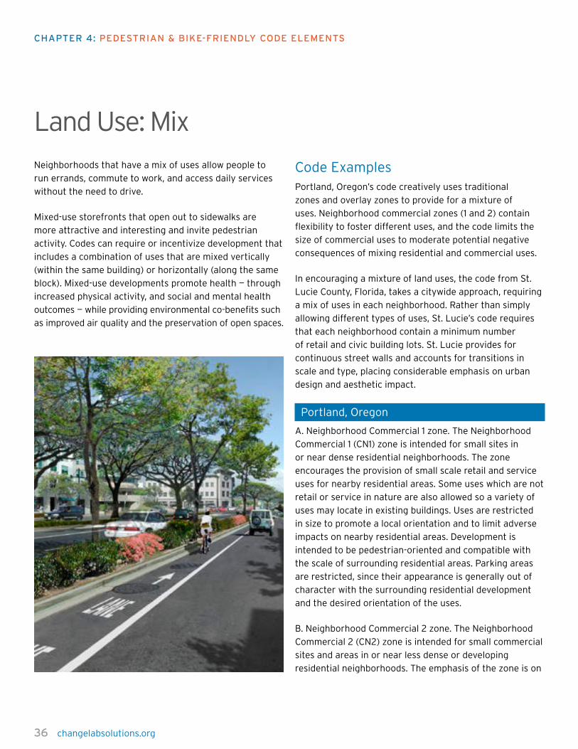
36 changelabsolutions.org
chapTer 4: pedesTrian & Bike-FriendLy code eLeMenTs
Land Use: MixNeighborhoods that have a mix of uses allow people to
run errands, commute to work, and access daily services
without the need to drive.
Mixed-use storefronts that open out to sidewalks are
more attractive and interesting and invite pedestrian
activity. Codes can require or incentivize development that
includes a combination of uses that are mixed vertically
(within the same building) or horizontally (along the same
block). Mixed-use developments promote health — through
increased physical activity, and social and mental health
outcomes — while providing environmental co-benefits such
as improved air quality and the preservation of open spaces.
Code ExamplesPortland, Oregon’s code creatively uses traditional
zones and overlay zones to provide for a mixture of
uses. Neighborhood commercial zones (1 and 2) contain
flexibility to foster different uses, and the code limits the
size of commercial uses to moderate potential negative
consequences of mixing residential and commercial uses.
In encouraging a mixture of land uses, the code from St.
Lucie County, Florida, takes a citywide approach, requiring
a mix of uses in each neighborhood. Rather than simply
allowing different types of uses, St. Lucie’s code requires
that each neighborhood contain a minimum number
of retail and civic building lots. St. Lucie provides for
continuous street walls and accounts for transitions in
scale and type, placing considerable emphasis on urban
design and aesthetic impact.
Portland, Oregon
A. Neighborhood Commercial 1 zone. The Neighborhood
Commercial 1 (CN1) zone is intended for small sites in
or near dense residential neighborhoods. The zone
encourages the provision of small scale retail and service
uses for nearby residential areas. Some uses which are not
retail or service in nature are also allowed so a variety of
uses may locate in existing buildings. Uses are restricted
in size to promote a local orientation and to limit adverse
impacts on nearby residential areas. Development is
intended to be pedestrian-oriented and compatible with
the scale of surrounding residential areas. Parking areas
are restricted, since their appearance is generally out of
character with the surrounding residential development
and the desired orientation of the uses.
B. Neighborhood Commercial 2 zone. The Neighborhood
Commercial 2 (CN2) zone is intended for small commercial
sites and areas in or near less dense or developing
residential neighborhoods. The emphasis of the zone is on

changelabsolutions.org 37
uses which will provide services for the nearby residential
areas, and on other uses which are small scale and have
little impact. Uses are limited in intensity to promote
their local orientation and to limit adverse impacts on
nearby residential areas. Development is expected to be
predominantly auto accommodating, except where the site
is adjacent to a transit street or in a Pedestrian District.
Portland, Or., Zoning Code § 33.130.030(A-B) (2009)
St. Lucie County, Florida
e. Lot Types:
(1) Each neighborhood must contain a mixture of lot types
to provide a variety of uses and diverse housing options
within the neighborhood. Differing lot types may be placed
back-to-back on a single block to provide harmonious
transitions between lot types. Lot types should be selected
to provide buildings of like scale and massing on opposite
sides of streets.
Each neighborhood must contain at least one Mixed-Use
or Retail Building Lot.
Each neighborhood must contain at least three Civic
Building Lots; one civic building must be constructed
within two years after development commences.
St. Lucie County, Fla., Land Dev. Code ch. 3, § 3.01.03.
EE.2.e(1) (2009)
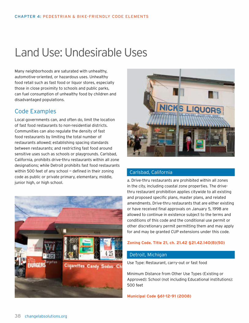
38 changelabsolutions.org
chapTer 4: pedesTrian & Bike-FriendLy code eLeMenTs
Land Use: Undesirable UsesMany neighborhoods are saturated with unhealthy,
automotive-oriented, or hazardous uses. Unhealthy
food retail such as fast food or liquor stores, especially
those in close proximity to schools and public parks,
can fuel consumption of unhealthy food by children and
disadvantaged populations.
Code ExamplesLocal governments can, and often do, limit the location
of fast food restaurants to non-residential districts.
Communities can also regulate the density of fast
food restaurants by limiting the total number of
restaurants allowed; establishing spacing standards
between restaurants; and restricting fast food around
sensitive uses such as schools or playgrounds. Carlsbad,
California, prohibits drive-thru restaurants within all zone
designations; while Detroit prohibits fast food restaurants
within 500 feet of any school — defined in their zoning
code as public or private primary, elementary, middle,
junior high, or high school.
Carlsbad, California
a. Drive-thru restaurants are prohibited within all zones
in the city, including coastal zone properties. The drive-
thru restaurant prohibition applies citywide to all existing
and proposed specific plans, master plans, and related
amendments. Drive-thru restaurants that are either existing
or have received final approvals on January 5, 1998 are
allowed to continue in existence subject to the terms and
conditions of this code and the conditional use permit or
other discretionary permit permitting them and may apply
for and may be granted CUP extensions under this code.
Zoning Code. Title 21, ch. 21.42 §21.42.140(B)(50)
Detroit, Michigan
Use Type: Restaurant, carry-out or fast food
Minimum Distance from Other Use Types (Existing or
Approved): School (not including Educational institutions):
500 feet
Municipal Code §61-12-91 (2008)

changelabsolutions.org 39
LandmarksLandmarks serve as points of reference for pedestrians
and others as they find their way. Landmarks help people
recognize and remember routes, they contribute to the
identity and character of an area, and they can act as
gateways that orient travelers who are approaching or
leaving a district. Landmarks can include monuments,
natural objects, buildings, or other structures that have
notable physical features or historical significance. A
landmark such as a plaza or square can also serve as a
place where people gather or events take place.
Code ExamplesWashington, DC’s code spells out the historic value of
landmarks and calls for their protection and enhancement.
In Aurora, Colorado, the code calls for the dedication of
land for neighborhood parks, community parks, other park
uses, and trails. Park requirements for developments in
urbanized areas, transit-oriented development, or infill
locations can satisfy their parks requirements by providing
accessible and useable public spaces. The code will likely
lead to sites that people identify with a place, and may
create lovely meeting points and reference points for
travel orientation, although these places may not rise to
the order of historic or monumental landmarks.
Washington, District of Columbia
It is hereby declared as a matter of public policy that
the protection, enhancement, and perpetuation of
properties of historical, cultural, and esthetic merit are
in the interests of the health, prosperity, and welfare of
the people of the District of Columbia. Therefore, this
subchapter is intended to:
(1) Effect and accomplish the protection, enhancement,
and perpetuation of improvements and landscape features
of landmark districts which represent distinctive elements
of the city’s cultural, social, economic, political, and
architectural history;
(2) Safeguard the city’s historic, aesthetic and cultural
heritage, as embodied and reflected in such landmarks to
next search terms and districts;
(3) Foster civic pride in the accomplishments of the past;
(4) Protect and enhance the city’s attraction to visitors
and the support and stimulus to the economy thereby
provided; and
(5) Promote the use of landmarks and historic districts for
the education, pleasure, and welfare of the people of the
District of Columbia.
D.C. Code § 6-1101(a) (2009)

40 changelabsolutions.org
chapTer 4: pedesTrian & Bike-FriendLy code eLeMenTs
Aurora, Colorado
(1) Principle. Plazas, main streets, squares or open space
are used to create enduring and memorable public spaces.
These spaces are part of a highly integrated system of
streets, walkways, and buildings that create a sense of
enclosure on the street where citizens walk, recreate,
congregate and interact. These spaces use interesting
entryways and features. Intense uses around these spaces
will activate them and make them lively. The public spaces
are adjacent or well-connected to the transit station.
Outdoor commercial activities, such as outdoor restaurant
seating, will be encouraged as part of the transition
between wholly public outdoor space and wholly private
building space.
(2) Desired Public Spaces. Any public space intended to
satisfy land dedication requirements of section 147-48(b)
of this code shall conform to the criteria set forth in
the Parks and Open Space Dedication and Development
Criteria Manual. Small Urban Park (SUP) is a park
classification that may be used to advance the above
principles of public spaces while concurrently serving park
needs of an urban population in a TOD.
Main streets shall be designed as attractive public areas
with quality streetscaping, provision of space for sidewalk
cafés, and at the appropriate width for the volume of
pedestrians.
Aurora, Co., Building and Zoning Code ch. 146, art. 7,
div. 6, § 146-728(F)(1)(2) (2009)
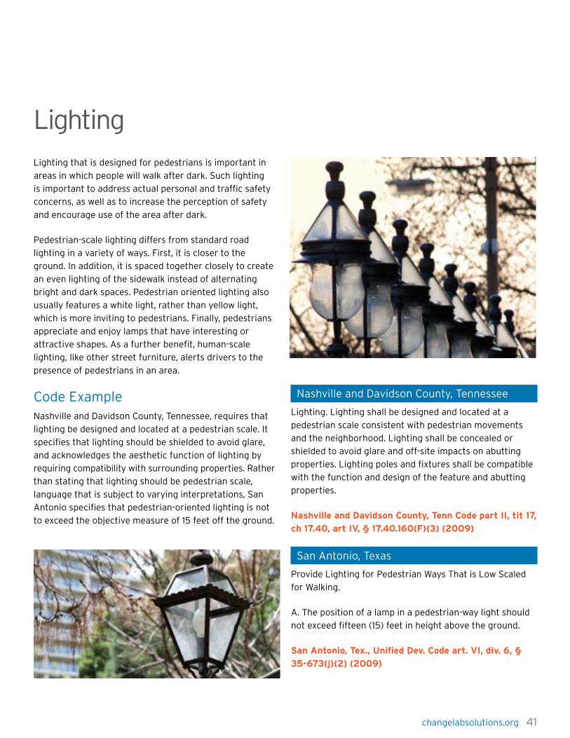
changelabsolutions.org 41
LightingLighting that is designed for pedestrians is important in
areas in which people will walk after dark. Such lighting
is important to address actual personal and traffic safety
concerns, as well as to increase the perception of safety
and encourage use of the area after dark.
Pedestrian-scale lighting differs from standard road
lighting in a variety of ways. First, it is closer to the
ground. In addition, it is spaced together closely to create
an even lighting of the sidewalk instead of alternating
bright and dark spaces. Pedestrian oriented lighting also
usually features a white light, rather than yellow light,
which is more inviting to pedestrians. Finally, pedestrians
appreciate and enjoy lamps that have interesting or
attractive shapes. As a further benefit, human-scale
lighting, like other street furniture, alerts drivers to the
presence of pedestrians in an area.
Code ExampleNashville and Davidson County, Tennessee, requires that
lighting be designed and located at a pedestrian scale. It
specifies that lighting should be shielded to avoid glare,
and acknowledges the aesthetic function of lighting by
requiring compatibility with surrounding properties. Rather
than stating that lighting should be pedestrian scale,
language that is subject to varying interpretations, San
Antonio specifies that pedestrian-oriented lighting is not
to exceed the objective measure of 15 feet off the ground.
Nashville and Davidson County, Tennessee
Lighting. Lighting shall be designed and located at a
pedestrian scale consistent with pedestrian movements
and the neighborhood. Lighting shall be concealed or
shielded to avoid glare and off-site impacts on abutting
properties. Lighting poles and fixtures shall be compatible
with the function and design of the feature and abutting
properties.
Nashville and Davidson County, Tenn Code part II, tit 17,
ch 17.40, art IV, § 17.40.160(F)(3) (2009)
San Antonio, Texas
Provide Lighting for Pedestrian Ways That is Low Scaled
for Walking.
A. The position of a lamp in a pedestrian-way light should
not exceed fifteen (15) feet in height above the ground.
San Antonio, Tex., Unified Dev. Code art. VI, div. 6, §
35-673(j)(2) (2009)
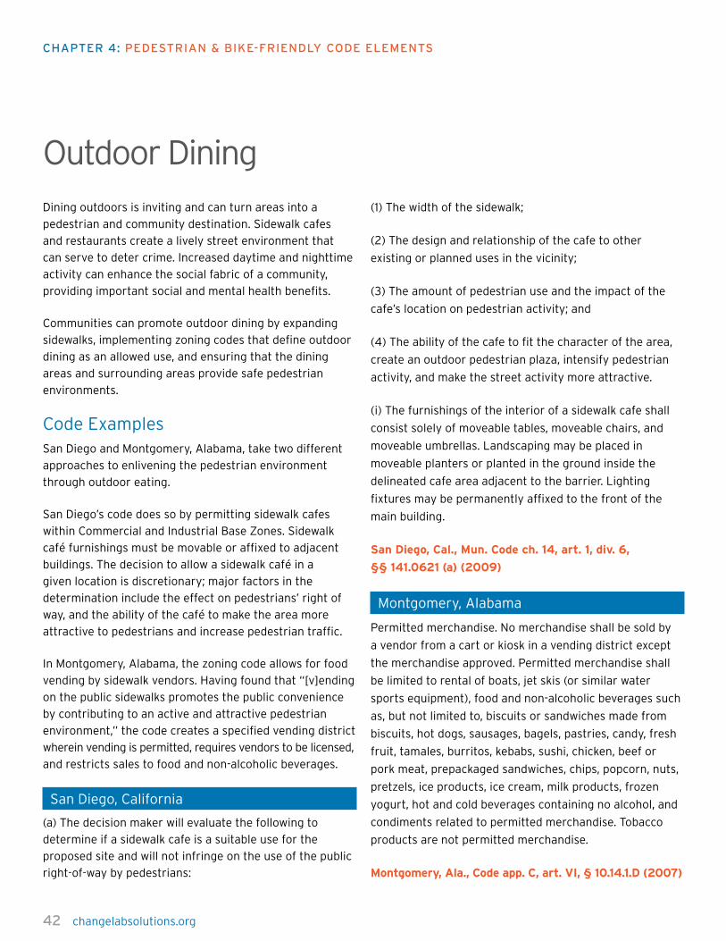
42 changelabsolutions.org
chapTer 4: pedesTrian & Bike-FriendLy code eLeMenTs
Outdoor DiningDining outdoors is inviting and can turn areas into a
pedestrian and community destination. Sidewalk cafes
and restaurants create a lively street environment that
can serve to deter crime. Increased daytime and nighttime
activity can enhance the social fabric of a community,
providing important social and mental health benefits.
Communities can promote outdoor dining by expanding
sidewalks, implementing zoning codes that define outdoor
dining as an allowed use, and ensuring that the dining
areas and surrounding areas provide safe pedestrian
environments.
Code ExamplesSan Diego and Montgomery, Alabama, take two different
approaches to enlivening the pedestrian environment
through outdoor eating.
San Diego’s code does so by permitting sidewalk cafes
within Commercial and Industrial Base Zones. Sidewalk
café furnishings must be movable or affixed to adjacent
buildings. The decision to allow a sidewalk café in a
given location is discretionary; major factors in the
determination include the effect on pedestrians’ right of
way, and the ability of the café to make the area more
attractive to pedestrians and increase pedestrian traffic.
In Montgomery, Alabama, the zoning code allows for food
vending by sidewalk vendors. Having found that “[v]ending
on the public sidewalks promotes the public convenience
by contributing to an active and attractive pedestrian
environment,” the code creates a specified vending district
wherein vending is permitted, requires vendors to be licensed,
and restricts sales to food and non-alcoholic beverages.
San Diego, California
(a) The decision maker will evaluate the following to
determine if a sidewalk cafe is a suitable use for the
proposed site and will not infringe on the use of the public
right-of-way by pedestrians:
(1) The width of the sidewalk;
(2) The design and relationship of the cafe to other
existing or planned uses in the vicinity;
(3) The amount of pedestrian use and the impact of the
cafe’s location on pedestrian activity; and
(4) The ability of the cafe to fit the character of the area,
create an outdoor pedestrian plaza, intensify pedestrian
activity, and make the street activity more attractive.
(i) The furnishings of the interior of a sidewalk cafe shall
consist solely of moveable tables, moveable chairs, and
moveable umbrellas. Landscaping may be placed in
moveable planters or planted in the ground inside the
delineated cafe area adjacent to the barrier. Lighting
fixtures may be permanently affixed to the front of the
main building.
San Diego, Cal., Mun. Code ch. 14, art. 1, div. 6,
§§ 141.0621 (a) (2009)
Montgomery, Alabama
Permitted merchandise. No merchandise shall be sold by
a vendor from a cart or kiosk in a vending district except
the merchandise approved. Permitted merchandise shall
be limited to rental of boats, jet skis (or similar water
sports equipment), food and non-alcoholic beverages such
as, but not limited to, biscuits or sandwiches made from
biscuits, hot dogs, sausages, bagels, pastries, candy, fresh
fruit, tamales, burritos, kebabs, sushi, chicken, beef or
pork meat, prepackaged sandwiches, chips, popcorn, nuts,
pretzels, ice products, ice cream, milk products, frozen
yogurt, hot and cold beverages containing no alcohol, and
condiments related to permitted merchandise. Tobacco
products are not permitted merchandise.
Montgomery, Ala., Code app. C, art. VI, § 10.14.1.D (2007)
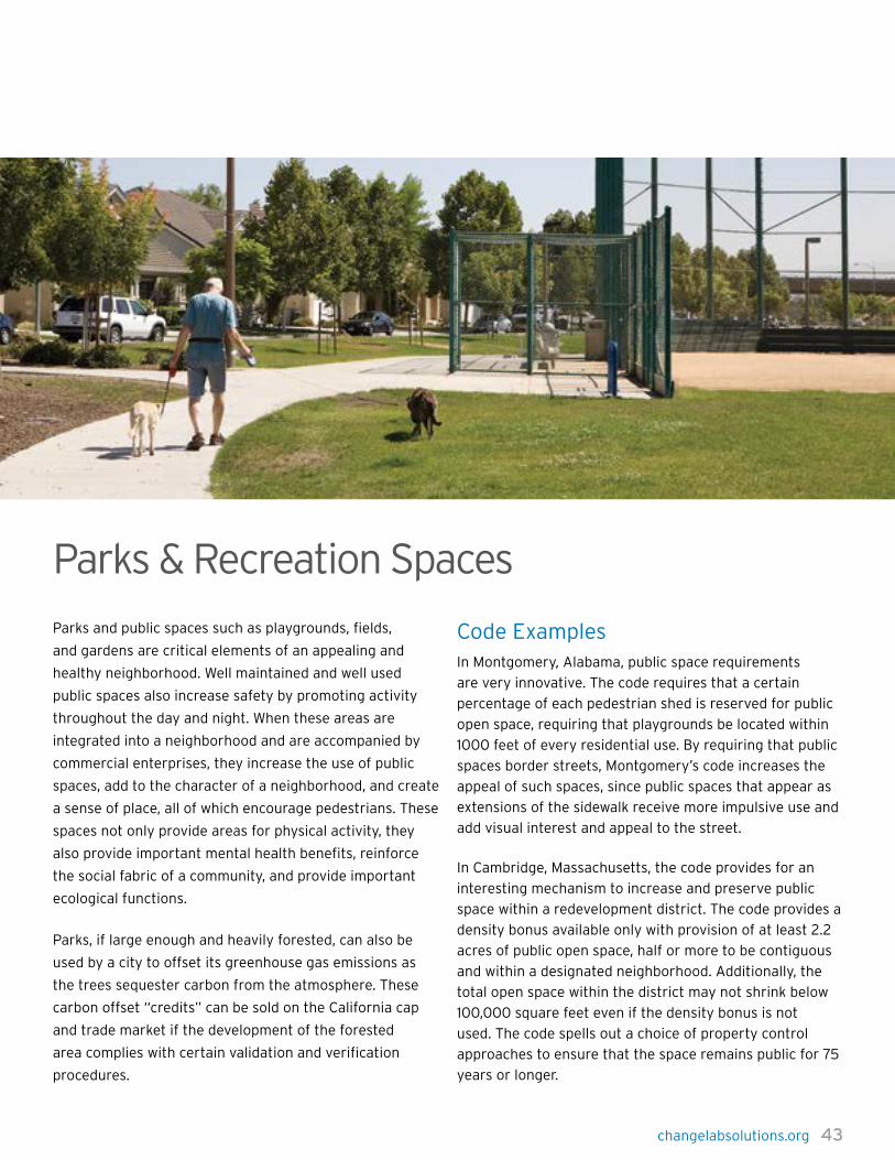
changelabsolutions.org 43
Parks & Recreation Spaces
Parks and public spaces such as playgrounds, fields,
and gardens are critical elements of an appealing and
healthy neighborhood. Well maintained and well used
public spaces also increase safety by promoting activity
throughout the day and night. When these areas are
integrated into a neighborhood and are accompanied by
commercial enterprises, they increase the use of public
spaces, add to the character of a neighborhood, and create
a sense of place, all of which encourage pedestrians. These
spaces not only provide areas for physical activity, they
also provide important mental health benefits, reinforce
the social fabric of a community, and provide important
ecological functions.
Parks, if large enough and heavily forested, can also be
used by a city to offset its greenhouse gas emissions as
the trees sequester carbon from the atmosphere. These
carbon offset “credits” can be sold on the California cap
and trade market if the development of the forested
area complies with certain validation and verification
procedures.
Code ExamplesIn Montgomery, Alabama, public space requirements
are very innovative. The code requires that a certain
percentage of each pedestrian shed is reserved for public
open space, requiring that playgrounds be located within
1000 feet of every residential use. By requiring that public
spaces border streets, Montgomery’s code increases the
appeal of such spaces, since public spaces that appear as
extensions of the sidewalk receive more impulsive use and
add visual interest and appeal to the street.
In Cambridge, Massachusetts, the code provides for an
interesting mechanism to increase and preserve public
space within a redevelopment district. The code provides a
density bonus available only with provision of at least 2.2
acres of public open space, half or more to be contiguous
and within a designated neighborhood. Additionally, the
total open space within the district may not shrink below
100,000 square feet even if the density bonus is not
used. The code spells out a choice of property control
approaches to ensure that the space remains public for 75
years or longer.

44 changelabsolutions.org
chapTer 4: pedesTrian & Bike-FriendLy code eLeMenTs
Montgomery, Alabama
(a.) Each Pedestrian Shed shall assign at least 5 percent of
its urbanized area to Civic Space…
(c.) Each Pedestrian Shed shall contain at least one main
Civic Space. The main Civic Space shall be within 800 feet
of the geographic center of each Pedestrian Shed, unless
topographic conditions, existing Thoroughfare alignments,
or other circumstances require otherwise.
(d.) Within 1000 feet of every lot in residential use, a Civic
Space designed and equipped as a playground shall be
provided.
(e.) Each Civic Space shall have a minimum of 50 percent
of its perimeter enfronting a Thoroughfare.
Montgomery, Ala., Zon. Code app. C, art. VI,
§ 10.14.2(2.7.2)(a.-e.) (2007)
Cambridge, Massachusetts
15.41 Public Open Space Requirement.
As an incentive for the maximum allowable density as
provided in Subsection 15.32.1 there is a requirement that
a minimum amount of one hundred thousand (100,000)
square feet within the District be permanently reserved
or designated (without reference to location) as publicly
beneficial open space accessible at ground level as set
forth in Section 15.32.5. No development shall be allowed
which would permanently reduce publicly beneficial open
space in the District below one hundred thousand (100,000)
square feet. A minimum of fifty thousand (50,000) square
feet of contiguous publicly beneficial open space shall
be located west of Sidney Street. The initial location
of the required publicly beneficial open space shall be
guaranteed through one or more of the following.
Cambridge, Mass., Zoning Ord. § 15.41 (2009)
(Mun. Code § 17.04.010)
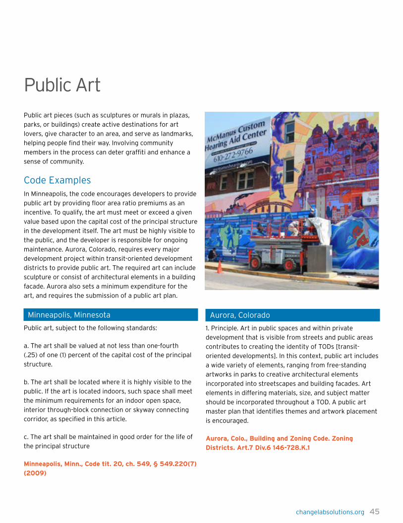
changelabsolutions.org 45
Public ArtPublic art pieces (such as sculptures or murals in plazas,
parks, or buildings) create active destinations for art
lovers, give character to an area, and serve as landmarks,
helping people find their way. Involving community
members in the process can deter graffiti and enhance a
sense of community.
Code ExamplesIn Minneapolis, the code encourages developers to provide
public art by providing floor area ratio premiums as an
incentive. To qualify, the art must meet or exceed a given
value based upon the capital cost of the principal structure
in the development itself. The art must be highly visible to
the public, and the developer is responsible for ongoing
maintenance. Aurora, Colorado, requires every major
development project within transit-oriented development
districts to provide public art. The required art can include
sculpture or consist of architectural elements in a building
facade. Aurora also sets a minimum expenditure for the
art, and requires the submission of a public art plan.
Minneapolis, Minnesota
Public art, subject to the following standards:
a. The art shall be valued at not less than one-fourth
(.25) of one (1) percent of the capital cost of the principal
structure.
b. The art shall be located where it is highly visible to the
public. If the art is located indoors, such space shall meet
the minimum requirements for an indoor open space,
interior through-block connection or skyway connecting
corridor, as specified in this article.
c. The art shall be maintained in good order for the life of
the principal structure
Minneapolis, Minn., Code tit. 20, ch. 549, § 549.220(7)
(2009)
Aurora, Colorado
1. Principle. Art in public spaces and within private
development that is visible from streets and public areas
contributes to creating the identity of TODs [transit-
oriented developments]. In this context, public art includes
a wide variety of elements, ranging from free-standing
artworks in parks to creative architectural elements
incorporated into streetscapes and building facades. Art
elements in differing materials, size, and subject matter
should be incorporated throughout a TOD. A public art
master plan that identifies themes and artwork placement
is encouraged.
Aurora, Colo., Building and Zoning Code. Zoning
Districts. Art.7 Div.6 146-728.K.1
46 changelabsolutions.org
chapTer 4: pedesTrian & Bike-FriendLy code eLeMenTs
Public SpacesThe following codes creatively use the development
process to increase the number and quality of public
plazas and waiting spaces.
Code ExamplesPortland, Oregon, innovatively allows the substitution of
transit plazas for up to 10 percent of parking that would
otherwise be required, encouraging attractive transit stops
with more public space. Such transit plazas must be at
least 300 square feet in size and open to the public. The
plazas must include seating, shelter, and landscaping. The
code does not only apply to new development, but also
allows existing parking to be converted to transit plazas.
Salt Lake City’s takes a different approach, requiring
developers to provide public space in proportion to the
total floor area of the development (1 square foot of
public spaces for every 10 square feet of building area).
The code allows a choice of elements for the public space
that will “activate” the space, including seating, trees,
water features, and eating areas. Because use of outdoor
space increases when there is a mixture of sun and shade,
the option to include shade and trees increases the
attractiveness of the space.
Portland, Oregon
Substitution of transit-supportive plazas for required
parking. Sites where at least 20 parking spaces are
required, and where at least one street lot line abuts a
transit street may substitute transit-supportive plazas for
required parking, as follows. Existing parking areas may be
converted to take advantage of these provisions…
d. The plaza must include all of the following elements:
(1) A plaza open to the public. The owner must record a
public access easement that allows public access to the
plaza;
(2) A bench or other sitting area with at least 5 linear feet
of seating;
(3) A shelter or other weather protection. The shelter must
cover at least 20 square feet. If the plaza is adjacent to the
bus stop, TriMet must approve the shelter; and
(4) Landscaping. At least 10 percent, but not more than 25
percent of the transit-supportive plaza must be landscaped
to the L1 standard of Chapter 33.248, Landscaping and
Screening. This landscaping is in addition to any other
landscaping or screening required for parking areas by the
Zoning Code.
Portland, Or., Zon. Code ch. 33, art. 266, div 14,
§ 33.266.110(B)(5)(d)(2009)
Salt Lake City, Utah
b. Plazas or public spaces shall incorporate at least three
(3) of the five (5) following elements:
(1) Sitting space of at least one sitting space for each two
hundred fifty (250) square feet shall be included in the
plaza. Seating shall be a minimum of sixteen inches (16\”)
in height and thirty inches (30\”) in width. Ledge benches
shall have a minimum depth of thirty inches (30\”);
(2) A mixture of areas that provide shade;
(3) Trees in proportion to the space at a minimum of one
tree per eight hundred (800) square feet, at least two inch
(2\”) caliper when planted;
(4) Water features or public art; and/or
(5) Outdoor eating areas or food vendors.
Salt Lake City, Ut., Zon. Code ch.21A, art. 59, div. 060,
§ 21A.59.060(M)(2)(b) (2009)

48 changelabsolutions.org
chapTer 4: pedesTrian & Bike-FriendLy code eLeMenTs
In many communities, sidewalks start and stop without
warning or are lacking altogether, endangering
pedestrians. In addition, narrow sidewalks can force
pedestrians to walk into the street to get around obstacles
and other people.
Sidewalks should be wide enough to accommodate a
landscaped “planting strip,” which serves as a barrier from
traffic and a place to plant trees for shade and beauty.
Ideally, sidewalks should also be wide enough to allow
benches for older adults and families to stop and rest or
relax. Generally, two couples or two wheelchairs should be
able to pass each other comfortably on a sidewalk, which
requires about 10 to 12 feet across.
Wide sidewalks can also provide room for outdoor dining,
public art, and other community-oriented activities.
Code ExamplesSeattle requires a minimum 12 foot sidewalk, wide enough
for considerable pedestrian traffic and for couples to pass
one another.
Seattle, Washington
1. The owner shall construct a sidewalk no less than twelve
(12) feet in width.
2. The owner shall plant street trees adjacent to the major
pedestrian street. The trees shall meet criteria prescribed
by the Director of Transportation.
3. Planting strips are prohibited along major pedestrian
streets.
4. The owner shall install street furniture and planting boxes
adjacent to the major pedestrian street. The installation
shall conform to the Right-of-Way Improvements Manual.
Seattle, Wash., Mun. Code tit. 23, subtit. 3, div. 3, ch.
23.71, § 23.71.008(E)(2009)
Columbus, Ohio
All subdivisions, site developments or sections thereof
which, shall have installed in them sidewalks and bikeway
facilities as specified in the Bicentennial Bikeways Plan
to serve each lot or parcel therein. Such sidewalks and
bikeway facilities shall be installed by the property owners
abutting the street rights-of-way within the development
and along the existing streets fronting the development:
(A) Sidewalks and bikeways shall have a hard, improved
surface constructed of materials and to standards
established by the director of public service and/or their
designee depending on type of street construction,
anticipated permanence of sidewalk, and land uses
being served. Such specifications shall be available for
inspection in the department of public service offices.
(B) Sidewalks and bikeways shall be located in the right-
of-way of the street or as close to the right-of-way line as
possible, and shall extend across the entire dimension of
each lot or parcel side adjacent to a public street.
(D) Bikeways shall be located, configured and completed
according to the Bicentennial Bikeways Plan and include
separate shared-use paths, bike lanes and signed and
marked shared bike routes.
(G) Sidewalk or Bikeway Fee in Lieu of Construction. It
is the desire of the city to have required sidewalks and
bike facilities built at the time of and congruent with
development. However, there may be circumstances
regarding safety, economic waste and geographical
features that preclude such construction. The Director of
Public Service has the authority to approve construction
exemptions and collect a fee in lieu of as set out in
properly promulgated rules and regulations. In no instance
will a private or public entity not build or pay a fee in lieu
of sidewalk or bike facility construction.
Columbus, OH. Regulations for Land Development.
§ 4307.29
Sidewalks
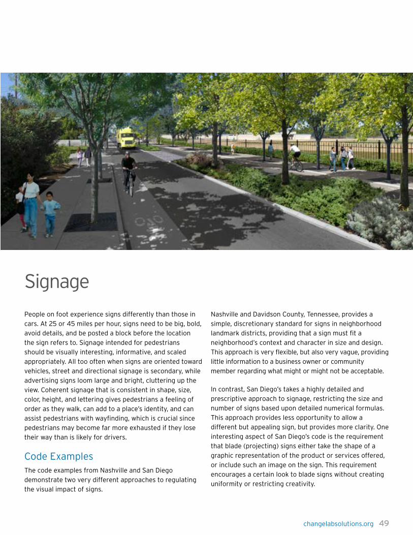
changelabsolutions.org 49
People on foot experience signs differently than those in
cars. At 25 or 45 miles per hour, signs need to be big, bold,
avoid details, and be posted a block before the location
the sign refers to. Signage intended for pedestrians
should be visually interesting, informative, and scaled
appropriately. All too often when signs are oriented toward
vehicles, street and directional signage is secondary, while
advertising signs loom large and bright, cluttering up the
view. Coherent signage that is consistent in shape, size,
color, height, and lettering gives pedestrians a feeling of
order as they walk, can add to a place’s identity, and can
assist pedestrians with wayfinding, which is crucial since
pedestrians may become far more exhausted if they lose
their way than is likely for drivers.
Code ExamplesThe code examples from Nashville and San Diego
demonstrate two very different approaches to regulating
the visual impact of signs.
Nashville and Davidson County, Tennessee, provides a
simple, discretionary standard for signs in neighborhood
landmark districts, providing that a sign must fit a
neighborhood’s context and character in size and design.
This approach is very flexible, but also very vague, providing
little information to a business owner or community
member regarding what might or might not be acceptable.
In contrast, San Diego’s takes a highly detailed and
prescriptive approach to signage, restricting the size and
number of signs based upon detailed numerical formulas.
This approach provides less opportunity to allow a
different but appealing sign, but provides more clarity. One
interesting aspect of San Diego’s code is the requirement
that blade (projecting) signs either take the shape of a
graphic representation of the product or services offered,
or include such an image on the sign. This requirement
encourages a certain look to blade signs without creating
uniformity or restricting creativity.
Signage
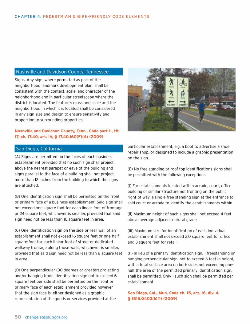
50 changelabsolutions.org
chapTer 4: pedesTrian & Bike-FriendLy code eLeMenTs
Nashville and Davidson County, Tennessee
Signs. Any sign, where permitted as part of the
neighborhood landmark development plan, shall be
consistent with the context, scale, and character of the
neighborhood and in particular streetscape where the
district is located. The feature’s mass and scale and the
neighborhood in which it is located shall be considered
in any sign size and design to ensure sensitivity and
proportion to surrounding properties.
Nashville and Davidson County, Tenn., Code part II, tit.
17, ch. 17.40, art. IV, § 17.40.160(F)(4) (2009)
San Diego, California
(A) Signs are permitted on the faces of each business
establishment provided that no such sign shall project
above the nearest parapet or eave of the building and
signs parallel to the face of a building shall not project
more than 12 inches from the building to which the signs
are attached.
(B) One identification sign shall be permitted on the front
or primary face of a business establishment. Said sign shall
not exceed one square foot for each linear foot of frontage
or 24 square feet, whichever is smaller, provided that said
sign need not be less than 10 square feet in area.
(C) One identification sign on the side or rear wall of an
establishment shall not exceed 16 square feet or one-half-
square-foot for each linear foot of street or dedicated
walkway frontage along those walls, whichever is smaller,
provided that said sign need not be less than 8 square feet
in area.
(D) One perpendicular (30 degrees or greater) projecting
and/or hanging trade identification sign not to exceed 6
square feet per side shall be permitted on the front or
primary face of each establishment provided however
that the sign face is, either designed as a graphic
representation of the goods or services provided at the
particular establishment, e.g. a boot to advertise a shoe
repair shop, or designed to include a graphic presentation
on the sign.
(E) No free standing or roof top identifications signs shall
be permitted with the following exceptions:
(i) For establishments located within arcade, court, office
building or similar structure not fronting on the public
right-of-way, a single free standing sign at the entrance to
said court or arcade to identify the establishments within.
(ii) Maximum height of such signs shall not exceed 4 feet
above average adjacent natural grade.
(iii) Maximum size for identification of each individual
establishment shall not exceed 2.0 square feet for office
and 3 square feet for retail.
(F) In lieu of a primary identification sign, 1 freestanding or
hanging perpendicular sign, not to exceed 6 feet in height,
with a total surface area on both sides not exceeding one-
half the area of the permitted primary identification sign,
shall be permitted. Only 1 such sign shall be permitted per
establishment
San Diego, Cal., Mun. Code ch. 15, art. 16, div. 4,
§ 1516.0403(b)(1) (2009)

changelabsolutions.org 51
Public benches and seating where pedestrians can take
a rest, meet a friend, or wait for transit are important
for pedestrian-oriented areas. Older adults, pedestrians
with disabilities, and families may need to stop and rest
frequently. Street furniture (such as benches, drinking
fountains, and trash cans) is often regarded as an optional
amenity, but can contribute markedly to the comfort and
character of an area for pedestrians. Seating areas should
include amenities such as shade trees, shelter, attractive
lighting, and informational signage. By making these
spaces visible from surrounding areas, safety is improved
for both those seated and pedestrians within the vicinity.
To avoid visual clutter and pedestrian obstruction, street
furniture should be grouped at particular intervals along
the street so that the clusters of furniture can function
as pedestrian rest stops and potential gathering areas
without impeding pedestrian movement.
Code ExamplesSan Antonio’s code features a number of excellent
provisions regarding street furniture. The code calls for
a variety of different seating options, supports physical
activity by encouraging drinking fountains, and calls for
inconspicuous but convenient trash cans. Recognizing
the important aesthetic and place-making role of street
furniture, the code notes that street furniture should not be
uniform, but should complement the distinctive nature of
the district in which it is located. San Antonio also requires
a clear path without obstacles for walking, and suggests
clustering different types of street furniture to increase use,
create friendly gathering spots, and avoid clutter.
San Diego’s includes street furniture code language that
focuses on benches and their appearance, requiring
that benches be wood or iron, rather than plastic, and
prohibiting advertisements on benches located in the right
of way. The code also requires that street furniture not
intrude into the wide sidewalk, and regulates the positioning
of benches to allow socializing and people-watching.
San Antonio, Texas
Historic districts and the downtown, as well as other
distinct areas of the city have diverse character and
any street furniture selected for these areas should
complement these differences. In addition, the clustering
of street furniture in one (1) place is recommended. Trash
receptacles, seating, telephones and other street furniture
should be grouped together.
A. Circulation.
A clear path-of-travel of thirty-six (36) inches wide
shall be maintained in and around street features and
arrangement.
B. Seating.
Seating should be physically comfortable and inviting,
durable and attractive. Plaza and open space seating
should also be socially comfortable by offering a variety
of choices such as in the sun or shade, near traffic and
activity or not, and alone or in groups.
C. Drinking Fountains.
Placing drinking fountains in new development is
encouraged. Fountains should be placed within general
areas of pedestrian traffic and located on accessible
surfaces.
D. Trash Receptacles.
Trash receptacles should blend visually with their
surroundings and their design and location should make
use as convenient as possible.
San Antonio, Tex., Unified Dev. Code art. VI, div. 4,
§§ 35-646(a)(3)(A)–(D) (2009)
Street Furniture
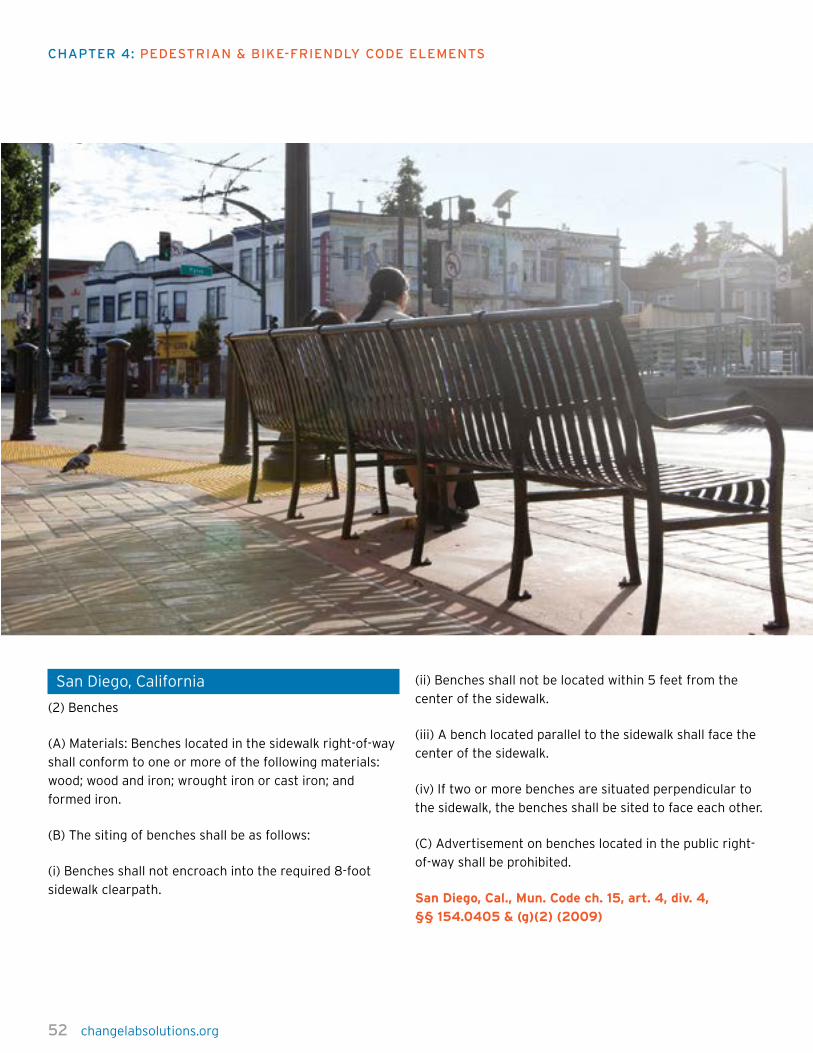
52 changelabsolutions.org
chapTer 4: pedesTrian & Bike-FriendLy code eLeMenTs
San Diego, California
(2) Benches
(A) Materials: Benches located in the sidewalk right-of-way
shall conform to one or more of the following materials:
wood; wood and iron; wrought iron or cast iron; and
formed iron.
(B) The siting of benches shall be as follows:
(i) Benches shall not encroach into the required 8-foot
sidewalk clearpath.
(ii) Benches shall not be located within 5 feet from the
center of the sidewalk.
(iii) A bench located parallel to the sidewalk shall face the
center of the sidewalk.
(iv) If two or more benches are situated perpendicular to
the sidewalk, the benches shall be sited to face each other.
(C) Advertisement on benches located in the public right-
of-way shall be prohibited.
San Diego, Cal., Mun. Code ch. 15, art. 4, div. 4,
§§ 154.0405 & (g)(2) (2009)

changelabsolutions.org 53
A street wall consists of a continuous set of building
facades with similar heights that are set back a similar
distance from the property line. For pedestrians, having a
street wall on both sides of the street creates a feeling of
comfort and enclosure. Buildings should not stand too far
apart from each other, and driveways should be kept to a
minimum, not only to preserve the continuity of the street
wall, but also so that pedestrians do not have to dodge
cars turning into or out of driveways.
Minor setback variations, however, can keep the street
wall from feeling monotonous. Although street walls help
create a pedestrian-friendly street, many vibrant urban
areas have other types of building arrangements, so this
element is not necessary everywhere.
Code ExamplesSeattle’s requires that on designated pedestrian-oriented
streets, each building facade must be built to the street
property line for 70 percent of the building. Peoria’s
code is similar, but provides more detailed specifications.
Peoria, Illinois, has the more demanding requirement that
80 percent of the facade be built to the required building
line, but provides flexibility by allowing jogs of 18 inches to
accommodate architectural details such as bay windows,
shop fronts, and the like. The required building line
frequently is the same as the street property line, but need
not be. Peoria also ensures that the street wall prevails at
street corners by requiring that the facade be built out to
the required building line within 30 feet of a corner.
Seattle, Washington
All facades on Class 1 Pedestrian Streets, as shown on
Map B, shall be built to the street property line along a
minimum of seventy (70) percent of the facade length.
Seattle, Wash., Mun. Code tit. 23, subtit. 3, div. 2, ch.
23.48, § 23.48.014 (C) (2009)
Peoria, Illinois
Street Facade
a. On each lot the building facade shall be built to the
required building line for at least 80 percent of the
required building line length.
b. The building facade shall be built to the required
building line (RBL) within 30 feet of a block corner.
c. These portions of the building facade (the required
minimum build-to) may include jogs of not more than 18
inches in depth except as otherwise provided to allow bay
windows, shopfront, and balconies.
Peoria, Ill., Code app. C, § 6.2(A)(9) (2009)
Street Walls
54 changelabsolutions.org
chapTer 4: pedesTrian & Bike-FriendLy code eLeMenTs
Streets: ConnectivityAn interconnected street network is crucial for
pedestrians. Shorter blocks with frequent crossings
provide quick connections so pedestrians can get directly
to their destinations.
The traditional grid street network brings a variety of
benefits to pedestrians — direct routes, parallel streets
that provide interesting alternate routes, clear orientation
so that pedestrians do not get lost easily, and an orderly
progression of streets. However, the repetitive form of the
traditional grid network can become boring.
Variations on the grid network can increase pedestrian
activity in an area by providing visual interest. For
example, some communities have oriented their streets
to frame attractive vistas, which can help with pedestrian
orientation. A modified grid, with T intersections, appears
to reduce the number and severity of vehicle collisions,
increasing pedestrians’ safety. While different forms of the
grid work well under different circumstances, connectivity
is the constant.
Code ExamplesSt. Lucie County, Florida, provides for an interconnected
network, but puts less emphasis on a grid per se, allowing
streets to be curved or bent, as long as they connect
to other streets. St. Lucie County emphasizes short
routes and connectivity between attractive pedestrian
destinations such as schools, parks, and retail, and limits
to use of culs-de-sac. Interestingly, both San Diego and St.
Lucie call for alleys as one method of balancing vehicle
and pedestrian needs.
San Diego’s calls for a grid pattern explicitly. It also allows
a modified grid, providing flexibility that may enable it to
maximize the benefits of a grid while avoiding some of the
drawbacks, particularly in places where topography makes
a grid less practical. The code provides for short blocks,
and recognizes pedestrians’ desire to reach destinations
without crossing busy streets. The code also calls for
streets to frame vistas to enhance visual interest and
orientation for pedestrians.
St. Lucie County, Florida
Each neighborhood must provide an interconnected
network of streets, alleys or lanes, and other public
passageways.
(i.) Neighborhood streets must be designed to encourage
pedestrian and bicycle travel by providing short routes to
connect residential uses with nearby commercial services,
schools, parks, and other neighborhood facilities within
the same or adjoining Towns or Villages. Sidewalks and
rows of street trees must be provided on both sides of all
neighborhood streets…
(iii.) Neighborhood streets do not have to form an
orthogonal grid and are not required to intersect at ninety-
degree angles. These streets may be curved or bent but
must connect to other streets…
(vii.) A continuous network of rear and side alleys and/
or lanes is desirable to serve as the primary means of
vehicular ingress to individual lots…
viii. Cul-de-sacs are not permitted except where physical
conditions such as freeways provide no practical
alternatives for connection for through traffic.
ix. Street stubs must be provided to adjacent undeveloped
land to ensure an integrated street network is achieved
over time.
St. Lucie County, Fla., Land Dev. Code ch. 3, § 3.01.03.
EE.2.k(2) (2009)

changelabsolutions.org 55
San Diego, California
Street Pattern. The layout of the street system shall be
in a grid pattern or modified grid pattern, emphasizing
interconnected streets and the ability to reach local
destinations without crossing major streets or primary
arterials. It is desirable to have streets with block faces of
400 feet in length or less. The use of alleys is encouraged.
Where possible, streets should frame vistas of the mixed-
use core, public buildings, parks, and natural features.
San Diego, Cal., Mun. Code § 132.1109(a) (2009)

56 changelabsolutions.org
chapTer 4: pedesTrian & Bike-FriendLy code eLeMenTs
Streets: Block LengthLong street blocks are inconvenient and unsafe for
pedestrians. Long blocks commonly have crosswalks only
at intersections, imprisoning cautious pedestrians on
one side of the street and indirectly encouraging unsafe
mid-street crossings as the only practical means to access
places directly across the street.
Long blocks also encourage higher vehicle speeds due to
fewer traffic calming mechanisms than shorter blocks,
with more frequent intersections, provide. Vehicles are
less likely to anticipate pedestrians on the road, leading to
more collisions, and vehicle-pedestrian collisions at higher
vehicle speeds are more serious and lethal. Long blocks
also require pedestrians to go out of their way to get to
locations that are on the next block over.
Shorter blocks and more crossings provide flexibility and
options for pedestrians. Mid-block street crossings and
pedestrian walkways through the middle of large blocks or
buildings also help address these problems, but mid-block
pedestrian crossings must be designed to be safe and
clearly apparent to vehicle operators. These approaches
make walking more direct and convenient by offering more
opportunities for pedestrians to safely access destinations
around their community.
Code ExamplesMadison, Wisconsin, takes a very simple approach to
restricting block length, providing a general limitation of
500 feet and permitting limited exceptions. The exception
for topography provides flexibility in recognition of local
conditions. By requiring approval for exceptions, the
code provides some safeguard against overuse of the
exceptions process.
Albuquerque, New Mexico, adopts an approach that is
slightly more complex. Albuquerque’s code requires
considerably smaller blocks, limiting block size to 400 feet
and requiring that blocks over 300 feet provide mid-block
pedestrian access. Albuquerque also provides for some
flexibility in recognition of existing conditions, but includes
provisions requiring that mid-block access points be
provided during redevelopment in areas where block size
exceeds 400 feet.
Madison, Wisconsin
Block Size. Block perimeter for new development shall
not exceed a maximum of 1600 feet. No block shall
exceed 400 feet in length measured from center of
R.O.W. [Right of Way]. Block lengths longer than 300 feet
shall be provided with mid-block access points. If a block
size in a developed area exceeds these standards, mid-
block pedestrian access points shall be included in any
redevelopment projects such that block lengths do not
exceed 400 feet. The Planning Director may modify block
size standards based on limitations of existing conditions.
Madison, Wis., Code § 28.08(13)(i) (2009), subsequently
revised by Madison, Wis., Code Ch 28 (adopted 2011)
Albuquerque, New Mexico
In the R2S District, block lengths shall not, as a general
rule, exceed 500 feet in length between street lines, unless
required by exceptional topography or other limiting
factors when approved by the Plan Commission.
Albuquerque, N.M., Code § 14-16-3-22(B)(1)(i)(1) (2009)

changelabsolutions.org 57
Streets: Road WidthsWide streets with many lanes of traffic are common, but
they are difficult and dangerous for pedestrians to cross or
cyclists to navigate. Multiple lanes of fast-moving cars can
be dangerous and often feel threatening to pedestrians
walking along a thoroughfare.
Encouraging narrower roads is one of the best ways to
increase safety and comfort for pedestrians and cyclists.
Where appropriate, communities can make large, wide
roads safer and more attractive by expanding sidewalks
and adding landscaped “planting strips” that buffer the
sidewalk from the street. Other helpful additions include
bicycle lanes, bulbouts, and landscaped medians. Bulbouts
extend the sidewalk into the intersection, shortening the
crossing distance for pedestrians, while medians provide
a safe waiting place for pedestrians who are not able to
cross all lanes at once.
With fewer lanes and the addition of pedestrian and
cycling infrastructure, drivers not only drive at safer
speeds, but they also become more aware that the road
is a shared space. But if narrowing existing roadways,
expanding sidewalks, and installing medians is not
feasible, communities can achieve some benefits through
traffic-calming mechanisms, speed limit enforcement,
and appropriate signage and pedestrian crossings along
roadways.
Code ExamplesAlthough streets that are wider than two to four lanes
pose considerable challenges for pedestrians, it is the rare
community today that is able to do away entirely with
the demand for such streets. The following provisions
demonstrate two attempts to address this issue.
Oregon’s administrative rule 660-012-0045(7) instructs
local governments to establish standards to minimize
excessive width requirements for streets, to reduce
design speed and provide for the needs of pedestrians
and bicyclists. The rule also balances emergency
vehicle requirements, a common source of concern for
jurisdictions considering narrower streets. The rule is
worded generally and could apply to both the width and
number of lanes.
Albuquerque, New Mexico, provides for the boulevard as
the widest permissible street type, and the code provides a
number of restrictions and controls to make these streets
somewhat safer and more welcoming for pedestrians.
By providing for one-way slip roads separated from the
primary three or four lanes, the boulevard ensures that
pedestrians walking along the right of way experience
slower traffic and are buffered from the rapidly-moving
bulk of vehicular traffic. Additionally, the landscaped
medians that separate the slip from traffic provide
some refuge for pedestrians who are crossing, ensuring
that they need not make their way across so broad and
inhospitable an expanse of roadway.
Oregon State
Local governments shall establish standards for local
streets and accessways that minimize pavement width and
total right-of-way consistent with the operational needs
of the facility. The intent of this requirement is that local
governments consider and reduce excessive standards
for local streets and accessways in order to reduce the
cost of construction, provide for more efficient use of
urban land, provide for emergency vehicle access while
discouraging inappropriate traffic volumes and speeds,
and which accommodate convenient pedestrian and
bicycle circulation.
Or. Admin R. 660-012-0045(7) (2009)
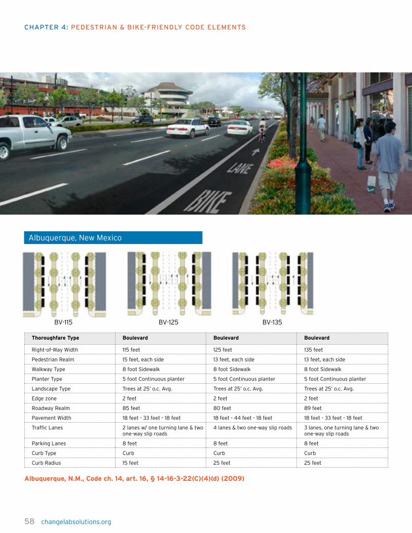
58 changelabsolutions.org
chapTer 4: pedesTrian & Bike-FriendLy code eLeMenTs
Albuquerque, New Mexico
BV-115 BV-125 BV-135
Thoroughfare Type Boulevard Boulevard Boulevard
Right-of-Way Width 115 feet 125 feet 135 feet
Pedestrian Realm 15 feet, each side 13 feet, each side 13 feet, each side
Walkway Type 8 foot Sidewalk 8 foot Sidewalk 8 foot Sidewalk
Planter Type 5 foot Continuous planter 5 foot Continuous planter 5 foot Continuous planter
Landscape Type Trees at 25’ o.c. Avg. Trees at 25’ o.c. Avg. Trees at 25’ o.c. Avg.
Edge zone 2 feet 2 feet 2 feet
Roadway Realm 85 feet 80 feet 89 feet
Pavement Width 18 feet - 33 feet - 18 feet 18 feet - 44 feet - 18 feet 18 feet - 33 feet - 18 feet
Traffic Lanes 2 lanes w/ one turning lane & two one-way slip roads
4 lanes & two one-way slip roads 3 lanes, one turning lane & two one-way slip roads
Parking Lanes 8 feet 8 feet 8 feet
Curb Type Curb Curb Curb
Curb Radius 15 feet 25 feet 25 feet
Albuquerque, N.M., Code ch. 14, art. 16, § 14-16-3-22(C)(4)(d) (2009)

changelabsolutions.org 59
Streets: Safe CrossingsPedestrians must be able to cross streets safely. More
than 40 percent of pedestrian fatalities take place where
no crosswalk is available. Often, marked crosswalks alone
are insufficient to protect pedestrians, and additional
infrastructure is necessary to make the crossing safe.
Crosswalk signal timing should be designed to allow
potentially vulnerable populations, such as older adults,
adequate time to cross and, wherever possible, the signals
should have countdown clocks. In areas with long blocks,
or where pedestrians use both sides of the street heavily,
crosswalks located both in the middle and at the end of
blocks are helpful.
However, mid-block crossings can be particularly
dangerous because drivers may not anticipate or see
pedestrians. Dangerous crossings can be made safer by
installing features like signals, signage, crosswalk striping,
flashing beacons or pedestrian-activated traffic signals,
curb extensions or bulbouts, and median refuges.
There are additional safety considerations for crossings.
Ramps and curb cuts leading to crossings should
feature high-contrast detectable warning strips to alert
pedestrians, particularly those who may be vision-
impaired, that they are approaching traffic. Bus stops
should be located after crosswalks so that transit riders
crossing the street for a bus stop won’t be hit by a bus,
and so that stopped buses don’t block drivers’ view of
pedestrians in crosswalks.
Code ExamplesLouisville, Kentucky, requires pedestrian connectivity to
destination uses (such as schools, parks, and shopping
areas) by requiring a 10 foot pedestrian easement through
non-residential blocks or a 10 foot walkway for residential
blocks greater than 800 feet in length. Hailey, Idaho,
utilizes a range of strategies to create safer pedestrian
conditions such as the provision of medians, signals,
increased crossing times, and curb extensions.
Louisville, Kentucky
All new blocks created by any major subdivision of
land hereafter proposed shall conform to the following
standards of design:
A. Pedestrian Access — Sidewalks bisecting non-residential
blocks may be required within non-residential blocks
where necessary to improve pedestrian circulation by
providing more convenient access to schools, parks,
shopping, etc., than is possible with sidewalks within the
street right-of-way. Such walkways shall have an easement
width of at least ten feet.
B. Mid-block Walkways — When residential blocks are over
800 feet in length, a walkway bisecting the block and
dedicated to public use not less than ten feet wide, may be
required to provide proper access to schools, playgrounds,
shopping centers and other facilities.
Louisville, Ken., Land Dev. Code, § 7.3.20 (2009)

60 changelabsolutions.org
chapTer 4: pedesTrian & Bike-FriendLy code eLeMenTs
Hailey, Idaho
Form Based Code: Street Design
1. Design Solutions at Wide Intersections. The following
techniques are appropriate to use to improve pedestrian
conditions and access at wide intersections, particularly
on Main Street where appropriate right-of-way exists, and
maybe incorporated into a design:
a. Center medians to provide a refuge for slower pedestrians;
b. Accessible pedestrian signals to assist in providing people
with vision impairments enough time to cross the street;
c. Increase crossing times so that people who walk
slowly will have sufficient time to cross before the signal
indication changes;
d. Increase the crossing times so that people who delay
the start of their crossing to confirm the WALK interval
will have sufficient time to cross before the signal
indication changes;
e. Prohibit left turns during the WALK interval;
f. Restrict right turns on red;
g. Enhance the visibility of the crosswalk markings or
consider a raised crosswalk with detectable warnings
(truncated domes) at both ends;
h. Reduce crossing distances and increase visibility
through the construction of curb extensions;
i. Reduce traffic speed;
j. Clarify the pedestrian crossing area by installing
stamped or raised crosswalks with detectable warnings
(truncated domes) installed at both ends;
k. Pedestrian lead time and an accessible pedestrian signal
so pedestrians, including those with vision impairments,
can assert themselves in the crosswalk before motorists
start making right and left turns;
l. Mid-block signalized crossing with accessible pedestrian
signal opportunities at busy intersections to encourage
people to cross where there are fewer potential points of
conflict between pedestrians and motorists;
m. Traffic and pedestrian signal indications if they do not
already exist.
Hailey, Idaho. Municipal Code, Mobility Design. Chapt 18
§18.06.016 (E)(1) (2012)
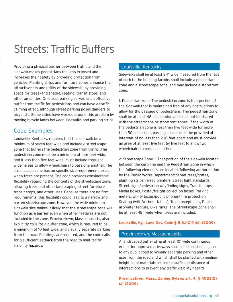
changelabsolutions.org 61
Streets: Traffic BuffersProviding a physical barrier between traffic and the
sidewalk makes pedestrians feel less exposed and
increases their safety by providing protection from
vehicles. Planting strips and furniture zones enhance the
attractiveness and utility of the sidewalk, by providing
space for trees (and shade), seating, transit stops, and
other amenities. On-street parking serves as an effective
buffer from traffic for pedestrians and can have a traffic
calming effect, although street parking poses dangers to
bicyclists. Some cities have worked around this problem by
moving bicycle lanes between sidewalks and parking strips.
Code ExamplesLouisville, Kentucky, requires that the sidewalk be a
minimum of seven feet wide and include a streetscape
zone that buffers the pedestrian zone from traffic. The
pedestrian zone must be a minimum of four feet wide,
and if less than five feet wide, must include frequent
wider areas to allow wheelchairs to pass one another. The
streetscape zone has no specific size requirement, except
when trees are present. The code provides considerable
flexibility regarding the contents of the streetscape zone,
allowing trees and other landscaping, street furniture,
transit stops, and other uses. Because there are no firm
requirements, this flexibility could lead to a narrow and
barren streetscape zone. However, the wide minimum
sidewalk size makes it likely that the streetscape zone will
function as a barrier even when other features are not
included in the zone. Provincetown, Massachusetts, also
explicitly calls for a buffer zone, which is required to be
a minimum of 10 feet wide, and visually separate parking
from the road. Plantings are required, and the code calls
for a sufficient setback from the road to limit traffic
visibility hazards.
Louisville, Kentucky
Sidewalks shall be at least 84” wide measured from the face
of curb to the building facade, shall include a pedestrian
zone and a streetscape zone, and may include a storefront
zone.
1. Pedestrian zone. The pedestrian zone is that portion of
the sidewalk that is maintained free of any obstructions to
allow for the passage of pedestrians. The pedestrian zone
shall be at least 48 inches wide and shall not be shared
with the streetscape or storefront zones. If the width of
the pedestrian zone is less than five feet wide for more
than 50 linear feet, passing spaces must be provided at
intervals of no less than 200 feet apart and must provide
an area of at least five feet by five feet to allow two
wheelchairs to pass each other.
2. Streetscape Zone — That portion of the sidewalk located
between the curb line and the Pedestrian Zone in which
the following elements are located, following authorization
by the Public Works Department: Street trees/grates,
planting strips, raised planters, Street light standards,
Street signs/pedestrian wayfinding signs, Transit stops,
Media boxes, Postal/freight collection boxes, Parking
meters, Utility boxes/public phones/ fire protection,
Seating (with/without tables), Trash receptacles, Public
art/water feature, Bike racks. The Streetscape Zone shall
be at least 48” wide when trees are included.
Louisville, Ky., Land Dev. Code § 5.8.1(C)(1)(b) (2009)
Provincetown, Massachusetts
A landscaped buffer strip at least 10’ wide continuous
except for approved driveways shall be established adjacent
to any public road to visually separate parking and other
uses from the road and which shall be planted with medium
height plant materials set back a sufficient distance at
intersections to prevent any traffic visibility hazard.
Provincetown, Mass., Zoning Bylaws art. 4, § 4053(2)
(a) (2009)

62 changelabsolutions.org
chapTer 4: pedesTrian & Bike-FriendLy code eLeMenTs
Streets: Traffic CalmingFor decades, streets have been designed with the primary
goal of moving cars as quickly as possible. But high-speed
driving environments increase the number of collisions
and the severity of injuries, both for motorists and for
pedestrians.
Reducing how rapidly cars drive on a street is crucial
not only for pedestrian safety, but also for the livability
and social and recreational functions of a street. To
reduce traffic speed and increase pedestrian visibility,
communities can introduce narrow streets, roundabouts,
medians, speed humps, street signs alerting drivers to the
presence of pedestrians, and bulbouts at places where
pedestrians cross the street.
Code ExampleSan Antonio acknowledges that street design can lead to
excessive speeds, and provides for various traffic calming
devices, such as bulbouts, roundabouts, and median
islands. The city’s code permits longer length streets
where there are traffic calming features.
Las Cruces, New Mexico, details a procedure for
evaluating and implementing traffic calming measures
for residential streets in the city. In addition to describing
data for inclusion in a traffic calming study, the design
guidelines include descriptions of the potential benefits
or disadvantages and costs for a range of traffic calming
measures. Traffic calming measures range from more
affordable options such as speed humps to higher value
investments like traffic circles.
San Antonio, Texas
Traffic Calming. The purpose of this section, is to protect
the public health, safety and general welfare by ensuring
that speeds on local streets are suitable for their intended
purpose. The city hereby finds and determines that long
blocks, wide street cross sections and uninterrupted
traffic flows can encourage speeding on local streets.
Accordingly, these design standards will slow traffic on
local streets while allowing flexibility in design and offering
applicants the choice of treatment that works best for the
streets in a proposed development.
(3) Traffic Control Calming Features. A longer street
length may be allowed through the placement of an
approved traffic calming feature at a location which
produces an unimpeded length of the street link which
does not exceed the block length standards (subsection
35-515(b)(4)). Table 506-8 provisions describe and
establish standards for permitted traffic calming devices
[such as bulbouts, roundabouts, speed humps, median
islands, t-intersections] where traffic calming measures
are permitted as part of the roadway design elements.
San Antonio, Tex., Unified Dev. Code art. V, div. 2,
§ 35-506(t)(3)(2009)
changelabsolutions.org 63
Las Cruces, New Mexico
CHOKER:
a. Definition. A physical constriction built at the curbside
of the roadway effectively reducing the width of the travel
lane.
b. Placement. Normal turning radii should be
accommodated. Visibility should be a key design
consideration with features such as advance warning
signs, reflective channelization, reflectors on curbs and
elevated landscape elements.
c. Advantages. Effective lane narrowing results in lower
speeds, provides parking protection, and shortens
pedestrian crossing distance.
With landscape enhancements, improves aesthetic value of
intersection.
d. Disadvantages. Potential drainage problems; increases
maintenance costs.
RAISED CROSSWALK:
a. Definition. A raised hump (a pavement undulation) in
the roadway with an eight-foot to ten-foot’ wide flat top,
extending across the road perpendicular to the direction
of traffic flow. The top is typically striped with MUTCD-
compliant crosswalk markings.
b. Placement. Where significant number of pedestrians
(ten—20 per hour in a minimum four-hour period of a typical
day) cross the roadway with 85th percentile speeds greater
than 30 mph, speed hump placing considerations apply.
c. Advantages. Effectively reduces speeds, provides
improved visibility for crossing pedestrians.
d. Disadvantages. Slows emergency vehicles and buses;
increases noise and maintenance cost.
TRAFFIC CIRCLE:
a. Definition. A circular intersection which provides
counter-clockwise, one way operations by placing
an elevated area in the middle of the intersection.
Approaching vehicles yield to traffic already in the circle.
b. Placement. Street grades approaching the intersection
should not exceed ten percent.
c. Advantages. Effectively reduces speeds, fewer left-turn
crashes, can be visually attractive.
With landscape enhancements, improves aesthetic value
of intersection.
d. Disadvantages. Placement of circle may require parking
removal.
CROSSWALK REFUGE:
a. Definition. A physical constriction (a median) built in
the middle of the roadway with a cut provided for the
crosswalk.
b. Placement. Where significant number of pedestrians
(minimum of ten—20 pedestrians per hour for a minimum
four hours of a typical day) cross the roadway. Special
consideration can be given to designated school walking
routes.
c. Advantages. Provides refuge for pedestrians when
crossing the roadway; effective lane narrowing results
in lower speeds. May allow space for landscape
enhancements with increased aesthetic value of the
crossing point.
d. Disadvantages. Increases maintenance cost.
CHICANE:
a. Definition. Physical constrictions (three/set) built at the
curbside of the roadway to create a 45-degree bend in a
formerly straight street. This forces cars to negotiate the
narrowed street in a snake-like fashion. The 45-degree
bend can also be achieved by alternating parking from one
side of the street to the other.
b. Placement. Normal turning radii should be
accommodated. Chicane sets are to be placed 400—600
feet apart. Visibility should be a key design consideration
with features such as advance warning signs, reflective
channelization, curb-mounted reflectors, and elevated
landscape.

64 changelabsolutions.org
chapTer 4: pedesTrian & Bike-FriendLy code eLeMenTs
c. Advantages. The snake-like alignment and the lane
narrowing result in lower speeds provide parking
protection, shorten pedestrian crossing distance.
With landscape enhancements, improves aesthetic value
of street.
d. Disadvantages. May contribute to head-on collisions,
potential drainage problems and higher maintenance costs.
DIVERTER:
a. Definition. Physical barrier constructed to completely
restrict passage of traffic and/or disallow certain
movements through an intersection.
b. Advantages. Effective control in reducing traffic
volumes.
c. Disadvantages. Placement of diverters can have an
adverse impacts to local traffic.
STREET TREES:
Street trees planted along both sides of the street ROW
can make the street appear narrower than it is and can
result in traffic calming. Landscaping and street trees have
been shown to reduce traffic speeds by creating a more
pedestrian-friendly and enclosed environment. Vertical
elements such as street trees serve to alert vehicles to the
presence of pedestrians, and cause them to reduce their
speeds. Street trees and a landscaping strip are often used
in conjunction with other traffic calming techniques such
as traffic diverters and chicanes.
Las Cruces, NM. Ord. No. 2663, § I(exh. A), 9-4-12

changelabsolutions.org 65
Streets: TreesGood street shade trees have a large canopy that
hangs relatively low but is high enough not to endanger
pedestrians walking underneath. Placed between the
street and the sidewalk, shade trees provide a physical and
psychological barrier between vehicles and pedestrians.
When properly spaced, shade trees offer a continuous
canopy of shade that adds to pedestrian comfort and
physical well-being, especially in warm climates. Shade
trees give a sidewalk a sense of security and enclosure,
add natural color and beauty, mitigate storm water runoff,
and improve air quality.
Urban forestry projects can also qualify as carbon offset
credits in California’s cap and trade market if certain
requirements are met, such as a 100 year lifespan for the
trees and an average spacing of no less than five meters.
Shade trees can thereby raise some money for local
governments as well as mitigating some greenhouse gas
emissions.
Code ExamplesBoth Arlington and Peoria require that street trees
be spaced at an average spacing of not more than 30
feet apart, a distance that meets street tree spacing
recommendations.
Arlington County, Virginia, requires trees on every street
within the design area. Arlington also requires a minimum
amount of unpaved ground, in order to promote health of
the trees, and requires the trees be a minimum size when
planted. Peoria, Illinois, makes developers responsible for
planting trees along the property that is being developed.
Peoria allows some flexibility in spacing of trees, but
prohibits spacing more than 45 feet apart. In a related
provision, Peoria requires a minimum unpaved area per
tree, and also requires the bare ground to be covered with
a plant groundcover.
Arlington County, Virginia
Each STREET shall have canopy shade trees (STREET
TREES). Wherever the REGULATING PLAN does not show
specific STREET TREE placement, STREET TREES shall be
planted along the STREET TREE ALIGNMENT LINE at an
average spacing not greater than 25 to 30 feet on center
(measured per BLOCK face). Required tree planting area
widths are specified on the typical street cross sections in
the Master Transportation Plan – Part I. However, open soil
surface area shall be not less than 60 square feet (with a
minimum of 5 feet in any direction) per isolated tree, and
connected (tree strip) planting areas are encouraged. The
planting area’s minimum dimension shall be not less than
5 feet. At planting, trees shall be at least 4 to 4.5 inches in
diameter (4 feet above grade) and at least 12 feet in overall
height. Species shall be selected from the Columbia Pike
Special Revitalization District Street Tree List. Consult the
ADMINISTRATIVE REVIEW TEAM for the designated tree
species for a particular STREET.
Arlington County, Va., Zoning Ordinance § 20, app. A
(V)(B) (2009)
Peoria, Illinois
At the time of development, the applicant is responsible
for installing/planting the following street trees in the
space fronting their property between the required
building line and the travel lane: … Each street-space shall
have street trees planted along the street tree alignment
line (generally three feet, six inches from the back of the
curb) at an average spacing not greater than 30 feet on
center (measured per block face). Required tree planting
area widths are specified in the Street Type Specifications
or on the regulating plan. Where necessary, spacing
allowances may be made to accommodate curb cuts, fire
hydrants and other infrastructure elements, however, at no
location shall spacing exceed 45 feet on center.
Peoria, Ill., Code app. C, § 6.8.3(b) (2009)

66 changelabsolutions.org
chapTer 4: pedesTrian & Bike-FriendLy code eLeMenTs
Trail NetworksWell-connected bike paths and lanes can facilitate longer
commutes and even encourage non-commuters to use
their bicycles. Bicycle infrastructure, especially paths
that separate bicycle from vehicular traffic, creates safer
environments for all motorists by reducing potential for
accidents and collisions. Transportation networks should
provide continuous, well-maintained, and direct bicycle
connections to key activity centers such as schools,
commercial areas, and other public spaces.
Code ExamplesMontgomery County, Maryland, utilizes a handful of
strategies to create pedestrian and bicycle friendly rural
village centers. The overlay zone emphasizes the need for
pedestrian and bicycle connectivity. In contrast, the code
in Seminole County, Florida, outlines a comprehensive
list of strategies selected to ensure transit supportive
planning for all users including the elderly and the
disabled. Strategies include clustering a mix of compatible
land uses around transit stations, orienting buildings
toward transit facilities, and providing safe and direct
pedestrian and bicycle connections to transit.
Montgomery County, Maryland
It is the purpose of this overlay zone to create attractive,
cohesive, and pedestrian-friendly rural village centers,
consisting of a mix of uses as allowed in the underlying
zones, as limited in this section. Specifically, the overlay
zone is designed to:
(a) Draw upon the open, green character of the
surrounding area, emphasizing this character through
streetscape design, open space, and landscaping.
(b) Maintain and enhance the rural village character
through compatible scale, massing, siting, and setbacks for
new and expanded uses.
(c) Emphasize the pedestrian and bicycle circulation
through street design, including streetscape and traffic
calming, and trail networks.
(d) Encourage a variety of uses that serve the needs
of the local community, including mixed-use buildings
that provide housing and commercial uses to the extent
allowed in the underlying zone.
Montgomery County, MD. Zoning Code. § 59-C-18.23
Seminole County, Florida
Transit service must be competitive with the automobile in
terms of access, cost, convenience, comfort, security and
safety if it is to be successful. Therefore, transit service
must be planned, designed and operated to respond to
customer needs. Transit can be successful in attracting
a significant number of users from the automobile if
it provides user-oriented service. The planning and
development of land use patterns and site designs that
are sensitive to the needs of potential transit users can
create a user-friendly environment which will enhance
the attractiveness of transit. Transit compatible land use
planning includes the following features:
(g) Provide for safe, convenient pedestrian and bicycle
circulation with direct, logical connections between
buildings and transit stops/stations.
Seminole County, Fla. Land Dev. Code. Appendix A.
§ 14.3.g
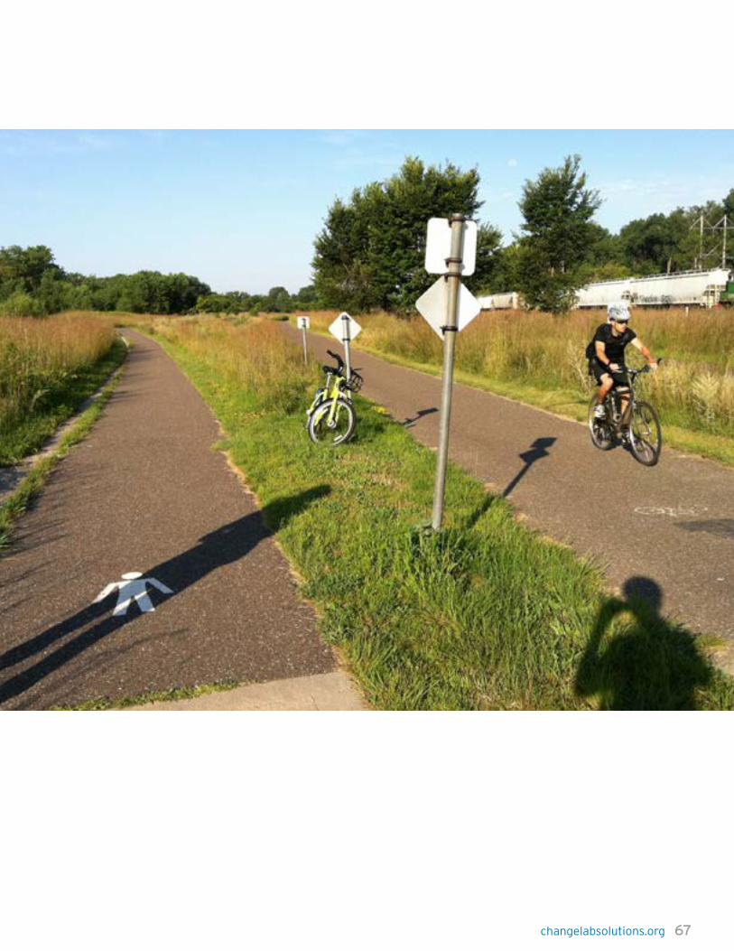

68 changelabsolutions.org
chapTer 4: pedesTrian & Bike-FriendLy code eLeMenTs
Transit: AccessPublic transportation and walking complement each other,
since transit users generally walk to and from transit, and
transit increases the distance pedestrians can travel.
Communities can arrange transit stops around popular
destinations such as grocery stores and community centers.
Transit stops should be within 1/4 to 1/2 mile of destinations
and residences, especially for residences or destinations
of older adults and low-income families as they are less
likely to own cars and have difficulty walking beyond these
distances. When communities can meet these needs,
public transportation becomes much more convenient for
those who rely on it, and more attractive for those who
might otherwise drive.
Areas surrounding transit centers benefit from increased
foot traffic, which leads to an increase in local purchases
and a decrease in automobile traffic. It’s also important
to provide the areas near transit stops with crosswalks
and other pedestrian-friendly features to ensure that
passengers are safe when walking to and from transit.
Code ExamplesSan Diego’s general language calls for locating transit
stops to “maximize access” and optimize pedestrian and
cycling connectivity. The code provides more specificity
in the context of major activity zones, stating that stops
should be every quarter-mile in such areas.
Lauderhill, Florida, regulates the spacing, location, and
design of future bus stops to maximize transit efficiency
while encouraging pedestrian access and safety.
San Diego, California
Locate transit stops to maximize access and optimize
transit service and pedestrian and bikeway connections.
Where located near cross-roads and major activity centers,
stops should be at one-quarter mile intervals.
San Diego, Cal., Mun. Code ch. 15, art. 14, div. 4,
§ 1514.0408(j)(1) (2009)
Lauderhill, Florida
Review criteria. The following four criteria shall be
considered in determining whether a special permit for a
bus stop shall be granted:
1. Access.
a. Proximity to major trip generators.
b. Availability of sidewalks, crosswalks and curb ramps.
c. Connection to nearby pedestrian circulation system.
d. American with Disability Act accessibility.
e. Convenient passenger transfer to other routes.
2. Traffic and safety.
a. Conflict between buses and other traffic.
b. Passenger protection from passing traffic.
c. Availability of all weather surface to step on and off
the bus.
d. Open and lighted spaces for personal security and
passenger illumination.
e. Street and sidewalk illumination.
Lauderhill, FL, Land Development Regulations, art.III,
§ 5.46

changelabsolutions.org 69
Transit: FacilitiesMore people use public transportation when transit
facilities are attractive, safe, and functional. To make
them more appealing and to optimize use, transit stops
should be highly visible to pedestrians, and oncoming
transit vehicles should be easy to see from the stop.
Facilities should have some architectural verve to enhance
the streetscape, provide benches and shelter from the
elements, and address the challenges posed by local
weather (for example, by including heating in cold climates).
Code ExamplesSan Diego requires very simply that transit stops be
attractive, visible, and provide shelter from the elements.
The code also requires that developments along transit
corridors include bicycle parking, benches, and other
pedestrian-friendly features.
Minneapolis uses an incentive system to provide a much
more comprehensive set of requirements in terms of
functionality and usability of the transit stop itself.
Developers can obtain floor area ratio premiums by
building and maintaining transit facilities that meet a
number of requirements. Facilities must include heat, light,
and shelter, and must provide high visibility. In addition,
facilities must contain resting spaces for 30 percent of
the projected peak demand, and must be visually tied
into related principal structures. These requirements
reflect weather and comfort requirements necessary to
accommodate transit riders year round in Minneapolis.
San Diego, California
(2) Design transit stops to be attractive, highly visible and
provide shelter. Transit stop design and location should be
acceptable to MTDB [Metropolitan Transit Development
Board].
(3) Include transit shelters, bicycle parking facilities,
canopies, patterned sidewalks, information kiosks, benches
and other pedestrian amenities in developments located
along transit corridors. Enhanced transit shelters are
desirable.
San Diego, Cal., Mun. Code §§ 1514.0408 Guidelines for
Discretionary Review (j)(2)–(3) (2009)
Minneapolis, Minnesota
Transit facility, subject to the following standards:
(c.) The transit facility shall be similar to the principal
structure in design and materials, shall be weather
protected, heated and lighted, and shall contain at least
two (2) entries.
(d.) The transit facility shall be clearly visible from the
street and sidewalk, and transit users shall be able to see
oncoming transit vehicles from the facility.
(e.) The transit facility shall contain a combination of
leaning rails and seating for at least thirty (30) percent of
projected peak demand, trash receptacles and connections
for transit schedule monitors.
Minneapolis, Minn., Code tit. 20, ch. 549, art II
§ 549.220(5)(c,d,e) (2009)
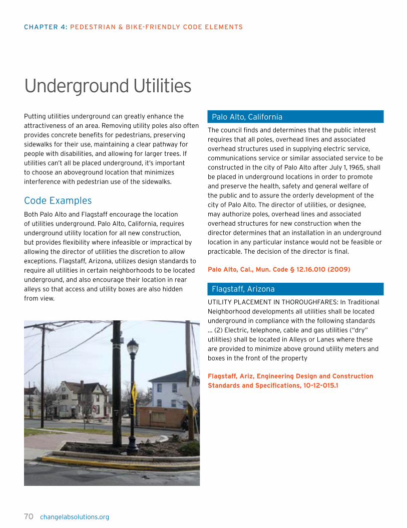
70 changelabsolutions.org
chapTer 4: pedesTrian & Bike-FriendLy code eLeMenTs
Underground UtilitiesPutting utilities underground can greatly enhance the
attractiveness of an area. Removing utility poles also often
provides concrete benefits for pedestrians, preserving
sidewalks for their use, maintaining a clear pathway for
people with disabilities, and allowing for larger trees. If
utilities can’t all be placed underground, it’s important
to choose an aboveground location that minimizes
interference with pedestrian use of the sidewalks.
Code ExamplesBoth Palo Alto and Flagstaff encourage the location
of utilities underground. Palo Alto, California, requires
underground utility location for all new construction,
but provides flexibility where infeasible or impractical by
allowing the director of utilities the discretion to allow
exceptions. Flagstaff, Arizona, utilizes design standards to
require all utilities in certain neighborhoods to be located
underground, and also encourage their location in rear
alleys so that access and utility boxes are also hidden
from view.
Palo Alto, California
The council finds and determines that the public interest
requires that all poles, overhead lines and associated
overhead structures used in supplying electric service,
communications service or similar associated service to be
constructed in the city of Palo Alto after July 1, 1965, shall
be placed in underground locations in order to promote
and preserve the health, safety and general welfare of
the public and to assure the orderly development of the
city of Palo Alto. The director of utilities, or designee,
may authorize poles, overhead lines and associated
overhead structures for new construction when the
director determines that an installation in an underground
location in any particular instance would not be feasible or
practicable. The decision of the director is final.
Palo Alto, Cal., Mun. Code § 12.16.010 (2009)
Flagstaff, Arizona
UTILITY PLACEMENT IN THOROUGHFARES: In Traditional
Neighborhood developments all utilities shall be located
underground in compliance with the following standards
… (2) Electric, telephone, cable and gas utilities (“dry”
utilities) shall be located in Alleys or Lanes where these
are provided to minimize above ground utility meters and
boxes in the front of the property
Flagstaff, Ariz, Engineering Design and Construction
Standards and Specifications, 10-12-015.1
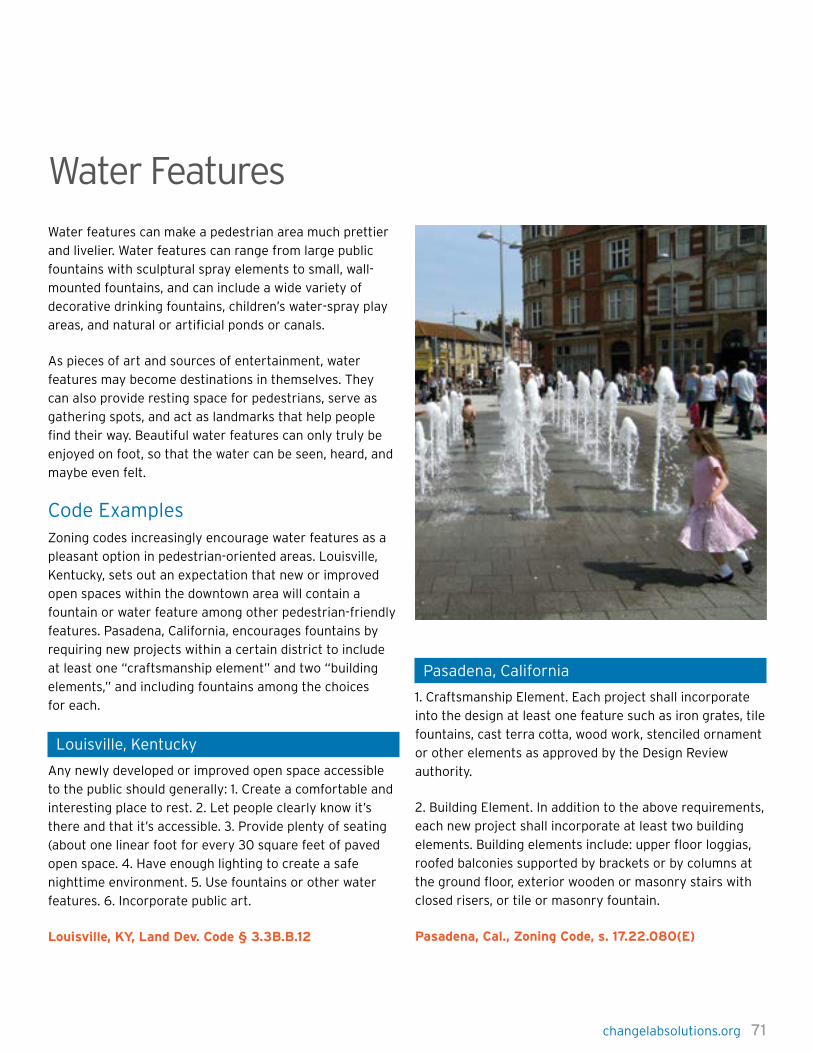
changelabsolutions.org 71
Water FeaturesWater features can make a pedestrian area much prettier
and livelier. Water features can range from large public
fountains with sculptural spray elements to small, wall-
mounted fountains, and can include a wide variety of
decorative drinking fountains, children’s water-spray play
areas, and natural or artificial ponds or canals.
As pieces of art and sources of entertainment, water
features may become destinations in themselves. They
can also provide resting space for pedestrians, serve as
gathering spots, and act as landmarks that help people
find their way. Beautiful water features can only truly be
enjoyed on foot, so that the water can be seen, heard, and
maybe even felt.
Code ExamplesZoning codes increasingly encourage water features as a
pleasant option in pedestrian-oriented areas. Louisville,
Kentucky, sets out an expectation that new or improved
open spaces within the downtown area will contain a
fountain or water feature among other pedestrian-friendly
features. Pasadena, California, encourages fountains by
requiring new projects within a certain district to include
at least one “craftsmanship element” and two “building
elements,” and including fountains among the choices
for each.
Louisville, Kentucky
Any newly developed or improved open space accessible
to the public should generally: 1. Create a comfortable and
interesting place to rest. 2. Let people clearly know it’s
there and that it’s accessible. 3. Provide plenty of seating
(about one linear foot for every 30 square feet of paved
open space. 4. Have enough lighting to create a safe
nighttime environment. 5. Use fountains or other water
features. 6. Incorporate public art.
Louisville, KY, Land Dev. Code § 3.3B.B.12
Pasadena, California
1. Craftsmanship Element. Each project shall incorporate
into the design at least one feature such as iron grates, tile
fountains, cast terra cotta, wood work, stenciled ornament
or other elements as approved by the Design Review
authority.
2. Building Element. In addition to the above requirements,
each new project shall incorporate at least two building
elements. Building elements include: upper floor loggias,
roofed balconies supported by brackets or by columns at
the ground floor, exterior wooden or masonry stairs with
closed risers, or tile or masonry fountain.
Pasadena, Cal., Zoning Code, s. 17.22.080(E)

72 changelabsolutions.org
chapTer 4: pedesTrian & Bike-FriendLy code eLeMenTs
Model CodesThe following model code examples reflect some of the
most important components of a safe and comfortable
pedestrian and cyclist experience. They are provided as
a starting point for toolkit users looking to improve their
existing zoning or subdivision codes.
Pedestrian-Oriented EntrancesPrincipal building entrances shall be located on the street
frontage of the building. However, for buildings fronting
other public spaces, such as public squares or plazas, the
principal entrance may face the public space; some public
entrance must face the public space. In addition, entrances
must be provided at intervals no greater than [75] feet
along a street to maximize street activity, to provide
pedestrians with frequent opportunities to enter buildings,
and to minimize any expanses of inactive wall.
Building Facade 1. At least [30] percent of the facade of each story of a
building must consist of transparent windows or doors.
For windows to be considered transparent, the window
glass must transmit at least 50 percent of visible daylight.
For retail stores, the ground story must have transparent
storefront windows covering no less than [75] percent of
its facade in order to provide clear views of merchandise
in stores and to provide natural surveillance of exterior
street spaces.
2. The building facade shall be built to the [required
building/street property] line for at least [80] percent of
the building length.
Pedestrian-Oriented LightingLighting shall be designed and located at a pedestrian
scale consistent with pedestrian movements and the
neighborhood. Lighting shall be placed at [15] feet or
lower, and shall be concealed or shielded to avoid glare
and off-site impacts on abutting properties.
Street TreesEach street shall have street trees that provide canopy
and shade. Street trees shall be planted along the street
tree alignment line at an average spacing not greater than
[25-30] feet on center. Open soil surface area shall be not
less than [60] square feet (with a minimum of [3-5] feet in
any direction) per isolated tree, and connected (tree strip)
planting areas are encouraged. At planting, trees shall be
at least 4 to 4.5 inches in diameter (4 feet above grade)
and at least 12 feet in overall height. Where necessary,
spacing allowances may be made to accommodate curb
cuts, fire hydrants and other infrastructure elements,
however, at no location shall spacing exceed [45] feet
on center.
Landscape BuffersA landscaped buffer strip at least [5] feet wide, planted
with street trees and medium height plant materials, shall
be established adjacent to streets to provide a buffer to
pedestrians and to visually separate uses from the street.
changelabsolutions.org 73
Appendix A: ResourcesThe following model policy resources may aid in your
efforts to create more walkable, bikeable, and transit
friendly communities:
Model Complete StreetsConventional street design promotes traffic congestion,
pollution, and collisions, and discourages physical activity.
Complete streets, on the other hand, are designed and
built so that people of all ages and abilities can travel
easily and safely, while also getting the regular physical
activity that is so critical to preventing obesity. ChangeLab
Solutions has developed model laws and resolutions to
help communities embrace complete streets, no matter
how new or experienced they are with this idea.
Complete streets model policies are available at
www.changelabsolutions.org/publications/
laws-resolutions-cs
Model Bicycle Parking OrdinanceOne clear impediment to bicycle use, however, is that most
cities lack sufficient safe and convenient bicycle parking.
Just as drivers need easy, secure parking, so do bicyclists.
ChangeLab Solutions has developed a model bicycle
parking ordinance to help local communities increase the
availability and quality of bicycle parking, creating a more
bike-friendly environment. Download our fact sheet below
for a more complete overview, and contact us for help
adapting the model ordinance to your community’s needs.
The Model Bicycle Parking Ordinance is available at
www.changelabsolutions.org/publications/bike-parking
New York City Active Design GuidelinesImplementing active transportation policies requires
strong, evidence-based design practices. A partnership
of New York City government agencies and professional
groups developed a manual of strategies for building
healthier neighborhoods and encouraging active living
through building design. Information about trainings on
the guidelines is also available at the link below.
The New York City Active Design Guidelines are available at
www.centerforactivedesign.org/guidelines/
ENACT Local Policy DatabaseAdditional best practices can be found in this searchable
database of local physical activity and nutrition policies,
compiled by Prevention Institute and maintained by
the Strategic Alliance for Healthy Food and Activity
Environments. The database is searchable by topic,
keyword, state, jurisdiction, year and environment (e.g.
school, workplace).
The ENACT Local Policy Database can be found at
www.eatbettermovemore.org/sa/policies/
This toolkit was developed with support from the Centers
for Disease Control and Prevention. Its contents are solely
the responsibility of the authors and do not necessarily
represent the official views of the Centers for Disease
Control and Prevention.
Users of this document should be aware that every funding
source has different requirements governing the appropriate
use of those funds. Under U.S. law, no federal funds are
permitted to be used for lobbying or to influence, directly or
indirectly, specific pieces of pending or proposed legislation
at the federal, state, or local levels. Organizations should
consult appropriate legal counsel to ensure compliance with
all rules, regulations, and restriction of any funding sources.

74 changelabsolutions.org
Endnotes1. Bassett DR, Pucher J, Buehler R, Thomson DL and Crouter SE. “Walking, Cycling, and Obesity Rates in Europe, North
America, and Australia.” Journal of Physical Activity and Health, 5: 795-814, 2008.
2. Frank L, Andersen MA, and Schmid TL. “Obesity Relationships with Community Design, Physical Activity, and Time
Spent in Cars.” American Journal of Preventive Medicine, 27(2): 87-96, 2004.
3. Centers for Disease Control and Prevention. FastStats, Obesity and Overweight. 2011.
www.cdc.gov/nchs/fastats/overwt.htm/
4. Centers for Disease Control and Prevention, Adolescent and School Health, Childhood Obesity Facts. 2012.
www.cdc.gov/healthyyouth/obesity/facts.htm
5. Centers for Disease Control and Prevention. Obesity: Halting the Epidemic by Making Health Easier: At a Glance:
2011. National Center for Chronic Disease Prevention and Health Promotion: Division of Nutrition, Physical Activity,
and Obesity. www.cdc.gov/chronicdisease/resources/publications/aag/pdf/2011/Obesity_AAG_WEB_508.pdf
6. National Highway Traffic Safety Administration. “2010 Motor Vehicle Crashes: Overview.” Traffic Safety Facts:
Research Notes. Washington D.C.: U.S. Department of Transportation. 2012 February.
7. Reynolds CCO, Harris MA, Teschke K, et al. “The Impact of Transportation Infrastructure on Bicycling Injuries and
Crashes: A Review of the Literature.” Environmental Health, 8:47, 2009.
8. Clifton KJ, Burnier CV and Akar G. “Severity of Injury Resulting from Pedestrian-Vehicle Crashes: What Can
We Learn from Examining the Built Environment?” Transportation Research Part D: Transportation and the
Environment. 14(6):425-436, 2009.
9. Jerrett et al. “Traffic-Related Air Pollution and Asthma Onset in Children: A Prospective Cohort Study with Individual
Exposure Measurement.” Environmental Health Perspectives, 116:1433-1438, 2008.
10. CARB. Health Effects of Diesel Exhaust Particulate Matter. 2006. www.arb.ca.gov/research/diesel/dpm_draft_3-01-06.pdf
11. Environmental Protection Agency. Our Built and Natural Environments: A Technical Review of the Interactions
Between Land Use, Transportation, and Environmental Quality. U.S. Environmental Protection Agency. 2001.
www.epa.gov/smartgrowth/pdf/built_chapter3.pdf
12. CARB, supra note 7.
13. EPA, supra note 8.
14. U.S. Climate Change Science Program and the Subcommittee on Global Climate Change Research. Analyses of
the Effects of Global Change on Human Health and Welfare and Human Systems (SAP 4.6). U.S. Environmental
Protection Agency, Washington, D.C., 2008.
15. Ewing R, Pendall R and Chen D. Measuring Sprawl and Its Impact: Volume I. Smart Growth America, 2002.
www.smartgrowthamerica.org/documents/MeasuringSprawlTechnical.pdf
16. Heath GW, Brownson RC, Kruger J, et al. “The Effectiveness of Urban Design and Land Use and Transport Policies
and Practices to Increase Physical Activity: A Systematic Review.” Journal of Physical Activity and Health, 3(S1):
S55-S76, 2006.
17. Leyden KM. “Social Capital and the Built Environment: The Importance of Walkable Neighborhoods.” American
Journal of Public Health, 93(9):1546-51, 2003.
18. Wood L, Frank L, and Giles-Corti B. “Sense of Community and its Relationship with Walking and Neighborhood
Design.” Social Science and Medicine, 70(9):1381-1390, 2010.
19. Clifton KJ, Morrissey S, and Ritter C. “Business Cycles: Catering to the Bicycling Market.” TR News. Transportation
Research Board. 280: 26-32, 2012.

changelabsolutions.org 75
20. Local Government Commission Center for Livable Communities. Focus on Livable Communities: The Economic
Benefits of Walkable Communities.
21. National Association of Realtors. The 2011 Consumer Preference Survey: What Americans are looking for when
deciding where to live. 2011. www.realtor.org/reports/2011-community-preference-survey
22. AARP. “AARP Poll: Fighting Gas Prices, Nearly A Third of Americans Age 50+ Hang Up Their Keys To Walk But Find
Streets Inhospitable, Public Transportation Inaccessible.” August 13, 2008. www.aarp.org/about-aarp/press-center/
info-08-2008/aarp_poll_fighting_gas_prices_nearly_a_third_of_am.html (national survey of people over 50 finding
that that 40 percent had no sidewalks); U.S. Department of Transportation, Bureau of Transportation Statistics.
“Sidewalks Promote Walking.” Issue Brief No. 12, 2004 at p.1. www.bts.gov/publications/special_reports_and_issue_
briefs/issue_briefs/number_12/pdf/entire.pdf (national survey showing 66 percent of respondents reporting they
had sidewalks)
23. Ernst M and McCall B. “Mean Streets 2002.” Surface Transportation Policy Project, 2002.
www.transact.org/PDFs/ms2002/MeanStreets2002.pdf
24. Reynolds CCO, Harris MA, Teschke K, et al. “The Impact of Transportation Infrastructure on Bicycling Injuries and
Crashes: A Review of the Literature.” Environmental Health, 8:47, 2009.
25. Leaf WA and Preusser DF. “Literature Review on Vehicle Travel Speeds and Pedestrian Injuries Among Selected
Racial/Ethnic Groups.” US Department of Transportation, National Highway Traffic Safety Administration, 1999.
www.nhtsa.gov/people/injury/research/pub/hs809012.html
26. Davidson KK and Lawson CT. “Do Attributes in the Physical Environment Influence Children’s Physical Activity?
A Review of the Literature.” International Journal of Behavioral Nutrition and Physical Activity, 3:19, 2006.
27. Napier MA, Brown BB, Werner CM and Gallimore J. “Walking to School: Community Design and Child and Parent
Barriers.” Journal of Environmental Psychology, 31(1):45-51, 2011.
28. Groenewegen PP, Van Den Berg AE, de Vries S, and Verheij R. “Vitamin G: Effects of Green Space on Health,
Well-being, and Social Safety.” BMC Public Health, 6:149, 2006.
29. Cohen et al. Park Use and Physical Activity in a Sample of Public Parks in the City of Los Angeles. 2006. RAND
Corporation.
30. Sanchez T. “The Connection Between Public Transit and Employment: The Cases of Portland and Atlanta.” Journal
of the American Planning Association, 65:284-96, 1999; Kawabata M. “Job Accessibility by Travel Mode in US
Metropolitan Areas.” Papers and Proceedings of the Geographic Information Systems Association. 11:115-120, 2002.
31. Frank LD, Saelens BE, Powell KE, and Chapman JE. “Stepping Towards Causation: Do Built Environments or
Neighborhood and Travel Preferences Explain Physical Activity, Driving, and Obesity?” Social Science & Medicine,
65:1898-1914, 2007.
32. Frank L, Andresen MA, and Schmid TL. “Obesity Relationships with Community Design, Physical Activity, and Time
Spent in Cars.” American Journal of Preventative Medicine, 27(2):87-96, 2004.
33. CA Gov’t Code § 66411
34. Washington Policy Center. Trading Roads for Bike Lanes Increases Traffic Congestion. August 30, 2010.
www.washingtonpolicy.org/blog/post/trading-roads-bike-lanes-increases-traffic-congestion
35. Killough III W. “Road Diet Traffic Congestion Continues To Frustrate Locals; Tourists Over Memorial Day Weekend.”
Island Gazette, June 1, 2011. www.islandgazette.net/news-server1/index.php?id=13330:road-diet-traffic-congestion-
continues-to-frustrate-locals-tourists&option=com_content&catid=1:local-news&Itemid=69
36. Levine B. “Road Diet: Strong Objections Challenge Proposed Bicycle Project on Honolulu Avenue.” Glendale
News-Press, June 18, 2012. http://articles.glendalenewspress.com/2012-06-18/news/tn-gnp-0618-strong-objections-
challenge-proposed-bicycle-project-on-honolulu-avenue_1_road-diet-bike-lanes-outreach-meetings

76 changelabsolutions.org
37. U.S. Department of Transportation, Federal Highway Administration. Summary Report: Evaluation of Lane Reduction
“Road Diet” Measures and Their Effects on Crashes and Injuries. March 2004.
www.fhwa.dot.gov/publications/research/safety/humanfac/04082/index.cfm
38. Burden D and Lagerwey P. Road Diets: Fixing the Big Roads. Walkable Communities Inc. 1999.
www.walkable.org/assets/downloads/roaddiets.pdf
39. Broadway Road Diet. www.roaddiet.org/stats.html
40. Infosnack Headquarters. Bike Lanes — Improved or Decreased Safety? September 8, 2008.
www.infosnack.org/2008/09/bike-lanes-improved-or-decreased-safety.html
41. Chen et al. “Evaluating The Safety Effects of Bicycle Lanes in New York City.” American Journal of Public Health,
102(6): 1120-1127, 2012. www.ncbi.nlm.nih.gov/pubmed/22095351
42. Nussbaum P. “More Sidewalks, Bike Lanes Needed to Reduce Pedestrian Deaths:
Study.” The Philadelphia Inquirer. May 24, 2011. http://articles.philly.com/2011-05-24/
news/29578109_1_pedestrian-deaths-pedestrian-danger-index-pedestrian-safety
43. O’Toole R. The Citizens’ Guide to Transportation Reauthorization. CATO Institute. December 10, 2009.
www.cato.org/pubs/bp/bp116.pdf
44. Id.
45. Gotschi T. “Costs and benefits of bicycling investments in Portland, Oregon.” Journal of Physical Activity
and Health, 8(Supp1), S49-S58, 2011. http://journals.humankinetics.com/jpah-supplements-special-issues/
jpah-volume-8-supplement-january/costs-and-benefits-of-bicycling-investments-in-portland-oregon
46. Id.
47. See Rietveld P and Daniel V. “Determinants of Bicycle Use: Do Municipal Policies Matter?” Transportation Research
Part A: Policy and Practice, 38(7): 531–550, August 2004.
48. Dill J and Carr T. “Bicycle Commuting and Facilities in Major U.S. Cities: If You Build Them, Commuters Will Use
Them.” Transportation Research Record, 1828: 116–123, 2003.
49. Evenson K, Herring A and Huston S. “Evaluating Change in Physical Activity with the Building of a Multi–Use Trail.”
American Journal of Preventive Medicine, 28(2,S2): 177–185, February 2005.
50. Huston S, Evenson K, Bors P, et al. “Neighborhood Environment, Access to Places for Activity, and Leisure-Time
Physical Activity in a Diverse North Carolina Population.” American Journal of Health Promotion, 18(1): 58–69,
September/October, 2003.
51. Pierce J, Denison A, Arif A, et al. “Living Near a Trail Is Associated with Increased Odds of Walking Among Patients
Using Community Clinics.” Journal of Community Health, 31(4): 289–302, August 2006.
52. Moudon A, Lee C, Cheadle A, et al. “Cycling and the Built Environment, a US Perspective.” Transportation Research
Part D: Transport and Environment, 10(3): 245–261, May 2005.
53. Centers for Disease Control and Prevention: Office of Minority Health. CDC Health Disparities & Inequalities
Report (CHDIR). Morbidity and Mortality Weekly Report (MMWR) Supplement. 60, January 14, 2011. www.cdc.gov/
minorityhealth/CHDIReport.html#Intro; Morland et al. “Neighborhood Characteristics Associated with the Location
of Food Stores and Food Service Places.” American Journal of Preventive Medicine, 22:23, 23-29, 2002.
www.ncbi.nlm.nih.gov/pubmed/11777675
54. Kirby JB and Kaneda T. “Neighborhood Socioeconomic Disadvantage and Access to Health Care.” Journal of
Health and Social Behavior, 46:15, 15-31, 2005. http://paa2004.princeton.edu/download.asp?submissionId=42001;
Morland et al. “Neighborhood Characteristics Associated with the Location of Food Stores and Food Service Places.”
American Journal of Preventive Medicine, 22:23, 23-29, 2002. www.ncbi.nlm.nih.gov/pubmed/11777675; Altschuler
et al. “Local Services and Amenities, Neighborhood Social Capital, and Health.” Social Science & Medicine, 59:1219,

changelabsolutions.org 77
1219-1229, 2004. www.sciencedirect.com/science/article/pii/S0277953604000; Carpiano RM. “Neighborhood Social
Capital and Adult Health: An Empirical Test of a Bourdieu-Based Model.” Health & Place, 13:639, 639-655, 2007.
www.sciencedirect.com/science/article/pii/S1353829206000608
55. Robert Wood Johnson Foundation. Overcoming Obstacles to Health: Report from the Robert Wood Johnson
Foundation to the Commission to Build a Healthier America. 2008.
www.commissiononhealth.org/PDF/ObstaclesToHealth-Report.pdf
56. Tomer A, Kneebone E, Puentes R, and Berube A. Missed Opportunity: Transit and Jobs in Metropolitan America.
Metropolitan Infrastructure Initiative Series and Metropolitan Opportunity Series. Brookings Institution. 2011.
www.brookings.edu/~/media/research/files/reports/2011/5/12%20jobs%20and%20transit/0512_jobs_transit
57. Centers for Disease Control and Prevention, supra note 53.
58. Tomer et al., supra note 56.
59. Morland K, Wing, S, Diez Roux A, and Poole C. “Access to Healthy Foods Limited in Poor Neighborhoods.” American
Journal of Preventative Health, 22(1):23-29, 2002. See also, Vallianatos M, Shaffer A, and Gottlieb R. Transportation
and Food: The Importance of Access. Center for Food and Justice, Urban and Environmental Policy Institute. 2002.
http://departments.oxy.edu/uepi/cfj/publications/transportation_and_food.pdf
60. Oberlink MR. Opportunities for Creating Livable Communities. AARP Public Policy Institute, Center for Home Care
Policy and Research. http://assets.aarp.org/rgcenter/il/2008_02_communities.pdf
61. Williams DR and Collins C. “Racial Residential Segregation: A Fundamental Cause of Racial Disparities in Health.”
Public Health Reports, 116(5): 404-417, 2001.
62. Bridging the Gap. Research Brief: Income Disparities in Street Features that Encourage Walking. March 2012.
www.bridgingthegapresearch.org/products/research_briefs
63. Bridging the Gap. Research Brief: Using Land Use Laws to Facilitate Physical Activity. March 2012.
www.bridgingthegapresearch.org/_asset/5q86hg/btg_land_use_pa_FINAL_03-09-12.pdf
64. Morency P, Gauvin L, Plante C, Fournier M, and Morency C. “Neighborhood Social Inequalities in Road Traffic Injuries:
The Influence of Traffic Volume and Road Design.” American Journal of Public Health, 2012.
http://ajph.aphapublications.org/doi/abs/10.2105/AJPH.2011.300528; see also LA Times article:
www.latimes.com/health/boostershots/la-heb-road-crashes-poor-neighborhoods-20120419,0,4325238.story
65. Id.
66. Davidson KK and Lawson CT. “Do Attributes in the Physical Environment Influence Children’s Physical Activity?
A Review of the Literature.” International Journal of Behavioral Nutrition and Physical Activity, 3(1):19, 2006.
67. Williams DR and Collins C., supra note 61.
68. Bridging the Gap. Research Brief: Using Land Use Laws to Facilitate Physical Activity. March 2012.
www.bridgingthegapresearch.org/_asset/5q86hg/btg_land_use_pa_FINAL_03-09-12.pdf
69. Bridging the Gap, supra note 63.
70. Maantay J. “Zoning Law, Health, and Environmental Justice: What’s the Connection?” Journal of Law, Medicine &
Ethics. 30: 572-593, 2002.
71. Eberhardt MS and Pamuk ER. “The Importance of Place of Residence: Examining Health in Rural and Nonrural
Areas.” American Journal of Public Health, 94(10): 1682-1686, 2004.
72. Rural Disability and Rehabilitation Research Progress Report. May 2007.
http://rtc.ruralinstitute.umt.edu/Trn/Partners.htm
73. Id.
74. Turner MA and Rawlings L. Promoting Neighborhood Diversity: Benefits, Barriers, and Strategies. The Urban
Institute. 2009.

75. Tomer et al., supra note 56.
76. Turner MA and Rawlings L. Promoting Neighborhood Diversity: Benefits, Barriers, and Strategies. The Urban
Institute. 2009.
77. The United States Access Board is an independent Federal agency devoted to accessibility for people with
disabilities. The Board develops and maintains design criteria for the built environment, transit vehicles,
telecommunications equipment, and for electronic and information technology. It also provides technical assistance
and training on these requirements and on accessible design. http://access-board.gov
78. Zoning for a Healthy Baltimore: A Health Impact Assessment of the TransForm Baltimore Comprehensive Zoning
Code Rewrite. Center for Child and Community Health Research, Johns Hopkins University, Baltimore City,
2009-2010.
79. More information about Baltimore’s zoning code revision process is available at: www.rewritebaltimore.org
80. Baltimore, Mar. City Zoning Code. Draft (2012). www.rewritebaltimore.org
81. Baltimore, Mar. City Zoning Code §4-505. Draft (2012).
82. Id.
83. Baltimore, Mar. City Zoning Code §16-703. Draft (2012).
84. Baltimore, Mar. City Zoning Code §12-405. Draft (2012).
85. Baltimore, Mar. City Zoning Code §12-401. Draft (2012).
86. Baltimore, Mar. City Zoning Code §12-207. Draft (2012).
This tool was developed with support from the Centers for Disease Control and Prevention. Its contents are solely the responsibility of
the authors and do not necessarily represent the official views of the Centers for Disease Control and Prevention.
Users of this document should be aware that every funding source has different requirements governing the appropriate use of those
funds. Under U.S. law, no federal funds are permitted to be used for lobbying or to influence, directly or indirectly, specific pieces of
pending or proposed legislation at the federal, state, or local levels. Organizations should consult appropriate legal counsel to ensure
compliance with all rules, regulations, and restriction of any funding sources.
ChangeLab Solutions is a nonprofit organization that provides legal information on matters relating to public health. The legal
information in this document does not constitute legal advice or legal representation. For legal advice, readers should consult a
lawyer in their state.
Design: Wick Design Studio
Photos Courtesy of Urban Advantage (pages 2, 5, 6, 10, 15, 17, 30, 32, 36, 37, 43, 44, 49, 53, 55, 56, 58, 59, 60, 70), Lydia Daniller
(pages 9, top 38, bottom 38, 43, 52, 69, 72), Sara Zimmerman (pages 50, 67), ChangeLab Solutions (pages 18, 27, 28), pedbikeimages.
org/Dan Burden (page 23) and Flickr Creative Commons; Payton Chung (pages 1, 64), Walmart Corporate (page 11), Vincent Desjardins
(page 16), Richard Drdul (page 25), La Citta Vita (page 34), Photogirl7.1 (page 39), Stevenharris (page 40), ahisgett (page 40), Inspire
Kelly (page 41), Montgomery County Planning Commission (page 45), Olo81 (page 47), Boonerator (page 62), Martin Pettitt (page 71)
© 2013 ChangeLab Solutions
78 changelabsolutions.org


changelabsolutions.orgChangeLabSolutionsLaw & policy innovation for the common good.