this is an author’s original manuscript (aom) of an
TRANSCRIPT
1
This is an Author’s Original Manuscript (AOM) of an article published by Taylor & Francis
Group in Journal of Map & Geography Libraries on 04 Aug 2017, available online:
https://doi.org/10.1080/15420353.2017.1334252.
Article Title:
Access to Online Historical Aerial Photography Collections: Past Practice, Present State, and
Future Opportunities
Authors:
Carol Patterson McAuliffe, Head of the Map & Imagery Library, George A. Smathers Libraries,
University of Florida, Gainesville, FL, USA
Kathryn Lage, Librarian, MLML/MBARI Research Library, Moss Landing Marine Laboratories,
California State University, Moss Landing, CA, USA
Ryan Mattke, Head of the Borchert Map Library, University of Minnesota, Minneapolis,
Minnesota, USA
Keywords:
map collections, historical aerial photographs, web interfaces, digital libraries, geospatial
information librarians
Abstract:
The authors review how access to historical aerial photograph collections has evolved in
response to technological developments and addresses areas for further advancement, with a
particular emphasis on developing, preserving, and sustaining online collections. The authors
focus specifically on the areas of metadata, the Semantic Web and linked data, and
sustainability through collaboration. The article includes brief case studies, highlighting various
projects involving the aerial photography collections at the University of Minnesota. The
conclusion asserts the critical role played by geographic information librarians in effectively
carrying out the strategies described in the article as they relate to the long-term sustainability of
digital geospatial collections.
2
Introduction
Historical aerial photographs are significant components of many geospatial library collections.
Researchers from various disciplines use historical aerial photographs in a range of applications
including the assessment of changes in land use and land cover over time; the study of past
seismic events, erosion, and landslides; site studies in archaeology and historic preservation,
and more. The majority of library aerial photography collections are composed of photography
from federal and state agencies, including the U.S. Soil Conservation Service, the U.S. Forest
Service, the U.S. Geological Survey, and state agencies such as natural resources or highway
departments. (Larsgaard 1998)
Libraries play a major role in collecting and preserving historical aerial photography. The Guide
to U.S. Map Resources, lists 146 libraries with significant aerial photography collections. The
libraries in the Guide collectively hold photography representing most of the continental United
States. (Thiry 2006)
Early projects providing online access to historical aerial photography date back to the
Alexandria Digital Library project in 1994; many other efforts were documented in the literature
through the early-to-mid 2000s. Since then, through advances in technology, standardization,
and growth in available data, access to geospatial information online has become pervasive,
and library interfaces to online collections have changed as well. However, the library science
literature has not revisited online library aerial photography collections to explore these exciting
changes.
This article will review how access has evolved in response to these developments and will
address areas for further advancement. The article also includes brief case studies, highlighting
3
various projects and collaborations involving the aerial photography collections at the University
of Minnesota. The authors investigate new opportunities for access and sustainability of online
aerial photography collections: the importance of metadata, and the possibilities the Semantic
Web and linked data permit. The article concludes with a consideration of collaboration and the
role of the geospatial information librarian in sustainable access to historical aerial photography
collections.
Literature Review and Background
This literature review: 1) traces the evolution of online historical aerial photography interfaces; 2)
reviews developments in access and discoverability for online collections of historical aerial
photography; and 3) examines the importance preservation standards in sustaining digital
collections.
Evolution of Online Interfaces for Historical Aerial Photography Collections
Over the last 20 years, access to aerial photography has changed dramatically due to the
advent of digital collections and internet technologies. To understand the present state and
future opportunities, it is necessary to first look back on the emergence of geospatial interfaces
for online aerial photography and remote sensing collections.
In 1994, the University of California, Santa Barbara embarked on an ambitious plan to provide
online access to geographically referenced materials through a map interface (Larsgaard and
Carver 1995). The result was the Alexandria Digital Library (ADL), a revolutionary way to access
map library collections, especially aerial photographs. Once the web version launched in 1996,
4
it became the premier example of how geographic coordinates could improve access to
cartographic collections.
Another milestone for accessing aerial photography online came with the launch of the Microsoft
TerraServer® website which debuted in June of 1998. A publicly available geospatial interface
for online collections of current aerial photography and satellite imagery, it operated on a grand
scale, aiming to cover the entire United States. It was created to test the scalability of SQL
servers and in doing so, brought straightforward search, retrieval, and viewing of aerial
photography to the public. One notable advancement was the use of tiling technology to display
the photographs without requiring the user to download additional plug-ins or software. (Barclay
et al. 1998)
In the years after the launch of ADL and Microsoft TerraServer®, many libraries with aerial
photography collections began providing online access to their collections, often with funding
from grants. The University of Florida first applied for a Library Science and Technology Act
(LSTA) Grant from the State of Florida in 2002. The From the Air: the photographic record of
Florida’s lands project brought the extensive collection of historical aerial photography in the
University of Florida’s Map & Imagery Library online through a large-scale digitization project
and the development of a GIS interface (Hass et al. 2005). There were ultimately three phases
of this project resulting in the “Florida: Aerial Photography” online map interfacei. Also in 2002,
the University of Colorado Boulder Libraries implemented a digital initiative to make a subset of
their historical aerial photographs of Colorado publically accessible online through funding from
an Institute of Museum and Library Services (IMLS) Grant administered by the Collaborative
Digitization Program in Colorado (Cronin, Lage, and Long 2005)ii. By this time, many institutions
had also begun to implement online interfaces for their aerial collections. Other early adopters
providing online access to these collections were: the University of Illinois with the Historic
5
Aerial Photo Imagebase iii; the University of Kansas (Houser 2004); and the University of
Georgia’s collection in the Digital Library of Georgiaiv.
Google emerged as the leader in online imagery in 2005 when, building upon the same ideas
and concepts that powered Microsoft TerraServer®, it launched Google Maps and Google Earth
(after acquiring Keyhole and its Earth Viewer). Google also released Google Maps API
(application program interface), allowing for independent developers (and subsequently,
geographic information librarians) to utilize Google Maps imagery and technology to enhance
their geospatial interfaces. The development of the Google Maps API spurred further
advancements in aerial photography interfaces, including the third phase of the University of
Florida’s From the Air initiative which utilized the Google Maps API to provide direct address-to-
aerial searching and was funded in 2009 (McAuliffe 2009). New iterations of the Alexandria
Digital Library also made use of the emerging Google Maps interface. Built upon ADL,
Globetrotter was designed to use the Google Maps API, allowing users “to position the pointer
over a certain location to reveal items containing those coordinates, such as the georeferenced
maps in the David Rumsey collection at Stanford or the digital orthographic quarter quadrangles
held by UCSB" (Erwin and Sweetkind-Singer 2009, 9). The University of Minnesota’s launched
their online historical aerial photographs collection in 2008. The following case study examines
this initiative in more detail.
Background Case Study: Digitized Aerials at the University of Minnesota
This case study examines a real-world illustration of the collaborative development of an
interface that provides access to historical aerial photographs of Minnesota. The project began
with approximately 15,000 photographs that had already been previously scanned. Of the
6
15,000, about 7,000 had also been geolocated—a process allowing them to be placed in the
proper geography on a map.
The primary goal was to increase access to the aerial photographs through an online map-
based application. Prior to digitization, library patrons needed to be physically present in the
library, consult a paper index, and locate a photograph in the collection. Once the photographs
and indexes were digitized, the patrons no longer needed to be physically at the library, but they
still needed to consult the digitized index and then navigate through folders in their web browser
to locate the specific photograph they needed. The next logical step, given the technology
available, was to use an online mapping interface to display the photograph locations, thereby
removing the index consultation step.
After exploring the various options and interfaces available, the decision was made to keep
things as simple as possible—the Google Maps API was selected in order to create a map
mashup that would display the centerpoints of the digitized aerial photographs. Under the
direction of full-time staff members, a student lab assistant with some experience in Geographic
Information Systems software designed a process for geolocating the photographs (using Esri’s
ArcGIS software). Next, they exported the centerpoints to an Excel spreadsheet and converted
the spreadsheet to an XML file that could be mashed-up with the Google Maps interface. The
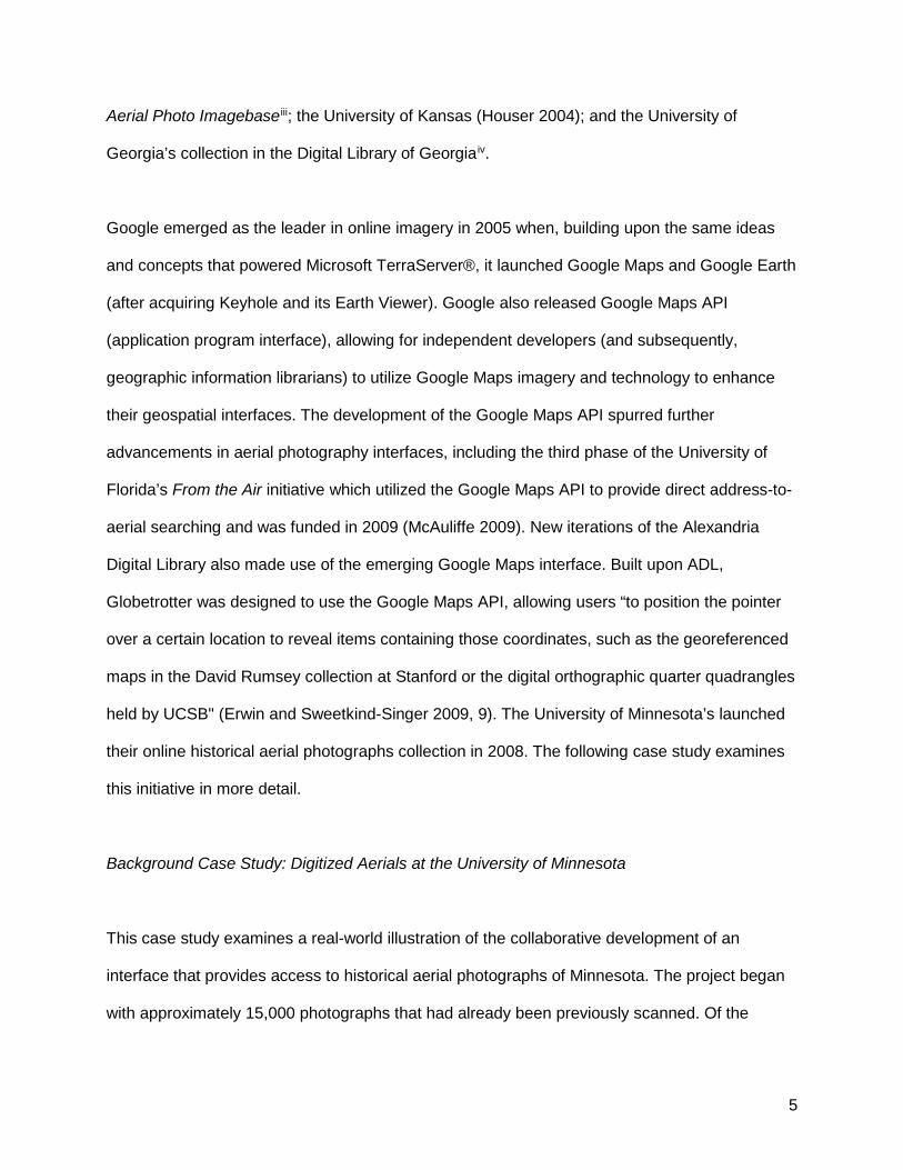
result was the initial incarnation of the Minnesota Historical Aerial Photographs Online (MHAPO)
page (see Figure 1). This method of delivering the collection materials to patrons was selected
for several reasons: speed, simplicity, and ease of use. Geolocating the photographs and
determining centerpoints is a fairly quick process once a student employee is shown how to do
so in ArcGIS. The initial result was relatively easy for most people to use as it utilized the
Google Maps interface—something with which a majority of internet users are familiar. The
original MHAPO site was launched in December 2008.
7
Once the interface was stable and loaded with 15,000 digitized aerial photographs, librarians
began the next phase of the project—to explore options for collaboration. The Minnesota
Department of Natural Resources (MN DNR) also maintained a database of digitized aerial
photographs and geolocated centerpoints. Many of the digitized photography sets were
scanned from the Map Library holdings. Photographs held by the MN DNR were scanned first,
and then the physical photographs were deposited with the Map Library. Due in large part to the
collaboration with regards to the physical photographs, it was possible to obtain a copy of the
shapefile for the geolocated centerpoints with links to the MNDNR digitized photographs. The
centerpoints were loaded into the MHAPO interface, resulting in a total of 74,000 that were then
available online for patron access.
Figure 1. Original MHAPO Interface
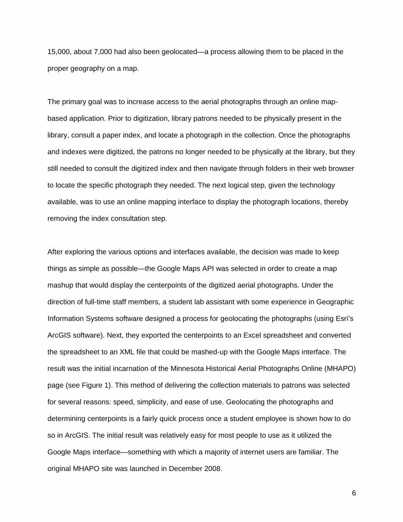
By early 2013, the MHAPO site had grown and was providing access to 113,000 digitized aerial
photographs. At this point, it was necessary to consider switching to another interface. While the
8
Google Maps API provided a familiar interface for users and automatic Google Maps
functionality, there were some drawbacks. First, it did not provide any indication of coverage
until the user had zoomed in quite close to their area of interest, which could result in users
spending quite a bit of time zooming in and out until they located an area with photographs
available. Second, loading a 113,000 line XML file often took quite a long time ‒ up to 15
seconds, even on a fast connection ‒ and this was a significant obstacle for some users. Third,
and most decisive, was that the Google Maps JavaScript API v.2 (in use at the time by the
interface) was set to be deprecated in November 2013. Due to the vast differences between v.2
and v.3 of the API, it would have been necessary to do a complete re-write of the code base for
the site. Given all of these factors, the collection managers made the decision to move to the
Esri JavaScript API (see Figure 2).
Figure 2. Redesigned MHAPO Interface
While the migration took quite a bit of time and JavaScript programming expertise, it was
ultimately successful, and the new version of MHAPO was well received by its users. Though
likely not due entirely to the redesign, the MHAPO website did see nearly a 70% increase in
9
weekly users from 2013 to 2015, with an average of over 800 users per week in 2015. The
MHAPO page currently provides online access to 121,000 aerial photographs – 97,000 from the
MNDNR and 24,000 from the Borchert Map Library.
Wanting to provide even more relevant aerial photograph services to the public, possible next
steps and evolutions of MHAPO were discussed. In conversations with the Center for Urban
and Regional Affairs at the University of Minnesota (CURA), a theme emerged ‒ researchers
needed to quickly and easily compare aerial photography from various decades, ideally without
in-depth knowledge of GIS software. Further discussion revealed the desire to compare pre-
interstate aerial photography to current configurations. To that end, Map Library began a pilot
project in which graduate research assistants georeferenced and stitched aerial photographs
from 1956 into a mosaic layer for Minneapolis and St. Paul. The mosaic was then loaded into
ArcGIS Server and visualized over currently satellite imagery in order to create a “swipe map”
application for historical aerial photograph comparisonv.
Further discussions with stakeholders revealed a desire to have the same “swipe” ability to
show the evolution of the suburban areas of the Twin Cities. In the interest of collaboration, and
to explore funding opportunities, the Map Library and CURA approached MetroGIS, a division of
the Metropolitan Council of the Twin Cities (a regional governance organization). A preliminary
agreement was struck, in which the Map Library would extend the pilot project to include an
historical aerial photograph layer from 1966 and negotiations would begin to receive funding
from MetroGIS to expand the project to include the entire seven-county Twin Cities metropolitan
area for both 1956 and 1966. Eventually, the funding was approved, and the expanded project
is currently underway. Given a successful outcome, there is hope of finding funding to increase
the reach of the project to include aerial mosaics from the 1970s and 1980s. Future plans for
10
this project also include allowing users to click on the historical imagery mosaic and download
individual aerial photographs.
As technology advances and is implemented, the focus needs to remain on the library materials,
digital or otherwise. In this case, digitized aerial photographs need to be described, archived,
and preserved in a way that will allow geographic information librarians to present them to the
public in the future.
Developments in Access and Discoverability for Online Collections
While online interfaces have become commonplace, technological advancements hold
tremendous opportunity for improving access to these collections. This section of the literature
review will look at current technology trends to improve access and discoverability. These
developments include automated georeferencing efforts, the use of crowdsourcing to
georeference photographs and enhance metadata, and the potential of the Semantic Web and
linked data to increase discoverability of collections.
When planning to create an online historical aerial photography collection, collection managers
have to weigh the benefits and costs of georeferencing their aerial photographs. In their 2004
project, the University of Kansas georectified part of their historical aerial photography collection
in ArcGIS using county digital orthophotographs as a reference layer (Houser 2004). While
traditional georeferencing provides unparalleled geographic access, it is also a painstaking,
labor intensive process and the cost becomes unmanageable when it must be done for large
collections of aerial photographs (Kim, Miller, and Bethel 2010). Because of this, other methods
of geotagging aerial photographs are often employed. Instead of georeferencing individual aerial
tiles, the University of Florida georeferenced the photomosaic indexes and assigned a single

11
point (upper right-hand corner) for each aerial tile on the index. Similarly, the University of
Colorado Boulder manually geolocated only the centerpoint for each photograph “because of
the significant time it would take to plot the bounding coordinates of each photograph, especially
given the poor condition of the historical prints” (Cronin, Lage, and Long 2005, 118). Other
institutions have extended the geolocation of their photographs by using ArcGIS to automate the
creation of bounding boxes for each photograph from known centerpoints (Christopher Thiry,
pers. communication October 3, 2014).
Researchers have worked to automate this time-consuming process while still maintaining a
satisfactory level of accuracy. Historical aerial photographs pose particular issues for automated
georeferencing. Two methods are referenced in this review. Nagarajan and Schenk (2016)
detail these limitations of working with historical aerial photography such as “missing flight
maps, poor radiometric quality, distortions due to sudden movements and inaccurate processing
of films” (16). Kim, Miller, and Bethel (2010), proposed using the Harris corner detection method
and ESRI’s ArcObjects software to automate the georeferencing of historical aerial
photography. Their article proposes the use of this algorithm to georeference a historical aerial
photograph against a digital orthophoto quadrangle of similar extent and resolution (Kim, Miller,
and Bethel 2010). They qualified the findings of their research by noting the accuracy of the
georeferencing was acceptable for “applications that do not require high accuracy or as an initial
approximation” (61). GeoMemoriesvi, a platform developed to provide online access to historical
aerial photographs of Italy, also utilized “image-processing and computer-vision techniques” to
improve workflow and decrease the amount of time and energy needed to make the collection
accessible (Abrate et al. 2013, 434). One of the goals of the project was “to advance the
automatization of the heavy tasks (georeferencing, mosaicking, etc.) involved in all projects of
this kind, by developing specifically tailored image-processing algorithms” to match dominant
features on images and filter out false matches (433).
12
While computer-generated analysis continues to be developed, some institutions have begun to
use crowdsourced geographic knowledge to connect cartographic materials to the physical
landscape. Jeff Howe coined the term “crowdsourcing” in a June 2006 Wired Magazine article
“The Rise of Crowdsourcing”. Crowdsourcing engages with users, allowing them to “achieve a
shared, usually significant, and large goal by working collaboratively together as a group”
(Holley 2010, 1). A parallel term, “volunteered geographic information (VGI)” was suggested by
Dr. Michael F. Goodchild in 2007 because it “emphasizes the role of volunteers, which brings
echoes of an earlier era during the Age of Discovery when geographic features were named by
individuals with no specific authority or qualifications” (Goodchild, Aubrecht, and Bhaduri 2016,
1). Goodchild has been a major voice in the paradigm change that occurred with the advent of
user-created web maps and mapping tools. (Sui, Elwood, and Goodchild 2013; Goodchild,
Aubrecht, and Bhaduri 2016). At the heart of this paradigm shift, is the opportunity to change an
entirely top-down model for information sharing and to include information being shared by
public volunteers upwards to the map makers and online mapping platforms.
In more recent years, specific projects have taken advantage of the opportunity crowdsourcing
provides. One high profile library project is the British Library’s use of crowdsourcing to
georeference their collections of antique maps (Kowal and Pridal 2012). Klokan Technologies
and the British Library worked together to develop a customized georeferencing tool. While the
results were not the same quality that would be obtained from “professional georeferencing” it
“satisfied the library's ultimate goal of obtaining bounding box-format spatial metadata for use in
search-and-discovery tools” (Kowal and Pridal 2012, 286). The New York Public Library (NYPL),
in particular, has also led a number of crowdsourcing projects for their map collections through
their innovation engine, NYPL Labs (Enis 2015). Ongoing projects involving cartographic
materials include NYPL Map Warper,vii a tool for browsing and rectifying historical maps from
13
the NYPL collections, and Building Inspector,viii a site collecting crowdsourced data about New
York City Sanborn Fire Insurance maps to enhance metadata and improve computer learning.
In 2016, Mooney et al. published what they believe to be the “first protocol for VGI vector data
collection” for crowdsourced geospatial data. While not tied to a particular VGI project, the
creation of protocol suggests future projects may be able to make more effective use of
crowdsourced data (Mooney et al. 2016). As crowdsourcing becomes more prevalent, best -
practices for its use are actively being developed.
While crowdsourcing data projects make use of the social Web, the Semantic Web takes a
different, more structured, approach. The Semantic Web “provides a common framework that
allows data to be shared and reused across application, enterprise, and community boundaries"
(Herman 2009, 1). The Semantic Web, a concept introduced by Tim Berners-Lee (1998), is a
model for publishing information on the World Wide Web in a format that allows for machine-
processing. The geospatial Semantic Web applies this concept to geospatial information or, as
explained by Zhang, Zhao, and Li (2015), the “Geospatial Semantic Web aims to add computer-
processable meaning (semantics) to the geospatial information on the World Wide Web” (37).
Linked data is an integral piece of the Semantic Web. Linked data refers to the way in which
data can be published online in a structured format so as to allow the data to be linked (Hart and
Dolbear 2013, 3). Developments in the Semantic Web and linked data are important for
librarians to stay informed about, in order to harness their potential for libraries.
Hart and Dolbear (2013) assert that “Linked data and the Semantic Web can help [geographic
information] become a more integrated part of the wider information community” (227). Bidney
and Clair (2014) wrote about potential benefits of the geospatial semantic web in their article
“Harnessing the Geospatial Semantic Web: Toward Place-Based Information Organization and

14
Access.” They discuss both the current use of linked data in catalogs of geospatial information
and explore ways that linked data and Semantic Web principles can improve access and
discovery of geospatial collections in the future. So far, the Semantic Web movement in libraries
has focused on building vocabulary and authority record files, “end-user services are not as
mature” (73). They argue that despite the constraints of long-held cataloging traditions and the
difficulties of keeping knowledge bases up-to-date, “libraries should begin to shift their thinking
toward utilizing linked data and the Semantic Web as these technologies are proving to be a
powerful tool for the future of information search and discovery” (76). By linking data,
geographic information librarians can promote sharing and use of information across
institutional lines.
Standards for Preservation
This article has discussed several technological efforts that have enhanced discoverability and
access to historical aerial photographs. In order for these developments to have a lasting
impact, geographic information librarians must also include digital preservation and the use of
standards, as part of historical aerial photograph collection projects.
One major undertaking in this area was the National Geospatial Digital Archive (NGDA)ix,
funded by the Library of Congress. The goal of the NGDA was to collect, preserve, and provide
long-term access to at-risk geospatial data (Erwin and Sweetkind-Singer 2009). This
collaborative project between the University of California, Santa Barbara and Stanford
University took a comprehensive view of long term geospatial data access and preservation.
Two parallel working repositories were created to best serve each institutions’ different
objectives and needs.
15
The lessons learned during the NGDA project provide crucial guidance to those seeking to
preserve digital collections. Specifically, Erwin and Sweetkind-Singer (2009) made a strong
case that “threat mitigation and context preservation are the key elements” to ensuring long-
term preservation (9). Threats to digital collections include changing data formats and archival
systems over time. To mitigate those threats they suggest a process employing a “relay model”
that focuses “both on curating the information over its (the archive’s) lifespan, and on facilitating
the handoff to the next archive system” (9). Other threat mitigation techniques included creating
“multiple copies that are decorrelated across as many threat vectors as possible" and
"redundant, reliable storage" (10). Preserving context can be much more complex, especially
when dealing with geospatial data. They cautioned that archives cannot “rely on an external
format registry to supply and preserve context; it must take on those tasks itself by archiving the
context along with the data" in some form of virtual container (10). Finally, if the library does not
have the resources for digital curation, they advocated for archive systems to “support a fallback
preservation mode" i.e. the "Doing Nothing" approach” (11). This fallback allows the data to be
preserved, as is, and with restricted access, until the resources and technology are in place to
provide sustainable access.
Deciding which format should be preserved represents “one of the important tasks associated
with preserving the millions of nationally important digital information resources that are in
danger of being lost or corrupted” (Hoebelheinrich 2012, 242). The Sustainability of Digital
Formats websitex, which is supported by the Library of Congress National Digital Information
Infrastructure and Preservation Program (NDIIPP), assists data curators in understanding “how
to analyze and to describe the sustainability of geospatial formats that they receive and
preserve” (242). To that end, the Sustainability of Digital Formats website provides “Format
Description Documents” with questions designed to clarify potential risks based on the
characteristics of file formats (261). It allows data curators to analyze any digital format in
16
context and to be “placed in relationship both to others in its content category and to similar
formats” (262).
One successful collaboration that addressed the need for preservation standards is the
Geospatial Multistate Archive and Preservation Partnership (GeoMAPPxi) project, which
provided “a toolkit for developing a geoarchiving business plan to establish, sustain, and extend
an archival program that advances the long-term preservation of a state's valuable geospatial
assets” (Bishop, Grubesic, and Prasertong 2013, 304). The GeoMAPP project arose from a
collaboration with the Library of Congress and state geospatial archive representatives from
North Carolina, Kentucky, Montana, and Utah. As the project grew to “well over a hundred local
agencies“, the “need for an infrastructure-based approach to archive development" became
clear (Morris, Tuttle, and Essic 2009, 518). By building the digital data infrastructure together,
geographic information librarians ensure lasting compatibility and communication between
systems.
As discussed in this literature review, there have been many advancements over the last two
decades in regards to aerial photography interface development, metadata enhancement, and
new recommendations for the preservation of digital cartographic materials. These past
practices have greatly informed the present state of aerial photography interfaces and, in turn,
allow geographic information librarians to prepare for new opportunities, which will be discussed
in the following section.
New Opportunities in Access: Connections and Collaboration
The last fifteen years have dramatically changed how users find and interact with library
historical aerial photography collections. The rise of searchable map interfaces make possible
17
new ways to index and search for these valuable resources. Geographic information librarians
must now look to the future to see what opportunities lie ahead. Some enhancements are fairly
well developed and just have not been applied to large aerial photography collections, others
still need to undergo significant development but present a promising future. What do managers
of aerial photography collections need to do to best position themselves for these new
opportunities? How can geographic information librarians work together to make these
technologies a reality?
The changes and advancement in access to aerial photography collections are clustered in
these, interconnected areas: interface development; metadata enhancement; increased
connections through linked data; and increased collaboration and partnerships. These areas are
the key to sustainable collections. This section will look specifically at how these areas of
opportunity could be applied to aerial photography collections.
Interface Development: Toward a Complete End-User Experience
It is essential to remember that one of the primary reasons that geographic information
librarians are concerned with concepts like enhanced metadata, the Semantic Web,
preservation standards, and strong collaborations, is because these developments allow
increased access to collections. The way these collections are accessed, the interface or
platform, then becomes an integral piece of the conversation. As information technology evolves
so must the technical systems that are used to access these rich digital resources.
One area of development, which is only just starting to be realized, is the application of
immersive geographic information visualization to aerial collection interfaces. In 2005, Google
Earth provided the ultimate geovisualization, enticing users to explore the world in an entirely

18
new way. The interactive, dynamic nature of the interface gave users seamless control over
their experience. Over 10 years later, digital curators and geographic information librarians are
only just beginning to see the development of immersive experiences that move beyond what
Google Earth provides. The terms “deep mapping”, “thick mapping”, and “hypercities” are also
used to describe rich and layered content that is deeply embedded with resources that provide
spatio-temporal and cultural context. Digital Humanists who have embraced geovisualization
are meaningful allies in developing multimedia platforms that allow new avenues for research,
evaluation, and exploration.
Scientists also have an interest in developing platforms that facilitate visualization and analysis.
One project, a “web-based multimedia spatial information system” was used to study the
distribution of mosquito-spread dengue fever through the southwestern U.S. and part of Mexico
(Moreno-Sanchez et al 2006, 715). The system created “a sensory-rich environment, one that
allows users to explore connections among data (maps, remotely sensed images, text, graphs,
360° panoramas and photographs), visualize information, formulate their own interpretations,
generate hypotheses and reach their own conclusions” (715). Systems like this one, which can
provide “better tools to analyze role-specific information, share and synthesize relevant
information, and remain aware of the activities of others”, are particularly critical for emergency
management personnel who rely on geospatial information and collaborative decision-making to
find quick solutions to life-threatening problems (Wu et al. 2013, 4). Both of these projects
allowed researchers to have access to deeper exploration of the content. New interfaces for
aerial photography collections could similarly be linked to historically and culturally significant
materials held in libraries with special collections.
When considering the end-user experience, it is also crucial for institutions to assess and
evaluate the usability of interfaces, especially as new technology is implemented. As ADL

19
continued to evolve, they employed user studies aimed at specific user groups to help direct
innovations that would improve user experience within the ADL interface (Hill et al. 2000). The
University of Colorado Boulder Libraries also utilized usability studies to evaluate the use of
their aerial photography interface with the goal of informing future design improvements (Long,
Lage, and Cronin, 2005). Usability studies of aerial photography interfaces are still not well-
represented in the literature and would provide great benefit in influencing future interface
enhancements.
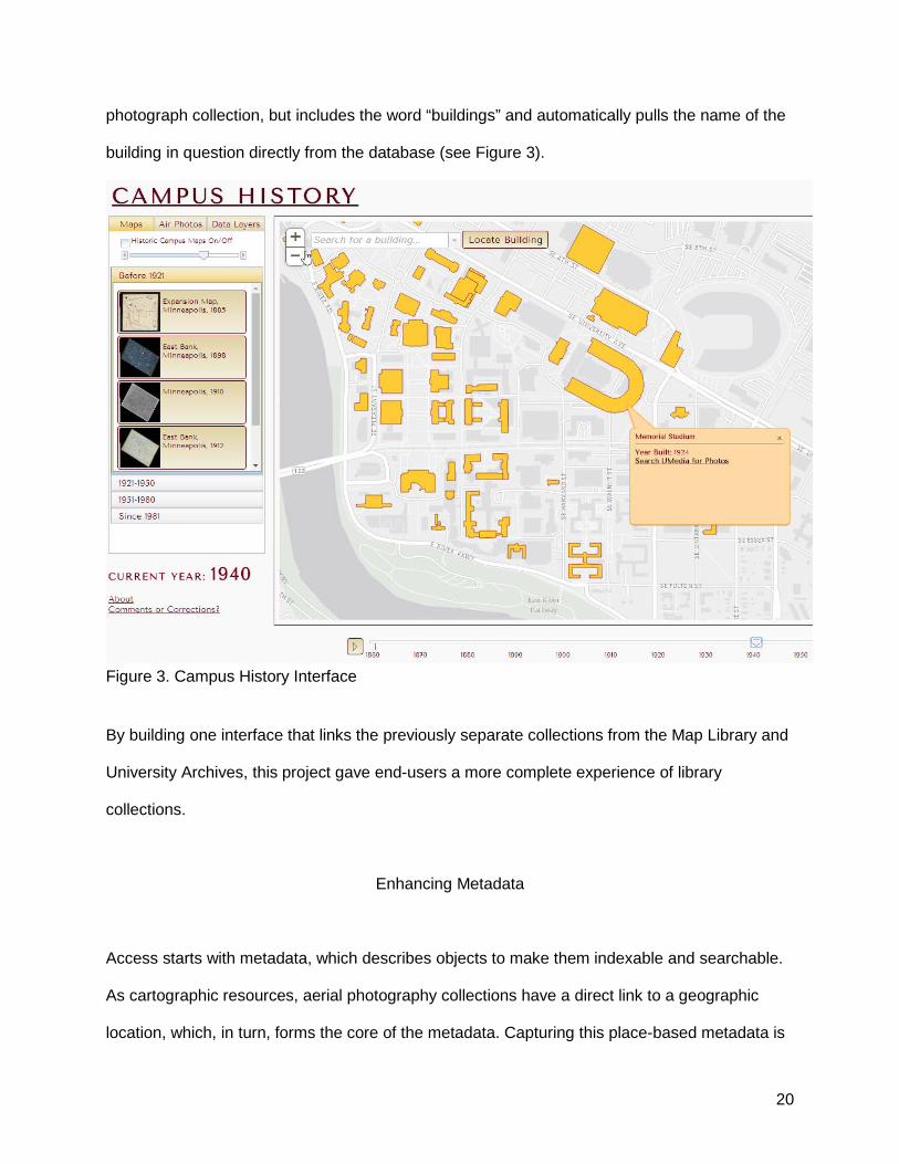
Case Study: Campus History at the University of Minnesota
This case study highlights one example of how to bring seemingly disparate collections together
in one searchable interface. In June 2013, the University of Minnesota launched a Campus
History web application that incorporated historical building footprints, digitized maps, and aerial
photographsxii. To further the end user experience, it was decided to link to historical building
photographs and oblique aerial photographs in the University Archives. At the time, only about
300 photographs had been digitized. A project was then undertaken to proactively digitize the
remainder of the historical building and aerial photographs held in the University Archives.
Between November 2013 and July 2015, nearly 5,900 photographs were digitized, including
appropriate metadata, and were ingested into the UMedia repositoryxiii. Since the metadata for
the photographs was entered after the creation of the geospatial database for historical building
footprints, staff were able to standardize the subject headings to ensure that they all included
the word “buildings” as well as the building name (or names, as some changed over time) as it
appeared in the database. That way, staff were able to build a dynamic search request into the
pop-up for the building in the web application that not only searches the University Archives
20
photograph collection, but includes the word “buildings” and automatically pulls the name of the
building in question directly from the database (see Figure 3).
Figure 3. Campus History Interface
By building one interface that links the previously separate collections from the Map Library and
University Archives, this project gave end-users a more complete experience of library
collections.
Enhancing Metadata
Access starts with metadata, which describes objects to make them indexable and searchable.
As cartographic resources, aerial photography collections have a direct link to a geographic
location, which, in turn, forms the core of the metadata. Capturing this place-based metadata is
21
key. This section discusses how geographic information librarians can enhance the metadata
associated with their aerial photography collections by collecting volunteered geographic
information using crowdsourcing techniques. Finally, it explores how librarians can use those
VGI data points to inform computer automation and can use crowdsourced labor to verify
automated georeferencing.
As mentioned in the literature review, crowdsourcing volunteered geographic information (VGI)
is set to change metadata generation radically. The highly detailed and local nature of aerial
photographs makes VGI a perfect way to gather information about a particular site. Aerial
photographs are filled with details often only known by local residents and, unlike maps, the
features (street names, coordinate systems, etc.) are not labeled. By using public knowledge
about local areas, there is the potential for the work of georeferencing aerial tiles to be spread
out among a large number of people. To do this, a platform to harvest crowdsourced data will
need to be developed for aerial photographs. Geographic information librarians can look for
models in the Building Inspectorxiv tool used by NYPL Labs and the Georeferencer tool used
both by David Rumsey’s websitexv and by the British Library.xvi The idea of enlisting public help
to classify landscapes and identify features on aerial photography is not far-fetched. In 2014,
Innovate UK funded the project Crowdsourcing Landscape Change as an attempt to apply
crowd-sourcing process to digital aerial photography. The project was tasked with developing an
online platform that “allows members of the public to look for landscape changes by comparing
pictures of the same sites from 2005 and 2013” (Carey 2015, 1). While its project goals were
promising, the results of the project remain unclear since the platform, Landscape Watch
Hampshire,xvii was not functional when checked in March 2017. Even without a currently
working website, the implementation of the project shows great promise for things to come.
22
Additionally, computer-driven automation is increasingly becoming possible. Using computer
vision and machine recognition of landforms and patterns on the landscape, the onus of
georeferencing individual tiles manually can be avoided. Experiments in computer learning are
currently being explored to see if computer vision can be improved using crowdsourced data. As
mentioned in the literature review, NYPL Labs’ Building Inspector is taking the crowdsourced
data being generated for the Sanborn maps and turning it into a computer learning tool.
Ultimately, with enough data, the computer should be able to replicate the decision-making
processes to create more valuable metadata for their Sanborn map collection. In partnership
with computer science and software experts, aerial photography collection managers can be on
the leading edge of this new technology and provide exciting new ways to access their
collections. There is an opportunity to build upon the Landscape Watch Hampshire platform for
crowdsourcing and add in a computer learning element to allow automation of feature
recognition and landscape types. This development would allow for new and improved search
interfaces, making it possible to search large photography collections for specific shapes and
patterns representing known landforms, buildings, and environmental landscapes.
Ultimately, a combination of techniques is required to produce the best results. Geographic
information librarians could start with indexes connected by a few points to a map interface. At
the same time, a new computer-generated algorithm could be used to create overlays. Both of
these techniques could be tested using an interface that allows users to zoom into local areas to
check and correct points overlaying on the landscape. As the computer learns from the
corrections, the algorithm is adjusted. The result could be aerials that are connected to the
landscape via many points and a system that checks for quality control along the way.
Using the Semantic Web and Linked Data
23
The developments discussed earlier in this article have facilitated advances in access and
discovery. In spite of these gains, most library online historical aerial photograph collections
exist as silos—providing access to individual collections or projects or, in some cases, too many
collections through a portal. The portal, however, still exists as a separated system. The
promise of the Semantic Web and linked data is to connect these isolated collections and other
types of geographic information on the web through machine-readable standards. As noted
earlier, to date this semantic layer is primarily made up of individual research projects (Bidney
and Clair 2014). These existing projects can inform the exploration of the geospatial Semantic
Web as it might apply to historical aerial photographs.
Geographic placename vocabularies, or ontologies, play an important role in the geospatial
Semantic Web. The largest dataset is Geonamesxviii. Geonames is an ontology with over eleven
million placenames worldwide. Each geographic name has a unique identifier so that the
dataset can be used to link information semantically via the web. There are many smaller
endeavors to develop specialized ontologies. Pelagios Commonsxix and the World War I Linked
Open Dataxx projects are two that focus on both creating and using historical placenames for the
Semantic Web. Pelagios Commons has numerous efforts regarding linked geospatial data in
the humanities. One interest group of relevance to aerial photographs focuses on gazetteers,
another on the modern world (post-1500 CE). The World War I Linked Open Data initiative
covers events, actors and places associated with World War I.
A recent, ongoing initiative, Linked Data for Production (LD4P),xxi is a particularly relevant
project because it is focused on the schema, tools, and data created and used by libraries.
Funded by the Mellon Foundation in 2014, LD4P is a collaboration of six academic libraries:
Columbia, Cornell, Harvard, the Library of Congress, Princeton, and Stanford. The initiative has

24
many components, driven by the individual institutions, including one focusing on cartographic
materials. Harvard leads this effort, which aims to extend the next-generation MARC standard
(called BIBFRAME) to describe cartographic resources and evaluate its effectiveness (Linked
Data for Production 2016). It will create a linked data description for cartographic materials and
tools and will document best practices. The practical component of this work will convert a
subset of OpenGeoMetadata xxiiixxii records in the FGDC metadata to linked data.
Geographic information librarians can use the principles of linked data and the tools developed
by the LD4P project and others, to expose their collections via the Semantic Web. For example,
the University of Colorado Boulder’s metadata includes a primary land feature for each
photograph, such as “Sugarloaf Mountain,” using terms from the Geographic Names Information
System.xxiv This metadata provided a more granular access point for historical aerial
photographs within the native interface. Transforming this placename data into linked data
would extend the metadata and connect the collection. Linked data has the potential to be
revolutionary, as it facilitates the machine-readable connection to any other related data and
resources.
Building a Sustainable Future through Collaborations
Providing pathways for collaboration is an essential role of the geographic information librarian
as digital curator and one that is impossible without serious thought to long-term sustainability,
formats, and standards. As geographic information librarians look toward the future of access to
online aerial photography collections, the long-term sustainability of these projects must be
taken into account. Their value is immense as is the work being put into them.
25
When approaching a collaborative aerial photography project, it is invaluable to take the
following questions into consideration. First, what are some strategies that can be used to
position institutions and collections for collaborations and large scale repositories? Second,
when thinking about sustainability, what are the threats to the data over time and how do
collection managers mitigate those threats? Finally, once collaborations are in place, how do
collection managers leverage those partnerships for future initiatives?
Whether or not an institution is currently engaged in a collaborative partnership, it is essential to
think of the future and how institutions can better position themselves and their collections for
collaborations. First, it is essential to have extensive knowledge of the materials and other
collections. Time and money spent creating inventories can provide significant dividends in
collaborative capital. It is also necessary to prioritize flexible structures and systems. When
investigating a platform for hosting digital content, it is crucial for metadata to both exportable
and importable into other databases. Similarly, it is advantageous to keep an eye towards
system integration. In order to allow systems from different institutions to communicate with
each other, institutions must use standards (referenced in previous sections) in both file types
and metadata.
Another, sometimes overlooked, need is to develop leadership competencies. Every project
needs leaders who can communicate effectively to provide clear vision and alignment. This is
especially necessary in collaborative projects that may involve multiple leaders. These leaders
must understand and agree on how decisions will be made during the life of the partnership.
Having someone in the primary leadership role, along with a project charter, will help to clarify
expectations. Within an institution, it is crucial for leaders to continually discuss and evaluate
collaboration opportunities. As with grant seeking, a culture of collaboration can be established
with a continual focus on its importance to the institution and the profession as a whole. All of
26
these activities pave the way for large-scale repositories, which hold the future for aerial
photography collections.
Digital preservation allows the data to have a future. Specific threats that need to be addressed
using preservation standards include: obsolete file formats; changing standards; the loss of
organizational/structural backbone (the data behind the data); virtual space limitations and
backup; methods of access evolving over time; and the cost of upkeep. Collaboration is key to
mitigating many of these threats. First of all, collaboration allows for the “redundant, reliable
storage” with the coordination of resources as suggest by Erwin and Sweetkind-Singer (2009,
9). It is also important to agree early on about the preservation of the item vs. the preservation
of the mode of access. When discussing the preservation of metadata with potential partners, it
must be carefully considered how to preserve the related files and organizational backbone of
the geospatial data (Erwin and Sweetkind-Singer 2009). One scanned aerial photograph tile
may have many associated files, especially if georeferenced. Keeping these files linked or in a
virtual container is part of the standards process that should be developed when starting a
collaboration. Finally, writing in longer term costs into proposals/grants for these potential
threats will allow general operations to be sustained beyond the project. These adaptable
systems are crucial so that when standards evolve over time changes can be made system-
wide.
out
Another part of building sustainable collections is establishing funding streams. Strategic
collaborations can provide avenues for additional funding and greater impact (McAuliffe 2013).
Grants and other funding opportunities often require, or explicitly express, a preference for
collaborative work. This can include other educational partners in K-12 education. McAuliffe
(2013) addresses how aerial photography collections, in particular, can serve K-12 educational
partners and the benefits those collaborations bring back to the collection. As an institution’s
27
network of collaborators expands, so does its reach and impact. New stakeholders are brought
into the institution’s sphere of influence and increased interest breeds necessary life into
collections. When a successful collaboration is expanded to include new partners, benefits for
all participants increase as well. Collaborative partnerships also provide valuable resources,
particularly in terms of labor, material collections, and funds. Collaboration with partner
institutions creates a network of support and shared workload for establishing data storage,
creating metadata, and developing new technologies.
Collaborative projects to create access to aerial photography collections online especially
benefit from partnerships with other institutions. One reason is that aerial photography
collections often drawn from similar sources for collection development. This source could be
the Aerial Photography Field Office (APFO) in Utah or regional, state, or local governmental
agencies. Large scale online repositories are one form of aerial photography collaborations.
Aerial photography collections also have common file format and metadata data needs. The
decision of which standards to use in an ever-evolving online environment can be complicated,
especially when dealing with geographically embedded resources such as aerial photography.
The Library of Congress’s Sustainability of Digital Formats websitexxv can be used to help
collection managers make decisions when faced with a variety of format choices
(Hoebelheinrich 2012). Geospatial metadata data standards for collaborative projects must also
be determined. While the past, present, and future of geospatial metadata standards are not
explored within the context of this article, it is critical to remember that their use plays a vital role
in allowing cross-communication between systems. The future cannot be predicted, but the
unknown can be prepared for by using widely adopted metadata standards for geospatial
materials. It is of particular importance to keep these metadata standards in mind when
attempting a planned collaborative project or when considering future opportunities. Because
28
resources are limited, cooperative and strategic decision-making should be used when
determining the standards and formats in which to invest time, money, and energy.
As mentioned above, collaboration and standards, and ultimately, sustainability are intimately
intertwined. They involve large communities of institutions to develop a system by which
collections can be shared and preserved. Standards are also necessary to make other
collaborative projects possible. When creating and curating digital collections, it is worthwhile to
design systems that support collaboration, engagement, education, and research. Collaborative
information sharing and visualization capabilities are rapidly becoming a vital part of the digital
toolkit for geographic information librarians.
Case Study: Minnesota Department of Natural Resources
This case study emphasizes the importance of collaboration between libraries and government
agencies in working to provide access to historical aerial photographs. Though the Borchert
Map Library at the University of Minnesota hosts the MHAPO interface for access to historical
aerial imagery and holds the archival collection of physical aerial photographs, the bulk of the
digitization efforts, as well as the hosting of the digitized imagery is done by the Minnesota
Department of Natural Resources (MN DNR). Currently, the MN DNR hosts over 92,000
photographs available through MHAPO. The Map Library adds access to an additional 29,000
photographs. Once the photographs are digitized, the physical copies are then sent to the Map
Library for archiving and preservation. This collaboration, developed over the past ten years,
has led to county offices and other state agencies (Department of Transportation and the
Pollution Control Agency, for example) partnering with the Map Library to archive and preserve
historical aerial photographs as they need to reduce office footprints or clear storage areas.
Without this collaboration, these unique historical documents would otherwise be lost.
29
By building a successful collaboration between the Map Library and the MN DNR, this project
gave end-users a more complete experience of the available aerial photograph collections and
paved the way for future work.
Conclusion: The Role of Geographic Information Librarians
Long-term sustainability of digital geospatial collections is a primary responsibility of geographic
information librarians. When addressing sustainability, it is important to look at how geographic
information librarians can position digital collections for future developments. Curation,
metadata, digital preservation, and collaboration all play an important part in sustainable
collections.
As stewards of the collections, it is important that geographic information librarians provide
leadership and direction for future initiatives. Included in the role of the geographic data librarian
is digital curation. Geographic information librarians who manage the online geospatial
information collections have a “lasting impact on the ways in which historical archives are
established and maintained” (Bishop, Grubesic, and Prasertong 2013, 298). Bishop, Grubesic,
and Prasertong (2013) maintain geographic information librarians hold a unique perspective
when it comes to collecting, maintaining, and preserving digital collections. While users are
focused on their immediate information needs, librarians are trained and have a professional
responsibility to “consider the actions taken to maintain and add value to geospatial data over its
lifecycle—well beyond their original purpose” (298). In particular, there are two essential roles of
the geographic information librarian when curating digital collections: 1) creating a sustainable
digital archive and 2) fostering engagement and future development through collaboration,
education, and further research.
30
Future research opportunities for geographic information librarians include an environmental
scan of aerial photograph collections available online and how access is provided and further
usability studies and user analysis of the interfaces providing access to aerial photograph
collections. Further investigation of the use of automated georeferencing for historical aerials, as
well as, tracking the development and implementation of the Semantic web and linked data will
also be essential.
As discussed throughout this article, new standards will be developed, new technologies will
evolve, and new opportunities will arise. The role of the geographic information librarian will
continue to require expertise or experience in the areas of metadata, digital preservation, and
collaboration. By adhering to these core principles, geographic information librarians will be well
positioned to repurpose collections for future uses.
References
Abrate, Matteo, Clara Bacciu, Anders Hast, Andrea Marchetti, Salvatore Minutoli, and Maurizio
Tesconi. 2013. "GeoMemories—A Platform for Visualizing Historical, Environmental and
Geospatial Changes in the Italian Landscape." ISPRS International Journal of Geo-Information
2(2): 432-455. doi:10.3390/ijgi2020432.
Barclay, Tom, Robert Eberl, Jim Gray, John Nordlinger, Guru Raghavendran, Don Slutz, Greg Smith
Phil Smoot, John Hoffman, Natt Robb III, Hedy Rossmeissl, Beth Duff, George Lee, Theresa
Mathesmier, Randall Sunne, Lee Ann Stivers, and Ken Goodman. 1998. "The Microsoft
TerraServer™.” Technical Report MSR-TR-98-17.
https://arxiv.org/ftp/cs/papers/9809/9809011.pdf.

31
Berners-Lee, Tim. 1998. “Semantic Web Roadmap.” Last modified October 14, 1998.
https://www.w3.org/DesignIssues/Semantic.html.
Bidney, Marcy, and Kevin Clair. 2014. "Harnessing the Geospatial Semantic Web: Toward Place-Based
Information Organization and Access." Cataloging & Classification Quarterly 52(1): 69-76.
doi:10.1080/01639374.2013.852038.
Bishop, Bradley Wade, Tony H. Grubesic, and Sonya Prasertong. 2013. “Digital Curation and the
GeoWeb: An Emerging Role for Geographic Information Librarians.” Journal of Map &
Geography Libraries 9(3):296-312. doi:10.1080/15420353.2013.817367.
Carey, George. 2015. “Council’s crowdsourcing site takes landscape monitoring online.” Digital By
Default News, September 2. http://www.digitalbydefaultnews.co.uk/2015/09/02/council-takes-
landscape-monitoring-online/ .
Cronin, Christopher, Kathryn Lage, and Holley Long. 2005. "The flight plan of a digital initiatives project:
Providing remote access to aerial photographs of Colorado." OCLC Systems & Services:
International digital library perspectives 21(2):114 -130. doi:10.1108/10650750510598710 .
Doneus, Michael, Martin Wieser, Geert Verhoeven, Wilfried Karel, Martin Fera, and Norbert Pfeifer.
2016. “Automated archiving of archaeological aerial images.” Remote Sensing, 8(3), 209.
doi:10.3390/rs8030209
Enis, Matt. 2015. “Wisdom of the crowd.” Library Journal, July 3.
http://lj.libraryjournal.com/2015/07/technology/wisdom-of-the-crowd-digital-collections/#.
Erwin, Tracey and Julie Sweetkind-Singer. 2009. “The National Geospatial Digital Archive: A
collaborative project to archive geospatial data.” Journal of Map & Geography Libraries, 6(1): 6-
25. doi:10.1080/15420350903432440.
Goodchild, Michael F. 2007. “Citizens as sensors: the world of volunteered geography.” GeoJournal,
69(4): 211–221. doi:10.1007/s10708-007-9111-y.
32
Goodchild, Michael. F., Christoph Aubrecht, and Budhendra Bhaduri. 2016. “New questions and a
changing focus in advanced VGI research.” Transactions in GIS. doi:10.1111/tgis.12242.
Haas, Stephanie C., Erich Kesse, Mark Sullivan, Randall Renner, and Joe Aufmuth. 2005. "From the
air: the photographic record of Florida's lands", OCLC Systems & Services: International digital
library perspectives 21(2):131-139.
Hart, Glen, and Catherine Dolbear. 2013. Linked Data: A Geographic Perspective. Boca Raton: CRC
Press.
Herman, Ivan. 2009. “W3C Semantic Web Frequently Asked Questions.” Last modified November 12,
2009. https://www.w3.org/2001/sw/SW-FAQ.
Hill, Linda L., Larry Carver, Mary Larsgaard, Ron Dolin, Terence R. Smith, James Frew, and Mary‐
Anna Rae. 2000. Alexandria digital library: User evaluation studies and system design. Journal
of the American Society for Information Science, 51(3), 246-259. doi:10.1002/(SICI)1097-
4571(2000)51:3<246::AID-ASI4>3.0.CO;2-6.
Hoebelheinrich, Nancy J. 2012 “An Aid to Analyzing the Sustainability of Commonly Used Geospatial
Formats: The Library of Congress Sustainability Website.” Journal of Map & Geography
Libraries 8(3):242-263. doi:10.1080/15420353.2012.700301.
Holley, Rose. 2010. “Crowdsourcing: How and Why Should Libraries Do It?.” D-Lib Magazine, 16(3/4).
doi:10.1045/march2010-holley.
Houser, Rhonda. 2004. “Georectification of Historic Aerial Photographs for Douglas County, Kansas
(poster).” Environmental Systems Research Institute. http://hdl.handle.net/1808/188.
Innovate UK. 2014. “Gateway to Research: Crowdsourcing Landscape Change.” Research Councils
UK. http://gtr.rcuk.ac.uk/projects?ref=101931.
Kim, Jae Sung, Christopher C. Miller, and James Bethel. 2010. “Automated Georeferencing of Historic
Aerial Photography.” Journal of Terrestrial Observation 2(1): 57-65.
33
Kowal, Kimberly. C. and Petr Pridal. 2012. “Online georeferencing for libraries: the British Library
implementation of Georeferencer for spatial metadata enhancement and public engagement.”
Journal of Map & Geography Libraries 8(3):276-289. doi:10.1080/15420353.2012.700914.
Larsgaard, Mary Lynette. 1998. Map Librarianship: An Introduction, Englewood, CO: Libraries
Unlimited.
Larsgaard, Mary Lynette and Larry Carver. 1995. “Accessing spatial data online: Project Alexandria”.
Information Technology and Libraries 14(2), 93-97.
Linked Data for Production (LD4P) (2015). Last modified February 20, 2017.
https://wiki.duraspace.org/pages/viewpage.action?pageId=74515029.
Linked Data for Production (LD4P) (2016). “Cartographic Extension.” Last modified March 14, 2016.
https://wiki.duraspace.org/display/LD4P/Cartographic+Extension.
Long, Holley, Kathryn Lage, and Christopher Cronin. 2005. "The flight plan of a digital initiatives project,
part 2: Usability testing in the context of user-centered design." OCLC Systems & Services:
International digital library perspectives 21(4):324-345. doi:10.1108/10650750510631703.
McAuliffe, Carol. 2009. "Phase III - From the Air: the photographic record of Florida's lands." Florida
Department of State, Division of Library and Information Services LSTA Application.
http://ufdcimages.uflib.ufl.edu/UF/90/00/00/14/00002/LSTA_Phase3_Aerials.pdf.
McAuliffe, Carol. 2013. “Geoliteracy through aerial photography: collaborating with K-12 educators to
teach the National Geography Standards.” Journal of Map and Geography Libraries, 9(3): 239-
258. doi:10.1080/15420353.2013.817368.
Mooney, Peter; Marco Minghini, Mari Laakso, Vyron Antoniou, Ana-Maria Olteanu-Raimond, and
Andriani Skopeliti. (2016.) “Towards a Protocol for the Collection of VGI Vector Data.” ISPRS
International Journal of Geo-Information 5(11) 217-240. doi:10.3390/ijgi5110217.
Moreno-Sanchez, Rafael, Mary Hayden, Craig Janes, and Geoffrey Anderson. 2006. “A web-based
multimedia spatial information system to document Aedes aegypti breeding sites and dengue
34
fever risk along the US-Mexico border.” Health & place 12(4):715-727.
doi:10.1016/j.healthplace.2005.10.001.
Morris, Steve, James Tuttle, and Jefferson Essic. 2009. “A Partnership Framework for Geospatial Data
Preservation in North Carolina.” Library Trends 57(3) :516-540. doi:10.1353/lib.0.0050.
Nagarajan, Sudhagar and Toni Schenk. 2016. “Feature-based registration of historical aerial images by
Area Minimization.” ISPRS Journal of Photogrammetry and Remote Sensing 116:15-23.
doi:10.1016/j.isprsjprs.2016.02.012.
Sui, Daniel, Sarah Elwood, and Michael Goodchild eds. 2013. Crowdsourcing Geographic Knowledge:
Volunteered Geographic Information (VGI) in Theory and Practice, Springer.
http://link.springer.com/book/10.1007/978-94-007-4587-2/page/1.
Thiry, Christopher J. J., ed. 2006. Guide to US Map Resources. Third Edition. Lanham, Md: Scarecrow
Press.
Wu, Anna, Gregorio Convertino, Craig Ganoe, John M. Carroll, and Xiaolong (Luke) Zhang. 2013.
"Supporting Collaborative Sense-Making in Emergency Management through Geo-
Visualization." International Journal of Human-Computer Studies 71(1): 4-23.
doi:10.1016/j.ijhcs.2012.07.007.
Wu, Chuanrong, Tian Zhao, and Weidong Li. 2015. Geospatial semantic web. Springer.
doi:10.1007/978-3-319-17801-1.
i http://ufdc.ufl.edu/l/aerials ii While the University of Colorado Boulder’s digital historical aerial photographs are still accessible in the digital library (https://www.cusys.edu/DigitalLibrary/aerials.html), the geographic interface in no longer online. iii http://images.library.illinois.edu/projects/aerial_photos/ iv http://dbs.galib.uga.edu/gaph/html/aboutproj.html v http://z.umn.edu/aerialswipe vi http://www.geomemories.org/ vii http://maps.nypl.org/warper/ viii http://buildinginspector.nypl.org/ ix http://www.ngda.org x http://www.digitalpreservation.gov/formats/ xi http://www.geomapp.net/ xii http://z.umn.edu/campushistory
35
xiii http://umedia.lib.umn.edu xiv http://buildinginspector.nypl.org/ xv http://www.davidrumsey.com/view/georeferencer xvi https://www.bl.uk/georeferencer/ xvii http://www.hampshire.landscapewatch.com/ xviii http://www.geonames.org/ xix http://commons.pelagios.org xx http://www.ldf.fi/dataset/ww1lod/ xxi https://wiki.duraspace.org/pages/viewpage.action?pageId=74515029 xxii https://github.com/OpenGeoMetadata/metadatarepository xxiii https://www.fgdc.gov/metadata/geospatial-metadata-standards xxiv https://geonames.usgs.gov/domestic/index.html xxv http://www.digitalpreservation.gov/formats/