this is a digital document from the collections of the...
TRANSCRIPT

This is a digital document from the collections of the Wyoming Water Resources Data System (WRDS) Library.
For additional information about this document and the document conversion process, please contact WRDS at [email protected] and include the phrase
“Digital Documents” in your subject heading.
To view other documents please visit the WRDS Library online at: http://library.wrds.uwyo.edu
Mailing Address: Water Resources Data System
University of Wyoming, Dept 3943 1000 E University Avenue
Laramie, WY 82071
Physical Address: Wyoming Hall, Room 249 University of Wyoming
Laramie, WY 82071
Phone: (307) 766-6651 Fax: (307) 766-3785
Funding for WRDS and the creation of this electronic document was provided by the Wyoming Water Development Commission
(http://wwdc.state.wy.us)

EXECUTIVE SUMMARY FREEDOM HILLS
IMPROVEMENT AND SERVICE DISTRICT
Gillette Regional Connections 2, Level II Study
August, 2013
Submitted To: Wyoming Water Development Commission 6920 Yellowtail Road Cheyenne, WY 82002 Prepared By: WLC Engineering, Surveying & Planning Weston Engineering, Inc. 200 Pronghorn Street 1401 Highway 16 E Casper, WY 82601 Upton, WY 82730

EXECUTIVE SUMMARY FREEDOM HILLS
IMPROVEMENT AND SERVICE DISTRICT
Gillette Regional Connections 2, Level II Study
August, 2013
Submitted To: Wyoming Water Development Commission 6920 Yellowtail Road Cheyenne, WY 82002 Prepared By: WLC Engineering, Surveying & Planning Weston Engineering, Inc. 200 Pronghorn Street 1401 Highway 16 E Casper, WY 82601 Upton, WY 82730 Principal Authors: Shane Porter, P.E. Ben Jordan, P.G.
GILLETTE REGIONAL CONNECTIONS 2 LEVEL II STUDY
EXECUTIVE SUMMARY
AUGUST, 2013
FREEDOM HILLS IMPROVEMENT AND SERVICE DISTRICT
PREPARED FOR:
WYOMING WATER DEVELOPMENT COMMISSION
PREPARED BY:
WLC ENGINEERING, SURVEYING AND PLANNING
IN CONJUNCTION WITH

Executive Summary
Page | 1
1. Introduction and Project Description
The Freedom Hills Improvement and Service District (ISD) owns and operates a rural water system located east of the corporate limits of Gillette, Wyoming and north of I-90. The Freedom Hills ISD contains 160 lots ranging in size from 2.48 Acres to 13.97 Acres. The original water system for the Freedom Hills ISD was permitted by the WDEQ in 1980 as permit number 80-382. In August, 2011 The City of Gillette applied to the WWDC for $60,000,000 to assist with funding for the District Extensions to the ongoing Regional Water System Project. The funding consists of a 67% ($40,000,000) grant from the WWDC with a 33% ($20,000,000) local match. The local match is planned to be provided from revenues received though a $20,000,000 Specific Purpose Excise Tax (Capital Facilities Tax) which was approved by the Campbell County Voters on May 3, 2011. In order to help determine District Connection priorities and further determine estimated costs for the District Extensions, Districts were encouraged to apply for a fully funded WWDC Level II study to perform a more detailed evaluation of a possible regional connection as well as to help identify other possible deficiencies within their water systems. In June of 2012, WLC Engineering, Surveying and Planning (WLC) was hired by the WWDC to complete this Level II study. The main concerns of the Freedom Hills water system are low pressure sevice lines, unknown location, condition and remaining life of main lines, a lack of back-up supply, lack of mainline valving, and water quality concerns with slightly elevated Fluoride concentrations. Since 2008, two annual samples have been reported with Fluoride levels ranging from 2.5 mg/l to 2.8 mg/l, which is less than the Maximum Contaminant Level (MCL) of 4 mg/l, but exceeds the secondary contaminant level of 2.0 mg/l. These levels of Fluoride can cause tooth issues in children. The primary focus of this study was to evaluate options for a regional connection and provide recommendations and costs (capital and operating) for connecting to the regional system. In addition, WLC evaluated the functionality of the Freedom Hills ISD water system as a whole. It was the goal of this Level II Study to develop a plan that will guide the Freedom Hills ISD with funding and options to maintain a reliable water system into the future.
2. Water Usage
To determine current water use, water meter readings were obtained from the system operator, the Water Guy (Duaine Faucett), for the Freedom Hill ISD over a three year period from January 2009 to December 2011. The records contained the monthly usage figures for the master water meter located in the pump house. The records were entered into a database in order to allow for demand calculations for the model. The Freedom Hills water system operates as one zone which is pressurized via the head elevation of the tank and a 7.5 HP booster pump located in the pump house. The booster pump serves to provide required pressures for the highest lots located adjacent to the tank parcel. Figure 2.1 presents the overall water system identifying the lots served by the Freedom Hills ISD. From the monthly water usage reports provided by the operator, a total water usage was calculated for each year and the three corresponding amounts were averaged to create an average year demand in gallons. Table 2.1 presents the total year demands for 2009, 2010 and 2011, and the average year demand.
Executive Summary
Page | 2
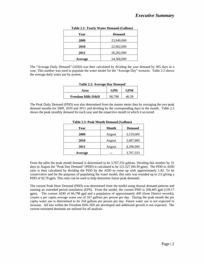
Table 2.1: Yearly Water Demand (Gallons)
Year Demand
2009 23,940,000
2010 22,962,000
2011 26,202,000
Average 24,368,000 The “Average Daily Demand” (ADD) was then calculated by dividing the year demand by 365 days in a year. This number was used to populate the water model for the “Average Day” scenario. Table 2.2 shows the average daily water use by system.
Table 2.2: Average Day Demand
Area GPD GPM
Freedom Hills IS&D 66,798 46.39 The Peak Daily Demand (PDD) was also determined from the master meter data by averaging the two peak demand months for 2009, 2010 and 2011 and dividing by the corresponding days in the month. Table 2.3 shows the peak monthly demand for each year and the respective month in which it occurred.
Table 2.3: Peak Month Demand (Gallons)
Year Month Demand
2009 August 3,519,000
2010 August 3,487,000
2011 August 4,296,000
Average -- 3,767,333
From the table the peak month demand is determined to be 3,767,333 gallons. Dividing this number by 31 days in August the “Peak Day Demand” (PDD) is calculated to be 121,527 (84.39 gpm). The PDD to ADD ratio is then calculated by dividing the PDD by the ADD to come up with approximately 1.82. To be conservative and for the purposes of populating the water model, this ratio was rounded up to 2.0 giving a PDD of 92.78 gpm. This ratio can be used to help determine future peak demands. The current Peak Hour Demand (PHD) was determined from the model using diurnal demand patterns and running an extended period simulation (EPS). From the model, the current PHD is 200,405 gpd (139.17 gpm). The current ADD of 66,798 gpd and a population of approximately 400 (from District records), creates a per capita average water use of 167 gallons per person per day. During the peak month the per capita water use is determined to be 334 gallons per person per day. Future water use is not expected to increase. All lots within the Freedom Hills ISD are developed and additional growth is not expected. The current estimated demands are utilized for all analysis.


Executive Summary
Page | 4
3. Hydraulic Analysis
The layout for the current water system was determined using a combination of existing plans from the original installation, collected field survey data, and information from the system operator. This information was compiled and a layout was developed within the Bentley WaterCAD V8i modeling software. The analysis of the Freedom Hills water distribution system shows that the system is adequately sized to provide necessary flows and pressures for the current demands required. Water age throughout the system is observed to be good as there are no areas of high retention time which would reduce the chlorine residual in the water.
4. Geographic Information System (GIS) Development
The following components are included in the GIS database to provide the Freedpm Hills ISD with a solid base of geospatial data for their water system and to provide a platform to further develop the GIS database in other areas of critical infrastructure management. The components included in the GIS database include:
1. Geodatabase – A geodatabase is a database specifically designed to support the collection, maintenance, analysis and visualization of spatial data. The geodatabase developed for this project was designed to store water system features and to support the implementation of recommended water system improvements identified in the Level II Study document.
2. Aerial Photography – high spatial and temporal accuracy aerial imagery provides a consistent
backdrop for the production of mapping products as well as serving as a valuable resource for further spatial data development. Aerial imagery was obtained from the City of Gillette for the study area.
5. Water System Operations
The Freedom Hills Improvement District currently gets its raw water from two groundwater supply wells; Freedom Hills #1 which is located near the storage tank and treatment building off Mallard Drive, and Freedom Hills #2 which is located northwest of the storage tank off Meadowlark Road. Freedom Hills #1 was drilled in 1981 to a depth of 1,560’ with the pump set at 920’, while Freedom Hills #2 was drilled in 1982 to a depth of 1,254’. The combined pumping rate of the two wells is approximately 200 gpm. While on-site, WLC and WESTON staff observed a combined pumping rate of 191 gpm. When Freedom Hills #1 was turned off, the pumping rate was 88 gpm. Therefore, the pumping rate of Freedom Hills #1 was observed to be 103 gpm, and the pumping rate of Freedom Hills #2 was observed to be 88 gpm. The raw water from Freedom Hills #1 and Freedom Hills #2 has been found to have slightly elevated Fluoride concentrations. A detailed analysis of the existing water supply is included in Section 6 of this study. A chlorine gas disinfecting system is used to treat the raw water prior to entering the storage tank. The chlorination system is controlled by the well pumps turning on and off. When the wells turn on, a solenoid valve is energized allowing chlorine gas to be injected in the water supply. The chlorine gas is located in a separate room of the pump house. The chlorine is applied at a target dosage of 0.5 ppm and the residual is measured directly out of the tank using a HACH Colorimeter. Treated water is pumped into the storage tank by the well pumps. The bolted steel tank was put into service in 1981. It is a ground level 21’ diameter bolted steel tank with a base elevation of 4597.50 ft and a height of 28’. The tank provides a total capacity of 75,000 gallons. The low level ‘pump on’ elevation is 4620.50, which is a 23’ water column. The tank is reportedly in good condition with minimal leaks or deterioration. The storage tank is able to provide adequate storage to meet the ADD of 66,798 gallons. The tank has the capacity to provide water for approximately one day at the average summer day demand and two days at the average winter day demand should the water supply be disconnected. The tank can not feasibly be taken out of service for cleaning or coating due to the lack of contact time for chlorine in the distribution

Executive Summary
Page | 5
system alone. A back-up connection to regional water would allow the tank to be taken out of service for an extended period of time for maintenance. Water from the tank is distributed to the system via a booster pump located in the pump house adjacent to the tank. The booster pump configuration consists of a single 7.5 hp pump. The system is capable of delivering the required demands to the district at pressures ranging from 40 to 110 psi. No back-up power supply is in place for this system. In the event of power loss all users will experience reduced pressures especially those near the tank as the system will rely on only the head pressure from the tank water level, until power is restored. WLC has determined that the distribution piping consists of approximately 15,570 lineal feet of 6” Perma-Strand Pipe installed in the early 1980’s. Fortunately, the Freedom Hills operator has reported no breaks since he began operating the system in 1999, and has not had to expose the main line at all. Branching from the main are several small distribution mains. These mains are estimated to be 2” diameter based on repairs that have been made by the systems operator. These mains consist of a low pressure polyethylene material that frequently breaks due to line pressures in these areas exceeding 100 psi. Additional PRV’s should be installed in the system to reduce line pressures in an effort to minimize line ruptures. Individual services are tapped on the 6” and 2” distribution mains. These services are believed to be all ¾” polyethylene piping based on operator records. None of the individual services are metered. Water meters will be required by the various funding agencies to ensure conservation and the ability to track water usage and system loss. Meters and backflow preventers should be installed on all the individual service connections. New curbstops should also be installed upstream of the meter pits. The distribution system is lacking main line valves that would allow better isolation of sections during repairs. The operator is only aware of three (3) mainline valves on the 6” distribution system. It may be that other valves are present, but are buried below grade. Several new 6” isolation valves should be cut in on the 6” main line throughout the system to allow isolation of sections to occur.
6. Water Supply Analysis
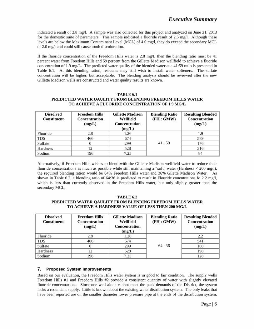
The Freedom Hills ISD is currently supplied by the supply wells Freedom Hills #1 and Freedom Hills #2 which both produce water from the Fort Union Formation. Freedom Hills #1 Freedom Hills #1 is currently equipped to produce approximately 103 gpm and serves as approximately 54% of the water supply for the Freedom Hills ISD. Water level data for Freedom Hills #1 is limited which prevents a detailed analysis. A water level measurement was taken by the system operator on December 13, 2011 at 530 feet below ground level. A water level measurement was taken by WESTON staff on April 12, 2013. The water level reading at that time was 645 feet below ground level. Based on the limited data, it appears that water level elevations are higher than when the well was first drilled, which was recorded to be 650 feet below ground level. Freedom Hills #2 Freedom Hills #2 is currently equipped to produce approximately 88 gpm and serves as approximately 46% of the water supply for the Freedom Hills ISD. Water level data for Freedom Hills #2 is limited which prevents a detailed analysis. A water level measurement was taken by the system operator on December 13, 2011 at 587 feet below ground level. A water level measurement was taken by WESTON staff on April 12, 2013. The water level reading at that time was 633 feet below ground level. Based on the limited data, it appears that water level elevations are similar to when the well was first drilled, which was recorded to be 600 feet below ground. Limited water quality data is available for Freedom Hills #1 and Freedom Hills #2. The only available data was the 2011 Consumer Confidence Report, and a few samples provided by the system operator. Water quality samples are combined samples of the water supply, and not specific to Freedom Hills #1. A fluoride sample collected May 6, 2008 indicated a result of 2.5 mg/l and a sample from March 21, 2013
Executive Summary
Page | 6
indicated a result of 2.8 mg/l. A sample was also collected for this project and analyzed on June 21, 2013 for the domestic suite of parameters. This sample indicated a fluoride result of 2.5 mg/l. Although these levels are below the Maximum Contaminant Level (MCL) of 4.0 mg/l, they do exceed the secondary MCL of 2.0 mg/l and could still cause tooth discoloration. If the fluoride concentration of the Freedom Hills water is 2.8 mg/L then the blending ratio must be 41 percent water from Freedom Hills and 59 percent from the Gillette Madison wellfield to achieve a fluoride concentration of 1.9 mg/L. The predicted water quality of the blended water at a 41:59 ratio is presented in Table 6.1. At this blending ration, residents may still wish to install water softeners. The sulfate concentration will be higher, but acceptable. The blending analysis should be reviewed after the new Gillette Madison wells are constructed and water quality results are known.
TABLE 6.1
PREDICTED WATER QAULITY FROM BLENDING FREEDOM HILLS WATER TO ACHIEVE A FLUORIDE CONCENTRATION OF 1.9 MG/L
Dissolved
Constituent Freedom Hills Concentration
(mg/L)
Gillette Madison Wellfield
Concentration (mg/L)
Blending Ratio (FH : GMW)
Resulting Blended Concentration
(mg/L)
Fluoride 2.8 1.26
41 : 59
1.9 TDS 466 674 589 Sulfate 0 299 176 Hardness 12 528 316 Sodium 196 7.25 84 Alternatively, if Freedom Hills wishes to blend with the Gillette Madison wellfield water to reduce their flouride concentrations as much as possible while still maintaining a “soft” water (Hardness < 200 mg/l), the required blending ration would be 64% Freedom Hills water and 36% Gilette Madison Water. As shown in Table 6.2, a blending ratio of 64:36 is predicted to result in Flouride conentrations fo 2.2 mg/l, which is less than currently observed in the Freedom Hills water, but only slighly greater than the secondary MCL.
TABLE 6.2 PREDICTED WATER QAULITY FROM BLENDING FREEDOM HILLS WATER
TO ACHIEVE A HARDNESS VALUE OF LESS THEN 200 MG/L
Dissolved Constituent
Freedom Hills Concentration
(mg/L)
Gillette Madison Wellfield
Concentration (mg/L)
Blending Ratio (FH : GMW)
Resulting Blended Concentration
(mg/L)
Fluoride 2.8 1.26
64 : 36
2.2 TDS 466 674 541 Sulfate 0 299 108 Hardness 12 528 198 Sodium 196 7.25 128
7. Proposed System Improvements
Based on our evaluation, the Freedom Hills water system is in good to fair condition. The supply wells Freedom Hills #1 and Freedom Hills #2 provide a consistent quantity of water with slightly elevated fluoride concentrations. Since one well alone cannot meet the peak demands of the District, the system lacks a redundant supply. Little is known about the existing water distribution system. The only leaks that have been reported are on the smaller diameter lower pressure pipe at the ends of the distribution system.
Executive Summary
Page | 7
These breaks are attributed to high line pressures (greater than 100 psi) at the lower elevations of the District. Pressure reducing valves should be installed at various locations in the system to reduce the likelihood of leaks in the smaller diameter distribution lines. When line breaks do occur, the operator has limited ability to isolate areas due to the lack of mainline valves. New valves should be installed to allow better operation of the system. The lack of water meters is also a deficiency in the system. Water meters should be installed on all individual services to assist with water conservation and equitable cost distribution to the systems users. Many funding sources will require the installation of meters before considering funding for major improvements. The following Alternatives have been considered to address the Freedom Hills ISD current deficiencies.
Alternative Description
1 Connect to the Gillette Regional Water System and Discontinue use of the Existing Wells
2 Connect to the Gillette Regional Water System and Blend with Water from Freedom Hills #1 and #2.
3 Install Water Meters, PRV’s and Mainline Valves
4 Connect to the Gillette Regional Water System, upgrade existing distribution system with pipe sizes and requirements meeting City standards.
5 Do Nothing
7.1 Alternative 1 - Connect to the Gillette Regional Water System as a Wholesale Water Customer and Discontinue Use of the Existing Wells
At this time and based on water level and water quality data for Freedom Hills #1 and #2, it is not believed that Freedom Hills will be facing an emergency situation in the near future. This alternative is being presented to evaluate cost comparisons to operate the existing wells versus purchasing wholesale water from the Regional system. This will assist the District in making decisions related to well replacement as the life cycle of the existing wells approaches. Alternative 1 assumes a direct connection to both the existing 30” Madison Transmission Main as well as the proposed new 42” Madison Transmission Main located along Highway 51 south of I-90 at Moran Ranch Road. The dual connection will allow flexibility in operation of the regional system and allow either of the lines to be out of service while still providing a water supply. From the connection point, a main line extension will be required to extend water north across I-90 to the District. This extension is referred to as Meadow Springs Line 1. The Meadow Springs Line 1 and the connection to Freedom Hills will require the installation of approximately 7,200 feet of 12” PVC water main and 50 feet of 4” PVC, numerous fittings and several road bores. An above ground precast concrete meter/control building would be installed south of the Freedom Hills Tank. This building would contain a water meter, a reduced pressure backflow preventer, an emergency bypass, a pressure reducing valve and SCADA equipment. Approximately 60 feet of 4” main will be required from the meter building to the connection point at the existing pump house building. The piping from the meter building to the connection at the existing distribution piping would be owned and operated by the Freedom Hills ISD.
7.2 Alternative 2 - Connect to the Gillette Regional Water System as a Wholesale Water Customer and Blend with Water from Southfork #1
Alternative 2 proposes using a regional connection to supplement and blend with water from wells Freedom Hills #1 and #2. This blending would provide a means to reduce fluoride levels to below the secondary standard of 2.0 mg/l. Freedom Hills ISD would become a wholesale costumer for the water

Executive Summary
Page | 8
purchased for blending. A blending ratio of 59% Regional Madison water and 41% Freedom Hills water would be required to reduce the Freedom Hills fluoride levels to just below the secondary MCL. This ratio is based on water quality from the existing Madison Wellfield and initial water quality from the two new Madison Test Wells. This ratio also assumes a water quality of 2.8 mg/l in the Freedom Hills water supply which is the highest measured concentration. Another option for the District is to blend with a lower ratio of Madison water and a higher ratio of Freedom Hills water to reduce Flourides as much as possible while keeping the Hardness value less than 200 mg/l. For either blending alternative, routine monitoring of fluoride and hardness concentrations will be required and blending adjusted accordingly. Alternative 2 will require the same regional components as Alternative 1. The Gillette Regional Water System would own and maintain all piping and appurtenances up to and including the meter building and all appurtenances inside. From a point just outside and downstream of the meter building, the Freedom Hills ISD would assume ownership and maintenance responsibilities. For Alternative 2, a blending valve vault would be installed just downstream of the meter building. The blending valve vault would consist of 4” piping from the meter building and 4” piping from each of the Freedom Hills wells. A manual control valve would be installed on each line, and a blending valve would be installed on the line from the regional connection. The blending valve would reduce the pressure of the regional supply equal to that of the Freedom Hills supply so that the control valves could distribute from the desired percentages of each supply source. Analyzers or colorimeters would need to be installed in the blending vault on both supply lines as well as the blended line. The analyzers would need to monitor Hardness as well as Flouride. These analyzers would allow the operator to adjsut the blending valves accordingly to achieve the desired blended concentrations. The automatic analyzers would not be elegible for WWDC funding as they are considered to be related to treatment. The increased monitoring and will result in increased operator costs. For Alternative 2, the Freedom Hills ISD would become a wholesale City of Gillette customer. Freedom Hills ISD would continue to provide retail service to its customers, and would maintain ownership responsibilities of its distribution system. Chlorination of the blended water would be necessary to ensure a chlorine residual in the blended supply water.
7.3 Alternative 3 – Install Water Meters, PRV’s and Mainline Valves
Alternative 3 consists of the installation of water meters at each of the 160 individual water service locations, installation of Pressure Reducing Valves at specific locations throughout the District, and installing mainline valves throughout the 6” system for better isolation. As discussed in Section 5, none of the individual water services are metered. Installation of water meters will allow a means of equitable water service billing to each property owner, as well as provide a means to implement tiered water rates to promote water conservation. Water conservation will reduce water consumed and reduce the amount of water purchased from the Regional Water System if a connection is made. In addition, funding sources will likely require water meters to be installed before recommending funding for any other significant improvements. Cost estimates for the Alternatives 1, 2 and 3 are presented in Table 7.1 below.
IMPROVEMENT TOTAL COSTREGIONAL SYSTEM PORTION
TOTAL COSTSOUTHFORK ESTATES ISD
PORTION TOTAL COST
REGIONAL CONNECTION ALTERNATIVE 1 $1,396,800 $1,373,895 $22,905
REGIONAL CONNECTION ALTERNATIVE 2 $1,535,234 $1,373,895 $161,339
ALTERNATIVE 3 $818,973 $0 $818,973
TABLE 7.1 COST ESTIMATES FOR ALTERNATIVES 1, 2 and 3
Executive Summary
Page | 9
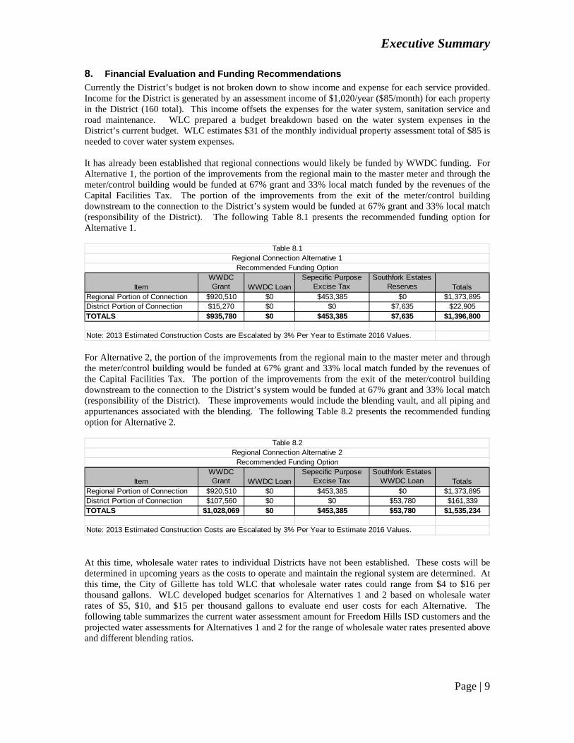
8. Financial Evaluation and Funding Recommendations
Currently the District’s budget is not broken down to show income and expense for each service provided. Income for the District is generated by an assessment income of $1,020/year ($85/month) for each property in the District (160 total). This income offsets the expenses for the water system, sanitation service and road maintenance. WLC prepared a budget breakdown based on the water system expenses in the District’s current budget. WLC estimates $31 of the monthly individual property assessment total of $85 is needed to cover water system expenses. It has already been established that regional connections would likely be funded by WWDC funding. For Alternative 1, the portion of the improvements from the regional main to the master meter and through the meter/control building would be funded at 67% grant and 33% local match funded by the revenues of the Capital Facilities Tax. The portion of the improvements from the exit of the meter/control building downstream to the connection to the District’s system would be funded at 67% grant and 33% local match (responsibility of the District). The following Table 8.1 presents the recommended funding option for Alternative 1.
ItemWWDC Grant WWDC Loan
Sepecific Purpose Excise Tax
Southfork Estates Reserves Totals
Regional Portion of Connection $920,510 $0 $453,385 $0 $1,373,895District Portion of Connection $15,270 $0 $0 $7,635 $22,905TOTALS $935,780 $0 $453,385 $7,635 $1,396,800
Note: 2013 Estimated Construction Costs are Escalated by 3% Per Year to Estimate 2016 Values.
Table 8.1Regional Connection Alternative 1
Recommended Funding Option
For Alternative 2, the portion of the improvements from the regional main to the master meter and through the meter/control building would be funded at 67% grant and 33% local match funded by the revenues of the Capital Facilities Tax. The portion of the improvements from the exit of the meter/control building downstream to the connection to the District’s system would be funded at 67% grant and 33% local match (responsibility of the District). These improvements would include the blending vault, and all piping and appurtenances associated with the blending. The following Table 8.2 presents the recommended funding option for Alternative 2.
ItemWWDC Grant WWDC Loan
Sepecific Purpose Excise Tax
Southfork Estates WWDC Loan Totals
Regional Portion of Connection $920,510 $0 $453,385 $0 $1,373,895District Portion of Connection $107,560 $0 $0 $53,780 $161,339TOTALS $1,028,069 $0 $453,385 $53,780 $1,535,234
Note: 2013 Estimated Construction Costs are Escalated by 3% Per Year to Estimate 2016 Values.
Table 8.2Regional Connection Alternative 2
Recommended Funding Option
At this time, wholesale water rates to individual Districts have not been established. These costs will be determined in upcoming years as the costs to operate and maintain the regional system are determined. At this time, the City of Gillette has told WLC that wholesale water rates could range from $4 to $16 per thousand gallons. WLC developed budget scenarios for Alternatives 1 and 2 based on wholesale water rates of $5, $10, and $15 per thousand gallons to evaluate end user costs for each Alternative. The following table summarizes the current water assessment amount for Freedom Hills ISD customers and the projected water assessments for Alternatives 1 and 2 for the range of wholesale water rates presented above and different blending ratios.

Executive Summary
Page | 10
Current Monthly Assessment Applied to Water Rates $23.00
Projected Assessment for Regional Connection Alternate 1 (Use 100% Regional Water at $5/Thousand Gallons)
$85/month for Water $139/month Total
Projected Assessment for Regional Connection Alternate 1 (Use 100% Regional Water at $10/Thousand Gallons)
$149/month for Water $203/month Total
Projected Assessment for Regional Connection Alternate 1 (Use 100% Regional Water at $15/Thousand Gallons)
$212/month for Water $266/month Total
.Projected Water Rates for Regional Connection Alternate 2 (Use 59% Regional Water at $5/Thousand Gallons)
$76/month for Water $130/month Total
Projected Water Rates for Regional Connection Alternate 2 (Use 59% Regional Water at $10/Thousand Gallons)
$110/month for Water $164/month Total
Projected Water Rates for Regional Connection Alternate 2 (Use 59% Regional Water at $15/Thousand Gallons)
$151/month for Water $205/month Total
Projected Water Rates for Regional Connection Alternate 2 (Use 36% Regional Water at $5/Thousand Gallons)
$62/month for Water $116/month Total
Projected Water Rates for Regional Connection Alternate 2 (Use 36% Regional Water at $10/Thousand Gallons)
$85/month for Water $139/month Total
Projected Water Rates for Regional Connection Alternate 2 (Use 36% Regional Water at $15/Thousand Gallons)
$107/month for Water $161/month Total
Table 8.3Summary of Current and Projected Water Rates
for Regional Connection Alternatives 1 and 2
9. Conclusions and Recommendations
The Freedom Hills water system is in good condition and provides a reliable source of water to its customers. The system’s main deficiencies at this time are slightly elevated fluoride concentrations, lack of individual meters, high pressures at the lower elevations, and the lack of sufficient main line valves. Several alternatives were investigated in this study to mitigate these deficiencies. Alternative 2, blending Regional water with the water from Freedom Hills #1 and #2 wells at a 59:41 (Regional:Freedom Hills) ratio is expected to reduce fluoride concentrations to below the secondary MCL of 2.0 mg/l. Blending at this ratio however will result in hardness values of around 316 mg/l as CaCO3. At this value, water softeners will likely be desired by the District’s customers. The blending ratio is based on projected pumping rates along with recent water quality data from the new Madison Wells and will require further analysis once the wells are all completed and water quality and quantity results are available. Blending at this ratio results in a significant wholesale purchase of Regional water. This purchase will result in significant increased assessment amounts to the District residents. The eventual wholesale cost of Regional water is yet to be established. The wholesale cost will way heavy on the decision to connection to the Regional system. A reduced blending ratio of 36:64 (Regional:Freedom Hills) will reduce fluoride levels slightly to approximately 2.2 mg/l from 2.8 mg/l, and is estimated to maintian hardness belwo 200 mg/l. This reduced blending ratio would substantially reduce the wholesale purchase of water from the Regional system. WLC recommends that the Freedom Hills ISD proceed immediately with pursuing funding for all or a portion of Alternative 3 – Meter Pits, PRV’s and Mainline Valves. This project should be added to the SRF Intended Use Plan. The District will need to apply in January of 2014 to get on the Intended Use Plan, and
Executive Summary
Page | 11
then apply again in June 2014 for funding. This project will improve the overall operation of the system. Installation of meter pits and instituting a tiered rate will promote conservation of water. Conservation of water will result in lower water usage and decreased costs associate with Alternative 2. Additionally, funding agencies will require water meters to be installed before considering funding for other improvement projects. By the time Alternative 3 is completed, more information should be known on the wholesale costs and water quality for blending. At that time, the District will be able to make a more informed decision on whether or not to pursue funding for the Regional connection and blending vault.