thermal histories from the central alborz mountains, northern iran
TRANSCRIPT
For permission to copy, contact [email protected]© 2006 Geological Society of America
1507
ABSTRACT
We integrate new and existing thermochro-nological, geochronological, and geologic data from the western and central Alborz Moun-tains of Iran to better constrain the late Ceno-zoic tectonic evolution of northern Iran in the context of the Arabia-Eurasia collision. New data are presented for two granitic plutons north of the Alborz Range crest. Additional new apatite (U-Th)-He data are also presented for volcanic, intrusive, and detrital apatite grains from two transects south of the range crest. Our most defi nitive results include zir-con and apatite (U-Th)-He and limited K-feldspar 40Ar/39Ar thermal history data from the Cretaceous (ca. 98 Ma) Nusha pluton that reveal that the Alborz basement underwent generally slow denudation (~0.1 km/m.y.) as late as 12 Ma with more accelerated exhuma-tion (~0.45 km/m.y.) that likely began shortly after 12 Ma. The Lahijan pluton, a late Neo-proterozoic–Cambrian basement exposure near the Caspian shore, records apatite (U-Th)-He closure at 17–13 Ma. Additional (U-
Th)-He results from detrital apatites sampled along two separate horizontal transects all consistently yielded latest Miocene to Pliocene apparent ages that imply that even supra-crustal cover rocks within the Alborz have undergone signifi cant, regionally extensive exhumation. Overall, our data are consistent with ~5 km of regionally extensive denuda-tion since ca. 12 Ma. The onset of rapid exhu-mation in the Alborz at ca. 12 Ma appears to be consistent with other timing estimates that place the onset of the Arabia-Eurasia collision between 14 and 10 Ma.
Keywords: exhumation, (U-Th)-He, thermo-chronology, collision, Alborz Mountains, Iran.
INTRODUCTION
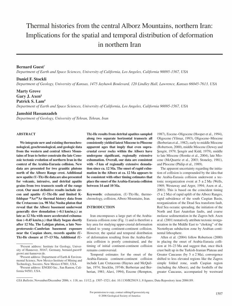
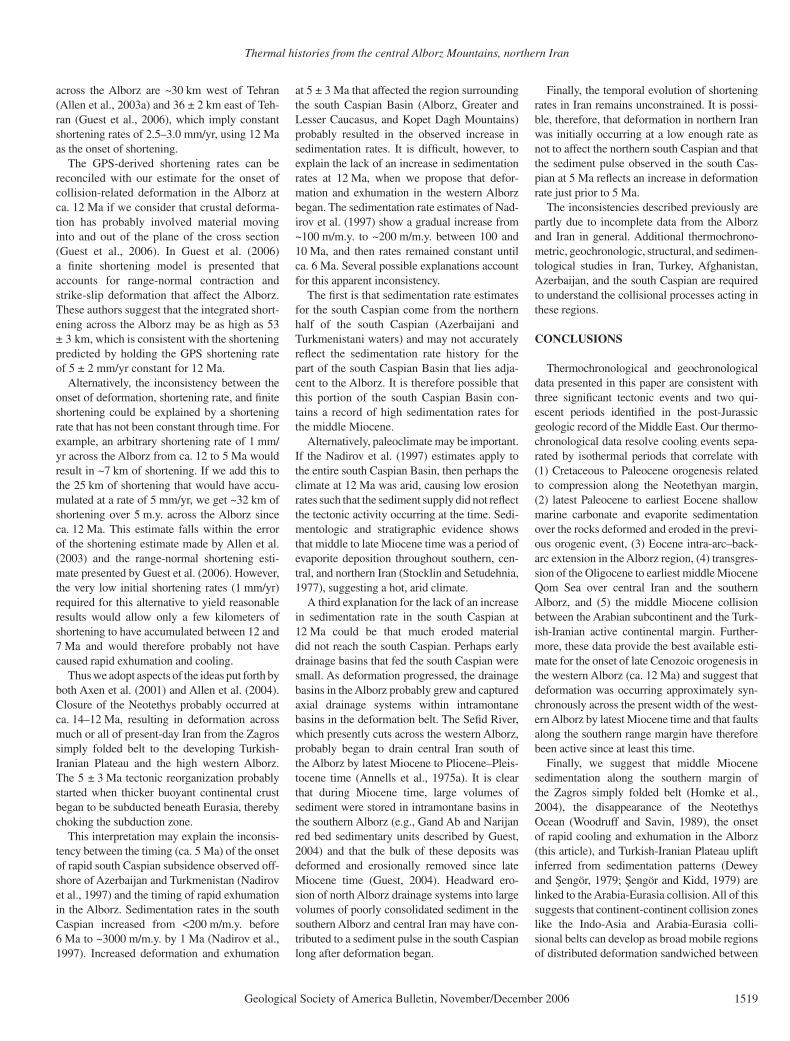
Iran encompasses a large part of the Arabia-Eurasia collision zone (Fig. 1) and is therefore a key area for studying upper-crustal deformation related to young continent-continent collision. However, the spatial and temporal distribution of deformation resulting from the Arabia-Eur-asia collision is poorly constrained, and the timing of initial continent-continent collision remains controversial.
Temporal estimates for the onset of the Arabia-Eurasia continent-continent collision include Late Cretaceous (Haynes and McQuil-lan, 1974; Stocklin, 1974b; Berberian and Ber-berian, 1981; Alavi, 1994), Eocene (Hempton,
1987), Eocene–Oligocene (Hooper et al., 1994), Oligocene (Yilmaz, 1993), Oligocene–Miocene (Berberian et al., 1982), early to middle Miocene (Robertson, 2000), middle Miocene (Dewey and Sengör, 1979; Sengör and Kidd, 1979), middle to late Miocene (Homke et al., 2004), late Mio-cene (McQuarrie et al., 2003; Stoneley, 1981), and Pliocene (Philip et al., 1989).
The apparent uncertainty regarding the initia-tion of collision is compounded by the idea that the Arabia-Eurasia collision underwent a tec-tonic reorganization event at 5 ± 2 Ma (Wells, 1969; Westaway and Arger, 1994; Axen et al., 2001). This is based on the coincident timing (5 ± 2 Ma) of rapid uplift of the Alborz Ranges, rapid subsidence of the south Caspian Basin, reorganization of the Dead Sea transform fault, Red Sea oceanic spreading, the initiation of the North and East Anatolian faults, and coarse molasse sedimentation in the Zagros belt. Axen at al. (2001) tentatively attribute tectonic reorga-nization in the Middle East to “choking” of the Neotethyan subduction zone by Arabian conti-nental lithosphere.
Allen et al. (2004) follow Robertson (2000) in placing the onset of Arabia-Eurasia colli-sion at 16–23 Ma and suggest that, once thick crust built up in the Turkish-Iranian Plateau and Greater Caucasus (by 5 ± 2 Ma), convergence shifted to less elevated regions like the Zagros simple folded zone, south Caspian region (including the Alborz), and the foothills of the greater Caucasus, accompanied by westward
Thermal histories from the central Alborz Mountains, northern Iran: Implications for the spatial and temporal distribution of deformation
in northern Iran
Bernard Guest†
Department of Earth and Space Sciences, University of California, Los Angeles, California 90095-1567, USA
Daniel F. StockliDepartment of Geology, University of Kansas, 1475 Jayhawk Boulevard, 120 Lindley Hall, Lawrence, Kansas 66045-7613, USA
Marty GroveGary J. Axen§
Patrick S. Lam#
Department of Earth and Space Sciences, University of California, Los Angeles, California 90095-1567, USA
Jamshid HassanzadehDepartment of Geology, University of Tehran, Tehran, Iran
GSA Bulletin; November/December 2006; v. 118; no. 11/12; p. 1507–1521; doi: 10.1130/B25819.1; 8 fi gures; Data Repository item 2006189.
†Present address: Institute for Geology, Univer-sity of Hannover, 30167, Germany, [email protected].
§Present address: Department of Earth & Environ-mental Science, New Mexico Institute of Mining and Technology, Socorro, New Mexico 87801, USA.
#Present address: ENGEO Inc., San Ramon, Cali-fornia 94583, USA.
Guest et al.
1508 Geological Society of America Bulletin, November/December 2006
extrusion of Turkey between the North and East Anatolian faults. This idea implies that defor-mation in collisional zones builds outward from discrete belts or plateau areas surrounding the suture and propagates into adjacent regions of low relief and crustal thickness. In this model, tectonic reorganization of the Middle East at 5 ± 2 Ma merely represents a shift in the locus of deformation outward over time. The idea that widespread tectonic reorganization is caused by choking of the subduction zone by the subduc-tion of thicker continental crust (e.g., Axen et al., 2001) implies that the deformation need not progress outward over time but begins rapidly throughout a broader region as lithospheric het-erogeneities respond to the collision.
We can begin to distinguish between these ideas by looking at the timing of deformation in the Alborz Mountains (Fig. 1), which lie 200 to 600 km northeast of the contact between Eurasia and Arabia. The goal is to determine if the pres-ent Alborz topography developed in response to the collision or developed earlier or later.
We present tectonic interpretations on the basis of thermochronological and geochrono-
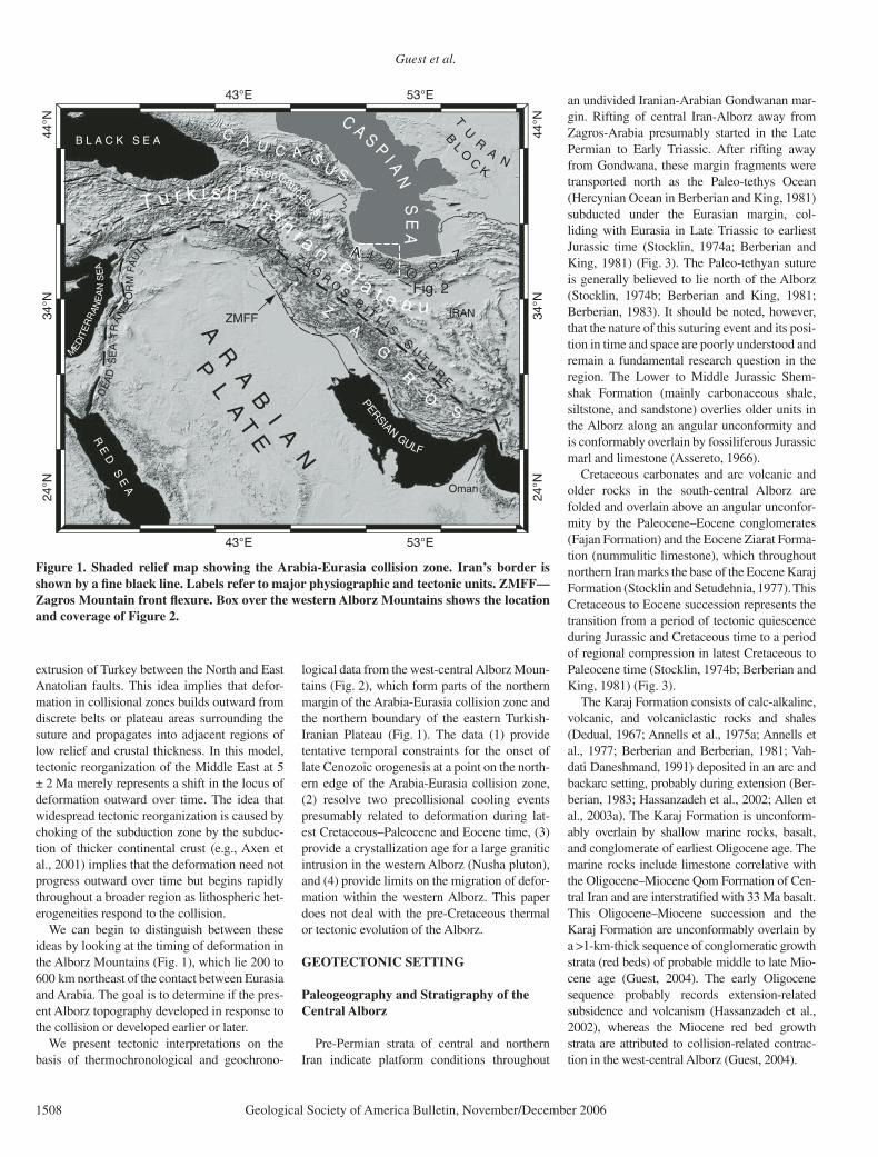
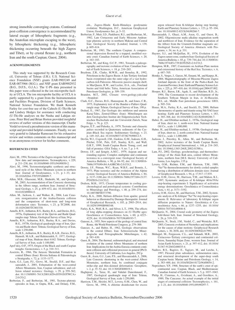
logical data from the west-central Alborz Moun-tains (Fig. 2), which form parts of the northern margin of the Arabia-Eurasia collision zone and the northern boundary of the eastern Turkish-Iranian Plateau (Fig. 1). The data (1) provide tentative temporal constraints for the onset of late Cenozoic orogenesis at a point on the north-ern edge of the Arabia-Eurasia collision zone, (2) resolve two precollisional cooling events presumably related to deformation during lat-est Cretaceous–Paleocene and Eocene time, (3) provide a crystallization age for a large granitic intrusion in the western Alborz (Nusha pluton), and (4) provide limits on the migration of defor-mation within the western Alborz. This paper does not deal with the pre-Cretaceous thermal or tectonic evolution of the Alborz.
GEOTECTONIC SETTING
Paleogeography and Stratigraphy of the Central Alborz
Pre-Permian strata of central and northern Iran indicate platform conditions throughout
an undivided Iranian-Arabian Gondwanan mar-gin. Rifting of central Iran-Alborz away from Zagros-Arabia presumably started in the Late Permian to Early Triassic. After rifting away from Gondwana, these margin fragments were transported north as the Paleo-tethys Ocean (Hercynian Ocean in Berberian and King, 1981) subducted under the Eurasian margin, col-liding with Eurasia in Late Triassic to earliest Jurassic time (Stocklin, 1974a; Berberian and King, 1981) (Fig. 3). The Paleo-tethyan suture is generally believed to lie north of the Alborz (Stocklin, 1974b; Berberian and King, 1981; Berberian, 1983). It should be noted, however, that the nature of this suturing event and its posi-tion in time and space are poorly understood and remain a fundamental research question in the region. The Lower to Middle Jurassic Shem-shak Formation (mainly carbonaceous shale, siltstone, and sandstone) overlies older units in the Alborz along an angular unconformity and is conformably overlain by fossiliferous Jurassic marl and limestone (Assereto, 1966).
Cretaceous carbonates and arc volcanic and older rocks in the south-central Alborz are folded and overlain above an angular unconfor-mity by the Paleocene–Eocene conglomerates (Fajan Formation) and the Eocene Ziarat Forma-tion (nummulitic limestone), which throughout northern Iran marks the base of the Eocene Karaj Formation (Stocklin and Setudehnia, 1977). This Cretaceous to Eocene succession represents the transition from a period of tectonic quiescence during Jurassic and Cretaceous time to a period of regional compression in latest Cretaceous to Paleocene time (Stocklin, 1974b; Berberian and King, 1981) (Fig. 3).
The Karaj Formation consists of calc-alkaline, volcanic, and volcaniclastic rocks and shales (Dedual, 1967; Annells et al., 1975a; Annells et al., 1977; Berberian and Berberian, 1981; Vah-dati Daneshmand, 1991) deposited in an arc and backarc setting, probably during extension (Ber-berian, 1983; Hassanzadeh et al., 2002; Allen et al., 2003a). The Karaj Formation is unconform-ably overlain by shallow marine rocks, basalt, and conglomerate of earliest Oligocene age. The marine rocks include limestone correlative with the Oligocene–Miocene Qom Formation of Cen-tral Iran and are interstratifi ed with 33 Ma basalt. This Oligocene–Miocene succession and the Karaj Formation are unconformably overlain by a >1-km-thick sequence of conglomeratic growth strata (red beds) of probable middle to late Mio-cene age (Guest, 2004). The early Oligocene sequence probably records extension-related subsidence and volcanism (Hassanzadeh et al., 2002), whereas the Miocene red bed growth strata are attributed to collision-related contrac-tion in the west-central Alborz (Guest, 2004).
43°E
43°E
53°E
53°E
24°N
24°N
34°N
34°N
44°N
44° N
ZMFF IRAN
Fig. 2
TU
RA
N
Oman
BL
OC
K
B L A C K S E A
MEDIT
ER
RAN
EA
NS
EA
AA L BO R
ZA L BO R
Z
ZA
G
R
OS
PERSIANGULF
A R A B I A N
PL A T E
C A U C A SU SLesser Caucasus
Z A GR
OS - B I T L I S
SU
TU
RE
C A S PI A
NS
EA
T u r k i s h I r an
i a nP l a t e a u
DE
AD
SE
AT
RA
NSF
OR
MFA
U
LT
R E D
S E A
Figure 1. Shaded relief map showing the Arabia-Eurasia collision zone. Iran’s border is shown by a fi ne black line. Labels refer to major physiographic and tectonic units. ZMFF—Zagros Mountain front fl exure. Box over the western Alborz Mountains shows the location and coverage of Figure 2.
Thermal histories from the central Alborz Mountains, northern Iran
Geological Society of America Bulletin, November/December 2006 1509
B F
ZB
F Z
KEY
36˚
Plio
cen
e an
d y
ou
ng
er s
edim
ent
Mio
cen
e (?
) red
bed
s (
= c
on
glo
mer
ate)
Olig
oce
ne
mar
ine
sed
imen
t
An
des
ite,
bas
alt,
trac
hyb
asal
t
Tuff,
turb
idit
e, li
mes
ton
e}Eo
cen
e K
araj
Fo
rmat
ion
Mes
ozo
ic ro
ck
Pale
ozo
ic ro
ck
Late
Pro
tero
zoic
rock
Intr
usi
on
s
Fau
lt
thru
st (t
eeth
on
H.W
.) s
trik
e-sl
ipFo
ld h
ing
e (a
nti
clin
e)
(s
yncl
ine)
KEY
51˚
50˚
37˚
U P
TU
PT
L P
TL
PT
U P
T
L P
T
N F
NF
N F
N T
TN
TT
M F
MF
MF
MF
N T
T
M F
MF
FKT
FKT
P TP T
F K
T
P T
Teh
ran
Kar
aj
Sou
thw
est
Cas
pia
n S
ea
Geo
logi
c M
ap o
f th
e W
este
rn a
nd C
entr
al
Alb
orz
Mou
ntai
ns, I
ran.
N
0
25
50
10
0
Kil
om
ete
rs
Ch
alu
s
Ras
ht
Qa
zvin
Lah
ijan
(U/P
b; A
r/A
r; (
U-T
h)/H
e)
Nus
ha (
U/P
b; A
r/A
r; (
U-T
h)/H
e)
Ala
m K
uh (
U/P
b; A
r/A
r; (
U-T
h)/H
e)
Ako
pol (
U/P
b; A
r/A
r; (
U-T
h)/H
e)
Diz
an (
(U-T
h)/H
e)
Cha
lus
Hig
hway
((U
-Th)
/He)
Loc
atio
n ke
y fo
r Alb
orz
sam
ple
tran
sect
s
Fig.
5a
Fig.
5a
Fig.
4aFi
g.4a
Fig.
6a
Fig.
6aFi
g. 8
aFi
g.8a
Fig.
5a
Fig.
4a
Fig.
6a
Fig.
7a
7a
Box
es s
how
map
bou
ndar
ies
and
num
ber
in u
pper
rig
ht c
orne
r re
fers
to th
e re
leve
nt f
igur
e nu
mbe
r.
2000
m
K T
KT
K T
KT
TGFZ
TGFZ
K T
K T
TGFZ
T F
TF
T F
Lahi
jan
plut
on
Nus
ha p
luto
nN
usha
plut
on
Ako
pol p
luto
nA
kopo
lplu
ton
Nus
ha p
luto
n
Ako
pol p
luto
n
x
x
x
x
x
x
x
x
xx
x
x
x
x
xx
x
Ala
m K
uh p
luto
n
Fig
ure
2. G
ener
aliz
ed g
eolo
gic
map
of
the
wes
t-ce
ntra
l Alb
orz
Mou
ntai
ns, c
ompi
led
from
our
fi el
d m
appi
ng a
nd t
he I
rani
an G
eolo
gica
l Sur
vey
(IG
S) 1
:250
,000
-sca
le s
heet
s (A
nnel
ls e
t al.,
197
5b; V
ahda
ti D
anes
hman
d, 1
991)
. Das
hed
boxe
s sh
ow lo
cati
ons
and
cove
rage
of fi
gur
es p
rese
nted
in th
is p
aper
, and
the
sym
bols
wit
hin
each
box
indi
cate
the
loca
tion
s of
ther
moc
hron
omet
ry s
ampl
e tr
anse
cts.
NF
—N
usha
faul
t; B
FZ
—B
arir
faul
t zon
e; K
T—
Kan
dava
n th
rust
; TG
FZ
—Ta
ng-e
-Gal
u fa
ult z
one;
UP
T—
uppe
r P
arac
han
thru
st;
LP
T—
low
er P
arac
han
thru
st; T
F—
Tale
ghan
fau
lt;
MF
—M
osha
fau
lt;
NT
T—
nort
h Te
hran
thr
ust;
FK
T—
Fah
rahz
ad-K
araj
thr
ust;
PT
—P
urka
n th
rust
.
Guest et al.
1510 Geological Society of America Bulletin, November/December 2006
Pliocene and younger gravels locally capped by Pliocene and Pleistocene andesite lava fl ows unconformably overlie folded and faulted Oli-gocene–Miocene rocks in and along the fl anks of the Alborz (Annells et al., 1975a). Outcrops of deformed Pliocene–Pleistocene conglomer-ate overlain in angular unconformity by gently tilted Quaternary gravels occur in the southern foothills of the range (Annells et al., 1975a; Alavi, 1996). The Quaternary gravels are locally folded and overturned where they are in thrust contact with Eocene or older bedrock along the
southern range fl ank. Pleistocene and younger rocks along the northern range margin are generally fl at lying and undeformed (Stocklin 1974a; Annells et al., 1977; Vahdati Danesh-mand, 1991).
Deformation
Faults in the Alborz vary in geometry and slip-sense and are typically discontinuous and anastomosing with no single structure domi-nating the range in terms of slip magnitude
(Fig. 2). Faults and folds are oriented subparal-lel to the range boundaries, and faults generally dip toward the core of the range (Annells et al., 1975a; Annells et al., 1977; Haghipour et al., 1987; Shahrabi, 1991; Vahdati Daneshmand, 1991; Allen et al., 2003b). Earthquake focal mechanisms show that active deformation is partitioned into sinistral strike-slip and reverse-thrust faulting (Priestley et al., 1990; Jackson et al., 2002). It is clear, however, that earlier Ceno-zoic deformation also was accommodated by dextral strike-slip and normal faulting (Axen et al., 2001; Guest et al., 2006).
THERMOCHRONOLOGY AND GEOCHRONOLOGY
Sampling Strategy
Most of our analytical efforts centered around the use of apatite and zircon (U-Th)-He meth-ods to constrain the denudation history of the upper crust within the Alborz. Two sampling strategies were employed, depending upon our objectives. In selected instances we collected samples along transects in steep areas that afforded suffi cient topographic relief between samples (~100 m) to permit us to apply the apa-tite and zircon (U-Th)-He systems to constrain denudation histories (e.g., Axen et al., 2001; Stockli et al., 2000). (U-Th)-He ages for apatite and zircon in a vertical profi le through the upper crust are expected to decrease as a function of depth within the zone of partial He retention. The nature of the profi les depends upon topog-raphy and exhumation rates. When topographic controls are well understood, apatite and zircon (U-Th)-He age results from elevation profi les can be analyzed together with estimates of geo-thermal gradient to estimate denudation history (Reiners et al., 2002; Stockli et al., 2000; Wolf et al., 1998; Wolf et al., 1996). K-feldspar was collected for complementary thermal history modeling on the basis of 40Ar/39Ar multidif-fusion domain approach (e.g., Lovera et al., 1989, 1997, 2002). We also carried out recon-naissance-style horizontal transects along river valleys or along ridgelines in an attempt to use the apatite (U-Th)-He system to identify and quantify thermal history discontinuities across geological structures. Samples in horizontal transects were collected at ~1 km intervals.
Analytical Methods
The (U-Th)-He procedures employed to determine cooling ages for apatite and zircon follow the methods described by House et al. (2000) and Takahiro et al. (2003) for apatite and zircon, respectively. All analyses were carried
v v v
v v vv v v
v v v
v v v
v v v
v v v
Unexposed metamorphic basementLate Proterozoic
Cambrian
Ordovician - Silurian
Middle Triassic
Early Jurassic
Eocene
Paleocene
Pliocene
Oligocene
Miocene
Possible evaporites within the Kahar Fm.
Cambrian - M. Triassic mixed Cambrian - M. Triassic mixedclastic-carbonate platform strataclastic-carbonate platform strataCambrian - M. Triassic mixed clastic-carbonate platform strata
Possible early Paleozoic rifting
Palaeo-Tethyan Palaeo-TethyanmetamorphicsmetamorphicsPaleo-Tethyan metamorphics (??)
Rhaetic-LiassicRhaetic-LiassicShemshak Fm.Shemshak Fm.Rhaetic-LiassicShemshak Fm.
Pliocene-Quaternary sinistral transpression NS
Late Cretaceous-Late Cretaceous-Paleocene Paleocenecompressioncompression
Late Cretaceous-Paleocene compression
Cretaceous
Miocene compression Miocene compression(dextral transpression ?)(dextral transpression ?)
EoceneEoceneextension ?extension ?
Miocene compression (dextral transpression ?)
Eoceneextension ?
Alborz collide with Alborz collide withEurasiaEurasiaAlborz collide with Eurasia
Kahar Fm.
Kahar Fm.
Kahar Fm.
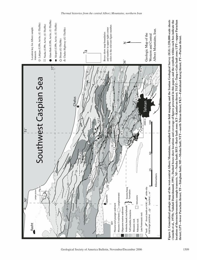
Figure 3. Simplifi ed tectonostratigraphy of the Alborz Mountains, modifi ed from Allen et al. (2003).
Thermal histories from the central Alborz Mountains, northern Iran
Geological Society of America Bulletin, November/December 2006 1511
out on single grains. Data tables are presented in the GSA Data Repository (DR1.3).1 Experi-mentally derived diffusion parameters suggest that He is not retained in apatite crystals above ~80 °C, is partially retained between ~80 °C and ~40 °C, and entirely retained below ~40 °C (Farley, 2000; Stockli et al., 2000; Wolf et al., 1998; Wolf et al., 1996). Diffusion experiments by Farley (2000) suggest a bulk closure temper-ature (T
c) for He in apatite of ~65 °C to ~75 °C,
assuming monotonic cooling at 10 °C/m.y. The zircon (U-Th)-He system diffusion experi-ments suggest a minimum T
c for He in zircon
of 190 °C (for monotonic cooling at 10 °C/m.y.; Reiners et al., 2002). The CLOSURE program by Brandon (2002), available at www. geology.yale.edu/~brandon/, provides a T
c range of
~150 °C to 201 °C for cooling rates ranging from 0.1 °C/m.y. to 40 °C/m.y., respectively. This program uses Dodson’s (1973) approach to calculate values of T
c as a function of cool-
ing rate from effective diffusion radius (r), and Arrhenius parameters determined by Reiners et al. (2002).
Limited U-Pb analysis of zircon was car-ried out using the UCLA Cameca ims-1270 ion-microprobe to determine the crystallization ages of two plutonic bodies within the Alborz Ranges. The analytical procedures employed are described in Lam (2002) and Schmitt et al. (2003). All ages are reported with 2σ standard errors. Additional details and U-Pb data tables and plots are presented in the Data Repository (DR1.1; see footnote 1). K-feldspar 40Ar/39Ar thermal history modeling was carried out at UCLA using procedures described by Quidel-leur et al. (1997), Harrison et al. (1994), and Lovera et al. (1989, 1997). Additional details, data tables, and relevant graphs are presented in the Data Repository (DR1.2; see footnote 1).
TRANSECT DESCRIPTIONS AND RESULTS
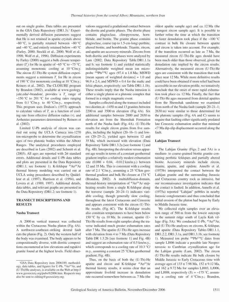
Nusha Transect
A 2000 m vertical transect was collected within the Cretaceous Nusha pluton (Fig. 4A). A northwest-southeast–striking dextral fault cuts the pluton (Fig. 2). Only the western half of the body was examined. The body appears to be compositionally diverse, with dioritic composi-tions encountered at low elevations and rapakivi granite found at the highest levels. Field obser-
vations suggested a gradational contact between the diorite and granite phases. The diorite phase contains plagioclase, clinopyroxene, horn-blende, and biotite. The granite phase contains plagioclase, coarse (up to 1.5-cm-long) perthite, altered biotite, and hornblende. Titanite, zircon, and apatite are accessory minerals. Zircons from both dioritic and felsic phases were analyzed by Lam (2002; Data Repository Table DR1.1.1a and b; see footnote 1) and yielded statistically indistinguishable weighted mean ion micro-probe 206Pb/238U ages (97.4 ± 1.8 Ma; MSWD [mean square of weighted deviates] = 1.0 and 96.9 ± 2.4, and MSWD = 0.4 for the mafi c and felsic phases, respectively; see Table DR1.1.1b). These results imply that the Nusha intrusion is either a single pluton or a plutonic complex that formed in a single magmatic event.
Samples collected along the transect included two diorites at ~1450 m and 13 granites between 2200 m and 3500 m elevation (Fig. 4A). Six additional samples between 2000 and 2650 m elevation are from the Shemshak Formation north of the Nusha fault (Fig. 4A). (U-Th)-He results for single zircon grains from fi ve sam-ples, including the highest (20–16–1) and low-est (20–25–2), yielded ages between 12 and 35 Ma, which increased with elevation (Data Repository Table DR1.3.2a [see footnote 1] and Fig. 4B). Interpreting the elevation versus appar-ent age results in terms of a constant geothermal gradient implies a relatively modest exhumation rate (0.086 + 0.04, –0.012 km/m.y.) between 12 and 35 Ma. This is consistent with a cooling rate of 2.1 °C/m.y., assuming a 25 °C/km geo-thermal gradient and bulk He closure at 174 °C (Brandon, 2002). A multidiffusion-domain, thermal-history interpretation of 40Ar/39Ar step-heating results from a single K-feldspar along the traverse (sample 20–24–1) indicates vari-able cooling, though generally slow cooling, throughout the latest Cretaceous and Cenozoic and appears consistent with the zircon (U-Th)-He results (Fig. 4C). The K-feldspar results also constrain temperatures to have been below 150 °C by ca. 10 Ma. In contrast, apatite (U-Th)-He results from eight samples along the tra-verse indicated much greater exhumation rates after 7 Ma. The apatite (U-Th)-He ages increase with elevation from 4 to 7 Ma (Data Repository Table DR 1.3.2b [see footnote 1] and Fig. 4B) and suggest an exhumation rate of 0.5 km/m.y., which corresponds to a cooling rate of 10.3 °C/m.y., assuming a constant 25 °C/km geothermal gradient; Fig. 4B).
Thus, on the basis of both the (U-Th)-He apatite and zircon and K-feldspar 40Ar/39Ar thermal history results, it seems clear that an approximate fi vefold increase in denudation rate occurred somewhere between ca. 7 Ma (the
oldest apatite sample age) and ca. 12 Ma (the youngest zircon sample age). It is possible to further refi ne the time at which the transition to faster denudation took place if the ~100 °C contrast in bulk He closure between apatite and zircon is taken into account. For example, if the transition occurred as late as 7 Ma, the measured zircon (U-Th)-He ages should have been much older than those observed, given the denudation rate implied by the zircon results. Alternatively, the measured zircon (U-Th)-He ages are consistent with the transition that took place near 12 Ma. While more defi nitive results could have been obtained if more relief had been accessible in our elevation profi le, we tentatively conclude that the onset of more rapid exhuma-tion took place ca. 12 Ma. Finally, the fact that (U-Th)-He ages measured from detrital apatites from the Shemshak sandstone we examined from north of the Nusha fault (sample 20–21–1; 2630 m) were similar to those determined for the plutonic samples (Fig. 4A and C) seems to require that faulting either signifi cantly predated late Cenozoic exhumation and/or that minimal <7 Ma dip-slip displacement occurred along the fault.
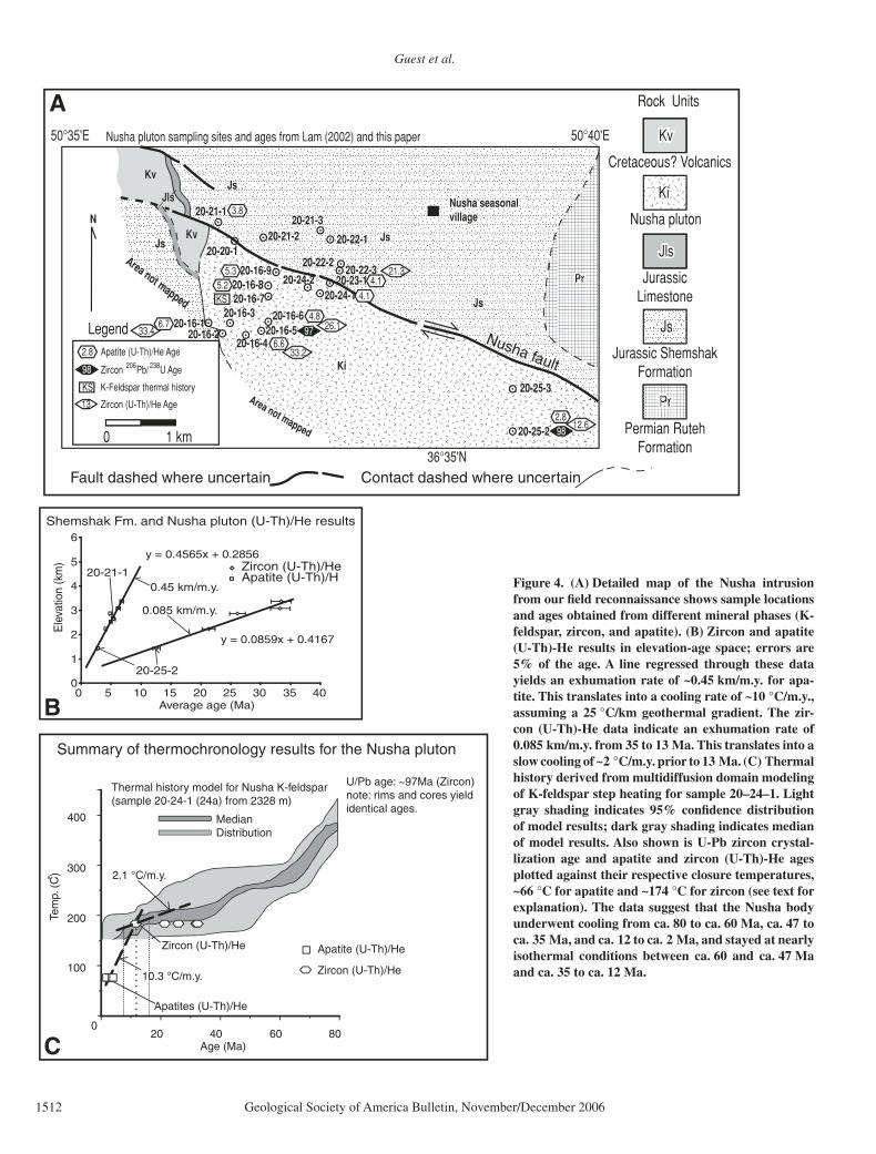
Lahijan Transect
The Lahijan Granite (Figs. 2 and 5A) is a medium- to coarse-grained biotite granite con-taining perthitic feldspars and partially altered biotite. Accessory minerals include zircon, titanite, apatite, and epidote. Annells et al. (1975b) interpreted the contact between the Lahijan granite and the surrounding Jurassic and Cretaceous country rock as intrusive, but our reconnaissance investigation indicates that the contact is faulted. In addition, Annells et al. (1975a) reported “Lahijan” pebbles in nearby Jurassic conglomerates and thus concluded that initial erosion of the pluton had begun by Early to Middle Jurassic time.
We collected eight samples over an eleva-tion range of 500 m from the lowest outcrops to the summit ridge south of Layla Kuh vil-lage (Fig. 5A). We conducted U-Pb, 40Ar/39Ar, and (U-Th)-He analyses on zircons, K-feldspar, and apatite (Data Repository Tables DR1.1.1, DR1.2.2, DR1.3.1a, and DR1.3.1b; see footnote 1). Measured ion probe 206Pb/238U dates from sample LJ006 indicate a possible late Neopro-terozoic to Cambrian crystallization age for the Lahijan granite (Lam, 2002). The zircon (U-Th)-He results indicate He bulk closure by Middle Jurassic to Early Cretaceous time with average ages of 133 ± 7.98 Ma, 152 ± 9.12 Ma, and 162 ± 9.72 Ma for samples LJ003, LJ006, and LJ008, respectively (Tc = ~175 °C, assum-ing a cooling rate of 4 °C/m.y.; Brandon,
1GSA Data Repository item 2006189, methodol-ogy, data tables, and fi gures for U-Pb, 40Ar/39Ar, and (U-Th)/He analyses, is available on the Web at http://www.geosociety.org/pubs/ft2006.htm. Requests may also be sent to [email protected].
Guest et al.
1512 Geological Society of America Bulletin, November/December 2006
20 40 60 80
U/Pb age: ~97Ma (Zircon)note: rims and cores yield identical ages.
2.1 °C/m.y.
10.3 °C/m.y.100
300
400
200
MedianDistribution
Apatites (U-Th)/He
Zircon (U-Th)/He
C
Apatite (U-Th)/He
Zircon (U-Th)/He
Age (Ma)
Tem
p. (
C)
0
Rock Units
KvKvKv
PrPr
JsJs
KiKi
JlsJlsJls
Cretaceous? Volcanics
Nusha pluton
JurassicLimestone
Jurassic ShemshakFormation
Permian RutehFormation
0 1 km
20-16-120-16-3
20-16-220-16-4
20-16-520-16-6
20-21-1
20-20-120-21-2
20-24-220-24-1
20-23-120-22-3
20-22-2
20-21-3
20-22-1
Nusha seasonal Nusha seasonalvillagevillageNusha seasonal village
20-25-3
20-25-2
36°35'N
50°35'E 50°40'E
Area not mapped
Ki
Area not mapped
JsJs
PrPr
JsKv
Kv
JlsJs
Js
Ki
Js
Pr
JsKv
Kv
JlsJs
Js20-16-720-16-8
20-16-9
Legend
13
33.4
33.2
12.6
26.1
21.3
98
98
976.7
6.6
4.8
5.25.3
KS
3.8
4.14.1
2.8
K-Feldspar thermal historyKS
Apatite (U-Th)/He Age
Zircon (U-Th)/He Age
2.8
Zircon Pb/ U Age206 238
Nusha pluton sampling sites and ages from Lam (2002) and this paper
A
Nusha fault
Fault dashed where uncertain Contact dashed where uncertain
N
Thermal history model for Nusha K-feldspar(sample 20-24-1 (24a) from 2328 m)
Summary of thermochronology results for the Nusha pluton
B
20-25-2
20-21-1
Shemshak Fm. and Nusha pluton (U-Th)/He results
0.45 km/m.y.
0.085 km/m.y.
y = 0.0859x + 0.4167
y = 0.4565x + 0.2856
0
1
2
3
4
5
6
0 5 10 15 20 25 30 35 40Average age (Ma)
Ele
vatio
n (k
m) Zircon (U-Th)/He
Apatite (U-Th)/H Figure 4. (A) Detailed map of the Nusha intrusion from our fi eld reconnaissance shows sample locations and ages obtained from different mineral phases (K-feldspar, zircon, and apatite). (B) Zircon and apatite (U-Th)-He results in elevation-age space; errors are 5% of the age. A line regressed through these data yields an exhumation rate of ~0.45 km/m.y. for apa-tite. This translates into a cooling rate of ~10 °C/m.y., assuming a 25 °C/km geothermal gradient. The zir-con (U-Th)-He data indicate an exhumation rate of 0.085 km/m.y. from 35 to 13 Ma. This translates into a slow cooling of ~2 °C/m.y. prior to 13 Ma. (C) Thermal history derived from multidiffusion domain modeling of K-feldspar step heating for sample 20–24–1. Light gray shading indicates 95% confi dence distribution of model results; dark gray shading indicates median of model results. Also shown is U-Pb zircon crystal-lization age and apatite and zircon (U-Th)-He ages plotted against their respective closure temperatures, ~66 °C for apatite and ~174 °C for zircon (see text for explanation). The data suggest that the Nusha body underwent cooling from ca. 80 to ca. 60 Ma, ca. 47 to ca. 35 Ma, and ca. 12 to ca. 2 Ma, and stayed at nearly isothermal conditions between ca. 60 and ca. 47 Ma and ca. 35 to ca. 12 Ma.
Thermal histories from the central Alborz Mountains, northern Iran
Geological Society of America Bulletin, November/December 2006 1513
Apatite average(U-Th)/He ages
0
50
100
150
200
250
0 5 10 15 20 25Age (Ma)
Ele
vatio
n (m
) Lahijan apatiteaverage ages
U/Pb age: 551 ± 9 Ma (Zircon)from Lam (2002). Note: Scatter in the U/Pb dataallows that the crystallization agemay be as young as 527 Ma or asold as 578 Ma.
B
LJ008 age
Zircon (U-Th)/He ages
LJ006 average age
LJ003 average age
LJ006 ages
LJ006 ages
LJ007 ages
LJ008 ages
LJ003 ages
Lahijan apatite age vs. elevation
Lahijan apatite age vs. temperature
.
0 m
Langerud
Layla Kuh
Lahijan
100?m?contour?interval
100
200
300
37°10'N
37°05'N
50°05'E50°00'E 50°10'E
LJ008
LJ007LJ006LJ005LJ004
LJ003LJ002
LJ001552552
KS
17.2
16.1
13.3
20-32-1
133
133
152
162
Legend
Zircon??????U/????Pb?Age
K-Feldspar?thermal?historyKS
Apatite?(U-Th)/He?Age
Zircon?(U-Th)/He?Age238????????206551551
17.2
0????????1????????2?km? ? ?
Strike?and?Dip?of?beddin
Contact,?dashed?where?approximately?located
Fault
Sample?site
45-85
20-45
20-45
20-45
20-45
Rock??Units
JKlsJKls
JKlsJKls
CmCm
CmCmCmCm
JKss/shJKss/sh
JKss/shJKss/shJKss/shJKss/sh
JKss/shJKss/sh
JKss/shJKss/sh
JKss/shJKss/sh
JKvJKv
JKvJKv
JKvJKv
CmCm
Cambrian?Lahijan?Granite
JKv
Jurassic-Cretaceous?volcanic?rocks
JKss/shJKss/shJKss/sh
Jurassic-Cretaceous?sandstone?and?shale
JKlsJKls
Jurassic-Cretaceouslimestone
Precambrian?Metamorphics
PCm
PCmPCm
PCmPCm
JKls
JKls
Cm
CmCm
JKss/sh
JKss/shJKss/sh
JKss/sh
JKss/sh
JKss/sh
JKv
JKv
JKv
PCm
PCm
Quaternary?Cover
Q
Q
Q
Q Q
A
Figure 5. (A) Generalized geologic map of the Lahijan intrusion and surrounding geology, based on our reconnaissance and the Geologi-cal Survey of Iran’s Qazvin Rasht sheet (1:250,000 scale; Annells et al., 1975b). The map shows sample locations and ages obtained from different mineral phases (zircon and apatite). (B) Upper plot shows apatite (U-Th)-He results plotted in elevation-age space. Lower plot shows apatite and zircon (U-Th)-He results plotted in temperature-time space, assuming 75 °C and 180 °C closure temperature for apatite and zircon, respectively. These data, though somewhat scattered, suggest slow cooling for the Lahijan pluton since Middle Jurassic time.
Guest et al.
1514 Geological Society of America Bulletin, November/December 2006
2002). While these are not in agreement with monotonic thermal histories calculated from the K-feldspar 40Ar/39Ar data, the latter are not robust inasmuch as the measured age spectra are poorly fi t by the multidiffusion-domain results (Data Repository Fig. DR1.2.1; see footnote 1). The K-feldspar systematics could be explained by transient heating during latest Cretaceous or early Tertiary time, consistent with the presence of Late Cretaceous (Lam, 2002; this paper) and Paleocene plutons (Axen et al. 2001) elsewhere in the range. However, the lack of detailed geo-chronology, mapping, and structural data from the Lahijan area makes model calculations that assume reheating impractical, as it would be impossible at this stage to determine the extent of, and mechanism for, reheating.
Two apatite grains were dated from each of three samples, producing apatite (U-Th)-He average ages that cluster in the middle Miocene (Data Repository Table DR1.3.2b, see footnote 1; Fig. 5B). These ages indicate that the Lahijan granite cooled through the ~75 °C isotherm dur-ing early to middle Miocene time (Fig. 5B). It is unclear what causes the scatter in these data, but it may be explained by slight variations in diffusive properties, long residence times in the apatite partial retention zone, and inaccuracies in grain-size measurements. Slight variations in diffusive properties from grain to grain or inaccuracies in corrections for recoil-induced He loss can lead to large differences in the total amount of He retained after 10 m.y. (Farley et al., 1996).
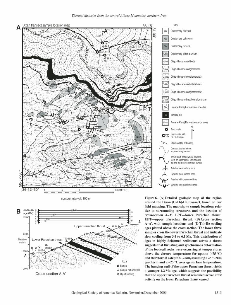
Dizan Transect
This traverse (Fig. 6A) rises 780 m over a horizontal distance of ~3 km and transects the Parachan thrust system (Data Repository Table DR1.3.3; see footnote 1). The topographi-cally lowest samples we collected were Oligo-cene–Miocene clastic sedimentary rocks within the footwall of the Parachan thrust system. Two samples of detrital apatite (20-35-1 and 20-36-1) yielded U-Th-He ages of 3.4 ± 0.1 Ma and 4.7 ± 0.3 Ma, respectively (Fig. 6A). Above the lower Parachan thrust (i.e., within the middle plate), a sample of trachyandesite from the Karaj Formation yielded an apatite U-Th-He age of 6.1 ± 0.3 Ma (sample 20–36–3; Fig. 6A). Structurally and topographically higher within the upper plate (i.e., above the upper Parachan thrust) we sampled the Karaj Formation and obtained a (U-Th)-He age from detrital apatite of 4.2 ± 0.2 Ma (Fig. 6A).
The interpretation of these data is strongly limited by the small number of analyzed sam-ples, the fact that the samples are detrital, and an incomplete knowledge of the paleotopogra-
phy and stratigraphic thicknesses in this region. Nevertheless, the overall similarity in apatite U-Th-He age, coupled with the fact that all mea-sured ages are signifi cantly younger than their sedimentary or volcanic protoliths, strongly implies a shared history during which all of the supracrustal rocks have been exhumed from >3 km depth during late Miocene–Pliocene time. Moreover, the absence of signifi cant age discontinuities across faults of the Parachan thrust system implies that rocks of appreciably different structural levels have not been juxta-posed since the late Miocene–Pliocene.
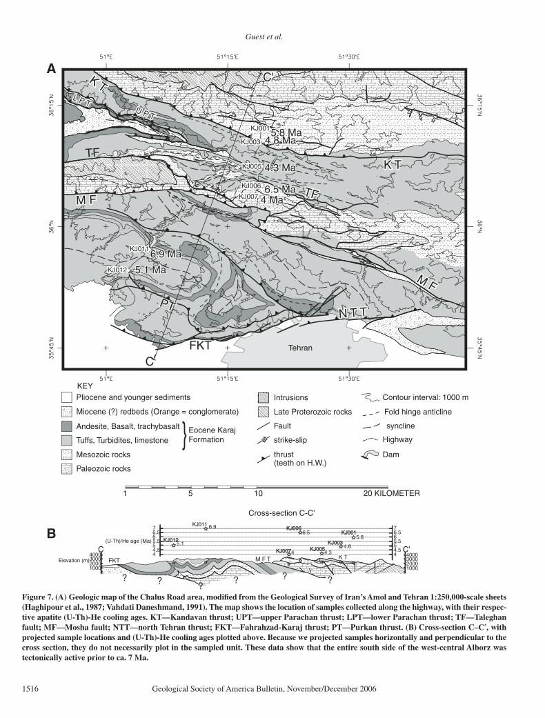
Chalus Road Transect
Samples on this transect were collected along the Karaj-Chalus Highway, which crosses the Alborz northwest of Tehran (Data Repository Table DR1.3.4, see footnote 1; Fig. 7A). This ~65 km transect starts ~10 km north of Karaj at ~1800 m, crosses the ~4000 m range crest, and continues northeast another ~10 km to a point at 2300 m elevation (Fig. 7A). Samples were col-lected mainly from volcaniclastic and siliciclastic units of Tertiary, Mesozoic, and Paleozoic age; one sample (KJ012) is from a Tertiary diorite.
Apatite was analyzed by the (U-Th)-He method from seven samples along this transect. The ages shown in Figure 7 represent the aver-age age obtained from two multigrain analyses obtained for each sample (except for sample KJ003 from which we report only one of the ages obtained) (Data Repository Table DR1.3.4, see footnote 1; Fig. 7B). Whereas the interpre-tation of these results is limited by the level of knowledge of the geology along the transect, the consistency of the apatite (U-Th)-He ages makes this a moot point (Fig. 7A and B). The fact that all of the Karaj Highway samples record cooling between 7 and 4 Ma (0.2–0.4 Ma uncertainty) suggests that the entire south side of the Alborz Range was undergoing signifi cant (<2–3 km) denudation by latest Miocene time.
DISCUSSION
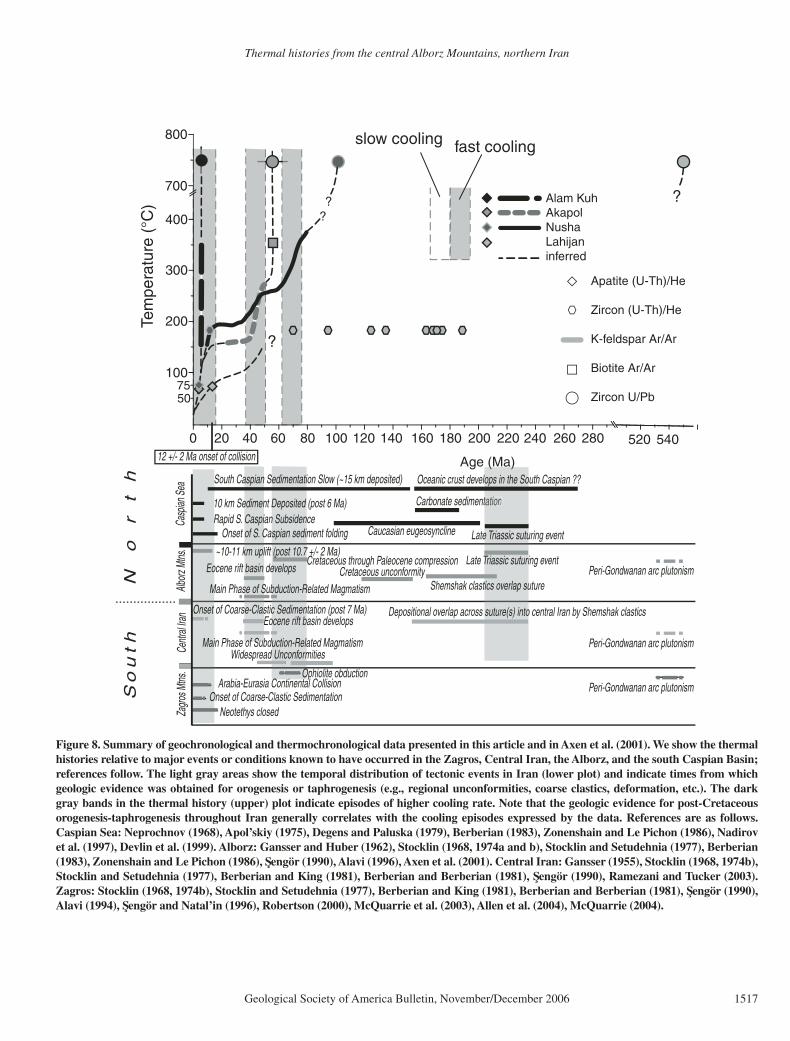
Both new and previously obtained apatite and zircon (U-Th)-He and K-feldspar 40Ar/39Ar ther-mal-history data reveal that both basement and supracrustal rocks underlying the Alborz Range of northern Iran have undergone a relatively coherent late Miocene–Pliocene exhumation history related to the continuing Arabia-Eurasia collision in this region. In the following sections we compile our data with previous results from the Akapol and Alam Kuh plutons (Fig. 2) pre-sented by Axen et al. (2001) to refi ne previously advanced models for the geologic development of the Alborz region (Fig. 8).
Intrusive Events
There are no known exposures of crystalline basement rocks in the Alborz. Consequently, the new geochronological results from the Lahijan and Nusha plutons have important implications for our understanding of the tectono-plutonic development of northern Iran. The U-Pb ion probe data for the Lahijan pluton suggest intru-sion within the late Neoproterozoic to Cambrian time interval (Lam, 2002).
Intrusive and volcanic rocks of comparable age in central Iran have been attributed to the Peri-Gondwanan (or Proto-Tethyan) orogenic episode (Ramezani and Tucker, 2003). The pres-ence of Peri-Gondwanan intrusions to the south (central Iran) and to the north (Lahijan) of the Alborz Ranges confi rms the notion that all litho-sphere south of the Caspian was once part of the undivided Gondwana margin (Stocklin, 1974b; Berberian and Berberian, 1981; Ramezani and Tucker, 2003). Thus, the suture between Turan and northern Iran might lie to the north of the Lahijan pluton.
The 97 ± 2 Ma age of the Nusha pluton indi-cates intrusion during an Aptian to Maastrichtian (121–65 Ma) period of magmatism and carbon-ate deposition in the western Alborz and Talesh Mountains (Annells et al., 1975a; Clark et al., 1975). If this Alborz-Talesh Cretaceous mag-matism was caused by Neotethyan subduction along the present Zagros-Bitlis suture (Berbe-rian and Berberian, 1981; Berberian and King, 1981), then the present width of the Cretaceous arc is ~380 km, measured from arc-related Cre-taceous igneous rocks just north of the suture to outcrops in the Alborz and Talesh. This implies either that Cretaceous arc volcanism was spread over an anomalously wide area in Iran, as sug-gested for Eocene arc volcanism (Berberian and Berberian, 1981), or that this volcanism was concentrated along an initially narrower volca-nic arc that was later rifted apart, thereby dis-tributing the arc rocks over a wider region (e.g., Hassanzadeh et al., 2002). The latter idea is consistent with evidence for Eocene extensional subsidence present in the southwestern Alborz, and Eocene backarc or intra-arc rift volcanism in central Iran (Hassanzadeh et al., 2002; Guest, 2004; this study).
Pre-Neogene Tectonism
There is geological evidence for orogenic and taphrogenic events that predate the Arabia-Eur-asia collision in Iran (Berberian and King, 1981; Berberian, 1983; Sengör, 1990; Sengör and Natal’in, 1996) (Fig. 3). Our thermal history results appear to correlate with the important post-Jurassic tectonically active and quiescent
Thermal histories from the central Alborz Mountains, northern Iran
Geological Society of America Bulletin, November/December 2006 1515
T
T
A'
A
36-15'
36-12'-30"
51-00'
50-5
7'-3
0"
3000 m
2500 m
TsTs
EkvEkv
EkvEkv
EkvEkv
EkssEkss
QoalQoal QoalQoal
QteQte
QteQte
Qc
QcQcQcQc
QcQc
QoalQoal
QoalQoal
QoalQoal
QteQte
QteQte
QteQteQteQte
QteQte
QoalQoal QteQte
TsTs
TsTs
O-MrO-Mr
O-MrsO-Mrs
O-MrO-Mr
O-MbcO-Mbc
O-MrO-Mr
O-MbcO-Mbc
O-MrO-Mr
O-MrO-Mr
O-MrO-MrO-Mrc3O-Mrc3
O-Mrc3O-Mrc3
O-Mrc2O-Mrc2
QteQte
QteQte
QteQte
Qc
QalQal
QteQte
QteQteQte
QalQal
O-MgcO-Mgc
O-MgcO-Mgc
O-MgcO-Mgc
O-MgcO-Mgc
QcQc
O-MrO-Mr
O-MrO-Mr
7-35-17-35-1EkssEkss
EkvEkv
EkvEkvEkv
Ekv
Ekv
Ekss
Qoal Qoal
Qte
Qoal
Qoal
Qoal
Qte
Qte
QteQte
Qoal Qte
Ts
O-Mr
O-Mrs
O-Mr
O-Mbc
O-Mr
O-Mbc
O-Mr
O-Mr
O-MrO-Mrc3
O-Mrc3
O-Mrc2
Qal
Qte
QteQte
Qal
O-Mgc
O-Mgc
O-Mgc
O-Mgc
Qc
O-Mr
O-Mr
Ekv
Ekv
10101111
7777
7676
4545
4040
2222
2222
8080
2323
8585
7
5656
2626
51516868
4545
5555
2424
3030
8181
37373333
2828
2828
2828
5050
5454
6868
5555
6060
7474
4040
6767 8585 4040
3232
20-35-220-35-2
6-151-16-151-1
20-34-120-34-1
20-36B-120-36B-1
20-35-120-35-120-36-120-36-1
20-36-220-36-2 20-37-120-37-1
20-36-420-36-4
20-36-320-36-3
20-41-220-41-2
20-39-220-39-2
20-41-120-41-1
20-39-320-39-3
N
1 KILOMETER1 .5 0
contour interval: 100 m
Dizan transect sample location map
3.4
4.7
4.2
6.1
QalQal Quaternary alluvium
QoalQoalQoal Quaternary older alluvium
QcQc Quaternary colluvium
QteQte Quaternary terrace
O-MrO-MrO-Mr Oligo-Miocene red beds
O-MrsO-MrsO-Mrs Oligo-Miocene red silts/shales
O-MgcO-MgcO-Mgc Oligo-Miocene conglomerate
O-Mrc3O-Mrc3O-Mrc3 Oligo-Miocene conglomerate3
O-Mrc2O-Mrc2O-Mrc2 Oligo-Miocene conglomerate2
O-MbcO-MbcO-Mbc Oligo-Miocene basal conglomerate
EkvEkvEkv Eocene Karaj Formation andesites
EkssEkssEkss Eocene Karaj Formation sandstones
TsTs Tertiary sill
KEY
Strike and Dip of bedding
Contact, dashed where approximately located
Anticline axial surface trace
Anticline with overturned limb
Syncline axial surface trace
Syncline with overturned limb
4.2
Sample site
Sample site with (U-Th)/He age
U P TU P TU P T
L P TL P TL P T
A
20-35-120-35-120-36-120-36-1
20-36-320-36-3
20-39-320-39-333.544.555.56
33.544.555.56
3.4
6.0
4.24.7
(U-Th)/Heage (Ma)
3000
3500
2500
2000
Elevation (meters)
?
?
?
??
??
A'
A
Upper Parachan thrust
Lower Parachan thrust
KEYSample
Sample not analyzed
Dip of beddingCross-section A-A’
B
Thrust fault, dotted where covered, teeth on upper plate. Bar indicates dip and dip direction of fault surface
Figure 6. (A) Detailed geologic map of the region around the Dizan (U-Th)-He transect, based on our fi eld mapping. The map shows sample locations rela-tive to surrounding structures and the location of cross-section A–A′. LPT—lower Parachan thrust; UPT—upper Parachan thrust. (B) Cross section A–A′, with sample locations and (U-Th)-He cooling ages plotted above the cross section. The lower three samples cross the lower Parachan thrust and indicate slow cooling from 3.4 to 6.1 Ma. This distribution of ages in highly deformed sediments across a thrust suggests that thrusting and synchronous deformation of the footwall rocks were occurring at temperatures above the closure temperature for apatite (~75 °C) and therefore at a depth >~2 km, assuming a 25 °C/km geotherm and a ~25 °C average surface temperature. The hanging wall of the upper Parachan thrust yields a younger 4.2 Ma age, which suggests the possibility that the upper Parachan thrust remained active after activity on the lower Parachan thrust ceased.
Guest et al.
1516 Geological Society of America Bulletin, November/December 2006
?
Tehran
KEYPliocene and younger sediments
Miocene (?) redbeds (Orange = conglomerate)
Andesite, Basalt, trachybasalt
Tuffs, Turbidites, limestone }Eocene Karaj Formation
Mesozoic rocks
Paleozoic rocks
Late Proterozoic rocks
Intrusions
Fault syncline
thrust (teeth on H.W.)
strike-slip Highway
Dam
Contour interval: 1000 m
KJ012
KJ011
KJ007
KJ006
KJ005
KJ003
KJ001
KJ012
KJ011
KJ007
KJ006
KJ005
KJ003
KJ001
5.1 Ma5.1 Ma
6.9 Ma6.9 Ma
6.5 Ma6.5 Ma
4.3 Ma4.3 Ma
4.8 Ma4.8 Ma
4 Ma4 Ma
5.8 Ma5.8 Ma
5.1 Ma
6.9 Ma
6.5 Ma
4.3 Ma
4.8 Ma
4 Ma
5.8 Ma
T
TT
C
C'C'C'
FKTFKTFKT
PTPTPTN T TN T TN T T
M F M FM F
M F M FM F
TFTF
TFTFTF
K TK TK T
K TK TK T
U P TU P TU P T
L P TL P TL P T
20 KILOMETER1 5 10
300020001000
4000300020001000
4000
? ??
? ??
C C'44.555.566.57
44.555.566.57
5.1
6.9
4
6.5
4.34.8
5.8(U-Th)/He age (Ma)
Elevation (m)
KJ012KJ012
KJ011
KJ007KJ007
KJ006KJ006
KJ005KJ005KJ003KJ003
KJ001KJ001
N T TN T TFKT K TK TK TM F T
Cross-section C-C’
Fold hinge anticline
A
B
Figure 7. (A) Geologic map of the Chalus Road area, modifi ed from the Geological Survey of Iran’s Amol and Tehran 1:250,000-scale sheets (Haghipour et al., 1987; Vahdati Daneshmand, 1991). The map shows the location of samples collected along the highway, with their respec-tive apatite (U-Th)-He cooling ages. KT—Kandavan thrust; UPT—upper Parachan thrust; LPT—lower Parachan thrust; TF—Taleghan fault; MF—Mosha fault; NTT—north Tehran thrust; FKT—Fahrahzad-Karaj thrust; PT—Purkan thrust. (B) Cross-section C–C′, with projected sample locations and (U-Th)-He cooling ages plotted above. Because we projected samples horizontally and perpendicular to the cross section, they do not necessarily plot in the sampled unit. These data show that the entire south side of the west-central Alborz was tectonically active prior to ca. 7 Ma.
Thermal histories from the central Alborz Mountains, northern Iran
Geological Society of America Bulletin, November/December 2006 1517
Carbonate sedimentationtation
12 +/- 2 Ma onset of collision
fast coolingslow cooling
Caucasian eugeosyncline
Cretaceous through Paleocene compressionCretaceous unconformity
~10-11 km uplift (post 10.7 +/- 2 Ma)
Oceanic crust develops in the South Caspian ??
Shemshak clastics overlap suture
Widespread Unconformities
Alborz
Mtns
.Ce
ntral
Iran
Zagro
s Mtns
.
So
uth
Casp
ian S
ea
No
rt
h
Onset of Coarse-Clastic Sedimentation (post 7 Ma)
Onset of Coarse-Clastic Sedimentation
Main Phase of Subduction-Related Magmatism
Main Phase of Subduction-Related Magmatism
Arabia-Eurasia Continental CollisionOphiolite obduction
Eocene rift basin develops
Eocene rift basin develops
5075
Apatite (U-Th)/He
Zircon (U-Th)/He
K-feldspar Ar/Ar
Biotite Ar/Ar
Zircon U/Pb
280260240220200
200
300
400
180160140120
100
800
700
100806040200 520 540
Age (Ma)
10 km Sediment Deposited (post 6 Ma)
Onset of S. Caspian sediment folding
South Caspian Sedimentation Slow (~15 km deposited)
Rapid S. Caspian Subsidence Late Triassic suturing event
Peri-Gondwanan arc plutonism
Peri-Gondwanan arc plutonism
Peri-Gondwanan arc plutonism
Late Triassic suturing event
Depositional overlap across suture(s) into central Iran by Shemshak clastics
Alam KuhAkapolNushaLahijaninferred
??
?
?
Neotethys closed
Tem
pera
ture
(°C
)
Figure 8. Summary of geochronological and thermochronological data presented in this article and in Axen et al. (2001). We show the thermal histories relative to major events or conditions known to have occurred in the Zagros, Central Iran, the Alborz, and the south Caspian Basin; references follow. The light gray areas show the temporal distribution of tectonic events in Iran (lower plot) and indicate times from which geologic evidence was obtained for orogenesis or taphrogenesis (e.g., regional unconformities, coarse clastics, deformation, etc.). The dark gray bands in the thermal history (upper) plot indicate episodes of higher cooling rate. Note that the geologic evidence for post-Cretaceous orogenesis-taphrogenesis throughout Iran generally correlates with the cooling episodes expressed by the data. References are as follows. Caspian Sea: Neprochnov (1968), Apol’skiy (1975), Degens and Paluska (1979), Berberian (1983), Zonenshain and Le Pichon (1986), Nadirov et al. (1997), Devlin et al. (1999). Alborz: Gansser and Huber (1962), Stocklin (1968, 1974a and b), Stocklin and Setudehnia (1977), Berberian (1983), Zonenshain and Le Pichon (1986), Sengör (1990), Alavi (1996), Axen et al. (2001). Central Iran: Gansser (1955), Stocklin (1968, 1974b), Stocklin and Setudehnia (1977), Berberian and King (1981), Berberian and Berberian (1981), Sengör (1990), Ramezani and Tucker (2003). Zagros: Stocklin (1968, 1974b), Stocklin and Setudehnia (1977), Berberian and King (1981), Berberian and Berberian (1981), Sengör (1990), Alavi (1994), Sengör and Natal’in (1996), Robertson (2000), McQuarrie et al. (2003), Allen et al. (2004), McQuarrie (2004).
Guest et al.
1518 Geological Society of America Bulletin, November/December 2006
periods identifi ed in Iran (Fig. 8). The fi rst post-Jurassic cooling event (recorded by K-feldspar from the Nusha pluton) occurred during Late Cretaceous to Paleocene time, a period of volu-minous regional arc magmatism during which a compressional event occurred along the Neo-tethyan margin (Berberian and King, 1981; Ber-berian, 1983) (Fig. 3). In the Alborz, Late Creta-ceous to Paleocene folding and uplift related to this compressional event led to deposition of the Fajan Formation conglomerate (Annells et al., 1975a; Annells et al., 1977). K-feldspar thermal history results from the Nusha pluton indicate that by 60 Ma the pulse of erosional(?) exhu-mation and cooling from this event had largely subsided.
The second cooling event correlates with the Eocene transgression in the southwestern Alborz region and is recorded by K-feldspar thermal history results from both the Akapol and Nusha plutons from ca. 50 to 37 Ma. The nummulitic limestone at the base of the Eocene Karaj Formation probably indicates early shal-low conditions after regional fl ooding of the eroded former Cretaceous fold belt (Fig. 3). This was followed quickly, however, by rapid subsidence probably related to extension in the southwestern Alborz region (Stocklin, 1974a; Berberian and King, 1981; Berberian, 1983; Hassanzadeh et al., 2002; Allen et al., 2003a; Guest, 2004). This subsidence event accom-modated deposition of the thick (>3 km) Karaj Formation, predominantly submarine (felsic) pyroclastic deposits interbedded with marine turbidite deposits, submarine slump deposits, and thick shale-dominated sequences (Dedual, 1967; Stocklin, 1974a; Allen et al., 2003a).
The Akapol and Nusha thermal-history-model calculations assume monotonic cooling and do not consider reheating by burial. Apparently thick Eocene Karaj basin deposits in the Alborz thin northward onto a paleo-highland south of the south Caspian Basin (Stocklin, 1974a; Ber-berian, 1983). Thick Eocene volcaniclastic and volcanic deposits are absent along the north fl ank of the Alborz (Annells et al., 1975b; Vah-dati Daneshmand, 1991). Allen et al. (2003a) suggest that the Karaj Formation may have extended to the northern fl ank of the Alborz and was eroded during late Cenozoic orogenesis, thereby explaining the lack of outcrop. If this was the case, a thick Eocene sedimentary sec-tion (either the Karaj Formation or its nonvolca-nic lateral equivalent) should be preserved in the south Caspian Basin. However, cross sections based on tying onshore stratigraphy to seis-mic-refl ection-survey results (Huber and Eft-ekhar-nezhad, 1978a, 1978b) show no evidence of Eocene sedimentation in the south Caspian. Furthermore, the preserved Karaj Formation
sections clearly show northward thinning of this formation in the southwestern Alborz (Stocklin, 1974a; Guest, 2004, 2006). Thus the geology of the Alborz and south Caspian indicates a paleo-divide where Akapol and Nusha plutons are presently located and supports the assumption of monotonic cooling.
The combination of extension-related subsid-ence that created an Eocene basin and the pres-ence of a subaerially exposed region of little to no deposition and probable erosion between the Karaj and Caspian Basins suggests a horst and graben geometry for the western Alborz region during Eocene time (e.g., Berberian, 1983). The youngest lava fl ows of the Eocene Karaj Forma-tion are interbedded with the basal units of the Oligocene lower red bed sequence and mark the transition from a period of volcanism, active extension, and deep marine conditions to a sec-ond quiescent period when slow deposition in alternating shallow marine and fl uvio-lacustrine conditions dominated (ca. 35 to ca. 14 Ma[?]) (Guest, 2004). K-feldspar thermal history results from both the Nusha and Akapol plutons record this period of isothermal conditions between ca. 35 and ca. 15 Ma (Fig. 8).
Collision-Related Exhumation
Ongoing orogenesis in the Alborz is linked to the Arabia-Eurasia collision by the onset of rapid sedimentation and subsidence in the south Caspian Basin (ca. 6 Ma; Nadirov et al., 1997), by onset of molasse deposition along the Zagros Ranges (ca. 6–7 Ma; Dewey et al., 1973; Bey-doun et al., 1992), and by the development and subsequent deformation of late Miocene intra-montane basins in the Alborz (Guest, 2004). These events, along with the preliminary ther-mochronological data from the Akapol and Alam Kuh plutons (compiled from Axen et al., 2001, in Fig. 8), were interpreted to record latest Miocene onset of signifi cant collision-related orogenesis at ca. 6 to 7 Ma (Axen et al., 2001). Furthermore, Axen et al. (2001) link tectonic reorganization in the Middle East at 5 ± 3 Ma (as stated) to choking of the Neotethyan subduction zone by thick Arabian continental lithosphere.
In contrast, Robertson (2000) argues that collision occurred between 23 and 16 Ma, and Allen et al. (2003) suggest that tectonic reorgani-zation refl ects the migration of deformation (at 5 ± 3 Ma) out of regions of thickened crust (Zagros suture zone and Greater Caucasus) into the regions of little or no previous collision-related crustal thickening. New magnetostratigraphic data from syncontractional sediments preserved at the Zagros mountain-front fl exure (Homke et al., 2004) (Fig. 1) show that deformation along one part of this fl exure started at 7.6 ± 0.5 Ma,
which implies that deformation was occurring north of the fl exure prior to 7.6 ± 0.5 Ma.
Paleoceanographic constraints from carbon and oxygen isotope analysis of benthic fora-minifers show that warm salty water known as Tethyan-Indian saline water was fl owing into the Indian Ocean from the Tethys Ocean until 14 Ma, after which time circulation patterns shifted to the present thermohaline circulation system (Woodruff and Savin, 1989; Mohajjel et al., 2003). This suggests that the Neotethyan Ocean may have closed or become very small by 14 Ma, implying that the earliest stages of conti-nental collision were in progress by this time.
Our data from the west-central Alborz sug-gest that the onset of exhumation in the Nusha area started shortly after 12 Ma (Figs. 4 and 8). In addition, this article shows middle Miocene apa-tite (U-Th)-He cooling ages for the Lahijan plu-ton on the Caspian coast (Fig. 5) and late Miocene apatite (U-Th)-He cooling ages for samples from across the Alborz (Chalus Road and Dizan tran-sects; Figs. 6 and 7). The Nusha transect yields an apparent exhumation rate of 0.45 km/m.y (post–12 Ma). These results are consistent with the regional denudation rate for the west-central Alborz, which has varied from <0.1 km/m.y. prior to 12 Ma to ~5 km/m.y. from ca. 12 Ma until the present day. Thus the onset of rapid exhumation in the Alborz probably occurred earlier than was suggested by Axen et al. (2001). These authors showed good evidence for widespread cooling after ca. 5 Ma in the Alborz, but they could not constrain the onset of denudation.
Taken together, the data presented for north-ern Iran in this article, and for the Zagros moun-tain-front fl exure by Homke et al. (2004), as well as the paleoceanographic data of Woodruff and Savin (1989), suggest that the Neotethys closed at or just prior to 14 Ma and that defor-mation related to the collision between Arabia and Eurasia was occurring throughout Iran by 12 Ma. This implies that collision-related defor-mation began approximately synchronously across a broad region that included the Zagros fold belt and the Alborz early in the collisional event rather than having migrated outward from the suture over 5–7 Ma.
Additional problems arise, however, when we place the onset of collision-related deformation in the Alborz at 12 Ma. Ignoring the problem of strike-slip deformation for the moment, shorten-ing estimates, and shortening rates derived from global positioning system (GPS) calculations for the Alborz, are inconsistent with the 12 Ma age for the onset of deformation advocated here. The present shortening rate across the Alborz, based on a campaign GPS survey, is 5 ± 2 mm/yr ( Vernant et al., 2004). In contrast, absolute short-ening estimates based on restored cross sections
Thermal histories from the central Alborz Mountains, northern Iran
Geological Society of America Bulletin, November/December 2006 1519
across the Alborz are ~30 km west of Tehran (Allen et al., 2003a) and 36 ± 2 km east of Teh-ran (Guest et al., 2006), which imply constant shortening rates of 2.5–3.0 mm/yr, using 12 Ma as the onset of shortening.
The GPS-derived shortening rates can be reconciled with our estimate for the onset of collision-related deformation in the Alborz at ca. 12 Ma if we consider that crustal deforma-tion has probably involved material moving into and out of the plane of the cross section (Guest et al., 2006). In Guest et al. (2006) a fi nite shortening model is presented that accounts for range-normal contraction and strike-slip deformation that affect the Alborz. These authors suggest that the integrated short-ening across the Alborz may be as high as 53 ± 3 km, which is consistent with the shortening predicted by holding the GPS shortening rate of 5 ± 2 mm/yr constant for 12 Ma.
Alternatively, the inconsistency between the onset of deformation, shortening rate, and fi nite shortening could be explained by a shortening rate that has not been constant through time. For example, an arbitrary shortening rate of 1 mm/yr across the Alborz from ca. 12 to 5 Ma would result in ~7 km of shortening. If we add this to the 25 km of shortening that would have accu-mulated at a rate of 5 mm/yr, we get ~32 km of shortening over 5 m.y. across the Alborz since ca. 12 Ma. This estimate falls within the error of the shortening estimate made by Allen et al. (2003) and the range-normal shortening esti-mate presented by Guest et al. (2006). However, the very low initial shortening rates (1 mm/yr) required for this alternative to yield reasonable results would allow only a few kilometers of shortening to have accumulated between 12 and 7 Ma and would therefore probably not have caused rapid exhumation and cooling.
Thus we adopt aspects of the ideas put forth by both Axen et al. (2001) and Allen et al. (2004). Closure of the Neotethys probably occurred at ca. 14–12 Ma, resulting in deformation across much or all of present-day Iran from the Zagros simply folded belt to the developing Turkish-Iranian Plateau and the high western Alborz. The 5 ± 3 Ma tectonic reorganization probably started when thicker buoyant continental crust began to be subducted beneath Eurasia, thereby choking the subduction zone.
This interpretation may explain the inconsis-tency between the timing (ca. 5 Ma) of the onset of rapid south Caspian subsidence observed off-shore of Azerbaijan and Turkmenistan (Nadirov et al., 1997) and the timing of rapid exhumation in the Alborz. Sedimentation rates in the south Caspian increased from <200 m/m.y. before 6 Ma to ~3000 m/m.y. by 1 Ma (Nadirov et al., 1997). Increased deformation and exhumation
at 5 ± 3 Ma that affected the region surrounding the south Caspian Basin (Alborz, Greater and Lesser Caucasus, and Kopet Dagh Mountains) probably resulted in the observed increase in sedimentation rates. It is diffi cult, however, to explain the lack of an increase in sedimentation rates at 12 Ma, when we propose that defor-mation and exhumation in the western Alborz began. The sedimentation rate estimates of Nad-irov et al. (1997) show a gradual increase from ~100 m/m.y. to ~200 m/m.y. between 100 and 10 Ma, and then rates remained constant until ca. 6 Ma. Several possible explanations account for this apparent inconsistency.
The fi rst is that sedimentation rate estimates for the south Caspian come from the northern half of the south Caspian (Azerbaijani and Turkmenistani waters) and may not accurately refl ect the sedimentation rate history for the part of the south Caspian Basin that lies adja-cent to the Alborz. It is therefore possible that this portion of the south Caspian Basin con-tains a record of high sedimentation rates for the middle Miocene.
Alternatively, paleoclimate may be important. If the Nadirov et al. (1997) estimates apply to the entire south Caspian Basin, then perhaps the climate at 12 Ma was arid, causing low erosion rates such that the sediment supply did not refl ect the tectonic activity occurring at the time. Sedi-mentologic and stratigraphic evidence shows that middle to late Miocene time was a period of evaporite deposition throughout southern, cen-tral, and northern Iran (Stocklin and Setudehnia, 1977), suggesting a hot, arid climate.
A third explanation for the lack of an increase in sedimentation rate in the south Caspian at 12 Ma could be that much eroded material did not reach the south Caspian. Perhaps early drainage basins that fed the south Caspian were small. As deformation progressed, the drainage basins in the Alborz probably grew and captured axial drainage systems within intramontane basins in the deformation belt. The Sefi d River, which presently cuts across the western Alborz, probably began to drain central Iran south of the Alborz by latest Miocene to Pliocene–Pleis-tocene time (Annells et al., 1975a). It is clear that during Miocene time, large volumes of sediment were stored in intramontane basins in the southern Alborz (e.g., Gand Ab and Narijan red bed sedimentary units described by Guest, 2004) and that the bulk of these deposits was deformed and erosionally removed since late Miocene time (Guest, 2004). Headward ero-sion of north Alborz drainage systems into large volumes of poorly consolidated sediment in the southern Alborz and central Iran may have con-tributed to a sediment pulse in the south Caspian long after deformation began.
Finally, the temporal evolution of shortening rates in Iran remains unconstrained. It is possi-ble, therefore, that deformation in northern Iran was initially occurring at a low enough rate as not to affect the northern south Caspian and that the sediment pulse observed in the south Cas-pian at 5 Ma refl ects an increase in deformation rate just prior to 5 Ma.
The inconsistencies described previously are partly due to incomplete data from the Alborz and Iran in general. Additional thermochrono-metric, geochronologic, structural, and sedimen-tological studies in Iran, Turkey, Afghanistan, Azerbaijan, and the south Caspian are required to understand the collisional processes acting in these regions.
CONCLUSIONS
Thermochronological and geochronological data presented in this paper are consistent with three signifi cant tectonic events and two qui-escent periods identifi ed in the post-Jurassic geologic record of the Middle East. Our thermo-chronological data resolve cooling events sepa-rated by isothermal periods that correlate with (1) Cretaceous to Paleocene orogenesis related to compression along the Neotethyan margin, (2) latest Paleocene to earliest Eocene shallow marine carbonate and evaporite sedimentation over the rocks deformed and eroded in the previ-ous orogenic event, (3) Eocene intra-arc–back-arc extension in the Alborz region, (4) transgres-sion of the Oligocene to earliest middle Miocene Qom Sea over central Iran and the southern Alborz, and (5) the middle Miocene collision between the Arabian subcontinent and the Turk-ish-Iranian active continental margin. Further-more, these data provide the best available esti-mate for the onset of late Cenozoic orogenesis in the western Alborz (ca. 12 Ma) and suggest that deformation was occurring approximately syn-chronously across the present width of the west-ern Alborz by latest Miocene time and that faults along the southern range margin have therefore been active since at least this time.
Finally, we suggest that middle Miocene sedimentation along the southern margin of the Zagros simply folded belt (Homke et al., 2004), the disappearance of the Neotethys Ocean (Woodruff and Savin, 1989), the onset of rapid cooling and exhumation in the Alborz (this article), and Turkish-Iranian Plateau uplift inferred from sedimentation patterns (Dewey and Sengör, 1979; Sengör and Kidd, 1979) are linked to the Arabia-Eurasia collision. All of this suggests that continent-continent collision zones like the Indo-Asia and Arabia-Eurasia colli-sional belts can develop as broad mobile regions of distributed deformation sandwiched between
Guest et al.
1520 Geological Society of America Bulletin, November/December 2006
strong immobile converging cratons. Continued post-collision convergence is accommodated by lateral escape of lithospheric fragments (e.g., the Anatolian microplate escaping to the west), by lithospheric thickening (e.g., lithospheric thickening occurring beneath the high Zagros and Tibet), or by crustal fl exure (e.g., northern Iran and the south Caspian; Guest, 2004).
ACKNOWLEDGMENTS
This study was supported by the Research Coun-cil, University of Tehran (J.H.); U.S. National Sci-ence Foundation (NSF) grants EAR-9903249 and EAR-0073966 (M.G.); and NSF grant EAR9902932 (B.G., D.F.S., G.J.A.). The U-Pb data presented in this paper were collected in the ion microprobe facil-ity at UCLA. The ion microprobe facility at UCLA is partly supported by a grant from the Instrumentation and Facilities Program, Division of Earth Sciences, National Science Foundation. We thank Kenneth Farley for cost-free use of the Caltech (U-Th)-He lab and Lindsey Hedges for assistance with conducting (U-Th)-He analyses on the Nusha and Lahijan zir-cons. Peter Bird and Brian Horton provided insightful reviews of earlier versions of this manuscript. Charlie Verdel reviewed a presubmission version of this manu-script and provided helpful comments. Finally, we are very grateful to Jahandar Ramezani for his exhaustive review and written comments on this manuscript and to an anonymous reviewer for his/her comments.
REFERENCES CITED
Alavi, M., 1994, Tectonics of the Zagros orogenic belt of Iran: New data and interpretations: Tectonophysics, v. 229, p. 211–238, doi: 10.1016/0040-1951(94)90030-2.
Alavi, M., 1996, Tectonostratigraphic synthesis and struc-tural style of the Alborz Mountain system in northern Iran: Journal of Geodynamics, v. 21, p. 1–33, doi: 10.1016/0264-3707(95)00009-7.
Allen, M.B., Ghassemi, M.R., Shahrabi, M., and Qorashi, M., 2003, Accommodation of late Cenozoic shortening in the Alborz range, northern Iran: Journal of Struc-tural Geology, v. 25, p. 659–672, doi: 10.1016/S0191-8141(02)00064-0.
Allen, M., Jackson, J., and Walker, R., 2004, Late Ceno-zoic reorganization of the Arabia-Eurasia collision and the comparison of short-term and long-term deformation rates: Tectonics, v. 23, p. TC2008, doi: 10.1029/2003TC001530.
Annells, R.N., Arthurton, R.S., Bazley, R.A., and Davies, R.G., 1975a, Explanatory text of the Qazvin and Rasht Quad-rangles map: Tehran, Geological Survey of Iran, 94 p.
Annells, R.N., Arthurton, R.S., Bazley, R.A., and Davies, R.G., 1975b, Geological quadrangle map of Iran, Qaz-vin and Rasht sheet: Tehran, Geological Survey of Iran, scale 1:250,000.
Annells, R.S., Arthurton, R.S., Bazley, R.A.B., Davies, R.G., Hamedi, M.A.R., and Rahimzadeh, F., 1977, Geologi-cal map of Iran, Shakran sheet 6162: Tehran, Geologi-cal Survey of Iran, scale 1:100,000.
Apol’skiy, O.P., 1975, Origin of the Black and south Caspian troughs: Geotectonics, v. 5, p. 310–311.
Assereto, R., 1966, The Jurassic Shemshak Formation in central Elburz (Iran): Rivista Italiana di Paleontologia e Stratigrafi a, v. 72, p. 1133–1177.
Axen, G.J., Lam, P.J., Grove, M., Stockli, D.F., and Has-sanzadeh, J., 2001, Exhumation of the west-central Alborz Mountains, Iran, Caspian subsidence, and col-lision related tectonics: Geology, v. 29, p. 559–562, doi: 10.1130/0091-7613(2001)029<0559:EOTWCA>2.0.CO;2.
Berberian, F., and Berberian, M., 1981, Tectono-plutonic episodes in Iran, in Gupta, H.K., and Delany, F.M.,
eds., Zagros–Hindu Kush–Himalaya geodynamic evolution: Washington, D.C., American Geophysical Union, Geodynamics Ser., p. 5–32.
Berberian, F., Muir, I.D., Pankhurst, R.J., and Berberian, M., 1982, Late Cretaceous and Early Miocene Andean-type plutonic activity in northern Makran and Central Iran: Geological Society [London] Journal, v. 139, p. 605–614.
Berberian, M., 1983, The southern Caspian: A compres-sional depression fl oored by a trapped, modifi ed oce-anic crust: Canadian Journal of Earth Sciences, v. 20, p. 163–183.
Berberian, M., and King, G.C.P., 1981, Towards a paleoge-ography and tectonic evolution of Iran: Canadian Jour-nal of Earth Sciences, v. 18, p. 210–265.
Beydoun, Z.R., Clarke, M.W.H., and Stoneley, R., 1992, Petroleum in the Zagros Basin: A late Tertiary foreland basin overprinted onto the outer edge of a vast hydro-carbon-rich Paleozoic–Mesozoic passive-margin shelf, in MacQueen, R.W., and Leckie, D.A., eds., Foreland basins and fold belts: Tulsa, American Association of Petroleum Geologists, p. 309–339.
Brandon, M.T., 2002, Closure: www.geology.yale.edu/~brandon/.
Clark, G.C., Davies, R.G., Hamzepour, B., and Jones, C.R., 1975, Explanatory text of the Bandar-e-Pahlavi Quad-rangle map: Tehran, Geological Survey of Iran, 198 p.
Dedual, E., 1967, Zur Geologie des mittleren und unteren Karaj-Tales, Zentral-Elburz (Iran): Mitteilungen aus dem Geologischen Institut der Eidgenössischen Tech-nischen Hochschule und der Universität Zürich, Neue Folge, v. 76, p. 123.
Degens, E.T., and Paluska, A., 1979, Tectonic and climactic pulses recorded in Quaternary sediments of the Cas-pian–Black Sea region: Sedimentary Geology, v. 23, p. 149–163, doi: 10.1016/0037-0738(79)90012-5.
Devlin, W.J., Cogswell, J.M., Gaskins, G.M., Isaksen, G.H., Pitcher, D.M., Puls, D.P., Stanley, K.O., and Wall, G.R.T., 1999, South Caspian Basin: Young, cool, and full of promise: GSA Today, v. 9, no. 7, p. 1–9.
Dewey, J.F., and Sengör, A.M.C., 1979, Aegean and sur-rounding regions: Complex multiplate and continuum tectonica in a convergent zone: Geological Society of America Bulletin, v. 90, p. 84–92, doi: 10.1130/0016-7606(1979)90<84:AASRCM>2.0.CO;2.
Dewey, J.F., Pitman, W.C., Ryan, W.B.F., and Bonnin, J., 1973, Plate tectonics and the evolution of the Alpine system: Geological Society of America Bulletin, v. 84, p. 3137–3180, doi: 10.1130/0016-7606(1973)84<3137:PTATEO>2.0.CO;2.
Dodson, M.H., 1973, Closure temperature in cooling geo-chronological and petrological systems: Contributions to Mineralogy and Petrology, v. 40, p. 259–274, doi: 10.1007/BF00373790.
Farley, K.A., 2000, Helium diffusion from apatite; general behavior as illustrated by Durango fl uorapatite: Journal of Geophysical Research, v. 105, p. 2903–2914, doi: 10.1029/1999JB900348.
Farley, K.A., Wolf, R.A., and Silver, L.T., 1996, The effects of long alpha-stopping distances on (U-Th)/He ages: Geochimica et Cosmochimica Acta, v. 60, p. 4223–4229, doi: 10.1016/S0016-7037(96)00193-7.
Gansser, A., 1955, New aspects of the geology of central Iran: Rome, 4th World Petroleum Congress, p. 279–300.
Gansser, A., and Huber, H., 1962, Geologic observations in the central Elburz, Iran: Schweizerische Miner-alogische und Petrographische Mitteilungen, v. 42, p. 583–630.
Guest, B., 2004, The thermal, sedimentological, and structural evolution of the central Alborz Mountains of northern Iran: Implications for the Arabia-Eurasia continent-conti-nent collision and collisional processes in general [Ph D. thesis]: University of California, Los Angeles, 292 p.
Guest, B., Axen, G.J., Lam, P.S., and Hassanzadeh, J., 2006, Late Cenozoic shortening in the west-central Alborz Mountains, northern Iran, by combined conjugate strike-slip and thin-skinned deformation: Geosphere, v. 2, p. 35–52, doi: 10.1130/GES00019.1.
Haghipour, A., Taraz, H., and Vahdati Daneshmand, F., 1987, Geological quadrangle map of Iran: Tehran, Geological Survey of Iran, scale 1:250,000.
Harrison, T.M., Heizler, M.T., Lovera, O.M., Chen, W., and Grove, M., 1994, A chlorine disinfectant for excess
argon released from K-feldspar during step heating: Earth and Planetary Science Letters, v. 123, p. 95–104, doi: 10.1016/0012-821X(94)90260-7.
Hassanzadeh, J., Ghazi, A.M., Axen, G., and Guest, B., 2002, Oligomiocene mafi c-alkaline magmatism north and northwest of Iran: Evidence for the separation of the Alborz from the Urumieh-Dokhtar magmatic arc: Geological Society of America Abstracts with Pro-grams, v. 34, no. 6, p. 331.
Haynes, S.J., and McQuillan, H., 1974, Evolution of the Zagros suture zone, southern Iran: Geological Society of America Bulletin, v. 85, p. 739–744, doi: 10.1130/0016-7606(1974)85<739:EOTZSZ>2.0.CO;2.
Hempton, M.R., 1987, Constraints on Arabian Plate motion and extensional history of the Red Sea: Tectonics, v. 6, p. 687–705.
Homke, S., Verges, J., Garces, M., Emami, M., and Karpuz, R., 2004, Magnetostratigraphy of Miocene-Pliocene Zagros foreland deposits in the front of the Push-e-Kush Arc (Lurestan Province, Iran): Earth and Planetary Science Let-ters, v. 225, p. 397–410, doi: 10.1016/j.epsl.2004.07.002.
Hooper, R.J., Baron, I.R., Agah, S., and Hatcher, R.D., Jr., 1994, The Cenomanian to recent development of the Southern Tethyan Margin in Iran, in Al-Husseini, M.I., ed., Middle East petroleum geosciences: GEO, p. 505–516.
House, M.A., Farley, K.A., and Stockli, D., 2000, Helium chronometry of apatite and titanite using Nd-YAG laser heating: Earth and Planetary Science Letters, v. 183, p. 365–368, doi: 10.1016/S0012-821X(00)00286-7.
Huber, H., and Eftekhar-nezhad, J., 1978a, Geological map of Iran, sheet no. 1, north-west Iran: National Iranian Oil Co., scale 1:1,000,000.
Huber, H., and Eftekhar-nezhad, J., 1978b, Geological map of Iran, sheet no. 2, north-central Iran: National Iranian Oil Co., scale 1:1,000,000.
Jackson, J., Priestley, K., Allen, M., and Berberian, M., 2002, Active tectonics of the South Caspian Basin: Geophysical Journal International, v. 148, p. 214–245, doi: 10.1046/j.1365-246X.2002.01588.x.
Lam, P.J., 2002, Geology, geochronology, and thermochro-nology of the Alam Kuh area, central Alborz Moun-tains, northern Iran [M.S. thesis]: University of Cali-fornia, Los Angeles, 135 p.
Lovera, O.M., Richter, F.M., and Harrison, T.M., 1989, 40Ar/39Ar thermochronometry for slowly cooled samples having a distribution of diffusion domain sizes: Journal of Geophysical Research, v. 94, p. 17,917–17,935.
Lovera, O.M., Grove, M., Harrison, T.M., and Mahon, K.I., 1997, Systematic analyses of K-feldspar 40Ar/39Ar step-heating experiments I: Signifi cance of activation energy determinations: Geochimica et Cosmochimica Acta, v. 61, p. 3171–3192.
Lovera, O.M., Grove, M., and Harrison, T.M., 2002, System-atic analysis of K-feldspar 40Ar/39Ar step-heating exper-iments II: Relevance of laboratory K-feldspar argon diffusion properties to Nature: Geochimica et Cos-mochimica Acta, v. 66, p. 1237–1255, doi: 10.1016/S0016-7037(01)00846-8.
McQuarrie, N., 2004, Crustal scale geometry of the Zagros fold-thrust belt, Iran: Journal of Structural Geology, v. 26, p. 519–535.
McQuarrie, N., Stock, J.M., Verdel, C., and Wernicke, B.P., 2003, Cenozoic evolution of Neotethys and implications for the causes of plate motions: Geophysical Research Letters, v. 30, 2036, doi: 10.1029/2003GL017992.
Mohajjel, M., Fergusson, C.L., and Sahandi, M.R., 2003, Cretaceous–Tertiary convergence and continental col-lision, Sanandaj-Sirjan Zone, western Iran: Journal of Asian Earth Sciences, v. 21, p. 397–412, doi: 10.1016/S1367-9120(02)00035-4.
Nadirov, R.S., Bagirov, E., Tagiyev, M., and Lerche, I., 1997, Flexural plate subsidence, sedimentation rates, and structural development of the super-deep south Caspian basin: Marine and Petroleum Geology, v. 14, p. 383–400, doi: 10.1016/S0264-8172(96)00054-2.
Neprochnov, Y.P., 1968, Structure of the earth’s crust of epi-continental seas: Caspian, Black, and Mediterranean: Canadian Journal of Earth Sciences, v. 5, p. 1037–1043.
Philip, H., Cisternas, A., Gvishiani, A., and Gorshkov, A., 1989, The Caucasus: An actual example of the initial stages of continental collision: Tectonophysics, v. 161, p. 1–21, doi: 10.1016/0040-1951(89)90297-7.
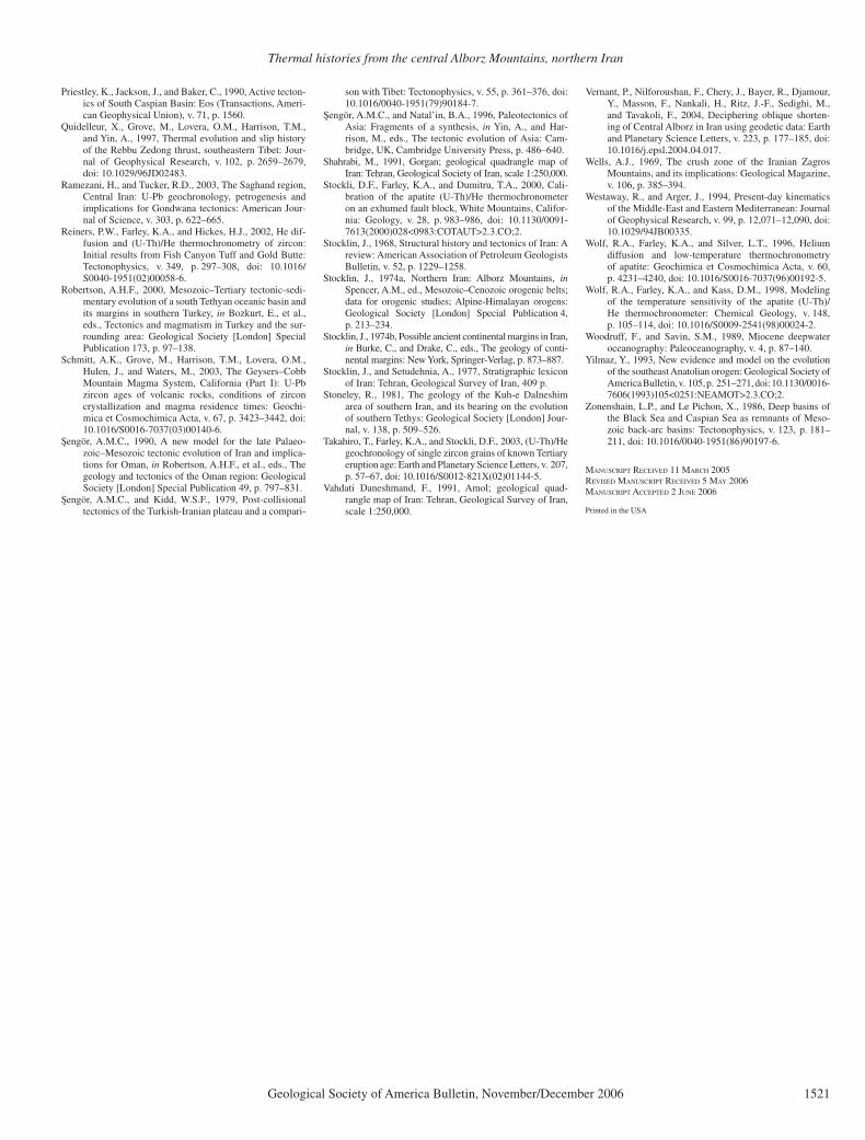
Thermal histories from the central Alborz Mountains, northern Iran
Geological Society of America Bulletin, November/December 2006 1521
Priestley, K., Jackson, J., and Baker, C., 1990, Active tecton-ics of South Caspian Basin: Eos (Transactions, Ameri-can Geophysical Union), v. 71, p. 1560.
Quidelleur, X., Grove, M., Lovera, O.M., Harrison, T.M., and Yin, A., 1997, Thermal evolution and slip history of the Rebbu Zedong thrust, southeastern Tibet: Jour-nal of Geophysical Research, v. 102, p. 2659–2679, doi: 10.1029/96JD02483.
Ramezani, H., and Tucker, R.D., 2003, The Saghand region, Central Iran: U-Pb geochronology, petrogenesis and implications for Gondwana tectonics: American Jour-nal of Science, v. 303, p. 622–665.
Reiners, P.W., Farley, K.A., and Hickes, H.J., 2002, He dif-fusion and (U-Th)/He thermochronometry of zircon: Initial results from Fish Canyon Tuff and Gold Butte: Tectonophysics, v. 349, p. 297–308, doi: 10.1016/S0040-1951(02)00058-6.
Robertson, A.H.F., 2000, Mesozoic–Tertiary tectonic-sedi-mentary evolution of a south Tethyan oceanic basin and its margins in southern Turkey, in Bozkurt, E., et al., eds., Tectonics and magmatism in Turkey and the sur-rounding area: Geological Society [London] Special Publication 173, p. 97–138.
Schmitt, A.K., Grove, M., Harrison, T.M., Lovera, O.M., Hulen, J., and Waters, M., 2003, The Geysers–Cobb Mountain Magma System, California (Part I): U-Pb zircon ages of volcanic rocks, conditions of zircon crystallization and magma residence times: Geochi-mica et Cosmochimica Acta, v. 67, p. 3423–3442, doi: 10.1016/S0016-7037(03)00140-6.
Sengör, A.M.C., 1990, A new model for the late Palaeo-zoic–Mesozoic tectonic evolution of Iran and implica-tions for Oman, in Robertson, A.H.F., et al., eds., The geology and tectonics of the Oman region: Geological Society [London] Special Publication 49, p. 797–831.
Sengör, A.M.C., and Kidd, W.S.F., 1979, Post-collisional tectonics of the Turkish-Iranian plateau and a compari-
son with Tibet: Tectonophysics, v. 55, p. 361–376, doi: 10.1016/0040-1951(79)90184-7.
Sengör, A.M.C., and Natal’in, B.A., 1996, Paleotectonics of Asia: Fragments of a synthesis, in Yin, A., and Har-rison, M., eds., The tectonic evolution of Asia: Cam-bridge, UK, Cambridge University Press, p. 486–640.
Shahrabi, M., 1991, Gorgan; geological quadrangle map of Iran: Tehran, Geological Society of Iran, scale 1:250,000.
Stockli, D.F., Farley, K.A., and Dumitru, T.A., 2000, Cali-bration of the apatite (U-Th)/He thermochronometer on an exhumed fault block, White Mountains, Califor-nia: Geology, v. 28, p. 983–986, doi: 10.1130/0091-7613(2000)028<0983:COTAUT>2.3.CO;2.
Stocklin, J., 1968, Structural history and tectonics of Iran: A review: American Association of Petroleum Geologists Bulletin, v. 52, p. 1229–1258.
Stocklin, J., 1974a, Northern Iran: Alborz Mountains, inSpencer, A.M., ed., Mesozoic–Cenozoic orogenic belts; data for orogenic studies; Alpine-Himalayan orogens: Geological Society [London] Special Publication 4, p. 213–234.
Stocklin, J., 1974b, Possible ancient continental margins in Iran, in Burke, C., and Drake, C., eds., The geology of conti-nental margins: New York, Springer-Verlag, p. 873–887.
Stocklin, J., and Setudehnia, A., 1977, Stratigraphic lexicon of Iran: Tehran, Geological Survey of Iran, 409 p.
Stoneley, R., 1981, The geology of the Kuh-e Dalneshim area of southern Iran, and its bearing on the evolution of southern Tethys: Geological Society [London] Jour-nal, v. 138, p. 509–526.
Takahiro, T., Farley, K.A., and Stockli, D.F., 2003, (U-Th)/He geochronology of single zircon grains of known Tertiary eruption age: Earth and Planetary Science Letters, v. 207, p. 57–67, doi: 10.1016/S0012-821X(02)01144-5.
Vahdati Daneshmand, F., 1991, Amol; geological quad-rangle map of Iran: Tehran, Geological Survey of Iran, scale 1:250,000.
Vernant, P., Nilforoushan, F., Chery, J., Bayer, R., Djamour, Y., Masson, F., Nankali, H., Ritz, J.-F., Sedighi, M., and Tavakoli, F., 2004, Deciphering oblique shorten-ing of Central Alborz in Iran using geodetic data: Earth and Planetary Science Letters, v. 223, p. 177–185, doi: 10.1016/j.epsl.2004.04.017.
Wells, A.J., 1969, The crush zone of the Iranian Zagros Mountains, and its implications: Geological Magazine, v. 106, p. 385–394.
Westaway, R., and Arger, J., 1994, Present-day kinematics of the Middle-East and Eastern Mediterranean: Journal of Geophysical Research, v. 99, p. 12,071–12,090, doi: 10.1029/94JB00335.
Wolf, R.A., Farley, K.A., and Silver, L.T., 1996, Helium diffusion and low-temperature thermochronometry of apatite: Geochimica et Cosmochimica Acta, v. 60, p. 4231–4240, doi: 10.1016/S0016-7037(96)00192-5.
Wolf, R.A., Farley, K.A., and Kass, D.M., 1998, Modeling of the temperature sensitivity of the apatite (U-Th)/He thermochronometer: Chemical Geology, v. 148, p. 105–114, doi: 10.1016/S0009-2541(98)00024-2.
Woodruff, F., and Savin, S.M., 1989, Miocene deepwater oceanography: Paleoceanography, v. 4, p. 87–140.
Yilmaz, Y., 1993, New evidence and model on the evolution of the southeast Anatolian orogen: Geological Society of America Bulletin, v. 105, p. 251–271, doi: 10.1130/0016-7606(1993)105<0251:NEAMOT>2.3.CO;2.
Zonenshain, L.P., and Le Pichon, X., 1986, Deep basins of the Black Sea and Caspian Sea as remnants of Meso-zoic back-arc basins: Tectonophysics, v. 123, p. 181–211, doi: 10.1016/0040-1951(86)90197-6.
MANUSCRIPT RECEIVED 11 MARCH 2005REVISED MANUSCRIPT RECEIVED 5 MAY 2006MANUSCRIPT ACCEPTED 2 JUNE 2006
Printed in the USA