the west midlands area multi-modal study
TRANSCRIPT

WMAMMSTRANSPORT STUDY
The West Midlands Area Multi-Modal Study
FINAL REPORT
Aspen Burrow CrockerIn association with
Transport Planning (International)Transport & Travel Research
Tony Young ConsultancyECOTEC
October 2001

October 2001
WEST MIDLANDS AREA MULTI-MODAL STUDY
Aspen Burrow Crocker in association with
Transportation Planning (International) Transport & Travel Research
Tony Young Consultancy ECOTEC
FINAL REPORT
Government Office for the West Midlands Department of the Environment Transport and the Regions 77 Paradise Circus Queensway Birmingham B1 2DT
Aspen Burrow Crocker Ltd Stratford Court Cranmore Boulevard Shirley Solihull West Midlands B90 4QT
Job Number Prepared by Approved by Status Issue Number Date 30537 JHB/JPW TM/LCD Final 01 15 October 2001

WEST MIDLANDS AREA MULTI-MODAL STUDY
FINAL REPORT
PREFACE


WEST MIDLANDS AREA MULTI-MODAL STUDY FINAL REPORT ____________________________________________________________________________________________________
October 2001
WEST MIDLANDS AREA MULTI-MODAL STUDY
FINAL REPORT
CONTENTS: 1.0 EXECUTIVE SUMMARY 1 2.0 BACKGROUND TO THE STUDY 23 3.0 TRANSPORT PROBLEMS AND RELATED ISSUES 26 4.0 STRATEGY AND PLAN IDENTIFICATION 40 5.0 PLAN DEVELOPMENT AND APPRAISAL 45 6.0 RECOMMENDED MODAL SCHEMES AND MEASURES 66 7.0 RECOMMENDED ECONOMIC INTERVENTION 80 8.0 RECOMMENDED BEHAVIOURAL CHANGE INITIATIVES 84 9.0 CONSULTATION 90 10.0 NATIONAL, REGIONAL AND LOCAL OBJECTIVES 101 11.0 ECONOMIC AND SOCIAL REGENERATION IMPACTS 112 12.0 IMPLEMENTING THE STRATEGY AND PLAN 118 APPENDICES: APPENDIX A – YEAR 2031 RECOMMENDED PLAN
NETWORK SCHEMATICS APPENDIX B – IMPLEMENTATION PROGRAMME APPENDIX C – REFERENCE CASE SCHEMES APPENDIX D – STEERING GROUP MEMBERS APPENDIX E – STUDY TERMS OF REFERENCE GLOSSARY OF ABBREVIATIONS

WEST MIDLANDS AREA MULTI-MODAL STUDY FINAL REPORT ____________________________________________________________________________________________________
October 2001
1
1.0 EXECUTIVE SUMMARY 1.1 BACKGROUND TO THE STUDY
Following the publication of the Integrated Transport White Paper – A New Deal for Transport in July 1998, a number of multi-modal studies were announced. These are intended to look at the total demand for travel over a comparatively long time period and to establish a thirty- year framework that would provide for an integrated transport system covering all modes, including the more sustainable means of travel such as walking and cycling. The Study Area for the West Midlands Area Multi-Modal Study (WMAMMS) is shown in Figure 1.1. It includes an area outside the six Metropolitan Districts extending into the surrounding Shire Counties which are also part of the Study, but only insofar as it is necessary to look at their relationship, in transport terms, to the conurbation. The aim of the Study is to investigate and seek solutions to problems on or with all modes of surface transport. A large number of options comprising behavioural, economic and modal interventions have been developed and appraised. The appraisals have been undertaken to determine the effectiveness of the various options against National, Regional, Local and Specific Locational Objectives. Apart from the national objectives of integration, economy, safety, accessibility and environment, the primary aim of the Study was derived from a vision suggested by the West Midlands Regional Forum of Local Authorities. “to create a safe, modern, efficient and cohesive network of integrated transport facilities and services throughout the Study Area which serves the accessibility and mobility needs of both individuals and the business community in an environmentally friendly manner.”
The Study was undertaken by a consortium of consultants led by Aspen Burrow Crocker Ltd and managed by a Steering Group chaired by the Government Office for the West Midlands. The Study began in December 1999 and this report is the final output.
1.2 THE TRANSPORT IN THE STUDY AREA – PROBLEMS AND ISSUES 1.2.1 The Transport System
Within the Study Area, delays due to congestion on the Midlands “Motorway Box” have gained national notoriety and are said to affect business confidence as far away as Scotland and the North-West of England. On the non-motorway network, congestion is particularly apparent in Birmingham City Centre, and other centres and environs at Wolverhampton, Dudley, Walsall, West Bromwich, Solihull and Halesowen. All radial approaches to Birmingham City Centre suffer severe congestion at peak periods near to the city centre and at their junctions with the motorway system. Traffic growth on much of the primary route network in the central areas of the conurbation has slowed to less than 1% per annum (daily flows), due to the limiting factor of congestion. Conditions on the motorways are rapidly becoming similar except that the effects of flow breakdown are more severe, with longer queues, due to the lack of alternative routes. New information systems such as variable message signs and RDS traffic information are helpful in providing early warning of delays, but the motoring public still has to acquire confidence in them. For all vehicles travelling on the road network including private cars, public transport vehicles and commercial traffic, the cost of congestion is increasing as more of the network becomes overloaded and congestion spreads into off-peak periods. Pressures on the network result in traffic using unsuitable routes, road traffic casualties and problems for vulnerable road users, unreliable and delayed bus services, delays to commercial traffic and environmental degradation.

WEST MIDLANDS AREA MULTI-MODAL STUDY FINAL REPORT ____________________________________________________________________________________________________
October 2001
2
Figure 1.1: The Study Area The road network in the west of the conurbation has a variable, often poor, mixture of standards and lacks a clearly defined hierarchy. The business community maintain that regeneration of the south and west of the Black Country area has been limited by the absence of good road communications. This is evidenced by lower development land values and commercial rents. In terms of structural road integrity, the National Road Maintenance Condition Survey has shown that roads in the West Midlands are probably in a worse condition than anywhere else in the country. Structural maintenance provision is a concern to the local highway authorities and road users alike. A lack of investment has historically led to a decline in the condition of the West Midlands road network. Inadequate maintenance causes particular problems to the slow modes, walking and cycling, where uneven surfaces are a particular hazard.

WEST MIDLANDS AREA MULTI-MODAL STUDY FINAL REPORT ____________________________________________________________________________________________________
October 2001
3
Bus and coach travel is the backbone of public transport in the conurbation and will remain so for the foreseeable future. No data is available on the reliability of bus services but road congestion causes slow journey times and unreliability. Other perceived problems are poor access to the network, lack of integration, uncomfortable seating, infrequent services in the evenings and weekends and a general lack of information. The relevant authorities are well aware of these issues and steps are being taken to improve the situation, but a step change in the investment will be required to deliver the quality of service envisaged in the transport vision. The rail system is an important part of the local transport network and Birmingham New Street is a major hub on the national rail network. Mirroring the situation on the motorway network, major rail capacity problems exist at Birmingham New Street station, and on the Wolverhampton – Birmingham – Coventry - Rugby, Cross-City, Coventry-Leamington, and Snow Hill-Leamington lines. Capacity problems also exist at other stations, particularly Wolverhampton and Walsall. There is overcrowding on some routes at peak times, rail services are perceived as unreliable and there is inadequate ‘Park and Ride’ capacity at some stations. The first Midland Metro line between Wolverhampton and Birmingham began operating in May 1999. Initial technical problems affected both service frequency and reliability. Although very popular, patronage is below forecast at present. The location of Birmingham Snow Hill terminal limits its attractiveness for some journeys. The location of the Wolverhampton terminal does not afford easy interchange with buses or trains and delays occur on the street running section in Wolverhampton which adversely affect reliability. On the eastern side of the conurbation the rapid and continuing expansion of Birmingham International Airport presents surface access problems across all modes. The potential scale of growth will require major investment in new infrastructure, both externally and within the airport complex. Cycle usage accounts for around 2% and walking 26% of all trips in the conurbation. There is nominally an extensive local cycle network in each of the local authorities, however in most cases these facilities are not of a standard which is likely to encourage cycle usage. Achievement of current Government targets looks unlikely without a major change in behaviour and significant investment in improved facilities.
1.2.2 Environmental Issues
Transport-related degradation of the environment in the conurbation takes the usual form of air pollution, noise and visual intrusion. All of these are strongly related to road traffic volumes and congestion, and are widespread across the area, particularly at peak periods. If the objectives of the Study are met, substantial mitigation of these adverse effects, particularly those caused by road traffic, will be achieved.
1.2.3 Socio-Economic Issues
The most obvious aspect of the Study Area’s economic problems is the above average unemployment rates which have persisted following the ‘demand shocks’ of the 1979-81 and 1989-92 recessions. These are concentrated in the areas of the Black Country and Birmingham which were most dependent on manufacturing. Very often these problems are accompanied by other facets of ‘joblessness’ such as low economic activity rates and concentrations of attendant health and social problems.
The area has made a major effort – and has had significant successes – in diversifying into service activities and higher value added sectors more generally, in part through attracting mobile domestic and foreign direct investment. However, as discussed further below, this investment appears to have been constrained and shaped to a substantial extent by transport-related issues.

WEST MIDLANDS AREA MULTI-MODAL STUDY FINAL REPORT ____________________________________________________________________________________________________
October 2001
4
1.2.4 The Influence of Transport on Regeneration
Work for SACTRA highlighted that good transport access is not always necessary and is never a sufficient condition for development and regeneration to occur. Nevertheless, the Regional Economic Strategy highlights the “....major traffic problems at certain points in the region.” And argues that, “If these are sorted out, it will help improve the development of the region”. It is not possible to accurately quantify the influence of transport on regeneration and economic development. However, the least accessible parts of the conurbation (in relation to external markets) are those which show the lowest commercial rental and land values. The Study has identified six key transport issues that appear to constrain economic development or regeneration in the Study Area:
• Congestion problems on the M6; • Lack of good access to the southern Black Country; • Lack of access to the west side of the conurbation; • Peak period congestion on the M42 corridor; • Access to the main urban centres, particularly Birmingham City Centre; and • Social exclusion to employment opportunities due to inadequate public transport.
1.3 DEVELOPING A STRATEGY 1.3.1 The Process
Transport is a derived demand and the decision to make a journey and the characteristics of that journey such as destination, mode of travel, time of departure are governed by four main influences or ‘drivers’. These are economic, land use, behaviour and modal characteristics. By changing one of these four parameters the way some journeys are made will change.
Economic Intervention
Modal Measures Behavioural Change
Land Use Policies
changing the cost of travel
changing the transport network
changing travel choices
changing the need to travel
Figure 1.2 The Strategy Development Process
Reference CaseTravel Demand
Strategy Options
Institutional Change
Chosen Strategy

WEST MIDLANDS AREA MULTI-MODAL STUDY FINAL REPORT ____________________________________________________________________________________________________
October 2001
5
Development of a genuinely strategic approach to transport provision has been difficult to achieve in previous studies because of the problems of estimating the total demand for travel by all modes. In this Study, the strategy development process was able start from a total number of trips which need to be accommodated. By changing the relative influence of the drivers of change, the number of trips by each mode is changed and an optimum strategy can be developed which satisfies both national and local objectives. The approach used in the Study for the development of an overall strategy is illustrated in a simplified form in Figure 1.2.
In summary the process begins with the definition of a Reference Case, which encompasses the forecast demand for travel by the various modes given the continuation of present trends in transport provision, travel costs and behaviour. This is followed by an examination of the main effect of interventions under the four identified Drivers of Change, i.e. Economic, Modal, Behavioural and Land Use. A number of Sensitivity Tests then follow to assess the effect of more extreme interventions to each of the drivers.
1.3.2 The Elements of A Strategy The Reference Case is designed to indicate future conditions if levels of investment and changes in behaviour and economic trends are generally in line with current conditions. It acts as the base against which strategy and plan options are assessed. The make-up of the Reference Case has been based on the current Local Transport Plan, Centro’s 20 Year Plan, investment proposals by SRA/Railtrack, the Highways Agency (including the privately funding Birmingham Northern Relief Road) and other known proposals. A Strategy Option can be created by changing the level of intervention of one or more of the ‘drivers’ as follows:
• Behavioural Change – this intervention seeks to change attitudes and hence travel behaviour to encourage travel by more sustainable modes, shorter journeys, linked journeys for more than one purpose, etc.
• Economic Instruments – the cost of travel represents a strong influence on the
choice of mode. By reducing the perceived differential between using a car and public transport, more people will travel by the sustainable modes. Because much of the cost of car travel is fixed and prepaid, it will be necessary to change car travel costs to ‘point of use’ charges.
• Modal Measures – these include all the physical infrastructure changes to the
transport system, roads and public transport, that require investment to effect an improvement.
• Land Use Polices – the interventions under this driver aim to reduce the need for
travel by changing the spatial location of transport generators such as housing, employment, shopping and other large developments.
In consultation with the Study Team, the West Midlands Local Government Association considered three options for population distribution for the Land Use driver and recommended that the Study should adopt the assumption that the historic drift of population out of the conurbation could be halted.

WEST MIDLANDS AREA MULTI-MODAL STUDY FINAL REPORT ____________________________________________________________________________________________________
October 2001
6
Behavioural
Change
Im plem ented
Strategy
Econom ic
M easures
M odal
Im provem ents
Relieves congested
networks
Improved public transport
encourages behavioural
change
Raises
aware
ness
of tr
ue
cost
of tr
ansp
ort c
hoice
sRoa
d pric
ing e
ncou
rage
s
beha
viou
ral c
hang
e
Funding generated for transport im provem ents
Public transport im provem ents provide viable alternatives to paying
road user charges
Some examples of how the effects of the remaining three drivers are inter-related are illustrated in Figure 1.3 below. Initially these effects were assessed individually and collectively using moderate levels of intervention which, on the basis of best judgement, were thought to be achievable in the short to medium term. A more extreme level of intervention in each driver was then used as a sensitivity test and each combination assessed against the Study objectives.
Figure 1.3 The Inter-relationship of ‘Drivers of Change’ 1.3.3 Towards a Preferred Strategy
The strategy option phase of the Study confirmed that a strategy focussed on a single ‘driver of change’ or, in the case of the modal driver, a single mode be it walk/cycle, roads, bus, Metro or heavy rail would not achieve the Study Objectives. A balance needs to be achieved across all modes, building on the strengths of each mode, but investment in transport infrastructure alone will not be sufficient. Viable modal improvements will need to be underpinned by significant behavioural changes and economic measures to influence such changes. In particular, if the aims of the Ten Year Plan for Transport such as reducing congestion levels, are going to be achieved within a realistic funding regime, all three drivers have to be incorporated within the strategy. Consideration of the appraisal of strategy options led to the identification of the combination of options which appeared to best meet the Regional and Local Objectives in the short and longer term. The probable levels of intervention required in the four ‘drivers’ of change to achieve the Objectives are summarised in Table 1.1.

WEST MIDLANDS AREA MULTI-MODAL STUDY FINAL REPORT ____________________________________________________________________________________________________
October 2001
7
Table 1.1 - Strategic Intervention Levels
‘Drivers’ of Change Short Term (2011) Long Term (2031)
Behavioural Change
5% reduction in car trips*
10% reduction in car trips*
Economic Instruments
Reduce differential between car and public transport travel costs
Equalise car and public transport travel costs.
Modal Measures
Moderate intervention in all modes
Moderate to high intervention in all modes
Land Use
Halt current population drift
Halt current population drift
* in addition to the 5% reduction in car trips included in the Reference Case
1.4 PLAN DEVELOPMENT AND APPRAISAL The Audit Phase of the Study examined current and future transport networks and problems
in the Study Area. During this phase the Study team carried out a detailed review of local transport objectives and assessed current and future problems and opportunities. The wide range of proposed schemes and measures identified in the West Midlands and Shire Counties Local Transport Plans together with current programmes from Centro, Railtrack and the Highways Agency were included in the modal interventions considered in the subsequent phases of the Study. During both the Strategy and Plan Development Phases, consultations continued with members of the Study Steering Group and sub-groups, and the Wider Reference Group. The membership of these groups included representatives of transport authorities and operators, environmental groups, business and freight interests and others. From these consultations and other work by the Study Team, previously identified problems and their causes were examined further and possible solutions developed. In particular the interactions of problems and proposed solutions for individual transport modes were considered.
Many of the potential improvements and changes considered in the Plan Development Phase are already well known, and often tried and tested. They may include better information systems, high quality public transport, improved junctions, better highway maintenance, persuading people to use cars less, etc. Very few changes in transport provision are likely to be radical, but there will be some. These could involve ‘high-tech’ approaches to control of speed (to improve safety) and electronic linking of vehicles (to improve safety and road capacity). These measures are not expected to be in universal use until the second half of the plan period because of the infrastructure required and the need to equip most vehicles with the necessary equipment. The Plan Development process has therefore had to take into account changes that are already available and some that are still being developed. The process broadly covered possible plan options for the following sub-areas as well as area-wide schemes, measures and initiatives: • The western conurbation including the Black Country; • The central conurbation around Birmingham; • The eastern side of the Study Area including the M42 corridor.
The Plan Option Appraisal process was based on the Guidance on Methodology for Multi-Modal Studies (GOMMMS) issued by DETR in March 2000. The approach adopted worked within the appraisal framework provided by the five Government objectives for transport of

WEST MIDLANDS AREA MULTI-MODAL STUDY FINAL REPORT ____________________________________________________________________________________________________
October 2001
8
environment, safety, economy accessibility and integration. This approach is geared to three purposes: • choosing between different options for solving the problem; • prioritising between proposals; and • assessing value for money.
The process relied on the use of full or partial Appraisal Summary Tables for elements and layers of the Plan together with an assessment of performance against Regional and Local Objectives. Plan options were explicitly modelled as far as possible using a Strategic Transportation Model (STM) to assess the operational performance of each package. Outputs from the STM were input into the TUBA (Transport User Benefit Assessment) computer programme to determine transport economic efficiency on a multi-modal basis.
1.5 A SUMMARY OF THE 2031 PLAN The development of the 2031 Plan from the identified outline Strategy involved the package
testing of over 150 different scheme suggestions many of which came from Local Authorities, special interest groups, Centro, and Government Agencies in addition to the Study Team. The recommended plan incorporates modal investment, behavioural change targets and economic measures which when implemented will deliver the selected strategy and achieve the transport vision.
1.5.1 Modal Measures
Bus Transport Bus travel will remain the most important and dominant public transport mode in the Study Area and the proposed improvements are designed to raise its share of the peak travel usage from one-fifth in 1999 to nearly one-third by 2031. Improvements required will involve ‘Showcase’ type improvements on all strategic routes with significant priority on routes with heavy passenger loading designed to achieve a journey time equivalent to 95% of car speeds at peak periods. Bus Priority will need to be virtually continuous through most important junctions and if road space is not to be reduced for other vehicles, widening will be required. These routes will be designated Super Showcase Routes. The schematic bus network is illustrated in Fig 1.4 . Rail Transport
The recommended 2031 light rail (Metro) network, shown schematically Fig. 1.5, consists of the following ten routes, mainly centred on Birmingham, Wolverhampton and Walsall (these are in addition to Midland Metro Line One and the currently planned extensions to Five Ways and Brierly Hill) :-
• Birmingham to Walsall • Birmingham to BIA via Chelmsley Wood • Birmingham to BIA via Sheldon • Birmingham to Shirley – Solihull • Birmingham to Moseley – Kings Heath – Maypole • Birmingham to Northfield • Birmingham to Quinton – Halesowen (with possible branches to Bartley Green and
Londonderry) • Walsall to Wednesbury • Walsall to Wolverhampton • Wolverhampton to Dudley
The two routes in East Birmingham to BIA, via Chelmsley Wood and Sheldon, would be connected into a loop to form a continuous route.

WEST MIDLANDS AREA MULTI-MODAL STUDY FINAL REPORT ____________________________________________________________________________________________________
October 2001
9
The major heavy rail innovation in the 2031 Plan is the introduction of a Regional Express
Rail Network (RER). The RER concept, characterised by high performance, high quality vehicles and infrastructure, would provide an integrated modern rail system that would connect towns and cities within and around the edge of the conurbation with central Birmingham. The schematic heavy rail network, as illustrated in Fig. 1.5, has been discussed with all the major rail industry partners, including the SRA, Railtrack and Centro and the appraisal process has indicated that there would be economic and operational benefits delivered by developing such a network. The RER system would include services that continue through the centre providing cross-conurbation links operating on the following lines :- • Coventry – Birmingham – Wolverhampton • Cannock – Walsall – Birmingham – Nuneaton • Lichfield – Birmingham – Redditch • Tamworth – Birmingham – Worcester • Leamington Spa/Warwick – Birmingham – Kidderminster • Walsall - Birmingham – Shirley – Stratford
Depending on viable passenger demand, services could also be extended to other centres such as Telford, Shrewsbury, Stafford and Rugby. The development of a series of major ‘strategic’ Park and Ride sites is suggested, mainly on the edge of the conurbation, to operate in conjunction with the RER.
The following major heavy rail schemes are identified as part of the 2031 Plan. These
schemes, though essential for the full implementation of the RER, would also have major benefits to longer distance, through rail services.
Birmingham New Street: new Underground Station and Tunnels
Four-tracking West Coast Main Line (WCML), Coventry to Wolverhampton Four-tracking Birmingham to Water Orton
A further three schemes are included in the 2031 Plan which would enable freight diversion away from the central Birmingham rail network:-.
Electrification Walsall – Rugeley Electrification Nuneaton – Walsall via Sutton Park Re-open Stourbridge – Walsall – Lichfield Line (Freight only)
Highway Network
As a result of the appraisal process, the following key highway components, as illustrated in the schematic highway network shown in Fig. 1.4, have been identified for the 2031 Plan:- • The M5/M6 corridor should retain a role as the north-south strategic route for long
distance through traffic; • A link should be provided between the M54 and the M6/Birmingham Northern Relief
Road to improve access to and from the M54; • Western Bypasses of Wolverhampton and Stourbridge, coupled with strengthening of
the road hierarchy in the Black Country, to improve access and assist regeneration. • Widening of the M42 between Junctions 3 and 7 together with junction improvements is
necessary to accommodate the projected growth in this corridor. The widening should be designed to provide a continuous dual four-lane carriageway with an additional lane between junctions;
• The introduction of Active Traffic Management (ATM) on the existing motorway ‘box’ to make best use of existing routes; and
• The introduction of ‘Red Route’ and local highway capacity improvements mainly to facilitate public transport priorities both for Super Showcase bus and LRT.

WEST MIDLANDS AREA MULTI-MODAL STUDY FINAL REPORT ____________________________________________________________________________________________________
October 2001
10
Figure 1.4: Bus and Highway Schematic Networks

WEST MIDLANDS AREA MULTI-MODAL STUDY FINAL REPORT ____________________________________________________________________________________________________
October 2001
11
Figure 1.5: Heavy Rail and Light Rail (Metro) Schematic Networks

WEST MIDLANDS AREA MULTI-MODAL STUDY FINAL REPORT ____________________________________________________________________________________________________
October 2001
12
1.5.2 Economic Intervention
In terms of the overall objectives of the Study, road user charging, in the form of cordon or area based congestion charging or ultimately full electronic road pricing, appears to offer greater flexibility and mode shift potential than other possible economic interventions. This is not to rule out such measures as lower bus fares, workplace parking levies, or motorway slip-road tolling which may have a role to play in the shorter term.
A key part of the Strategy and Plan is the introduction of road user charges to bring the
perceived cost of travel by car nearer to public transport travel costs. In the medium to long term the introduction of full electronic road pricing is recommended and this would need to be delivered at regional, if not national, level. In the shorter term, it is anticipated that congestion charging schemes could be gradually introduced based on cordons around the major centres in the conurbation, possibly starting with Birmingham City centre. The responsibility for implementing such schemes would rest with the individual Metropolitan Councils but an integrated approach across the area would be desirable.
1.5.3 Behavioural Change
The primary goal of this element of the strategy is to develop the role of ‘hearts and minds’ measures to encourage sustainable travel behaviour. The challenge is to change travel habits in favour of alternative modes to the private car such that people use their cars less and travel in a more sustainable way.
The assessment of current and future initiatives revealed how travel behaviour programmes
have been developed throughout the West Midlands. However, these are not co-ordinated, and suffer from a lack of continuity. Travel Awareness initiatives are generally planned at district level, although Centro has promoted some wider initiatives, and is often a partner at a local level. Current programmes would achieve a modest change in travel behaviour and it is believed that these existing initiatives cost in the order of £1m per annum over the whole conurbation. In view of the major economic and social benefits which will potentially accrue from such initiatives, it is recommended that resources for behavioural change should be substantially increased to at least £5m per annum.
As a complementary measure in encouraging behavioural change it is also recommended that expenditure across the Study Area on improving walking and cycling facilities is increased from the current level of £4m to £10m per annum.
1.6 KEY TRANSPORT FORECASTS
Demand for person movement in the Study Area, over the thirty-year period, increases from nearly 2.5 billion trips per annum to over 3.1 billion, an increase of almost 27%. Regardless of how people travel this change presents a significant challenge. Table 1.2 compares the Base Year and Reference Case with the situation if the component modal, economic and behavioural measures of the 2031 Plan are implemented. Implementation of the full strategy in respect of modal, economic and behavioural measures limits the total number of person trips by road vehicle in 2031 to close to 1999 base year levels both in the am peak hour and in terms of total annual trips. The reduction in occupant mileage by road vehicle (excluding bus) compared with the Reference Case is not so marked because the reduction in levels of road congestion leads to an increase in average trip length in the model. The behavioural and economic measures tend to counter this trend.

WEST MIDLANDS AREA MULTI-MODAL STUDY FINAL REPORT ____________________________________________________________________________________________________
October 2001
13
Table 1.2 - Travel Forecasts by Mode
1999
B
ase
Year
2031
Ref
eren
ce
Cas
e
2031
Pla
n M
odal
M
easu
res
Onl
y
2031
Pla
n M
odal
& E
cono
mic
M
easu
res
2031
Pla
n M
odal
& E
cono
mic
M
easu
res
and
Beh
avio
ur C
hang
e
Million trips per annum (% change from Reference Case)
Road Vehicles (except Bus) 1,923 2,324 2,245 (-3.4%)
2,222 (-4.4%)
2037 (-12.3%)
Bus 493 727 721 (-0.8%)
735 (1.1%)
920 (26.5%)
Rail (Heavy and Light) 41 61 146 (139.3%
155 (154.1%)
155 (154.1%)
Total 2,457 3,112 3,112 3,112 3,112 Million occupant-km pa (%Change from Reference Case)
Road Vehicles (except Bus) 34,871 40,168 39,443 (-1.8%)
38,661 (-3.8%)
36,646 (-8.8%)
Bus 3,373 4,466 4,702 (5.3%)
4,708 (5.4%)
5,718 (28.0%)
1,870 2,329 4,037 (73.3%)
4,277 (83.6%)
4,246 (82.3%)
Modal Split Road -
AM Peak Hour Trips Modal split in AM Peak Hr
475,000 76.0%
573,000 71.5%
547,000 67.6%
534,000 65.6%
481,000 60.2%
Bus - AM Peak Hour Trips
Modal split in AM Peak Hr
135,000 21.6%
203,000 25.3%
207,000 25.6%
218,000 26.7%
255,000 31.9%
Rail (Heavy and Light) - AM Peak Hour Trips
Modal split in AM Peak Hr
15,000 2.4%
25,000 3.2%
55,000 6.8%
63,000 7.8%
63,000 7.9%
1.7 INVESTMENT COSTS
The broad investment costs of the 2031 Plan over the 30-year implementation period are shown in Table 1.3 and these total £7.67bn at year 2000 prices. This is in addition to the investment required for the Reference Case, which is estimated to cost approximately £2bn over the same period. The bulk of the investment, (approximately 80%) is in respect of public transport networks but it should be noted that this includes substantial expenditure, in the order of £2.6bn for ‘national’ heavy rail schemes at Birmingham New Street and the four-tracking of the Coventry – Birmingham – Wolverhampton main line.

WEST MIDLANDS AREA MULTI-MODAL STUDY FINAL REPORT ____________________________________________________________________________________________________
October 2001
14
Table 1.3 - Estimated Investment Costs: Recommended 2031 Plan
2031 Plan Component
2031 Plan Investment
Costs in Current Prices (£million)
Modal Measures Heavy Rail/RER Network Light Rail Network Showcase Bus Network Highway Network Economic Intervention Road User Charging Systems Behavioural Initiatives* Changing Travel Behaviour
4,180 1,483 500
1,052
120
335
Total Investment Costs 7,670 * includes investment in walking and cycling facilities
1.8 ECONOMIC BENEFITS The transport economic efficiency of the Plan components are summarised below. The
analyses are based on the use of the TUBA software over the period 2001 to 2051 using two modelled years, 2011 and 2031. The 2011 scenario includes all schemes likely to be in place by that date whilst the 2031 scenario includes all of the Plan elements. The benefits and costs indicated are at year 2000 prices discounted to 2000 at a discount rate of 6%. Table 1.4 - Summary of Economic Evaluation
Economic Impacts
2031 Plan Modal Measures Only
2031 plan Modal plus Economic
Measures
2031 Plan Modal Plus Economic Measures and Behavioural
Change Net Present Value NPV £2.7bn £3.4bn £5.4bn Present Value of Costs, PVC -£5.5bn -£5.7bn -£5.8bn Present Value of Cost to Government -£4.5bn -£2.7bn -£2.7bn Benefit/Cost Ratio, BCR 1.49 1.60 1.92 Value/Cost to Government Ratio, VCGR 0.59 1.27 1.99
1.9 CONSULTATION 1.9.1 Consultation Activities
Extensive consultation was undertaken throughout the Study covering problem identification, strategy and plan options and recommendations. Specific activities have included: • Focus Groups; • Structured Questionnaire Survey; • Informal Questionnaire in Study Leaflet; • Wider Reference Group Meetings; • Meetings with Special Interest Groups; • Attendance at LTP Consultation Events; • Presentation to MEPs, MPs and local elected Members; and • Radio Interviews

WEST MIDLANDS AREA MULTI-MODAL STUDY FINAL REPORT ____________________________________________________________________________________________________
October 2001
15
The final consultation stage involved a questionnaire on the plan recommendations sent to a randomly selected sample of 10,000 people. A response exceeding 2,500 indicated strong support for virtually all the recommendations.
1.9.2 Key Consultation Conclusions The consultation phase of WMAMMS has identified a number of key conclusions which are as follows:
• Before the Study was initiated there was no multi-modal consultation covering the transport sector across the West Midlands.
• A wide-ranging consultation involving focus groups, questionnaires and group
discussions has been undertaken throughout the life of the Study. This has been supported by dissemination activities through the local media. Special efforts have been made to ensure the participation of groups who might otherwise be excluded from consultation exercises.
• A range of key stakeholders, including representatives of the business community
and environmental activists as well as local authorities and public transport operators, were consulted throughout the Study.
• There is a broad level of support for the 2031 Plan, but it is readily apparent that,
whilst some measures are strongly supported, others have attracted less support, possibly due to the lack of detailed proposals at this stage.
• A number of measures did not attract public support. Whilst this is unsurprising in the
case of concepts such as road user charging, the importance of such a measure to the success of the overall 2031 plan means that further work to build public acceptance by explaining the links between road user charging and investment will be essential.
The scope of this Study was very wide and, as such, the range of issues to be considered during consultation was highly complex whilst the level of detail which could be supplied was, of necessity, restricted. Whilst the consultation undertaken to date provides comfort that the approach proposed in the 2031 Plan is in line with public opinion, it does not signify public approval for the individual components of the Plan.
1.10 EFFECT ON THE ENVIRONMENT
It is likely that any new infrastructure will have an adverse effect on the environment. Four tracking of the heavy rail line between Coventry and Wolverhampton, widening of the M42 and the western bypasses of Stourbridge and Wolverhampton are examples. However, if the recommended Strategy and Plan is implemented, substantial environmental gains will be achieved over the conurbation as a whole. A summary of the principal quantitative changes, relative to the Reference Case, is shown below in Table 1.5 and the full Appraisal Summary Table can be found at Table 1.6.
1.10.1 Road Usage and Congestion Delay With the implementation of the Plan, average delays due to congestion within the conurbation will decrease and should reduce to below existing levels. This reduction in congestion, one of the targets of the Government’s 10 Year Plan, will help in developing a more environmentally friendly transport system. It will also enable buses and road-based Metro vehicles to operate more efficiently with improved journey time reliability. The 2031 Plan produces an overall 8.9% decrease in total road vehicle kilometres, made up of a 15% reduction on the non-motorway network and a 2.1% decrease on the motorways in the area. This alone will give a reduction in traffic emissions and a slight decrease in noise across the Study Area with the urban centres benefiting most.

WEST MIDLANDS AREA MULTI-MODAL STUDY FINAL REPORT ____________________________________________________________________________________________________
October 2001
16
1.10.2 Air Quality Area-wide, the effect of the 2031 Plan is to reduce emissions of Nitrogen Dioxide (NO2) by 460 tonnes/annum and Airborne Particles (PM10) by 20 tonnes/annum. Greenhouse gas emissions would also reduce as a result of the 2031 Plan measures, giving a reduction in the emission of CO2 by 375,000 tonnes/annum. These forecasts take into account reductions in vehicle emissions in 2031 due to predicted advances in clean engine technology.
1.10.3 Public Transport Usage
Public transport patronage under the 2031 Plan will increase significantly, with a significant shift away from the use of the car compared with the Reference Case. Total rail patronage, in terms of passenger kilometres travelled for both heavy rail and Metro, will almost double. Modal share by rail in the am peak, in terms of total trips, will increase to 7.9% compared with the 2031 Reference Case share of 3.2%. Modal share by bus in the am peak will increase from 25.3% in the Reference Case to 31.9%. Overall bus passenger kilometres travelled will increase by around 30%. However, bus services will still carry six times as many passengers as rail.
1.10.4 Road Safety
Road accidents are predicted to decrease by 14%, with an estimated 35 fewer fatalities in 2031. This reduction will be a significant contribution to the Government’s 10 Year Plan target for accident reduction. The improved facilities for pedestrians and cyclists recommended as part of the 2031 Plan will incorporate measures to improve safety for vulnerable road users. Table 1.5 - Key Environmental Indicators Relative to the Reference Case 2031 Plan Modal
Measures Only 2031 Plan Modal,
Economic & Behavioural Measures
Road usage (vehicle-kilometres per annum)
- 1.8%
- 8.9%
Congestion delay Change in vehicle-hrs per annum (%age reduction)
- 24.3 million
(16% reduction)
- 60.5 million
(40% reduction) Air Quality: NO2
PM10 CO2
- 93 tonnes/annum - 4 tonnes/annum
- 76,000 tonnes/annum
- 460 tonnes/annum - 20 tonnes/annum
- 375,000 tonnes/annum Public Transport usage (passenger kilometres per annum)
‘bus rail
+ 5.3% + 73.3%
+ 28.0% + 82.3%
Road Accidents - 4.4% - 14%

WEST MIDLANDS AREA MULTI-MODAL STUDY
October 2001
17
TABLE 1.6 Appraisal Summary Table – Recommended 2031 Plan (Modal, Economic and Behavioural Change Measures) Option
2031 Plan including Modal, Economic and Behavioural Change Measures.
Description: Package comprising: 14 no. heavy rail schemes incl. Regional Express Rail network 12 no. Park and Ride Sites 13 no. light rail schemes 15 no. cross border showcase bus routes + showcase bus priority measures on all routes 25 no. highway improvements schemes Increased walking/cycling provision, Electronic Road Pricing and Behavioural Change Measures.
Problems Refer to Chapter 3 for Summary of Transport-related Problems
Present Value Cost To Government £2.701 bn
OBJECTIVE SUB-OBJECTIVE QUALITATIVE IMPACTS
QUANTITATIVE MEASURE ASSESSMENT
ENVIRONMENT
Noise Local Air Quality Greenhouse Gases
Decrease in total road vehicle kilometres will give a very slight decrease in noise across the Study Area. Notwithstanding mitigation some significant noise increases will be experienced arising from new highway routes. The greatest impact will be on the west side where approximately 300-400 houses could be significantly adversely affected by the Stourbridge and Wolverhampton Western Bypasses. Four-tracking of the WCML (between Wolverhampton and Coventry via Birmingham) will have noise impacts dependent on scheme details to be determined. Slight worsening of air quality will occur around new road schemes but overall there will be a slight improvement within the conurbation due to reduced road traffic. A slight reduction in greenhouse gases produced within the Study Area will occur.
Possibly 500-1000 houses could be significantly adversely affected by noise (i.e. >3dB(A) increase). Reductions in emissions: NO2 460 Tonnes/yr PM10 _ 20 Tonnes/yr CO2 375,000 Tonnes/yr
Landscape Most light rail, heavy rail and highway schemes will have an adverse impact, generally slight or moderate. However four-tracking of the West Coast Main Line (between Wolverhampton and Coventry via Birmingham), the Western Bypasses of Wolverhampton and Stourbridge and the highway links between the M54 and the Birmingham Northern Relief Road and between the A449 and the Dudley Southern Bypass are assessed as having large adverse impacts.
5 No. schemes large adverse; 11 No. moderate adverse; Remainder slight adverse or neutral
Large Adverse
Townscape Heavy rail four-tracking, light rail and most highway schemes will have a slight or moderate impact.
9 Schemes moderate adverse; Remainder slight adverse or neutral
Moderate Adverse
Heritage of Historic Resources
Most heavy rail, some light rail and most highway schemes will have a slight or moderate adverse impact. 6 Schemes moderate adverse; Remainder slight adverse or neutral
Moderate Adverse
Biodiversity Most heavy rail, light rail and highway schemes will have a slight or moderate adverse impact. The Birmingham International Connection rail scheme will have a large adverse impact.
1 Scheme large adverse 13 Schemes moderate adverse Remainder slight adverse or neutral
Large Adverse
Water Environment Most schemes will enable improvements through incorporation of Sustainable Development principles and run-off treatments but some heavy rail, light rail and highway schemes will have a slight adverse impact. The Birmingham International Connection rail scheme will have a large adverse impact on water quality objectives.
1 Scheme large adverse; 20 Schemes slight adverse; Other schemes neutral.
Large Adverse
Physical Fitness All public transport schemes will include an element of walk/cycling. Walking and cycling schemes will give a significant increase in walking/cycling from current level of about 26% and 2% of all trips. Further behavioural change measures including pedestrian and cycle facilities should encourage further modal shift to walking and cycling particularly for short trips including access to bus and rail services.
Target is for cycling trips to increase from approx. 2% to 10% of all trips. Distance walked likely to increase due to increased public transport usage -approx. 30% on a 24hr basis
Large beneficial
Journey Ambience Bus improvements provide moderate beneficial impact. RER and LRT Metro schemes provide large beneficial impact. Western Bypasses will give further beneficial impacts on the West side of the Conurbation due to the use of less congested roads designed to current standards.
Impacts: 19 Schemes large beneficial; 22 Schemes moderate beneficial; Remainder slight beneficial or neutral
Large beneficial
SAFETY
Accidents Security
The Plan will reduce accident numbers primarily due to the reduction in annual road vehicle kms. Public transport improvements will afford increased security to users.
Estimated annual reduction of 35 fatalities, 349 serious, and 1786 slight accidents.
£80million annual benefits (Year 2031 benefits at present day costs)
ECONOMY Transport Economic Efficiency
Current analysis has evaluated TEE over the period 2001 to 2050 using two modelled years 2011 and 2031. Forecast User benefits by mode: Private User Travel Time £3,717m Bus User Travel Time £3,526m Rail User Travel Time £2,511m Vehicle Operating Costs £226m User Charges -£1,645m
Overall NPV £5,375m Overall PVC -£5,848m PVC to Gov -£2,701m Overall BCR = 1.92 Overall VCGR = 1.99
Reliability Reduced difference between off peak and peak hour flows indicates improved journey time reliability.
45% increase in reliability Large beneficial
Wider Economic Impacts
Significant potential to support efforts to secure regeneration and shift focus of development/investment to North and West. Will also alleviate potential constraints on Birmingham City Centre and M42 corridor and support initiatives to tackle social exclusion
3 RDA designated Regeneration Zones should benefit. Parts of areas which will benefit covered by Objective 2, Tier 2 or 3 assisted area status and/or SRB.
Large beneficial
Option Values RER and LRT Metro network will increase travel options throughout the Study Area, particularly to Birmingham and other centres. Large beneficial
Severance Transfer to improved public transport will reduce severance by slightly reducing vehicle numbers on the road network. Western bypasses will reduce severance on local roads relieved of traffic.
Large beneficial
ACCESSIBILITY
Access to the transport system
The RER , LRT Metro and additional/improved bus services will substantially improve access to the transport system. Improved public transport services on an extended network will improve access for disadvantaged sections of the community.
+46% change in accessibility index Large beneficial
INTEGRATION Transport Interchange RER, LRT Metro and bus schemes will greatly improve transport interchange options and quality.
All areas will benefit with well over 100 new interchange locations
Large beneficial

WEST MIDLANDS AREA MULTI-MODAL STUDY FINAL REPORT _____________________________________________________________________________________________________
October 2001
18
1.11 IMPLEMENTATION
It is crucial that all aspects of the Plan are implemented as part of the overall package at the appropriate time if the full benefits are to be delivered. Non-delivery of any specific elements will have an impact on the benefits received from other elements. For example, if congestion charging is not introduced at the appropriate time, further behavioural change or improved infrastructure will be required. The alternative would be a worsening of congestion even over current conditions.
Appendix B, Table B1, sets out the main components of the proposed 30-year Implementation Programme and these are additional to the Reference Case.
1.11.1 Short-term (10 year) Programme (2011)
Behavioural Change
The primary goal of the Plan options under this driver would be to develop the role of ‘hearts and minds’ measures to encourage sustainable travel behaviour. In the short-term it is believed that a target of a 5% shift from car to other modes, principally bus, cycle and walk, is achievable by strengthening and co-ordinating the existing initiatives and interventions. A start-up cost of £10m has been allowed for setting up an organisational framework for delivering the targeted behavioural change followed by a annual expenditure of £5m across the Study Area to coordinate, develop and expand ‘hearts and minds’ initiatives. In conjunction with the behavioural change initiatives, a further £6m per annum expenditure on improving walking and cycling facilities is envisaged, in addition to the £4m current annual spend. Modal Measures Based on discussions with SRA and Railtrack and the results of the West Midlands Rail Capacity Study, the first phase of the Regional Express Railway, based around the Snow Hill services is considered to be deliverable by 2011. Over this period improvements would also provide much improved passenger circulation at Birmingham New Street Rail Station, reduced headways on the Birmingham to Wolverhampton line and additional platforms at Wolverhampton station. Re-modelling of the Water Orton line and freight enhancements on the Stourbridge to Walsall and Sutton Park lines are also anticipated in the first ten years. The implementation of strategic Park and Ride sites will begin in the first ten years, although the rate of progress will depend on the availability of suitable sites. In addition to the Reference Case schemes, a further 4 Metro extensions are included in the short-term programme:
• Birmingham to Sheldon • Birmingham to Halesowen via Hagley Road and Quinton • Sheldon - BIA - Chelmsley Wood • Wolverhampton - Wednesfield-Walsall
The substantial upgrading of all Showcase Bus routes to an enhanced or Super Showcase standard is critical to the success of achieving modal shift away from car. This should be completed by the middle of the Plan period (2015) together with 14 cross-border (i.e. outside Centro’s core area of operation) routes to current Showcase standards. The introduction of ‘Red Route’ type traffic management and junction improvements on designated parts of the strategic highway network is complementary to the proposed Super Showcase routes

WEST MIDLANDS AREA MULTI-MODAL STUDY FINAL REPORT _____________________________________________________________________________________________________
October 2001
19
Major highway schemes in the short-term plan include:
• the widening of the M42 from 3 to 4 lanes between Junction 3 to 3A and to 4 lanes plus auxiliary lanes between Junction 3A and 7, together with major improvements to reduce congestion around Junctions 6 and 7;
• a 2-lane motorway standard link from the M54 to the M6/BNRR; • a new link from Dudley Southern Bypass to the A449 at Himley.
Elsewhere on the strategic highway network the introduction of Active Traffic Management (ATM) is anticipated on the motorway ‘box’ by 2011 and, as mentioned above, the ‘Red Route’ measures on the non-motorway strategic highway network. On-line improvements of a number of routes, generally within the existing highway corridor, are also recommended as part of the 2011 plan in order to strengthen the hierarchy of roads in the Black Country. Economic Intervention
The cost of travel is a strong influence on personal travel. The primary goal of this intervention is to redress the existing perceived cost of the use of public transport over private transport. The short-term assumption is that central area congestion charging could be introduced by 2011 but because of the potential political difficulties of implementation probably only in a few areas e.g. central Birmingham and Wolverhampton. The total net revenue generated will depend on the number of centres included and the level of charges set but this income would be used to further develop transport systems.
1.11.2 Medium Term Programme (2011 to 2021) Behavioural Change
In the medium term further progress towards the target of 10% shift from car to other modes can be achieved by consolidating the short-term measures. Modal Measures
Major heavy rail improvements are included in the medium term programme involving the main works for the underground station at New Street together with the completion of the four-tracking of the Coventry-Birmingham- Wolverhampton line. However, to complete the works in this timescale planning needs to start in the short-term The completion of the New Street Station works and widening would facilitate the introduction of a number of additional RER services. In addition to the infrastructure improvements, the RER network will have new, high performance rolling stock delivered in the medium/long term. Development of strategic Park and Ride sites should continue through this period. A further 5 Metro extensions are envisaged in the medium term programme:-
• Birmingham - Chelmsley Wood • Birmingham – Walsall • Walsall – Wednesbury Metro • Extension to Bartley Green from Hagley Road • Birmingham - Bristol Road - Northfield
Western bypasses of Wolverhampton and Stourbridge/Wall Heath are included in the medium term Plan. A link from the Black Country Spine Road into the Darlaston Regeneration Area is also included in this period. Economic Intervention
Electronic road pricing using satellite-based Global Positioning Systems (GPS) and in-vehicle units is already technically feasible. Although there will be concerns over personal privacy and evasion of charges it is considered that an area-wide road user charging system could be

WEST MIDLANDS AREA MULTI-MODAL STUDY FINAL REPORT _____________________________________________________________________________________________________
October 2001
20
introduced within the next 20 years. This would allow road user charging to be related to each vehicle’s location on the network, time of day and congestion.
1.11.3 Longer Term Programme (2021 to 2031) Behavioural Change
The longer term target for behavioural change is the achievement of a 10% shift from car to other modes, over and above the Reference Case assumptions. Modal Measures Between 2021 and 2031 the RER system would be completed with delivery of new rolling stock across the entire network and the introduction of the Birmingham International Connection, linking the Tamworth line to Birmingham International Rail Station. Four further extensions of the Midland Metro LRT network are also programmed:
• Birmingham - Shirley – Solihull • Birmingham - Moseley - Kings Heath - Maypole • Wolverhampton - Dudley (via Priestfield) • Extension to Londonderry from Hagley Road
Highway schemes included in this period include limited widening and capacity improvements for specific sections of the strategic highway network on the A34, A441, A435 and the A457. Economic Intervention
Full electronic road pricing will continue to operate throughout the latter part of the plan period, with road user charges being varied to suit traffic conditions.
1.12 COMPLEMENTARY INSTITUTIONAL CHANGE The implementation programme for the recommended Strategy and Plan and the complexity and diversity of existing delivery mechanisms leads to some concerns regarding the institutional capacity to take a long term view for the whole conurbation and determine priorities for spending within an overall budget.
A wide range of authorities, agencies and operators will need to work towards implementing the strategy. Existing partnership arrangements will need to be reviewed to focus on delivery and monitoring of the impact of elements as they are delivered. Although many of the recommended measures will be delivered by other bodies, the local authorities within and around the conurbation and the WMPTA will be responsible for delivering the majority of the measures resulting from the recommendations. These authorities currently jointly prepare a Local Transport Plan (LTP) and it is recommended that this should be developed to form the basis for the implementation and monitoring of the strategy.
Although the powers exist for Centro to extend its area of operation to beyond the Metropolitan boundary this requires subsidy from the neighbouring transport authority. The County Councils generally consider subsidy of services to the Metropolitan area to be of little benefit. Under current institutional arrangements this situation is unlikely to change. However, the renewal of the Central Trains franchise provides an opportunity to re-consider the service levels and other issues over a wide area. The aim should be to provide a level of service across the journey to work area which does not result in discontinuities and offers users the most attractive service from their actual origin.

WEST MIDLANDS AREA MULTI-MODAL STUDY FINAL REPORT _____________________________________________________________________________________________________
October 2001
21
1.12.1 Behavioural change A (sub)regional team would be ideally suited to organise this promotion on a concerted and co-ordinated basis. Regional because it needs to operate across all the local authorities, concerted because it has to be undertaken on a long-term basis. Short, sharp campaigns can be effective but their effect tends to dissipate. Promotion of attitude and behavioural change will need to be continuous, and co-ordinated to achieve the same level of awareness across the region.
1.12.2 Integration
Integration of all aspects of transport provision is essential to make best use of the overall system. This applies to information and ticketing as well as services. The current large number of providers across the area of influence of the conurbation makes this difficult. A major step forward in integration would be achieved by introducing integrated ticketing on all public transport modes: bus, light rail and heavy rail. The Transport Act 2000 now allows the local transport authority (or more acting jointly) to make joint ticketing schemes, between different bus operators, to cover the whole, or part of their area(s). Centro is developing a customer driven, flexible integrated ticketing scheme, as part of their ‘Network West Midlands’ aspirations.
1.12.3 Alternative Delivery Institutions If the partnership approach outlined above is unable to deliver the recommended package some institutional changes may be required. The establishment of a Regional Transport Authority (RTA) would combine the powers of the WM Passenger Transport Authority (PTA), some local authority responsibility and some Highways Agency responsibility. Apart from the incorporation of the functions of the Passenger Transport Executive (the executive arm of the PTA), the new Authority would be responsible for the strategic road network. The actual definition of the strategic road network would require detailed consideration at the stage of establishing an RTA but would generally conform to the network used in this Study. The local authorities would retain responsibility for all local distributor, local access and residential roads. The national remit of the Highways Agency would suggest that it should retain responsibility for the motorway network in the Study Area. Similarly the Strategic Rail Authority should retain its current strategic role in relation to Railtrack and the Train Operating Companies. Both the SRA and the HA would need to work in partnership with the RTA. The regional structure of the Highways Agency is conducive to this approach and a regionally structured SRA would also assist the process of delivery.
1.13 SUMMARY
The West Midlands Area Multi-Modal Study has considered the future of transport across the West Midlands conurbation for the next 30 years. Transport affects everyone who lives, works, or passes through the Study Area. Currently the transport problems lead to delays and congestion which have an impact on both the economy and the environment of the Study Area. Road, rail, Metro, bus, walking and cycling all have a role in satisfying the future demand for movement of people and goods. Current transport problems are severe and it will not be possible to solve them simply by building new roads and railways. The Study recommends that in addition to providing some new infrastructure, a significant change in travel behaviour will be required. People will need to be provided with attractive alternatives to when and how they use the car. Improved public transport, Workplace Travel Plans, Safer Routes to School and Work, car sharing, and teleworking will all contribute to these alternatives. In the future, charging for the use of congested roads is also recommended to support these measures.

WEST MIDLANDS AREA MULTI-MODAL STUDY FINAL REPORT _____________________________________________________________________________________________________
October 2001
22
Recommended improvements to infrastructure include:
• improved facilities for walking and cycling, • ‘red route’ traffic management measures to improve reliability for all road traffic,
especially buses, • bus improvements, including Super Showcase Routes, with extensive bus priority, • a network of Metro lines, • major heavy rail investment including 4-tracking between Coventry and
Wolverhampton and new tunnels under Birmingham New Street Station, • a Regional Express Rail network, providing a high quality, frequent suburban rail
service, • bypasses of Stourbridge and Wolverhampton with new links and improved roads
within the Black Country, and • M42 widening between Junctions 3 and 7.
If implemented the recommendations will benefit everyone in the Study Area:
• overall, hours lost to congestion should be reduced to below 1999 levels, • average delay per vehicle due to congestion should be reduced by around 20%
relative to 1999 levels, • the share of travel by car in peak periods will reduce from 76% now to about 60% by
2031, • the share by train will increase from 2% now to about 8% by 2031, • the reliability of journey times should increase significantly, • all Regeneration Zones within the conurbation will have improved accessibility.
If the Study’s recommendations are not fully implemented then all the above benefits will not be realised. In particular, transport problems will get worse with increased environmental impacts, such as emissions of greenhouse gases and road accidents. Regeneration and economic development, both largely dependent on good transport links, will be inhibited. In summary, the recommendations will result in an efficient, integrated transport system where users will have a real choice between public and private transport. Overall, the impact of the transport system on the environment and health will be significantly reduced, with less air pollution but increased physical activity. Accessibility to businesses and other locations will be improved, easing the movement of people and goods and benefiting both employment and the economy.

WEST MIDLANDS AREA MULTI-MODAL STUDY FINAL REPORT _____________________________________________________________________________________________________
October 2001
23
2.0 BACKGROUND TO THE STUDY 2.1 STUDY CONTEXT Following the publication of the Integrated Transport White Paper – A New Deal for Transport
in July 1998 a number of multi-modal studies were announced. These are intended to look at the total demand for travel over a comparatively long time period and to establish a framework that would provide for an integrated transport system covering all modes including the more sustainable means of travel such as walking and cycling.
The Study Area for the West Midlands Area Multi-Modal Study (WMAMMS) is shown in
Figure 1.1. The core Study Area includes the six West Midlands Metropolitan Districts of Birmingham, Dudley, Sandwell, Solihull, Walsall and Wolverhampton together with an extension south-westwards to cover the approaches to the Black Country. An area outside the six Metropolitan Districts extending into the surrounding Shire Counties is also part of the Study, but only insofar as it is necessary to look at its relationship (in transport terms) to the conurbation. Liaison has been maintained with adjacent multi-modal studies, principally the Midlands to Manchester (MidMan) Study, and also with other studies as appropriate.
The timing of the WMAMMS was set to ensure that the initial Study outputs would be
available by Spring 2001. This has enabled the Study recommendations to be considered by the Regional Planning Body in finalising the Regional Planning Guidance, which incorporates the Regional Transport Strategy.
The progress of the Study has been monitored and guided by a Steering Group, chaired by
GO-WM, with representatives from a range of bodies including the Local Authorities, the Regional Development Agency, the Strategic Rail Authority, Centro, the Highways Agency, transport operators, user, business and environmental groups. (see Appendix D)
2.2 STUDY AIMS AND OBJECTIVES The aim of the Study is to investigate and seek solutions to problems on or with all modes of
transport. A large number of options comprising behavioural, economic and modal interventions have been developed and appraised.
The appraisals have been undertaken to determine the effectiveness of the various options
against National, Regional, Local and Specific Locational Objectives. The five National Objectives, as set out in ‘A New Deal for Transport’, are summarised as:-
• integration – to ensure that all decisions are taken in the context of the Government’s integrated transport policy,
• economy – to support sustainable economic activity and get good value for money, • safety – to improve safety for all road users, • accessibility – to improve access to everyday facilities for those without a car and to
reduce community severance; • environment – to protect the built and natural environment
A Primary Transport Objective for WMAMMS has been derived from the vision suggested by the West Midlands Regional Forum of Local Authorities in the current Regional Transport Strategy and this is stated as follows:-
• to create a safe, modern, efficient and cohesive network of integrated transport
facilities and services throughout the Study Area which serves the accessibility and

WEST MIDLANDS AREA MULTI-MODAL STUDY FINAL REPORT _____________________________________________________________________________________________________
October 2001
24
mobility needs of both individuals and the business community in an environmentally friendly manner.
The Study Terms of Reference (see Appendix E) set out a number of specific locational
issues for consideration and also list the following issues for this Study to specifically address:-
• The opportunities for changing strategic travel behaviour through the implementation
of a coherent and integrated series of strategic and/or local initiatives, including demand-management aimed at modal transfer and reducing traffic volumes;
• The interaction between land use development options and the transport system;
• The role of ‘hearts and minds’ measures designed to promote sustainable travel
behaviour;
• Opportunities to reduce the environmental impacts associated with the strategic transport networks;
• The potential role of public transport, including mass rapid transit systems in
improving accessibility within the conurbation;
• The potential role of rail service improvements in meeting regional transport objectives;
• The need for strategic improvements to maintain network integrity and safety.
Table 2.1 illustrates how the issues identified in the Terms of Reference, the Primary Transport Objective and the Specific Locational Objectives nest within the five over-arching National Objectives. In addition we have developed a number of Regional and Local Sub-Objectives which also nest within the National Objectives.

WEST MIDLANDS AREA MULTI-MODAL STUDY FINAL REPORT _______________________________________________________________________________________________________________________________________________________________________
October 2001
25
TABLE 2.1 - STUDY OBJECTIVES STUDY AIMS: To make recommendations for a strategy to address strategic transport problems in and around Birmingham and the Black Country; and
To develop a plan to address the most urgent strategic transport problems across all modes, looking in particular at opportunities for modal transfer, whilst ensuring that all measures are consistent with the strategy.
INTEGRATION ECONOMY SAFETY ACCESSIBILITY ENVIRONMENT Government’s five National Objectives for transport
To ensure that all decisions are taken in the context of the Government’s integrated transport policy.
To support sustainable economic activity and get good value for money.
To improve safety for all road users.
To improve access to everyday facilities for those without a car and to reduce community severance.
To protect the built and natural environment.
The opportunities for changing strategic travel behaviour through the implementation of a coherent and integrated series of strategic and/or local initiatives aimed at modal transfer and traffic reduction.
Issues identified in the Study Terms of Reference
The interaction between land use development options and the transport system
The need for strategic improvements to maintain network integrity and safety.
The potential role of public transport, including mass rapid transit systems in improving accessibility within the conurbation. The potential role of rail service improvements in meeting regional transport objectives.
The role of ‘hearts and minds’ measures designed to promote sustainable travel behaviour. Opportunities to reduce the environmental impacts associated with the strategic transport networks.
PRIMARY TRANSPORT OBJECTIVE
To create a safe, modern, efficient and cohesive network of integrated transport facilities and services throughout the Study Area which serves the accessibility and mobility needs of both individuals and the business community in an environmentally friendly manner
To define the role of the M5/M6 corridors through the conurbation and to improve integration and safety and to balance economic benefits to through and local traffic including public transport.
To alleviate congestion and improve safety and journey time reliability on the M42 between the M40 and M6.
SPECIFIC LOCATIONAL OBJECTIVES
To improve conditions at transport network ‘stress points’ across any mode which might affect economic vitality.
To improve accessibility to the west side of the conurbation To improve the quality of service for passengers and freight by tackling congestion on the rail network between Coventry and Wolverhampton and around Birmingham New Street Station.
SUB-OBJECTIVES
To achieve a significant modal shift to non-car modes within the Study Area. To ensure integration of the transport strategy with the Regional Planning Guidance and the Regional Economic Strategy.
To improve access to the regeneration areas in Birmingham and the Black Country and to BIA. To assist in improving of the efficiency and reliability of freight movements within and through the Study Area.
Generally included in the Primary Transport Objective above. To reduce accidents (particularly to vulnerable users i.e. cyclists and pedestrians) on the Strategic Highway network
To aid social inclusion by improving transport systems and access to public transport in areas identified for regeneration in Birmingham and the Black Country.
Generally included in the Primary Transport Objective above. To reduce local traffic emissions and noise in urban centres in the Study Area

WEST MIDLANDS AREA MULTI-MODAL STUDY FINAL REPORT ___________________________________________________________________
October 2001
26
3.0 TRANSPORT PROBLEMS AND RELATED ISSUES 3.1 THE EXISTING TRANSPORT SYSTEM 3.1.1 The Highway Network
Delays due to congestion on the Midlands’ motorway ‘box’, particularly the M6 and M42, are well known at a national level. Through traffic as well as local traffic is often seriously delayed, and, in an attempt to avoid these delays, re-routing occurs over a wide area ranging from the local use of “rat-runs” to the use of the A50 (Stoke-Derby) and the M1 to avoid the M6. At peak times, with the motorways and their junctions operating at or near capacity, any incident or maintenance work has a significant impact, often causing long delays. The level of delays on the motorway “box” and interconnecting roads has led to concerns over the level of inward economic investment into the area.
The interfaces of the local network with the motorway network at the motorway junctions and
approach roads are known “stress” points. At peak times, traffic has difficulty either joining or leaving the motorway, the latter being of particular concern due to safety issues. Traffic that is able to join the motorway often slows through traffic at the junction causing tailbacks upstream. Such action causes the motorway flow to become unstable, leading to driver stress and accident risk.
On the non-motorway network, congestion is particularly apparent in Birmingham City Centre, and other centres and environs at Wolverhampton, Dudley, Walsall, West Bromwich, Solihull and Halesowen. All radial approaches to Birmingham City Centre suffer severe congestion at peak periods near to the city centre and at their junctions with the motorway system. Often these radials pass through residential and commercial areas with conflicts from access and service roads, on-street parking and competing requirements for both pedestrians and cyclists.
Modelling of the highway network indicates that total hours lost to congestion in the Study
Area compared with free flowing conditions, will increase from about 80 million vehicle-hours in 1999 to 133 million vehicle-hours in 2031, even with the implementation of currently planned transport improvements. As detailed in Table 3.1 this represents an increase of 67% in congestion over the period which will further affect the reliability of freight deliveries and road-based public transport and will increase costs to businesses.
Table 3.1 - Congestion Delay 1999 and 2031
Year Total annual veh-kms
(x106)
Total annual vehicle-hrs
(x106)
Congestion delay in annual
vehicle-hrs (x106)
Index of average
congestion delay per
vehicle-km. 1999 Base Year 22,200 412 80 100 2031 Forecast Year 28,900 557 133 128 Percentage increase 15% 35% 67% 28%
For all vehicles travelling on the road network including private cars, public transport vehicles and commercial traffic, the cost of congestion is increasing as more of the network becomes overloaded and congestion spreads further into off-peak periods. Pressures on the network result in traffic using unsuitable routes, road traffic casualties and problems for vulnerable road users, unreliable and delayed bus services, delays to commercial traffic and environmental degradation. Again highway modelling has been used to compare current conditions with modelled forecast conditions in 2031. Figures 3.1 and 3.2 illustrate the likely worsening in conditions, despite an assumed 5% travel behaviour change in the Reference Case, with significant reductions in network speeds and increased capacity problems over the Study Area.

WEST MIDLANDS AREA MULTI-MODAL STUDY FINAL REPORT ___________________________________________________________________
October 2001
27
Figure 3.1: Comparison of Modelled Network Speeds in 1999 and 2031

WEST MIDLANDS AREA MULTI-MODAL STUDY FINAL REPORT ___________________________________________________________________
October 2001
28
Figure 3.2: Comparison of Modelled Flow/Capacity Ratios in 1999 and 2031

WEST MIDLANDS AREA MULTI-MODAL STUDY FINAL REPORT ___________________________________________________________________
October 2001
29
Traffic growth on much of the primary route network in the central areas of the conurbation has slowed to less than 1% per annum daily, due to the limiting factor of congestion. Small increases in aggregate flow are achieved through minor improvements and peak spreading. Conditions on the motorways are rapidly becoming similar except that the effects of flow breakdown are more severe, with longer queues, due to the lack of alternative routes. New information systems such as variable message signs and RDS traffic information are helpful in providing early warning of delays, but the motoring public still has to acquire confidence in the veracity of the information system. The road network to the west of the conurbation has a variable, often poor, mixture of standards and lacks a clearly defined hierarchy. Regeneration of the south and west of the Black Country area has been limited by the absence of good road communications. This is evidenced by lower development land values.
In terms of structural road integrity the National Road Maintenance Condition Survey has shown that roads in the West Midlands are probably in a worse condition than anywhere else in the country. Structural maintenance provision is a concern to the local highway authorities and road users alike. A lack of investment has historically led to a decline in the condition of the West Midlands road network. Inadequate maintenance causes particular problems to the slow modes, walking and cycling, where uneven surfaces are a particular hazard.
3.1.2 Bus And Coach The major problem for the bus network in the West Midlands conurbation is congestion,
affecting bus reliability and journey times. With traffic conditions varying across the network, bus operating speeds also vary and there are very few examples where whole routes offer journey speeds in excess of 20kph, in the peak periods. For most services average speeds are much lower.
For many years after deregulation (1986) there was very little investment in new vehicles or
infrastructure. Even though deregulation allows for changes of services within 42 days, the current bus network has remained virtually unchanged since deregulation, with service frequencies, routes and stopping places much as they were in 1986. This is probably due to the influence of Travel West Midlands, the major bus operator, which has allowed an element of continuity in the network. The network has improved in recent years, with Centro and the local authorities providing new bus stations, interchanges and priority measures and the bus operators investing in new buses and service improvements, but there is still much to do.
Bus patronage has dropped by about 25% since 1986, but it is still the dominant public
transport mode (over 90% of all public transport trips in the West Midlands area are by bus) but it is difficult to attract new users onto the bus. Car ownership in many parts of the conurbation is low. For example, in 1999, as set out in Table 3.2, around 45% of households in Birmingham did not have access to a car, but bus usage is also low. In 1998/9 the maximum modal share for bus trips into the major centres, was in the order of 30% (Birmingham and West Bromwich). The lack of investment and the uncertain future of bus routes has compounded the problem of low usage.
Table 3.2 - Modal Split for Inbound Journeys (AM Peak Period 0730 – 0930) and
Household Car Ownership in 1999
District Centre Modal Split % Bus Train Car
Bus Occupancy (%)
% households with no car
Birmingham 31 17 52 52 45 Wolverhampton 24 2 74 39 41 Dudley 15 0 85 31 31 Walsall 26 1 73 35 36 West Bromwich 29 0 71 30 45 Merry Hill 10 0 90 N/A N/A

WEST MIDLANDS AREA MULTI-MODAL STUDY FINAL REPORT ___________________________________________________________________
October 2001
30
The travelling public’s perception of the bus is very negative. Service frequencies are irregular and tail-off outside of the peak periods, so reliance is placed on other modes e.g. cars and taxis. In the peak periods the bus is unreliable and slow, as traffic congestion impinges on service performance. The bus also suffers from a poor image in terms of journey ambience. Passenger comfort, ease of boarding and personal security are major problems for all users, but specifically the vulnerable user, affecting passengers on board the bus and at the bus stop/station.
There are other significant problems: the fare structure is complicated, with different types of
tickets and season tickets and there is inadequate provision of up to date information and inadequate integration of services. These are problems faced by the regular users who may be familiar with fare levels and have the correct change (or season ticket), know when the bus should arrive and know the best place to get on and off the bus. This information is even more difficult to obtain for the irregular or new user.
Integration is the most severe of these problems. Timetables are not comprehensively co-
ordinated. Passengers have to wait for unknown time periods, for their connecting services and in many cases they have to walk from one bus stop to another to complete their interchange. The ‘seamless’ journey by bus (or any other public transport service) is very much the exception rather than the rule in the Study Area.
These problems are not only found on the local bus network, traffic congestion affects
national coach services. With Birmingham at the hub of the national coach network, most coach services are affected by delays on the motorway network. Coach services also suffer from poor journey ambience, security, comfort and unreliability. A new coach terminus closer to the City Centre is planned to replace the existing facility at Digbeth which has inadequate passenger facilities and is poorly integrated with other modes.
3.1.3 LRT Midland Metro The Midland Metro line between Wolverhampton and Birmingham began operating in May
1999 almost ten years after Centro received Royal Assent to the Private Member’s Bill. Since then technical problems have continued to affect service frequency and reliability. This is a major problem affecting the image of this potentially high quality service. Although the service is very popular, patronage is below the forecast levels and it is likely that reliability problems are affecting people’s mode choice. These on-going technical problems will have to be resolved if the passengers’ and business community’s confidence is to be rejuvenated.
The locations of the Wolverhampton and Birmingham termini are not ideal. In Wolverhampton
it is difficult to integrate LRT with bus and heavy rail services, while the station in Birmingham does not penetrate the core of the City centre.
The major problem for the development of a Midland Metro network is the lengthy timescale
taken to deliver new services. The necessary consultation, technical and financial procedures need to be streamlined and the Government is currently considering how the Transport and Works Act process could be improved.
For new routes the level of segregation from other modes should be maximised, in order to
optimise journey time and reliability. The location of stops should be considered carefully to ensure integration with other modes and adjacent land uses.
3.1.4 Heavy Rail
The heavy rail system in the West Midlands is an important part of the local and national transport network, providing regional, cross-country and long distance passenger services, and freight services. Meeting the needs of these various service providers and their customers is difficult, as the railway industry is fragmented with a multitude of key stakeholders, with various powers, duties and responsibilities.

WEST MIDLANDS AREA MULTI-MODAL STUDY FINAL REPORT ___________________________________________________________________
October 2001
31
A major constraint on the Study Area’s rail network is the West Coast Main Line (WCML), between Coventry, Birmingham and Wolverhampton. This route provides for long distance and ‘local’ movements, within the conurbation. There are 17 stations on the WCML, between Coventry and Wolverhampton, with some trains stopping at all stations. Inter city services stop only at key stations, such as Birmingham International, so there is competing demand for limited train paths, which affects the reliability of all services. The problem is compounded at Birmingham New Street Station, which is not only the busiest station in the Study Area, but is also the hub of the national rail network. Problems at New Street station have ‘ripple’ effects across the whole of the rail network. The major capacity problems at Birmingham New Street Station affect both train and passenger movements. The physical layout of the station acts as a ‘throttle’, limiting the number of trains through the station. The total number of train movements is therefore constrained; this has led to reliability problems, limited future expansion and created a negative image for the travelling public and the business community. The passenger environment is poor, with inadequate circulation area, particularly during the peak periods. There are similar problems at other stations in the Study Area i.e. Wolverhampton and Walsall. At Snow Hill station the heavy rail capacity has been limited with the introduction of the Midland Metro Line 1, Wolverhampton to Birmingham LRT service, although the extension to Five Ways will remove this restriction. Figure 3.3 shows the extent of the capacity problems predicted by the West Midlands Rail Capacity Study, as commissioned by the SRA, indicating that the majority of the local rail network will be at or above maximum practical capacity in 2020 (even assuming additional four tracking on the WCML, between Beechwood and Stechford).
Figure 3.3 - Long-Term (2020) Capacity Constraints (Assuming 4-Tracking Beechwood
Tunnel-Stechford) (Source: West Midlands Rail Capacity Study) Despite the effects of capacity restraints and unreliability the local rail services have seen an increase in the number of rail passengers travelling into Birmingham City Centre in the last few years. This increase has led to overcrowding on a number of services in the peak periods. The existing local park and ride facilities are also inadequate and most car parks are

WEST MIDLANDS AREA MULTI-MODAL STUDY FINAL REPORT ___________________________________________________________________
October 2001
32
full before the end of the AM peak period, leaving little opportunity for peak growth or off-peak park and ride. Experience elsewhere in Europe suggests that there is potential for a further increase in the number of rail trips in the West Midlands. When comparing the Study Area with similar conurbations in Germany, the West Midlands has 143 public transport trips, per head of population, per annum, compared with 234 in Hamburg and 258 in Munich (both of these areas have extensive suburban heavy rail systems).
3.1.5 Public Transport Overview
Though many current problems are addressed in Centro’s 20 Year Plan, a key factor in determining the extent to which specific solutions can be implemented is the financial and institutional framework for transport investment. The timescale for implementing a typical light rail scheme is not less than 10 years, most of which are spent dealing with the statutory processes.
Investment is also crucially important to the objective of increasing the level of transport integration. Provision of transport facilities is fragmented between a multiplicity of agencies, public and private, with widely differing objectives. The degree of integration commonly found in European urban and regional transport systems is not evident in the British provincial context. A key element is bus deregulation, which hinders full integration of bus and rail services including common fares, through ticketing and information.
Potential opportunities exist from having one major operator, National Express Group including Travel West Midlands (buses), Travel Midland Metro (light rail) and Central Trains (heavy rail), but current competition and deregulation legislation impose limitations.
On the basis of recent growth at Birmingham International Airport, air passenger numbers are
likely to grow substantially over the next 30 years. This scale of growth would inevitably require major investment in new infrastructure across all modes but with a particular emphasis on improving the modal share by public transport.
3.1.6 Integration Between Modes
A major problem with integration is the absence of integrated timetables and ticketing, for all public transport modes: buses, light rail and heavy rail. This is very difficult to achieve given that the public transport industry relies on formal and informal agreements between a wide variety of stakeholders: numerous bus operators, train operating companies, local authorities, the Centro, SRA, Railtrack, the Rail Regulator, the Traffic Commissioner and the Midland Metro consortium. Good transport interchange facilities will often influence mode choice, but these have also suffered from lack of investment and uncertainty in the public transport network. Centro is the only local body with powers to influence integration. The Centro 20 Year Plan outlines proposals for ‘Network West Midlands’, which would provide a radical change in the public transport system, but Centro’s power to implement integration are limited and rely on ‘partnerships’ between multiple stakeholders. The current geographical coverage of Centro remains essentially consistent with the Metropolitan Districts, although a few services extend into neighbouring authorities. The subsidy and service levels applying over the Centro area result in discontinuities at the Metropolitan boundary. This tends to encourage rail-heading from the surrounding shire areas to certain stations. Although powers exist for Centro to extend its area of operation beyond the Metropolitan boundary, which currently requires subsidy from the neighbouring transport authority.

WEST MIDLANDS AREA MULTI-MODAL STUDY FINAL REPORT ___________________________________________________________________
October 2001
33
3.1.7 Travel And Passenger Information Systems Reliable and easily obtained information is essential to journey planning and existing sources
of information are perceived as poor or in many cases non-existent. Although significant improvements in the provision of information have been made in recent years, particularly by the Highways Agency, Centro and Travel West Midlands, there is scope for much more to be done and new technology offers increasing opportunities for information delivery.
3.1.8 Cycling And Walking
Cycle usage currently accounts for around 2% and walking about 26% of all trips in the Study Area. The National Cycleway Network is well developed within the West Midlands and there is an extensive local cycleway network in each of the metropolitan districts. Most facilities are underused, mainly due to perceived safety and vulnerability concerns. Over the latter half of the 1990’s, pedestrian and cyclist casualties in the Study Area were around 21% and 7% respectively of all road accidents. Almost half of all pedestrian accidents related to child casualties. Often facilities are inadequate, both in terms of linking centres of demand and integration with public transport. If these problems can be overcome there is potential for transfer from car to walk and cycle modes. A major increase in cycle lanes and facilities is needed, along with education and awareness campaigns, if cycle usage is to increase from its current level of around 2% of all trips to become a significant mode other than for leisure use.
3.1.9 Freight Movements
Industry needs to move goods between supply points and consumers reliably, cheaply and if possible quickly. Road congestion is a major problem particularly on the motorway network and modelling indicates that, within the Study Area, average congestion delay per vehicle-km travelled could increase by almost 30% over the next 30 years with the absolute total of vehicle hours lost to congestion increasing by 67% in the same period. This represents a very significant economic burden on business in general as well as being socially and environmentally damaging to the area. Though the majority of goods traffic will continue to be moved by road, Government has set a target to increase the current rail freight share by 80% over the next ten years. In order to achieve this, rail operations will need to be competitive in terms of cost, journey time and reliability. Limitations on rail capacity and facilities hinder the scope for transfer from road to rail but a number of new multi-modal freight terminals are under consideration in the north of the Study Area with some smaller facilities at the periphery of the conurbation. Greater use of rail transport for freight movement should be possible by ensuring that these transfer terminals become available and that freight train movements are not unduly subordinated to the needs of passenger traffic.
Detailed information covering the movement of freight by road in and through the Study Area is not currently available but, according to the Freight Haulage Association, the 1998 tonnage of freight moved by road, to and from the West Midlands, was 35.14 m. tonnes and 27.31 m. tonnes respectively, with a further 36.38 m. tonne moving within the West Midlands. It should be noted that non-UK vehicles are not included. The approximate distribution within the UK of this tonnage is listed in Table 3.3.
Total road freight traffic passing through the region in 1998 was estimated at 136 million
tonnes and, with the inclusion of freight movements with origins or destinations in the West Midlands, the total annual freight tonnage on the Region’s roads was estimated at 234 million tonnes. This represented around 15% of the total freight moved by road in the UK in 1998 by GB vehicles only.

WEST MIDLANDS AREA MULTI-MODAL STUDY FINAL REPORT ___________________________________________________________________
October 2001
34
Table 3.3 - 1998 Tonnage of Freight by Road to/from the West Midlands (Figures are in million tonnes per annum)
Region To West Midlands From West Midlands South East 6.78 6.41 South West 3.01 2.59 East Anglia 0.62 0.87 East Midlands 4.36 3.08 West Midlands 36.38 36.38 North East 4.40 2.63 North West 10.60 7.03 Wales 5.10 4.09 Scotland 0.27 0.56 N.Ireland 0.00 0.05
3.1.10 Waterways
The extensive network of canals in the Study Area is only capable of accommodating standard narrow boats. There is very little freight movement and it is unlikely that there will be any significant shift of freight onto the waterways. The main growth area is the tourist and leisure sector with some 4,500 pleasure crafts currently based in the area.
3.2 ENVIRONMENTAL ISSUES 3.2.1 Introduction
Reducing the adverse environmental and health impacts from transport is one of the five National Objectives for transport and a key requirement for sustainable development. Consultations have been undertaken with Statutory Bodies, including the Environment Agency, the Countryside Agency, English Heritage and English Nature to confirm key environmental issues, the ‘environmental capital’ for the Study Area and overall impacts on noise, local air quality, green-house gas emissions, landscape, townscape, heritage, bio-diversity and water-environment sub-objectives. A summary of these key environmental issues related to transport systems in the Study Area follows.
3.2.2 Environmental Problems Noise
It is recognised that noise (‘unwanted sound’) can cause disturbance of sleep, speech etc leading to annoyance and at higher levels to ill-health. Noise emissions from vehicles are dependent on many factors, including speed, acceleration and deceleration, whilst noise levels experienced can be mitigated by measures including ‘silencers’ at source, barriers, distance and absorbent surfaces between source and recipient. Annoyance resulting is again dependent on various factors, notably time and activity or the noise recipient. Noise is a potential problem emanating from all forms of transport in the Study Area including road, rail and air but on an area wide basis, road traffic is the dominant transport noise source. Particular noise problems are evident in the motorway corridors, notably near to the M6 and the M5 in the north of the conurbation and the M42 to the east. Further problems are associated with Birmingham International Airport. Local Air Quality Impacts of air pollution are wide ranging and include quality of health, water, soil, ecology and property. Levels of pollution are heavily influenced by weather conditions and in respect of road traffic distance from source of emissions is significant.

WEST MIDLANDS AREA MULTI-MODAL STUDY FINAL REPORT ___________________________________________________________________
October 2001
35
Pollutants covered by the Government’s National Air Quality Strategy (2000) and known to be significant problems in the West Midlands are principally Nitrogen Dioxide and Airborne Particles (PM10), but also other oxides of nitrogen and Sulphur Dioxide. Particular concerns resulting from these pollutants and the contribution to national emissions are as follows: - Nitrogen Dioxide: health impacts particularly to the north of Birmingham and related
to traffic on motorways and major trunk roads – approximately 48% deriving from road traffic.
- Sulphur Dioxide and other oxides of Nitrogen: impact on vegetation and ecosystems and cause acidification of soils and water environments – approximately 2% of Sulphur Dioxide deriving from road traffic.
- Airborne Particles (PM10): impact on human health and causes soiling of buildings – approximately 26% deriving from road traffic.
Greenhouse Gas Emissions Greenhouse gas emissions, notably CO2 which accounts for 98% of these emissions, are thought to be contributing to forecast climate changes for the region. Using current trends the estimated increase in road vehicle-kilometres in the Study Area will be around 15% over the next 30 years. The corresponding estimated increase in road vehicle emissions of carbon dioxide between 1999 and 2031 is 560,000 tonnes per annum with some assumed advances in clean engine technology. Landscape Much of the countryside surrounding the urban parts of the Study Area is of good quality and some is of designated importance. Cannock Chase is an Area of Outstanding Natural Beauty and there are locally designated Special Landscape Areas or Areas of Great Landscape Value, including the Clent Hills. It is highly valued by rural residents and visitors from the urban parts of the conurbation but elements of the rural economy and rural environment are under pressure and vulnerable. Aspects of concern include an affluent population migrating into the countryside, increasing commuting and pressures on local services but reducing availability of affordable housing. Loss of village shops and schools has been accompanied by reductions in public transport increasing dependency on private cars for essential journeys. This is occurring against a background of intensification of agriculture leading to loss of employment and traditional landscape features including hedgerows, semi-natural woodlands and natural habitats. Biodiversity Existing habitats and wildlife sites may suffer from road traffic emissions, increased ease of access and are under pressure from development. The most important sites are designated as Sites of Special Scientific Interests and within the Study Area these notably include:
• Sutton Park, some 10km north of Birmingham; • River Blythe which drains much of south and east Birmingham and Solihull; • Wren’s Nest Nature Reserve in Dudley.
Water Environment Pollution, habitat degradation and low flows are concerns for the quality of watercourses in the Study Area. Groundwater, which provides water supply and is used to maintain watercourse flows and wetland habitats, is also at risk from pollution. Of greatest concern to surface and ground water quality are major incidents, from agriculture, construction and industry.

WEST MIDLANDS AREA MULTI-MODAL STUDY FINAL REPORT ___________________________________________________________________
October 2001
36
Whilst road traffic emissions are, and construction activities can be, sources of water environment pollution, infrastructure projects can provide opportunities for water treatment measures to be installed for run-off from new and existing catchment areas.
3.3 ECONOMIC AND SOCIAL REGENERATION ISSUES
3.3.1 Overview
The most obvious aspect of the Study Area’s economic problems is the above average unemployment rates which have persisted following the ‘demand shocks’ of the 1979-81 and 1989-92 recessions. These are concentrated in the areas of the Black Country and Birmingham that were most dependent on the manufacturing activities which were the main focus of these recessions and, at a more local level, in the communities within those areas which have been least well able to adapt to the associated changes in the pattern of economic opportunities – typically older inner urban areas and some ‘overspill estates’. Very often these problems are accompanied by other facets of ‘joblessness’ such as low economic activity rates and concentrations of attendant health and social problems.
The severity of these recessions and the persistence of their effects reflect a series of ‘supply side’ weaknesses. Efforts to address these through two decades or more of interventionist policies have been only partially successful :
• Continued dependence on manufacturing in general and a number of traditional ‘low
value added’ sectors in particular. The area still has a particular dependence on motor manufacturing and related activities;
• Relatively low productivity and profitability and long standing problems of under-
investment within important parts of the local economy;
• A relatively poor performance in terms of business formation and survival in many areas;
• Underlying weaknesses in educational performance and skills development;
• Limitations of much of the stock of industrial and commercial premises.
The area has made a major effort - and has had significant successes - in diversifying into service activities and higher value added sectors more generally, in part through attracting mobile domestic and foreign direct investment. However, as discussed further below, this investment appears to have been constrained and shaped to a substantial extent by transport related issues.
3.3.2 The Policy Context
The socio-economic problems of the Study Area have made it a focus of a range of domestic and EU policy initiatives, particularly from the mid-1980s onwards, notably: • Objective 2 status for the purposes of EU regional policy – with substantial areas of the
Black Country and Birmingham retaining status even following the last cutbacks;
• Assisted area status under domestic regional policy, with much of the area now enjoying Tier 2 or 3 status;
• Development Corporations which operated in the Black Country and Birmingham Heartlands. Although now wound up, their legacy in the form of development sites has provided a significant part of the foundation for recent development activity within the conurbation;
• A range of locally led interventions such as the current activities of a substantial number
of SRB partnerships and the former City Challenge partnerships, as well as major locally promoted developments and initiatives;

WEST MIDLANDS AREA MULTI-MODAL STUDY FINAL REPORT ___________________________________________________________________
October 2001
37
• New AWM funded interventions in the form of three emerging Regeneration Zones (North Black Country, South Black Country and East Birmingham) which cover much of the Study Area. The RZs are founded upon the principles of securing development within areas of opportunity which can be linked into nearby areas of economic and social need.
3.3.3 The Influence Of Transport On Regeneration
Work for SACTRA highlighted that good transport access is not always necessary and is never a sufficient condition for development and regeneration to occur. Nevertheless, the Regional Economic Strategy highlights the “… major traffic problems at certain points in the region.” and argues that, “If these are sorted out, it will help improve the development of the region.”
In our judgement there are six key transport issues which are constraining the economic development of the Study Area. The likely impacts of alternative transport options on the regeneration of the Study Area need to be assessed on the basis of their contribution to resolving these issues. (i) The problems of the M6 through the conurbation associated in particular with the bottleneck of the M5/M6 junction, in our view the key strategic issue. The Regional Economic Strategy notes that, “The problems of the M6 reflect badly on the region and do not help to attract visitors and investment.” The recent Employment Land study for the West Midlands Local Government Association showed that this problem acts as a significant barrier to investment flowing from, or geared towards serving, South East England and that it has had the effect of concentrating development interest in the South Eastern parts of the region, especially the M42 corridor. As a result the Solihull sub-region has the highest industrial rentals and land values in the Study Area (in excess of £6 per sq ft and perhaps £350,000 an acre, with values of at least twice this for land on business parks).
(ii) Problems of internal access to and from the motorway network, especially on the congested all-purpose road network of the Black Country. The significance of these constraints is reflected in the success of the Black Country Route and Spine Road in attracting a mix of foreign investment, local relocations and distribution related developments. Over the late 1990s sites within a mile of the road accounted for more than half of all development in the Black Country (Table 3.4).
Table 3.4 - Industrial Land Redevelopment, 1991/92 – 1999/2000
Hectares Black Country Spine Roads Buffers Year 0 to 0.5 Mile 0.5 to 1 Mile Total
Black Country Area
1992 6.2 0.4 6.5 23.5 1993 2.3 1.0 3.3 24.2 1994 3.6 2.3 5.9 16.9 1995 2.8 4.4 7.2 34.2 1996 12.8 2.2 14.9 43.1 1997 24.6 0.4 25.0 48.6 1998 26.3 1.4 27.7 50.3 1999 27.4 12.0 39.4 65.0 2000 6.0 2.5 8.5 30.3
Source : Analysis of RILS (Regional Industrial Land Survey) Rentals (at £4.50 - £4.75 per sq ft, with a premium of £0.25 per sq ft for sites adjacent to the road) and land values (of up to £300,000 an acre) are notably higher than in other parts of the Black Country. However, little in the way of readily developable land remains in the corridor and, whilst development interest has spread from the immediate corridor to Great Bridge to the South and to the North of Wolverhampton, internal access remains a general constraint on its wider spread.

WEST MIDLANDS AREA MULTI-MODAL STUDY FINAL REPORT ___________________________________________________________________
October 2001
38
(iii) Access to the West Side of the Conurbation. Related to point (ii) above, poor road access means that the western fringe is essentially a ‘secondary’ location in industrial property terms. Much of the building stock dates back to the 1960s/70s. Development – for example, at Pensnett – tends to be focussed on redevelopment to meet existing/local company requirements. Rents – at £4 - £4.25 per sq ft – are probably still too low to make general speculative development very attractive, even at this stage of the property market cycle. Reflecting this, land values are relatively low (typically only around £125,000 an acre).
(iv) Congestion within the M42 Corridor. Whilst the corridor has seen a number of outstandingly successful developments – in particular Birmingham Business Park – and development interest remains strong, with the major Blythe Valley development in the pipeline, growing congestion – particularly in peak periods – has emerged as a major threat. Work for Advantage West Midlands has highlighted the potential conflicts between the growth of the business parks and the continued expansion of the Airport/NEC complex.
(v) Access to the urban centres, in particular Birmingham City Centre. Access problems hinder the capacity of the established centres to compete and in particular to attract retail trade. Work has highlighted the fact that Birmingham in particular is ‘undershopped’ for such a major regional centre. Strategic accessibility also influences the City’s capacity to compete with other regional centres such as Manchester for major office based investments. The growth of the airport has clearly been a helpful factor in building the City’s strategic accessibility but the reliability problems of the rail system have reduced the value to the City of its position as a major hub in the network. The capacity of the road and rail system at peak periods is also at least a potential limitation on the longer term development of the central business district, in particular because of its role in constraining the supply of labour.
(vi) Access to employment opportunities from deprived communities and for deprived individuals more generally. Transport represents one of the potential barriers to encouraging active labour market participation and tackling problems of social exclusion as manifested, for example, in low activity rates or in the form of long term unemployment or underemployment. The availability of good public transport links to areas of opportunity – particularly from the areas where deprivation is most concentrated - is clearly a key consideration in this context. Recent research for DETR (Social Exclusion and the Provision and Availability of Public Transport, TRaC, 2000) concludes from a review of relevant literature that, there is, “a clear link between travel barriers and employment possibilities. These are related to routes, affordability, timing (particularly for shift or Sunday working) and in particular reliability. Choice of job, or even the possibility of taking a job at all, is thus positively correlated with the ability to travel”. This research draws in part on an earlier study in the West Midlands for Centro which looked at a range of deprived communities and employment areas. This confirmed that, although issues of skills are important, “the other critical factor in ensuring access to jobs is the level of actual and perceived accessibility through the public transport system”, with access by bus identified as the dominant concern.
3.3.4 The Assessment The approach to considering potential regeneration impacts is one of qualitative assessment using professional judgements informed by a combination of :-
• the results from the transport modelling; our knowledge of the local context; previous relevant studies – such as the recent work on employment land requirements for the West Midlands Local Government Association cited above; and,
• some specific pieces of local research and data gathering – for example, on site
availability and the links between access to the transport network, property market indicators and recent levels of development.
The strategic nature of the Study have limited the focus for the most part to the broad pattern of effects likely to be associated with particular packages and policy options rather than a detailed scheme by scheme appraisal. Where possible we try to indicate the likely extent of the significance of the effects involved but we have not sought to quantify or otherwise model

WEST MIDLANDS AREA MULTI-MODAL STUDY FINAL REPORT ___________________________________________________________________
October 2001
39
these. Nor, given the timescales and attendant uncertainties involved, do we think it would have been practicable or sensible to do so. The analytical framework for the assessment is based largely on three propositions: (i) The decline in inward investment, rentals and land values moving West and North within the Study Area – as highlighted above - reflects the decline in accessibility to the motorway network moving westwards and the problems of the network through the conurbation, both of which are essentially the result of congestion. The effects are that in much of the heart of the conurbation speculative development is, at best, only marginally viable and that returns are generally insufficient to secure industrial and commercial development on sites with any significant abnormal development costs. As most brownfield sites in the area confront some such problems, there are significant problems of market failure and the development of a high proportion of sites away from the motorway and spine road corridors – even if it could be secured at all - has depended on substantial public sector grant aid; (ii) Improvements in accessibility in these areas brought about by improvements in the network or reductions in congestion on existing routes have the potential to enhance the market potential of sites in the vicinity, making them attractive to a broader range of end users and boosting rentals, thus reducing the level of grant necessary for development to occur or even raising returns sufficiently to make schemes viable in some cases. There are, of course, a range of other barriers to the regeneration of the conurbation – as highlighted above – including problems of : education and skills; weaknesses in the existing local economic base and in the demands it generates; the quality of local sites and premises; environment; and, crime and social exclusion – none of which, of course, can be overcome directly by transport measures. However, the experience of the Spine Road indicates that, providing the rest of the policy framework is supportive, transport improvements can make the difference to whether development occurs or not and that a proportion of the development (perhaps a third in the case of the Black Country Spine Road) will comprise projects originating outside the sub-region which might otherwise go elsewhere. (iii) Provision of well-accessed peripheral sites has the potential to attract investment to locations where it most unlikely to go under other circumstances. The case studies in the Employment Land study report cited above suggested that market interest in such areas may well be predominantly B1a (office) uses rather than the B1c/B2 uses which dominate brownfield redevelopment. They also suggest that the occupiers of such sites are much more likely to be national operations – and that, presumptively, the jobs involved are more likely to be additional to the region.

WEST MIDLANDS AREA MULTI-MODAL STUDY FINAL REPORT ___________________________________________________________________
October 2001
40
4.0 STRATEGY AND PLAN IDENTIFICATION
4.1 DEVELOPING THE STRATEGY
Transport is a derived demand and the decision to make a journey and the characteristics of that journey such as destination, mode of travel, time of departure are governed by four main influences or ‘drivers’. These are economic, land use, behaviour and modal characteristics. By changing one of these four parameters the way some journeys are made will change. Development of a genuinely strategic approach to transport provision has been difficult to achieve in previous studies because of the problems of estimating the total demand for travel by all modes. The strategy development process therefore starts from a total number of trips which need to be accommodated. By changing the relative influence of the drivers of change the number of trips by each mode is changed and an optimum strategy can be developed which satisfies both national and local objectives.
The approach used in the Study for the development of an overall strategy as illustrated in a simplified form in Figure 4.1 below. The appraisal process, as summarised in this Chapter, is fully reported in the Phase 3 Strategy Development Report.
In summary the process begins with the definition of a Reference Case, which encompasses the forecast demand for travel by the various modes given the continuation of present trends in transport provision, travel costs and behaviour. This is followed by an examination of the main effect of interventions under the four identified Drivers of Change i.e. Economic, Modal, Behavioural and Land Use. A number of Sensitivity Tests then follow to assess the effect of more extreme interventions to each of the drivers.
Economic Intervention
Modal Measures Behavioural Change
Land Use Policies
changing the cost of travel
changing the transport network
changing travel choices
changing the need to travel
Figure 4.1 The Strategy Development Process
Reference CaseTravel Demand
Strategy Options
Institutional Change
Chosen Strategy

WEST MIDLANDS AREA MULTI-MODAL STUDY FINAL REPORT ___________________________________________________________________
October 2001
41
4.2 THE ELEMENTS OF THE STRATEGY 4.2.1 The Reference Case
The Reference Case is designed to indicate future conditions if current levels of investment,
changes in behaviour and economic trends are generally in line with present conditions. The corresponding investment in transport has been confined to that identified in the current Local Transport Plans for the West Midlands and surrounding Shire Counties together with identified investment by Centro in an approved strategy of Showcase Bus schemes and extensions to Midland Metro Line 1 and other bodies such as the SRA and Railtrack and the Highways Agency (including the privately-funded Birmingham Northern Relief Road). During the course of the Study, Central Government have announced increased spending in the form of the Ten Year Plan, which in turn could provide increased resources for the constituent Public Authorities. This additional spending is not included in the Reference Case investment levels.
A summary of Reference Case schemes and initiatives is shown in Appendix C. .
Levels of intervention in the four fundamental influences or ‘drivers’ that could bring about significant change in the way people travel have been identified and these are summarised below.
4.2.2 Behavioural Change – changing travel choices. The primary goal of interventions under this sub-strategy would be to develop the role of ‘hearts and minds’ measures to encourage sustainable travel behaviour. The challenge is to change travel habits in favour of alternative modes to the private car such that people use their cars less and travel in a more efficient, economic and sustainable way.
The 1998 Integrated Transport White Paper (ITWP) identifies ways of delivering an integrated transport system and places great emphasis on the need for a change in travel behaviour and attitudes. A number of travel behaviour programmes have been developed throughout the West Midlands but there is a perception these have lacked co-ordination and continuity. Measures that are designed to influence and change travel behaviour but do not form part of an integrated package would individually only be expected to achieve a small modal shift. However it is likely that existing travel behaviour programmes will continue to develop over the coming years. Bearing in mind the lack of institutional capacity at present for a regional programme to be introduced we would not expect more than perhaps a 5% modal shift to be achieved by a combination of measures and this value was used in the Reference Case. With greater investment and coordination of efforts, including promotional activities to raise awareness of the benefits of using alternatives such as Bus Showcase and Midland Metro and the consequences of travel choices, a reduction of 5% in car trips would be achievable and this was used as the main intervention level. The sensitivity test initially postulated an additional 10% reduction in car driver trips.
4.2.3 Economic Instruments – changing the cost of travel. The cost of travel represents a strong influence on personal travel characteristics. Because a large proportion of the cost of car travel is fixed and paid in advance; depreciation, insurance and maintenance, the actual perceived cost of car journeys is often little more than the price of fuel. Consequently a major change in external point of use cost is required to effect a significant modal shift. These changes in cost can be effected in a variety of ways including congestion charging, parking (workplace and publicly available) and fuel costs. Alternatively the change could be effected by substantially reducing the cost of public transport fares.

WEST MIDLANDS AREA MULTI-MODAL STUDY FINAL REPORT ___________________________________________________________________
October 2001
42
For the main intervention level the effect of a 20% reduction in the perceived generalised cost of private motoring relative to public transport was assessed. The sensitivity test assumed that a much larger change in costs such that the perceived generalised cost of travelling by car equalled that by public transport.
4.2.4 Modal Measures – changing the transport network.
All the currently available modes of travel in the Study Area including walk, cycle, bus, car, and rail as well as air for longer distance travel must play an appropriate part in any realistic transportation strategy. No single transport mode can satisfy all the objectives of a preferred strategy. The interventions that are appropriate under the Modal driver consist of complementary measures and schemes for the various modes together with specific proposals for achieving an improved integration between modes. Details of the levels of intervention incorporated in the modal driver and sensitivity tests are given in the Phase 3 Strategy Development Report and vary from moderate levels of infrastructure investment for each mode to a significantly higher level for the sensitivity test.
4.2.5 Land Use Policies – changing the need to travel.
The interventions made under this driver heading aim to reduce the need to travel by changing the spatial location of transport generators. These include housing and attractors, such as employment. The main land use intervention examined in this Study relates to halting or reversing the population drift away from the central urban areas. Two sensitivity tests were used at the strategy development stage. These land use scenarios were developed in conjunction with representatives of the Government Office for the West Midlands (GO-WM) and the planners working with the Local Government Association on the Regional Planning Guidance Review. These scenarios were defined as follows:-
• The Base Case assumption that the drift of population away from the central urban area would continue.
• Sensitivity Test 1 assumed that the population drift is halted. For the period 1991-
2011, the household target figure for Metropolitan Area zones has been increased by 71300 household (the level of intra-regional migration implied by RPG11) and the figures for the period 2011-2031 by the same amount. The figures for the rest of the region have been reduced by the same amounts. The increase in households has been allocated on the basis of the existing number of households in each zone. Population figures were derived by applying forecast household size figures.
• Sensitivity Test 2 represented a reversal of the present trend to reintroduce
residential development into the urban centres of the conurbation. This would represent a major land use change increasing the in population in central Birmingham by an additional 66,000 people, with some increase in the other main urban centres and a corresponding reduction in outer Study Area population. The distribution of employment and other trip attractions remained the same as for the Reference Case for both land use sensitivity tests.
The Local Government Association subsequently recommended that the Multi-Modal Study should adopt Sensitivity Test 1 – halting the population drift – as the preferred land use strategy and this was agreed by the Steering Group.

WEST MIDLANDS AREA MULTI-MODAL STUDY FINAL REPORT ___________________________________________________________________
October 2001
43
4.3 STRATEGY OPTIONS A series of “what if” scenarios were tested for 2011 and 2031, combining various levels of intervention over and above the Reference Case which represents the continuation of present trends and initiatives. The following sequence of tests was used:- • Each of the economic, behavioural and modal drivers at moderate levels of intervention
were applied individually to the Reference Case to determine their separate effects; • All three of these drivers were applied together, at moderate level, to the Reference Case
to form the Central Case • Finally the variable drivers, economic, behavioural and modal (land use being fixed), were
applied individually to the Central Case at the higher level of intervention. An Appraisal Summary Table, (AST), was prepared for each scenario using the Multi-Modal version of the standard AST procedure covering environmental, economic, safety, accessibility and integration issues and the performance of each was also compared with the Study’s other stated objectives. The scenarios were also assessed from an operational point of view using the Strategic Transportation Model and using main indicators such as modal share, total vehicle-kilometres, vehicle-hours and decongestion benefits.
The results of the appraisal process, which are fully detailed in the Phase 3 Strategy Development Report, suggested four initial possible options for a chosen strategy :- Option A The Central Case using moderate intervention levels in three drivers i.e.
behavioural change, economic instruments and modal measures; Option B The Behavioural Sensitivity Case using the Central Case measures plus
the higher level of behavioural change; Option C The Economic Sensitivity Case using Central Case plus the higher level
of economic intervention;
Option D The Modal Sensitivity Case which adds the higher level of modal intervention to the Central Case.
Option A, the Central Case, would address the more immediate transport problems of the Study Area, requiring an overall transport investment of around £3bn over the 30 year Study period in addition to the estimated £2bn worth of investment (including BNRR) included in the Reference Case. This option reduces peak hour car trips (excluding motorway traffic) by 10% relative to the Reference Case. In the short term (2011) Option A reduces the demand for car travel to current day levels. Option B includes the effect of a 15% modal shift due to behavioural change relative to the Reference Case which also includes an assumed 5% change. Again comparing growth in demand for car travel, excluding motorway trips, in the long-term only Option B could keep car trip making to current levels or below. The Study’s Steering Group has expressed doubts as to whether such a level of behavioural change could be realistically achieved. If the probable maximum behavioural change achievable is considered to be somewhere between the two levels tested then higher intervention levels in modal and economic measures would be required to keep car trips to current levels. This is not the same as keeping congestion levels at the current levels because the modal intervention adds some capacity to the highway system, targeted to achieve the wider objectives of the Study. Option C contains a higher level of economic intervention that is equivalent to adding £2.50 to £3.00 to the average car trip in the conurbation (compared with the Central Case figure of around £1.00 per trip). The modelled effect of this intervention is a shortening of average trip length in the conurbation over the 30-year period as well as a decrease in car trips compared with the Central Case.

WEST MIDLANDS AREA MULTI-MODAL STUDY FINAL REPORT ___________________________________________________________________
October 2001
44
Although Option D, the Modal Sensitivity test, satisfies significantly more in terms of the Objectives, the scale of investment of £9bn to £12bn is of an order of magnitude higher than the other Options described above. The practicability of achieving this ‘step change’ level of transport infrastructure provision for all modes even in 30 years was assessed during the Plan Development and Option Appraisal phase of the Study.
4.4 TOWARDS A PREFERRED STRATEGY A principal target of the strategy adopted by the Study was to stabilise car usage in terms of total car trips while satisfying total travel demand. However, it was recognised that concentrating on traffic reduction in congested urban areas without providing real alternatives would:
• Encourage more and longer single-purpose trips to be made to out-of–town locations • Increase pressures for Greenfield employment and housing sites • Reduce investment in urban areas; and • Reduce the potential re-use of brown-field sites.
A strategy focused on a single driver or, in the case of the modal driver, a single mode be it walk/cycle, roads, bus, Metro or heavy rail will not achieve the objectives. An optimum balance needs to be achieved across all modes, building on the strengths of each mode, but investment in transport infrastructure alone will not be sufficient. Viable modal improvements will need to be underpinned by significant behavioural changes and economic measures to influence such changes. In particular, if the aims of the Ten Year Plan for Transport, such as reducing congestion levels, are going to be achieved within a realistic funding regime, all three drivers have to be incorporated within the strategy.
Table 4.1 - Strategic Intervention Levels
‘Drivers’ of Change Short Term (2011) Long Term (2031)
Behavioural Change
5% reduction in car trips*
10% reduction in car trips*
Economic Instruments
Reduce differential between car and public transport travel costs
Equalise car and public transport travel costs.
Modal Measures
Moderate intervention in all modes
Moderate to high intervention in all modes
Land Use
Halt current population drift
Halt current population drift
* in addition to the 5% reduction in car trips included in the Reference Case The appraisal of strategy options identified the combination of options which appeared to best meet the Regional and Local Objectives in the short and longer term. The probable levels of intervention that would be required in the four ‘drivers’ of change to achieve the Objectives are summarised in Table 4.1.

WEST MIDLANDS AREA MULTI-MODAL STUDY FINAL REPORT ___________________________________________________________________
October 2001
45
5.0 PLAN DEVELOPMENT AND APPRAISAL 5.1 APPROACH TO PLAN DEVELOPMENT
The Audit Phase of the Study examined current and future transport networks and problems in the Study Area. During this phase the Study team carried out a detailed review of local transport objectives and current and future problems and opportunities. The wide range of proposed schemes and measures identified in the West Midlands and Shire Counties Local Transport Plans together with the current programmes from Centro, Railtrack and the Highways Agency were included in the modal interventions considered in the subsequent phases of the study. During both the Strategy and Plan Development Phases, consultations continued with members of the Study Steering Group and sub-groups, and the Wider Reference Group. The membership of these groups includes representatives of transport authorities and operators, environmental groups, business and freight interests and others. From these consultations and other work by the Study Team, previously identified problems and their causes have been further examined and possible solutions developed. In particular the interactions of problems and proposed solutions for individual transport modes have been considered.
Many of the potential improvements and changes considered in the Plan Development phase are already well known, and often tried and tested. They may include better information systems, high quality public transport, improved junctions, better highway maintenance, persuading people to use cars less, etc. Very few changes in transport provision are likely to be radical, but there will be some. These could involve ‘high-tech’ approaches to control of speed (to improve safety) and electronic linking of vehicles (to improve safety and road capacity). These measures are not expected to be in universal use until the second half of the plan period because of the infrastructure required and the need to equip most vehicles with the necessary equipment. The Plan Development process has therefore had to take into account changes that are already available and some that are still being developed. The process broadly covered possible plan options for sub-areas as well as area-wide schemes, measures and initiatives i.e. • The western conurbation including the Black Country, • The central conurbation around Birmingham • The eastern side of the Study Area including the M42 corridor, • Area-wide schemes, measures and initiatives based on behavioural change and the
use of economic instruments in addition to modal intervention measures across the transport spectrum
5.2 PLAN APPRAISAL METHODOLOGY
The Plan Option Appraisal process was based on the Guidance on Methodology for Multi-Modal Studies (GOMMMS) issued by DETR in March 2000. The approach adopted worked within the appraisal framework provided by the five Government objectives for transport of environment, safety, economy accessibility and integration as outlined in Chapter 2.
5.2.1 The Appraisal Process The New Approach to Appraisal (NATA) was introduced in the Government’s white paper ‘A New Deal for Transport’. This approach is geared to three purposes:
• choosing between different options for solving the problem • prioritising between proposals; and • assessing value for money.
An important element of NATA is the inclusion of an Appraisal Summary Table. The process
adopted in this Study relied on the use of full or partial Appraisal Summary Tables for elements and layers of the Plan together with an assessment of performance against

WEST MIDLANDS AREA MULTI-MODAL STUDY FINAL REPORT ___________________________________________________________________
October 2001
46
Regional and Local Objectives. Plan options were explicitly modelled as far as possible using the Strategic Transportation Model (STM) to assess the operational performance of each package. Outputs from the STM were input into DETR TUBA (Transport User Benefit Assessment) computer programme to determine transport economic efficiency on a multi-modal basis.
The Plan Development and Appraisal process is comprehensively reported in the Study’s
Phase 4 and 6 Report. 5.2.2 Model Forecasts
To ensure that the best estimate of the current trend is included in future forecasts, a group representing Local Government Association planners have provided district level indications of population, households, employment and employed persons for 2011, 2021 and 2031. Household figures were controlled to DETR regional forecasts at 2011, 2021 and an extrapolated forecast to 2031. Population figures were derived by applying forecast average household size figures and car ownership projections from National Road Traffic Forecasts (NRTF 1997). Motorway through-traffic movements, which were not included in the STM, have been estimated from other traffic survey sources and future year forecasts are based on NRTF 1997. An additional important forecasting issue for WMAMMS is the likely future growth at Birmingham International Airport. Estimates of potential additional future trips by mode for the Airport have been made and these have been incorporated into the WMAMMS forecasts.
It is noted that rail trips with both origin and destination outside of the Core Study Area and
Rail Freight movements are not included in the STM and consequently benefits to these trips cannot be quantified and included in the economic assessment. The overall benefits that would accrue to rail users will therefore be underestimated.
5.2.3 Economic Analysis
The model outputs from the package tests have been input into the ‘TUBA’ programme to enable assessment of user benefits compared with the Reference Case and a comparison of discounted benefits with costs. In view of the minimum data input required for the economic evaluation i.e. 60 input matrices per year tested, the economic evaluation has been based on a single year, 2031, with incremental comparison of each package. This is in line with advice in GOMMMS for initial testing of Plan Options. All economic results quoted in this paper are in year 2000 values discounted at 6% from 2031 to 2000. The transport user benefits referred to relate principally to user timesavings plus vehicle operating costs for private vehicles. Accident savings are not incorporated in TUBA.
Cost Estimates for all measures tested in the 2031 options have been undertaken using the best available data. We believe that the accuracy of package costs is to within +/-10%, although this level of accuracy should not be ascribed to individual schemes within packages.
5.3 SEQUENCE OF PLAN OPTION APPRAISAL A logical sequence of incremental package tests shown in Figure 5.1 has been structured to
appraise the relative performance of options without resorting to one-off tests for each and every option, which in the context of the scale and complexity of the Study Area would have been impracticable.
The layered tests take the Reference Case as a baseline and incrementally apply four layers of packaged Plan Options. Some re-iteration is required in order to identify the merits of individual plan options where these are likely to be either exceptionally contentious or to have marginal economic viability.

WEST MIDLANDS AREA MULTI-MODAL STUDY FINAL REPORT ___________________________________________________________________
October 2001
47
Reference
Package
REFERENCE CASE Reference Case including Land Use Sensitivity Level 1 (stopping the
drift) and 5% behavioural change.
1st Layer
Package
MODIFIED CENTRAL CASE Modal Driver schemes (as Central Case) plus Land use Sensitivity 1.
No additional Behavioural change or Economic measures
2nd Layer Packages
WESTERN CONURBATION
CENTRAL CONURBATION
EAST SIDE
Base + enhanced Highway Package
Base Package Base Package
Base + enhanced P.T. (1) Package
Base + enhanced P.T. package
Base + enhanced Highway Package
Base + enhanced P.T. Package
(no M42 widening) 3rd Layer
Package (1) – Public Transport
COMBINED PACKAGE Selected Plan Options from Layer 1 and 2
4th Layer Packages
Heavy Rail Strategic Highways
Bus Park & Ride Economic Measures
Behavioural Change
Regional Express Rail
Motorway Box;
Western Bypasses
Alternative Super
Showcase standards
Rail-based, strategic P&R (2)
Cordon charging and
ERP (3)
Additional 10% shift away from
car
(2) – Park and Ride (3) – Electronic Road
Pricing
DRAFT RECOMMENDED 2031 PLAN
FIGURE 5.1: LAYERED PACKAGES USED IN PLAN OPTION TESTING

WEST MIDLANDS AREA MULTI-MODAL STUDY FINAL REPORT ___________________________________________________________________
October 2001
48
The Reference Case
The baseline for the incremental testing and economic evaluation of Plan Option packages was the Reference Case. This encompasses the schemes and initiatives that are currently ‘committed’ across the spectrum of transport authorities and providers in the Study Area. Where there are identifiable trends in the provision of transport these have also been included, for example the Showcase Bus routes. The Reference Case forms the baseline against which all other possible interventions are compared and it’s main components, which are either committed or reasonable extrapolations of existing trends, are shown in Fig. A1 of Appendix A and are listed in Appendix C.
1st Layer Package - Modified Central Case
This package included additional and enhanced Showcase Bus, LRT Metro and heavy rail schemes, highway and integration measures that could be implemented in the short to medium term. The package, developed from the Strategy Phase ‘Central Case’, was modified by the exclusion of the behavioural and economic changes. 2nd Layer Packages – Western, Central and East Side Conurbation
A series of Plan Options Packages have been appraised for the western, central and eastern
parts of the conurbation with varying degrees of emphasis on either public transport or highway options. 3rd Layer Package – Combined Package
An area-wide Combined Package was formulated, selecting those Layer 1 and 2 Plan Options which the appraisal process indicated to be economically and operationally viable and which contributed towards the achievement, based on qualitative assessments, of national, regional and local objectives.
4th Layer – Area-wide Measures and Initiatives
The appraisal of the 4th Layer packages of area-wide plan options have been based on additions and modifications to the 3rd Layer combined package of measures. In summary these appraisals have identified the following area-wide components for incorporation into the development of the 2031 Plan as detailed in the following Chapters of this Report: - The Behavioural Change initiatives; - Economic Measures (Road User Congestion Charges); - An alternative Super Showcase Bus standard; - A Regional Express Rail system; - A proposal for strategically located Park and Ride sites; - Strategic Highway proposals.
5.4 A SUMMARY OF THE 2031 PLAN
The development of the 2031 Plan from the identified outline Strategy involved the package testing of over 150 individual plan options and schemes. Many of these suggestions came from Local Authorities, special interest groups, Centro, and Government Agencies in addition to the Study Team’s own ideas. There are three principal differences between the Multi-Modal Study and previous work. Firstly the starting point is the overall demand for movement up to the end of the Study

WEST MIDLANDS AREA MULTI-MODAL STUDY FINAL REPORT ___________________________________________________________________
October 2001
49
period. Secondly, the influence and incorporation of behavioural changes and economic changes which affect driver trips has been used to develop the strategy and hence the Plan measures. Thirdly the interaction between different modal measures, particularly innovative public transport improvements and highway schemes, has been considered within the same study process.
This approach reflects current Government thinking encapsulated within the Study objectives of integration, economy, safety, accessibility and environment. However not all the measures are capable of being assessed within a strategic transport model; they include such intangibles as improving the image of public transport, integrated ticketing and the effect of health education on the increased use of sustainable modes such as walking and cycling.
It is important to stress the integration aspects of the proposals in each area which have strongly influenced the Study approach and it should be noted that all measures incorporated in the 2031 Plan include those contained in the Reference Case. The strategy chosen envisaged the levels of intervention shown in Table 4.1 and the results of the plan option appraisals have been used to confirm the level of intervention required in terms of modal, behavioural and economic measures to achieve the objectives. The outcomes of the Plan Development and Option Appraisal process has led to the formulation of our recommendations for a 2031 Plan covering the three main components of the Strategy, that is Modal, Economic and Behavioural Measures. These are set out in detail in the following Chapters of this report. The main components of the 2031 Plan, as identified by the Option Appraisal process, are summarised below:
5.4.1 Modal Infrastructure Networks The 2031 Plan recommends an integrated public transport network, with a variety of modes including heavy rail, light rail and bus services in conjunction with complementary improvements to the strategic highway network. Appendix A contains a series of network plans illustrating the Reference Case and recommended 2031 Plan networks for each mode.
Showcase and Super Showcase Bus The Bus Showcase improvements will continue to be delivered through the Local Transport
Plan, with highway authorities endeavouring to introduce greater levels of bus priority, compared to those currently provided, on the existing Bus Showcase routes. Bus priority measures will be introduced where possible to improve service reliability and journey times, with a target for improving average bus speeds to an average of around 95% of car speeds in the peak periods. In addition to bus priority, on-street improvements for passengers will include easy boarding facilities, improved shelters and real time information. The bus companies will renew their fleets with a variety of low floor vehicles, including both single and double deck buses and articulated buses.
Well before 2031 the majority of the West Midlands Journey to Work Area bus routes should
be improved to this standard, with the Bus Showcase network extended out of the core of the conurbation to the peripheral towns. LRT Metro
The recommended 2031 light rail network consists of the following ten routes, mainly centred
on Birmingham, Wolverhampton and Walsall (these are in addition to Midland Metro Line One and the currently planned extensions to Five Ways and Brierly Hill):-
• Birmingham to Walsall • Birmingham to BIA via Chelmsley Wood • Birmingham to BIA via Sheldon • Birmingham to Shirley – Solihull • Birmingham to Moseley – Kings Heath – Maypole

WEST MIDLANDS AREA MULTI-MODAL STUDY FINAL REPORT ___________________________________________________________________
October 2001
50
• Birmingham to Northfield • Birmingham to Quinton – Halesowen (with branch lines to Bartley Green and
Londonderry) • Walsall to Wednesbury • Walsall to Wolverhampton • Wolverhampton to Dudley
The two routes in East Birmingham to BIA, via Chelmsley Wood and Sheldon, would be
connected into a loop to form a continuous route. Regional Express Rail The major heavy rail innovation in the 2031 Plan is the introduction of the Regional Express
Rail network. The network has been discussed with all the major rail industry partners, including the SRA, Railtrack and Centro. The appraisal process has indicated the economic and operational benefits offered by developing such a network.
The RER network would operate on the following lines:
• Coventry – Birmingham – Wolverhampton • Cannock – Walsall – Birmingham – Nuneaton • Lichfield – Birmingham – Redditch • Tamworth – Birmingham – Worcester • Leamington/Warwick – Birmingham – Kidderminster • Walsall - Birmingham – Shirley – Stratford
A series of major ‘strategic’ Park and Ride sites are suggested on the edge of the conurbation to operate in conjunction with the RER.
Heavy Rail In addition to the RER network a number of heavy rail schemes are identified as part of the
2031 Plan. The following major schemes, although essential for the full implementation of the RER would have major benefits to Inter-city through rail services and passengers. It has not been possible within the remit of this Study to quantify such benefits and therefore the economic analyses completed rely solely on benefits to local and regional travel:-
Birmingham New Street: new Underground Station and Tunnels
Four-tracking WCML Coventry-Birmingham (Beechwood Tunnel to Stechford) Four-tracking WCML Birmingham -Wolverhampton Four-tracking Birmingham to Water Orton
A further three schemes are included in the 2031 Plan which would enable freight diversion away from the central Birmingham rail network: -.
Electrification Walsall – Rugeley Electrification Nuneaton – Walsall via Sutton Park Re-open Stourbridge – Walsall – Lichfield Line (Freight only)
Highways
As a result of the appraisal process, the following main highway components of the 2031 Plan have been identified as being most appropriate in terms of the overall strategy:-
• The M5/M6 corridor should retain its role as the north-south strategic route for long distance through traffic;
• A link between the M54 and the M6/Birmingham Northern Relief Road to relieve M6 Junction 8 to 10A and to improve access to the M54 and Telford;

WEST MIDLANDS AREA MULTI-MODAL STUDY FINAL REPORT ___________________________________________________________________
October 2001
51
• Western Bypasses of Wolverhampton and Stourbridge, coupled with strengthening of the road hierarchy in the Black Country, to improve access to and within the Black Country and to assist regeneration;
• Widening of the M42 between Junctions 3 and 7 to generally to 4 lanes with an additional auxiliary lane between Junctions 3a and 7 together with junction improvements is necessary to accommodate the projected growth in this corridor, including the expansion of Birmingham International Airport;
• The introduction of Active Traffic Management (ATM) on the existing motorway ‘box’ to make best use of the existing routes; and
• The introduction of ‘Red Route’ and local highway capacity improvements mainly to facilitate public transport priorities for both bus and LRT.
5.4.2 Economic Intervention
In terms of the overall objectives of the Study, road user charging in the form of cordon or area based congestion charging or full electronic road pricing appears to offer greater flexibility and mode shift potential than other possible economic interventions. This is not to rule out such measures as lower ‘bus fares, workplace parking levies or motorway slip-road tolling which may have a less strategic role to play in the shorter term.
A key part of the Strategy and Plan is the introduction of road user charges to bring the
perceived cost of travel by car nearer to public transport travel costs. In the shorter term, it is anticipated that congestion charging schemes would be gradually introduced based on cordons around the major centres in the conurbation, possibly starting with Birmingham City centre. The responsibility for implementing such schemes would rest with the individual Metropolitan Councils but an integrated approach across the area would be desirable.
In the medium to long term the introduction of full electronic road pricing is recommended and this would need to be delivered at regional if not national level.
5.4.3 Behavioural Change The primary goal of this element of the strategy is to develop the role of ‘hearts and minds’
measures to encourage sustainable travel behaviour. The challenge is to change travel habits in favour of alternative modes to the private car such that people use their cars less and travel in a more efficient, economic and sustainable way.
From the Strategy development phase the Steering Group agreed the feasibility of a targeted
intervention of 10% modal shift due to changes in travel behaviour. Overall, it is believed that this is a conservative estimate. The social changes that will take place over the next thirty years will be considerable. Whilst historically car usage has followed an increasing trend, it is conceivable that changes in the awareness of global issues and local behavioural changes will see a slowing down of this trend. Nevertheless, we believe the estimate of 10% modal shift due to behavioural change is one that can be achieved on the basis of comparative experience.
As part of the Study’s audit phase an assessment of current and future measures to raise
travel awareness was completed to determine the extent to which Local Authorities have implemented and monitored initiatives to influence or change behaviour. A state of knowledge review on the effectiveness of such measures was carried out to help the WMAMMS Team examine the expected benefits and long-term impact of the Study’s proposed Behavioural Driver as part of the Strategy Development process.
The assessment of current and future initiatives revealed how travel behaviour programmes
have been developed throughout the West Midlands, however, these are not co-ordinated, and suffer from a lack of continuity. Travel Awareness initiatives are generally planned at district level, although Centro has promoted some wider initiatives, and is often a partner at a local level. These programmes would achieve a modest change in travel behaviour and car

WEST MIDLANDS AREA MULTI-MODAL STUDY FINAL REPORT ___________________________________________________________________
October 2001
52
usage. It is believed that these existing initiatives cost in the region of perhaps £1m per annum over the whole conurbation. In view of the major economic and social benefits which might accrue from such initiatives, it is recommended that resources for influencing and changing travel behaviour should be substantially increased to at least £5m per annum.
As a complementary measure in encouraging behavioural change it is also recommended
that expenditure across the Study Area on improving walking and cycling facilities is increased from the current level of £4m to £10m per annum.
5.5 INVESTMENT COSTS The broad investment costs of the 2031 Plan over the 30-year implementation period are
shown in Table 5.1 and these total £7.67bn at year 2000 prices. The bulk of the investment, 80% is in respect of public transport networks but it is again noted that this includes substantial expenditure, in the order of £2.6bn for ‘national’ heavy rail schemes at Birmingham New Street and the four-tracking of the Wolverhampton to Birmingham WCML. This figure also includes the four-tracking of the Coventry to Birmingham WCML from Beechwood Tunnel to Stechford, originally considered as a committed scheme in the Reference Case, which has now been added to the 2031 Plan at an estimated cost of £400m.
Annual operating and maintenance costs for the schemes and measures proposed, as
summarised in Table B.1 (Appendix B), have been included in the economic analyses. These are of course additional to the annual operating and maintenance cost associated with the Reference Case.
Table 5.1 – Estimated Investment Costs: Recommended 2031 Plan
2031 Plan
Modal Measures
Only
2031 plan Modal plus Economic Measures
2031 Plan Modal Plus Economic
Measures and Behavioural
Change
2031 Plan Component
Investment Costs in Year 2000 Prices (£m) Modal Measures Heavy Rail/RER Network Light Rail Network Showcase Bus Network Highway Network Economic Intervention Road User Charging Systems Behavioural Initiatives Changing Travel Behaviour*
4,1801,483
5001,052
-
-
4,180 1,483
500 1,052
120
-
4,180 1,483
500 1,052
120
335
Total Investment Costs 7,215 7,335 7,670 * includes investment in walking and cycling facilities
5.6 KEY TRANSPORT FORECASTS 5.6.1 Total Demand
In the Study Area, total demand for person movement increases from current levels of nearly 2.5 billion trips per annum to over 3.1 billion by 2031, an increase of almost 27%. Regardless of how people travel this change presents a significant challenge in accommodating this level of movement. Table 5.2 compares the change in travel movement by each mode if only the Reference Case measures are implemented with the situation if the component modal, economic and behavioural measures of the 2031 Plan are implemented.
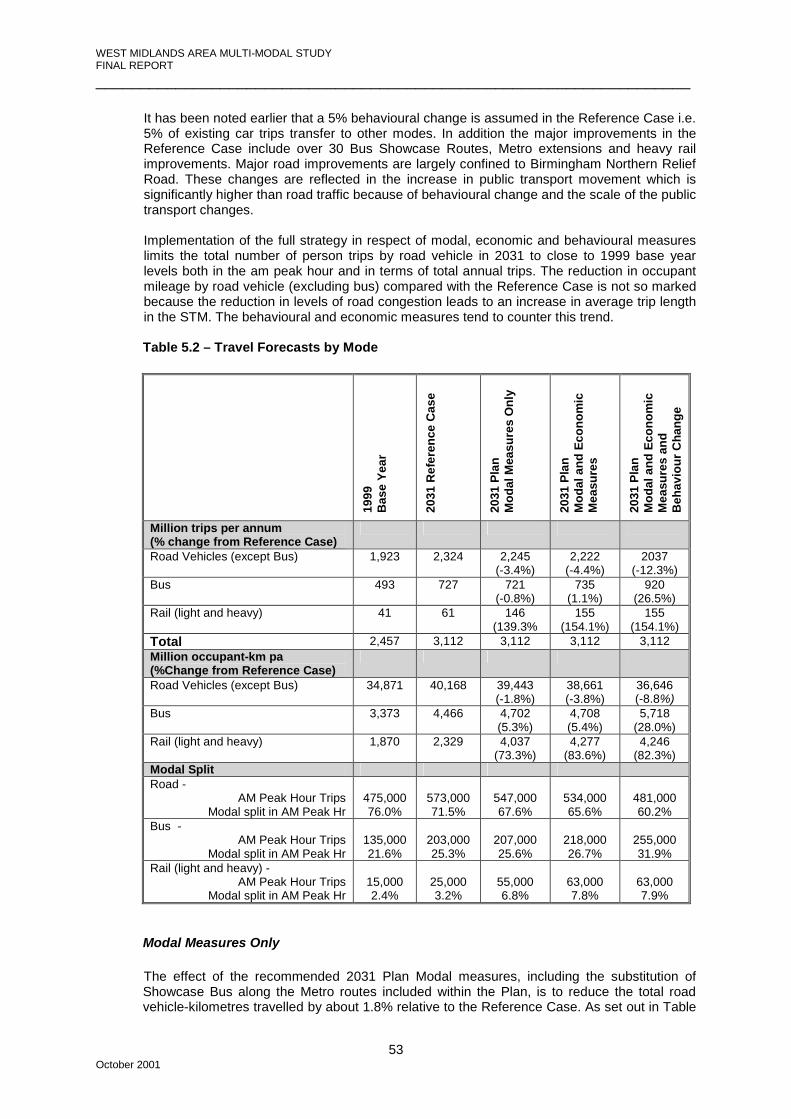
WEST MIDLANDS AREA MULTI-MODAL STUDY FINAL REPORT ___________________________________________________________________
October 2001
53
It has been noted earlier that a 5% behavioural change is assumed in the Reference Case i.e.
5% of existing car trips transfer to other modes. In addition the major improvements in the Reference Case include over 30 Bus Showcase Routes, Metro extensions and heavy rail improvements. Major road improvements are largely confined to Birmingham Northern Relief Road. These changes are reflected in the increase in public transport movement which is significantly higher than road traffic because of behavioural change and the scale of the public transport changes. Implementation of the full strategy in respect of modal, economic and behavioural measures limits the total number of person trips by road vehicle in 2031 to close to 1999 base year levels both in the am peak hour and in terms of total annual trips. The reduction in occupant mileage by road vehicle (excluding bus) compared with the Reference Case is not so marked because the reduction in levels of road congestion leads to an increase in average trip length in the STM. The behavioural and economic measures tend to counter this trend.
Table 5.2 – Travel Forecasts by Mode
1999
B
ase
Year
2031
Ref
eren
ce C
ase
2031
Pla
n M
odal
Mea
sure
s O
nly
2031
Pla
n M
odal
and
Eco
nom
ic
Mea
sure
s
2031
Pla
n M
odal
and
Eco
nom
ic
Mea
sure
s an
d B
ehav
iour
Cha
nge
Million trips per annum (% change from Reference Case)
Road Vehicles (except Bus) 1,923 2,324 2,245 (-3.4%)
2,222 (-4.4%)
2037 (-12.3%)
Bus 493 727 721 (-0.8%)
735 (1.1%)
920 (26.5%)
Rail (light and heavy) 41 61 146 (139.3%
155 (154.1%)
155 (154.1%)
Total 2,457 3,112 3,112 3,112 3,112 Million occupant-km pa (%Change from Reference Case)
Road Vehicles (except Bus) 34,871 40,168 39,443 (-1.8%)
38,661 (-3.8%)
36,646 (-8.8%)
Bus 3,373 4,466 4,702 (5.3%)
4,708 (5.4%)
5,718 (28.0%)
Rail (light and heavy) 1,870 2,329 4,037 (73.3%)
4,277 (83.6%)
4,246 (82.3%)
Modal Split Road -
AM Peak Hour Trips Modal split in AM Peak Hr
475,000 76.0%
573,000 71.5%
547,000 67.6%
534,000 65.6%
481,000 60.2%
Bus - AM Peak Hour Trips
Modal split in AM Peak Hr
135,000 21.6%
203,000 25.3%
207,000 25.6%
218,000 26.7%
255,000 31.9%
Rail (light and heavy) - AM Peak Hour Trips
Modal split in AM Peak Hr
15,000 2.4%
25,000 3.2%
55,000 6.8%
63,000 7.8%
63,000 7.9%
Modal Measures Only The effect of the recommended 2031 Plan Modal measures, including the substitution of Showcase Bus along the Metro routes included within the Plan, is to reduce the total road vehicle-kilometres travelled by about 1.8% relative to the Reference Case. As set out in Table

WEST MIDLANDS AREA MULTI-MODAL STUDY FINAL REPORT ___________________________________________________________________
October 2001
54
5.2, the total number of passenger-kilometres travelled by bus and rail increase by about 5% and 73% respectively relative to the Reference Case. The proportion of total trips by public transport in the am peak period increases from 29% in the Reference Case to 32%.
Modal and Economic Measures
The main effect of the 2031 Plan with Electronic Road Pricing (ERP) would be a 4% reduction in annual road vehicle-kilometres travelled relative to the Reference Case. During the am and pm peak periods the reduction would be greater at around 9%. With the introduction of ERP, in addition to modal measures, bus passenger kilometres would increase by about 5% and rail passenger kilometres by about 84% relative to the Reference Case. Overall the proportion of trips by public transport in the am peak period would increase from 29% in the Reference Case to 35% with the 2031 Plan including a full ERP scheme.
Modal and Economic Measures plus Behavioural Change Applying the targeted behavioural change to the 2031 Modal and Economic measures
produces a further shift of 10% of car trips to other modes. For the purposes of assessment this shift is assigned to the bus mode but in reality a significant number of these trips, particularly the shorter trips, are expected to transfer to the slow modes i.e. walk and cycle.
The main effect of the combination of Modal and Economic measures and Behavioural
Change would be a 9% reduction in annual road vehicle occupant kilometres travelled relative to the Reference Case. The am and pm peak reduction would be greater at around 12 to 13%.
Bearing in mind the comment above relating to slow mode transfer, the modelled proportion of trips by public transport in the am peak increases from 29% in the Reference Case to 40% with the full implementation of the 2031 Plan.
5.6.2 Corridor Movements Figure 5.2 shows the screen lines used to assess changes in person movement in a number of principal corridors across the Study Area. Table 5.3 shows total two-way trips across each screen line in the morning peak in 1999 and 2031, modal share and peak uni-directional road traffic flows.. The screen line around the centre of Birmingham (1-5) shows the lowest proportionate increase in the 2031 Reference Case. This is compatible with what has happened over the last decade where car trips into Birmingham have increased by less than 1% per annum whilst rural traffic has increased significantly more. Several other factors are responsible for the difference between the area-wide total trip increases and modal shares shown in Table 5.2 and the individual screen line measures shown in Table 5.3:-
• trips on the regional motorway links, increase proportionately more than inside the conurbation;
• the 2031 Plan LRT network is centred on Birmingham, Wolverhampton and Walsall
and improved public transport accessibility to these zones increases the total number of trips attracted to each, particularly for non-work, shopping and leisure purposes;
• the RER and LRT services included in the Plan and centred on Birmingham will mean
that more cross conurbation public transport trips will pass through the centre.

WEST MIDLANDS AREA MULTI-MODAL STUDY FINAL REPORT ___________________________________________________________________
October 2001
55
Table 5.3 - Screen Line Vehicle and Person Movements (AM Peak Hour)
Mode Split by %age (total motorised trips)
Screen Lines
Total Trips
(2-way)
One-way peak flow vehs/hr Bus Light
Rail Heavy Rail
Road
Screen Lines 1 - 5 (Central Birmingham) Base Year 1999 127523 42121 24.1 0.9 10.6 64.4 2031 Reference Case 145315 42776 24.0 2.4 15.2 58.4 2031 Modal Measures Only 185495 42121 22.5 7.5 25.0 45.0 2031 Full Plan 185632 33161 26.6 8.6 28.9 35.9 Screen Line 6 (M42 Corridor) Base Year 1999 29798 10776 7.6 0.0 10.4 82.0 2031 Reference Case 39493 12238 16.2 0.0 12.3 71.5 2031 Plan Modal Measures Only 50740 14400 16.3 0.0 19.2 64.5 2031 Full Plan 48522 11838 18.8 0.0 24.7 56.5 Screen Line 7 (E. Birmingham/Solihull) Base Year 1999 43152 14467 14.4 0.0 9.4 76.2 2031 Reference Case 54558 15240 16.5 0.0 12.2 71.3 2031 Plan Modal Measures Only 63050 15064 19.6 0.9 18.8 60.7 2031 Full Plan 59514 12021 22.5 1.0 23.5 53.0 Screen Line 8 (N. Wolverhampton/Walsall) Base Year 1999 43135 16255 16.9 0.0 2.9 80.2 2031 Reference Case 49595 17984 19.4 0.0 3.2 77.4 2031 Plan Modal Measures Only 47620 16662 23.1 0.0 4.4 72.5 2031 Full Plan 44839 14167 28.0 0.0 4.8 67.2 Screen Line 9 (North Black Country) Base Year 1999 39519 12367 17.7 2.4 4.4 75.5 2031 Reference Case 46257 14222 16.7 5.7 4.5 73.1 2031 Plan Modal Measures Only 52547 14653 16.9 4.2 11.9 67.0 2031 Full Plan 49492 11827 21.7 6.2 15.3 56.8 Screen Line 10 (Stourbridge/Black Country)
Base Year 1999 23658 8225 16.1 0.0 2.7 81.2 2031 Reference Case 27558 8872 18.4 0.0 4.5 77.1 2031 Plan Modal Measures Only 28524 8988 20.6 0.0 10.4 69.0 2031 Full Plan 27014 7089 27.0 0.0 13.8 59.2 Screen Line 11 (M5 / A38 Corridor) Base Year 1999 13620 7138 3.2 0.0 4.8 92.0 2031 Reference Case 19200 9935 2.3 0.0 6.5 91.2 2031 Plan Modal Measures Only 18940 8175 1.0 0.0 16.9 82.1 2031 Full Plan 16552 6558 1.2 0.0 20.6 78.2
Figure 5.2 - Screen Line Locations

WEST MIDLANDS AREA MULTI-MODAL STUDY FINAL REPORT ___________________________________________________________________
October 2001
56
5.6.3 Congestion and Journey Times
As links in the highway network approach capacity a small increase in traffic produces a disproportionate increase in delay per vehicle. Conversely a small decrease in flow can produce a large decrease in congestion. The provision of additional highway capacity and better traffic management measures can also help in reducing congestion. Compared with the Reference Case, the 2031 Plan produces an overall decrease of 8.9% in total road vehicle kilometres but that this is made up of a 15% reduction on the non-motorway network and a 2.1% decrease on motorways in the area. The STM incorporates all the above factors and has been used to model the congestion delays in the Study Area compared to free-flow conditions for the base year 1999, and years 2011 and 2031. The results of this analysis are contained in Table 5.4 below. This indicates that the Ten Year Plan targets for congestion are met by the 2011 Plan proposals, with absolute annual congestion delay slightly lower at 78.9 million vehicle-hours than the 1999 base year value of 79.9 million vehicle-hours. The full 2031 Plan shows absolute congestion delay reduced to 72.9 million vehicle-hours, almost 10% below 1999 levels.
Table 5.4 - Congestion Delay 1999, 2011 and 2031
Year Total annual
vehicle-kms (x109)
Total annual
vehicle-hrs (x106)
Total congestion
delay annual
vehicle-hrs (x106)
Average congestion delay per
vehicle-km. (1999
index=100) 1999 Base Year 22.2 411.7 79.9 100 2011 Reference Case 24.3 438.6 80.1 92 2011 Plan 24.2 437.6 78.9 90 2031 Reference Case 28.9 556.5 133.4 128 2031 Modal Measures Only 28.4 523.6 109.1 107 2031 Modal + Economic Measures 27.8 497.7 93.1 93 2031 Full Plan 26.3 453.5 72.9 77
The improvement in highway network conditions is shown diagrammatically in Figures 5.3 and 5.4 in terms of network speeds and flow/capacity ratios respectively for the recommended 2031 Plan Modal Measures and for the full 2031 Plan. These can be compared with the Reference Case situation in 2031 as shown in Figure 3.1 and 3.2. Table 5.5 shows the change in modelled centre to centre peak hour journey times by mode for the 2031 Reference Case and the 2031 Plan compared with 1999. It illustrates the general improvement in both public transport and car journey times with the implementation of the 2031 Plan.
Table 5.5 – Changes in Modelled Average AM Peak Journey Times to Birmingham City
Centre Compared with Base Year 1999 (in minutes) Year and Scenario
Wal
sall
Sutto
n C
oldf
ield
Solih
ull
Red
ditc
h
Bro
msg
rove
Kid
derm
inst
er
Wol
verh
ampt
on
Wes
t Bro
mw
ich
Dud
ley
2031 Reference Case - Car +1 +4 +3 +14 +8 +4 +2 +1 +14 Bus -10 0 -2 +8 +12 +4 -2 -7 -2 Rail 0 0 0 0 0 0 -1 -1 0
2031 Full Plan - Car -8 -3 -9 -5 -2 -6 -12 -5 +6 Bus -9 -8 -10 -13 -11 -9 -9 -13 -9 Rail -7 -2 -13 -14 -18 -6 -1 -2 -7
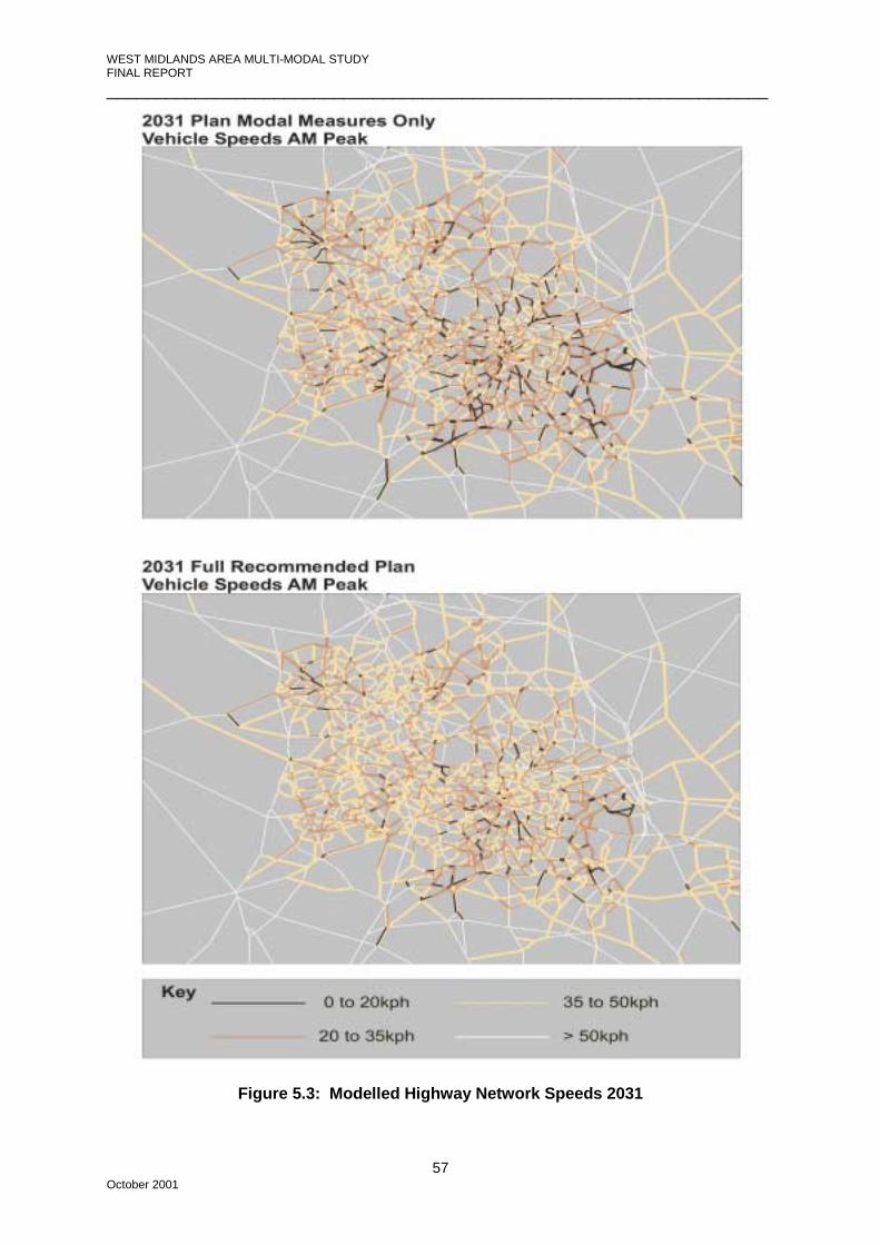
WEST MIDLANDS AREA MULTI-MODAL STUDY FINAL REPORT ___________________________________________________________________
October 2001
57
Figure 5.3: Modelled Highway Network Speeds 2031

WEST MIDLANDS AREA MULTI-MODAL STUDY FINAL REPORT ___________________________________________________________________
October 2001
58
Figure 5.4: Modelled Highway Flow/Capacity Ratios 2031

WEST MIDLANDS AREA MULTI-MODAL STUDY FINAL REPORT ___________________________________________________________________
October 2001
59
5.7 TRANSPORT ECONOMIC EFFICIENCY The transport economic efficiency of the Plan with Modal Measures alone and then together
with Economic and Behavioural measures also applied are summarised below in Table 5.6. The analyses are based on the use of the TUBA software over the period 2001 to 2051 using two modelled years, 2011 and 2031. The 2011 scenario includes all schemes likely to be in place by that date whilst the 2031 scenario includes all of the Plan elements. The benefits and costs indicated are at year 2000 prices discounted to 2000 at a social discount rate of 6%
The investment cost profile is taken from the suggested Plan Implementation Programme shown in Table B.1, Appendix B. The corresponding profile of benefits is conservative because of the lack of an intermediate modelled year, say 2021. Table 5.6 - TUBA Economic Analysis for the 2031 Plan (in £ millions )
IMPACTS
Plan Modal Measure Only
Plan Modal Measures and
Economic Measures
Plan Modal Measures + Economic
Measures + Behavioural
Change
User Benefits Private Travel Time 2,064 2,756 3,717 Bus Travel Time 2,968 3,133 3,526 Rail Travel Time 2,423 2,488 2,511 Vehicle Operating Costs -56 -111 226 User Charges 0 -1,771 -1,645 Net User Benefits (1) 7,399 6,495 8,335 Private Sector Provider Impacts Revenue 925 1,043 1,935 Operating Costs (a) -1,490 -1,490 -1,490 Investment Costs (b) -3,272 -3,272 -3,272 Grant/Subsidy Payments 3,836 3,719 3,383 Net Impact (2) 0 0 557 Public Sector Provider Impacts Revenue (Road User Charging) 0 1,977 1,769 Operating Costs (c) -129 -285 -333 Investment Costs (d) -582 -649 -754 Net Impact (3) -711 1,044 682 Other Government Impacts Grant/Subsidy Payments (e) -3,836 -3,719 -3,383 Indirect Tax Revenue -154 -421 -816 Net Impact (4) -3,991 -4,140 -4,199 Net Present Value NPV
(5)=(1)+(2)+ (3)+(4) 2,698 3,400 5,375
Present Value of Costs, PVC (6)=(a)+(b)+(c)+(d) -5,472 -5,694 -5,848
Present Value of Cost to Government (7)=(3)+(e) -4,547 -2,674 -2,701
Benefit/Cost Ratio, BCR (8)=((5)-(6))/-(6) 1.49 1.60 1.92
Value/Cost to Government Ratio, VCGR (9)=(5)/-(7) 0.59 1.27 1.99

WEST MIDLANDS AREA MULTI-MODAL STUDY FINAL REPORT ___________________________________________________________________
October 2001
60
5.7.1 Modal Measures Only
The Net Present Value of the Plan without Economic or Behavioural measures is calculated at £2.7bn with a Benefit Cost Ratio of 1.49. Total cost to Government, allowing for grants and subsidies, amounts to a discounted sum of £4.5bn. Dividing the Net Present Value by this total gives a Value/Cost to Government Ratio (VCGR) of 0.59. It should be noted that the substantial cost (approximately £2.6bn undiscounted) of four-tracking the Wolverhampton to Coventry WCML together with the proposed cross-city running tunnels and underground platforms at New Street Station is included in the Plan investment costs while the full economic benefits are not. The inclusion of benefits to Intercity services and passengers and Rail Freight passing through the region would improve the economic viability of the Plan. The economic analysis indicates that Grant/Subsidy payments totalling £3.8bn (discounted) would be necessary to underpin the 2031 Plan Modal measures only. Over 80% of this would be in relation to Heavy Rail and Light Rail schemes. Further detailed work is needed to establish the commercial viability of individual schemes before the availability of grant funding or subsidy can be confirmed.
5.7.2 Modal and Economic Measures The introduction of Road User Charging has several economic effects. The reduction in car
trips produces user timesaving for all modes on the road network (car, bus and light rail) because congestion is reduced. The shift to public transport produces additional fare revenue and road user charging, although a disbenefit to private vehicle users, produces substantial revenue for local transport schemes. This in turn produces a large reduction in the overall cost to Government from £4.5bn to £2.7bn discounted. The BCR is improved to 1.60 and the VCGR is increased from 0.59 to 1.27.
5.7.3 Modal and Economic Measures and Behavioural Change
The final column in Table 5.6 sets out the results of the economic analysis assuming that the targeted behavioural change is achieved. Large benefits accrue from the reduction in congestion, increasing the NPV of the full Plan to £5.4bn. The Benefit Cost Ratio increases to 1.92 but the cost to Government remains at around £2.7bn discounted, with a VCGR of 1.99. Again it is noted that the cost of ‘national’ rail schemes are included at an undiscounted cost of approximately £2.6bn without the identification of full economic benefits to ‘through region’ rail traffic. The Grant/Subsidy necessary reduces to £3.4bn, all in respect of light and heavy rail schemes. Because of the factors discussed in the Study’s Phase 4 and 6 Report and summarised in Section 7.2.2 of this Report, the net revenue from Electronic Road Pricing for investment in local transport schemes could be reduced by up to a half. The effect of this on the economic analysis for the 2031 Plan would be a slight reduction in the Benefit Cost Ratio to 1.91. However, the Present Value of Cost to Government would increase from £2.7bn to £3.6bn because of the reduced revenue from road user charges and, as a result, the Value/Cost Ratio to Government would fall from 1.99 to 1.48.
5.8 ALTERNATIVE SCENARIOS
The Plan Development and Appraisal phase examined a wide range of plan options both at local and area-wide level and the results of the process are fully documented in the Phases 4 and 6 Report for the Study. It is interesting to note that the European Commission have chosen 14 cities for pilot programmes under the EU’s Civitas initiative to tackle transport pollution and congestion. These pilot schemes, such as the Bristol Civitas scheme, are to examine the effectiveness of combining a range of measures such as Green Travel plans, public transport improvements, better marketing and travel awareness campaigns and the introduction of road pricing access

WEST MIDLANDS AREA MULTI-MODAL STUDY FINAL REPORT ___________________________________________________________________
October 2001
61
management systems. The aim is to gauge the usefulness of individual measures and the best way of combining them on a large scale. Similarly the essence of the WMAMMS strategy is that the proposed interventions in the three chosen ‘drivers’: behavioural change, economic intervention and modal measures, must be viewed as complementary. The forecast outcomes of combining these effects on the scale proposed obviously has some attendant assumptions and it is informative to consider a number of ‘what if’s’ in relation to the delivery of the recommended Strategy and Plan. The following ‘what if’ scenarios are discussed in the following sections:- • Behavioural Change fails to deliver the targeted shift away from car use. • Road user congestion charging is not implemented. • Some significant modal measures, which are either particularly contentious or problematic
in terms of delivery, are not implemented. 5.8.1 Non-delivery of Behavioural Change
The emphasis placed on the need for a change in travel behaviour and attitudes by the 1998 Integrated Transport White Paper (ITWP) has been fully reflected in the development of a long term strategy to address the existing and future transport problems in the Study Area. The means to achieving the significant 10% behavioural change envisaged in the recommended strategy is outlined in this report but, although this scale of change is considered by the Study team to be a realistic target, the implications of a scenario where this target is not achieved should be considered. The most obvious result of the failure to implement behavioural change to the targeted levels would be an increase in congestion levels across the Study Area, affecting the centres more than the outer areas. Figures 5.3 and 5.4 show the variations in network speeds and congestion with the implementation of modal measures only, compared with the full 2031 Plan with the targeted behavioural change and congestion charging. Reasons for the partial or total failure of the behaviour change intervention might include: • Failure to commit adequate finance and human resources to encourage change; • Failure to deliver comprehensive, good quality walking, cycling and public transport
facilities; • Failure to introduce road user charging; • Increased car trip making taking advantage of reduced congestion; • Resistance of car drivers to changing their travel behaviour.
Behavioural change would deliver area-wide benefits. Assuming that the remainder of the strategy is implemented then compensation for the failure of behavioural change intervention is unlikely to be produced by additional levels of modal interventions because of this area-wide effect. Further wholesale capacity increases over the whole highway network are considered to be undeliverable. The same level of behavioural change could however in theory be achieved by higher levels of road user charging. Electronic road pricing tolls equivalent to £3.00 for an average car trip in the peak hour have been used as the basis of the Study’s recommendations in respect of economic intervention. The behavioural effect of tolling is difficult to predict for the reasons discussed in Chapter 7 and the level of tolls tested may in fact produce a higher behavioural change than the modelling would suggest.
5.8.2 Non delivery of Road User Charging
If road user charging cannot be delivered, it is likely to fail for political rather than technical reasons since the technology is currently available and in use outside the UK. The strategy and plan have been developed on the basis that each driver of change; land use, behaviour, modal investment and economic instruments will all contribute to the level of travel by each mode. In particular, the recommendations are designed to achieve a

WEST MIDLANDS AREA MULTI-MODAL STUDY FINAL REPORT ___________________________________________________________________
October 2001
62
significant change to more sustainable modes, such that the amount of congestion on the highway network is lower than currently experienced. Failure to achieve the targeted mode change by congestion charging will require a higher intervention level on the other three drivers. In practice this is likely to mean that more behavioural change and/or higher levels of investment in new infrastructure over the Study Area will be required. The Steering Group was reluctant to accede to higher levels of behavioural change (+10% over the Reference Case by 2031), on the grounds that whilst it might be possible to achieve these in small areas or specific sites, it was unrealistic to expect a higher level of change over the whole conurbation. Higher levels of investment in modal schemes on an area-wide basis might be possible. However, if this took the form of additional public transport improvements coupled with further significant reallocation of road-space to bus-lanes and street-running LRT, based on consultations with Centro and the local authorities during the Study, deliverability would be questionable. On a wider basis, competing resource demands for health, education and social services led the Study Team to believe that its recommendations for modal schemes were realistically cost-effective and at a level which could be afforded on the basis of the recently published Ten Year Plan for Transport.
5.8.3 Non-delivery of Modal Infrastructure Components – Heavy Rail Improvements
Recent experience of delivery and safety problems in the rail industry suggests that the effect on the 2031 Plan of non-delivery of major heavy rail improvements should be assessed. A key part of the 2031 Plan is a radical improvement of regional rail services through the introduction of a Regional Express Rail (RER) network of services but existing capacity restraints in and around New Street would severely limit the scope for such a system. To allow the introduction of the RER, the critical heavy rail components of the 2031 Plan are the construction of a new underground level at New Street Station with cross-city service tunnels and the four-tracking of the Coventry to Birmingham to Wolverhampton main line. These plan components can only be partially justified by economic benefits accruing to regional and local rail services and passengers. Undoubtedly these major infrastructure improvements would provide significant benefit to inter-city and cross-country rail services. However, the quantification of such benefits is beyond the scope of WMAMMS. If these Plan components are not delivered then the concept of an RER system linked with Strategic Park and Ride sites would be impracticable and the incremental impact of the RER system as assessed in the Study’s Phases 4 and 6 Report would not accrue. As reported, the combined effect of the RER plus Strategic Park and Ride would be to increase rail modal share across the Study Area by around 50%, from 4.1% to 6.1% of total trips in the AM peak hour. Annual passenger kilometres travelled by rail would increase from 2.71billion, without the RER, to 3.65billion while annual road vehicle kilometres would decrease by 634 million. In terms of increasing rail patronage, the effect of the 2031 Plan is to increase forecast annual rail patronage by 82% from 2.33 billion pass-kms in the 2031 Reference Case to 4.25 billion pass-kms. Non-delivery of the RER would reduce this to 3.31 billion i.e. a 42% increase over the Reference Case.
5.8.4 Non-delivery of Modal Infrastructure Components – Western Bypasses Background Because of the history of the previously proposed Birmingham Western Orbital Route, any new proposal for highway schemes to the west of the conurbation will be contentious. Although the recommended Plan options for the western bypasses of Wolverhampton and Stourbridge are very different in terms of location, scale and purpose, it is possible that these components of the Plan may be difficult to implement and this possibility is discussed below.

WEST MIDLANDS AREA MULTI-MODAL STUDY FINAL REPORT ___________________________________________________________________
October 2001
63
Implicit in the 2031 Plan is the assumption that the existing M5/M6 corridor through the west side of the conurbation should retain its strategic role for through traffic. The consequence of this is that the function of the western bypasses of Wolverhampton and Stourbridge should principally be to improve accessibility to the west of the conurbation, particularly the Black Country regeneration areas and that the standard, junction provision and location of these routes should be appropriate to this role rather than providing for longer distance through traffic. The adoption of this Plan component as part of the 2031 Plan is based on the Strategic Highways Scenario Two package test described in the Phases 4 and 6 Report (Chapter 3). This included western bypasses of both Wolverhampton and Stourbridge constructed to dual carriageway all-purpose highway, generally to two lane standards with three lanes on junction approaches. The routes would be aligned closer to the conurbation than previous western route proposals and would have at-grade junctions with principal radial routes. The bypasses would not be intended to form a strategic route for long distance traffic passing through the region and travelling between the south/south-west and north-west and would not be signed as such. They would be expected to carry mainly traffic with an origin or destination, or both, in the west side of the conurbation. These options would help meet the Study objective of improving access to the western conurbation and assisting regeneration by:
• providing direct access between the motorway network and the areas to the west of Wolverhampton and Dudley. This would allow improved access to and from other parts of the West Midlands and beyond;
• relieving the M5 and M6 motorways of some traffic with origins or destinations in the
west of the conurbation which would improve access (via the M5 and M6) for the remainder of the Black Country and other areas to the east of the M5; and
• would be complemented by strengthening of the internal road network in the Black
Country, which would also be relieved of traffic, providing significant regeneration opportunities.
Effect of Non-delivery An important objective of the Study, the improvement of access to the western conurbation to assist with regeneration, would be severely compromised by non-delivery of the western bypasses. This would also result in the loss of transport user benefits of approximately £1,468 million discounted to 2000. These benefits accrue with the western bypass options mainly due to the effect of removing traffic from the congested Black Country highway network together with some relief of the M5/M6. Alternatives to the western bypasses which could be considered include the widening of the M5/M6 through the Black Country and/or the development of a north-south strategic highway corridor within the urban fabric of the western conurbation, possibly following the A491. These alternatives are also likely to be difficult to implement and were discounted in favour of the recommended western bypass routes for the following principal reasons:
• Widening of the M5/M6 would pose significant constructional difficulties, particularly on the elevated sections, with the need to keep motorway traffic moving. It would have a significant impact on the urban environment and although improving access to the eastern part of the Black Country, access to the west would not be improved.
• A north-south strategic route within the Black Country, possibly along the A491
corridor would also have a major impact on the urban environment, through property demolition and severance, to accommodate the scale of improvement required.

WEST MIDLANDS AREA MULTI-MODAL STUDY FINAL REPORT ___________________________________________________________________
October 2001
64
5.8.5 Possible Substitution of Motorway Improvements for other Measures
The failure of both behavioural and economic interventions for the reasons postulated above together with a failure to implement the recommended heavy rail improvements, including the RER, is considered to be an extreme downside and highly unlikely to occur. However, a view might be taken that the provision of additional motorway capacity could substitute for the failure to implement other measures and this hypothesis is considered here. Alternative major highway plan options were tested and reported in Chapter 3 of the Phases 4 and 6 Plan Development and Option Appraisal Report. The scenario carried forward to the recommended 2031 Plan, envisaged the existing motorway network with some capacity improvements, together with BNRR, remaining the strategic motorway network with non-motorway local bypasses to the western side of the conurbation. The main alternative area-wide scenario examined the possibility of significant increases in the capacity of the regional motorway network with a motorway ‘box’ around the conurbation formed by the BNRR, the M42, a motorway route to the west of the conurbation from the M5 south to the M54 together with a link from the M54 to BNRR. This scenario excluded the implementation of the RER system and Strategic Park and Ride as well as the effect of economic and behavioural interventions, apart from the 5% behavioural change assumed in the Reference Case. However, other modal measures, including Super Showcase bus were included.
This scenario included the following measures:
• M42 between the M5 and Junction 3A(M40) - widening from dual 3 lanes to dual 4 lanes;
• M42 between Junction 3A (M40) and Junction 9 (BNRR) – an additional new 3-lane motorway parallel to the M42.
• Birmingham Northern Relief Road; • A motorway standard link from the Birmingham Northern Relief Road to M54; • An outer Western Route (M5/M42 Junction to M54 and M6/BNRR) built to motorway
standards. In addition, widening of the M6 between Junction 8 (M5) and Junction 10A (M54) from dual 3 to dual 4 lanes was included in the test and all motorway links, whether widened or not, have been modelled assuming area-wide traffic management measures, (Active Traffic Management) that would increase capacities by a minimum of 10%. Table 5.7 compares congestion and modal split for various scenarios.
Table 5.7 - Congestion Delay and Modal Split
AM Peak Hour Modal Split
Year Total annual vehicle-
hrs (x106)
Total congestion
delay annual
vehicle-hrs (x106)
Index of average
congestion delay per
vehicle-km. Road Bus Rail
1999 Base Year 411.8 79.9 100 76.0 21.6 2.4 2031 Reference Case 556.5 133.4 128 71.5 25.3 3.2 Modal Measures Only 523.6 109.1 107 67.6 25.6 6.8 Full Plan 453.5 72.9 77 60.2 31.9 7.9 Alternative Highway Scenario 522.4 107.9 106 67.8 28.0 4.2
The provision of any additional capacity on the motorway network in the Study Area tends to attract traffic from, and therefore relieves congestion on, some of the surrounding non-motorway network. However, this would increase congestion on motorway approach roads. A
WEST MIDLANDS AREA MULTI-MODAL STUDY FINAL REPORT ___________________________________________________________________
October 2001
65
further effect of a motorway standard western route is to switch some north-west to south-east through traffic to this route from the M6 and BNRR. Overall the relief of congestion and the percentage of AM peak hour car trips is similar to that achieved with 2031 Plan modal measures only.
Though viable in terms of transport economic efficiency, a motorway-standard western route is inferior to the recommended western bypasses on both environmental and economic grounds and with respect to other Study Objectives. If a new route to the west of the conurbation were excluded then, area-wide, operationally similar results could be obtained by the further widening of the remainder of the M42, M5 and M6 motorway box to four lanes. Though this scenario could, in terms of overall congestion delay and percentage car trips, replicate the effect of the 2031 Plan modal measures, wholesale widening of the existing motorway box would:-
• be extremely difficult and costly from a construction point of view; • involve major environmental impacts on urban areas during construction; • seriously disrupt the flow of motorway traffic through the region for several years
while widening was carried out; • increase pressure and congestion on radial routes and their junctions with the
motorway unless motorway access was restricted or tolled; • fail to bring significant congestion relief to central areas; and would • fail to significantly improve access to the western side of the conurbation.
It is considered that the alternative of major increases in capacity for the motorway network in the Study Area would be unable to compensate for the failure of the behavioural or economic intervention levels envisaged in the recommended 2031 Plan. Neither is this scenario a direct substitute for major components of the 2031 Plan, such as heavy rail improvements/RER or the western bypasses.
WEST MIDLANDS AREA MULTI-MODAL STUDY FINAL REPORT ___________________________________________________________________
October 2001
66
6.0 RECOMMENDED MODAL SCHEMES AND MEASURES The 2031 Strategy and outline Plan have been described in Chapters 4 and 5. The
recommended modal schemes, economic measures and travel behaviour initiatives are described in detail in the following Chapters of the Report.
Mode choice is affected by a number of factors, including journey time, reliability, affordability and availability. Changes in modal choice can be effected by major investment in infrastructure and an essential component of the long term strategy is a significant increase or ‘step change’ in the provision across the modes. The public transport network would consist of high quality, high frequency bus services and an integrated rail network of Midland Metro, Regional Express Rail (RER) suburban rail routes and intercity/cross country services. There would also be a significant increase in the strategic highway capacity together with further improvements in interchange facilities between modes including additional rail freight interchange facilities. The scale of provision of the various modal schemes and measures recommended below is dependent on the complementary behavioural and economic aspects of the strategy being achieved at the recommended intervention levels.
6.1 WALKING AND CYCLING Walking and cycling are the most sustainable forms of travel and walking is a constituent part
of every journey that is made. The attention given to the ‘soft modes’ in a long-term plan should reflect their importance to the transport system as well as the potential health benefits for individual travellers.
Expenditure on these modes, particularly cycling, has been well below the average Western
European level and the UK has considerable catching up to do. In the context of the approach we have taken to the Study, there is a strong linkage between the Behavioural Change strand of the Strategy and improved walking and cycling facilities. For this reason the soft mode recommendations below should be implemented as early as possible in the Plan period to encourage modal shift, particularly of shorter trips.
Existing walking and cycling strategies within the Conurbation and the neighbouring counties are well defined within the Local Transport Plans. The 2031 Plan is based on these strategies but with the following modifications: Safety and comfort:
• developing a more conducive environment for both walking and cycling;
• a continued and increasing emphasis on safety through segregation e.g. whenever
possible segregated cycle lanes should be introduced on major strategic corridors. • a further allocation of road space within the highway boundary to enhance walking
and cycling safety and convenience; • improved walking and cycling facilities both in towns and residential areas, including
the use of traffic calming and enhanced pedestrian crossing facilities;
• improved street lighting, signing and road, cycleway and footpath maintenance;
• continuing consideration of the needs of the disabled.

WEST MIDLANDS AREA MULTI-MODAL STUDY FINAL REPORT ___________________________________________________________________
October 2001
67
Integration:
• walking and cycling routes which are further integrated to more directly link local centres, work places, schools, shops, public transport interchanges, health centres and hospitals;
• a continued support for leisure usage, but with greater priority given to more essential
journeys’ such as to work, to school etc.;
• the incorporation of national strategies within local strategies and programmes e.g. National Cycling Strategy;
• walking and cycling are now integrated within local authority plans and programmes.
Such integration should include the further development of Green Travel Plans, Safer Routes to School, UDP policies and other cycling and walking initiatives;
Ownership:
• more local authorities and major employers setting good examples for promoting walking and cycling through Green Travel Plans;
• better community participation to induce a sense of ‘ownership’ in walking and cycling
schemes; (ownership);
• further partnership initiatives with organisations such as the health and education authorities, SUSTRANS etc;
Targets: The Behavioural Change target recommended by the Study envisages a 10% reduction in car trips by 2031 in addition to the 5% change incorporated in the Reference Case. For shorter trips, up to about 5km, the majority of this transfer would be from car to walk and cycle mode. Longer trips have been assumed to transfer to public transport. The West Midlands Local Transport Plan (WMLTP) set the following targets for walking and cycling:
• 5% and 8% of all journeys in the West Midlands to be by cycle by the end of 2006
and 2012 respectively; • individual local authority walking strategies to be in place by April 2001;
• 80% of pedestrian crossings in each district with facilities for the disabled.
Targets for journeys by walking are difficult to identify given the problems in quantifying and monitoring and such journeys. A more realistic target for the eventual (2031) proportion of cycling trips is 10%, with 80% of households within ½ mile of a dedicated cycle network and our recommendations are designed to achieve this level of provision. Investment: On the basis of current evidence both the Study and WMLTP targets are unlikely to be achieved without further significant intervention as described above and substantially increased resources and investment for the development of the soft modes. Current expected expenditure on walking and cycling initiatives in the conurbation is just over £4million per year. Our recommendation is that the level of expenditure should be increased
WEST MIDLANDS AREA MULTI-MODAL STUDY FINAL REPORT ___________________________________________________________________
October 2001
68
to at least £10million per year. This would be in addition to spending on road improvements, which should automatically incorporate enhanced walking and cycling provision.
6.2 PUBLIC TRANSPORT The Plan Development and Option Appraisal process has identified an integrated public
transport network, with a variety of modes including heavy rail, light rail and bus services. The public transport modes, have been structured into a hierarchy; which closely parallels the corresponding functional road hierarchy, viz.:
• Heavy rail, • Light rail, • Super Showcase Bus, and • Bus Showcase.
It is envisaged that the various elements of the network will be delivered in stages over the
next thirty years. The on-street components, Bus Showcase, Super Showcase and Light Rail are considered as three stages in an evolutionary process. Bus Showcase routes would “evolve” to Super Showcase then light rail, if appropriate, depending on passenger demand and deliverability.
While Bus Showcase proposals tend to utilise existing highway land it is likely that both Super
Showcase and light rail will also require non-highway land and will consequently be more difficult to deliver.
6.2.1 Showcase and Super Showcase Bus
A network of Super Showcase Bus routes, representing a significant improvement in provision approaching rapid transit bus standards, is recommended. This will involve a corresponding reallocation of road space, where practicable, together with bus priority measures at junctions. With inclusion of measures to provide priority over private vehicles, the measures positively influence modal shift away from the car, thereby reducing emissions and producing high economic transport user benefits overall. Significant priority for buses by means of selective vehicle (bus) detection at signal-controlled junctions, bus gates on single carriageway roads and shorter lengths of peak period bus lanes on the approaches to major junctions. These measures seek to introduce higher levels of bus priority, compared to those currently provided on the existing Bus Showcase routes, to improve average peak hour speeds for buses on Super Showcase routes to approach that of cars.
In addition to bus priority, on-street improvements for passengers will include easy boarding
facilities, improved shelters and real time information. The bus companies will renew their fleets with a variety of low floor vehicles, including both single and double deck buses and articulated buses.
Segregating buses from other road vehicles will allow better reliability and improved bus
journey times, but Super Showcase will have greater impacts on the built environment, compared with the current Bus Showcase improvements. Super Showcase will be similar to light rail, in that the vehicles will as far as possible, be segregated from other road users. This may require grade separation at major junctions and land acquisition. The environmental and social impacts will be greater than Bus Showcase, but the quality of service will be similar to light rail at a much reduced capital cost.
Extensive bus priority will involve both spatial segregation and time segregation. Spatial
segregation requires dedicated rights of way for buses, such as bus lanes and bus-only roads. This will prove difficult on some routes as acquiring non-highway land, constructing grade separated junctions or re-allocating road space may affect deliverability. In these instances in the short term it will be necessary to provide time segregation, allowing bus services dedicated “slots” of time at traffic signal junctions.

WEST MIDLANDS AREA MULTI-MODAL STUDY FINAL REPORT ___________________________________________________________________
October 2001
69
The Super Showcase routes will have significant traffic signal control, at all major junctions, to provide priority for buses and slow down other road users. An upgraded area-wide Urban Traffic Control (UTC) centre will allow Selective Vehicle Detection (SVD) and give bus services priority, as and when necessary. This will balance the needs of public and private transport, increasing bus speeds and improving reliability. The UTC system will also provide an interface with real time information, providing public transport information to passengers through a variety of mediums, including the World Wide Web, telephone/text and on street displays.
It is considered that the majority of the strategic urban bus network at 2031 will comprise
Super Showcase routes totalling approximately 380km. These routes will provide bus speeds which are close to car speeds in the peak periods. Cross-border Showcase routes, totalling about 170km, will be to existing Showcase standards extending out of the core of the conurbation to the peripheral towns, in the Journey to Work Area, including:
• Tamworth; • Knowle; • Redditch; • Aldridge / Brownhills; • Cannock; • Bromsgrove; and • Kidderminster.
The development of light rail from specific Super Showcase routes is dependent on satisfying the economic, operational and deliverability criteria. The choice of mode will be determined following further, more detailed, technical assessments, public consultation, political consideration, the Transport and Works Act process and funding procedures.
While the capital costs for ‘traditional’ Showcase routes is typically £0.2 to £0.3m per km, on
average, it is estimated that Super Showcase would cost £1.2m to £1.5m per km, depending on location and the scale of works needed. These additional Super Showcase bus costs and separate costs for particular carriageway widening works are included against the 2031 Plan. Average costs for Light Rail currently can be up to 8 to 10 times this amount for an equivalent route length.
6.2.2 Highway Corridor Improvements for Super Showcase Bus and LRT Metro
Upgrading of specific highway corridors will be required for bus or light rail proposals. Junction capacities should be increased to be compatible with link capacity and to provide priority for both bus and light rail services wherever reasonably practicable. These improvements will be supplemented by the ‘Red Route’ traffic management proposals included in the 2031 Plan and described later in this report. The WMAMMS Study Phases 4 and 6 Report outlines the broad scope of improvements that will be necessary for the various routes. These are recommended for detailed investigation to determine cost-effective improvements to meet the strategy objectives for bus transit speed improvements as well as an overall increase in non-motorway strategic highway capacity.
Historically, one of the problems of introducing a Bus Showcase route has been the time
taken to obtain the necessary agreement of all parties and design and introduce the facilities. This will always be the case and in order to avoid undue delay, it is recommended that a Super Showcase route should be introduced if 50% of the requirements can be met. The remaining 50% can be completed as the plan proceeds towards full implementation.
At the earliest stage possible, i.e. following feasibility studies, land acquisition and advanced
landscaping such as tree planning should be undertaken, or when redevelopment opportunities are presented.

WEST MIDLANDS AREA MULTI-MODAL STUDY FINAL REPORT ___________________________________________________________________
October 2001
70
6.2.3 Light Rail ‘Metro’ Network
The Plan Development and Appraisal phase has identified a major expansion of the LRT from the existing Line 1 and the two extensions included in the Reference Case. The economic and operational performance of possible component light rail routes and services have been considered and a number of these routes demonstrate economic viability. There are, however, several major issues that will have to be addressed in order to ensure the delivery of the light rail network.
The major issues that may delay or prevent the development of a light rail network are:
• existing highway corridors will be affected, including carriageways, landscaped areas,
central reservations and mature trees;
• land acquisition including buildings and frontages is certain to generate local opposition; and
• uncertainty during the planning stages will create blight.
To minimise the potential impact of these issues, Centro and the local authorities should
commission the relevant studies immediately, to answer as many of the concerns as possible. A detailed assessment of both Super Showcase and LRT routes will address these issues and help to allay uncertainty.
The 2031 Plan light rail network consists of ten routes, mainly centred on Birmingham,
Wolverhampton and Walsall (these are in addition to Midland Metro Line One and the currently planned extensions to Five Ways and Merry Hill/Brierly Hill). The major issues listed above affect all of these routes, to a greater or lesser extent:
• Birmingham to Walsall • Birmingham to BIA via Chelmsley Wood • Birmingham to BIA via Sheldon • Birmingham to Shirley – Solihull • Birmingham to Moseley – Kings Heath – Maypole • Birmingham to Northfield • Birmingham to Quinton – Halesowen • Walsall to Wednesbury • Walsall to Wolverhampton • Wolverhampton to Dudley
The two routes in East Birmingham to BIA, via Chelmsley Wood and Sheldon, would be
connected into a loop to form a continuous route. Passenger loadings on the Birmingham to Quinton-Halesowen route would increase, on the
Hagley Road/Broad Street section, if additional light rail services were provided to Londonderry and Bartley Green. The incremental viability of these latter two services will require further investigation but it is recommended that these should be introduced as Super Showcase routes in the first instance to establish demand for an enhanced service. With the exception of the Walsall-Wednesbury (part) and the Wolverhampton-Dudley routes, the recommended LRT routes will run predominantly ‘on street’. They will generally replace Super Showcase routes which will be implemented earlier in the programme, in conjunction with the relevant corridor improvements.

WEST MIDLANDS AREA MULTI-MODAL STUDY FINAL REPORT ___________________________________________________________________
October 2001
71
6.2.4 Heavy Rail Regional Express Rail (RER)
The major heavy rail innovation in the 2031 Plan is the introduction of a Regional Express Rail network. The extent of proposed network has been developed with the benefit of close consultations with all the major rail industry partners, including the SRA, Railtrack and Centro. The assessments show that there are economic and operational benefits offered by developing such an integrated modern rail system that would connect towns and cities within and around the edge of the conurbation with central Birmingham. The system would include services that continue through the centre providing cross-conurbation links between the following centres:-
• Coventry – Birmingham – Wolverhampton • Cannock – Walsall – Birmingham – Nuneaton • Lichfield – Birmingham – Redditch • Tamworth – Birmingham – Worcester • Leamington/Warwick – Birmingham – Kidderminster • Walsall - Birmingham – Shirley – Stratford Depending on viable passenger demand, services could also be extended to other centres such as Telford, Shrewsbury, Stafford and Rugby. In principle the RER would be similar in concept to the German S-bahn system and would generally run on tracks adjacent to the main heavy rail routes including Intercity Services. Existing local rail services that run on the RER routes would be withdrawn and replaced by the RER services which generally operate at a higher frequency of 6 trains per hour. Where four track rail systems exist or are planned, two tracks would be occupied by the RER and two tracks retained for heavy rail services. It is envisaged that that such a network could be delivered in two phases:
Phase 1, centred on a Moor Street/Snow Hill network and Phase 2, centred on a New Street network. The Moor Street/Snow Hill network would require infrastructure between Moor Street and Dorridge, Stourbridge and Kidderminster, Walsall and Bescot and a new connection from the Walsall line into Snow Hill. It is assumed that the new tracks will be built on either side of the existing formation. In addition to the new track works and signalling, platforms would have to be lengthened at all stations. The estimated capital cost for all these works is £210m. Railtrack consider that these measures could be delivered within the next ten years, taking account of the necessary Transport and Works Act procedures. This level of infrastructure would allow for six trains per hour within the core of the conurbation (Walsall, Stourbridge, Shirley and Dorridge), further four-tracking would be required, elsewhere on the network, to allow for this level of service to destinations such as Kidderminster. This capacity would be provided in Phase 2.
Phase 2 is dependent on major station and tunnelling works at Birmingham New Street station and four-tracking of the Coventry-Wolverhampton line. This additional capacity at the hub of the national rail network will allow for a significant increase in the number of intercity services, direct services from New Street to Birmingham International Airport as well as a much more extensive RER network
It will also be necessary to widen the existing railway formations between: • Walsall and Bescot; • Nechells and Water Orton; • Kings Norton and Barnt Green; and • to provide new tracks on the disused formation between Moor Street and Dorridge.

WEST MIDLANDS AREA MULTI-MODAL STUDY FINAL REPORT ___________________________________________________________________
October 2001
72
Even though these aspirations require much more detailed consideration, and subject to
funding, it would be possible to complete the necessary procedures and deliver these major infrastructure projects within the next twenty years.
Other Heavy Rail Schemes
The implementation of the RER network is dependent on a number of major infrastructure improvements and upgrades, the most important being the underground station at New Street and the widening of the Wolverhampton – Coventry route to four tracks, which allows a significant increase in the capacity at the hub of the national rail network. The current estimate for completing the four tracking between Coventry and Wolverhampton, including an underground station at New Street, with tunnel connections onto the Lichfield-Redditch line, is between £2 billion and £2.5 billion. (Part of this work, the four tracking of Coventry to Birmingham line between Beechwood Tunnel and Stechford, is included in the Reference Case). The proposed underground station will allow for direct walking routes to/from New Street and Moor Street platforms, effectively creating one central station in Birmingham city centre.
The West Coast Line four tracking and service improvements between Wolverhampton and
Birmingham and the New Street Station improvement and tunnel connections are expected to show significant user benefits and reliability improvements for long distance travel movements. It has not been possible to quantify these benefits in this Study but the substantial investment costs involved in this work should not be incrementally justified by benefits to regional rail users alone. The importance of improving the hub of the national rail network in terms of benefits to existing and future inter-city rail users needs to be taken into consideration.
The construction of the tunnel and underground station is a major civil engineering project
which will potentially disrupt Birmingham City centre for several years. During the planning stages the uncertainty of the route alignment will also create uncertainty for city centre land uses. To minimise these uncertainties the Strategic Rail Authority should commission the relevant studies immediately.
The increase in capacity will allow much more flexibility in the operation of the local rail network. There will also be opportunities for direct rail services from a variety of origin stations, such as Stourbridge and Lichfield to BIA.
An additional rail scheme, the ‘Birmingham International Connection’ which provides a direct
link between Tamworth (and the East Midlands) and Birmingham International Rail Station is recommended for cross-country connections to BIA. This route would utilise a disused rail formation to allow services from the north and east to connect into the West Coast Main Line. Though it would be difficult to justify investment in this route based on existing demand, it is considered that potential future demand on this route will be significant, as growth at BIA continues and a more sustainable modal share for public transport is required.
Rail Freight Lines The 2031 Plan recommends a new rail-freight route on the re-opened Stourbridge – Walsall –
Lichfield line and electrification of the Walsall – Rugeley and Walsall – Nuneaton (via Sutton Park) lines. Re-opening the Stourbridge-Walsall-Lichfield line will provide a major new freight route between the south west and north east, avoiding the need to pass through the central Birmingham area. Electrification and upgrading of the Sutton Park route would provide an alternative freight route from the south east towards the north west, again avoiding the need to pass through central Birmingham. These proposals allow for new routings of freight through the area, diverting around the congestion in the central area, and improving the reliability of both rail freight and passenger services.

WEST MIDLANDS AREA MULTI-MODAL STUDY FINAL REPORT ___________________________________________________________________
October 2001
73
6.2.5 Strategic Park and Ride
The 2031 Plan includes an additional series of major Park and Ride sites, generally located around the edge of the conurbation. As with other transport options, park and ride has been considered within a hierarchical scale of provision. This does not imply that one type of park and ride user is more important than another, but it does signify the status of the interchange. The hierarchy elements comprises: • Parkway Stations; • Strategic Park and Ride; and • Local Park and Ride The Parkway stations will allow for interchange between the local, Regional Express Rail services and the long distance national rail services, providing for longer distance park and ride users. These stations will provide an important function, allowing passengers access to the national network without the need for travelling into Birmingham city centre. ‘Parkway’ Stations’ in the Study Area are: • Brinsford (north of Wolverhampton); • Warwick; • Longbridge; • Kingsbury; • Kidderminster; and • Birmingham International. Warwick Parkway and Birmingham International are existing facilities, which could be expanded, while the proposal at Brinsford is included as part of the Study Reference Case. The recommended Strategic Park and Ride sites listed in Table 6.1 will allow access into the major centres in the Study Area. These sites have been assessed on the basis of their general location and the ability to access the public transport network, particularly the RER. In addition expanded park and ride facilities at existing stations will provide opportunities for interchange across the whole public transport network. It is expected that these local facilities will be delivered through the LTP process, as considered in the Reference Case. All Park and Ride sites would include facilities for secure storage of bicycles. Table 6.1 - AM Peak Passenger Numbers at Park and Ride Sites
General Location of Strategic Park and Ride
Site
Mode AM Peak Hour Maximum Passenger Demand
Forecasts
M42/M40 Bus to BIA/NEC Up to 750 Brinsford Rail/RER Up to 650 Alvechurch RER Up to 600 Longbridge/Great Park Rail/RER Up to 600 Maypole/Earlswood LRT/RER Up to 600 Kingsbury Rail/RER Up to 300 East of Coventry Rail Up to 200 Four Oaks Sutton Coldfield Rail/RER Up to 200 Essington Ward (Walsall) Rail/RER Up to 200 Kidderminster Rail/RER Up to 200 Quinton LRT Up to 200
The provision of these 11 sites on the public transport network could attract up to 5000 additional rail passengers in the AM peak onto the network, mainly to destinations within the conurbation. The demand predicted for the M42/M40 site, which could provide a bus-based Park and Ride to the BIA/NEC and Business Parks will depend on the provision of competing

WEST MIDLANDS AREA MULTI-MODAL STUDY FINAL REPORT ___________________________________________________________________
October 2001
74
on-site parking facilities at these locations, the reliability and degree of prioritisation provided for the associated bus service and the future levels of congestion on the M42. The level of projected use provides an indication of the priority order of implementation, although the actual site development will depend on many factors other than simple passenger forecasts. The maximum parking accumulation would occur around mid-day with the requirement for some 1500 spaces at the largest site and 500 at the smallest. Park and Ride facilities are currently provided at heavy rail stations within the conurbation. Many of these are earmarked for expansion within the Centro 20 Year Plan and this proposal is endorsed as part of the Multi-Modal Study recommendations. It should be noted that several existing local park and ride sites would be affected by the RER four tracking proposals, in which case additional facilities will be required. Although not strictly a park and ride issue, a remote check-in/parking facility should be considered as Birmingham International Airport expands. Two locations are regarded as being potentially favourable:
• a remote check in at New Street Station with full check-in/baggage handling facilities;
• a parking area in the vicinity of Packington, south of Coleshill, should be investigated for long term parking with a direct fixed link to the BIA/NEC site.
The majority of the Strategic Park and Ride sites are located on the periphery of the conurbation, within the Greenbelt, therefore support from all relevant planning authorities will be required in order to deliver the Park and Ride strategy
6.3 STRATEGIC HIGHWAYS
As part of the Option Appraisal process a number of alternative approaches have been considered, in conjunction with other modal measures, to address the existing and future problems on the strategic highway network in the Study Area. As a result of the appraisal process, the following main highway components of the 2031 Plan have been identified.
6.3.1 Major Highway Schemes Major highway schemes recommended in the 2031 Plan are as follows:
• M42 widening and junction improvements, Junctions 3-7 (See Section 6.3.3) This will provide a major increase in capacity in the “M42 corridor”
• Western Bypasses of Wolverhampton and Stourbridge (including Wall Heath Bypass).
Taken together, these schemes will provide a new dual 2-lane carriageway route, primarily to relieve congestion and improve access to the western conurbation and thereby assist regeneration. The route, which would have a limited number of at-grade junctions with important radial roads and no frontage access, is not intended to provide a strategic alternative for motorway through traffic between the south/south-west and north-west. The M5/M6 route would continue to perform this strategic role and the traffic signing would reflect this distinction. The western bypasses would however relieve the M5/M6 of some local and regional traffic.
• A449 to Dudley Southern Bypass Link. This link would enable improved access for the central parts of the Black Country and would feed traffic to and distribute traffic from the western bypasses of Wolverhampton and Stourbridge.

WEST MIDLANDS AREA MULTI-MODAL STUDY FINAL REPORT ___________________________________________________________________
October 2001
75
• M6/Birmingham Northern Relief Road (BNRR) to M54. This scheme would provide a motorway connection between the M6/BNRR and the M54, improving access to and from the M54 corridor and Telford and complementing the western bypass schemes.
• Active Traffic Management on the M5, M6 and M42 Motorways. The Strategic Transportation Model used in the Study is not sufficiently robust in the Kidderminster area to satisfactorily assess the need for or to identify an optimal solution for a possible A449 Kidderminster Eastern Bypass. It is recommended that further detailed investigations covering route options, operational characteristics, environmental considerations and transport economic efficiency are undertaken on the A449 and A456 in conjunction with future detailed studies into the Stourbridge Bypass proposals to maximise its use for traffic relief in Kidderminster and Hagley and linkage with the Park and Ride site.
6.3.2 Other Highway Measures
Enhanced Traffic Management measures would generally be applied to both motorways and most strategic non-motorway highways. On motorways, the Highways Agency’s Active Traffic Management system would be introduced. On most non-motorway strategic routes a ‘Red Route’ regime would be introduced, generally within the existing highway. This would comprise comprehensive parking, enforcement, maintenance and access control measures as part of a high-profile regime of traffic management similar to the ‘Red-Route’ controls in London. Both traffic management regimes should give significant additional capacity, probably in excess of 10% on the strategic network. ‘Red Route’ implementation will, wherever reasonably possible, be integrated with other improvements to the highway, such as improvements for Super Showcase Bus Routes. In addition to the highway improvements associated with the Super Showcase and LRT Metro routes, the major schemes and ‘Red Route’ traffic management measures described above, on-line highway improvements and highway corridor improvements are recommended. Both would involve widening of existing carriageways, but in the latter case, construction of local bypasses may afford a means of improving traffic flows in the relevant corridors avoiding acquisition of property in local centres.
A number of improvements are recommended in the west of the conurbation to strengthen the road hierarchy and to improve access. These improvements are needed to deliver increased highway capacity and to remove local ‘bottle-necks’ in the following corridors: • A459 (A456 to A4100) • A458 (A491 to A459) • A4100 (A4036 to A4034) • A463 (A449 to A4123) The following on-line improvements, not requiring property demolition, are also recommended: • A449 and A451 Kidderminster to Wall Heath and Stourbridge: online safety and
capacity improvements in advance of western bypasses; • A456 - West Hagley to Hagley: minor capacity improvements where the A456 and
A491 routes merge for approximately 1km; • A456 - west of M5, Junction 3, to A459: minor capacity improvements; • A34 - Sparkhill to Hall Green; • A441 - Stirchley; • A435 - Cocks Moor to Maypole; • A457 - Birmingham Outer Ring – Smethwick;

WEST MIDLANDS AREA MULTI-MODAL STUDY FINAL REPORT ___________________________________________________________________
October 2001
76
Finally the following localised regeneration schemes are recommended • Longbridge Link: This will greatly increase accessibility to and from the south-east of the regeneration
area via M42 Junction 2; • Black Country Spine Road - Darlaston Regeneration Area:
This will facilitate regeneration of this area. 6.3.3 Motorway Network Plan measures for the motorway network are detailed for each motorway as follows: M5 The 2031 Plan assumes that the Highway’s Agency’s Active Traffic Management (ATM)
motorway control system will be in operation. This will incorporate all the functions of the motorway communication systems formerly proposed for the M5, such as MIDAS and the controlled motorway system, together with possible ramp metering to control traffic joining the motorway. Hard shoulder running is also included as an option in a comprehensive range of measures to be introduced as part of the ATM system.
Given other public transport, economic and behavioural measures in the 2031 Plan, widening
of the M5 is not considered necessary. Should hard shoulder running as part of ATM be proven, giving 4 running lanes north of Junction 3, then High Occupancy Vehicle (HOV) lanes may be justifiable. Such lanes could be readily implemented using the ATM gantry signing.
M6 The 2031 Plan assumes that the ATM motorway control system will also be in operation on
the M6 and, should this system prove successful in safely providing increased capacity at peak hours, widening of Junctions 8-10A will not be required. However, should additional capacity still be required, the need to widen the M6 between Junctions 8-10A to dual 4 lanes would need to be reviewed. Part of this section is elevated and widening would probably require the construction of an additional, separate carriageway.
Following the opening of Birmingham Northern Relief Road, the lane configuration at M6
Junction 8 should be reviewed in the context of redistributed traffic patterns. The use of HOV lanes was considered in the Plan options and in terms of operational
characteristics could be justified on sections of dual 4 lanes or more. Therefore HOV lanes are only recommended for consideration following the proven performance as ATM.
Widening between Junctions 4-8a outside the existing land take is not considered to be
justified on capacity grounds, particularly assuming ATM, as envisaged, is operational
Improvements to the circulatory carriageway at M6 Junction 4 are included, together with an improved link to the A446. These measures will enable M6 westbound traffic to Birmingham International Airport (BIA) and the National Exhibition Centre (NEC) to use the northern access to BIA/NEC via A446 and Bickenhill Lane and thereby avoid using the M42.
M42 In common with the M5 and M6, the 2031 Plan assumes that the ATM system will be in
operation on the M42. In addition, the 2031 Plan includes widening M42 to dual 5 lanes plus hard shoulder between
junctions and junction improvements between M42 Junction 3A and Junction 7. The hard shoulder would be used as a running lane with no bridge widening between diverging and merging slip roads at junctions.

WEST MIDLANDS AREA MULTI-MODAL STUDY FINAL REPORT ___________________________________________________________________
October 2001
77
Experience of dual five lane motorways in the UK is very limited and operational characteristics are uncertain. The dual 4-lane, plus an auxiliary/collector road option is the preferred option to provide dual 5-lane capacity and can reasonably be modified to accommodate a lane-drop/lane-gain through junctions. As the volume of ‘through junction’ traffic at the M42 junctions is likely to approach the capacity of the 4-lane through carriageway, the configuration of the carriageway through the junctions should be reviewed at the design phase particularly as a result of the uncertainties of development traffic within the M42 corridor. Should bridge widening then be required to accommodate 5 running lanes then consideration should be given to the provision of 3 lanes for general traffic segregated from 2 lanes expressly for through traffic.
The route from Junction 3A to 3 should be widened to dual 4 lanes, plus hard shoulder and
include capacity improvements to Junction 3A. Widening of M42 Junctions 3 to 1 is not required on capacity grounds. However Crawler
Lanes may be eventually required on the steep gradient sections between these junctions for operational reasons unless this problem can be overcome by the implementation of ATM.
Ultimately we believe that electronic vehicle control to provide convoy driving will be a
practicable feature of specific motorways to give significantly enhanced lane capacities. The M42, Junction 3a-7 would be an ideal location to introduce automated traffic lanes due to the availability of at least 4 running lanes, of which 2 could be restricted to automated lane usage.
Development proposals in the longer term in the vicinity of BIA may include providing a
dedicated BIA/NEC access from M42 and reconfiguring junctions 5, 6 and 7. The provision of a bus-based Strategic Park and Ride site at Junction 3A could provide the
justification for a High Occupancy Vehicle lane within the M42 corridor between Junction 3A and 6, possibly with one or two intermediate stops at the major business parks adjacent to the motorway. The implementation of HOV lanes should be considered following widening when 4 running lanes or more are available.
M40 Changes to the M42/M40 Junction would however be required to accommodate the M42
widening and also the Strategic Park and Ride Scheme in vicinity of the M40/M42 junction. M54 A motorway standard link between BNRR and the M54 is proposed and this will require a new
junction on the M54. The ATM system will be extended to the new motorway link and the adjoining sections of existing M54 eastwards as far as the M6. Modifications to the A449/M54 Junction will be required.
A38 (M) No major changes are proposed. Traffic management communications will continue to be
integrated with the controls on the adjoining M6 and will be modified as necessary to complement the Active Traffic Management measures on the M6
6.4 FREIGHT – ROAD AND RAIL A significant amount of analysis has been undertaken within the Study to consider how the
movement of freight should be assisted in the future. In terms of freight movements by road, goods vehicles need relief from congestion delay but almost as important is the reliability of journey times if economic performance of industry and commercial operations is not to be affected.
In terms of highway facilities for commercial traffic we have considered the use of HGV lanes on motorways and all-purpose strategic roads and have concluded that if the 2031 Strategy is

WEST MIDLANDS AREA MULTI-MODAL STUDY FINAL REPORT ___________________________________________________________________
October 2001
78
implemented conditions for all traffic including goods vehicles will be improved to the point where separate facilities for commercial traffic are not generally justified. Freight only HGV lanes were considered for motorways with two possible options; the outer lane (nearest the median) or the nearside lane. In the case of the former, faster moving traffic would be overtaking on the inside with safety issues being of major concern at approaches to junctions. Nearside lanes would need to be continuous to be effective, and with relatively close junction spacing on the West Midland motorway box the likely benefits would be minimal. The testing and appraisal process has therefore concentrated on measures designed to ensure that road congestion levels are reduced for all traffic. This will clearly benefit commercial vehicles and is fully consistent with Government policy.
A Freight Quality Partnership has been established in the West Midlands since 1998. This is
designed to promote a sustainable distribution network, improve reliability and generally promote improved conditions for moving freight. One aspect considered by the Partnership is the introduction of no-car lanes. For the reasons given above, the Study has not recommended this approach, but in certain circumstances bus/lorry/taxi lanes should be considered. Where usage of bus lanes is around 30 buses/hour or less, additional vehicles can reinforce the exclusivity of the facility and avoid long periods when no vehicles legally occupy the lane.
Though the majority of goods traffic will continue to be moved by road, Government has set a target to increase the current rail freight share by 80% over the next ten years. In order to achieve this, rail operations will need to be competitive in terms of cost journey time and reliability. Greater use of rail transport for freight movement should be possible by ensuring that transfer terminals are available and freight train movements are not unduly subordinated to the needs of passengers. The rail developments described above will assist this, but the overriding deterrent to freight on rail in the conurbation is tariff, which is outside the scope of this Study. However, specific rail initiatives could assist the transfer of freight from road to rail such as the provision of large freight transfer facilities (such as Hams Hall) and smaller terminals inside the conurbation including dedicated or shared private sidings. The West Midlands local authorities are already considering a significant number of potential such facilities with a view to which of these should be progressed further and a number of new multi-modal freight terminals are proposed in the north of the conurbation with some smaller facilities at the periphery of the conurbation. This Study endorses this approach, but recognises that further “pump-priming” in addition to Section 211 (Transport Act 2000) grants may be required There is also a need to provide a range of improvements for freight on the network. Railtrack are working with the Strategic Rail Authority (SRA) and rail freight operators to identify specific proposals for gauge, axle weight and capability improvements including operating 775m trains and gauge increases to carry taller vehicles.
6.5 INTEGRATION There are four principle aspects of integration which need to be considered in respect of
transport in the West Midlands.
• the integration of local transport policy with Government Policy; • the integration of transport policy with land use policy; • integrated transport interchanges; • integrated ticketing.
The first of these forms the basis of the multi-modal study and has guided our approach to the development of the 2031 Strategy and Plan. As such we believe the adoption and implementation of the 2031 Strategy and Plan will achieve this objective. The second is more difficult to achieve since it is frequently at the mercy of market forces, not only in the private sector but also public sector development. Local Planning policies can be overridden by the demands of centralisation of health and education services in the interests

WEST MIDLANDS AREA MULTI-MODAL STUDY FINAL REPORT ___________________________________________________________________
October 2001
79
of providing a more efficient service. However this centralisation inevitably increases the length of journeys and for many the use of a private car will be the overwhelmingly convenient mode of travel. There is no simple answer to this problem but service providers, both public and private, must realise the impact of their proposals on transport and include transport costs as an integral part of their assessment, The third aspect, that of integrating transport interchange is very much the responsibility of the transport providers. Poor interchange facilities act as a significant, if unquantifiable, deterrent to the use of public transport, walking and cycling. Major interchanges such as airports and mainline railway stations have been much improved in recent years, however a lot remains to be done particularly in the field of same mode or multi-mode interchange; particularly cycle/walk, cycle/public transport, bus/bus and bus/rail. Finally, a major step forward in integration which is strongly recommended by the Study, would be achieved by introducing integrated ticketing on all public transport modes: bus, light rail and heavy rail. The Transport Act 2000 allows a local transport authority (or more acting jointly) to provide joint ticketing schemes with the local bus operators, but not the light or heavy rail operators. Such schemes can be introduced if the transport authority considers that it would be in the interest of the public and contribute too the policies contained within their bus strategy. In order to implement the bus operator joint ticketing scheme the transport authority will have to comply with the notification and consultation requirements contained within the Act. The powers available would only be used if local agreements cannot be agreed, voluntarily between the transport authority and the bus operators. The Act allows default powers for the transport authority to enforce joint ticketing, if the local bus companies fail to develop agreements. The Act will allow a statutory procedure for introducing a ticket scheme that allows the public to buy a ticket (or tickets) to make more than one journey, on multiple local bus services, irrespective of the bus operating company. The passenger may then choose the service(s) most appropriate for their needs.
WEST MIDLANDS AREA MULTI-MODAL STUDY FINAL REPORT ___________________________________________________________________
October 2001
80
7.0 RECOMMENDED ECONOMIC MEASURES
The cost of travel represents a strong influence on personal travel characteristics. The primary goal of this strand of the overall strategy would be to redress the existing perceived marginal cost of the use of public transport over private transport. Whilst the true costs may not be so significantly unbalanced, a large proportion of the cost of car travel is fixed and paid in advance (depreciation, insurance and maintenance). The actual perceived cost of car journeys is often little more than the price of fuel, parking charges and travel time, whereas the real inconvenience of interchange and waiting for public transport is perceived as a very high cost. Consequently a large change in external point of use cost is required to effect a significant modal shift. The Strategy option-testing phase has suggested that this would require the perceived generalised cost of travelling by car to equal that by public transport.
These changes in cost can be effected in a variety of ways including road user charging, increased parking charges, potentially for workplace and publicly available parking, and increased fuel duty. The latter is not considered to be a politically viable option because of the effect on car users, particularly in rural areas, with little or no access to alternative modes of transport. Alternatively the change could be effected by substantially reducing the cost of public transport fares. The Study has considered a number of alternative economic interventions as briefly discussed below.
7.1 OPTIONS CONSIDERED 7.1.1 Reducing the Cost of Public Transport
For a typical peak hour bus trip within a conurbation such as the West Midlands, the cost of the actual fare paid is only about 25% of the total perceived cost of travel, the remainder being the equivalent perceived cost of walking, waiting, travel time and interchange time. Depending on congestion effects, the perceived cost of a similar car trip is of the order of 40% cheaper than public transport. Consequently even reducing bus fares to zero would not equalise the cost of travel by the two modes.
7.1.2 Workplace Parking Charges
Workplace Parking Charges (WPC) could be levied upon employers in specific zones within the Study Area, initially in central business areas, according to the maximum number of cars owned by employees and contractors that are allowed to park at any one time. Earlier work has suggested that a flat rate of £250 per employee car parking space would raise approximately £100m in revenue from an estimated 400,000 workplace spaces in the West Midlands. Initially WPC would be introduced in strategic centres where on-street parking was already controlled. The assumption is that firms will absorb the cost of WPC, and hence be stimulated to introduce Green Travel Plans and reduce employee parking; or that the charge will be passed onto the employee, in which case the car user will be encouraged to use an alternative mode if available. In reality previous work suggests that almost two-thirds of the WPC charge would be met by employers.
7.1.3 Road User Charging
Road user charging implies charging for the use of road-space, at the point and time of use, to reflect more closely the full costs of vehicle usage. There are two main types of road user charging – congestion charging and tolling. Congestion charging is aimed at promoting modal shift to public transport and reducing the economic disbenefits of congestion. It is an appropriate economic tool for urban areas where

WEST MIDLANDS AREA MULTI-MODAL STUDY FINAL REPORT ___________________________________________________________________
October 2001
81
vehicles are charged as they cross a designated cordon or alternatively for the use of road-space within certain zones. In contrast to workplace parking charges, where the employer is initially responsible for the charge and may or may not choose to pass it on to the employee, previous work suggests that 90% of congestion charging would be paid by the vehicle user.
Cordon-based system The most likely shorter-term implementation of cordon charging would be based on the use of cameras, equipped with character recognition software, at the cordon crossing points. For movements through the cordon, vehicle license plates would be recorded and electronically compared to a list of all vehicles for which the appropriate charge has been paid or a resident’s permit has been issued. Alternatively in-vehicle units generating an electronic signal identifying the car could be used with gantry-mounted recognition equipment. In either case a central computer system would be used to monitor data from the gantries and to issue charges based on the number and time of journeys through the cordon. Narrow cordons could be placed around the main strategic centres or wider cordons could be used, for example, just within the motorway box. Again certain vehicles could be exempt (e.g. those belonging to the emergency services and local authorities) and there could also be a commensurate reduction in pay-and-display parking charges to avoid damaging the retail industry within the cordon. Licence-based system An alternative to a cordon-based system could take the form of area or supplementary licences. These would allow licence-holders to use the road network in the charged area for the period covered by the licence. An advantage of this system allows a charge to be made for vehicle usage wholly within a zone which would not cross a cordon (and incur a charge). Area based systems can use a paper licence but have little flexibility in varying charges by area or time of day and allow an infinite number of journeys once the licence is purchased. Electronic Road Pricing The necessary technology for electronic road pricing, based on satellite Global Positioning Systems (GPS), already exists and is in use for in-car navigation systems. In the USA, insurance companies are beginning to offer road-vehicle insurance based on satellite communication with in-vehicle electronic units to monitor the position and usage of vehicles at any time. Ultimately, the implementation across the region of a full electronic road pricing system would give complete flexibility of road user charge rates which could be varied by time of day and the vehicle’s location on the highway network, reflecting the amount of congestion on the network. Tolling tends to be used for motorways, major highways and bridges to raise revenue for construction and maintenance purposes. Other than river and estuarial bridge crossings, the Birmingham Northern Relief Road (BNRR) will be the first length of motorway in the country to be operated under a tolling regime. Motorway Slip Road Tolling In the context of this Study, the most obvious extension of the BNRR tolling regime would be to toll all or part of the existing M5/M6/M42 motorway box to relieve congestion to longer-distance motorway traffic and to encourage modal shift. Initial tests undertaken using the STM indicated that a relatively small toll (around £1.25) on all motorway on-slips causes a significant diversion of mainly shorter distance car trips away from the motorway box. In the peak periods motorway flows reduce on average by 7.5%. Very little modal shift away from car usage occurs and increased congestion on the non-motorway network results in significant overall economic disbenefit. It is suggested that the tolling of motorway on-slips, coupled with traffic management measures on the local road network, could be an effective interim option, possibly on a

WEST MIDLANDS AREA MULTI-MODAL STUDY FINAL REPORT ___________________________________________________________________
October 2001
82
selective basis during peak periods and/or involving just a limited number of key motorway junctions.
7.2 ROAD USER CHARGING
Two approaches to road user charging have been assessed: in the shorter term Cordon Charging in major centres within the conurbation and, in the longer term, full Electronic Road Pricing throughout the conurbation
7.2.1 Area Licence or Cordon-Based Charging
At Plan Option appraisal stage peak period road user charges were tested, based on a cordon charge or an area licence charge for each of the following locations:-
Birmingham City Centre Wolverhampton City Centre Solihull Town Centre Walsall Town Centre Merry Hill
The exact system for the collection of road user charges is not identified at this stage. It could take the form of an area paper licence system enforced by visual inspection. Alternatively a partly computerised and automated system, using cameras fixed on gantries, to identify vehicles from their vehicle registration plates crossing the cordons could be used. A fixed fine would be levied for owners of vehicles without pre-paid licences or failing to purchase a daily licence within the cordon area. For the purpose of this stage of the Study the level of charge tested was £2.50 per day per trip applied to all trips arriving in the above centres in the am peak period (07.30hrs to 09.30hrs). Because of the relatively small zones enclosed by these narrow cordons the numbers of trips crossing the cordons are also relatively small. Wherever the cordon is placed, through traffic will almost certainly divert to avoid paying a charge and shifting congestion to orbital routes just outside area. The total number of vehicles travelling into these areas and passing through the cordons in the morning peak period 07.30 to 09.30 is approximately 80,000. Based on a £2.50 charge, the annual revenue is estimated at £86m which, after annual financing and operating costs are deducted, could produce over £60m per annum for investment in local transport.
The initial results from the STM indicate that traffic levels within the centres themselves would reduce by up to 5% in the peak periods. Across the conurbation, the modal shift resulting from this level of intervention would be small.
7.2.2 Electronic Road Pricing Well within the 30 year Plan time-frame full electronic road pricing (ERP) will be possible
based on Global Positioning Systems communicating with in-vehicle electronic units to monitor the position of vehicles at any time across the region. Road user charges would vary by time of day, vehicle type and by location, reflecting the amount of congestion on the network. In line with the suggested strategy of moving the perceived cost of travel by car closer to that of by public transport, for an average length trip in the conurbation, an increase of 40% in the perceived cost of travel by car has been assumed in the peak periods. The actual charge would relate to the amount of congestion on the network, i.e. the average speed, with a lower charge assumed in the off-peak periods.
In the scenario tested the modelled road user charges in the peak and off peak periods were related to link congestion and varied from 3 to 22 pence/km in the peak periods and 1 to 6 pence/km in the off-peak. For a typical car journey from the suburbs to the centre of Birmingham, the modelled ERP charges would vary from £0.50 in the off-peak to £3.00 in peak periods with a zero charge between 1900hrs and 0700hrs. Across the conurbation this

WEST MIDLANDS AREA MULTI-MODAL STUDY FINAL REPORT ___________________________________________________________________
October 2001
83
produced a further 2.0% shift away from car usage and, in more congested areas of the conurbation, up to a 10% reduction in traffic. Based on the modelled congestion charges, substantial revenues of around £500m to £550m per annum could in theory be generated. However, this figure needs to be treated with caution because the net ERP revenue available for investment in local transport could be significantly lower due to the following factors:- • A full electronic road pricing system would need to have regional or, more probably,
national coverage. With the aim of ensuring that payment is perceived by the motorist at the point of use, the road user charge might ultimately replace and encompass existing taxes such as the vehicle road fund licence and fuel duty,
• Road user charging is in its infancy in the UK and the actual effect of monetary
charges on driver behaviour is difficult to forecast. Studies, using stated preference techniques, indicate that drivers would be at least twice as sensitive to imposed charges than to other out-of-pocket motoring expenses. As a result road pricing measures may have a much greater impact on demand for car use and trip lengths than might be expected. Consequently, the forecast change in travel behaviour may be achieved using a significantly lower level of congestion charges.
Taking these factors into account, the actual revenue likely to be raised by full Electronic Road Pricing could potentially be reduced to around half the theoretical charges used in the model i.e. approximately £250m per annum before operating costs. The effect of this on the economic appraisal of the full 2031 Plan is noted in Section 5.7.3 of this Report
7.3 RECOMMENDED ECONOMIC INTERVENTIONS In terms of the overall objectives of the Study, road user charging in the form of cordon or
area based congestion charging or full electronic road pricing appear to offer greater flexibility and mode shift potential than other possible economic interventions. A key part of the Strategy and Plan is therefore the introduction of road user charges to bring the perceived cost of travel by car nearer to public transport travel costs. This is not to rule out such measures as lower ‘bus fares, workplace parking levies or motorway slip-road tolling which may also have a role to play.
In the shorter term, it is expected that congestion charging schemes would be gradually introduced based on cordons around the major centres in the conurbation, possibly starting with Birmingham City centre. The responsibility for implementing such schemes would rest with the individual Metropolitan Councils but an integrated approach across the area would be necessary. In the medium to long term the introduction of full electronic road pricing is recommended and this would need to be delivered at regional if not national level

WEST MIDLANDS AREA MULTI-MODAL STUDY FINAL REPORT ___________________________________________________________________
October 2001
84
8.0 RECOMMENDED BEHAVIOURAL CHANGE INITIATIVES
The 1998 Integrated Transport White Paper (ITWP) identified ways of delivering an integrated transport system and places great emphasis on the need for a change in travel behaviour and attitudes. The primary goal of this component of the strategy is to develop the role of ‘hearts and minds’ measures to encourage sustainable travel behaviour. The challenge is to change travel habits in favour of alternative modes to the private car such that people use their cars less and travel in a more efficient, economic and sustainable way. The plan elements of this driver include only non-transport measures to encourage change, except for cycling and walking infrastructure and facilities. Behavioural change, which can be attributed to other improved infrastructure, spatial planning or fiscal intervention is identified elsewhere.
During the strategy development phase the Steering Group agreed that an intervention of 10% modal shift due to changes in travel behaviour might be attainable. Overall, it is believed that this is a conservative estimate. The social changes that will take place over the next thirty years will be considerable. Whilst historically car usage has followed an increasing trend, it is conceivable that changes in the awareness of global issues and local behavioural changes will see a slowing down of this trend. Nevertheless, we believe the estimate of 10% modal shift due to behavioural change is one that can be achieved on the basis of comparative experience.
As part of the Study’s audit phase, an assessment of current and future measures to raise travel awareness was completed to determine the extent to which Local Authorities have implemented and monitored initiatives to influence or change behaviour. A state of knowledge review on the effectiveness of such measures was carried out to help the WMAMMS Team examine the expected benefits and long-term impact of the Study’s proposed Behavioural Driver as part of the Strategy Development process.
8.1 EXISTING INITIATIVES A number of travel behaviour programmes have been developed throughout the West
Midlands but there is a perception these have lacked co-ordination and continuity. Measures that are designed to influence and change travel behaviour but do not form part of an integrated package would individually only be expected to achieve a small modal shift. The Study’s audit review and consultation exercises completed revealed the following key findings:
• current measures to raise awareness e.g. TravelWise are well supported but are not
being disseminated widely enough to reach all sections of the population, especially car users;
• there is still a lack of awareness of new and improved public transport systems e.g.
Showcase Bus routes and the Metro, which are potentially attractive to car users; • it seems likely that car drivers could be attracted to the Metro and other improved
modes, reducing their car trips to work if they are more aware of the alternatives; • Green Travel Plans currently established in the West Midlands have set targets of
achieving 10% modal shift. Birmingham City Council and Centro aim to involve all companies with 500 or more staff reducing car commuting trips into the city centre by 10% over a 5-year period: since it was initiated the scheme has attracted 76 companies and 115,000 employees;
• the idea of the Green Commuter Plan is accepted by many, but it is clearly felt to be
the responsibility of the employer to implement such a plan, rather than an issue for personal change. Employers, however, feel that local authorities should take the lead;

WEST MIDLANDS AREA MULTI-MODAL STUDY FINAL REPORT ___________________________________________________________________
October 2001
85
• the environment sector recommends that travel awareness campaigns should focus on personal health issues, as well as global environmental issues, in order to encourage self-interest;
• the public is most likely to be responsive to constructive support for car sharing, than
to change behaviour in response to a publicity campaign. An increase in average car occupancy from the present figure of 1.21 to 1.30 would, if made by car drivers, represent a modal shift of nearly 7.5%;
• it would appear that whilst travel awareness has grown, people may not have
reached the point at which behavioural change may occur, and that further concentrated effort is needed in this area.
• significant behavioural change in relation to the use of seat belts and ‘drink driving’
has occurred over the last 30 years and we see no reason why a 10% modal shift due to behavioural change should not occur over the next 30 years.
There is a gap in the knowledge of the effectiveness and actual impact of travel awareness campaigns. Data collected from consultation exercises with members of the travelling public in the West Midlands (undertaken for Centro on their 20 year strategy, Birmingham City Council and Local Authorities in the Black Country on the Local Transport Plan) suggests that the current TravelWise initiative is well supported but is not being disseminated widely enough to reach all sections of the population, especially car users. There is a lack of awareness of new and improved public transport systems e.g. Showcase Bus routes and the Metro, which could be attractive to car users. Greater investment could be used to make the awareness programmes more widespread, reaching all areas with high levels of car ownership and use, and potentially reducing car trips to work. Centro’s 20-year strategy for travel awareness and communication activities seek to ensure that the following targets are met: • Every household in the metropolitan area and journey to work area is aware of the
social, economic and environmental consequences of their travel choices; • All employers with 500 or more staff have a green travel plan; • Significant trip generators (at least 1000 person trips a day e.g. schools, hospitals,
shopping centres) have a green travel plan.
Travel Awareness initiatives are generally planned at district level, although Centro has promoted some wider initiatives, and is often a partner at a local level. Such programmes would achieve a modest change in travel behaviour and car usage education.
It is believed that these existing initiatives cost in the region of perhaps £1m per annum over the whole conurbation. Though it is likely that these existing travel behaviour programmes will continue to develop over the coming years, bearing in mind the lack of institutional capacity at present for a regional programme to be introduced, we would not expect more than a 5% modal shift to be achieved by a combination of measures, the value assumed in the Study’s Reference Case.
8.2 SHORT TO MEDIUM TERM
The effect of existing travel awareness programmes such as TravelWise, Green Travel Plans (GTPs) and School Travel Plans (STPs) are included in the Reference Case. It is suggested that a further 5% modal shift could be achieved through the commitment of additional effort and resources aimed at changing attitudes and travel behaviour. This would be part of a long-term strategy aimed at increasing the attractiveness of the alternatives to the car and offering incentives to use public transport. The evidence suggests that the strategy must incorporate an integrated package with greater emphasis on:-
• Standardised Approach to TravelWise;

WEST MIDLANDS AREA MULTI-MODAL STUDY FINAL REPORT ___________________________________________________________________
October 2001
86
• Co-ordinated, multi-modal travel information; • Green Travel Plans across the region; • Better walk and cycle provision; • School Travel- Safer routes to school; • Staggered Working Hours; • Teleworking; • Home shopping; • Health and transport initiatives; • Car sharing / pooling schemes; • More comfortable public transport, better image and branding
8.3 LONGER TERM In the longer term a further reduction in car usage, and transfer to walk, cycle and public
transport should be targeted to achieve an additional 5% change in behaviour.
Evidence in the US suggests that Green Travel Plans (GTP’s) could potentially achieve reductions in single occupancy vehicles of up to 25%. In this country, GTP’s currently in place or being developed, are expected to achieve a range of impact between 10% to 15% though there is as yet little evidence to date to determine the effectiveness of GTPs in the UK. However, the GTP adopted by Nottingham City Council (STEPS Travel Plan) provides a case study of a number of businesses within Nottingham. With a target of reducing the number of car trips to work by 30%, the GTP has been successful through achieving a reduction of 17% since 1996. GTPs currently established in the West Midlands have set targets of achieving 10% modal shift. Birmingham City Council and Centro aim to involve all companies with 500 or more staff, reducing car commuting trips into the city centre by 10% over a 5-year period. Since it was initiated the scheme has attracted 76 companies and 115,000 employees. To achieve a greater impact on the reduction of car travel, a state-of-the-art travel awareness programme is needed incorporating measures which would have a greater impact on individual action. This would require a co-ordinated, multi-disciplinary approach and commitment by Local Authorities and Centro within the West Midlands to promote both group and individual action. In conjunction with initiatives developed by Local Authorities, Centro and other operators, the education, business/employment, social and health sectors could play a key role as part of a collaborative effort and partnership to raise awareness of traffic-related pollution, health risks, energy and environment, road safety and other issues. The programme would need to be wide-ranging and designed to achieve environmental, economic, health/social and community involvement objectives.
8.4 SUMMARY OF INTERVENTIONS The WMAMMS team have used the Study’s key findings based on evidence to date in order
to develop the strategy in terms of the Behavioural change ‘driver’ as illustrated in Tables 8.1, 8.2 and 8.3 below:
Table 8.1 - Reference Case Intervention Levels
Do-minimum Approach Individual Measures to Raise Awareness
Combination of Measures
Traffic congestion will continue to rise leading to increased pollution, increased costs to industry and business in time and fuel. Currently 80 million veh-hrs p.a. are lost because of congestion in the Study Area which is forecast to increase to over 133 million veh-hrs.
Current measures that are designed to raise awareness but do not form part of an integrated package would individually only be expected to achieve a modal shift of perhaps 2.5%.
With a lack of institutional capacity at present for a regional programme to be introduced no more than 5% modal shift is expected to be achieved by a combination of measures.

WEST MIDLANDS AREA MULTI-MODAL STUDY FINAL REPORT ___________________________________________________________________
October 2001
87
Table 8.2 - Intermediate Level Intervention (Short to Medium Term)
Further 5% modal shift
• Discounts on fares for public transport and P&R facilities; • Standardised Approach to TravelWise; • Co-ordinated, multi-modal travel information; • Green Travel Plans across the region; • Better walk and cycle provision; • School Travel- Safer routes to school; • Staggered Working Hours; • Tele-working and Home shopping; • Health and transport initiatives; • Car sharing / pooling schemes; • More comfortable public transport, better image and branding • Resident parking schemes to discourage commuter parking
Table 8.3 - Higher Level Intervention (Medium to Long Term )
Further 5% modal shift
Raise awareness; • Promotion of new legislation/policy on
transport, health, education and the environment
• Marketing linked to the introduction of new public transport systems, cycling, walking or car-sharing schemes
• Health promotion campaigns to promote the health benefits of alternative modes – reduce heart disease or asthma
• Real-time information on air quality and traffic congestion via different types of media i.e. radio broadcasters, internet, roadside variable message signs etc.
• Promotion of safe and sustainable travel to leisure services and amenities
Motivate change: • Season public transport and P&R
ticket subsidies • pre-trip information for multi-modal
journeys: tailored to individual needs, accessed in the user’s space and in remote locations e.g. Internet, mobile phones
• use of information technology to reduce the need for travel e.g. teleworking, video-conferencing, home shopping etc.
• centralised car sharing schemes • cycle loans, infrastructure and
facilities • car-free areas, traffic calming, parking
management and guidance, restriction of private car road space
In conclusion, the findings of the audit review and consultation Phase 1 confirmed a general
awareness of the need to change travel behaviour towards more environmentally friendly modes and understanding of the wider issues. There is, however, some scepticism about the effectiveness of measures to achieve a change in behaviour. In general, evidence to date suggests that measures to raise awareness alone will not achieve the required behavioural change, without greater investment to make the awareness programmes more widespread and a co-ordinated programme of soft and hard policies involving the intervention of the Study’s economic, modal and land-use drivers.
8.5 MONITORING AND EVALUATION
Behavioural change requires investment in measures for which the benefits are difficult to quantify. In reality, this is not greatly dissimilar from investment in more conventional measures. Whilst it should be comparatively easy to predict the impact of a highway or public transport scheme, the accuracy of such predictions is often questioned, for instance, when unexpected levels of additional traffic are generated by the opening of a new highway scheme. The impact of behavioural changes due to the behavioural change measures are far easier to predict as the overall programme is highly flexible and can be fine-tuned as the plan progresses over the 30 year plan period.

WEST MIDLANDS AREA MULTI-MODAL STUDY FINAL REPORT ___________________________________________________________________
October 2001
88
Nevertheless, there is existing evidence suggesting the potential benefits of Travel Awareness Campaigns and there are guidelines for planning and monitoring success. The guidelines highlighted in the following sections have been drawn from recent experience in the UK and abroad in which European Commission funded projects (often with a strong UK content) such as CAMPARIE, INPHORMM, SALSA and TAPESTRY have reviewed best practice to develop generic frameworks for the design and evaluation of awareness campaigns. Purpose of Evaluation Any travel awareness campaign will benefit from an ongoing programme of monitoring to identify the full achievements and determine cost-effectiveness and also to provide continuous feedback on a campaign’s strengths and weaknesses. The most useful monitoring activities are those which are undertaken as an ongoing process. Further campaign development and future plans can then be directed by the outcome of this research. Evaluation should also be conducted to help guide the design of future campaigns in terms of identifying behavioural patterns and the motivating factors for cycling, walking, public transport and car use and then testing the principles of communication tools at different stages of implementation: • Awareness of the problems of increased car use • Acceptance of the need for change and the role an individual or organisation can play • Attitude towards alternative modes and towards making an individual behaviour change • Action making changes – reducing car use or trying other modes • Assimilation reinforcing and maintaining the change; forming new habits Options for Evaluation Recent experience shows that it is essential to undertake evaluation from the beginning of a programme and each campaign before implementation. The degree of success should be measured against all key components in the design phase e.g. messages, scope, media, organisation and management, and resources. The appropriate measures of evaluation would depend on the campaign objectives. Preliminary research should comprise market research into the opinions, patronage, knowledge, attitudes, and behaviour of target groups (e.g. users and non users of public transport) followed by a user needs study to identify their views on particular issues and requirements for information. This will ensure that the message of the campaign is credible by the target group and will help to inform a marketing plan based on user needs and how each group will be reached using the most appropriate and effective communication methods. At this stage of the design phase, it may also be valuable for an organisation to test the effectiveness of the campaign using its own employees. Longitudinal techniques such as before and after studies are crucial in monitoring success in which questionnaires are most commonly applied for assessing attitudinal and behavioural change. Mobility surveys using travel diaries can be used to provide additional data before and after a campaign i.e. number and purpose of trips by mode per day, journey time and distance, time of day, vehicle occupancy. Travel diaries are particularly useful regarding individualised or target group campaigns and can be administered from a mobility centre. Alternatively such surveys may be integrated within existing or committed surveys. Citizen panels can be used to assess and monitor attitudinal change over a period of time and in line with campaign development. This method would help to determine the causes and effects of attitudes in the long term. The use of a hot line has proved successful in monitoring the uptake level of a campaign whereby the number of users can be measured as demonstrated in the 1997 DTI Enterprise Initiative (used by 20,000 callers per week). Other uptake measures can involve events,

WEST MIDLANDS AREA MULTI-MODAL STUDY FINAL REPORT ___________________________________________________________________
October 2001
89
exhibitions organised locally as part of a campaign, and/or via Internet sites; continuous monitoring would identify innovative measures. Indicators of Success There are a number of potential indicators which can be used to measure the success of a campaign. Conventionally these are categorised as follows: Input measures: time and resources Output measures: amount of materials produced and disseminated Process measures: these are more difficult to quantify; could monitor the creation of partnerships and levels of community participation Outcome measures: knowledge, attitudes, opinions and behaviour of target groups or individuals. Current guidelines suggest that these indicators of effectiveness should be qualitative as well as quantitative given the more intangible effects of travel awareness which are more difficult to measure e.g. perceptions, cultural change. The guidelines of DTLR’s CAMPARIE project (aimed to inform a national awareness campaign) suggest that these indicators should be rooted in user attitudes and needs. Qualitative research is also necessary to detect the effects attributable to the campaign itself as the direct cause of changes in behaviour could be due to a number of other factors, as follows: • Policy changes and positive press coverage (influencing long term cultural change) • New services or infrastructure • System performance factors (journey times, costs, reliability) • Societal or cultural beliefs (what people believe to be normal behaviour for a person of
their status in the community, what they feel comfortable being seen to do, and what is approved of by the people that are important to them)
• Contextual factors (the weather, time of day, carrying heavy luggage, accompanying children, reduced mobility)
Clearly, in this context, travel behaviour will be influenced by a wide range of factors, originating from all aspects of the WMAMMS plan. Differentiation between individual causes will be difficult. The important concern is that the performance of the overall plan must be monitored, and that deviations from expected impacts must be compensated. Delivery of Evaluation The evaluation of the measures should be integrated within wider evaluation of the impact of the WMAMMS strategy. As the Study represents an integrated package, the success of each component must be carefully monitored. Where outcomes vary from predictions, the overall package may need to be reappraised and refined. It is recommended that this approach should become a 5-yearly routine which might coincide with major updates of the Local Transport Plan. Where individual measures have not been proven feasible, or have under-performed, alternative solutions may be identified. Where schemes perform better than expected or where externalities such as any future fuel crisis, reduce car traffic more than anticipated, there may be scope to save public investment by reducing the scale of the package. The mode of delivery for this process will depend on the institutional arrangements preferred for overall plan delivery. The main concern is that evaluation is the responsibility of a single body which monitors the progress of the whole plan. It is essential that evaluation and monitoring is undertaken across the region, but that it is disaggregate in form in order that the variation in performance in different areas may be identified.

WEST MIDLANDS AREA MULTI-MODAL STUDY FINAL REPORT ___________________________________________________________________
October 2001
90
9.0 CONSULTATION 9.1 INTRODUCTION Consultation with the general public, with specific interest groups, with statutory consultees,
and with the organisations ultimately responsible for implementing the eventual Plan is an important element in the multi-modal study process.
The overall consultation process for WMAMMS aimed to:
• Identify the problems and issues which the Study must address;
• Identify local preferences which may influence the choice of solution;
• Identify the acceptability of alternative solutions;
• Verify that the recommended solution is locally acceptable;
• Ensure and generate a feeling of social inclusion.
A detailed consultation plan was prepared at the project outset. Contact was made with the
consultation team for the LTP process to carry out an audit of previous consultation undertaken, and close co-operation with those involved with LTP consultation in the West Midlands districts was maintained over the duration of the Study.
The consultation activities identified for the Study comprised three elements:
• Public consultation • Wider Reference Group consultation • Dissemination activities
This process was carried out in accordance with the overall Study approach and in particular the strategy and plan development phases. Over the duration of the Study the research attempted to obtain opinions on the following key issues:-
• Current and future networks and problems in the West Midlands • Study approach to strategy:
– changing the cost of travel – changing the transport network and alternative ways to travel – changing the public’s attitude and travel behaviour – planning and the need to travel
• Specific schemes and solutions: – Area-wide economic measures (i.e. cordon charging, road charging) – Area-wide modal measures (i.e. walking and cycling, public transport,
strategic Park and Ride, strategic highway schemes, freight, integration) – Area-wide behavioural measures (i.e. travel information, awareness raising
and travel plans) – Land-use policies (i.e. encouraging people to live near to where they work)
The Consultation process was, of course, undertaken on the basis of strategic options and not detailed scheme plans. Consequently, in some instances, the public response was to express no opinion, as insufficient information to form an informed judgement was available. The consultation undertaken during WMAMMS does not, therefore, necessarily reflect accurately the response to a scheme which might be elicited once full details are available.

WEST MIDLANDS AREA MULTI-MODAL STUDY FINAL REPORT ___________________________________________________________________
October 2001
91
Nevertheless, the overall reaction to the plan provides a clear indication of broad public preference.
9.2 CONSULTATION PROCESS
The Consultation Plan can be summarised in accordance with Table 9.1. This Plan demonstrates how consultation activities could be integrated within the overall Study, rather than forming an external activity. Full details are available in the Phase 5 Report.
Table 9.1 - Outline Consultation Plan
Study Phase Consultation Activities Dissemination Activities Inception 1st Workshop with Wider Reference Group to
agree terms of reference, objectives, constraints.
Audit of Current and Future Networks and Problems
Desk-top review of available consultation and market research results. Identification of Detailed Consultation Plan.
Strategy Qualitative research to identify public perceptions and preferences regarding transport issues. 2nd Workshop with Wider Reference Group to refine qualitative research and agree approach. Presentation to Members
Plan Development Quantitative research to identify public response to specific schemes and validate solutions.
Implementation Programme and Recommendations
3rd Workshop with Wider Reference Group to present and finalise recommendations. Presentations to Wider Reference Group and Members.
Use of the media via newsletters, local newspapers, TV, radio, WWW to maintain local interest and involvement and involvement in progress and especially to further the objective of social inclusion.
9.2.1 Public Consultation
The public consultation process comprised the following key activities:
• Focus Group discussions; 10 small discussion groups each representative of the views of different segments of the population living and working in the West Midlands area. The groups were recruited to include areas within the core Study Area as well as the travel to work area, and covered a wide variety of interest groups with different socio-economic characteristics and travel patterns, including persons who felt excluded from conventional public consultation. This type of session is not statistically reliable, but the moderator can ensure that all group members are encouraged to comment on a wide variety of issues, and can ensure that the reasons underlying travel behaviour can be explored fully.
• Leaflet response; the distribution of a leaflet containing information about WMAMMS to
raise awareness and questions for the public to identify the widest possible range of responses to the strategy proposed by the Study. 217 responses were received from people living and working within the conurbation. The results were used to help form questions for a more detailed larger questionnaire.
• Structured questionnaire; a mail-out of 10,000 questionnaires and leaflets to a random
sample of the public to provide a more detailed response to individual proposals and to produce a meaningful and statistically significant quantified and structured element of research. Just over 2,500 responses were returned by the specified closing date. The Study team ensured that the questionnaire covered all pertinent issues, as the

WEST MIDLANDS AREA MULTI-MODAL STUDY FINAL REPORT ___________________________________________________________________
October 2001
92
development of questions was guided by the more open questioning undertaken through the focus groups and leaflet response questionnaire.
• Special Interest Group meetings; additional consultation with the following broader
groups of professionals: healthcare providers, education providers, business, and environmental interest groups. These groups have a strong interest in the issues addressed by the Study and it was considered essential to reflect the views of each group on the basis of separate discussions, which would enable potentially disparate viewpoints to be expressed. The groups were encouraged to raise the issues of particular concern to them.
9.2.2 Wider Reference Group
Meetings with a Wider Reference Group formed an integral part of the consultation process. As a valuable discussion forum for representatives of relevant organisations within the West Midlands, the Group was recognised as an important means of consultation. The Wider Reference Group comprised key representatives from relevant sectors and organisations in the West Midlands: transport operators, business community, councillors and council officers (Birmingham, Solihull, Dudley, Wolverhampton, Walsall, Coventry, Worcestershire, Staffordshire), car industry, Friends of the Earth, Birmingham International Airport, Universities of Birmingham and Central England.
The purpose of conducting workshops with the Wider Reference Group was to understand the terms of reference, objectives, and constraints for the Study. Whilst the work undertaken during the Scoping Study proved invaluable in steering this process, it was considered essential at the outset of the Study for the project team to clarify their understanding of the views of this Wider Reference Group. The Group’s views helped to shape the Detailed Consultation Plan, and to determine how the various key stakeholders need to be consulted as the project progresses.
Each Wider Reference Group meeting was held either before or after the completion of the key phases of the Study to discuss progress, and to obtain the Wider Reference Group’s views. The Wider Reference Group breakout sessions achieved constructive, wide-ranging discussions which provided valuable input to the Study.
9.2.3 Steering Group
In addition to the formal consultation undertaken by the Study team it is important to note that the Study Steering Group, who met regularly throughout the life of the Study, and who were responsible for reviewing and approving all work, included a range of stakeholders including representatives of the local authorities, transport operators, business community and environmental groups as well as AWM, GO-WM, DETR and the Highways Agency. The individual members of the Steering Group are listed in Appendix D.
9.2.4 Dissemination Activities
Throughout the Study, the consultation team sought to disseminate the Study to a wider audience though developing links with the appropriate media outlets to ensure that an ongoing two-way dialogue between the Study team and the public was maintained. The timing of dissemination activities was determined in regular discussion with GO-WM and the Central Office for Information (COI).
This involved the distribution of newsletters, local newspaper articles, features on local TV programmes, local journals, local radio, and the WWW to ensure information regarding the Study, and a contact address, was disseminated as widely as possible. This method helped to ensure that the public was included within the Study process and, thereby increasing the credibility and acceptability of the outcomes. This also helped to assist the process of social inclusion in the development of transport which is one of the Study’s objectives.

WEST MIDLANDS AREA MULTI-MODAL STUDY FINAL REPORT ___________________________________________________________________
October 2001
93
In addition to these activities, two special presentations were made to local elected Members, whilst a further presentation was made to Parliamentary and European elected Members.
9.3 CONSULTATION RESPONSE AND FEEDBACK
The following paragraphs summarise the results of the wide range of consultation activities undertaken. This summary provides a very brief overview of the key issues and themes, arising from public concern and the public acceptability of the 2031 plan generated by the Study. The views of the Wider Reference Group, and their acceptance of the Plan are also highlighted. Where percentage responses are mentioned these relate to the structured questionnaire. A wide variety of consultation has been undertaken and this fully documented in the Phase 5 Consultation Report.
9.4 RESPONSE TO MODAL MEASURES
9.4.1 General Response to Strategy
The modal strategy was viewed positively, and was well understood. Initiatives such as Bus Showcase and Midland Metro have been well received, and the public would like to see more, and better integrated public transport. A number of issues such as the need for Park and Ride, Customer Care and Information were highlighted. The Business and Environment sector support investment in public transport although the Business sector would like to see high quality Metro schemes, whereas the Environment sector are also concerned to ensure revenue support for the development of bus services. Drivers who objected to the idea of new bus lanes, suggesting that such schemes would not have an impact on their modal choice, voiced the strongest negative view. Only one of the focus groups clearly supported more road building. The Business sector also supports road-building: the Environment sector understand that there may be a need for limited highway improvement, but feel that overall network capacity should not be increased. Figure 9.1 – General Measures Consultation Results
8
38
43
44
50
57
58
65
11
42
37
32
41
31
33
27
24
16
16
15
8
5
41 17
7
6
3
2
3
8
1
1
1
1
0% 20% 40% 60% 80% 100%
Encourage living near work
Walking and cycling
Metro
Motorways
Rail
Competitive public transport
Bus
Local roads
% of respondents
Strongly agree Agree No view Disagree Strongly disagree
WEST MIDLANDS AREA MULTI-MODAL STUDY FINAL REPORT ___________________________________________________________________
October 2001
94
Figure 9.1 summarises the questionnaire responses to increased effort and investment in general areas of transport and while Figure 9.2 deals with more specific modal infrastructure measures. Generally, the most popular modal measures were improving the quality of local roads and improvements to bus and rail. The majority of respondents agreed with introducing measures to improve sustainable transport modes but the idea of encouraging people to live near to where they work was rejected by 58% of the respondents and not understood by 24%.
9.4.2 Walking and Cycling
Overall, there is strong support for improving walking and cycling facilities in general (80% of respondents). Within the individual schemes, safe routes to school are particularly popular (supported by 91%) and there is also strong support for Green Travel Plans.
9.4.3 Public Transport
There is a generally high level of support for improvements to public transport. Bus and rail are particularly strongly supported at 91% each. Metro is slightly less popular at 80% although support is highest in areas where there is experience of the concept. Integration of fares and ticketing was supported by 73%. Bus priority routes and metro extension, together with the high quality suburban rail network were all very popular, supported by 87%, 79% and 82% respectively. Schemes which relate to the national rail network more than the local network such as improvements to New Street and the Coventry to Wolverhampton four-tracking were less strongly supported, but there was a very low level of opposition. A substantial number of respondents did not offer an opinion, suggesting that more detailed consultation on detailed plans will be required. Figure 9.2 – Modal Measures Consultation Results
11
13
15
18
18
18
21
22
23
25
33
34
36
44
32
29
24
32
45
41
38
47
50
52
38
48
44
43
46
53
35
27
18
27
17
17
9
12
2
18
3
9
3
5
3
39
17
26
58
16 2
9
2
3
5
8
2
4
1
2
1
1
1
1
1
1
2
0% 20% 40% 60% 80% 100%
New highway schemes West of the conurbation
Coventry – Wolverhampton railway widening Re-open Stourbridge –Lichfield rail line for freight
M42 widening & junction improvements
New technologies to increase road capacity
Road-rail freight terminals
Priority HGV and HOV lanes Increase capacity at New Street
Integrated fares and ticketing
Park and Ride
Increase capacity of M5 and M6
High quality suburban rail network
Metro extensions
High quality bus routes with priority
% of respondents
Strongly agree Agree No view Disagree Strongly disagree

WEST MIDLANDS AREA MULTI-MODAL STUDY FINAL REPORT ___________________________________________________________________
October 2001
95
9.4.4 Strategic Highways
In general, improvements to local roads rated very highly as a priority for investment, with support from 92% of respondents. A high proportion of public transport users also supported this objective, which would improve bus travel conditions. The proposal for a new highway scheme west of the conurbation, however, was significantly less popular, with only 43% support although it should be noted that almost 50% of respondents expressed no opinion. It is clear that there is considerable reservation about the idea of such a route, but that there is not a strong base of opposition. Further consultation based upon indicative alignments will be essential.
9.4.5 Motorway Network
Although improvements to Motorways were supported by 76% of respondents, this is substantially lower than the support for local road improvements. The strongest support (71%) is for improvements to the M5/M6 whilst only 48% support improvements to the M42.
9.4.6 Freight
There was modest support (59%) for rail freight transfer facilities, but with significantly higher opposition (23%) for Heavy Goods Vehicle (HGV) lanes on motorways and other strategic routes.
With regard to freight issues, the Wider Reference Group expressed a number of concerns: • The growth of e-commerce will have an unknown affect on distribution patterns and
traffic. Home deliveries will increase and may result in a radical increase of individual trips unless a more efficient system can be achieved.
• Motorway freight travelling through the West Midlands was identified as a particular
problem and major source of congestion. 40% of freight traffic passes through the West Midlands without having an origin-destination within the region. A flat fee motorway access toll could be implemented to deter non-essential use.
• Rail freight is an important area to encourage in the West Midlands. It was suggested
that rail terminals could be developed to increase their accessibility and usability for a number of companies rather than one particular rail company.
9.5 ECONOMIC MEASURES 9.5.1 General Response to Strategy
In general, the approach to this element of strategy was understood, and supported by most groups. Their preference was to see a reduction in the cost of public transport, whilst concerns were voiced over the idea of penalising the motorist. There was some realisation that cheaper public transport may mean more costly motoring, and resistance to the idea of low quality public transport. It was felt that drivers would continue to drive regardless of pricing regimes, although further discussion revealed that many people were deterred from driving into central Birmingham, for example, because of the cost of parking. This finding was also at odds with the views expressed in the discussion of travel behaviour, where fiscal intervention was called for on the basis that it would be more effective than publicity. Both the Business and Environment sector support road user charging, and the hypothecation of revenues to support transport investment. The Environment sector would also like to see consideration of workplace charging, although it is opposed by the Business sector. Overall, it can be concluded that the public will be receptive to mechanisms to make public transport usage more cost-competitive, but will resist road pricing. Despite some ambivalence

WEST MIDLANDS AREA MULTI-MODAL STUDY FINAL REPORT ___________________________________________________________________
October 2001
96
when the topic was discussed explicitly, it is implicit within the wider discussion that road user pricing would probably be effective. Clearly there will need to be considerable investment in travel awareness to implement such a scheme.
9.5.2 Response to Plan
The plan proposes a two-stage process for the implementation of economic measures to influence modal choice.
• Cordon charging • Electronic road pricing to achieve congestion charging
Unsurprisingly, as illustrated in Figure 9.3, the public was far more strongly in favour of reducing the costs of public transport than increasing the costs of road usage. Initial consideration of the options to reduce the cost of public transport, however, established that this would not be effective in isolation.
Figure 9.3 – Economic Measures Consultation Results
5
5
5
8
51
10
16
10
21
42
11
12
10
10
4
35
46
34
2
37
32
29
27
1
37
0% 20% 40% 60% 80% 100%
Workplace parking charges
Motorway tolls
Increased parking charges
Charges for driving in centres
Reduced fares
% of respondents
Strongly agree Agree No view Disagree Strongly disagree
With regard to increasing the cost of road usage, there was significantly higher support (29%), with 61% opposition, to the introduction of charges for driving in centres, than for measures to increase parking charges or introduction workplace charging (supported by 15% and opposed by around 75%). Whilst these measures, in isolation, were opposed, the introduction of road pricing in urban areas was supported by a substantial minority. When presented more explicitly as a means to fund named public transport improvements, and when issues such as the need for exemptions for disabled drivers, and a guarantee that all revenues will be locally hypothecated, are addressed, it can be expected that support will grow. On the basis of this consultation, therefore, it is concluded that congestion charging is significantly more likely to attract public support than workplace charging, but that a detailed dialogue with local people should commence in order that the idea can be considered in detail and in a more informed way.

WEST MIDLANDS AREA MULTI-MODAL STUDY FINAL REPORT ___________________________________________________________________
October 2001
97
The Wider Reference Group agree that work place charging would provide an effective measure but would be very difficult to implement the technology and there are substantial acceptance and equity issues to be overcome before it is realistic.
The Wider Reference Group considers that changing the cost of travel as a driver alone although valuable, would not be sufficient in achieving the required change. The economic driver must be closely co-ordinated with the modal driver in which public transport needs to be made more attractive through improving quality and reliability of services as well as reducing its cost significantly lower than the car. People will need to see a significant improvement to the transport system before they will use it.
9.6 BEHAVIOURAL MEASURES 9.6.1 General Response to Strategy
Based on the responses received, the public are clearly aware of travel behaviour issues and understand them. There is, however, some scepticism about the potential effectiveness of changing travel behaviour. The idea of the Green Commuter Plan is accepted by many, but it is clearly felt to be the responsibility of the employer to implement such a plan, rather than an issue for personal change. Employers feel that local authorities should take the lead. The Environment sector recommended that travel awareness campaigns should focus on personal health issues in order to encourage self-interest. It would appear that whilst travel awareness has grown, people may not have reached the point at which behavioural change may occur, and that further work is needed in this area.
9.6.2 Response to Plan The response of the public to behavioural measures varied substantially as shown in Figure 9.4. Some measures, such as safe routes to school, the provision of improved travel information, and measures to support cycling and walking, are supported by a proportion of 80% or more of the population and opposed by a very small minority.
Figure 9.4 – Behavioural Measures Consultation Results
9
15
22
26
33
37
53
19
33
47
36
47
52
38
16
32
14
19
3
23
29
22
8
7
20
7
3
3
20
1
3
0% 20% 40% 60% 80% 100%
Reduced commuter parking
Working and shopping fromhome
Green travel plans
Altered working patterns
Cycling and walking
Travel info
Safe routes to school
% of respondents
Strongly agree Agree No view Disagree Strongly disagree

WEST MIDLANDS AREA MULTI-MODAL STUDY FINAL REPORT ___________________________________________________________________
October 2001
98
Other measures such as altered working patterns and green travel plans, which require a change in personal behaviour, are supported by a majority of 60-70% and still opposed by a minority. The idea of working and shopping from home attracts modest support from 48% and is opposed by a significant 23% whilst a reduction in commuter parking is far less popular and opposed by over 50%. In general, therefore, there is considerable support for the “carrot” measures, but less enthusiasm for the “stick”. This confirms other local research which has established that most people understand and support the reasons why drivers should reduce their car dependency but would prefer not to have to change their own personal behaviour. Investment in travel awareness campaigns will be essential to build upon this change in attitude to the point where people are willing to change their own behaviour for the common good.
The Wider Reference Group considers 20% modal change as unachievable but assumes that 10% reduction in car usage due to behavioural change alone could be achieved. The likelihood of this change being achieved is greatest in the peak hour, but less in the off-peak. The Group accepts the plan options i.e. travel information, awareness raising and travel plans, altered working and commuting patterns, as potential measures which could reasonably influence modal change.
There is a general agreement with the need to co-ordinate these measures and implement them consistently across the conurbation as well as at the district level involving the education, business/employment, social and health sectors as well as Local Authorities, Centro and other operators.
9.7 LAND-USE POLICIES
The consultation exercise attempted to deal with the issue of integration of transport and land use. Local support is limited for any measure that appears to limit personal freedom of choice, such as encouraging people to live closer to their workplace. The public generally feel that the decision as to where to live should be a matter of personal choice, that the workforce is generally far more mobile now and that issues such as Green Belt encroachment are likely to occur as a result of market forces. Some groups, from higher socio-economic groups, support ideas such as teleworking to reduce travel need. Some also support ideas such as workplace-based collective transport as a means to reduce the need to travel, but there was little support for the use of land-use planning to control the need to travel. Given the lack of awareness of this issue, it is probably reasonable to conclude that there would, in reality, be little objection to planning controls on unsustainable development.
The Wider Reference Group are concerned that urban regeneration and integration will inevitably worsen congestion if a behavioural change is not achieved.
9.8 CONSULTATION SUMMARY
9.8.1 General Issues
Overall, the plan options for each driver are viewed positively and generally supported in principle. The need to co-ordinate the development and implementation of all drivers is considered essential. In particular, the quality of travel is a significant issue and in some cases considered more important than cost. The Wider Reference Group expressed uncertainty about certain measures i.e. Green Travel Plans and Teleworking due to the lack of evidence suggesting their effectiveness and actual impact. The Group was uncertain as to whether the behavioural measures alone would be feasible in achieving a significant modal change without the intervention of other drivers.

WEST MIDLANDS AREA MULTI-MODAL STUDY FINAL REPORT ___________________________________________________________________
October 2001
99
The issue of influencing travel behaviour through reducing society’s choice is considered difficult to address and is an area worthy of further research. Schemes which relate to the national rail network more than the local network, such as improvements to New Street and WCML widening from Coventry to Wolverhampton are less strongly supported, but have received a very low level of opposition. A substantial number of survey respondents did not offer an opinion, suggesting that more detailed consultation on detailed plans will be required.
9.8.2 Response to 2031 Plan Overall, therefore, there is broad support for most components of the plan. There are, however, a number of areas where there is less support, or even opposition. These can be summarised as follows:
• Lack of information: in the cases of schemes such as the highway scheme west of the conurbation there is a considerable proportion of the population who are unwilling to express an opinion. Further scheme design will be needed to enable a valid decision to be reached and a Preferred Route adopted.
• Lack of awareness: there are a number of measures, such as the rail widening from
Coventry to Wolverhampton whose purpose may not be clear to the general population given that the reasons for these schemes are generally technical. Given that there may be adverse impacts associated with such schemes, in-depth local consultation based upon more detailed scheme layout, will probably be required
• Lack of acceptance: the two areas of strongest resistance relate to economic
restraints and the use of land-use planning controls to achieve more sustainable transport patterns. In both cases, it is likely that an assurance of hypothecation of revenues to provide identified local improvements, and an assurance of the quality and availability of local housing, will help to overcome such concerns, but that there should be a clear understanding that further work to build local understanding and to overcome any identified barriers will be essential to achieve success.
On the other hand, it should also be noted that the consultation undertaken covered a wide range of schemes, which have not been developed in any great detail. As scheme development proceeds there will be a need for further consultation, with a particular emphasis on the needs of local people who may be affected by the local scheme if the support which is in evidence at this stage is to be maintained. The consultation phase of WMAMMS has identified a number of key conclusions which are as follows:
• Before the Study was initiated there was no concerted consultation covering the transport sector across the West Midlands.
• A wide-ranging consultation involving focus groups, questionnaires and group
discussions has been undertaken throughout the life of the Study. This has been supported by dissemination activities through the local media. Special efforts have been made to ensure the participation of groups such as disabled people and representatives of ethnic minority communities who might otherwise be excluded from consultation exercises.
• A range of key stakeholders, including representatives of the business community
and environmental groups as well as local authorities and public transport operators, were directly involved in all aspects of the Study.
• There are a wide variety of issues which concern people who live, work and travel in
the West Midlands, and these are documented in this report. Some of these issues
WEST MIDLANDS AREA MULTI-MODAL STUDY FINAL REPORT ___________________________________________________________________
October 2001
100
are addressed in the 2031 Plan, but others will need to be addressed by the local authorities over the next 30 years.
• There is a broad level of support for the 2031 Plan, but it is readily apparent that,
whilst some measures are strongly supported, others have attracted marginal support, whilst in other cases local consultation based upon detailed proposals will be essential.
• A number of measures did not attract public support. Whilst this is unsurprising in the
case of concepts such as road user charging, the importance of such a measure to the success of the overall 2031 plan means that further work to build public acceptance by explaining the links between road user charging and investment will be essential.
• The land-use driver identified in the strategy was poorly understood and attracted
limited support. Given that land-use initiatives will originate through Regional Planning Guidance, it is considered essential that consideration should be given to increasing public awareness of spatial planning concerns.
The scope of this Study was very wide and, as such, the range of issues to be considered during consultation was highly complex whilst the level of detail which could be supplied was, of necessity, restricted. Whilst the consultation undertaken to date provides comfort that the approach proposed in the 2031 Plan is in line with public opinion, it does not signify public approval for the individual components of the Plan.

WEST MIDLANDS AREA MULTI-MODAL STUDY FINAL REPORT ___________________________________________________________________
October 2001
101
10.0 NATIONAL, REGIONAL AND LOCAL OBJECTIVES This Chapter discusses the performance of the recommended 2031 Plan against the Study
objectives as set out in Table 2.1. 10.1 NATIONAL OBJECTIVES
An Appraisal Summary Table for the recommended 2031 Plan follows (see Table 10.2), setting out in standard GOMMMS format the impacts of the Plan on the National Objectives for Transport. These impacts are further elaborated and described in the following sections of the report.
10.1.1 Environmental Sub-objectives
Noise Overall the recommended Plan will result in a reduction of approximately 9% in annual road vehicle kilometres travelled across the Study Area compared with the Reference Case. The non-motorway network will benefit from a forecast 15% reduction in traffic whilst flows on the motorway network will decrease by only 2.1%. To achieve a road noise reduction of 1dBA, which is barely perceivable, a traffic flow reduction of approximately 20% in a corridor is required. This will occur on a limited number of non-motorway corridors, however the overall decrease in road vehicle kilometres travelled is not expected to lead to significant noise level decreases in existing highway corridors. However where noise nuisance is problematic on sections of the M5 and M6, consideration should be given to the use of quieter road surfacing materials for future re-surfacing works. In addition, further noise fencing should be provided at the more sensitive locations. The detailed design of the M42 widening works should include the provision of extensive mitigation measures, including landscaping, mounding and noise fences. Quieter road surfacing should also be used to minimise annoyance from road noise. The Wolverhampton and Stourbridge bypasses, the recommended links between M54 and BNRR, between the Dudley Southern Bypass and the A449, at Longbridge and Darlaston will have significant local adverse effects on an estimated 500 to 1,000 properties in the Study Area. These will arise from the implementation of new highway alignments in areas where existing (background) noise levels are expected to be less than noise levels arising from new links with the level of flows forecast. New highway schemes would incorporate significant noise mitigation measures to minimise noise nuisance. Four-tracking of parts of the heavy rail network and the proposed Regional Express Rail services may result in increased noise levels at existing properties as a consequence of new tracks being closer to existing properties and higher noise levels at source as a result of increased service frequencies.
Noise impacts from the above heavy rail improvements cannot be quantified at this stage due to the lack of plan development detail, e.g. likely positioning of new tracks relative to existing tracks and possible mitigation measures. Service frequencies are not expected to significantly increase at night-time (between 7pm and 7am), when residents will be more sensitive to increased noise levels. As a consequence the likely impact of rail improvements in terms of population annoyed by increased noise levels, although not quantified, is not anticipated to be large. Local Air Quality As noted in respect of noise emissions, the recommended Plan will result in an overall decrease in road vehicle kilometres travelled across the Study Area of approximately 9%,

WEST MIDLANDS AREA MULTI-MODAL STUDY FINAL REPORT ___________________________________________________________________
October 2001
102
compared with the Reference Case. Road vehicle kilometres travelled on the non-motorway road network will reduce by approximately 15% with a 2% reduction on the motorways. Much of the non-motorway network has frontage properties in close proximity and, relative to the Reference Case, these will benefit from a reduction in emissions of oxides of nitrogen, fine particles, carbon monoxide, lead, sulphur dioxide and volatile organic compounds. The smaller reduction in annual vehicle kilometres forecast for the motorways in the Study Area will in turn produce smaller air quality benefits alongside these routes. In absolute terms, throughout the Study Area, there will be significant reductions in emissions due to advances in clean engine technology. Greenhouse Gas Emissions Based on the model forecasts an overall reduction in greenhouse gas emissions across the Study Area of approximately 9% is anticipated equating to approximately 380,000 Tonnes per year of carbon dioxide compared with the Reference Case. Landscape New and re-opened heavy rail and LRT Metro schemes have generally been assessed as neutral or to have slight adverse impacts on landscape character, although some re-opened lines would have a moderate adverse impact. Schemes to widen heavy rail lines to 4-tracks would have a large or moderate adverse impact on landscape due to loss of vegetation, lineside tree belts, and visual intrusion of the widened railway, where the lines pass through or adjacent to open landscapes or spaces in the following locations:
• Stechford to Canley on the WCML between Birmingham and Coventry • Longbridge to Barnt Green on the Birmingham – Redditch / Worcester Lines • West of Water Orton on the Birmingham – Tamworth Lines • Sheepwash Urban Park on the WCML between Birmingham and Wolverhampton
Where widening is not required for RER, there would be no significant impact on landscape and the schemes have been assessed as neutral except at Benson Road for the new chord. Park and Ride (P&R) sites in open countryside have been assessed as having a moderate adverse impact, but taken together the landscape impacts of the 12 P&R schemes have been assessed as slight adverse. Electrification schemes have been assessed as having only a slight adverse impact on landscape. Bus improvement schemes have been assumed to have no impact on landscape. The following new highway schemes will have large adverse impacts on landscape either because of the magnitude of the change or the sensitivity of the landscape, or both:
• Stourbridge Western Bypass M5–Wall Heath • Wolverhampton Western Bypass • Link A449 to Dudley Southern Bypass • BNRR to M54 Link
The ‘large adverse’ assessments for the Stourbridge Bypass and the Wolverhampton Bypass take account of the fact that these schemes would pass through areas locally designated as Special Landscape Areas. The landscape impacts of other new highway schemes including the widening of the M42 to dual 4 lanes plus auxiliary lanes have generally been assessed as moderate adverse. The landscape impacts of on-line highway improvements in built-up areas have been assessed as neutral and those of traffic management measures have been assessed as slight adverse.

WEST MIDLANDS AREA MULTI-MODAL STUDY FINAL REPORT ___________________________________________________________________
October 2001
103
Townscape New and re-opened rail/LRT Metro schemes have generally been assessed to have a slight impact on townscape. Schemes to widen heavy rail lines to 4-tracks will have a moderate adverse impact on townscape, generally in industrial areas, for example:
• West of Adderley Park Station and in the Tile Hill area of Coventry on the line to Birmingham
• Between Kings Norton and Longbridge on the Birmingham – Worcester line • Along much of the line between Wolverhampton and Birmingham New Street.
Electrification schemes have been assessed as being neutral with respect to townscape. Some RER schemes will require widening of relatively short sections of the railway corridor which, together with the new chord at Benson Road, have been assessed as having a moderate adverse impact on townscape. Where widening is not required for the RER, the impact on townscape has been assessed as neutral. Taking all 12 Park and Ride schemes together, townscape impact has been assessed as slight adverse. The following new highway schemes will have moderate adverse impacts where they pass through or close to urban areas:
• M42 widening in the A41 corridor between Solihull and Knowle • Stourbridge Western Bypass M5–Wall Heath which potentially passes close to
Lawnswood, Stourton and West Hagley • Wolverhampton Western Bypass which potentially passes close to Codsall, Perton
and Wombourne • Black Country Spine Road–Darlaston Regeneration Area in the northern part of
Darlaston.
The townscape impacts of other new highway schemes, including traffic management measures have generally been assessed as slight adverse. Over and above these impacts, bus improvement schemes have been assumed to have no further substantial impact on townscape and are therefore rated neutral. Overall the impact of the Recommended Plan on the townscape sub-objective for the Study Area is assessed as moderate adverse. Heritage Schemes to widen heavy rail lines to 4-tracks have been assessed to have a moderate or slight adverse impact on heritage. Electrification schemes have been assessed as being neutral with respect to heritage. Some RER schemes would require widening of relatively short sections of the railway corridor which have been assessed as having a moderate adverse impact on heritage, and the new chord at Benson Road would have a moderate adverse impact due to the effects on Benson School, which is a listed, Grade II, building. Where widening is not required for the RER, the impact on heritage has been assessed as neutral. Some light rail schemes are assessed to have a slight impact on heritage but for most a neutral impact is assessed. Taking all 12 Park and Ride schemes together, the potential impact on heritage has been assessed as slight adverse. Bus improvement schemes have been assumed to have no substantial impact on heritage. The following new highway schemes have been assessed to have moderate adverse impacts on heritage:
• M42 (Jn7-6) Southbound Slip Road to A452 on an undesignated site of archaeological interest;
• Stourbridge Western Bypass M5–Wall Heath Section potentially on listed buildings near Lawnswood and undesignated archaeological sites near Stourton;
• Wolverhampton Western Bypass on the Staffordshire and Worcestershire Canal and The Pool (Conservation Areas), potentially on listed buildings in Old Perton and Orton and on undesignated sites of archaeological interest;

WEST MIDLANDS AREA MULTI-MODAL STUDY FINAL REPORT ___________________________________________________________________
October 2001
104
• M42 widening Jn3-7 on the Stratford-upon Avon and Grand Union Canals and Hampton-in Arden (Conservation Areas), on 7 listed buildings and 9 undesignated site of archaeological interest.
Other highway schemes have been assessed as being neutral or having only slight adverse impacts on heritage. Those with slight impacts include:
• Stourbridge Western Bypass Wall Heath Section • M42 (Junction 7) Northbound Slip Road • Link A449 to Dudley Southern Bypass • Black Country Spine Road–Darlaston Regeneration Area.
Traffic management measures have been assessed as neutral with respect to heritage. Impact on heritage from other schemes can be mitigated at the design stage, so few adverse impacts are expected. Overall the impact of the recommended Plan on the heritage sub-objective is assessed as moderate adverse. Biodiversity Most public transport schemes have been assessed as neutral with respect to biodiversity, although some re-opened rail/LRT Metro schemes would have slight adverse impacts due to landtake. The reopened section of the Stourbridge to Lichfield line would pass through the Clayhanger SSSI, but the impact is considered to be slight. The Birmingham International Connection between Coventry and Tamworth includes the re-opening of the former railway line between Hampton-in Arden and Kingsbury. The section between Packington and Blythe Bridge runs alongside the River Blythe SSSI and the biodiversity impact has been rated as large adverse due to potential construction impacts. Schemes to widen heavy rail lines to 4-tracks would have moderate or slight adverse impacts on biodiversity, depending on the extent of loss of lineside wildlife habitat. Electrification schemes have been assessed as being neutral with respect to biodiversity. RER schemes would require new tracks and some relatively short sections of widened railway corridor, which have been assessed as having a moderate or slight adverse impact on biodiversity due to the temporary loss of wildlife corridors. Where new tracks are not required for RER, there would be little impact on biodiversity, and the schemes have been assessed as neutral. Potential sites for Park and Ride (P&R) have not been identified in detail at this stage and it has been assumed that locations which could affect sites designated for biodiversity interest would be avoided. P&R sites in open countryside have been assessed as having a moderate adverse impact. Bus improvement schemes have been assumed to have no substantial impact on biodiversity. The M42 widening passes close to 3 Sites of Special Scientific Interest (SSSI), but it is considered that the impacts can be mitigated and largely avoided. Highway and widened railway schemes generally can be planned to avoid the loss of ancient woodland. However, the proposals for widening the M42 would result in the loss of some limited areas of ancient woodland between junctions 3 and 5. The loss has been rated as a moderate adverse impact. The biodiversity impacts of new highway schemes, have been assessed as moderate adverse due to the potential loss of habitats, woodland, hedgerows and wildlife corridors though these are generally undesignated sites. The schemes include:
• Stourbridge Western Bypass • Wolverhampton Western Bypass, generally throughout and in the Smestow Brook
Valley • M42 widening generally throughout • Link A449 to Dudley Southern Bypass • BNRR to M54 generally throughout

WEST MIDLANDS AREA MULTI-MODAL STUDY FINAL REPORT ___________________________________________________________________
October 2001
105
• Longbridge Link generally throughout.
The impacts of on-line improvements of existing roads have been assessed as slight adverse, except in built-up areas, where they have been taken as neutral. The biodiversity impacts of traffic management measures have also been assessed as neutral. Overall only one scheme, the Birmingham International Connection rail link, has a large adverse impact. Eleven other schemes have moderate adverse impact and the remainder have slight adverse or neutral impact. However, in accordance with GOMMMS, the impact of the recommended Plan on the biodiversity sub-objective for the Study Area is assessed as large adverse. Water Environment Public transport scheme impacts are assessed generally as slight adverse or neutral. However, the Birmingham International Connection rail scheme runs partly in the River Blythe valley, a Site of Special Scientific Interest (SSSI), which has a River Ecosystem 2 Quality Objective and, in this area, a General Quality B Assessment classification. The Connection is assessed as having a large adverse impact on the water environment. The four-tracking between Coventry and Birmingham is also assessed to have an slight adverse impact on the River Blythe SSSI. The construction of new highways and Park and Ride sites would include for surface water run-off balancing and the requirement to provide high quality water at outfall discharge. Where highways are to be widened, the opportunity would be taken to improve the existing outfall arrangements to current standards. Highway and Park and Ride schemes overall are therefore assessed as having a neutral impact in respect of water environment. The watercourses to the west of the conurbation have medium importance in respect of recreation and aesthetics. The Western Bypasses would give rise to significant impacts on these attributes with the overall impact on water environment assessed as slight adverse. Overall the impacts of the recommended 2031 Plan on the Water Environment sub-objective for the Study Area are assessed as having a large adverse impact on to water quality objectives. This is principally due to the effect of the Birmingham International Connection rail link on the River Blythe. Twenty other schemes are assessed as having a slight adverse impact on water quality objectives with the remaining schemes each having a neutral impact. Physical Fitness The walking, cycling, public transport, economic and behavioural measures included in the recommended 2031 Plan will lead to reductions in car trips in AM peak periods from 71.5% in the Reference Case to 60.2%. This shift of 92,000 trips away from car trips in the AM peak alone will lead to a large increase in physical exercise with a large proportion of public transport trips, walking and cycling journeys involving 15 minutes or more of at least ‘moderate’ exercise. Reductions in road vehicle traffic will lead to reductions in emissions, discussed above, and associated vibration, stress and anxiety from severance effects. These reductions and the increase in physical activity arising from the 2031Plan will all contribute to a large beneficial overall impact on the Physical Fitness sub-objective. Journey Ambience The cycling, public transport, economic and behavioural measures in the recommended 2031 Plan will lead to improved:
• traveller care, with good design assumed for all interchange facilities, real time information for public transport travellers and new dedicated facilities for cyclists;

WEST MIDLANDS AREA MULTI-MODAL STUDY FINAL REPORT ___________________________________________________________________
October 2001
106
• travellers views, particularly on LRT routes, but also potentially from good design of highway options;
• travel conditions with reduced stress levels, fear of accidents and frustration on cycling, public transport and car journeys.
These benefits will be enjoyed by travellers on a significant proportion of the eight million plus trips per day in the conurbation and is assessed therefore as affording ‘large beneficial impact’.
10.1.2 Safety, Economy, Accessibility and Integration Objectives The recommended plan will result in large beneficial impacts on the Safety Objective through:
• a 14% reduction in annual number of accidents, with an estimated 35 fewer fatalities in 2031 occurring compared with the Reference Case;
• the design of Super Showcase, LRT and RER facilities which would be required to take full account of security issues;
• reduced delays to car users leading to security benefits.
Overall a large beneficial impact on the Economy Objective will result from: • transport user benefits with a Benefit Cost ratio of 1.92 and an NPV of £5.4bn; • a 45% improvement in the Reliability Index with reduced peak journey times; • wider economic benefits as discussed above.
Large beneficial impacts are assessed on the Accessibility Objective in consequence of:
• the recommended public transport measures increasing option values and increasing access to the transport for those without access to the car;
• reducing road vehicle traffic levels leading to reduced severance by traffic on existing roads.
Transport interchange will be improved by public transport measures including improved waiting environments, facility and information levels and reliability of connections. Freight interchange quality will also be improved by the new regeneration routes to the west of the conurbation, heavy rail four tracking and electrification for freight schemes.
10.1.3 Appraisal Summary The Appraisal Summary Table for the 2031 Recommended Plan including modal, economic
and behavioural change measures is shown in Table 10.2 compared with the Reference Case. The principal quantitative measure changes for the 2031 Plan with modal measures only and the complete 2031 Plan are summarised in Table 10.1 below.
Table 10.1 – Principal Quantitative Impacts Relative to the Reference Case
2031 Plan Modal Measures Only
2031 Plan Modal, Economic and Behavioural Measures
Vehicle Kilometres/annum -1.8% -8.9% Air Quality: NO2
PM10 CO2
-93 tonnes/annum -4 tonnes/annum
-76,000 tonnes/annum
-460tonnes/annum -20 tonnes/annum
-375,000 tonnes/annum Road Accidents -4.4% -14% Net Present Value £2.7bn £5.4bn Benefit Cost Ratio 1.49 1.92 Value/Cost to Government Ratio 0.59 1.99 Public Transport usage (%increase in passenger-kms)
‘bus rail
+ 5.3% + 73.3%
+ 28.0% + 82.3%
Reliability +22% +45%

WEST MIDLANDS AREA MULTI-MODAL STUDY
October 2001
107
TABLE 10.2 Appraisal Summary Table – Recommended 2031 Plan (Modal, Economic and Behavioural Change Measures) Option
2031 Plan including Modal, Economic and Behavioural Change Measures.
Description: Package comprising: 14 no. heavy rail schemes incl. Regional Express Rail network 12 no. Park and Ride Sites 13 no. light rail schemes 15 no. cross border showcase bus routes + showcase bus priority measures on all routes 25 no. highway improvements schemes Increased walking/cycling provision, Electronic Road Pricing and Behavioural Change Measures.
Problems Refer to Chapter 3 for Summary of Transport-related Problems
Present Value Cost To Government £2.701 bn
OBJECTIVE SUB-OBJECTIVE QUALITATIVE IMPACTS
QUANTITATIVE MEASURE ASSESSMENT
ENVIRONMENT
Noise Local Air Quality Greenhouse Gases
Decrease in total road vehicle kilometres will give a very slight decrease in noise across the Study Area. Notwithstanding mitigation some significant noise increases will be experienced arising from new highway routes. The greatest impact will be on the west side where approximately 300-400 houses could be significantly adversely affected by the Stourbridge and Wolverhampton Western Bypasses. Four-tracking of the WCML (between Wolverhampton and Coventry via Birmingham) will have noise impacts dependent on scheme details to be determined. Slight worsening of air quality will occur around new road schemes but overall there will be a slight improvement within the conurbation due to reduced road traffic. A slight reduction in greenhouse gases produced within the Study Area will occur.
Possibly 500-1000 houses could be significantly adversely affected by noise (i.e. >3dB(A) increase). Reductions in emissions: NO2 460 Tonnes/yr PM10 _ 20 Tonnes/yr CO2 375,000 Tonnes/yr
Landscape Most light rail, heavy rail and highway schemes will have an adverse impact, generally slight or moderate. However four-tracking of the West Coast Main Line (between Wolverhampton and Coventry via Birmingham), the Western Bypasses of Wolverhampton and Stourbridge and the highway links between the M54 and the Birmingham Northern Relief Road and between the A449 and the Dudley Southern Bypass are assessed as having large adverse impacts.
5 No. schemes large adverse; 11 No. moderate adverse; Remainder slight adverse or neutral
Large Adverse
Townscape Heavy rail four-tracking, light rail and most highway schemes will have a slight or moderate impact.
9 Schemes moderate adverse; Remainder slight adverse or neutral
Moderate Adverse
Heritage of Historic Resources
Most heavy rail, some light rail and most highway schemes will have a slight or moderate adverse impact. 6 Schemes moderate adverse; Remainder slight adverse or neutral
Moderate Adverse
Biodiversity Most heavy rail, light rail and highway schemes will have a slight or moderate adverse impact. The Birmingham International Connection rail scheme will have a large adverse impact.
1 Scheme large adverse 13 Schemes moderate adverse Remainder slight adverse or neutral
Large Adverse
Water Environment Most schemes will enable improvements through incorporation of Sustainable Development principles and run-off treatments but some heavy rail, light rail and highway schemes will have a slight adverse impact. The Birmingham International Connection rail scheme will have a large adverse impact on water quality objectives.
1 Scheme large adverse; 20 Schemes slight adverse; Other schemes neutral.
Large Adverse
Physical Fitness All public transport schemes will include an element of walk/cycling. Walking and cycling schemes will give a significant increase in walking/cycling from current level of about 26% and 2% of all trips. Further behavioural change measures including pedestrian and cycle facilities should encourage further modal shift to walking and cycling particularly for short trips including access to bus and rail services.
Target is for cycling trips to increase from approx. 2% to 10% of all trips. Distance walked likely to increase due to increased public transport usage -approx. 30% on a 24hr basis
Large beneficial
Journey Ambience Bus improvements provide moderate beneficial impact. RER and LRT Metro schemes provide large beneficial impact. Western Bypasses will give further beneficial impacts on the West side of the Conurbation due to the use of less congested roads designed to current standards.
Impacts: 19 Schemes large beneficial; 22 Schemes moderate beneficial; Remainder slight beneficial or neutral
Large beneficial
SAFETY
Accidents Security
The Plan will reduce accident numbers primarily due to the reduction in annual road vehicle kms. Public transport improvements will afford increased security to users.
Estimated annual reduction of 35 fatalities, 349 serious, and 1786 slight accidents.
£80million annual benefits (Year 2031 benefits at present day costs)
ECONOMY Transport Economic Efficiency
Current analysis has evaluated TEE over the period 2001 to 2050 using two modelled years 2011 and 2031. Forecast User benefits by mode: Private User Travel Time £3,717m Bus User Travel Time £3,526m Rail User Travel Time £2,511m Vehicle Operating Costs £226m User Charges -£1,645m
Overall NPV £5,375m Overall PVC -£5,848m PVC to Gov -£2,701m Overall BCR = 1.92 Overall VCGR = 1.99
Reliability Reduced difference between off peak and peak hour flows indicates improved journey time reliability.
45% increase in reliability Large beneficial
Wider Economic Impacts
Significant potential to support efforts to secure regeneration and shift focus of development/investment to North and West. Will also alleviate potential constraints on Birmingham City Centre and M42 corridor and support initiatives to tackle social exclusion
3 RDA designated Regeneration Zones should benefit. Parts of areas which will benefit covered by Objective 2, Tier 2 or 3 assisted area status and/or SRB.
Large beneficial
Option Values RER and LRT Metro network will increase travel options throughout the Study Area, particularly to Birmingham and other centres. Large beneficial
Severance Transfer to improved public transport will reduce severance by slightly reducing vehicle numbers on the road network. Western bypasses will reduce severance on local roads relieved of traffic.
Large beneficial
ACCESSIBILITY
Access to the transport system
The RER , LRT Metro and additional/improved bus services will substantially improve access to the transport system. Improved public transport services on an extended network will improve access for disadvantaged sections of the community.
+46% change in accessibility index Large beneficial
INTEGRATION Transport Interchange RER, LRT Metro and bus schemes will greatly improve transport interchange options and quality.
All areas will benefit with well over 100 new interchange locations
Large beneficial

WEST MIDLANDS AREA MULTI-MODAL STUDY FINAL REPORT ___________________________________________________________________
October 2001
108
10.2 REGIONAL AND LOCAL OBJECTIVES
In addition to the National Objectives, the Study Aims include a series of regional and local objectives including a Primary Transport Objective, five Specific Locational Objectives and a further seven sub-objectives. The performance of the recommended WMAMMS 2031 Plan against these objectives is discussed below.
10.2.1 Primary Transport Objective
Objective: To create a safe, modern, efficient and cohesive network of integrated transport facilities and services throughout the Study Area which serves the accessibility and mobility needs of both individuals and the business community in an environmentally friendly manner.
The recommended proposals from the Study would significantly improve the safety,
efficiency, integration and reliability of the conurbation’s public transport and highway provision. The transport network would be progressively modernised to include recent technological advances in Super Showcase Bus, segregated RER rail, Metro and highway traffic management (e.g. Active Traffic Management on Motorways). Transport benefits to individuals would arise from the extended and improved accessibility to public transport services and reduced congestion. The business community would benefit from improved rail freight services, reduced highway congestion and improved highway access to selected areas within the conurbation. A balance has been struck between improvements to through and local traffic by improving both national, strategic facilities such as the WCML and the M5/M6/M42 motorways, together with regional transport provisions such as the Metro, RER and Super Showcase Bus. The Study Team accept that there would be significant environmental impact from several of the recommended highway and heavy rail measures However, the environmental impacts of all modal recommendations would be mitigated to ensure overall environmental improvements within the conurbation.
10.2.2 Specific Locational Objectives Small Steering Sub-groups for four of the Specific Locational Objectives representing
organisations, either directly and indirectly affected by these Objectives, were established as part of the Study and met on up to five occasions. These groups provided valuable input to the individual phases of the Study and ensured that the Study Team were aware of Sub-group members’ views regarding each Specific Locational Objective. Through their knowledge of local issues and expertise, Sub-group members assisted with the following:-
• identification of problems; • developing solutions (and reviewing previous solutions); • appraising solutions.
Objective: To define the role of M5/M6 corridors through the conurbation and to improve integration and safety and to balance economic benefits to through and local traffic including public transport.
A principal recommendation of the Study is that the M5 and M6 should retain their dual roles of serving both national and regional traffic.
The measures included in the recommended 2031 Plan will mean that traffic flows on the M5 and M6 will be reduced by:
• transfer of car trips to improved public transport services; • transfer of some M54 traffic to BNRR via M54-BNRR link; • transfer of traffic to and from the west side of the conurbation onto the Western
Bypass routes.

WEST MIDLANDS AREA MULTI-MODAL STUDY FINAL REPORT ___________________________________________________________________
October 2001
109
Increased capacity should be provided on the M5 and M6 by the proposed traffic management measures (Active Traffic Management) to enable Year 2031 forecast peak hour flows to be satisfactorily accommodated without widening.
Local traffic should benefit by the opening of BNRR and the relief that it brings to the M5 and
6, particularly the M6. Public transport should benefit within the M5 and M6 corridors by the provision of complementary traffic management (e.g. bus priorities) on local roads.
Objective: To improve accessibility to the west side of the conurbation.
The 2031 Plan includes the following improvements to the transport network serving the west side of the conurbation and the Black Country:
• 3 LRT Metro extensions; • 9 Super Showcase routes; • Regional Express Rail services; • West Coast Main Line four-tracking; • Birmingham City Centre underground station; • Highway schemes, including the Wolverhampton Western and Stourbridge Bypasses,
the A499-Dudley Southern Bypass Link and local road improvements. These will significantly improve accessibility to this part of the conurbation by both improved and extended public transport and highway networks.
The improvements will provide:
• additional choice of public transport mode and improved frequencies/transit times; • reduced traffic flows on existing roads and consequently reducing severance caused
by this traffic; • an extended provision of high quality public transport services; • an extended and improved highway network.
Objective: To improve the quality of service for passengers and freight by tackling congestion on the rail network between Coventry and Wolverhampton and around Birmingham New Street Station.
Capacity will be greatly increased by West Coast Mainline four tracking from Coventry-Birmingham- Wolverhampton, the new underground station at New Street Station with tunnel connections for cross-city services, and extensive Regional Express Rail and LRT Metro networks.
Some freight movements will be removed from the central Birmingham area network by the re-opening for freight only of the Stourbridge – Walsall – Lichfield line and electrification of the Walsall – Rugeley and Walsall – Nuneaton lines. These would allow for new quicker routings of freight and improve the reliability of both rail freight and passenger services through the central area.
Objective: To alleviate congestion and improve safety and journey time reliability on the M42 between the M40 and M6. The Highways Agency’s Active Traffic Management system is programmed to commence operation in 2004 concurrent with the opening of BNRR. This should increase journey time reliability on the M42, with possible additional benefits arising from safety and increased capacity. The recommended longer term widening of the M42, as included in the Plan, mostly to dual 4 lanes plus auxiliary lane from the existing dual 3 lane configuration, will significantly increase capacity and thereby reduce congestion and increase both safety and journey time reliability

WEST MIDLANDS AREA MULTI-MODAL STUDY FINAL REPORT ___________________________________________________________________
October 2001
110
To improve conditions at transport network ‘stress points’ across any mode which might affect economic vitality. The Plan measures will increase capacity across all modes throughout most of the Study Area. In addition, transfer of car trips to other modes will improve conditions for all road trips including freight and bus.
10.2.3 Sub-objectives
Objective: To achieve a significant modal shift to non-car modes within the Study Area. The combination of modal and economic measures together with the targeted behavioural change would achieve a significant modal shift away from car compared with the Reference Case. The number of trips by road (excluding bus trips) in Year 2031 AM Peak hour would be reduced by approximately 5% from 573,000 to 547,000 by modal measures alone and by 16% to 481,000 by full Plan measures. As a result, the modal share by car in the Year 2031 AM Peak hour will reduce from 71.5% to 67.6% with modal measures alone and to 60.2% with the full Plan. Objective: To ensure integration of the transport strategy with the Regional Planning Guidance and the Regional Transport Strategy. Recommendations from the Study are to be forwarded to the Regional Planning Body for consideration in finalising both the Regional Planning Guidance and Regional Transport Strategy. Objective: To improve access to the regeneration areas in Birmingham and the Black Country and to BIA. Recommended improvements for all modes, Super Showcase bus, LRT and RER will improve access to public transport within the North Black Country, Central & Southern Black Country and West Birmingham and East Birmingham Regeneration Areas. All areas will benefit from reduced congestion. The Stourbridge and Wolverhampton Western Bypasses, together with other highway improvements on the West Side would improve highway access to the Black Country. The ‘Red Route’ type traffic management measures would improve access to the Black Country and Birmingham by the reduction in congestion. Access to BIA would be improved by the provision of the following:
• the widening of the M42, together with associated junction improvements; • the LRT Metro routes, Birmingham to BIA via Sheldon and Birmingham to BIA via
Chelmsley Wood; • Super Showcase Bus routes serving BIA and the improved bus/coach interchange at
Birmingham International Station; • the Birmingham International Connection heavy rail scheme; • the proposed four-tracking to WCML.
Objective: To assist in improving of the efficiency and reliability for freight movements within and through the Study Area. Efficiency and reliability of freight movements would be improved by the significant reduction in congestion levels on both rail and highway networks. Objective: To reduce accidents (particularly to vulnerable users i.e. cyclists and pedestrians) on the Strategic Highway network. Road accidents, including those to vulnerable road users, would be reduced as a result of the 2031 Plan measures (e.g. predicted decrease in fatalities of 35 per year). Further reductions

WEST MIDLANDS AREA MULTI-MODAL STUDY FINAL REPORT ___________________________________________________________________
October 2001
111
are likely from the recommended improvements to walking and cycling facilities and behavioural changes arising from measures such as Safer Routes to Schools. Objective: To aid social inclusion by improving transport systems and access to public transport in areas identified for regeneration in Birmingham and the Black Country. A critical factor in ensuring access to jobs is the level of actual and perceived accessibility through the public transport system. Access by bus and LRT to the identified Regeneration Zones in the Study Area will be significantly improved by the recommended Plan. (see Appendix Fig. A5: Regeneration Areas and Recommended 2031 Plan)
Objective: To reduce local traffic emissions and noise in urban centres in the Study Area. The 2031 Plan produces an overall 8.9% decrease in total road vehicle kilometres, made up of a 15% reduction on the non-motorway network and a 2.1% decrease on the motorways in the area. This alone will give a reduction in traffic emissions and a slight decrease in noise across the Study Area with the urban centres benefiting most. Area-wide, the effect of the 2031 Plan is to reduce emissions of Nitrogen Dioxide (NO2) by 460 tonnes/annum and Airborne Particles (PM10) by 20 tonnes/annum. Greenhouse gas emissions would also reduce as a result of the 2031 Plan measures, giving a reduction in the emission of CO2 by 375,000 tonnes/annum. These forecasts take into account reductions in vehicle emissions in 2031 due to predicted advances in clean engine technology.

WEST MIDLANDS AREA MULTI-MODAL STUDY FINAL REPORT ___________________________________________________________________
October 2001
112
11 ECONOMIC AND SOCIAL REGENERATION IMPACTS
This section of the Report comments separately on the impacts of the modal, behavioural and economic components of the WMAMMS 2031 Plan in relation to potential economic and social regeneration impacts in the Study Area.
11.1 MODAL MEASURES
It is considered overall that the modal infrastructure measures proposed will have major potential positive impacts on regeneration prospects for the Study Area. We comment separately on the impacts on individual sub-areas :
11.1.1 The West Side of the Conurbation The potential impacts – which are likely to arise from the combination of the western bypasses and the strengthening of the internal road hierarchy in the Black Country – can be divided into five broad types : (a) Regeneration impacts from the stimulation of brownfield developments within the conurbation. In turn these can be divided into :
• Potential developments on sites in the immediate vicinity of the western bypasses. The Regional Industrial Land Survey (RILS) database, which is maintained on behalf of the local authorities, shows that the availability of sites is actually fairly limited in the immediate vicinity of the proposed western routes. There are a number of major sites to the north of Wolverhampton – such as Featherstone, Hilton Cross, Wobaston Road – which have significant potential to accommodate major new investment by regional or national operations. These are clearly oriented to the M54 in terms of major strategic access. However, dependent on the details of its alignment, the Wolverhampton Bypass might provide a means of access to the M54 for some of these sites;
• Probably much more significantly, potential developments on sites which benefit from
the combination of the western bypasses and the improved road links within the Black Country – for example, the link into the western conurbation via the Dudley Southern Bypass. The sites near to this link will clearly benefit directly from enhanced accessibility; and,
• Potential developments on sites which benefit less directly but to which access will be
improved through the combination of reductions in congestion on local routes and improved links out to the motorway network for longer distance movements.
The RILS database shows there are a much larger number of sites within the western conurbation which might benefit from these latter effects. However, it has not been possible within the context of such a strategic study to look at the extent of the existing constraints on the sites involved or how far their potential would be enhanced in practice. Nevertheless, it is clear that in most cases the development involved would accommodate predominantly industrial users and that the occupiers would be mostly regional scale operations.
(b) Regeneration benefits associated with improvements in accessibility for existing activities particularly businesses located towards the western fringe. Generally economists are sceptical about the significance of such effects bearing in mind the limited proportion which transport represents in the total costs of most businesses and the potential of improved transport links to generate enhanced external competition. It may be rather more of an issue in this case given the limited apparent profitability of many Black Country businesses, although it is still not one we would stress;

WEST MIDLANDS AREA MULTI-MODAL STUDY FINAL REPORT ___________________________________________________________________
October 2001
113
(c) The western route in particular would provide an opportunity to designate new, quality greenfield development sites in the vicinity of the western periphery of the conurbation. It would, of course, be a matter for the planning system how it chose to respond to this opportunity which would raise conflicting issues :
• In our judgement such sites could be very attractive in market terms and would provide a basis for attracting significant mobile investment. This would encourage growth and diversification of the local economy on a scale which would otherwise be unlikely to occur – for example, through attracting B1a type national occupiers;
• They would be subject to the same potential criticisms as the peripheral growth which
has occurred along the M42 corridor in terms of: – their potential effects in encouraging decentralisation, contrary to the general
thrust of current planning policies; – issues about the accessibility of the jobs concerned to the communities
where job need is concentrated; – issues about the possible car dependency and therefore environmental
sustainability of such developments.
(d) The accessibility improvements in particular to Merry Hill would significantly strengthen its emerging role as a strategic centre for the Black Country. This has two aspects :
• The Merry Hill retail centre could clearly benefit significantly in terms of turnover
though it is a matter of speculation whether or not the resulting impacts on employment in the Study Area would be positive :
o part of the extra turnover would be drawn from retail centres elsewhere in
the Study Area, probably in particular Wolverhampton and Birmingham. Given the likely greater productivity of the large modern stores at Merry Hill, the net effect of this on employment would probably be negative;
o part would be drawn from centres outside the Study Area, such as
Worcester.
• Merry Hill probably represents one of the very few parts of the Black Country where there is potential to develop substantial new office based employment, building on the success of the Waterfront development. The package would greatly enhance this potential.
(e) The Western route would improve access to the rural west and enhance its development prospects. Although outside the Study Area, it needs to be noted that parts of the sub-region also have priority status, for example under objective 2. To the extent that the package relieves the M5/M6 it will also help to alleviate the major transport related constraints on securing the regeneration of the North West of the Study Area. Whilst this is not the major focus of the western bypasses it is clearly at least an incidental benefit.
11.1.2 Central Conurbation
The proposed measures to enhance the capacity of the motorway links through Active Traffic Management combined with the relief of these links as a result of public transport, economic and behavioural measures, should help to release the constraints on the spread of investment interest and development to the North and West of the Study Area.

WEST MIDLANDS AREA MULTI-MODAL STUDY FINAL REPORT ___________________________________________________________________
October 2001
114
The light and heavy rail measures within the Plan would benefit the development of central Birmingham. Improved heavy rail connections, and the associated scope to improve Inter-City as well as local services, would clearly also have some effects in enhancing Birmingham’s competitiveness as a location for investment in sectors such as financial and business services - though the effect here is likely to be marginal. Most of this investment would be likely to be additional to the Study Area. The predominant focus of the RER, Metro and some of the bus showcase schemes on central Birmingham would tend to reinforce its roles as a regional business and retail centre. They would also help to alleviate potential labour market constraints on its future development through increasing the numbers who can travel in at peak periods and widening its potential labour catchment area more generally. The potential associated increases in office employment would probably be to a large extent additional to the region. The position in relation to retail employment is less clear – some turnover would be drawn from the wider region; part however would be at the expense of other competing centres within the Study Area.
11.1.3 East Side
The development of rail links and the removal or amelioration of the constraints imposed by the congestion on the M42 are both important to the future development of the BIA/NEC complex. The Airport faces potential constraints associated with both the major recruitment required by its expansion plans within what is an increasingly tight local labour market and with access for passengers. Improved rail access may be of only limited value in relation to employee recruitment because of the prevalence of shift working. However, the planning conditions imposed on the Airport mean that improving the mode split in favour of public transport will be crucial to accommodating its future development. Failure to provide reasonable and reliable road access, including in peak periods, would also hamper its development.
So far as the business parks are concerned, improved public transport access would clearly be useful from a labour market/recruitment catchment perspective. However, the nature of their employment profiles means that resolving the problems of peak period congestion on the M42 is the more crucial issue for their development and the associated attraction of investment. Based in particular on the recent Employment Land Study for the WMLGA, our view is that a substantial proportion of the development at the business parks in the M42 corridor (as well as that associated with the Airport/NEC complex) will be net additional i.e. it would not otherwise go to other parts of the Study Area. The effects of different packages in promoting or constraining such development will therefore have a crucial impact on the overall development of the Study Area
11.1.4 Wider Issues
The public transport modal measures will enhance access to many of the conurbation’s deprived communities, largely within the designated Regeneration Zones in the Study Area ( see Figure A5, Appendix A) and this should underpin the efforts to address the associated problems of social exclusion. Two general points of caution need to be noted :
• There is a need to ensure that the overall effects of the reallocation of road space to public transport, the associated highway enhancements and the ‘Red Route’ proposals do not adversely impact on general road access to the industrial areas and the smaller centres which will not benefit from major public transport infrastructure improvements;

WEST MIDLANDS AREA MULTI-MODAL STUDY FINAL REPORT ___________________________________________________________________
October 2001
115
• The principal overall concern is the risk of alleviating the problems of the M42 corridor and leaving the problems of the M5/M6 junction and access to the West side unresolved because they may involve greater difficulties of implementation. The inevitable effect of this would be to further pull development pressures to the South East of the Study Area, contrary to the objectives of existing RPG. The Plan thus needs to be seen as, a package not a ‘menu’ and the issue of timing needs to be a central concern in its phasing.
11.2 BEHAVIOURAL MEASURES
These Behavioural Change measures would help to alleviate to a significant extent the adverse effects of congestion on levels and patterns of economic activity in the Study Area as discussed in 11.1 above through their effects in reducing demands on the road system. They would also be expected to have at least some more direct effects, for example through:
• Enhancing the relative attractiveness of living and working in urban areas through
reducing the environmental disbenefits associated with car traffic;
• Influencing housing markets through strengthening preferences for living closer to work to the benefit of prospects for securing housing investment in central and inner urban areas;
• Influencing patterns of retail spend within the area. The issues here are less clear
cut. For example, people may use local facilities to a greater extent rather than travelling by car to the major centres. Conversely, of course, they might choose to combine shopping and other trips which might boost spend in shops near to – or on routes to/from – major employment centres. Alternatively or additionally, retail and leisure centres well served by public transport might benefit at the expense of more car dependent facilities.
Generally, however, at this stage it is impossible to quantify these latter effects but we believe that such effects are unlikely to be particularly significant.
11.3 ECONOMIC MEASURES
It is useful to consider separately the issues raised by the shorter-term proposals for cordon charging in Birmingham and Wolverhampton and the longer-term proposals for electronic road pricing. In both cases we focus here on the effects of the schemes per se, leaving aside the question of how far in practice they are likely to be crucial to funding and thus securing the positive results from modal measures. However, it needs to be stressed that this aspect, and in particular the associated issue of how far the modal measures are seen to be proceeding in tandem with their introduction, are likely to be crucial to the way they are perceived by the business community.
11.3.1 Cordon Charging in Birmingham and Wolverhampton
The most important relevant points and implications to emerge from the previous research are that:
• Around a third of the charges might be expected to fall directly on businesses –
though clearly other costs, such as those related to employee travel to work, could ultimately do so indirectly, regardless of the current employer intentions to the contrary.
• The impacts on business costs (of the scheme considered in that study) would
amount to less than 0.1% of turnover for manufacturing, retail and service businesses and would be equivalent to only a small proportion of the amounts typically paid in rentals by City Centre businesses. Such impacts are dwarfed by the current impacts of congestion costs so that, once account is taken of the benefits of the scheme in reducing congestion, the net impacts on many/most businesses should be positive;

WEST MIDLANDS AREA MULTI-MODAL STUDY FINAL REPORT ___________________________________________________________________
October 2001
116
• Most of the businesses affected have competitors who are predominantly local which
should further limit any adverse effects on competitiveness;
• The scheme should not adversely affect the competitiveness of central Birmingham vis-à-vis the Solihull business parks given the modest scale of the additional costs, which might be involved, and the different markets in which the two are competing for investment.
In general terms therefore it can be argued that the scheme should be at worst neutral in its effects on city/town centre activity and perhaps modestly beneficial. There are, however, four points of caution:
• The existence of such charging could be used as a powerful marketing tool by
competing centres and facilities not subject to its provisions; • The perceived complexity of the scheme and the infrastructure and equipment for its
enforcement could be a deterrent for casual visitors and are a potential source of substantial negative publicity;
• Wolverhampton (where office rentals are only around 40% of those in Birmingham
and where charges are therefore potentially proportionately more significant) is perhaps potentially more exposed to adverse competitive effects than is Birmingham;
• If a flat rate charge is used, it has potentially regressive effects on those who are
unable to avoid its impact – although conversely, of course, public transport users should generally benefit.
11.3.2 Area-wide Electronic Road Pricing (ERP)
In general terms businesses and competitiveness should benefit from a measure which has the effect of making more efficient use of road space and ‘rationing’ scarce provision on the basis of ‘willingness to pay’ rather than ‘willingness to queue’ (the latter implicitly favouring those with relatively low values of time).
Again, however, there are at least some questions relating to:
• Possible effects in deterring visits by people from outside the conurbation – to the
detriment, for example, of the retail centres;
• Possible effects in encouraging the processes of decentralisation of population and economic activity. Particular ‘boundary effects’ or distortions may be expected at the spatial limits of the scheme - although by 2031 ERP, if introduced, would in all probability be on a regional or even national basis;
• Possible regressive effects on those from low income groups who need – or choose –
to continue to use a car – although, again, public transport users generally should benefit. Raising user charges – like any charging mechanism – clearly involves a risk of redrawing the boundary between those who can and those who cannot afford to use the car.
11.4 THE OVERALL IMPACTS
Whilst some of the modal measures will clearly have regeneration and development impacts independent of the remainder of the package, the totality of its effects depends primarily on how far it resolves the specific problems highlighted in Chapter 3 of this Report and, more generally, how far it overcomes the problem of localised congestion and congestion on key strategic routes. The appraisal evidence which indicates that the Plan will generate transport outcomes which in many cases represent an improvement on the current situation and which

WEST MIDLANDS AREA MULTI-MODAL STUDY FINAL REPORT ___________________________________________________________________
October 2001
117
clearly represent a vast improvement on the long term ‘do-minimum’ scenarios indicate that it has substantial potential to underpin the regeneration process. It needs, however, to be stressed that transportation improvements are not a panacea. In a West Midlands context they are probably a necessary condition for generalised regeneration but they will not be sufficient. Much also remains to be done to address the other supply side weaknesses which have developed over the past half century through initiatives in relation to business support, sites and premises development, the environment and probably most crucially, education and skills.

WEST MIDLANDS AREA MULTI-MODAL STUDY FINAL REPORT ___________________________________________________________________
October 2001
118
12.0 IMPLEMENTING THE STRATEGY AND PLAN 12.1 DELIVERING THE STRATEGY
This chapter discusses how the identified 2031 Strategy could be delivered and possible sources of funding. It sets out a suggested implementation programme for the 2031 Plan which has been identified by the Study team taking into account the following factors: • Planning and implementation lead times • Interaction between elements of the programme • The practical constraints of transport providers in delivering solutions. Possible institutional changes which would facilitate the delivery of the Strategy and Plan according to the programme are also discussed. It is imperative that the implementation of the recommended Strategy is considered as a whole but there must also be clear responsibilities for implementing specific components of the associated Plan. In order that these responsibilities can be identified the various component parts of the Plan need to be sub-divided as follows:
• Heavy rail schemes; • Regional Express Rail network; • Light rail schemes (Midland Metro network) • Motorway and trunk road schemes; • Local transport (slow mode, public transport and local highways
improvements and traffic management) • Road User charging schemes • Behavioural change initiatives
The delivery of these components is discussed below:
12.2 IMPLEMENTING MODAL MEASURES 12.2.1 Heavy rail schemes
The key facilitating agency for new rail investment is the Strategic Rail Authority with actual delivery currently through Railtrack. The heavy rail components of the 2031 Plan are extensive, including major works to provide a new underground station and tunnels at New Street, completion of the four-tracking of the Wolverhampton to Birmingham WCML, remodelling of the Birmingham to Water Orton line, the ‘Birmingham International Connection’ new rail link and the re-opening and enhancements of existing rail lines for freight. Much of this investment will have national as well as regional benefits and the SRA would need to be satisfied that the proposals provide sufficient overall benefits against policy objectives to warrant support.
12.2.2 Regional Express Rail network
Again the SRA and Railtrack would be responsible for the delivery of the new rail infrastructure required for the RER with Centro responsible for the delivery of the RER services through the train operators. Further work will be required to confirm the engineering feasibility, environmental impact and financial viability of each service.
12.2.3 Light rail schemes (Midland Metro network) Midland Metro Line1 is owned by Centro/West Midlands Passenger Transport Authority and operates under a 23-year concession. It is envisaged that the planned expansion of the network will be the responsibility of Centro who will promote each extension of the network under procedures governed by the Transport and Works Act 1992. Again, further work will be

WEST MIDLANDS AREA MULTI-MODAL STUDY FINAL REPORT ___________________________________________________________________
October 2001
119
required to confirm the engineering feasibility, environmental impact and financial viability of each extension of the network.
12.2.4 Motorway and major road schemes
The Highways Agency has the responsibility for the implementation of all motorway and trunk road schemes. As for the major rail schemes, the motorway improvement schemes included in the 2031 Plan will require further work to confirm engineering feasibility, environmental impact and economic viability. The nature and scale of the western bypasses of Wolverhampton and Stourbridge and their function as part of a comprehensive package of measures, primarily to assist regeneration, would suggest that there is a need for further study to develop these recommended options.
12.2.5 Local transport The remainder of the modal components of the 2031 Plan would need to be delivered through the West Midlands Local Transport Plan and LTP’s for the surrounding Shire Counties. This would include Park and Ride sites, Showcase (and Super Showcase) Bus, the proposed ‘Red Routes’, improvements to local roads and improved facilities for pedestrians and cyclists as well as the Metro. Promotion of the strategic Park and Ride sites will need to be fully integrated with the relevant public transport facility.
12.3 ROAD USER CHARGING
A key part of the strategy is the introduction of road user charges to bring the perceived cost of travel by car nearer to public transport travel costs. In the medium to long term the introduction of full electronic road pricing is recommended but this would need to be delivered at regional if not national level. Initially, in the shorter term, congestion charging schemes could be gradually introduced based on cordons around major centres in the conurbation, possibly starting with Birmingham City centre. The responsibility for implementing such schemes would rest with the individual Metropolitan Councils but an integrated approach across the area would be necessary.
12.4 BEHAVIOURAL CHANGE
A wide range of organisations currently take responsibility for the implementation of travel behavioural measures across the West Midlands. Centro is the body which undertakes area-wide initiatives, but the local authorities, and other bodies such as Sandwell HAZ also play important roles. It is essential that the implementation of such measures undergo a step-change in service delivery. In part this can be achieved by increased funding, but it is also believed that the integration of service delivery through a conurbation-wide service provider, albeit one which might operate through a multitude of outlets, would improve consistency of service and also enable the recruitment of specialist experts who could address the needs of particular user groups. Centro is the only organisation that currently has a conurbation-wide brief, but its current legal remit would not enable it to fulfil all the functions which are required. We would therefore recommend the institution of a partnership which would be jointly funded by the local authorities through the LTP process and be responsible for promoting behavioural change over the wider Study area. The aims should include the coordinated promotion of Green Travel Plans, School Travel, media campaigns, travel reduction through integrated planning especially for public services such as Health and Education Authorities.

WEST MIDLANDS AREA MULTI-MODAL STUDY FINAL REPORT ___________________________________________________________________
October 2001
120
Responsibility for integration of timetable and ticketing, for the dissemination of information, and for the preparation and delivery of travel awareness campaigns should be part of the brief. Ultimately, an Agency could be created to encompass a far wider remit. Specifically, its responsibilities would encompass: • Co-ordination and development of TravelWise campaigns; • Promotion of car free days; • Media advertising; • Health education; • Travel awareness in schools; • School Travel Plans, walking, buses etc; • Green Travel Plans for large employers and SME’s; • Information, help-lines; • Cycle promotion; • Promotion of enhanced walking and cycling facilities; • Sustainable travel for new developments; and • Business liaison unit. Although publicly funded, the operation could eventually be able to generate its own revenue to support its functions thereby reducing, but not eliminating, the need for public subsidy. Potential sources of revenue might include:
• Advertising; • Ticket sales commissions; • Fees for green travel plan preparation; and • Data supply. We would propose, therefore, a three-stage implementation programme as set out in Table 12.1 below:
Table 12.1 - Implementation of Behavioural Change
Stage Structure Function 2001-2005
Separate team established within Centro. Existing travel awareness / information facilities re-branded. Partnership agreement established with local authorities, HAZ and others.
Delivery of existing travel awareness services to a higher standard through increase in funding and integration of services. Enhanced continuous media campaigns.
2006-2009
Possible separate agency established as a free-standing organisation funded by Centro and local authorities. Partnership agreements continue to maintain links with local travel awareness teams and facilities.
Delivery of existing services together with integrated information and ticketing. Links with MATISSE enhanced to ensure multi-modal integration.
2010-2030
Incorporation of all local travel awareness teams and facilities under an area-wide structure. Agency structure encouraged to raise revenues directly.
Delivery of existing services and incorporation of a wide range of other activities such as demand-responsive travel. Establishment of a centre of excellence to offer professional services to local authorities, businesses and others.

WEST MIDLANDS AREA MULTI-MODAL STUDY FINAL REPORT ___________________________________________________________________
October 2001
121
12.5 FUNDING SOURCES
Financing the Plan will depend on individual components and schemes meeting the requirements and therefore qualifying for one or more of the funding sources which could include: -
• Central Government funding through the Local Transport Plan process, • Central Government funding through the Targeted Programme of
Improvements administered by the Highways Agency, • Developer funding negotiated under Section 106 and Section 278
Agreements • Railtrack funding of capital investment recovered from charges levied on train
operating companies, • Rail funding through a combination of local authorities, Centro, train
operators and the SRA • Rail franchise gain in which a train operator part funds capital investment
from the revenues generated, • Quality bus partnership funding through local authorities/Centro and bus
operators, • Funding by local authorities through hypothecated road user charges, • Public Private Partnership Finance Initiatives for schemes promoted by the
public sector and designed, built, financed (partly) and operated by the private sector,
• European INTEREG and Structural funding to support economic regeneration.
The most appropriate source or combination of sources of funding will depend on the type of scheme and the responsibility for delivery.
12.6 POSSIBLE OBSTACLES TO DELIVERY The successful delivery of the recommended 2031 Strategy and Plan, in accordance with the implementation programme, will depend on two main factors – adequate funding and the political will to achieve the vision for a future transport system. Both of these are subject to the vagaries of the system; state of economic development, political control and pressure for competing funds. It is interesting to note that over the last few years as transport systems have faced increasing pressure, the condition of all modes has been the subject of greater political concern. Health, education and social services are always more likely to be higher on the political agenda than transport, and are generally able to respond more quickly to increased funding than transport systems. Added to this, the complex matrix of delivery mechanisms, transport providers and funding sources seriously compromises the co-ordinated delivery of the strategy. The success of the recommended strategy depends on the balanced implementation of all component parts of the 2031 Plan.
12.7 IMPLEMENTATION PROGRAMME
The implementation programme is set out in three tranches viz. short-term interventions for implementation by or around 2011; medium term from 2011 to 2021 and longer term from 2021 to 2031. The Reference Case schemes, measures and initiatives, which are essentially committed schemes together with a continuation of existing trends, are assumed to be implemented in the period up to 2011. Table B.1 (Appendix B) sets out the main components of the proposed 30-year implementation programme. These are additional to the Reference Case.

WEST MIDLANDS AREA MULTI-MODAL STUDY FINAL REPORT ___________________________________________________________________
October 2001
122
12.7.1 Short-term (10 year) Programme (2011)
Behavioural Change
The primary goal of these plan options under this driver would be to develop the role of ‘hearts and minds’ measures to encourage sustainable travel behaviour. The challenge is to change travel habits in favour of alternative modes to the private car such that people use their cars less and travel in a more efficient, economic and sustainable way. This element of the Plan only includes the non-transport measures to encourage change except for improved pedestrian and cycle-way facilities and other physical measures, such as cycle parking facilities, where these are provided within an existing or proposed destination. Behavioural change which can be attributed to other improved infrastructure, spatial planning or fiscal intervention is identified elsewhere. In the short-term it is believed that a target of a 5% shift from car to other modes, principally bus, cycle and walk, is achievable by strengthening and co-ordinating a combination of the existing initiatives and interventions as discussed in section 8.4 of this Report. A start-up cost of £10m has been allowed for setting up an organisational framework for delivering the targeted behavioural change followed by a annual expenditure of £5m across the Study Area to coordinate, develop and expand ‘hearts and minds’ initiatives. In conjunction with the behavioural change initiatives, a further £6m per annum expenditure on improving walking and cycling facilities is envisaged, in addition to the £4m current annual spend. Modal Measures Based on discussions with SRA and Railtrack and the results of the West Midlands Rail Capacity Study, the first phase of the Regional Express Railway, based around the Snow Hill services is considered to be deliverable by 2011. This phase allows for improvements to the Leamington corridor, including four tracking, re-modelling around Bordesley and re-opening Old Moor Street station. In addition there would be a new chord in the vicinity of Benson Road, to allow for Walsall services into Snow Hill station, platform lengthening, reduced signal headways and some of the works required to improve Walsall station. Over this period, improvements would also provide much improved passenger circulation at Birmingham New Street station, reduced headways on the Birmingham to Wolverhampton line and additional platforms at Wolverhampton station. Re-modelling of the Water Orton line and freight enhancements on the Stourbridge to Walsall and Sutton Park lines are also anticipated in the first ten years. The strategic Park and Ride sites will begin in the first ten years. However, it is anticipated that these will be delivered over the life of the programme with the rate of delivery dependant on the availability of suitable sites. Over and above the Reference Case extensions to the Midland Metro network, a further 4 Metro extensions are included in the short-term programme:
• Birmingham to Sheldon • Birmingham to Halesowen via Hagley Road and Quinton • Sheldon - BIA - Chelmsley Wood • Wolverhampton - Wednesfield-Walsall
It is recognised that the delivery of these schemes, in addition to the three Reference Case schemes, will be a challenging prospect. However in order to provide a base network of viable and complementary LRT services the target should be to implement these schemes by 2011 or as soon as possible thereafter.
The substantial upgrading of all Showcase Bus routes to an enhanced or Super Showcase standard is critical to the success of achieving modal shift away from car. This should be completed by the middle of the Plan period (2015) together with 14 cross-border (i.e. outside Centro’s core area of operation) routes to current Showcase standards. The introduction of

WEST MIDLANDS AREA MULTI-MODAL STUDY FINAL REPORT ___________________________________________________________________
October 2001
123
‘Red Routes’ traffic management and junction improvements on designated parts of the strategic highway network is complementary to the proposed Super Showcase routes Major highway schemes in the short-term plan include:
• the widening of the M42 from 3 to 4 lanes between Junction 3 to 3A and to 4 lanes plus auxiliary lanes between Junction 3A and 7, together with major improvements to reduce congestion around Junction 6 and 7;
• a 2-lane motorway standard link from the M54 to the M6/BNRR; • a new link from Dudley Southern Bypass to the A449 at Himley.
Elsewhere on the strategic highway network the introduction of Active Traffic Management (ATM) is anticipated on the motorway ‘box’ by 2011 and, as mentioned above, the ‘Red Route’ measures on the non-motorway strategic highway network. On-line improvements of a number of routes, generally within the existing highway corridor, are also recommended as part of the 2011 plan in order to strengthen the hierarchy of roads in the Black Country. Economic Intervention
The cost of travel represents a strong influence on personal travel characteristics. The primary goal of this intervention is to redress the existing perceived marginal cost of the use of public transport over private transport. The short-term assumption is that central area congestion charging could be introduced by 2011 but because of the potential political difficulties of implementation probably only in a few areas e.g. central Birmingham and Wolverhampton. A set-up cost for cordon-charging systems of £20m has been allowed together with annual operating costs of £20m. The total net revenue generated will depend on the number of centres included and the level of charges set but this income would be used to further develop transport systems.
12.7.2 Medium Term Programme (2011 to 2021) Behavioural Change
In the medium to longer term a target of 10% shift from car to other modes, over and above the Reference Case assumptions is considered achievable. This additional shift to other modes, principally walk, cycle and bus, will result from a continued reliance on the types of interventions and initiatives listed under the short-term plan together with additional factors medium to long term initiatives and measures described in section 8.4. Modal Measures The main modal components of this medium term programme, which are additional to the Reference Case and the Shorter Term measures, are discussed below. Major heavy rail improvements are included in the medium term programme involving the main works for the underground station at New Street and associated tunnel connections together with the completion of the four-tracking of the Coventry-Birmingham- Wolverhampton WCML. The completion of the RER system is dependent on the completion of the New Street Station works and tunnels. In this plan period this would facilitate the introduction of a number of additional RER services, operating through New Street, between Coventry and Wolverhampton and Redditch and Lichfield and from Birmingham to Stratford. In addition to the infrastructure improvements the RER network will have new, high performance rolling stock delivered in the medium/long term. This may require further electrification of the network. In tandem with the development of the RER, strategic Park and Ride sites are proposed which are generally rail-based and located around the periphery of the conurbation.

WEST MIDLANDS AREA MULTI-MODAL STUDY FINAL REPORT ___________________________________________________________________
October 2001
124
A further 5 Metro extensions are envisaged in the medium term programme:- • Birmingham - Chelmsley Wood • Birmingham – Walsall • Walsall – Wednesbury Metro • Extension to Bartley Green from Hagley Road • Birmingham - Bristol Road - Northfield
Two major highway schemes primarily to assist regeneration are included in the medium term plan in the form of western bypasses of Wolverhampton and Stourbridge/Wall Heath. A link from the Black Country Spine Road into the Darlaston Regeneration Area is also included in this plan period.
Economic Intervention
Electronic road pricing using satellite-based Geographical Positioning Systems (GPS) and in-vehicle units is already technically feasible. Although there will be concerns over personal privacy and evasion of charges it is considered that an area-wide road user charging system could be introduced well within the next 20 years. Such a system would allow road user charging to be related to each vehicle’s location on the network, time of day and congestion. The investment costs for such a system are difficult to estimate given the technology involved though it is safe to assume that, within the Plan period, the necessary in-car electronics will become standard equipment included in the car purchase price. An initial investment of £100m has been used as a preliminary estimate of the external costs of setting up such a system in the Study Area with ongoing operating costs of £20m per annum.
12.7.3 Longer Term Programme (2021 to 2031) Behavioural Change
The longer term target for behavioural change is the achievement of a 10% shift from car to other modes, over and above the Reference Case assumptions. Modal Measures The main modal components of this longer term programme are discussed below. The completion of the RER system, with delivery of new rolling stock across the entire network and the introduction of the Birmingham International Connection, linking the Tamworth line to Birmingham International Station. Four further extensions of the Midland Metro LRT network also programmed:
• Birmingham - Shirley – Solihull • Birmingham - Moseley - Kings Heath - Maypole • Wolverhampton - Dudley (via Priestfield) • Extension to Londonderry from Hagley Road
The viability of one these routes, the extension from Hagley Road to Londonderry, will need further examination and it may ultimately be more appropriate to serve this corridor with a Super Showcase Bus service.
Highway schemes included in this period include limited widening and capacity improvements for specific sections of the strategic highway network on the A34, A441, A435 and the A457. Economic Intervention
It is assumed that full electronic road pricing will continue to operate throughout the latter part of the plan period, with road user charges being varied to suit traffic conditions.

WEST MIDLANDS AREA MULTI-MODAL STUDY FINAL REPORT ___________________________________________________________________
October 2001
125
12.8 COMPLEMENTARY INSTITUTIONAL CHANGE
The implementation programme for the recommended Strategy and Plan and the complexity and diversity of existing delivery mechanisms leads to some concerns regarding the institutional capacity to take a long term view for the whole conurbation and determine priorities for spending within an overall budget. Our comments set below seek to address these concerns in a positive way and do not imply criticism of the past performance of any individual body or organisation.
12.8.1 Institutional Issues
A wide range of authorities, agencies and operators will need to work towards implementing the strategy. Existing partnership arrangements will need to be reviewed to focus on delivery and monitoring of the impact of elements as they are delivered. Although many of the recommended measures will be delivered by other bodies, the local authorities within and around the conurbation and the WMPTA will be responsible for delivering the majority of the measures resulting from the recommendations. These authorities currently jointly prepare a Local Transport Plan (LTP) and it is recommended that this should be developed to form the basis for the implementation and monitoring of the strategy. To do this the current Plan will need to be developed in several key areas: • coverage of the shire areas around the Metropolitan districts • improved coverage of Highways Agency plans • improved coverage of rail plans and relationships with franchise agreements • consideration of extension of the WMPTE area • coordination of delivery of the elements of the package The local authorities, WMPTA, HA, and Railtrack are already working together on a major data collection exercise which will assist with the detailed justification of measures and monitoring of the strategy. This partnership will need to be developed and strengthened to develop the expanded LTP. The coverage of the expanded LTP will be sufficiently large to justify the establishment of a small team to develop it and then guide and monitor its implementation. Maximum flexibility could be achieved by partnership members seconding staff to the team. The team should be guided by a steering group with senior level representatives from the partners. Implementation of all infrastructure should remain with the individual authorities. However, there are areas where it would be beneficial to either nominate a lead authority or for the LTP team to provide a lead. These areas should include: • behavioural change campaigns • development of area wide strategies – e.g. walking and cycling – where consistency
of approach is desirable or essential • infrastructure measures which cross authority boundaries The LTP team should also provide a role in identifying and disseminating areas of expertise and best practice within individual authorities. Some specific issues are discussed below.
12.8.2 WMPTA area of influence The current geographical coverage of Centro remains essentially consistent with the Metropolitan Districts, although a few services extend into neighbouring authorities. The subsidy and service levels applying over the Centro area result in discontinuities at the Metropolitan boundaries. This tends to encourage rail-heading from the surrounding shire areas to certain stations.

WEST MIDLANDS AREA MULTI-MODAL STUDY FINAL REPORT ___________________________________________________________________
October 2001
126
Although the powers exist for Centro to extend its area of operation to beyond the Metropolitan boundary this requires subsidy from the neighbouring transport authority. The County Councils generally consider subsidy of services to the Metropolitan area to be of little benefit. Under current institutional arrangements this situation is unlikely to change. However, the renewal of the Central Trains franchise provides an opportunity to re-consider the service levels and other issues over a wide area. The aim should be to provide a level of service across the journey to work area which does not result in discontinuities and offers users the most attractive service from their actual origin.
12.8.3 Behavioural change Behavioural change with respect to transport usage has had some limited success so far in a variety of ways: safe routes to schools, green travel plans, TravelWise etc. However, much more needs to be done if the recommended target of a 15% change (10% more than the Reference Case) is to be achieved by the end of the Plan period. A (sub)regional team would be ideally suited to organise this promotion on a concerted and co-ordinated basis. Regional because it needs to operate across all the local authorities, concerted because it has to be undertaken on a long-term basis. Short, sharp campaigns can be effective but their effect tends to dissipate. Promotion of attitude and behavioural change will need to be continuous, and co-ordinated to achieve the same level of awareness across the region. The need for this level of commitment to behavioural change will require funding and a high degree of professionalism from those responsible. This is reflected in the funding recommendations. Reinforcement of behavioural change by fiscal policies, including the recommended introduction of road user congestion charging throughout the conurbation should also be covered within the LTP with revenue being hypothecated for local transport funding.
12.8.4 Integration
Integration of all aspects of transport provision is essential to make best use of the overall system. This applies to information and ticketing as well as services. The current large number of providers across the area of influence of the conurbation makes this difficult. A major step forward in integration would be achieved by introducing integrated ticketing on all public transport modes: bus, light rail and heavy rail. Centro is developing a customer driven, flexible integrated ticketing scheme, as part of their ‘Network West Midlands’ aspirations. The Transport Act 2000 now allows the local transport authority (or more acting jointly) to make joint ticketing schemes, between different bus operators, to cover the whole, or part of their area(s). The joint ticketing schemes can be introduced if the transport authority considers that the scheme would:
• be in the interests of the public; and
• to any extent implement the policies set out in their current bus strategy.
In order to implement such a ticketing scheme, the local transport authority has to comply with the notice and consultation requirements contained within the Act. This is relatively straightforward, requiring notification of the intended start date for the scheme and consultation with the bus operators of the relevant local services and the Traffic Commissioner. The intention of the Act is to allow for the introduction of ticketing schemes which allow for the purchase, in a single transaction, a ticket (or tickets) allowing the holder to:

WEST MIDLANDS AREA MULTI-MODAL STUDY FINAL REPORT ___________________________________________________________________
October 2001
127
• make more than one journey on particular local services or on local services of a specified class (whether or not operated by the same company);
• make a particular journey on two or more local services (whether or not operated by the same company); and
• where a particular journey could be made on local services provided by any of two or more operators, to make the journey on whichever service the holder chooses.
In carrying out their functions under the Act, the local transport authorities must have regard to the desirability of making a scheme jointly with another local transport authority and co-operate with one another.
Using these statutory powers may be considered as the ‘last resort’, it is expected that joint ticketing schemes should be developed through partnerships between neighbouring local transport authorities and bus operators. The Act allows default powers for the transport authorities, to enforce joint ticketing if the bus operators fail to develop local agreements voluntarily. The new joint ticketing powers, contained in the Transport Act 2000, allow transport authorities to intervene, on behalf of the bus users in their area, and this is a significant step, but the Act does not provide a statutory framework for joint multi-modal ticketing, that would allow better integration between the bus, light rail and heavy rail services. Integrated ticketing depends on co-operation between the various transport providers, and must be affordable. The pricing agreements for integrated tickets must take account of the customers’ willingness to pay. But whatever scheme is introduced, it should be simple and easy to understand and administrate.
12.8.5 Alternative Delivery Institutions If the partnership approach outlined above is unable to deliver the recommended package some institutional changes may be required. The establishment of a Regional Transport Authority (RTA) would combine the powers of the WM Passenger Transport Authority (PTA), some local authority responsibility and some Highways Agency responsibility. Apart from the incorporation of the functions of the Passenger Transport Executive (the executive arm of the PTA), the new Authority would be responsible for the strategic road network. The actual definition of the strategic road network would require detailed consideration at the stage of establishing an RTA but would generally conform to the network used in this Study. The local authorities would retain responsibility for all local distributor, local access and residential roads. The national remit of the Highways Agency would suggest that it should retain responsibility for the motorway network in the Study Area. Similarly the Strategic Rail Authority should retain its current strategic role in relation to Railtrack and the Train Operating Companies. Both the SRA and the HA would need to work in partnership with the RTA. The regional structure of the Highways Agency is conducive to this approach and a regionally structured SRA would also assist the process of delivery. The establishment of an RTA would take time because of the legislation involved. The actual powers devolved would be a combination of the current PTE responsibilities, the old Metropolitan County highway powers and specific Highways Agency Trunk Roads.

WEST MIDLANDS AREA MULTI-MODAL STUDY FINAL REPORT ___________________________________________________________________
October 2001
128
12.9 CONCLUSIONS
The West Midlands Area Multi-Modal Study has considered the future of transport across the West Midlands conurbation for the next 30 years. Transport affects everyone who lives, works, or passes through the Study Area. Currently the transport problems lead to delays and congestion which have an impact on both the economy and the environment of the Study Area. Road, rail, Metro, bus, walking and cycling all have a role in satisfying the future demand for movement of people and goods. Current transport problems are severe and it will not be possible to solve them simply by building new roads and railways. The Study recommends that in addition to providing some new infrastructure, a significant change in travel behaviour will be required. People will need to be provided with attractive alternatives to when and how they use the car. Improved public transport, Workplace Travel Plans, Safer Routes to School and Work, car sharing, and teleworking will all contribute to these alternatives. In the future, charging for the use of congested roads is also recommended to support these measures. Recommended improvements to infrastructure include:
• improved facilities for walking and cycling, • ‘red route’ traffic management measures to improve reliability for all road traffic,
especially buses, • bus improvements, including Super Showcase Routes, with extensive bus priority, • a network of Metro lines, • major heavy rail investment including 4-tracking between Coventry and
Wolverhampton and new tunnels under Birmingham New Street Station, • a Regional Express Rail network, providing a high quality, frequent suburban rail
service, • bypasses of Stourbridge and Wolverhampton with new links and improved roads
within the Black Country, and • M42 widening between Junctions 3 and 7.
If implemented the recommendations will benefit everyone in the Study Area:
• overall, hours lost to congestion should be reduced to below 1999 levels, • average delay per vehicle due to congestion should be reduced by around 20%
relative to 1999 levels, • the share of travel by car in peak periods will reduce from 76% now to about 60% by
2031, • the share by train will increase from 2% now to about 8% by 2031, • the reliability of journey times should increase significantly, • all Regeneration Zones within the conurbation will have improved accessibility.
If the Study’s recommendations are not fully implemented then all the above benefits will not be realised. In particular, transport problems will get worse with increased environmental impacts, such as emissions of greenhouse gases and road accidents. Regeneration and economic development, both largely dependent on good transport links, will be inhibited. In summary, the recommendations will result in an efficient, integrated transport system where users will have a real choice between public and private transport. Overall, the impact of the transport system on the environment and health will be significantly reduced, with less air pollution but increased physical activity. Accessibility to businesses and other locations will be improved, easing the movement of people and goods and benefiting both employment and the economy.

WEST MIDLANDS AREA MULTI-MODAL STUDY FINAL REPORT ___________________________________________________________________
October 2001
Appendices
APPENDICES

WEST MIDLANDS AREA MULTI-MODAL STUDY FINAL REPORT ___________________________________________________________________
October 2001
Appendix A
APPENDIX A
YEAR 2031 PLAN - NETWORK SCHEMATICS Figures: A1: Reference Case A2: Recommended 2031 Plan – LRT Metro, Bus, Highways and Park and Ride A3: Recommended 2031 Plan – Heavy Rail, RER and Park & Ride A4: Environmental Constraints (Nationally Designated) and Recommended 2031 Plan A5: Regeneration Areas and Recommended 2031 Plan

(
(
#
BROMSGROVE
REDDITCH
SOLIHULL
WARWICK
COVENTRY
CANNOCK LICHFIELD
TAMWORTH
BIRMINGHAM
WEST BROMWICH
WALSALL
SANDWELL
DUDLEY
KIDDERMINSTER
STOURBRIDGE
WOLVERHAMPTON
Reference Case Figure A1
Motorway
Key
Trunk RoadSingle Dual
A RoadSingle Dual
B Road
Metro Line One
Railway
Heavy Rail
Showcase Bus
Birmingham Northern Relief Road Under Construction
New Station
Public Transport Interchange
Park and Ride
LRT
#Grade Separation of Existing Level Crossing
NoteAdditional 22 smaller Park and Ride expansion sites not shown
26.09.2001
d
Indicative Route of Recommended New Highway or Widening
Highway Improvements generally within existing landtake
Based upon Ordnance Survey's map with the permission of the
Controller of Her Majesty's Stationery Office Crown copyright reserved. Licence No. AL560278.
P:\Projects\......\30537 - West Midlands Multi Modal Study\MAPINFO\Tables 12.2000\Final Report Drawings\Final Drawings\Fig A1.wor
The Reference Case proposals shown are thoseassumed in the development of the Study and maynot represent schemes ultimately constructed.

(
(
#
BROMSGROVE
REDDITCH
SOLIHULL
WARWICK
COVENTRY
CANNOCK LICHFIELD
TAMWORTH
BIRMINGHAM
WEST BROMWICH
WALSALL
SANDWELL
DUDLEY
KIDDERMINSTER
STOURBRIDGE
WOLVERHAMPTON
Recommended 2031 Plan - LRT Metro, Highways, Bus and Park & Ride Figure A2
Motorway
Key
A RoadSingle Dual
B Road
Metro Line One
Railway
21.09.2001
LRT
Park and Ride
d
Birmingham Northern ReliefRoad Under Construction
Indicative Route ofRecommended NewHighway or Widening
Highway Improvements generally within existing landtake
Grade Separation of Existing Level Crossing#
Highway in Tunnel
New Station
Rail Interchange
Showcase BusCross Border
Super Showcase Bus
Heavy Rail Landrover Link
Based upon Ordnance Survey's map with the permission of the
Controller of Her Majesty's Stationery Office Crown copyright reserved. Licence No. AL560278.
P:\Projects\......\30537 - West Midlands Multi Modal Study\MAPINFO\Tables 12.2000\Final Report Drawings\Final Drawings\Fig A2.wor
Many of the proposals are at a very early stage inthe planning process and if the recommendationsare eventually accepted further work would berequired to prepare and consult on detailed designsand route alignments. This will allow specific impactsto be identified.

f
BROMSGROVE
REDDITCH
SOLIHULL
WARWICK
COVENTRY
CANNOCK LICHFIELD
TAMWORTH
BIRMINGHAM
WEST BROMWICH
WALSALL
SANDWELL
DUDLEY
KIDDERMINSTER
STOURBRIDGE
WOLVERHAMPTON
Recommended 2031 Plan - Heavy Rail, RER and Park & Ride Figure A3
Motorway
Key
A RoadSingle Dual
B Road
Metro Line One
Railway
21.09.2001
New Underground Station atBirmingham New Street andTunnel Connection
d
RER Network
Electrified Freight Lines
Passenger & Freight Electrified Lines
Park and Ride Sites
Birmingham International Connection to Tamworth & Landrover Links
New Station
Benson Road Chord
Recommended Plan andReference Case Schemes
Based upon Ordnance Survey's map with the permission of the
Controller of Her Majesty's Stationery Office Crown copyright reserved. Licence No. AL560278.
P:\Projects\......\30537 - West Midlands Multi Modal Study\MAPINFO\Tables 12.2000\Final Report Drawings\Final Drawings\Fig A3.wor
Many of the proposals are at a very early stage inthe planning process and if the recommendationsare eventually accepted further work would berequired to prepare and consult on detailed designsand route alignments. This will allow specific impactsto be identified.

#
%
BROMSGROVE
REDDITCH
SOLIHULL
WARWICK
COVENTRY
CANNOCK LICHFIELD
TAMWORTH
BIRMINGHAM
WEST BROMWICH
WALSALL
SANDWELL
DUDLEY
KIDDERMINSTER
STOURBRIDGE
WOLVERHAMPTON
Environmental Constraints and Recommended 2031 Plan Figure A4
MotorwayKey
A RoadSingle Dual
B Road
Metro Line One
Railway
21.09.2001
LRT
Park and Ride
Note:Bus Showcase and Super Showcase Routes are as Figure A2 but are omitted for clarity
d
Birmingham Northern ReliefRoad Under Construction
Indicative Route ofRecommended NewHighway or Widening
Highway Improvements generally within existing landtake
Grade Separation of Existing Level Crossing#
Highway in Tunnel
New Station
Rail Interchange
Four Tracking Phase 1
Four Tracking Phase 2
Stechford to Beechwood Tunnel
Two Tracking Phase 2
SSSI Site
National Nature Reserve
Area of Outstanding Natural Beauty
Recommended Plan and Reference Case Schemes
Electrified Freight Rail
National Designated Sites
Passenger & Freight Electrified Rail
New Underground Station atBirmingham New Street andTunnel Connection
Birmingham International Connection to Tamworth & Landrover Links
Benson Road Chord
Based upon Ordnance Survey's map with the permission of the
Controller of Her Majesty's Stationery Office Crown copyright reserved. Licence No. AL560278.
P:\Projects\......\30537 - West Midlands Multi Modal Study\MAPINFO\Tables 12.2000\Final Report Drawings\Final Drawings\Fig A4.wor
Many of the proposals are at a very early stage inthe planning process and if the recommendationsare eventually accepted further work would berequired to prepare and consult on detailed designsand route alignments. This will allow specific impactsto be identified.

#
f
%
BROMSGROVE
REDDITCH
SOLIHULL
WARWICK
COVENTRY
CANNOCK LICHFIELD
TAMWORTH
BIRMINGHAM
WEST BROMWICH
WALSALL
SANDWELL
DUDLEY
KIDDERMINSTER
STOURBRIDGE
WOLVERHAMPTON
Regeneration Areas and Recommended 2031 Plan Figure A5
MotorwayKey
A RoadSingle Dual
B Road
Metro Line One
Railway
21.09.2001
LRT
Park and Ride
Note:Bus Showcase and Super Showcase Routes are omitted for clarity
d
Birmingham Northern ReliefRoad Under Construction
Indicative Route ofRecommended NewHighway or Widening
Highway Improvements generally within existing landtake
Grade Separation of Existing Level Crossing#
Highway in Tunnel
New Station
Rail Interchange
Four Tracking Phase 1
Four Tracking Phase 2
Stechford to Beechwood Tunnel
Two Tracking Phase 2
Recommended Plan and Reference Case Schemes
Electrified Freight Rail
Passenger & Freight Electrified Rail
New Underground Station atBirmingham New Street andTunnel Connection
Advantage West MidlandsRegeneration Areas in theStudy Area
Benson Road Chord
Based upon Ordnance Survey's map with the permission of the
Controller of Her Majesty's Stationery Office Crown copyright reserved. Licence No. AL560278.
P:\Projects\......\30537 - West Midlands Multi Modal Study\MAPINFO\Tables 12.2000\Final Report Drawings\Final Drawings\Fig A5.wor
Many of the proposals are at a very early stage inthe planning process and if the recommendationsare eventually accepted further work would berequired to prepare and consult on detailed designsand route alignments. This will allow specific impactsto be identified.

WEST MIDLANDS AREA MULTI-MODAL STUDY FINAL REPORT ___________________________________________________________________
October 2001
Appendix B
APPENDIX B: IMPLEMENTATION PROGRAMME

SRA/Railtrack 180.0 5.4 5.4 5.4 180.0 5.4SRA/Railtrack 200.0 6.0 6.0 6.0 200.0 6.0SRA/Railtrack 75.0 2.3 2.3 2.3 75.0 2.3SRA/Railtrack 75.0 1.8 1.8 1.8 75.0 1.8
LTP/Centro 20.0 0.5 100.0 3.0 3.0 120.0 3.0SRA/Railtrack 1200.0 36.0 36.0 1200.0 36.0SRA/Railtrack 500.0 15.0 15.0 500.0 15.0SRA/Railtrack 410.0 12.3 12.3 410.0 12.3SRA/Railtrack 81.5 2.2 2.2 81.5 2.2SRA/Railtrack 200.0 6.0 6.0 200.0 6.0SRA/Railtrack 75.0 2.3 2.3 75.0 2.3SRA/Railtrack 30.0 0.2 0.2 30.0 0.2
Centro / SRA / Railtrack 100.0 1.0 367.0 4.5 267.0 7.0 734.0 7.0SRA/Railtrack 300.0 3.0 300.0 3.0
650.0 17.0 2963.5 96.9 567.0 102.4 4180.5 102.4
LTP/Centro 103.0 3.1 3.1 3.1 103.0 3.1LTP/Centro 150.0 1.7 1.7 1.7 150.0 1.7LTP/Centro 80.0 6.8 6.8 6.8 80.0 6.8LTP/Centro 90.0 3.0 3.0 3.0 90.0 3.0LTP/Centro 172.0 4.0 4.0 172.0 4.0LTP/Centro 185.0 5.7 5.7 185.0 5.7LTP/Centro 43.0 1.6 1.6 43.0 1.6LTP/Centro 75.0 2.6 2.6 75.0 2.6LTP/Centro 126.0 4.5 4.5 126.0 4.5LTP/Centro 207.0 5.0 207.0 5.0LTP/Centro 150.0 3.5 150.0 3.5LTP/Centro 52.0 2.2 52.0 2.2LTP/Centro 50.0 2.3 50.0 2.3
423.0 14.6 601.0 33.0 459.0 46.0 1483.0 46.0
LTP/Centro 500.0 35.0 0.0 35.0 0.0 35.0 500.0 35.0500.0 35.0 0.0 35.0 0.0 35.0 500.0 35.0
LTP 17.0 0.2 0.2 0.2 17.0 0.2LTP 4.0 0.0 0.0 0.0 4.0 0.0TPI 225.0 1.8 1.8 1.8 225.0 1.8TPI 9.1 1.0 1.0 1.0 9.1 1.0LTP 4.5 0.0 0.0 0.0 4.5 0.0LTP 30.0 0.1 0.1 0.1 30.0 0.1LTP 12.0 0.1 0.1 0.1 12.0 0.1LTP 250.0 5.0 5.0 5.0 250.0 5.0TPI 180.0 5.0 5.0 5.0 180.0 5.0TPI 45.0 0.2 0.2 0.2 45.0 0.2LTP 100.0 1.4 1.4 100.0 1.4LTP 120.0 1.5 1.5 120.0 1.5LTP 25.0 0.0 0.0 25.0 0.0LTP 0.0 0.0 30.0 0.3 30.0 0.3
776.6 13.4 245.0 16.3 30.0 16.6 1051.6 16.6
LTP/Centro 55.0 0.0 50.0 0.0 50.0 0.0 155.0 0.0LTP 60.0 0.0 60.0 0.0 60.0 0.0 180.0 0.0
115.0 0.0 110.0 0.0 110.0 0.0 335.0 0.0
LTP 20.0 20.0 100.0 20.0 0.0 20.0 120.0 20.020.0 20.0 100.0 20.0 0.0 20.0 120.0 20.0
2484.6 99.9 4019.5 201.1 1166.0 219.9 7670.1 219.92484.6 99.9 6504.1 201.1 7670.1 219.9
Heavy Rail
1) All costs in current 2001 values and are additional to the Reference Case.
2) Investment Costs' include all capital, preparation, implementation and land costs.
3) 'Other Costs' are annual Maintenance and Operating costs.
Total in Period
On-line Improvements A34 Stratford Road / A457 Smethwick Winson Green / A441 Stirchley / A435 Cocks Moor -MaypoleSub-total Highways
Behavioural ChangeCoordinated Behavioural Change measures
Birmingham Northern Relief Road - M54 (D2M)
Cumulative Totals
Sub-total Road User Charging
Enhanced walking and cycling facilitiesSub-total Behavioural Change
Road User ChargingCentral Area Cordon Charging / Electronic Road Pricing
Western Stourbridge Bypass M5 - Wall Heath(N) Wolverhampton Western Bypass Wall Heath(N)-M54Black Country Spine Road - Darlaston Regeneration Area
Improvements in existing corridors: A459 (A456-A4100), A458, A4100, A463 (A449-A4123)Link A449 to Dudley Southern BypassRed Route' Traffic Management & junction improvements on Strategic Highway NetworkActive Traffic Management (ATM) on motorways
On-line Improvements on the A456 (W Hagley - Hagley) and west of M5 jn.3M42 Widening: 5 Lanes Jn 3A - 7; 4 Lanes Jn 3 - 3A.M42 Junction Improvements (Junctions 6 and 7)Longbridge Link
Super Showcase Bus Priorities( all urban routes) + additional Cross Border ServiceSub-total Bus
HighwaysImprovements to A449 Wall Heath - Kidderminster - Hartlebury Corridor
Metro Extension : Birmingham - LondonderrySub-total LRT Metro
Metro Extension: Wolverhampton - Dudley (via Priestfield)
Bus
Metro Extension: Birmingham - Bartley Green Metro Extension : Birmingham - Bristol Road - Northfield
Metro Extension : Birmingham - Moseley - Kings Heath - MaypoleMetro Extension : Birmingham - Shirley - Solihull
Metro Extension - Wolverhampton - Wednesfield - WalsallMetro Extension : Birmingham - Chelmsley WoodMetro Extension : Birmingham - WalsallMetro Extension: Walsall - Wednesbury
LRT MetroMetro Extension : Birmingham - SheldonMetro Extension : Birmingham - Halesowen via Hagley Rd and QuintonMetro Extension : Sheldon - BIA - Chelmsley Wood
RER Rolling Stock and ElectrificationBirmingham International Connection Between Coventry & Tamworth Lines
Sub-total Heavy Rail
Stechford to Proof House Coventry to Berkswell
4 tracking Kings Norton to Barnt Green (RER Lines 3 and 4)Freight Enhancement (Lichfield to Walsall)
Park and Ride Sites (10no.)Birmingham City Centre TunnelWCML 4 Tracking Birmingham to Wolverhampton (RER Line 1)WCML 4 Tracking Birmingham to Coventry (RER Line 1): Beechwood to Stechford
Passenger Capacity at New Street Station, Reduced Headways WCML and additional platforms at WolverhamptonSnow Hill Network (Benson Road Chord and Leamington Corridor Enhancements): RER Lines 2, 5 and 6.4 Tracking/remodelling Birmingham - Water Orton Freight Enhancements Stourbridge to Walsall line and Walsall to Nuneaton (via Sutton Park )
RECOMMENDED PLAN OPTIONS (additonal to Reference Case)
Plan Period 2022 to 2031 Total 2031 PlanPlan Period 2012 to 2021Total Investment Costs (£million)
Total Other Costs p.a. (year 2031)
(£million)
Investment Costs (£million)
Other Costs per annum (£million)
Investment Costs (£million)
Other Costs per annum (£million)
TABLE B.1: WMAMMS PLAN IMPLEMENTATION PROGRAMME
Implementation Mechanism
Plan Period 2002 to 2011Investment Costs
(£million)Other Costs per annum (£million)

WEST MIDLANDS AREA MULTI-MODAL STUDY FINAL REPORT ___________________________________________________________________
October 2001
Appendix C
APPENDIX C: REFERENCE CASE SCHEMES

WEST MIDLANDS AREA MULTI-MODAL STUDY FINAL REPORT ___________________________________________________________________
October 2001
Appendix C
APPENDIX C: REFERENCE CASE SCHEMES Bus Bus Showcase extended at the current plan rate (3 routes p.a.); Walsall to Blackheath
Halesowen to Brierley Hill Tyburn Road/Lichfield Road Wolverhampton to Bloxwich Alcester Road/Moseley Road Perry Barr to Walsall Birmingham to Chelmsley Wood Birmingham to Halesowen Walsall to Stourbridge Walsall to Wolverhampton Birmingham Inner Circle Stafford Road Birmingham to Tamworth Bristol Road Pershore Road Washwood Heath Road Alum Rock Road Warwick Road Dudley Road Birmingham Outer Circle Dudley to Wolverhampton Dudley to Birmingham Merry Hill to Cradley Heath Shirley to BIA/NEC via M42 corridor Solihull to NEC via Sheldon Sutton Coldfield to Four Oaks Walsall to Brownhills Walsall to Aldridge Walsall to Darlaston West Bromwich to Great Barr West Bromwich to Dudley Wolverhampton to Kingswinford/ Wombourne Wolverhampton to Perton Birmingham to BIA/NEC M42 Corridor
Bus priorities (improved operational efficiency) at current implementation rates; Improved bus priorities using SVD; Bus stop protection at all bus stops (clearways etc); Improved passenger facilities at all bus stops; Real time passenger information at bus stops.

WEST MIDLANDS AREA MULTI-MODAL STUDY FINAL REPORT ___________________________________________________________________
October 2001
Appendix C
Light Rail
METRO Line 1 plus extensions to Birmingham New Street and Five Ways; Wolverhampton Town Centre and Wednesbury to Merry Hill Route.
Heavy Rail Current works to improve Proof House Junction; Other works in connection with the West Coast Main Line (WCML) upgrading; Railtrack committed enhancements;
New stations e.g. NIA/ICC, Aldridge, Tamworth line, Willenhall (Wolverhampton-Walsall line);
Railtrack NMS committed improvements (freight and passenger routes). [Note: Four tracking of the WCML between Stechford and Beechwood Tunnel was
advised as withdrawn from the Reference Case in July 2001.] Integration Committed interchange schemes e.g. West Bromwich; Warwick Parkway P&R;
Brinsford Rail Station, Park and Ride site (near M54 Junction 2); Expand existing P&R at stations (22 sites);
Improved interchanges as Centro 20 year Plan; Improved interchange at Birmingham International; Snow Hill Coach Station; Expanded cycle and ride. Highways
Wednesfield Way Wolverhampton Phase 4; Selly Oak Access Road; Northfield Regeneration – dual carriageway relief road; Completion of dualling of Lichfield Road Heartlands; Birmingham Outer Circle Junction Improvements; New Link Road from A461 to Merry Hill; Burntwood Bypass; Birmingham Northern Relief Road; MIDAS and MORSE (Controlled Motorway) - M6; A452 Chester Road Improvement; A5 Weeford – Fazeley.

WEST MIDLANDS AREA MULTI-MODAL STUDY FINAL REPORT ___________________________________________________________________
October 2001
Appendix D
APPENDIX D: THE WMAMMS STEERING GROUP

WEST MIDLANDS AREA MULTI-MODAL STUDY FINAL REPORT ___________________________________________________________________
October 2001
Appendix D
APPENDIX D: THE WMAMMS STEERING GROUP Composition of the Steering Group: Chair: Phillippa Holland GO-WM Members: Ian Smith GO-WM – Project Manager
Jeff Romanis RPB (Worcestershire County Council) Chris Haynes RPB (Birmingham City Council) Paul Cobain Centro Gerald Kells West Midlands Sustainability Forum John Hawkins RPB (Sandwell MBC) Gwyn Drake Highways Agency Tim Harbot Highways Agency Colin Eastman Regional Planning Body Calvin Lloyd SRA Howard Marshall CBI David Restrick West Midlands Business Policy Group Tony Harvey Advantage West Midlands Ciara Mulligan DTLR Malcolm Read RPB (Wolverhampton City Council) James Freeman / Martin Hancock Travel West Midlands Phil Tonks National Federation of Bus Users (Midlands Rep)

WEST MIDLANDS AREA MULTI-MODAL STUDY FINAL REPORT ___________________________________________________________________
October 2001
Appendix E
APPENDIX E : TERMS OF REFERENCE

WEST MIDLANDS AREA MULTI-MODAL STUDY FINAL REPORT ___________________________________________________________________
October 2001
Appendix E
APPENDIX E: TERMS OF REFERENCE Background "A New Deal for Trunk Roads in England" (DETR, July 1998) proposed a "West Midlands Area Study - to address congestion and environmental problems in and around Birmingham and the Black Country by a consideration of a wide range of measures, including those already being taken forward in the metropolitan transport package." The Study was defined as a result of an extensive consultation exercise during the Trunk Roads Review, which identified a range of transport problems in and around the West Midlands conurbation. Study Area The geographic extent of the Study area is illustrated in Fig 1.1 of this report. The Study area is divided into a core area and a peripheral area. The Study will consider all strategic movements which pass through, or have an origin/destination in, the core area. Study Aims The overall aims of the study are to: make recommendations for a strategy to address strategic transport problems in and around Birmingham and the Black Country; and develop a plan to address the most urgent strategic transport problems across all modes, looking in particular at opportunities for modal transfer, whilst ensuring that all measures are consistent with the strategy. Policy Objectives The Study will be guided by National and Regional objectives defined in "A New Deal for Transport" (DETR, 1998) and "Accessibility and Mobility for the West Midlands Region", (West Midlands Regional Forum of Local Authorities, March 1998). The vision for the Region is:
"the creation of a safe, modern, efficient and cohesive network of integrated transport facilities and services throughout the West Midlands which serve the accessibility and mobility needs of both individuals and the business community in an environmentally friendly manner"
The Study should also take account of the economic strategy for the West Midlands, currently the subject of consultation by Advantage West Midlands. The Study should take full account of the measures that are being taken forward as part of the Metropolitan Local Transport Plan, the Local Transport Plans of adjacent areas, and any issues arising from other Multi-Modal Studies. Strategy Objectives There are a number of issues which must be specifically addressed in developing options for the strategy:
! the opportunities for changing strategic travel behaviour through the implementation of a coherent and integrated series of strategic and/or local initiatives, including demand management, aimed at modal transfer and reducing traffic volumes;
! the role of 'hearts and minds' measures designed to promote sustainable travel behaviour; ! opportunities to reduce the environmental impacts associated with the strategic transport
networks; ! the potential role of public transport, including mass rapid transit systems, in improving
accessibility within the conurbation; ! the potential role of rail service improvements in meeting regional transport objectives;

WEST MIDLANDS AREA MULTI-MODAL STUDY FINAL REPORT ___________________________________________________________________
October 2001
Appendix E
! the interaction between land use development options and the transport system; and the need for strategic improvements to maintain network integrity and safety.
Specific Locational Objectives There are a number of urgent issues on which the Study will make recommendations:
• the role of the M5/M6 through the conurbation; • congestion on the M42 between M40 and M6 (Roads Review remit); • accessibility to the west side of the conurbation; • congestion on the rail network between Coventry and Wolverhampton and around
Birmingham New Street Station; and • transport network 'stress points' across any mode which might affect economic vitality.
Management The Study Steering Group will be chaired by GO-WM and include representatives of RPB, RDA, SSRA, Centro, HA, and user and environmental groups (Annex A). A Wider Reference Group (Annex B) will also be consulted during the Study. The Guidance on the Methodology for Multi-Modal Studies (GOMMMS) should guide the appraisal process, but some flexibility will be required in applying it to this Study. Where appropriate, options will be appraised using the New Approach to Appraisal. The Study will result in recommendations to the Regional Planning Conference, Secretary of State, Transport Authorities and Operators. Constraints The Study is to be largely completed by spring 2001 to ensure the outputs are considered by the Regional Planning Conference. The opportunity for collecting additional data should be considered in the light of the limited timescale.

WEST MIDLANDS AREA MULTI-MODAL STUDY FINAL REPORT ___________________________________________________________________
October 2001
Glossary
GLOSSARY OF ABBREVIATIONS
WEST MIDLANDS AREA MULTI-MODAL STUDY FINAL REPORT ___________________________________________________________________
October 2001
Glossary
GLOSSARY OF ABBREVIATIONS AST Appraisal Summary Table ATM Active Traffic Management AWM Advantage West Midlands (West Midlands Regional Development Agency) BCR Benefit to Cost Ratio BIA Birmingham International Airport BNRR Birmingham Northern Relief Road CAMPARIE Campaigns for Awareness using Media and Publicity to Assess the Responses of
Individuals CBI Confederation of British Industry COI Central Office for Information DETR Department for the Environment, Transport and the Regions (Now DTLR) DTLR Department for Transport, Local Government and the Regions ERP Electronic Road Pricing EU European Union GOMMMS Guidance on Methodology for Multi-Modal Studies GO-WM Government Office West Midlands GPS Global Positioning System GTP Green Travel Plan HA Highways Agency HAZ Health Action Zone HGV Heavy Goods Vehicle HOV High Occupancy Vehicle INPHORMM Information and Publicity Helping the Objective of Reducing Motorised
Mobility ICC International Convention Centre INTEREG European Programme for Community Initiatives ITWP Integrated Transport White Paper 1998 LTP Local Transport Plan LRT Light Rail Transport MIDAS Motorway Incident Detection and Automatic Signalling MATISSE Midlands Advanced Transport Telematics Information System for Strategies in
Europe NATA New Approach to Appraisal NEC National Exhibition Centre NMS Network Management System NPV Net Present Value NRTF National Road Traffic Forecasts P&R Park and Ride PVC Present Value of Cost RDA Regional Development Agency RDS Radio Data System RER Regional Express Rail RILS Regional Industrial Land Survey

WEST MIDLANDS AREA MULTI-MODAL STUDY FINAL REPORT ___________________________________________________________________
October 2001
Glossary
RPB Regional Planning Body RPG Regional Planning Guidance RTA Regional Transport Authority RZ Regeneration Zone SACTRA Standing Committee on Trunk Road Assessment SALSA Sustainable Access to Leisure Sites and Amenities SME Small and Medium Sized Enterprises SRA Strategic Rail Authority SRB Single Regeneration Budget SSSI Site of Special Scientific Interest STM Strategic Transport Model STP School Travel Plan SVD Selective Vehicle Detection TAPESTRY Travel Awareness Publicity and Education Supporting a Sustainable Transport
Strategy in Europe TPI Targeted Programme of Improvements TRaC Transport Research and Consultancy (University of North London) TUBA Transport User Benefit Assessment UDP Unitary Development Plan UTC Urban Traffic Control VCGR Value/Cost to Government Ratio WCML West Coast Main Line WMAMMS West Midlands Area Multi-Modal Study WMLGA West Midlands Local Government Association WMLTP West Midlands Local Transport Plan WMPTA West Midlands Passenger Transport Authority WMPTE West Midlands Passenger Transport Executive