the transoceanic 1755 lisbon tsunami in martinique · first tens of meters from the coastline, in...
TRANSCRIPT
The Transoceanic 1755 Lisbon Tsunami in Martinique
J. ROGER,1,2 M. A. BAPTISTA,1 A. SAHAL,3 F. ACCARY,2,3 S. ALLGEYER,4 and H. HEBERT4
Abstract—On 1 November 1755, a major earthquake of esti-
mated Mw=8.5/9.0 destroyed Lisbon (Portugal) and was felt in the
whole of western Europe. It generated a huge transoceanic tsunami
that ravaged the coasts of Morocco, Portugal and Spain. Local
extreme run-up heights were reported in some places such as Cape
St Vincent (Portugal). Great waves were reported in the Madeira
Islands, the Azores and as far as the Antilles (Caribbean Islands).
An accurate search for historical data allowed us to find new
(unpublished) information concerning the tsunami arrival and its
consequences in several islands of the Lesser Antilles Arc. In some
places, especially Martinique and the Guadeloupe islands, 3 m
wave heights, inundation of low lands, and destruction of buildings
and boats were reported (in some specific locations probably more
enclined to wave amplification). In this study, we present the
results of tsunami modeling for the 1755 event on the French island
of Martinique, located in the Lesser Antilles Arc. High resolution
bathymetric grids were prepared, including topographic data for the
first tens of meters from the coastline, in order to model inunda-
tions on several sites of Martinique Island. In order to reproduce as
well as possible the wave coastal propagation and amplification, the
final grid was prepared taking into account the main coastal fea-
tures and harbour structures. Model results are checked against
historical data in terms of wave arrival, polarity, amplitude and
period and they correlate well for Martinique. This study is a
contribution to the evaluation of the tele-tsunami impact in the
Caribbean Islands due to a source located offshore of Iberia and
shows that an 8.5 magnitude earthquake located in the northeastern
Atlantic is able to generate a tsunami that could impact the
Caribbean Islands. This fact must be taken into account in hazard
and risk studies for this area.
Key words: Tsunami, earthquake, Caribbean, far-field, wave
amplification, run-up.
1. Introduction
Martinique Island is part of a subduction volcanic
arc of 850 km length, resulting from the convergence
of the Atlantic Plate under the Caribbean Plate at an
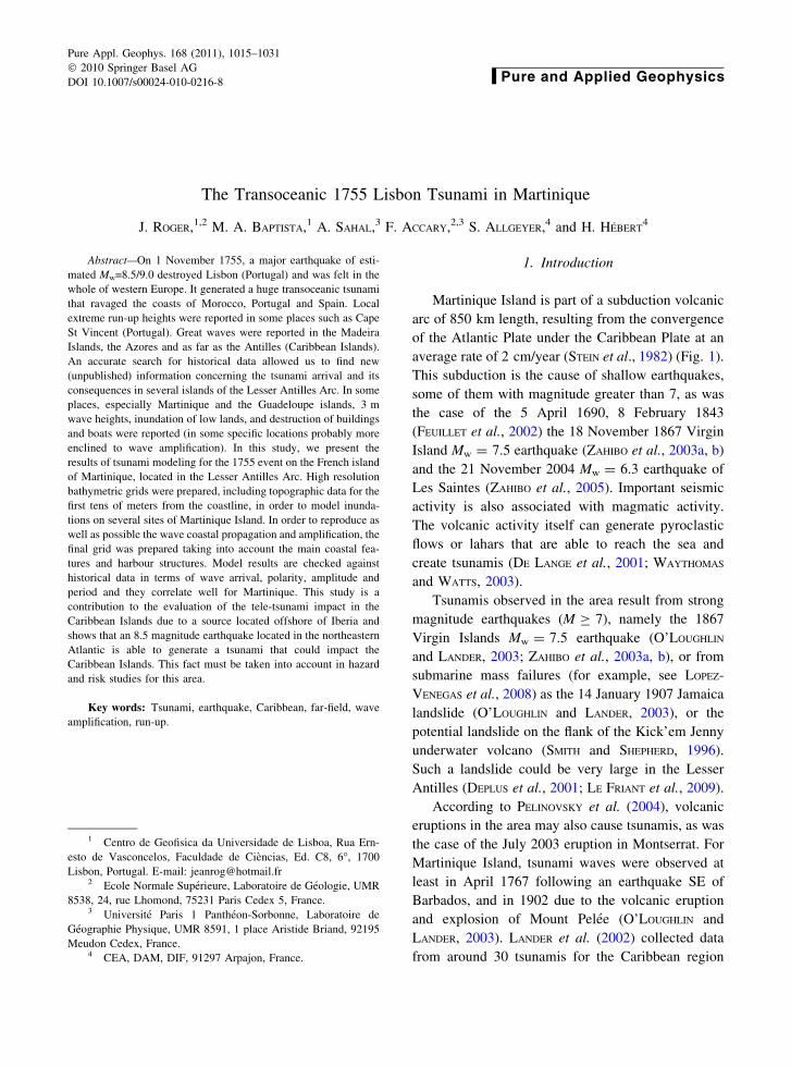
average rate of 2 cm/year (STEIN et al., 1982) (Fig. 1).
This subduction is the cause of shallow earthquakes,
some of them with magnitude greater than 7, as was
the case of the 5 April 1690, 8 February 1843
(FEUILLET et al., 2002) the 18 November 1867 Virgin
Island Mw = 7.5 earthquake (ZAHIBO et al., 2003a, b)
and the 21 November 2004 Mw = 6.3 earthquake of
Les Saintes (ZAHIBO et al., 2005). Important seismic
activity is also associated with magmatic activity.
The volcanic activity itself can generate pyroclastic
flows or lahars that are able to reach the sea and
create tsunamis (DE LANGE et al., 2001; WAYTHOMAS
and WATTS, 2003).
Tsunamis observed in the area result from strong
magnitude earthquakes (M C 7), namely the 1867
Virgin Islands Mw = 7.5 earthquake (O’LOUGHLIN
and LANDER, 2003; ZAHIBO et al., 2003a, b), or from
submarine mass failures (for example, see LOPEZ-
VENEGAS et al., 2008) as the 14 January 1907 Jamaica
landslide (O’LOUGHLIN and LANDER, 2003), or the
potential landslide on the flank of the Kick’em Jenny
underwater volcano (SMITH and SHEPHERD, 1996).
Such a landslide could be very large in the Lesser
Antilles (DEPLUS et al., 2001; LE FRIANT et al., 2009).
According to PELINOVSKY et al. (2004), volcanic
eruptions in the area may also cause tsunamis, as was
the case of the July 2003 eruption in Montserrat. For
Martinique Island, tsunami waves were observed at
least in April 1767 following an earthquake SE of
Barbados, and in 1902 due to the volcanic eruption
and explosion of Mount Pelee (O’LOUGHLIN and
LANDER, 2003). LANDER et al. (2002) collected data
from around 30 tsunamis for the Caribbean region
1 Centro de Geofisica da Universidade de Lisboa, Rua Ern-
esto de Vasconcelos, Faculdade de Ciencias, Ed. C8, 6�, 1700
Lisbon, Portugal. E-mail: [email protected] Ecole Normale Superieure, Laboratoire de Geologie, UMR
8538, 24, rue Lhomond, 75231 Paris Cedex 5, France.3 Universite Paris 1 Pantheon-Sorbonne, Laboratoire de
Geographie Physique, UMR 8591, 1 place Aristide Briand, 92195
Meudon Cedex, France.4 CEA, DAM, DIF, 91297 Arpajon, France.
Pure Appl. Geophys. 168 (2011), 1015–1031
� 2010 Springer Basel AG
DOI 10.1007/s00024-010-0216-8 Pure and Applied Geophysics
including local sources (source distance \200 km),
regional events (\1,000 km) and transoceanic events
([1,000 km). Among them, reliable sources report
observations for the 1755 Lisbon tsunami.
The tsunami observed in the Antilles at that time
has been associated with the great Lisbon earthquake
of November 1, 1755. This event was observed all
along the eastern Atlantic shores from Morocco to the
United Kingdom, and caused many casualties and
damage (BAPTISTA et al., 1998b, 2009a). In addition,
numerous coeval reports indicate important abnormal
waves in the Antilles.
Recent results of tsunami modeling show that an
earthquake with magnitude up to 8.0/8.5 with an epi-
center located offshore the Iberian Peninsula is indeed
able to produce significant wave heights in the western
Atlantic (BARKAN et al., 2009), and more particularly in
the coastal areas of Guadeloupe Island (ROGER et al.,
2010), 7 h 30 min of tsunami propagation after the
main shock (see tsunami travel times on Fig. 1).
Figure 1Geographic map locating Martinique Island (a) within the Lesser Antilles Arc (b) and in the North Atlantic Ocean (c). The tsunami travel
times (TTT), based on a point source (white star) close to the source of Baptista et al. (2003), are represented by continuous black curves
1016 J. Roger et al. Pure Appl. Geophys.

In order to shed some light on the event observed
in the French Antilles on 1 November 1755, we made
a detailed search for historical documents on these
islands and we present here a compilation of those
observations with focus on Martinique Island.
The main objective of this study is to test the
impact of a tsunami generated by a seismic source
proposed for the 1755 event using numerical mod-
eling and high resolution bathymetric data near the
coast. We investigate the tsunami far field propaga-
tion and the coastal wave amplification close to
Martinique Island. The results of numerical modeling
correlate well with the available historical data in
some selected sites in Martinique Island.
2. The 1755 Event
On 1 November 1755, a great earthquake of
estimated magnitude M = 8.5 ± 0.3 (SOLARES and
ARROYO, 2004) destroyed the town of Lisbon and was
felt in the whole of western Europe, as far east as
Hamburg (Germany). Compilations of historical data
concerning the earthquake are presented by SOUSA
(1919), MACHADO (1966), SOLARES and ARROYO
(2004), while compilations on tsunami data are pre-
sented in ROMERO (1992), BAPTISTA et al., (1998a,
2003), KAABOUBEN et al. (2009) and BARKAN et al.
(2009).
Several authors investigated the source of the
Lisbon earthquake, using either macroseismic data
(MACHADO, 1966; MARTINEZ SOLARES et al., 1979;
LEVRET, 1991; SOLARES et al., 2004), average tsunami
amplitudes (ABE, 1979), or scale comparisons with
the 28 February 1969 event (JOHNSTON, 1996). A
different approach was considered by BAPTISTA
(1998) and BAPTISTA et al. (1998a, b) throughout the
systematic study of the historical records of the 1755
tsunami wave heights observed along the Iberian and
Morocco coasts. These authors proposed a source
location, based on tsunami hydrodynamics modeling,
located close to the southwest Portuguese continental
margin. ZITELLINI et al. (1999) identified a very large
active, compressive, tectonic structure located
100 km offshore SW Cape St Vincent (Marques de
Pombal thrust fault) which was proposed as a good
candidate for the generation of the 1755 event,
although its dimensions cannot justify the seismic
moment of the 1755 earthquake. Later, BAPTISTA et al.
(2003) used this structure to build a composite source
and checked its reliability against the NE Atlantic
tsunami data.
An alternative solution was proposed by GUTSCHER
et al. (2002) as an active accretionary wedge overly-
ing an eastward dipping basement and connected to a
steep, east dipping slab of cold, oceanic lithosphere
beneath Gibraltar. Tsunami simulation results, using
this source geometry, are presented in GUTSCHER et al.
(2006). VILANOVA et al. (2003) considered an event
triggered in the Lower Tagus Valley as the source of
most of the damage observed close to Lisbon, and
even of some ‘‘tsunami like’’ phenomena described in
Oeiras and along the estuary of the Tagus River
(BAPTISTA and MIRANDA, 2009b). Recently, a new
source based on historical data in the NW Atlantic and
far-field tsunami modeling was proposed with an
orientation perpendicular to previously suggested
trending features (BARKAN et al., 2009).
2.1. Historical Data
2.1.1 Data Sources and Descriptions
The results of the research of historical data con-
cerning the observation of the 1755 tsunami in the
Caribbean are summarized in Table 1, showing that
the tsunami was observed on several islands, includ-
ing the French Antilles.
Most of these reports have been quoted in later
documents such as the Proces-Verbal des Seances de
l’Academie des Sciences of 1756 (ANONYMOUS, 1755;
LETTEE, 1755), or the supplement to the Gentleman’s
Magazine (URBAN, 1755). Most of the reports provide
information on the location of historical observations
(Table 1). Indeed, at this time, Martinique Island was
among the most important trade center, especially
Fort-de-France’s Bay, attended by experienced
sailors.
The accurate reading of these documents allows
us to conclude that there are only three distinct
sources of information: the first one is the letter read
by Duhamel concerning an anonymous witness
(ANONYMOUS, 1755); the second one is the letter of
LETTEE (1755); and the third one is the document
Vol. 168, (2011) The Transoceanic 1755 Lisbon Tsunami in Martinique 1017

Tab
le1
His
tori
cal
obse
rved
tsun
am
idata
inth
eL
esse
rA
nti
lles
for
1N
ove
mber
1755
even
t
Pla
ceL
on
.
(�W
)
Lat
.
(�N
)
Run
-up
(m)
Max
imu
m
inu
nd
atio
n
dis
tan
ce
(MID
)(m
)
Wit
hd
raw
al
dep
th(m
)
Wit
hd
raw
al
dis
tan
ce
(MW
D)
(m)
So
urc
e
Mar
tin
iqu
e
La
Tri
nit
e6
0.9
61
4.7
40
.6(3
),0
.9(2
),
1.2
a(4
,5
),9
.0(1
)
66
(2)
9.0
(1)
6b
(2),
66
(4,
5)
(1)
AN
ON
YM
OU
S(1
75
5),
(2)
LE
TT
EE
(17
55),
(3)
DA
NE
Y(1
84
6),
(4)
BR
UN
ET
(18
50),
(5)
BA
LL
ET
(18
96)
Le
Gal
ion
60.9
214.7
3M
inor
effe
cts
BR
UN
ET
(18
50),
BA
LL
ET
(18
96)
Le
Ro
ber
t6
0.9
41
4.6
8N
oth
ing
ob
serv
edB
RU
NE
T(1
85
0),
BA
LL
ET
(18
96)
Sa
inte
-Mar
ie6
0.9
91
4.7
8B
RU
NE
T(1
85
0),
BA
LL
ET
(18
96)
Sai
nt-
Fra
nco
is
(act
ual
Le
Fra
nco
is)
60
.89
14
.62
Just
men
tio
ned
AN
ON
YM
OU
S(1
75
5)
Lam
enti
n’s
riv
er6
1.0
11
4.6
0T
he
sea
rise
up
inth
eri
ver
s
circ
a0
.9m
mo
reth
ann
orm
al
BR
UN
ET
(18
50),
BA
LL
ET
(18
96)
Fo
rtR
oy
al’s
riv
er
(act
ual
Fo
rt-d
e-F
ran
ce)
61
.06
14
.60
BR
UN
ET
(18
50),
BA
LL
ET
(18
96)
Ep
inet
te’s
riv
er6
0.9
61
4.7
35
DA
NE
Y(1
84
6),
BR
UN
ET
(18
50),
BA
LL
ET
(18
96)
Mar
tin
iqu
e6
1.0
01
4.6
0Ju
stm
enti
on
edA
FF
LE
CK
(17
56)
Gu
adel
ou
pe
Sai
nt-
Ann
e6
1.3
81
6.2
23
.2*
22
0*
60
0*
BA
LL
ET
(18
96)
Bar
bad
os
Car
lisl
eB
ay5
9.0
11
3.0
8A
FF
LE
CK
(17
56)
Bar
bad
os
59
.55
13
.16
3.8
(6)
(6)
AF
FL
EC
K(1
75
6),
(7)
UR
BA
N
(17
55),
(8)
AN
ON
YM
OU
S(1
75
6)
An
tig
ua
61
.80
17
.07
1.2
(7)–
3.8
(6)
1.8
(6)
AF
FL
EC
K(1
75
6,
(7)
UR
BA
N(1
75
5)
Sab
ia6
3.2
31
7.6
36
.3A
FF
LE
CK
(17
56
St.
Mar
tin
63
.05
18
.05
4.5
cA
FF
LE
CK
(17
56
Th
eit
alis
ized
entr
ies
indic
ate
the
pla
ces
wh
ere
no
thin
gw
aso
bse
rved
.T
he
con
ver
sio
nb
etw
een
the
his
tori
cal
mea
sure
sF
ren
chP
as
du
Ro
yan
dm
eter
sis
1p
asd
uR
oy
=1
5/1
6E
ng
lish
foo
t=
0.3
24
m.
Th
en
um
ber
sw
ith
inb
rack
ets
refe
rto
the
info
rmat
ion
sou
rce
*In
dic
ates
val
ues
mea
sure
din
situ
and
ded
uce
do
nm
aps
acco
rdin
gto
his
tori
cal
ob
serv
atio
ns
(th
isco
nce
rns
on
lyG
uad
elo
up
e)a
Val
ue
giv
enab
ov
eth
eh
igh
tid
esb
Th
isv
alu
efr
om
LE
TT
EE,
17
55
cou
ldb
eb
oth
the
wit
hd
raw
ald
ista
nce
or
the
wit
hd
raw
ald
epth
cR
epo
rto
fa
bo
atm
oo
red
in4
.5m
of
wat
erth
atfa
lls
on
the
side:
the
wit
hd
raw
ald
epth
cou
ldb
em
ore
or
less
imp
ort
ant
1018 J. Roger et al. Pure Appl. Geophys.

certainly used by DANEY (1846), BRUNET (1850) and
BALLET (1896).
However, this third document is by far the richest
one with respect to the tsunami. It is a very precise
description of the hydrological phenomenon, focus-
ing especially on La Trinite Bay, describing the
various oscillations of the sea level: the succession of
flows and withdrawals, amplitudes, periods, etc. In
most records, the arrival of several waves is men-
tioned (actually flow and withdrawal), the first one
not always being the strongest. The same document
also informs us about the observation or the non-
observation of these same wave-trains around the
island: limited at Le Galion Bay, nothing at either Le
Robert or in St Marie, an ‘‘unusual deposit’’ by the
sea in the Epinette River, and specific responses of
the Lamentin and the Fort-Royal Rivers (west coast)
are also mentioned. These locations are indicated on a
British marine map of this period (Fig. 2).
The letter read by Duhamel (ANONYMOUS, 1755)
indicates that the sea reached about 9 m (30 ft, in the
original) above its usual level four times. The
phenomenon was observed from La Trinite Bay to
the Francois Cul-de-sac. LETTEE (1755) indicates that
the phenomenon started at 4 p.m. at La Trinite Bay,
beginning with a 6-meter drop of the sea level (20 ft,
in the original), flooding the shore 60 m inland
(200 ft, in the original), damaging houses up to 1 m
from the ground. It took 30 min for the sea level to
return to normal.
Concerning the other islands of the Antilles
(Barbados, Guadeloupe, Saba and St Martin, located
on Fig. 1), we can find some information about the
inundation of docks in harbors, streets, houses and
other.
We tried to read/interpret all this information in
terms of tsunami parameters. All details concerning
the number of waves, the period, and the height are
summarized in Table 1.
2.2. Studied Sites in Martinique
The studied sites are presented in Fig. 2. These
are La Trinite Bay, located on the east coast of the
Figure 2Geographical location of the historical observations and studied sites on Martinique Island on an historical map of Martinique and Guadeloupe
Islands (BELL, 1759, Courtesy of J. Bodington.)
Vol. 168, (2011) The Transoceanic 1755 Lisbon Tsunami in Martinique 1019

island, and Fort-de-France Bay, on the west coast of
the island, presenting a special focus on the harbor
(already here in 1755) and the international airport of
Le Lamentin.
A few other sites, mentioned in the historical
reports, are also analyzed: Ste-Marie, Le Galion Bay,
Le Robert, St-Francois. These sites are presented in
Fig. 2.
3. Tsunami Modeling
3.1. The Model Earthquake
The model earthquake used in this study for the
1755 earthquake is the double segment source
proposed by BAPTISTA et al. (2003), that includes
the Marques de Pombal thrust fault (MPTF) identified
by ZITELLINI et al. (1999), and a second thrust fault
oriented along the Guadalquivir Bank (GB).
They are included in Fig. 1 (as a point source) and
their parameters, presented in Table 2, account for
a Mw 8.5 earthquake with a seismic moment of
Mo = 6.63 9 1021 N m.
The selection of this model earthquake was based
upon two facts: (1) GUTSCHER et al. (2002)’s proposed
source produces late tsunami arrivals in the near field
(GUTSCHER et al., 2006); (2) BARKAN et al. (2009)’s
source is not a tectonic based source and its direction
cuts the most prominent structures in the area, although
it is able to radiate energy towards the Caribbean.
3.2. Numerical Method
The numerical model used in this study is based
on the non linear shallow water wave theory. It
allows us to compute tsunami generation and prop-
agation associated with an earthquake and has been
used for years in order to study tsunami hazards for
various exposed regions, from French Polynesia
(SLADEN et al., 2007) to the Mediterranean Sea
(ALASSET et al., 2006; ROGER and HEBERT, 2008;
YELLES-CHAOUCHE et al., 2009; SAHAL et al., 2009).
Our method assumes instantaneous displacement
of the sea surface, identical to the vertical sea-bottom
deformation, transmitted without losses to the entire
water column; the vertical sea-bottom deformation is
computed using the elastic dislocation model of
OKADA (1985). Given the initial free surface eleva-
tion, the model solves the hydrodynamical equations
of continuity (1) and momentum (2). Non linear
terms are taken into account, and the resolution is
carried out using a finite difference method centred in
time and using an upwind scheme in space.
The inundation is calculated based on the meth-
odology presented by KOWALIK and MURTY (1993),
relying on an extrapolation of the fluxes calculated in
wet cells and in dry meshes:
oðgþ hÞot
þr½vðgþ hÞ� ¼ 0 ð1Þ
ov
otþ ðvrÞv ¼ �grg ð2Þ
g corresponds to the water elevation, h to the
water depth, v to the horizontal velocity vector, g to
the gravity acceleration.
3.3. Bathymetric Grids
The wave propagation is calculated from the
epicenter area offshore of the Iberian Peninsula
(southern Portugal and Spain to the east) across the
Atlantic Ocean on six levels of imbricated grids of
increasing resolution, approaching the Lesser Antilles
including Martinique Island with special focus on La
Trinite Bay and Fort-de-France Bay. The largest grid
(grid 0, level 1), corresponding to the geographical
Table 2
Parameters of the two source segments used for tsunami modeling
Source Lon.
(�)
Lat.
(�)
Depth of
center of fault
plane (km)
Average
slip (m)
Strike
(�)
Dip
(�)
Rake/slip
angle (�)
Length
(km)
Width
(km)
Rigidity
(N m2)
Mo
(N m)
BAPTISTA et al.
(2003)
GB -8.7 36.1 20.5 20 250 45 90 105 55 30.0 109 3.46 1021
MPTF -10 36.8 20.5 20 21.7 24 90 96 55 30.0 109 3.17 1021
1020 J. Roger et al. Pure Appl. Geophys.
coordinates of Fig. 1a, is built from GEBCO World
Bathymetric Grid 10 (IOC, IHO and BODC, 2003)
and is just a resampling of this grid at a space step of
50 (*9,250 m). The grid resolution increases close to
the studied site in order to account for a correct
description of shorter wavelengths. Indeed, the wave
celerity is expressed by c ¼ffiffiffiffiffi
ghp
(in shallow water
non dispersive assumption), and thus decreases when
h decreases near the coast, implying wave shortening.
The time step used to solve the equations decreases
when the grid step decreases, and respects for each
grid level the Courant-Friedrichs-Lewy (CFL) crite-
rion to ensure the numerical stability. The resolution
for the levels 2 (grid 1), 3 (grid 2), 4 (grid 3), 5 (grid 4)
and 6 (grid 5 and 6) are, respectively, 10 (1,850 m),
500, 150, 40 and 20 m. The highest resolution grids
(levels 5 and 6), 40 and 20 m, correspond to the
zooms on La Trinite Bay and the northern part
of Fort-de-France Bay including the harbor and
Lamentin International Airport. The bathymetric
dataset was obtained through the merging of GEBCO
10 data, high resolution multi-beam and resampled
bathymetric data from the French Hydrographic
Service (SHOM). The intermediate grids (1–4) have
been included for numerical stability reasons and
correct wavelength sampling during the imbrication.
In order to compute tsunami propagation on land,
topographic data were manually digitized from
topographic maps published by IGN (2006a, b, c).
4. Modeling Results and Comparison with Historical
Data
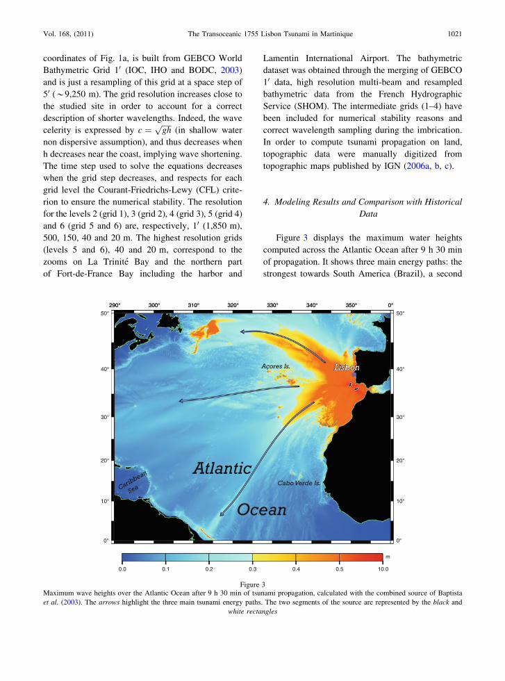
Figure 3 displays the maximum water heights
computed across the Atlantic Ocean after 9 h 30 min
of propagation. It shows three main energy paths: the
strongest towards South America (Brazil), a second
290° 300° 310° 320° 330° 340° 350° 0°
0° 0°
10° 10°
20° 20°
30° 30°
40° 40°
50° 50°
0.0 0.1 0.2 0.3 0.4 0.5 10.0
m
290° 300° 310° 320° 330° 340° 350° 0°
Figure 3Maximum wave heights over the Atlantic Ocean after 9 h 30 min of tsunami propagation, calculated with the combined source of Baptista
et al. (2003). The arrows highlight the three main tsunami energy paths. The two segments of the source are represented by the black and
white rectangles
Vol. 168, (2011) The Transoceanic 1755 Lisbon Tsunami in Martinique 1021

towards Newfoundland and the weakest towards the
USA (Florida). This radiation pattern is due to the
geometrical shape of the source and its azimuth, and
to the most relevant submarine features (submarine
basins, ridges and transform faults, for example)
along the oceanic path that will act as waveguides
during tsunami propagation as noted by SATAKE
(1988), HEBERT et al. (2001) and TITOV et al. (2005).
It is worth noting that the Caribbean area is not
among the most impacted areas for this computed
tele-tsunami on this large-scale grid.
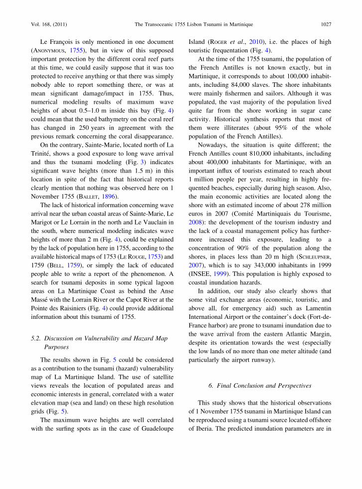
In Fig. 4, we present the maximum wave heights
along Martinique Island (grid 2, resolution 500 m and
grid 3, resolution 150 m) obtained after 9 h 30 min of
tsunami propagation. It clearly shows that only a few
sites are prone to wave amplification around the
island. This corresponds to sites either directly
exposed to long wave arrival coming from the Iberian
Peninsula or also located on the other side of the
island, in the Caribbean Sea. The wave heights
observed along the coast of Martinique vary between
1 and 2 m. The coastal segment from the bay of La
Trinite and the north coast of the neighboring Pres-
qu’ıle de la Caravelle to the north of the island near
Le Lorrain exhibits maximum values of more than
2 m. Along the southeast coast, the bays of Le
Galion, Le Robert and Le Francois, the wave heights
are generally less significant. Then the southeastern
coast of the island, offshore of Le Vauclun, shows
again significant wave heights of more than 1.5 m.
The potential protective role of the fragmented
coral reef barrier from Le Vauclun to Le Galion
(shown in Fig. 4) against long wave arrivals has to be
stressed. The display of the maximum tsunami height
with a shaded bathymetric gradient shows a relative
protection of the coastal sites by the coral reef, on the
southeastern part of the island. This residual coral
reef (appearing as a line on the right) leads to an
attenuation of the tsunami effect for the thus-
protected bays of Le Galion, Le Robert and Le
Francois. The northeastern (La Trinite, Ste Marie, Le
Lorrain) and southern part of the island, which are
probably not protected enough by the coral reef
which is too deep (5–10 m under sea level), shows
again some significant wave heights, at the northern
part of the island, from La Trinite to Le Lorrain and
farther north.
The surfing spots indicated in Fig. 4 highlight the
coastal areas not protected by a sufficient coral reef
barrier against classic wind long waves.
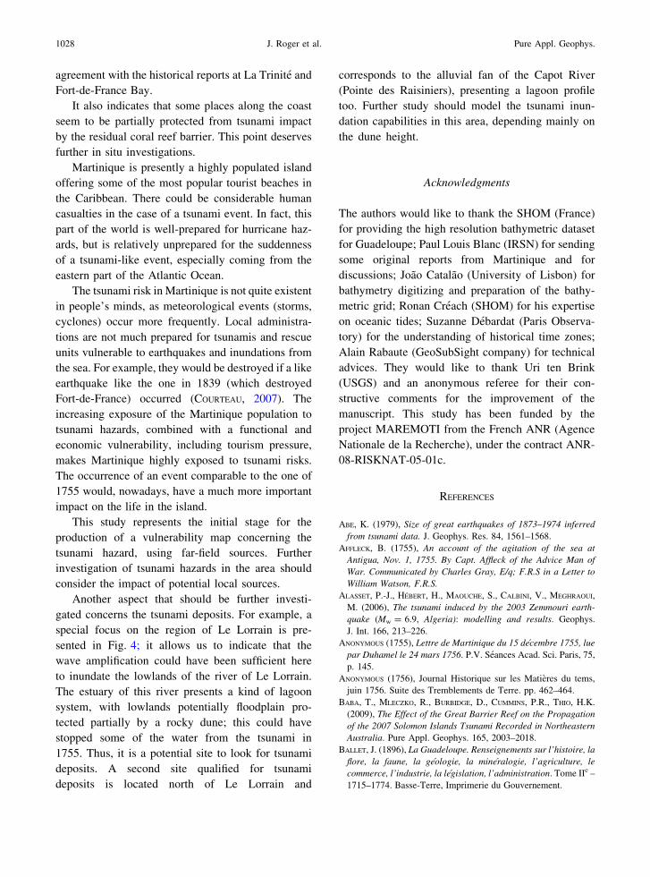
Figure 5 (grid 5 and 6) present a focus on the
specific site of La Trinite Bay and Fort-de-France
Bay and neighboring areas after 9 h 30 min of tsu-
nami propagation. It shows the maximum water
height reached by the sea level and the flow depth
(maximum wave height minus topography) on land.
The high resolution (20 and 40 m) grids of La
Trinite and Fort-de-France Bays (Fig. 5) are able to
reproduce the segments of this coral reef barrier, the
harbour morphology and coastal shapes as well as the
shallow bathymetric features that could affect sig-
nificantly tsunami propagation near the coast and
might contribute to wave trapping and amplifications,
potentially associated with resonance phenomena
(ROGER et al., 2010).
We can clearly see that several places are inun-
dated in both grids, sometimes until several hundreds
of meters from the shore: until 100 m in La Trinite
and 250 m in La Moıse, on the east side of La Trinite
Bay; and until more than 1 km in Fort-de France Bay
(near the airport). This inundation is especially sig-
nificant all around La Trinite Bay where we can find
flow depth values of more than 2 m in the town but
also in other urban areas such as La Clique and Anse
Cosmy (north of La Trinite) and La Moıse, on the
eastern side of the bay (Fig. 5). The 9 m (30 ft) wave
height value indicated in ANONYMOUS (1755)
(Table 1) is probably a mistake; it is likely between 3
and 30 ft if we refer to the other descriptions at La
Trinite (LETTEE, 1755; DANEY, 1846; BRUNET, 1850;
BALLET, 1896). The presented results show a maxi-
mum inundation distance (MID) of about 100 m in
the southern part of the bay (the town of La Trinite),
and 250 m in the northeastern area (Anse Cosmy);
thus, longer than the historical observations. How-
ever, this computed inundation limit may be
overestimated due to the fact that friction is not
considered and this may be important in urban areas.
Concerning Fort-de-France Bay (grid 6), the wave
heights are smaller than in La Trinite (by about a
factor of 3), but they can reach 1.5 m offshore of Fort
St-Louis and in the inlet of Chateau Lezards, deep
inside of the bay, south of the airport of Le Lamentin.
In addition, several places exhibit inundation, in the
1022 J. Roger et al. Pure Appl. Geophys.

Figure 4Maximum wave heights illuminated by a bathymetric gradient on Martinique Island on grid 2 and 3 after 9 h 30 min of tsunami propagation
using Baptista et al. (2003)’s seismic source. The yellow dots are the places mentioned in the text. The red rectangles show the location of the
different imbricated grids. A focus (black rectangle on grid 3) shows evidence of wave amplification offshore of a lagoon domain (Anse
Masse) southwestward to Le Lorrain. The residual coral reef barrier is indicated with dashed pink curve (from Battistini, 1978). The main
surfing spots are indicated by green hexagons (from http://www.wannasurf.com)
Vol. 168, (2011) The Transoceanic 1755 Lisbon Tsunami in Martinique 1023

Fort-de-France town center, which is very low and in
the area of the container dock, but also the areas close
to the canal of Le Lamentin and the Lezarde River,
close to the airport, which are partially inundated. All
these inundations in Fort-de-France Bay happen in
low lands and mostly in swamps with maximum
wave heights of no more than 50 cm. This is in good
agreement with the historical data indicating that the
Lamentin River, located north of the Airport, was
subject to an abnormal phenomenon on 1 November
-60°57'36"
14°44'24" 14°44'24"
14°45'36" 14°45'36"
0.0 0.5 1.0 1.5 2.0 2.5 3.0 3.5 4.0 4.5 5.0
m
-61°04'48" -61°03'36" -61°02'24" -61°01'12" -61°00'00" -60°58'48"
14°34'48" 14°34'48"
14°36'00" 14°36'00"
14°37'12" 14°37'12"
14°38'24" 14°38'24"
0.0 0.5 1.0 1.5
m
Figure 5Maximum wave heights illuminated by a bathymetric gradient at sea and maximum water depth on land in high resolution grids 5 and 6 after
9 h 30 min of tsunami propagation. The red line underlines the inundation limit. The red crosses represent the synthetic tide gauges location.
The altitude limits of 0 and 10 m are indicated, respectively, by black and yellow lines
1024 J. Roger et al. Pure Appl. Geophys.

1755 with the sea rising up in the rivers 3 feet
(*90 cm) more than normal (BALLET, 1896).
Synthetic tide gauges have been positioned
(Fig. 5) in order to obtain information concerning
principally tsunami arrival, wave polarities, ampli-
tude and periods at specific locations in both bays.
Figure 6 represents the synthetic signal recorded
by two synthetic tide gauges located on both sides of
the island, one in La Trinite Bay and one in Fort-de-
France Bay. It shows that the effects of the tsunami
would be less dramatic in Fort-de-France Bay than
they would be in La Trinite Bay at approximately the
same water depth (*10 m). Then it indicates that the
first tsunami wave arrives in La Trinite Bay within a
travel time of about 7 h 30 min. This is in agreement
with the time announced in the available historical
documents.
Concerning La Trinite, the computed polarity and
the relative amplitudes are in agreement with the
reported historical facts: there is a small sea elevation
of 70 cm (reported to be 60 cm above the maximum
tide level) followed by an significant withdrawal in
about 10 min (reported to occur in 4 min) and then a
significant inundation of the docks and the streets. The
time between the first two waves has been estimated to
be 15 min. The computed time between these two
waves is around 20 min. According to BALLET
(1896)’s accurate description of the phenomenon in
La Trinite, we are globally in good agreement con-
cerning periods and relative amplitude between each
wave, except for the position of the most significant
and destructive wave: it is reported to be the fourth
one (BALLET, 1896) but the results of computation
show that it is the fifth (Fig. 6).
5. Discussion
The effects of the tide and friction have not been
considered in this study.
The historical tide prediction (done using the
actual mean sea level with data from 1980–1985 for
Le Robert and data from 2005–2008 for Fort-de-
France) on 1 November 1755 for Le Robert indicate
that, despite the fact that the amplitude of tide was
only of about 40 cm crest to trough, the sea was up or
at the beginning of withdrawal at 2 p.m., the hour of
arrival of the tsunami according to the historical
documents. For data concerning Fort-de-France, the
amplitude of tide has been estimated to be less than
20 cm crest to trough. In both cases, this tide
amplitude certainly could have had an additional
effect on the tsunami coastal amplification and
inundation, even a negligible effect regarding the
tsunami height of more than 3 m in La Trinite Bay.
The simulations have been done without taking
into account the friction effects. Even though DOTS-
ENKO (1998) shows that the dissipation due to friction
effects is negligible offshore (open-sea and shelf
areas), DAO and TKALICH (2007) show that the
roughness parameter is important in wave-shore
interaction including shallow water and inundation
friction. This is something important to be noted
because it means that, in our case, the friction term is
equal to 0 and, thus, the run-up limits presented in the
following are certainly overestimated regarding the
computed scenarios. In fact, if the friction is impor-
tant due to the presence of lots of buildings or dense
vegetation, for example, so the propagation on land
will be slowed down more quickly than without
buildings (YANAGASIWA et al., 2009). According to
HEBERT et al. (2009) the non consideration of friction
could correspond to an overestimation of wave
heights of about 30%.
360 420 480 540-2,5
-2,0
-1,5
-1,0
-0,5
0,0
0,5
1,0
1,5
2,0
Am
plitu
de (
m)
Time (min)
synthetic tide gage Fort de France (10.63)synthetic tide gage La Trinité (9.47 m)
Figure 6Synthetic maregrams obtained after 9 h 30 min of tsunami
propagation for two synthetic tide gauges located in the bays of
La Trinite and Fort-de-France. Their positions are given in Fig. 4.
The water depth at the gauge location is indicated
Vol. 168, (2011) The Transoceanic 1755 Lisbon Tsunami in Martinique 1025
5.1. Role of Coastal Features
It is important to try to reproduce as well as
possible the coastal and bathymetric features in low
water depth, i.e. in the area of wave shoaling and
refraction processes around seafloor topographic
highs, because the particular characteristics of the
coastline (coastal geo-morphology, e.g. the geometry
of bays, harbours, slope of beaches), or the presence
of submarine canyons or coral reef barriers, will have
direct consequences on the wave behavior and
amplification factor and on the inundation or run-up
(CHATENOUX and PEDUZZI, 2005, 2007; COCHARD et al.,
2008; DUONG et al., 2008).
In the same way, as underlined by ROGER and
HEBERT (2008) for the Balearic Islands in the
Mediterranean Sea, the knowledge of the location
of submarine canyons is important to assess the
tsunami hazard along the coasts because of the
focusing role they can play on long wavelengths.
Thus, the impact on long waves of the submarine
canyons located a few kilometers from the shore in
the southeastern part of the island (Fig. 3) should be
determined in the future, especially if the coral reef,
actually acting as a shield, is going to disappear.
Thus, La Trinite is a U-shaped bay (or funnel-
shaped bay), with a maximum length of about 1.2 km
and a maximum width of about 1.0 km, oriented N–S
and opened northward with a mean depth of 4 m and
a very low bathymetric slope (0.33�). This shape is
particularly interesting to consider in the case of
tsunami wave amplification studies and hazard
assessment. In fact, this apparently protected bay
with a narrow inlet can amplify the tsunami, and thus
its destructive power, presenting a funnel-shape for
the arrival waves to travel through (MONSERRAT et al.,
2006). This could explain the observed and modeled
wave amplification at this specific location. In
addition, it is important to mention that the coral
reef barrier in front of this bay could be qualified as
residual, i.e. not able to protect the bay against long
wave arrival because it is too deep and cut. This
situation is emphasized by the high touristic fre-
quentation all year long, especially for this location.
Fort-de-France is located eastward of swamp-
lands, lowlands bordering the Lamentin River, and is
constantly inundated with a mean altitude of less than
1 m above sea level. In spite of the fact that the
historical reports do not mention any catastrophic
wave arrival in Fort-de-France Bay in these places in
1755, the present vulnerability of the area should be
taken into account because of its economical central
role, located in lowland areas. This omega-shaped
(X) bay (9 km length and 3 km width in the
narrowest place) is oriented E–W and opened
westward. Its maximum water depth is about 30 m
in the boats channel to the harbor but elsewhere it is
only about 10 m deep at most. The general bathy-
metric slope of the bay from the east (Lamentin
Airport) to the west (entrance of the bay) is less than
0.1�.
Several authors have referred to the effects of the
presence of coral reef barriers close to the coast, such
as the increase in the propagation time, and the
reduction of the amplitude (BABA et al., 2009). But on
the other side, COCHARD et al. (2008) indicate that
when fragmented, waves are able to accelerate
through so-created channels.
For Martinique Island, Fig. 4 shows that the coral
reef barrier could be qualified as residual; only a line
of 25 km length between the presqu’ıle de la
Caravelle and Le Vauclin is visible. The progressive
disappearance of the coral reef in Martinique is due to
geological reasons such as fast subsidence or volcanic
eruptions (BATTISTINI, 1978), and to human stresses
such as the pollution or the overfishing in these rich
areas (BOUCHON et al., 2008; LEGRAND et al., 2008).
This happens in particular offshore of the north-
east coast where the reef does not protect from the
assault of normal waves because it is generally
underwater at 5–10 m depth (BATTISTINI, 1978) as
shown in Fig. 4 with the location of surfing spots. In
fact, only the southeastern part of the reef remains,
partially protecting the coast from classical waves,
with a width sprawl of about 1–2 km; three of the
sites discussed in this paper are affected: the bays of
Le Galion, Le Robert and Le Francois. In 1755,
according to the historical documents, we know that
nothing was observed in Le Robert and just a little in
Le Galion (BALLET, 1896). Despite the fact that we
have not tested the real effect of this coral barrier, the
general results obtained with maximum wave heights
in the case of the 1755 event are in favor of this.
1026 J. Roger et al. Pure Appl. Geophys.
Le Francois is only mentioned in one document
(ANONYMOUS, 1755), but in view of this supposed
important protection by the different coral reef parts
at this time, we could easily suppose that it was too
protected to receive anything or that there was simply
nobody able to report something there, or was at
mean significant damage/impact in 1755. Thus,
numerical modeling results of maximum wave
heights of about 0.5–1.0 m inside this bay (Fig. 4)
could mean that the used bathymetry on the coral reef
has changed in 250 years in agreement with the
previous remark concerning the coral disappearance.
On the contrary, Sainte-Marie, located north of La
Trinite, shows a good exposure to long wave arrival
and thus the tsunami modeling (Fig. 3) indicates
significant wave heights (more than 1.5 m) in this
location in spite of the fact that historical reports
clearly mention that nothing was observed here on 1
November 1755 (BALLET, 1896).
The lack of historical information concerning wave
arrival near the urban coastal areas of Sainte-Marie, Le
Marigot or Le Lorrain in the north and Le Vauclain in
the south, where numerical modeling indicates wave
heights of more than 2 m (Fig. 4), could be explained
by the lack of population here in 1755, according to the
available historical maps of 1753 (LE ROUGE, 1753) and
1759 (BELL, 1759), or simply the lack of educated
people able to write a report of the phenomenon. A
search for tsunami deposits in some typical lagoon
areas on La Martinique Coast as behind the Anse
Masse with the Lorrain River or the Capot River at the
Pointe des Raisiniers (Fig. 4) could provide additional
information about this tsunami of 1755.
5.2. Discussion on Vulnerability and Hazard Map
Purposes
The results shown in Fig. 5 could be considered
as a contribution to the tsunami (hazard) vulnerability
map of La Martinique Island. The use of satellite
views reveals the location of populated areas and
economic interests in general, correlated with a water
elevation map (sea and land) on these high resolution
grids (Fig. 5).
The maximum wave heights are well correlated
with the surfing spots as in the case of Guadeloupe
Island (ROGER et al., 2010), i.e. the places of high
touristic frequentation (Fig. 4).
At the time of the 1755 tsunami, the population of
the French Antilles is not known exactly, but in
Martinique, it corresponds to about 100,000 inhabit-
ants, including 84,000 slaves. The shore inhabitants
were mainly fishermen and sailors. Although it was
populated, the vast majority of the population lived
quite far from the shore working in sugar cane
activity. Historical synthesis reports that most of
them were illiterates (about 95% of the whole
population of the French Antilles).
Nowadays, the situation is quite different; the
French Antilles count 810,000 inhabitants, including
about 400,000 inhabitants for Martinique, with an
important influx of tourists estimated to reach about
1 million people per year, resulting in highly fre-
quented beaches, especially during high season. Also,
the main economic activities are located along the
shore with an estimated income of about 278 million
euros in 2007 (Comite Martiniquais du Tourisme,
2008): the development of the tourism industry and
the lack of a coastal management policy has further-
more increased this exposure, leading to a
concentration of 90% of the population along the
shores, in places less than 20 m high (SCHLEUPNER,
2007), which is to say 343,000 inhabitants in 1999
(INSEE, 1999). This population is highly exposed to
coastal inundation hazards.
In addition, our study also clearly shows that
some vital exchange areas (economic, touristic, and
above all, for emergency aid) such as Lamentin
International Airport or the container’s dock (Fort-de-
France harbor) are prone to tsunami inundation due to
the wave arrival from the eastern Atlantic Margin,
despite its orientation towards the west (especially
the low lands of no more than one meter altitude (and
particularly the airport runway).
6. Final Conclusion and Perspectives
This study shows that the historical observations
of 1 November 1755 tsunami in Martinique Island can
be reproduced using a tsunami source located offshore
of Iberia. The predicted inundation parameters are in
Vol. 168, (2011) The Transoceanic 1755 Lisbon Tsunami in Martinique 1027
agreement with the historical reports at La Trinite and
Fort-de-France Bay.
It also indicates that some places along the coast
seem to be partially protected from tsunami impact
by the residual coral reef barrier. This point deserves
further in situ investigations.
Martinique is presently a highly populated island
offering some of the most popular tourist beaches in
the Caribbean. There could be considerable human
casualties in the case of a tsunami event. In fact, this
part of the world is well-prepared for hurricane haz-
ards, but is relatively unprepared for the suddenness
of a tsunami-like event, especially coming from the
eastern part of the Atlantic Ocean.
The tsunami risk in Martinique is not quite existent
in people’s minds, as meteorological events (storms,
cyclones) occur more frequently. Local administra-
tions are not much prepared for tsunamis and rescue
units vulnerable to earthquakes and inundations from
the sea. For example, they would be destroyed if a like
earthquake like the one in 1839 (which destroyed
Fort-de-France) occurred (COURTEAU, 2007). The
increasing exposure of the Martinique population to
tsunami hazards, combined with a functional and
economic vulnerability, including tourism pressure,
makes Martinique highly exposed to tsunami risks.
The occurrence of an event comparable to the one of
1755 would, nowadays, have a much more important
impact on the life in the island.
This study represents the initial stage for the
production of a vulnerability map concerning the
tsunami hazard, using far-field sources. Further
investigation of tsunami hazards in the area should
consider the impact of potential local sources.
Another aspect that should be further investi-
gated concerns the tsunami deposits. For example, a
special focus on the region of Le Lorrain is pre-
sented in Fig. 4; it allows us to indicate that the
wave amplification could have been sufficient here
to inundate the lowlands of the river of Le Lorrain.
The estuary of this river presents a kind of lagoon
system, with lowlands potentially floodplain pro-
tected partially by a rocky dune; this could have
stopped some of the water from the tsunami in
1755. Thus, it is a potential site to look for tsunami
deposits. A second site qualified for tsunami
deposits is located north of Le Lorrain and
corresponds to the alluvial fan of the Capot River
(Pointe des Raisiniers), presenting a lagoon profile
too. Further study should model the tsunami inun-
dation capabilities in this area, depending mainly on
the dune height.
Acknowledgments
The authors would like to thank the SHOM (France)
for providing the high resolution bathymetric dataset
for Guadeloupe; Paul Louis Blanc (IRSN) for sending
some original reports from Martinique and for
discussions; Joao Catalao (University of Lisbon) for
bathymetry digitizing and preparation of the bathy-
metric grid; Ronan Creach (SHOM) for his expertise
on oceanic tides; Suzanne Debardat (Paris Observa-
tory) for the understanding of historical time zones;
Alain Rabaute (GeoSubSight company) for technical
advices. They would like to thank Uri ten Brink
(USGS) and an anonymous referee for their con-
structive comments for the improvement of the
manuscript. This study has been funded by the
project MAREMOTI from the French ANR (Agence
Nationale de la Recherche), under the contract ANR-
08-RISKNAT-05-01c.
REFERENCES
ABE, K. (1979), Size of great earthquakes of 1873–1974 inferred
from tsunami data. J. Geophys. Res. 84, 1561–1568.
AFFLECK, B. (1755), An account of the agitation of the sea at
Antigua, Nov. 1, 1755. By Capt. Affleck of the Advice Man of
War. Communicated by Charles Gray, E/q; F.R.S in a Letter to
William Watson, F.R.S.
ALASSET, P.-J., HEBERT, H., MAOUCHE, S., CALBINI, V., MEGHRAOUI,
M. (2006), The tsunami induced by the 2003 Zemmouri earth-
quake (Mw = 6.9, Algeria): modelling and results. Geophys.
J. Int. 166, 213–226.
ANONYMOUS (1755), Lettre de Martinique du 15 decembre 1755, lue
par Duhamel le 24 mars 1756. P.V. Seances Acad. Sci. Paris, 75,
p. 145.
ANONYMOUS (1756), Journal Historique sur les Matieres du tems,
juin 1756. Suite des Tremblements de Terre. pp. 462–464.
BABA, T., MLECZKO, R., BURBIDGE, D., CUMMINS, P.R., THIO, H.K.
(2009), The Effect of the Great Barrier Reef on the Propagation
of the 2007 Solomon Islands Tsunami Recorded in Northeastern
Australia. Pure Appl. Geophys. 165, 2003–2018.
BALLET, J. (1896), La Guadeloupe. Renseignements sur l’histoire, la
flore, la faune, la geologie, la mineralogie, l’agriculture, le
commerce, l’industrie, la legislation, l’administration. Tome IIe –
1715–1774. Basse-Terre, Imprimerie du Gouvernement.
1028 J. Roger et al. Pure Appl. Geophys.
BAPTISTA, M.A. (1998), Genese propagacao e impacte de tsunamis
nas costas portuguesas. PHD Thesis, University of Lisbon,
Portugal (in Portuguese).
BAPTISTA, M.A., MIRANDA, J.M. (2009a), Revision of the Portuguese
catalog of tsunamis, Nat. Hazards Earth Syst. Sci. 9, 25–42.
http://www.nat-hazards-earth-syst-sci.net/9/25/2009/nhess-9-25-
2009.html
BAPTISTA, M.A., MIRANDA, J.M. (2009b), Evaluation of the 1755
Earthquake Source Using Tsunami Modeling, in Geotechnical,
Geological and Earthquake Engineering, Book Series, Vol. 7,
425–423: The 1755 Lisbon Earthquake Revisited. Springer,
Netherlands. ISBN:978-1-4020-8608-3.
BAPTISTA, M.A., HEITOR, S., MIRANDA, J.M., MIRANDA, P., and
MENDES-VICTOR, L. (1998a), The 1755 Lisbon tsunami; evalua-
tion of the tsunami parameters, J. Geodyn. 25, 143–157.
BAPTISTA, M.A., MIRANDA, P.M.A., MIRANDA, J.M., MENDES-VICTOR,
L. (1998b), Constrains on the source of the 1755 Lisbon tsunami
inferred from numerical modelling of historical data on the
source of the 1755 Lisbon tsunami. J. Geodyn. 25(1–2), 159–174.
BAPTISTA, M.A., MIRANDA, J.M., CHIERICCI, F., ZITELLINI, N. (2003),
New Study of the 1755 Earthquake Source Based on Multi-
channel Seismic Survey Data and Tsunami Modeling, Nat.
Hazards and Earth Syst. Sci. 3, 333–340.
BARKAN, R., BRINK, T. U., LIN, J. (2009), Far field tsunami simu-
lations of the 1755 Lisbon earthquake: implications for tsunami
hazard to the U.S. East Coast and the Caribbean. Mar. Geol.
264, 109–122.
BATTISTINI, R. (1978), Les recifs coralliens de la Martinique.
Comparaison avec ceux au sud-ouest de l’Ocean Indien. Cah.
O.R.S.T.O.M., ser. Oceanogr. Vol. XVI (2), 157–177.
BELL, A. (1759), Map of Martinico for the latest and best authorities.
Map of Guadalupe on a smaller scale. Scots Magazine. Available
at http://evo.bio.psu.edu/caribmap/lesser/bodington.htm
BOUCHON, C., PORTILLO, P., BOUCHON-NAVARO, Y., LOUIS, M.,
HOETJES, P., DE MEYER, K., MACRAE, D., ARMSTRONG, H., DATA-
DIN, V., HARDING, S., MALLELA, J., PARKINSON, R., VAN BOCHOVE,
J.-W., WYNNE, S., LIRMAN, D., HERLAN, J., BAKER, A., COLLADO,
L., NIMROD, S., MITCHELL, J., MORRALL, C., ISAAC, C. (2008),
Status of Coral Reefs of the Lesser Antilles: The French West
Indies, The Netherlands Antilles, Anguilla, Antigua, Grenada,
Trinidad and Tobago. In: Wilkinson, C et al. (eds) Status of coral
reefs of the world. Vol. 3, 265–280. Australian Institute of
Marine Sciences, Australia.
BRUNET, P. (attribue a -) (1850), ‘‘Journal d’un vieil habitant de
Sainte-Marie (1745–1765)’’ ou ‘‘Ephemerides d’un vieil habitant
de Sainte-Marie’’). Annexe in Rufz de Lavison, Etienne (Dr),
1850. Etudes historiques et Statistiques sur la Population de la
Martinique. St. Pierre. p. 394.
CHATENOUX, B., PEDUZZI, P. (2005), Analysis on the role of
bathymetry and other environmental parameters in the impacts
from the 2004 Indian Ocean Tsunami. A Scientific Report for
the UNEP Asian Tsunami Disaster Task Force. UNEP/GRID-
Europe. http://www.grid.unep.ch/product/publication/download/
environment_impacts_tsunami.pdf.
CHATENOUX, B., PEDUZZI, P. (2007), Impacts from the 2004 Indian
Ocean Tsunami: analyzing the potential protecting role of
environmental features. Nat. Hazards. 40, 289–304. doi:10.1007/
s11069-006-0015-9.
COCHARD, R., RANAMUKHAARACHCHI, S.L., SHIVAKOTI, G.P., SHIPIN,
O.V., EDWARDS, P.J., SEELAND, K.T., (2008), The 2004 tsunami in
Aceh and Southern Thailand: A review on coastal ecosystems,
wave hazards and vulnerability. Perspectives in Plant Ecology,
Evolution and Systematics. 10, 3–40.
COMITE MARTINIQUAIS DU TOURISME (2008), Bilan Grand Public. 9 p.
COURTEAU, R. (2007), Rapport sur l’evaluation et la prevention du
risque du tsunami sur les cotes francaises en metropole et outre-
mer. Office parlementaire d’evaluation des choix scientifiques et
technologiques, 168 p.
DANEY, S. (1846), Histoire de la Martinique depuis la colonisation
jusqu’en 1815; Par M. Sidney Daney, Membre du conseil colo-
nial de la Martinique, Tome III. Fort-Royal, E. Ruelle,
Imprimeur du Gouvernement. pp. 237–238.
DAO, M.H., TKALICH, P., (2007), Tsunami propagation model-
ling—a sensitivity study. Nat. Hazards Earth Syst. Sci. 7,
741–754.
DE LANGE, W.P., PRASETYA, G.S., HEALY, T.R. (2001), Modelling of
tsunamis generated by pyroclastic flows (ignimbrites). Natural
Hazards, 24(3), 251–266. doi:10.1023/A:1012056920155.
DEPLUS, C., LE FRIANT, A., BOUDON, G., KOMOROWSKI, J.-C.,
VILLEMANT, B., HARFORD, C., SEGOUFIN, J., CHEMINEE, J.-L. (2001),
Submarine evidence for large-scale debris avalanches in the
Lesser Antilles Arc. Earth Planet. Sci. Lett. 192, 145–157.
DOTSENKO, S.F. (1998), Numerical modelling of the propagation of
tsunami waves in the Crimean Peninsula shelf zone. Phys.
Oceanogr. 9(5), 323–331.
DUONG, N.A., KIMATA, F., MEILANO, I. (2008), Assessment of
Bathymetry Effects on Tsunami Propagation in Viet Nam. Adv.
Nat. Sci. 9(6).
FEUILLET, N., MANIGHETTI, I., TAPPONNIER, P., JACQUES, E. (2002),
Arc parallel extension and localization of volcanic complexes in
Guadeloupe, Lesser Antilles. J. Geophys. Res. 107(B12), 2331.
doi:10.1029/2001JB000308.
GUTSCHER, M.A., MALOD, J., REHAULT, J.P., CONTRUCCI, I., KLIN-
GELHOEFER, F., MENDES-VICTOR, L.A., SPAKMAN, W. (2002),
Evidence for active subduction beneath Gibraltar. Geology 30,
1071–1074.
GUTSCHER, M.-A., BAPTISTA, M.A., MIRANDA, J.M. (2006), The
Gibraltar Arc seismogenic zone (part 2): Constraints on a
shallow east dipping fault plane source for the 1755 Lisbon
earthquake provided by tsunami modeling and seismic intensity.
Tectonophysics 426, 153–166.
HEBERT, H., SCHINDELE, F., HEINRICH, P. (2001), Tsunami risk
assessment in the Marquesas Islands (French Polynesia) through
numerical modeling of generic far-field events. Nat. Hazards
Earth Syst. Sci. 1, 233–242.
HEBERT, H., REYMOND, D., KRIEN, Y., VERGOZ, J., SCHINDELE, F.,
ROGER J., LOEVENBRUCK, A. (2009), The 15 August 2007 Peru
earthquake and tsunami: influence of the source characteristics
on the tsunami heights. Pure Appl. Geophys. 166, 1–22.
INSEE (2009), Population et logements par commune depuis le
recensement de 1962 (1961 pour les Dom). Available on
http://www.insee.fr/fr/themes/detail.asp?reg_id=99&ref_id=poplog-
com.
INSTITUT GEOGRAPHIQUE NATIONAL (2006a), Fort-de-France,
Montagne Pelee, PNR de la Martinique. Carte de Randonnee,
4501 MT, edition 2, 1: 25000.
INSTITUT GEOGRAPHIQUE NATIONAL (2006b), Le Lamentin, presqu’ıle
de la Caravelle, PNR de la Martinique. Carte de Randonnee,
4502 MT, edition 2, 1: 25000.
INSTITUT GEOGRAPHIQUE NATIONAL (2006c), Le Marin, presqu’ıle des
trois ılets, PNR de la Martinique. Carte de Randonnee, 4503 MT,
edition 2, 1: 25000.
Vol. 168, (2011) The Transoceanic 1755 Lisbon Tsunami in Martinique 1029

IOC, IHO and BODC (2003), Centenary Edition of the GEBCO
Digital Atlas, published on CD-ROM on behalf of the Intergov-
ernmental Oceanographic Commission and the International
Hydrographic Organization as part of the General Bathymetric
Chart of the Oceans. British Oceanographic Data Centre, Liv-
erpool, UK.
JOHNSTON, A. (1996), Seismic moment assessment of earthquakes in
stable continental regions. III. New Madrid, 1811–1812,
Charleston 1886 and Lisbon 1755. Geophys. J. Int. 126,
314–344.
KAABOUBEN, F., BAPTISTA, M.A., IBEN BRAHIM, A., EL MOURAOUAH,
A., TOTO, A. (2009), On the moroccan tsunami catalogue, Nat.
Hazards Earth Syst. Sci. 9, 1227–1236.
KOWALIK, Z., MURTY, T.S. (1993), Numerical simulation of two-
dimensional tsunami run-up. Marine Geodesy. 16, 87–100.
LANDER, J.F., WHITESIDE, L.S., LOCKRIDGE, P.A. (2002), A brief
history of tsunami in the Caribbean Sea. Sci Tsunami Hazards
20, 57–94.
LE FRIANT, A., BOUDON, G., ARNULF, A., ROBERTSON, R.E.A. (2009),
Debris avalanche deposits offshore St. Vincent (West Indies):
Impact of flank-collapse events on the morphological evolution of
the island. J. V. Geotherm. Res. 179(1–2), 1–10.
LE ROUGE, G.-L. (1753), La Martinique une des Antilles Francoises
de l’Amerique. Available at http://evo.bio.psu.edu/caribmap/
lesser/bodington.htm.
LEGRAND H., ROUSSEAU Y., PERES C., and MARECHAL J.-P. (2008),
Suivi ecologique des recifs coralliens des stations IFRECOR
en Martinique de 2001 a 2006. Revue d’Ecologie. 63(1–2),
67–84.
LETTEE (MR) (1755), Lettre de Martinique du 5 novembre 1755, lue
par Reaumur le 28 janvier 1756. P.V. Seances Acad. Sci. Paris,
75, pp. 48–49.
LEVRET, A. (1991), The effects of the November 1, 1755 ‘‘Lisbon’’
earthquake in Morocco. Tectonophysics 193, 83–94.
LOPEZ-VENEGAS, A.M., TEN BRINK, U.S., GEIST, E.L. (2008), Sub-
marine landslide as the source for the October 11, 1918 Mona
Passage tsunami: observations and modeling. Marine Geol.
254(1–2), 35–46.
MACHADO, F. (1966), Contribuicao para o estudo do terramoto de 1
de Novembro de 1755, Rev. Fac. Ciencias de Lisboa, 2a Serie-C,
14(1), 19–31.
MARTINEZ SOLARES, J. M., LOPEZ ARROYO, A., MEZCUA, J. (1979),
Isoseismal map of the 1755 Lisbon earthquake obtained from
Spanish data. Tectonophysics 53, 301–313.
MONSERRAT, S., VILIBIC, I. AND RABINOVICH, A.B. (2006), Meteo-
tsunamis: atmospherically induced destructive ocean waves in
the tsunami frequency band. Nat. Hazards Earth Syst. Sci. 6,
1035–1051.
O’LOUGHLIN, K.F., LANDER, J.F. (2003), Caribbean tsunamis: a
500-year history from 1498–1998. Advances in Natural and
Technological Hazards Research, Kluwer Academic Pulishers,
Boston, 263 pp.
OKADA, Y. (1985), Surface deformation due to shear and tensile
faults in a half-space. Bull. Seismol. Soc. Am. 75, 1135–1154.
PELINOVSKY, E., ZAHIBO, N., DUNKLEY, P., EDMONDS, M., HERD, R.,
TALIPOVA, T., KOZELKOV, A., NIKOLKINA, I. (2004), Tsunami
generated by the volcano eruption on July 12-13, 2003 at
Montserrat, Lesser Antilles. Sci. Tsunami Hazards, 22(1), 44–57.
ROGER, J., HEBERT, H. (2008), The 1856 Djijelli (Algeria) earth-
quake: implications for tsunami hazard in Balearic Islands. Nat.
Hazards Earth Syst. Sci. 8, 721–731.
ROGER, J., ALLGEYER, S., HEBERT, H., BAPTISTA, M.A., LOEVENBRUCK,
A., SCHINDELE, F. (2010), The 1755 Lisbon tsunami in Guade-
loupe Archipelago: contribution of numerical modelling. Open
Oceanogr. J. 4, 58–70.
ROMERO, M.L.C. (1992), El riesgo de Tsunamis en Espana. Analisis
y valoracion geografica. 209 pp, Insituto Geografico Nacional,
Madrid. ISBN:84-7819-041-4, in Spanish
SAHAL, A., ROGER, J., ALLGEYER, S., LEMAIRE, B., HEBERT, H.,
SCHINDELE, F., LAVIGNE, F. (2009), The tsunami triggered by the
21 May 2003 Boumerdes-Zemmouri (Algeria) earthquake: field
investigations on the French Mediterranean coast and tsunami
modeling. Nat. Hazards Earth Syst. Sci. 9, 1823–1834.
SATAKE, K. (1988), Effects of bathymetry on tsunami propagation:
application of ray tracing to tsunamis. Pure Appl. Geophys.
126(1), 27–36.
SCHLEUPNER, C. (2007), Spatial assessment of sea level rise on
Martinique’s coastal zone and analysis of planning frameworks
for adaptation. J. Coast. Conserv. 11, 91–103.
SLADEN, A., HEBERT, H., SCHINDELE, F., REYMOND, D. (2007),
Evaluation of far-field tsunami hazard in French Polynesia based
on historical data and numerical simulations. Nat. Hazards Earth
Syst. Sci. 7, 195–206.
SMITH, M.S., SHEPHERD, J.B. (1996), Tsunami waves generated by
volcanic landslides: an assessment of the hazard associated with
Kick’em Jenny. Geological Society, London, Special Publica-
tions, 110, 115–123.
SOLARES, J.M.M., ARROYO, A.L. (2004), The great historical 1755
earthquake. Effects and damage in Spain. J. Seismol. 8, 275–294.
SOUSA, F.L.P. (1919), O Terremoto do 1� de Novembro de 1755 em
Portugal. In: Um estudo demografico Vol. I, Servicos Geologi-
cos de Portugal e II.
STEIN, S., J.F. ENGELN, D.A. WIENS, K. FUJITA, R.C. (1982), Speed,
Subduction seismicity and tectonics in the Lesser Antilles arc.
J. Geophys. Res. 87, B10, 8642–8644.
TITOV, V., RABINOVICH, A.B., MOFJELD, H.O., THOMSON, R.E.,
GONZALEZ, F.I. (2005), The global reach of the 26 December
2004 Sumatra Tsunami. Science. 309, 2045. doi:10.1126/science.
1114576.
URBAN, S. (1755), Supplement to the Gentleman’s Magazine for the
year 1755, printed by: Henry, D. and Cave, R., St. John’ Gate,
London, 587–591.
VILANOVA, S.P., NUNES, C.F., FONSECA, J.F.B.D. (2003), Lisbon
1755: a case of triggered onshore rupture? Bull. Seismol. Soc.
Am. 93(5), 2056–2068.
WAYTHOMAS, C.F., WATTS, P. (2003), Numerical simulation of
tsunami generation by pyroclastic flow at Aniakchak Volcano,
Alaska. Geophysical Res. Lett. 30(14), 51–54.
YANAGASIWA, H., KOSHIMURA, S., GOTO, K., MIYAGI, T., IMAMURA, F.,
RUANGRASSAMEE, A., TANAVUD, C. (2009), The reduction effects of
mangrove forest on a tsunami based on field surveys at Pakarang
Cape, Thailand and numerical analysis. Estuar. Coastal Shelf
Sci. 81, 27–37.
YELLES-CHAOUCHE, A.K., ROGER, J., DEVERCHERE, J., BRACENE, R.,
DOMZIG, A., HEBERT, H., KHERROUBI, A. (2009), The Tsunami of
Djidjelli (eastern Algeria) of August 21-22nd, 1856: Seismotec-
tonic context, Modelling and implications for the Algerian coast.
Pure Appl. Geophys. Topical Volume. doi:10.1007/s00024-
008-0433-6.
ZAHIBO, N., PELINOVSKY, E., YALCINER, A., KURKIN, A., KOSELKOV,
A., ZAITSEV, A. (2003a), The 1867 Virgin Island tsunami:
observations and modeling. Oceanol. Acta 26(5–6), 609–621.
1030 J. Roger et al. Pure Appl. Geophys.
ZAHIBO, N., PELINOVSKY, E., YALCINER, A., KURKIN, A., KOSELKOV,
A., ZAITSEV, A. (2003b), The 1867 Virgin Island tsunami. Nat.
Hazards Earth Syst. Sci. 3, 367–376.
ZAHIBO, N., PLINOVSKY, E., OKAL, E., YALCINER, A., KHARIF, C.,
TALIPOVA, T., KOZELKOV, A. (2005), The earthquake and tsunami
of November 21, 2004 at Les Saintes, Guadeloupe, Lesser
Antilles. Sci. Tsunami Hazards 23(1), 25–39.
ZITELLINI, N., CHIERICI, F., SARTORI, R., TORELLI, L. (1999), The
tectonic source of the 1755 Lisbon earthquake and tsunami.
Annali di Geofisica. 42, 49–55.
(Received December 31, 2009, revised May 3, 2010, accepted June 7, 2010, Published online November 13, 2010)
Vol. 168, (2011) The Transoceanic 1755 Lisbon Tsunami in Martinique 1031