the tramway tour is a 16 mile ride, with the magnificent sandia
TRANSCRIPT
The Tramway Tour is a 16 mile ride, with the magnificent Sandia Mountains as a back drop. Along the way we’ll encounter local geology, wildlife, native plants, Spanish colonial history, public art, the civic spirit of our fine city, and last but not least our New Mexico State Insect. Most of the tour is parallel to heavy traffic which is kept at bay by a segregated trail, and by a road with a good shoulder. A long steady 1,000 foot drop—or climb—adds to the fun. Riders start at either end—Tramway & Central or the junction of North Fourth and North Second Streets—but parking is more convenient at the southeast terminus. Parking is also available at several trailheads for City Open Space, in most cases, less than a mile east of Tramway.
For those wishing to drive to the start of the tour, convenient parking is available at a Park and Ride
parking area just west of Tramway on Wenonah, which is just south of Central. Another option is
parking at Singing Arrow Community Center in Singing Arrow Park, (south on Tramway, west on
Wenonah Ave., south on Dorado Place, east on Singing Arrow Ave., total about .8 mi). The parking lot
may be locked after hours. But consider the possibilities for public transportation. The City’s bike-
friendly buses (the Green Line, #777) run frequently from downtown up to Tramway and Central
(http://www.cabq.gov/transit/routes-and-schedules) and with careful planning, you and your bike can
take the Rail Runner (http://nmrailrunner.com/schedule.asp) from the end of the tour back to
downtown.
Although many cyclists will start this tour at Central and
Tramway, it is most logical for the written tour to start at
the upscale community of Four Hills Village, one mile to the
south. Starting where Four Hills Road meets Stagecoach Road, enabling a circular tour of Four Hills and
passing its golf course, one descends on a bike trail hugging the west side of the four lane Four Hills
Avenue. You’ll pass over Tijeras Arroyo at 0.4 miles, and then turn left on Wenonah Avenue near the
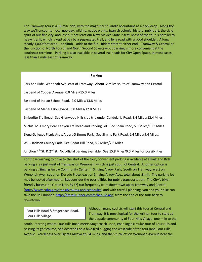
Parking
Park and Ride, Wenonah Ave. east of Tramway. About .2 miles south of Tramway and Central.
East end of Copper Avenue. 0.8 Miles/15.0 Miles.
East end of Indian School Road. 2.0 Miles/13.8 Miles.
East end of Menaul Boulevard. 3.0 Miles/12.8 Miles.
Embudito Trailhead. See Glenwood Hills side trip under Candelaria Road, 3.4 Miles/12.4 Miles.
Michial M. Emery Bear Canyon Trailhead and Parking Lot. See Spain Road, 5.5 Miles/10.3 Miles.
Elena Gallegos Picnic Area/Albert G Simms Park. See Simms Park Road, 6.4 Miles/9.4 Miles.
W. L. Jackson County Park. See Cedar Hill Road, 8.2 Miles/7.6 Miles
Junction 4th St. & 2nd St. No official parking available. See 15.8 Miles/0.0 Miles for possibilities.
Four Hills Road & Stagecoach Road,
Four Hills Village

top of the hill. Wenonah curves around to the north past a grocery store, arriving at Tramway and
Central.
Adjacent to the Four Hills residential area are two City Open Space areas worthy of side trips.
The first, Manzano Open Space can be accessed either from the end of Stagecoach Road or from La Cabra Drive, both within the Four Hills residential area and both with on-street parking allowed.
The second and more recently acquired land is the ’66 Open Space’. Development of this area is still in the planning stage; currently it can be accessed legally only from a gate on Highway 333, (Old U S 66) about .6 miles east of Tramway and Central. Jay Lee Evans, Open Space Division Planner, describes the land like this:
"The '66 Open Space' is a splendid and welcome addition to the City of Albuquerque's Major Public Open Space (MPOS) Network. The dramatic topography includes steep cliffs rising up from the perennially flowing Tijeras Arroyo stream, and is marked by lovely and stately mature cottonwood and willow stands. Besides the rich habitat value – the area is visited by deer, bear, bald eagle, and other native critters -- the 66 Open Space enjoys a rich historical tradition due to its proximity to 'The Mother Road', historic US Route 66. In the early 1960's, this was the site of 'Little Beaver Town', a replica of a frontier Wild West town, complete with cowboys, Indians, wild horses, buffalo, stagecoaches, gunfights in the street and bar-room brawls in the saloon. Twice a day."
As a very important note, City Open Space staff strongly discourages accessing this area by
walking or biking up Tijeras Arroyo from the informal parking area where Four Hills Road
crosses the Arroyo. This part of the Arroyo is private land and entering it constitutes trespass.
And remember, all City Open Space facilities are open to mountain bikes, but unauthorized
motor vehicles are strictly prohibited.
SE Corner, Central Avenue and Tramway Boulevard. In
addition to the Tramway Bike Trail, two other significant
bike routes start (or finish) here. Highway 333—old U S
66—heads west from here into Tijeras Canyon. Cyclists
may continue east on this road toward Edgewood, turn
north toward Sandia Crest and Santa Fe, or turn south toward Mountainair. Also, the I-40 bike path
runs northwest from here, following the interstate currently as far as Los Altos Park, and with breaks
on city streets, all the way to Unser Avenue on the West Side.
Long- time residents will recall an area near this intersection as the former site of the Western Skies
Motor Hotel. Built in 1959, demolished in 1988, the Hotel was an Albuquerque landmark, in its
heyday one of the most glamorous tourist spots in the city. Guests included Elvis Presley, Marilyn
Monroe, Kirk Douglas, Arnold Palmer, King Hussein of Jordan, and Hubert Humphrey. In December,
1962, President Kennedy stayed at Western Skies while on a visit to Sandia National Laboratory. But
from the beginning, the hotel was beset with financial and management problems which only
deepened, especially with the construction of Interstate 40 and the draining of tourists onto a new
artery lined with more modern facilities. Western Skies finally succumbed to back taxes, unpaid
bills, City code violations and a bleak location robbed of vital traffic.
0.0 Miles From Tramway & Central
15.8 Miles From Second & Fourth
Streets

In the southeast corner of Tramway and I-40 lies La Luz
de Amistad City Park with its sculpture, The Hand Of
Friendship. The first of many pieces of public art to be
found along the Tramway corridor, the sculpture was
dedicated in 1969, having been commissioned by a
private individual and later adopted by the City Arts
program. The Hand holds an eternal torch, encircled by
symbols of atomic energy and the Zia sunburst The
eternal flame of the torch has since been extinguished
due to cost concerns. Toward the north side of the park
sits a more recent sculpture. The park also has several
bicycle parking racks, themselves attractive objects plus a
few automobile parking spaces.
As you approach the I-40 overpass, you’ll notice Native
American design elements incorporated into the
horizontal members of the bridge. This is also part of the City
Arts program.
Formed on to the surfaces of the I-40 overpass
embankments, are enlarged castings of trilobites,
brachiopods and other extinct water-dwelling
invertebrates. The real 300 million year
old creatures were preserved as fossils in
limestone layers found in the nearby
Manzanita Mountains and also atop the Sandia
Crest. These lovely creations come to us courtesy of
the State Department of Transportation.
Passing under the I-40 overpass and starting up a
small grade, the Sandia Mountains come into clear
view. The approximately 15 mile long, 10,678 foot high range will remain an imposing presence
throughout this tour, visible to the east of Tramway Blvd. and directly behind (or ahead) of a cyclist
riding Tramway and Roy Roads. The mountains shape the surrounding terrain and weather,
influence development patterns, contribute to the City’s drinking water, and help form the very soil
on which our route passes. The range is a vast cultural, historic, scientific and recreational resource
for the entire state and beyond. For many residents in the metropolitan area, the mountains are
etched into their consciousness, a daily presence and a frame of reference for their lives in the City.
And of course it’s a source of many side trips for this tour. Contrary to what many think, the Sandias
are not part of the Rocky Mountains--that mountain system ends with the Sangre de Cristo range
near Santa Fe—but were formed tens of millions of years later. For a good introduction to the
geology, flora and fauna of the Sandias, see the Field Guide to the Sandia Mountains, edited by
Robert Julyan and Mary Stuever and published by the UNM Press.
The Hand Of Friendship
Trilobite
e

From I-40 to Lomas, the route follows the concrete-lined Tramway Diversion Channel. The Channel
is one of many examples of how government agencies have altered natural drainage patterns to
assure the safety of developed areas. In this case, rain water originating in the Sandias and flowing
westward down Copper, Lomas and smaller channels is diverted southward into Tijeras Arroyo,
protecting the homes just west of Tramway.
Copper Avenue. There is a pedestrian/bicycle overpass here, offering safe crossing
over Tramway. East of Tramway, Copper leads to a City Open Space trailhead for
hiking and mountain biking (approximately .7 miles). Car parking is available at the
trailhead.
A bike trail takes off to the east following a concrete lined channel, ending at
Embudo Hills City Park (about .6 miles).
Lomas Boulevard. The Lomas-Tramway Library sits in the southwest corner, offering
shade, water and of course books. Designed by architect Van H Gilbert, built in
1987, and renovated in 2010-11, the library has a large northeast-facing window
providing expansive
views of the
mountains. Skylights
and many other
windows further
contribute to the
open air feeling.
Public art abounds
here, with
sculptures inside
and out and with
more art hanging on
inside walls. Outside
are courtyards for
reading,
contemplation and
public events.
Started in 1978 and
patterned after similar programs around the country
as well as Europe, Albuquerque’s 1% for the Arts
program is funded by general obligation bonds, of
which 1% is allocated to public art. Later years saw the County and the State (which uses different
funding) adopt similar programs. Citizen committees are active in many of the critical aspects of the
Mile 0.8
Mile 15.0
Mile 1.2
Mile 14.6
Mile 1.4
Mile 14.4
“La Blessure,” Lomas-Tramway Library

City program. They work with City staff, neighborhood associations, community groups and others
to locate sites; identify the relevant physical, cultural, social or historical needs of the neighborhood
and various constituencies; determine the scope of requests for proposals and choose the artist.
1% For The Arts has created enormous City-wide benefit and enrichment. This is well summed up
by the late Gordon Church, City Public Arts Administrator from its founding in 1978 to 2004:
“At one level, public artworks in Albuquerque and Bernalillo County enhance our urban and
rural facilities, but at other levels works of art are used to convey community values, to
commemorate individuals, groups and events of our history, to punctuate economic
development efforts and to demonstrate new tools and techniques in the creation of visual
art-all to ensure that our environment is both functional and beautiful. They reflect the
essence of Albuquerque to ourselves and our visitors.”
Just north of Lomas in the planted strip between the bike path and the roadway, one sees the first
of many prairie dog communities found along Tramway. Known as Gunnison Prairie Dogs, they are
remnants of what was once a vast population native to Albuquerque and the Southwest. Along with
four other species, these small rodents (closely related to ground squirrels, not dogs) inhabited the
Great Plains from southern Canada to Mexico, occurring in enormous numbers which were
catastrophically reduced as the area was settled. Now several species are listed as Endangered and
Threatened.
In addition to their high-pitched
‘bark’ (hence the name dog), these
animals are known for their
sophisticated social behavior and
communication. Warning calls
announce predators, with different
calls for each kind of predator, and
when they’re gone an all clear is
sounded. ‘Kissing’, (actually the
rubbing of teeth), is another social
behavior which helps to determine
relatedness. Kissing behavior may
be followed by other friendly
actions such as mutual grooming.
Prairie dogs normally get all needed
water from the vegetation they eat.
The animals in these vegetated
strips are under the care of Prairie
Dog Pals (www.prairiedogpals.org.),
which provides supplemental feeding where necessary and transplants individuals when the
Prairie Dog Mother & Pup “Kissing”

population--lacking natural predators here--grows too large. Cold weather cyclists may see few of
these creatures since they hibernate in the winter.
A (painless) encounter with the New Mexico State Insect. The adjacent photo
shows a tarantula hawk wasp (genus Pepsis) seen along the Trail. This very large
(2”) wasp has an extremely painful sting but is relatively docile unless a female
encounters a tarantula at egg-laying time. Then a life and death struggle ensues
with a common outcome involving the wasp stinging the spider, paralyzing but not killing it. The
wasp drags the hapless arachnid to her nest where she lays an egg on it and buries it. Upon
hatching, the larval wasp burrows in, feeding on its supply of fresh meat, growing, and eventually
metamorphosing into an adult which bursts out of the now-empty spider skin. Adults have less
grisly feeding habits, drinking nectar from flowers. Among the very few predators daring to look at
these
venomous
insects as a
potential meal
is our own
iron-
stomached
state bird, the
roadrunner,
which also
dines on
scorpions and
rattlesnakes.
For the story of
how New
Mexico school
children helped
choose the
State Insect,
see http://www.statesymbolsusa.org/New_Mexico/Tarantula_hawk_wasp.html.
Indian School Road. East of Tramway, Indian School climbs steeply through the
foothills, ending at the parking lot for the Embudo Canyon Trailhead and City Open
Space (approximately 1.1 mile). Mountain bikes are welcome in City Open Space,
but are prohibited in National Forest Wilderness. Riding westward, Indian School along with
connecting streets and paths offers a continuous bike-friendly route to Broadway. There is a short
stretch of Indian School just west of Tramway not designated for bikes (approximately .3 miles), but
this stretch may be avoided by continuing less than one half mile north on Tramway to the Embudo
Recreational trail, turning west at Embudo and continuing to Indian School. Another possibility for
1.5 Miles
14.3 Miles
Miles
Miles
Tarantula Hawk Wasp
2.0 Miles
13.8 Miles
Sandia Pentstemen

westward travel involves riding down Indian School for
approximately .2 mile to its junction with Constitution.
Following Constitution as well as its bike-friendly
connecting routes takes you to UNM’s North Golf Course.
Signs along the Path identify the State Department of
Transportation as providing maintenance for the trail.
The trail is well lined with vegetation, much of it native.
Embudo Arroyo and Overpass.
Heading west along the Embudo
Arroyo, the Embudo Recreation Trail
provides access to Indian School Rd.
(see previous entry) and eventually turns into Paseo de las Montañas Trail, which runs westward to
Louisiana and I-40. To reach the trail, go over the wooden overpass and follow the path past a
small, pleasant City park (picnic tables and shade). Just past the park the trail crosses a bridge and
heads straight down the Arroyo. From Tramway looking eastward up the Arroyo you can see an
informal mountain bike trail which leads to a multi-use path, ending at an Open Space trailhead.
Embudo Arroyo itself follows a circuitous, mostly human-made route to the Rio Grande, running
west, northwest, and then southwest until it reaches I-40 where it flows between the east and west
bound lanes. It is eventually diverted out of I-40 and into the North Diversion Channel near Menaul
and University. See the separate guide to the NDC.
Menaul Boulevard. Eastward, Menaul climbs through the foothills development.
At .3 miles is Piedra Lisa City Park, an attractive facility with picnic tables and shade.
At the east end of the park, adjacent to City Open Space, note the huge and colorful
depiction of the Sandias painted on the concrete spillway for the flood control dam.
More public art sits at the park’s entrance. At .6 miles, Menaul ends at parking for City Open Space.
2.4 Miles
13.4 Miles
3.0 Miles
12.8 Miles
Sandia Pentstemen
“Morning Allegory”, Piedra Lisa Park

Piedra Lisa Arroyo -
Lexington Ave. and
Overpass. Crossing the
overpass provides access to several
westbound bike routes. One can follow
Lexington Ave. and several bike friendly
connecting routes to Claremont which runs to
a point just west of Carlisle. Alternatively, a
few steps north of the overpass, and also on
the west side is Piedra Lisa Arroyo and its
adjacent bike path. This path, along with
connecting bike routes turns southwest and
connects to the Embudo Recreation Trail and
Paseo de las Montañas (see mile 2.4, above).
Candelaria Road. Cyclists
wishing to ride a parallel
route somewhat closer to
the Open Space through Glenwood Hills may
follow the designated bike route east on
Candelaria, north on Camino de la Sierra,
continuing north on Glenwood Hills Dr. and
then west on Manitoba along with its
connecting streets. This route totals about 3
miles and includes many short steep hills. The
neighborhood is quiet with well kept homes.
(See side bar.)
Comanche Road. A wooden
overpass crosses Tramway.
Running west, the Comanche
Road bike lane meets Paseo del Nordeste bike
trail which then connects to the North
Diversion Channel bike path. This route also
crosses many north-south bike routes.
Eastward, Comanche dead ends at Open
Space; no car parking is allowed here.
Montgomery Blvd. Here
within the commercial
development, a cyclist can
3.2 Miles
12.6 Miles
3.4 Miles
12.4 Miles
Glenwood Hills Side Trip
.3 Miles/2.7 Miles. Climbing steadily,
Candelaria passes Casa Grande Linear Park, a
long narrow City recreation area following a
power line right of way and running from
Candelaria to a point just north of Comanche.
Parking spaces and a play ground are
adjacent to Candelaria, and a packed gravel
path runs its length. The power line, its right
of way, and the long term plan for a park
existed prior to the development of the
neighborhood and in the year 2000,
neighborhood meetings with the City led to
the facility’s eventual development. South of
Candelaria, the power line right of way is
owned by the Public Service Company of NM
and has a bicycle trail leading to the trailhead
at the end of Menaul Boulevard.
.5 Miles/2.5 Miles. Turn north on Camino de
la Sierra, and continue north on Glenwood
Hills Drive.
2.1 Miles/.9 Miles. Trailhead Road heads
east a short distance and a steep climb up to
the Embudito Trailhead and parking.
Approx. 2.2 Miles/.8 Miles. Turn west on
Manitoba. Manitoba intersects several
connecting streets before reaching Tramway.
(Cyclists riding from north to south will want
to reverse the following directions so that,
starting at Manitoba & Tramway, you will
turn east instead of west and north instead
of south).
From Manitoba, turn south on Calle de Luna.
Turn west on Manitoba.
Turn north on Larchmont.
Turn west on Manitoba.
3 Miles/0 Miles. Manitoba meets Tramway.
4.0 Miles
11.8 Miles
4.5 Miles
11.3 Miles

find many retail establishments providing refreshment.
Manitoba Drive. The parallel bike route running closer to the foothills enters from
the east. See Candelaria, 3.4 mi./12.4 mi..
Bridge over Arroyo del Oso (Bear Canyon). A dirt trail leads eastward up the
Arroyo, toward the foothills. The mountain bike trail connects to the Embudito
trail head (see side trip, above), the High Desert residential development with its
network of bike
lanes, and the
Elena Gallegos
Open Space area.
Westward from
Tramway, the
drainage has been
dammed and left
lightly developed,
enhancing both
flood control and
recreation. Arroyo
del Oso Park and
Arroyo del Oso
Golf Course are
examples of such
multi-use planning.
The Arroyo has a
series of bike paths
and routes on both sides which now run as far as the north side of I-25 and which long term will pass
over or under I-25 to connect with a short spur leading to the North Diversion Channel Bike Path.
Access to these routes is via the bike route on Spain, 5.5/10.3 miles. Land within this part of Bear
Canyon and on both sides of Tramway is City Open Space. The sculpture, “Osos Del Cañon” (see
photo), lies on the south bank of the Arroyo, a hundred feet or so west of Tramway Boulevard.
You’ll see it from the shoulder of the southbound lane. Informal walking trails lead closer.
Spain Road. Spain, an unsigned bike route, leads westward to bike friendly paths
following Bear Canyon (see City Map). To the east, Spain Road enters High Desert,
one of the area’s newer residential developments. Traveling east on Spain, you’ll
follow a strip of open space with interpretive signs explaining High Desert’s use of native vegetation
and surface runoff to keep it watered. At .6 miles, the junction with Imperata Road, you’ll find a
formal garden. Spain ends at .9 miles; turning south on High Desert for .1 mile takes you to the
Michial M. Emery Bear Canyon Trailhead and Parking Lot. As noted on the sign, the area is
5.0 Miles
10.8 Miles
5.1 Miles
10.7 Miles
Osos del Cañon
5.5 Miles
10.3 Miles

maintained by High Desert in co-operation with the Forest
Service, and is open 5:00 AM to 9:00 PM. A large sculpture
(photo) stands on High Desert land, just east of Tramway on the
north side of Spain. In the southeast corner is a smaller sculpture.
A small sign and map on the east side of the bike
path invites you to visit High Desert grounds and
art, including “… a variety of areas from a City
Park, formal gardens, streetscapes and natural open spaces.”
Academy Road. The road is named for nearby
Albuquerque Academy, one of the City’s most
prominent private schools and the former owner
of the Elena Gallegos Grant land. See the next entry, Mile 6.4.
Near the northeast corner of this intersection is another large
sculpture courtesy of High Desert.
Simms Park Road. This is the main entrance to the Elena Gallegos Picnic Area/Albert
G. Simms Park. Within the 640 acre park are trails for hiking or running, mountain
biking and horseback riding. The Pino Trail begins here and goes up through the
Sandia Mountain Wilderness to the Crest. Additional facilities include wheelchair accessible areas,
picnic shelters, interpretive signage, public art, and programs in environmental education—all for a
very modest entrance fee (bicyclists enter free). For a schedule of events see the Open Space
website, http://www.cabq.gov/openspace/education.html. The Park is an invaluable facility, the
pre-eminent unit of the Open Space system and its preservation is a landmark achievement for the
City and its citizens.
The story of Elena Gallegos, her land and how it changed hands is complex and somewhat mysterious--especially with regard to how Elena acquired the land. The full history is beyond the scope of this guide, but a summary from the State Historian can be found here: http://www.newmexicohistory.org/filedetails.php?fileID=24399#_edn2.
Elena, then a 32 year old widow, probably acquired the land in 1712. Upon her death, the land was divided among her heirs. They and subsequent heirs established individual home sites in the lower areas, but kept the west face of the Sandias as a ‘commons’ for such uses as grazing and logging. In 1893, the heirs filed a claim with the Court of Private Land Claims, seeking to uphold the original boundaries (approximately 70,000 acres, from the Rio Grande to the Crest) while the United States Government sought to have the area on the mountain removed, claiming the court had misinterpreted the language of the grant. The heirs prevailed, benefiting not only themselves but also future generations of Albuquerque residents who were able to purchase the area as a single large unit and preserve it.
Much of the land was lost to the State for back taxes in the 1920’s, and was bought first by a Gene Norment and later by Albert G Simms, a prominent businessman and U S Congressman. Simms, a principal supporter of the Albuquerque Academy, bequeathed to the school a substantial part of the grant when he died in 1964.
5.8 Miles
10.1 Miles
6.1 Miles
9.7 Miles
6.4 Miles
9.4 Miles
High Desert Sculpture

With open space acquisition already on the radar of the City and citizen groups, advocates became alarmed in 1980 when California developers offered to buy the land from the Academy. A well coordinated citizens’ effort, supported by then-Mayor Harry Kinney and the City Council led to Albuquerque residents voting a .25% increase to its gross receipts tax for the express purpose of buying the land. The selling price of 24.5 million dollars established by the Academy reflected altruism, civic mindedness, and good business sense given the alternatives. The purchase was ultimately successful and through a series of exchanges with the federal government, all of the grant land except for the 640 acres of Open Space was traded to the Forest Service. Federal land traded to the City was sold and used to establish a fund intended for the purchase and maintenance of Open Space.
Less than .1 mile north of Simms Park Rd., Pino Arroyo crosses Tramway, emptying into a basin
created by Pino Dam. The dam is one of several flood control facilities built to temporarily hold
water from a flash flood, releasing it slowly and safely. Below the dam, Pino Arroyo flows west into
Tanoan, a gated community. The Tanoan Golf Course which sits astride the Arroyo is part of an
easement granted by the Albuquerque Metropolitan Arroyo Flood Control Authority (AMAFCA- see
the tour for the North Diversion Channel), allowing the recreational facility to exist while
maintaining its ability to help control runoff. Land within the Arroyo and to the immediate east of
Tramway is City Open Space, with a mountain bike trail running toward the foothills.
San Rafael Avenue. San Rafael Avenue, along with connecting streets and bike paths
provides excellent access to points west. Go west on San Rafael, taking the first left
(south), on Tennyson St., then right (west) on Del Rey Ave. Del Rey, along with bike-
friendly connections runs all the way to Ellison and Journal Center.
Just south of San Bernardino is the crossing for South Domingo Baca Arroyo, wide
and shallow. Next to it just east of Tramway and alongside the Arroyo is a pretty,
small County park called Little Cloud Park, with a bike rack and public art.
Paseo del Norte bike path.
From here, one can ride
bike friendly routes to a
point just west of San Pedro and nearly to I-
25. After that, there are significant gaps
before one again reaches the path with its
junction at the North Diversion Channel.
Refer to the City Bike Map.
Cedar Hill Road. About ½
block east of Tramway lies
W. L. Jackson County Park, a
small, attractive facility with picnic tables, a
little shade, public art and several parking spaces.
6.9 Miles
8.9 Miles
7.4 Miles
8.4 Miles
7.6 Miles
8.2 Miles
8.2 Miles
7.6 Miles
South Of Cedar Hill Road

On rare occasions in this general area, cyclists may be treated to the sight of hang gliders coming in
for a landing at nearby Harrison Schmidt Hang Glider Park. The County park--originally called Big Sky
Hang Glider Park and then renamed after New Mexico’s former senator and astronaut--was created
to alleviate the problem of dwindling landing sites, as development gobbled up open space. In most
cases hang gliders landing here have launched from one of two sites near Sandia Crest. Hang glider
enthusiasts note that the current distance record is 438 miles, but for those not wishing to make an
extended trip, the County Park comes in handy. For more information about hang gliding in
Albuquerque, visit www.flysandia.org.
Junction Tramway Boulevard and Tramway Road. The elevation here is
approximately 6120’, the high point for the trip. From here cyclists will descend, (or
will have climbed) about 1,010’ to the river. Pausing before the drop, (or catching
one’s breath after the strenuous ascent), one is treated to panoramic views including the volcanoes
on the sweeping West Mesa, with another volcano, Mt. Taylor, beyond. To the northwest, the
southern tip of the Jemez Mountains is just visible and to the southwest, Ladrón Peak, 9,176 feet
high and about 60 miles away looms as a solitary presence rising above the desert floor.
To the east, Tramway Road rises steeply, terminating at the Sandia Peak Tramway. “The Tram,”
which climbs about 3,800 feet over its 2.7 mile course is one of the world’s longest and is a major
tourist attraction here in Albuquerque.
The west face of the Sandias in this general area was subject to litigation, negotiation and much
publicity for nearly 10 years, starting in the mid nineties. In 1994, the Sandia Pueblo filed a civil
lawsuit against the federal government, claiming ownership of about 9,900 acres of land on the
west face of the mountain all the way up to the crest. The claim was based on a 1748 grant to the
Pueblo by the King of Spain, a grant the Pueblo alleged was mistakenly altered in an 1859 United
States survey which omitted the acreage in question. With both sides having good reason to fear an
adverse court decision, the parties engaged in several years of negotiations, leading to a mutually
acceptable agreement which was finalized in 2000, and received formal recognition and support
through federal legislation, (Public Law H.J. Res2-2), a few years later. Under the terms of the
agreement, the Pueblo was assured access to the area for cultural and religious purposes, and was
also guaranteed a voice in any possible future changes in the area’s management. The federal
government retained ownership of the land, with the understanding it would be managed according
to its existing uses. Private property owners were assured of the permanence of their ownership as
well as access to their land.
Forest Road 333. Popular with cyclists wishing to test their climbing ability, the
road ascends through the foothills to Juan Tabo Picnic Ground. For hikers, branches
of the road lead to the La Luz and the Piedra Lisa trailheads, ending at Sandia Crest
and near Placitas, respectively. From this point, gazing to the immediate south and for a
considerable distance to the north, one is struck by the wide open spaces which are in stark contrast
to the nearby development of Albuquerque and Bernalillo County. This open space reflects current
policies of Sandia Pueblo, owner of the land. Looking directly across the road to the south, one sees
8.7 Miles
7.1 Miles
9.4 Miles
6.4 Miles

very sturdy fencing running east-west, part of Sandia Pueblo’s buffalo enclosure. The Pueblo
maintains a herd of about 45 animals as part of their cultural tradition and also as a tourist
attraction. Long time City residents who traveled on Rio Grande Blvd. will recall the small herd of
bison near the big curve (still referred to as the “Buffalo Curve”) in the road. Many individuals in the
Pueblo’s current herd are descendents of those animals, with others brought in from neighboring
states to improve genetic diversity. As a word of warning, these are wild animals, capable of
inflicting serious injury and should not be approached.
Rainbow Road. Sandia Resort and Casino. The striking building, visible for miles
around, incorporates many traditional pueblo architectural and design elements
but on a grand scale, both inside and out. Inside the hotel lobby are many pieces of
art depicting pueblo culture and history. Just to the south of the casino entrance is a gas station and
Indian arts store, also operated by the Pueblo. Indian gaming, since taking root in NM and
elsewhere has undoubtedly created economic benefits for many Native Americans and arguably, for
the larger state and local economies. Numerous studies have been done to assess overall costs vs.
benefits, but big conclusions remain elusive, as the discussion continues.
Under I-25. The Claret-cup cactus and other native plants have been planted by
the casino-resort.
Traffic circle. From this
junction NM 313 heads
north to Shady Lakes, a
commercial, heavily-stocked fishing pons
with a beautiful collection of water lilies,
3 mi. to Sandia Pueblo itself, and 7 miles
to Bernalillo. A very short distance up
NM 313 is the Sandia Pueblo Station for
the New Mexico Rail Runner, whose sleek
trains run from Santa Fe to Belen, with many stops in between. Those not wishing to ride a
complete a loop as part of this tour might consider using the Rail Runner—which carries bicycles—to
help close the circle, (http://nmrailrunner.com/schedule.asp). The Rail Runner’s downtown
Albuquerque station is part of the City’s Alvarado Transportation Center, an important hub for the
City’s bicycle-friendly buses, (http://www.cabq.gov/transit/routes-and-schedules).
Bridge over the North Diversion Channel. This is the outlet for the NDC into the
Rio Grande. The sediment brought down through the channel as well as water
backed up from the river creates a relatively lush environment supporting many
plants, birds, and other wildlife. It is not possible to bicycle south on the NDC from here; if you wish
to do that, head south on Second Street to Paseo del Norte, where a bike rail will take you up
intersect with the NDC.
13.2 Miles
2.6 Miles
13.7 Miles
2.1 Miles
15.2 Miles
0.6 Miles
15.5 Miles
0.3 Miles
The Claret Cup Cactus

Junction of Second and Fourth Streets. This is the end of the trip. A sign on
Second Street says “Leaving Sandia Pueblo Reservation”. The elevation here is
approximately 5010 feet.
Parking at this end of the route is problematic. One possibility is the Rail Runner station (see mile
15.1). Another unofficial but probably safe place is the parking lot at Bernalillo County’s Raymond
G. Sanchez Community Center, 9800 4th NW, about 1.2 miles south of here.
Thanks to these kind people for their assistance:
Linda Biesanz, Yvonne Boudreaux, Jay Lee Brendon, Adrienne Candelaria, Doug Collister, Jay Evans,
Charlie Glantz, Paul Grosvenor, William S Hutchinson, Dr. Barry Kues, Carmen Marrone, Brian
McKeever, Cid Morgan, Roland Pentilla, Brendan S Picker, Matt Schmader, Ed Urbanski, Lomas
Library staff, Research staff at Main Library, especially David Schneider.
Photo Credits
Hand of Friendship, La Blessure, Morning Allegory: City Of Albuquerque
Kissing Prairie Dogs: Ed Urbanski
Claret Cup Cactus: www.southwestcoloradowildflowers.com
All Others: The Authors
15.8 Miles
0.0 Miles