the system: software/electronics/control/navigation steve mcphail miles pebody, james perrett l the...
TRANSCRIPT

The System:The System:Software/Electronics/Control/NavigationSoftware/Electronics/Control/Navigation
Steve McPhailSteve McPhail Miles Pebody, James Perrett Miles Pebody, James Perrett
The system is Physically Modular: 15 nodes (sub-systems)The system is Physically Modular: 15 nodes (sub-systems) Truly Distributed: No sub-system is overly complicated Truly Distributed: No sub-system is overly complicated Uses a small subset of simple hardware (2 types mostly) Uses a small subset of simple hardware (2 types mostly) The hardware is easy to programme The hardware is easy to programme The Interfaces / Data flows are well definedThe Interfaces / Data flows are well defined System Data logging is straightforwardSystem Data logging is straightforward >>>>

Autosub Distributed System ArchitectureAutosub Distributed System Architecture
EMERGENCY ABORT
MISSION CONTROL
DEPTH CONTROLPOSITION CONTROL
MOTOR + SPEED CONTROL
ROUTER / RADIO MODEM
DATA LOGGER
ACOUSTIC COMS ORBCOMM SAT. COMS
ADCP
ATTITUDE SENSOR
GPS NAVIGATION
FWD ECHO SOUNDER
DEPTH SENSOR(S)
LINE DEPLOY SYSTEM
LonWorks Network
POWER SYSTEM 100V
24V
48V
Distributed Power
Harness
END
ARGOS
ARGOS
LIGHTS
HF TRANSPONDER
LF TRANSPONDER
>>

EEmergency mergency AAbort bort SSystemystem
EAS Abort System Drops the Ballast weight and stops the EAS Abort System Drops the Ballast weight and stops the motor IFF:motor IFF:• Vehicle has dived too deepVehicle has dived too deep (max depth)(max depth)• Mission Has been continuing for too longMission Has been continuing for too long (mission timeout)(mission timeout)• Vehicle has been submerged for too long Vehicle has been submerged for too long (dive timeout)(dive timeout) • Leak of one of the 6 main pressure cases Leak of one of the 6 main pressure cases • Battery over temperatureBattery over temperature• Communications Failure with pressure sensors or Mission Control Communications Failure with pressure sensors or Mission Control
nodes;nodes;• Command from Acoustic Command system (either HF or LF)Command from Acoustic Command system (either HF or LF)• Failure of power (as Solenoid is held on with Electromagnet).Failure of power (as Solenoid is held on with Electromagnet).
EAS also periodically and actively enables propulsion EAS also periodically and actively enables propulsion motor so that system fails safe (motor is disabled) motor so that system fails safe (motor is disabled) >>

MISSION CONTROLMISSION CONTROL
MissionControlNode
Mission Script (Via Radio)
START, STOP, ABORT
TIMEOUT
GOT GPS FIX
REACHED XY POS.
REACHED DEPTH
DIVED
SURFACED
POSITION Demands
DEPTH Demands
MTR POWER Demands
Events trigger execution of next line in Mission Script : - demands are sent out to Control nodes

Example of 1 line of Mission Script.Example of 1 line of Mission Script.
WHEN(GotGPSfix)WHEN(GotGPSfix) // When GPS fix acquired// When GPS fix acquired ……… ………
MotorPower(400), MotorPower(400), // Set Motor Power to 400 Watts.// Set Motor Power to 400 Watts.
TimeOut(5000),TimeOut(5000), // Set timeout of 5000 seconds.// Set timeout of 5000 seconds.
Depth(10),Depth(10), // Dive to 10 metres.// Dive to 10 metres.
TrackP(N:56:27.586, W:5:29.477); // Follow to end of trackTrackP(N:56:27.586, W:5:29.477); // Follow to end of track
// Next line, when reached end of the track ……// Next line, when reached end of the track ……
WHEN(GotPosition)WHEN(GotPosition) // When Got there (OR timeout) // When Got there (OR timeout) >> ……… ………
// When satisfactory GPS fix has been acquired dive and track follow: // Set timeout to 5000 seconds.

Autosub Systems: Autosub Systems: Propulsion and Propulsion and ActuatorsActuators
Direct drive DC motor.Direct drive DC motor.No gear box or shaft No gear box or shaft sealseal~ 70% efficiency~ 70% efficiency
Specially Specially designed designed propeller. 250 N propeller. 250 N thrust ~ 70% thrust ~ 70% efficiencyefficiency
Actuators Actuators pressure pressure balanced: balanced: no shaft sealno shaft seal

Position (Rudder), Depth (Stern Position (Rudder), Depth (Stern Plane),Plane), Speed (Motor) Control Nodes. Speed (Motor) Control Nodes.
Motor Control
Position Control
Depth Control
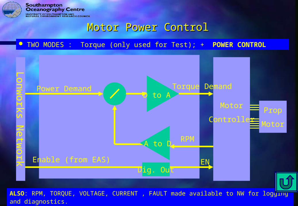
Motor Power ControlMotor Power Control TWO MODES : Torque (only used for Test); + POWER CONTROL
ALSO: RPM, TORQUE, VOLTAGE, CURRENT , FAULT made available to NW for logging and diagnostics.
Motor
ControllerProp
Motor
Lon
works N
etw
ork
D to A
RPM
Torque DemandPower Demand
Enable (from EAS)
A to D
Dig. OutEN

Position ControlPosition Control CONTROL MODES:CONTROL MODES:
• RUDDERRUDDER (Only Useful during set-up and test)(Only Useful during set-up and test)
• HEADINGHEADING (Sometimes useful, And needed for compass calibration)(Sometimes useful, And needed for compass calibration)
• POSITIONPOSITION (Line Of Sight).. Head directly towards Way Point.(Line Of Sight).. Head directly towards Way Point.
• TRACK FOLLOW :TRACK FOLLOW :
(Follow Straight line track between WP(Follow Straight line track between WPnn, WP, WPn+1n+1… The most useful..) … The most useful..)
>>>>

Position Cascade ControlPosition Cascade Control
Position
Heading
Lon
works N
etw
ork
ALSO: Rudder Position, Range to Go, Fault, and Intermediates made available to NW for logging & Diagnostics.
|L|
|Pp|
|Ph, Dh
Scale+Offset|
Track Demand
Track Follower
PositionController
HeadingController
Position Demand
Heading Demand
Rudder Demand ADC
Servo
Motor
ControlRudder
Motor
Pot
48 V

6
4
zDi
zi
i
deg
i
deg
220150 horizontali
150 160 170 180 190 200 210 2204
2
0
2
4
6
DepthDemand (m)Depth (m)Pitch (degrees)Stern-plane (degrees)
HORIZONTAL DISTANCE (m)
Time Domain Simulation (MathCad)Time Domain Simulation (MathCad)Response to step depth demand change of 5 mResponse to step depth demand change of 5 m

Depth and Altitude ControlDepth and Altitude Control CONTROL MODES:CONTROL MODES:
• SternPlaneSternPlane
Useful during diving and setup/testUseful during diving and setup/test• DepthDepth
Where Constant Depth Required. Where Constant Depth Required. NB safety limits overideNB safety limits overide• AltitudeAltitude
Where Constant Altitude required. Where Constant Altitude required. NB safety limits overideNB safety limits overide
Feedback via ADCP Altitude AND Fwd echo sounderFeedback via ADCP Altitude AND Fwd echo sounder
SAFETY LIMITS:SAFETY LIMITS: • MaxMaximum Depthimum Depth• MinMinimum Altitudeimum Altitude• MaxMaximum Pitch (up) eg. +60 degrees.imum Pitch (up) eg. +60 degrees.
• MinMinimum Pitch (down) eg. -15 degrees imum Pitch (down) eg. -15 degrees
>>>>

Depth and Altitude Cascade ControlDepth and Altitude Cascade Control
Depth
Pitch
Lon
works N
etw
ork
ALSO: SternPlane Position. Fault and Intermediates Output to Netwrok for Logging and Diagnostics
Pp, Dp
Scale+Offset
AltitudeDemand
Altitude && Depth Controller
PitchController
Pitch Demand
SternPlane
Demand ADC
Servo
Motor
ControlStern-PlaneMotor
Potentio-meter
48 V
Pz, Iz, Dz Max Pitch, Min Pitch,Max Depth,Min Altitude
Altitude (ADCP)
FWD Range

Echo Sounder and ADCPEcho Sounder and ADCP
Simrad Mesotech. 200kHzEffective range 180 m
(Should be 300 m)

Autosub NavigationAutosub Navigation
(Via Radio or Acoustic Modem)
DGPS receiver(IDAR Capable)
Navigation processor
DopplerVelocity
Log
Attitude sensor
heading
salinity[temperature]
depth
Latitude, Longitude
Depth sensor
Vnorth Veast
position fix
(For speed of sound calculation)
GPS Antenna position fix
AcousticTransponder
USBL Tracking System
INS

Inertial Navigation System (INS) for Autosub Inertial Navigation System (INS) for Autosub
INS INS unaidedunaided Position estimate performance is Position estimate performance is ultimately limited by ultimately limited by Bias StabilityBias Stability of the Gyros. of the Gyros.
AffordableAffordable Gyros for AUVs (FOG or RLG) have: Gyros for AUVs (FOG or RLG) have:
Gyro Bias StabilityGyro Bias Stability 0.005 degrees/ 0.005 degrees/ hour.hour.
INS Position DriftINS Position Drift 60 n.m. x Gyro Bias Stability 60 n.m. x Gyro Bias Stability
0.3 knt. (Is 8 % of 4 0.3 knt. (Is 8 % of 4 knt.)knt.)
Practical SystemPractical System mustmust use aiding by Doppler Velocity. use aiding by Doppler Velocity. In this mode INS effectively is giving high accuracy In this mode INS effectively is giving high accuracy
heading.heading. 0.1% of distance travelled is achievable. 0.1% of distance travelled is achievable.
>>>>

Seatex MRU6 Attitude SensorSeatex MRU6 Attitude Sensor
Measures Roll, Pitch and Heading.Measures Roll, Pitch and Heading. Heading based on Tri-axis flux gate compass.Heading based on Tri-axis flux gate compass.
Crucial to dead-reckoning navigation (ADCP) + heading control. Crucial to dead-reckoning navigation (ADCP) + heading control. Problems with any such compass are Problems with any such compass are
A) Establishing compass deviation in local area (MagneticNorth - A) Establishing compass deviation in local area (MagneticNorth - TrueNorth )TrueNorth )
B) Magnetic materials on Autosub causing hard iron effects. B) Magnetic materials on Autosub causing hard iron effects. (Heading error which is sinusoidal Vs true heading, can be (Heading error which is sinusoidal Vs true heading, can be several degrees error)several degrees error)
Both are dealt with by calibration mission taking about 30 minutes. Both are dealt with by calibration mission taking about 30 minutes.
Vehicle runs N,E,S,W submerged (15 minutes)Vehicle runs N,E,S,W submerged (15 minutes)
Surfaces gets GPS fix, dives and runs in constant direction for Surfaces gets GPS fix, dives and runs in constant direction for 15 minutes, then surfaces and gets GPS fix.15 minutes, then surfaces and gets GPS fix.
This reduces errors to +/-0.5 degrees. This reduces errors to +/-0.5 degrees. Such a calibration mission needed where significant movement of Such a calibration mission needed where significant movement of
ferrous objects near Compass and/or large change in geographical ferrous objects near Compass and/or large change in geographical
location. location. >>>>

LEO Satellites. Email type of service. (Also Doppler LEO Satellites. Email type of service. (Also Doppler position available)position available)
Messages sent immediately on surfacing. 90% availabilityMessages sent immediately on surfacing. 90% availability
Basic Parameters Sent:Basic Parameters Sent:• (position, GPS fix, time since fix, battery state, errors, (position, GPS fix, time since fix, battery state, errors,
leaks, temperatures, mission line…)leaks, temperatures, mission line…) Messages relayed to:Messages relayed to:
• Mobile phone SMS serviceMobile phone SMS service• 2nd Orbcomm transceiver.2nd Orbcomm transceiver.
ARGOS position messages also forwarded to the above.ARGOS position messages also forwarded to the above. 2 way coms is an option (not implemented in Autosub). 2 way coms is an option (not implemented in Autosub).
>>>>
Orbcomm Telemetry: Autosub to base.Orbcomm Telemetry: Autosub to base.

Forward Collision AvoidanceForward Collision Avoidance
!The control algorithm for Forward Collision Avoidance !The control algorithm for Forward Collision Avoidance has proved to be not as effective as hoped (As proved has proved to be not as effective as hoped (As proved by collision with cliff in Sicilian channel)!by collision with cliff in Sicilian channel)!
We will be working on the problem, improving We will be working on the problem, improving algorithm by end of 2001. algorithm by end of 2001.
Upgrade will be free to you. Upgrade will be free to you. >>>>

Digiquartz Pressure SensorsDigiquartz Pressure Sensors
Diquartz 4000m rated Vibratory quartz pressure sensors. Diquartz 4000m rated Vibratory quartz pressure sensors. Rated Accuracy 0.01% Fs (40 cm equivalent). Resolution Rated Accuracy 0.01% Fs (40 cm equivalent). Resolution is 3cm. is 3cm.
In practice zero offset is most important for our use, as In practice zero offset is most important for our use, as AUV control determines whether on-surface or dived AUV control determines whether on-surface or dived using pressure only. using pressure only.
Sensor has RS232 output. One of our standard interface Sensor has RS232 output. One of our standard interface boards connect its data to the network. Sampled at 2 Hz. boards connect its data to the network. Sampled at 2 Hz.
2nd sensor added for EAS, as we found that there was a 2nd sensor added for EAS, as we found that there was a possible single point failure to abort on overdepth if one possible single point failure to abort on overdepth if one
sensor failed (and read low).sensor failed (and read low). We have found that performance is good & to We have found that performance is good & to
specificationspecification>>>>

RDI ADCP 300 kHz WHRDI ADCP 300 kHz WH Measures Velocities and Altitudes. Measures Velocities and Altitudes. Will Will BBottom ottom TTrack to 200 m altitude (necessary for good rack to 200 m altitude (necessary for good
navigation), beyond that relies on navigation), beyond that relies on VVelocity elocity TThrough hrough WWater. (System can fill in short gaps in bottom track, by ater. (System can fill in short gaps in bottom track, by calculating local current when BT available, then adding calculating local current when BT available, then adding this to VTW)this to VTW)
Is a current profiler, (but you are probably not interested Is a current profiler, (but you are probably not interested in that) You will set the number of profile bins to a in that) You will set the number of profile bins to a minimum (3), so that you can ping at maximum rate minimum (3), so that you can ping at maximum rate (about 1.5 seconds). (about 1.5 seconds).
Frame of reference rotation done in ADCP, using Heading Frame of reference rotation done in ADCP, using Heading sensor input. Hence important output is Vnorth, Veast.sensor input. Hence important output is Vnorth, Veast.
! Given time I would look at possibilities of having it fire ! Given time I would look at possibilities of having it fire through an acoustic window, as having it poking out the through an acoustic window, as having it poking out the bottom gives increase in drag, and it is vulnerable. bottom gives increase in drag, and it is vulnerable.
>>>>

Power SystemPower System
Integrates + fuses power from 4 battery tubes.Integrates + fuses power from 4 battery tubes. Separate “Fuse Pot”, externally plugged in to pressure Separate “Fuse Pot”, externally plugged in to pressure
case, for convenience is designed to blow before internal case, for convenience is designed to blow before internal fuses. fuses.
Provides 24 volt (450 Watt), 48 volt (300 Watt) and raw Provides 24 volt (450 Watt), 48 volt (300 Watt) and raw battery volts (15 Amp max from 120 to 60 volt).battery volts (15 Amp max from 120 to 60 volt).
Measures battery ,and converter currents and voltages. Measures battery ,and converter currents and voltages. Also measures temperatures in the battery tubes, and Also measures temperatures in the battery tubes, and
can detect a leak in any tube. can detect a leak in any tube. >>>>

Line Deployment SystemLine Deployment System(Jack in the box)(Jack in the box)
Small float attached to string held on with Small float attached to string held on with electromagnet; released by radio command at end of electromagnet; released by radio command at end of mission. Spring helps release. mission. Spring helps release.
Float is grappled for, recovered and string pulled in.Float is grappled for, recovered and string pulled in. String attached to thicker recovery lines (for and aft) String attached to thicker recovery lines (for and aft)
which are attached to recovery winches, and then which are attached to recovery winches, and then vehicle recovered.vehicle recovered.
Electromagnet is same design as EAS abort weight Electromagnet is same design as EAS abort weight solenoid.solenoid.
Control hardware is a “standard interface pot” (which is Control hardware is a “standard interface pot” (which is shared with the LF acoustics interface). shared with the LF acoustics interface). >>>>

Standard Interface POTStandard Interface POT
Power and LonWorks
15, 24, 48 volt isolated
RS232
AUTOSUB SYSTEM
Power isolate/protect.
LonWorks interface
300 mm
115 mm
Was useful in coping with rapid changes in science sensorsOne is used for LF Acoustics and Jack-in Box (combined)
24 volt to solenoid
To SeaPam

Acoustic CommunicationsAcoustic Communications Since 1997 have used simple Since 1997 have used simple AApplied pplied AAcoustic Engineering HF coustic Engineering HF
(around 30 kHz) system giving:(around 30 kHz) system giving: Pulse delay telemetry (altitude, depth, heading);Pulse delay telemetry (altitude, depth, heading);
Command to AUV (GO, STOP, ABORT, SURFACE, CENTRE)Command to AUV (GO, STOP, ABORT, SURFACE, CENTRE)
Tracking Using ORE LXT system, with on screen plotting (IPS)Tracking Using ORE LXT system, with on screen plotting (IPS)
! System has worked well. Only notable problem is on Command ! System has worked well. Only notable problem is on Command giving false command (notably tends to abort (drops weight when giving false command (notably tends to abort (drops weight when we want to stop)we want to stop)
Also tracking range ( 2 km), is not adequate for deep diving missionsAlso tracking range ( 2 km), is not adequate for deep diving missions New all digital LF (~12 kHz) ordered in January 1999 from AAE.New all digital LF (~12 kHz) ordered in January 1999 from AAE.
Two way digital coms at ~100 baud to 5km, as well as transponder Two way digital coms at ~100 baud to 5km, as well as transponder mode, and pulse delay telemetrymode, and pulse delay telemetry..
OurOur Vehicle And Top End software for command, telemetry, acoustic Vehicle And Top End software for command, telemetry, acoustic navigation fix is done but:navigation fix is done but:
! There have been many problems with AAE ‘SeaPam / DeckPam’. ! There have been many problems with AAE ‘SeaPam / DeckPam’. Digital coms never really worked beyond 500 m.Digital coms never really worked beyond 500 m. Pulse delay Pulse delay telemetry is little better. However they say that their upgrade using telemetry is little better. However they say that their upgrade using DSP technology is going well. (April 2001)… DSP technology is going well. (April 2001)…
>>>>

Router / Radio ModemRouter / Radio Modem
Allows remote Allows remote TransparentTransparent access to the LonWorks Network. access to the LonWorks Network. Only 4800 baud link; but adequate for mission uploads, and Only 4800 baud link; but adequate for mission uploads, and
browsing the vehicle network sub-systems, and for ship utilities browsing the vehicle network sub-systems, and for ship utilities (starting / stopping / checking systems)(starting / stopping / checking systems)
Uses Multitone transciever ~ 450 MHz. Range about 1km at best. Uses Multitone transciever ~ 450 MHz. Range about 1km at best. Router is our own HW based on standard Echelon module. Needed Router is our own HW based on standard Echelon module. Needed
to avoid congestion of low bit rate radio modem. to avoid congestion of low bit rate radio modem. Aerial of own design (made by PDM Ltd), identical to the ARGOS Aerial of own design (made by PDM Ltd), identical to the ARGOS
antennae.antennae. Identical hardware at ship end completes link. Identical hardware at ship end completes link.
>>>>

Data Logger and Radio EthernetData Logger and Radio Ethernet PC104 486 DOS based data loggerPC104 486 DOS based data logger Selectively Timestamps and records messages off the LonWorks Selectively Timestamps and records messages off the LonWorks
NetworkNetwork 10 Mbit/s Radio Ethernet allows data download remotely (up to 500 10 Mbit/s Radio Ethernet allows data download remotely (up to 500
m range)m range) Currently 2 Gbyte hard-disk. More requires 32bit FAT (not tried yet).Currently 2 Gbyte hard-disk. More requires 32bit FAT (not tried yet). ! Could be modified to log Ethernet data as well ? ! Could be modified to log Ethernet data as well ?
>>>>

Main 19 way Harness 2/1/2000.
PIN NAMEJ1--1 LONWORKS Twisted pair 1a (GO)J1-2 LONWORKS Twisted pair 1b (GO)J1-3 LONWORKS Twisted pair 2a (RETURN)J1-4 LONWORKS Twisted pair 2b (RETURN)J1-5J1-6J1-7J1-8J1-9 ScreenJ1-10 24volt_0J1-11 24volt_+J1-12 24volt_0J1-13 24volt_+J1-14 48volt_0J1-15 48volt_+J1-16J1-17J1-18J1-19
Go and Return on Twisted pairs so that External Go and Return on Twisted pairs so that External (wet) Harnesses can be daisy chained together, (wet) Harnesses can be daisy chained together, giving flexibility on number of nodes (sub-giving flexibility on number of nodes (sub-systems) in system. systems) in system.
Each Harness has 4 male and one female Each Harness has 4 male and one female connector. connector.
>>>>

RelocationRelocation
Satellite: 2 independent ARGOS beaconsSatellite: 2 independent ARGOS beacons. . (2 month duration). (2 month duration).
• On surface ARGOS Transmits every 120 seconds for approximately On surface ARGOS Transmits every 120 seconds for approximately 1 second. Satellite locates mobile by Doppler shift.1 second. Satellite locates mobile by Doppler shift.
• Position Fixes available by Telnet/Email/Fax/ (by subscription).Position Fixes available by Telnet/Email/Fax/ (by subscription).• Passes are approximately every hour at this latitude.(Better higher Passes are approximately every hour at this latitude.(Better higher
latitude)latitude)• We also use a direction finder (GONIO) to locate .... Useful.We also use a direction finder (GONIO) to locate .... Useful.• ! Hardware transmitters we use are old ... possibly obsolete, (but ! Hardware transmitters we use are old ... possibly obsolete, (but
plenty of alternatives)plenty of alternatives)• Orbcomm also useful for relocationOrbcomm also useful for relocation
Acoustic Tracking. Have ~30 kHz, and ~12 kHz stand alone Acoustic Tracking. Have ~30 kHz, and ~12 kHz stand alone transponders as well as telemetry transponders (total of four). Used for transponders as well as telemetry transponders (total of four). Used for tracking underwater, up to 6km (LF), 2km (HF). Use ORE LXT and tracking underwater, up to 6km (LF), 2km (HF). Use ORE LXT and Trackpoint II systems.Trackpoint II systems.
Flashing lights. (Makes dark location easier than day) Flashing lights. (Makes dark location easier than day)
>>>>


