the swanzey fish dam: a large, precontact native
TRANSCRIPT
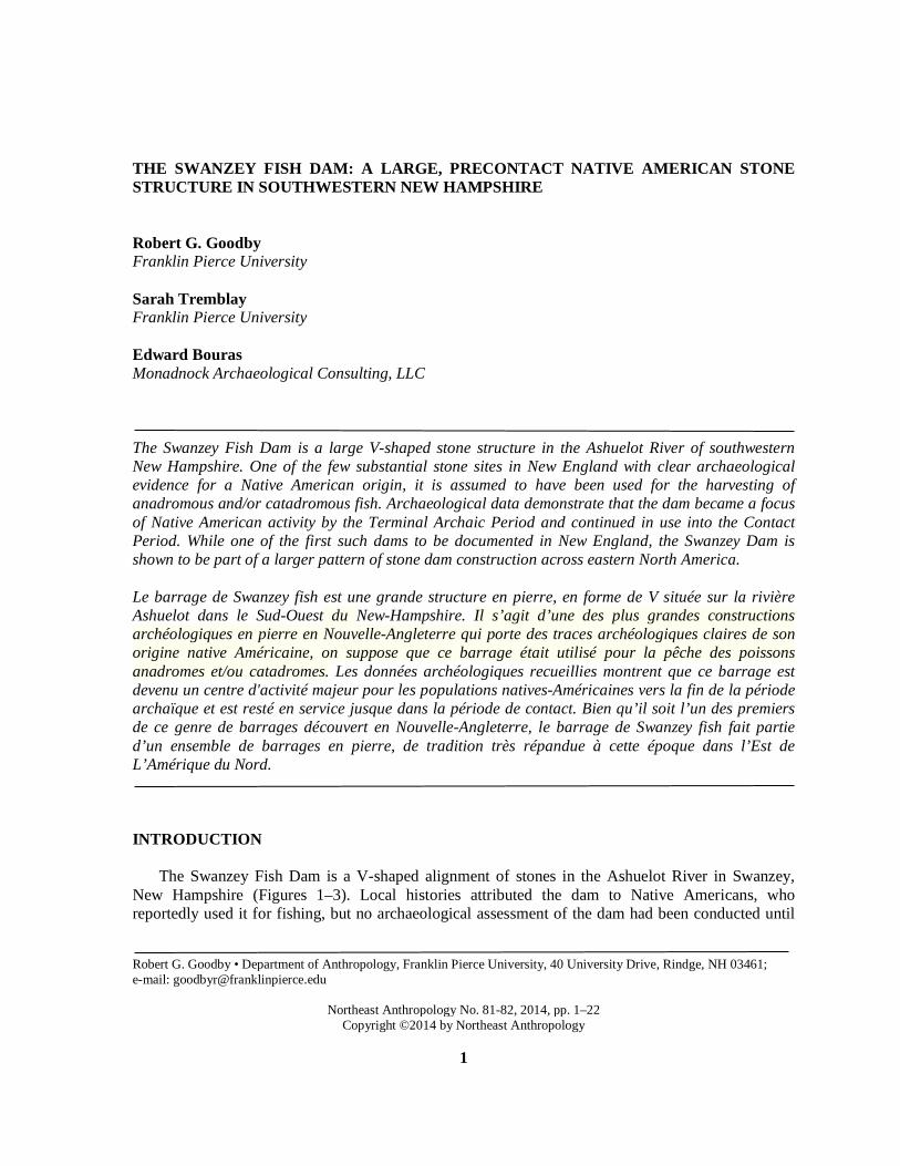
THE SWANZEY FISH DAM: A LARGE, PRECONTACT NATIVE AMERICAN STONE STRUCTURE IN SOUTHWESTERN NEW HAMPSHIRE Robert G. Goodby Franklin Pierce University Sarah Tremblay Franklin Pierce University Edward Bouras Monadnock Archaeological Consulting, LLC The Swanzey Fish Dam is a large V-shaped stone structure in the Ashuelot River of southwestern New Hampshire. One of the few substantial stone sites in New England with clear archaeological evidence for a Native American origin, it is assumed to have been used for the harvesting of anadromous and/or catadromous fish. Archaeological data demonstrate that the dam became a focus of Native American activity by the Terminal Archaic Period and continued in use into the Contact Period. While one of the first such dams to be documented in New England, the Swanzey Dam is shown to be part of a larger pattern of stone dam construction across eastern North America. Le barrage de Swanzey fish est une grande structure en pierre, en forme de V située sur la rivière Ashuelot dans le Sud-Ouest du New-Hampshire. Il s’agit d’une des plus grandes constructions archéologiques en pierre en Nouvelle-Angleterre qui porte des traces archéologiques claires de son origine native Américaine, on suppose que ce barrage était utilisé pour la pêche des poissons anadromes et/ou catadromes. Les données archéologiques recueillies montrent que ce barrage est devenu un centre d'activité majeur pour les populations natives-Américaines vers la fin de la période archaïque et est resté en service jusque dans la période de contact. Bien qu’il soit l’un des premiers de ce genre de barrages découvert en Nouvelle-Angleterre, le barrage de Swanzey fish fait partie d’un ensemble de barrages en pierre, de tradition très répandue à cette époque dans l’Est de L’Amérique du Nord. INTRODUCTION
The Swanzey Fish Dam is a V-shaped alignment of stones in the Ashuelot River in Swanzey,
New Hampshire (Figures 1–3). Local histories attributed the dam to Native Americans, who reportedly used it for fishing, but no archaeological assessment of the dam had been conducted until
Robert G. Goodby • Department of Anthropology, Franklin Pierce University, 40 University Drive, Rindge, NH 03461; e-mail: [email protected]
Northeast Anthropology No. 81-82, 2014, pp. 1–22
Copyright ©2014 by Northeast Anthropology
1

2 Northeast Anthropology No. 81/82, 2014
Figure 1. Swanzey Fish Dam location.

Goodby et al. The Swanzey Fish Dam 3
Figure 2. Excavation plan and feature locations.

4 Northeast Anthropology No. 81/82, 2014
Figure 3. Map of the Swanzey Fish Dam.
2002, when Franklin Pierce University began a decade of research at the site. Diagnostic artifacts and radiocarbon dates from this study showed the dam was built by Native Americans during the early Terminal Archaic Period, c. 3800 B.P., and continued in use until the Contact Period (Goodby 2006; Goodby et al. 2004; Ogden 2004). The dam is one of the only substantial stone structures attributable to precontact Native Americans in New England, and is part of a widespread pattern of similar dams noted across much of the rest of eastern North America.
ENVIRONMENTAL SETTING
The Swanzey Fish Dam is located in the Ashuelot River in Swanzey, New Hampshire, just north
of its confluence with a small, seasonal stream that drains into the Ashuelot from the northwest. The Ashuelot River, a tributary of the Connecticut River, was a focus of Native American occupation in the Monadnock Region of southwestern New Hampshire. The decision to build the dam at this specific location was likely influenced by a number of factors: the unusually rocky bed of the

Goodby et al. The Swanzey Fish Dam 5
Ashuelot at this spot that would have provided ready access to stones for the construction of the dam; the relatively shallow and fast-flowing water; and, on the west bank, the low, level outwash terrace underlain by excessively drained Caeser Loamy Sand that is only a meter or less above the level of the river and would have provided a suitable work area and access point to the dam (Figure 4). The east bank (Figure 5), in contrast, has a steep slope rising to a level outwash terrace of excessively drained Windsor Loamy fine sand between 8 m and 10 m above the level of the river, which would have made access to the river more difficult, with relatively less room to work at the water’s edge. Other locations in the vicinity are less suitable: to the north, the terrain rises gradually, creating an increasingly high, steep bank that would have made access to the water difficult; to the south of the seasonal stream is an alluvial terrace subject to springtime flooding, which would have occurred just when the dam would have been most intensely utilized during the spring fish runs.
The dam is approximately 5 km upstream from, and within the historic impoundment of, the former Homestead Woolen Mill dam in West Swanzey. The Homestead Dam, built in the 1860s, created an impoundment that raised the water level approximately 70 cm at the Swanzey fish dam, transforming the relatively fast-moving, rocky course of the river described in historic accounts (see below) to a deeper, wider, slow-moving course in which substantial amounts of accumulating silt, eel grass, and other aquatic vegetation obscured the fish dam from view. The fish dam was exposed again in 1950 during repairs to the Homestead Dam, at which time an aerial photo of the dam and a brief story appeared in the Keene Sentinel (Teehan 1950). The Homestead Dam was removed in August 2010, eliminating the impoundment and once again exposing the Swanzey Fish Dam (Figure 6).
Figure 4. Excavation on level terrace, west bank of the Ashuelot River, view northeast.

6 Northeast Anthropology No. 81/82, 2014
Figure 5. Eastern edge of dam, with dense conifers over sloping bank in background.
Figure 6. Fish dam on November 23, 2012, view east.
Goodby et al. The Swanzey Fish Dam 7
Stone fish dams are typically associated with the harvesting of anadromous fish, and a number of anadromous species are found in the Ashuelot, including alewives, blue-backed herring, salmon, shad, and sea lamprey, all of which arrive in the late spring. Additionally, the American eel, a catadromous species that swims downstream to its ocean spawning grounds in the fall and early winter months, is also found in the Ashuelot (Gabe Gries, personal communication, 2002). Any or all of these species may have been harvested at the dam, although as documented by Carlson (1988) there is little evidence of salmon fishing by Native people in the rivers of New England, while smaller anadromous fish like alewives are known to have been harvested for thousands of years (Bunker 2007:35). HISTORICAL BACKGROUND
The Swanzey Fish Dam was known to the earliest Euroamerican settlers of Swanzey. The most
detailed description comes from an 1888 account by Keene resident and respected naturalist George Wheelock (cited in Griffin 1904:140):
The low water in the Ashuelot, occasioned by the repairs at the Swanzey mill, has exposed the old traditional Indian dam two miles above. Indians were lazy, and this work of theirs is the more surprising on this account...the river at this point is now almost a rapid and strewn with boulders for thirty rods or so. It is less than a hundred feet wide, but the dam being in the shape of a harrow pointing downstream is more than that distance. By skillful stepping it is possible to pass the point of the harrow, the apex of the dam, and somewhat farther. It is made of stones such as a man could lift, picked up in the stream above. It varies from six to twelve feet in thickness, according to the depth of the water. It looks like a tumble down wall mixed with gravel, but it must have caused weeks of labor....Below the dam is a flat boulder reached by stepping-stones....Near by the old dam lives Jonas L. Moore. Here lived his father and grandfather before him. For one hundred and thirty years this has been called the Indian dam...The elder Moore dug up a half peck of arrow and spearheads, all in one pocket....Some twenty Indian fire-places have been ploughed up here. These were simply circles in the middle of the wigwam, paved with stones from the river.
Racist stereotyping aside, this account is significant in a number of respects, most notably in
dating the recognition of the dam as a Native American creation to the earliest Euroamerican settlement of Swanzey in the mid-18th century, in describing how the Homestead Dam had altered the flow of the river, in associating significant quantities of Native American artifacts and features with the dam site, and in describing how many of these artifacts were removed historically and that much of the site disturbed by historic Euroamerican agriculture. Aside from use as farmland, there is no evidence of historic Euroamerican activity near the dam, and historic maps (Fagan 1858; Hurd 1892; Rockwood 1877) do not depict any roads or structures in the vicinity.
The dam itself is situated in an area that was a focus of Native settlement for as much as 13,000 years (Goodby 2006). The Whipple Paleoindian site is situated 365 m to the north, with remains dating back over 12,000 years before present (Curran 1984; 1994). Historical accounts describe Sawyer’s Crossing, site of a covered bridge spanning the Ashuelot River 760 m to the east of the dam, as a location where Indian artifacts and burials were uncovered by plowing and where the outlines of an “Indian fort” (presumably a palisaded fort from the late seventeenth or early eighteenth century) were visible into the 1900s (Griffin 1904:138–139). A map of Indian trails reconstructed
8 Northeast Anthropology No. 81/82, 2014
from historic accounts shows five trails coming together at a village location at Sawyer’s Crossing (Price 1967), further indicating its central place in the cultural geography of Native people.
The first archaeological survey of the lower Ashuelot River Valley basin occurred in 1978 under the direction of Mary Lou Curran and Dena Dincauze from the University of Massachusetts Amherst, and was focused on the reconstruction of Native American settlement patterns and explaining those patterns in relation to the diverse adaptive strategies (Curran 1980:17). A broad area on the north and west sides of the Ashuelot was tested using 30-cm diameter shovel tests placed at 25-m intervals (Curran 1980:47), resulting in the discovery of sparse, widely scattered artifacts recovered from a plow zone stratum. Subsequent work was focused on the Whipple Paleoindian site well to the north of the Swanzey Fish Dam, and questions about the origin and age of the Swanzey Fish Dam remained unanswered until it became the focus of archaeological field schools by Franklin Pierce University in 2002, 2009, and 2013. REGIONAL COMPARISONS
Large-scale aboriginal fishing features in the northeast are known to occur in two forms: wooden
weirs and stone dams. In some instances, the two may be combined, with a line of stones providing the foundation for a wall of stakes or interwoven brush (Banks 1990:77). These function as the equivalent of waterfalls, a natural impediment to migrating fish that had long been locations for harvesting of anadromous species (Bunker 2007; Dincauze 1976). Only a handful of wooden fish weirs have been documented in New England, and prior to this study, no stone dam has been conclusively shown to be Native American in origin. Among the best documented wooden weirs is the Boylston Street Fish Weir in Boston. Described as a series of small weirs built and used over a period of 1,500 years, primarily in the Late Archaic Period, they were securely dated with 23 radiocarbon dates of preserved weir stakes ranging from 5300 to 3700 B.P. (Décima and Dincauze 1998; Johnson 1942). The Sebasticook Weir in Maine (Petersen et al. 1994), situated in the Sebasticook River, was comprised of a series of small weirs with wooden stakes radiocarbon dated between 5080 and 1760 B.P., demonstrating use throughout the Late Archaic and into the Early Woodland periods (Petersen et al. 1994:214). These weirs are part of what may be an emerging pattern of weirs and stone dams that appear during the Late Archaic Period (Lutins 1992), including the weir at Atherly Narrows, Ontario (Johnston and Cassavoy 1978). While the direct dating of wooden stakes provides the most reliable age for wooden fish weirs, stone weirs like the one in Swanzey can only be dated indirectly from features and diagnostic artifacts found in direct association on the adjacent shores.
Stone weirs or dams are rarely mentioned in the archaeological literature of New England, with most references coming from secondary historical sources, and none have been systematically studied by archaeologists. Perhaps the best known are the features at Weirs Beach in Laconia, New Hampshire, where Potter described a setting where
not being able to drive stakes or posts into the hard, pebbly bottom of the river, they placed large rocks at convenient distances from each other in a zig-zag line across the river. Against these, they interwove their brushwood weirs, or strung their hempen nets…such weirs were used in the spring and fall, both when the fish went up and down the river (Potter 1856:33–34).
Potter (1856:34) claims similar structures were used at the eddy at the base of Amoskeag Falls as
well. The structure at the Weirs is described in a more recent secondary source by Mary Proctor:

Goodby et al. The Swanzey Fish Dam 9
The great stone fish trap was made in the form of a W. The lower points extended quite a distance…the walls extended up the river some ten or fifteen rods and touched the shores. Good sized stones, such as could be picked up in the river and on the shores, were used, the walls were never covered at low water, but at flood times the water overflowed them. The lower points were left open for a few feet for the water and fish to go through. A short distance below the opening another wall was built, in a half circle, and into the spaces were placed wickerwork through which the water could easily flow, but fine enough to secure fish of good size. The fish were driven into these traps (Proctor 1930:41).
Substantial stone dams have also been reported on the Housatonic River of western Connecticut,
where Coffin (1947) described rock walls extending for as much as 50 feet into the river, although the aboriginal origin of these is in question (Banks 1990:81). Elsewhere in Connecticut, stone weirs have been described across stream outlets at the Bashan Lake site in East Haddam, where artifacts dating to the Late Archaic and Woodland periods were also recovered (Pfeiffer 1983). Two possible Native American stone weirs have also been reported in the Kennebec river drainage in western Maine (Watts 2009a, 2009b), but lack clear archaeological associations and have not been professionally evaluated. While information on the age of these dams has been difficult to obtain, all of the dated dams and weirs from New England cited above are either radiocarbon dated to the Late Archaic Period or have Late Archaic artifacts as the earliest associated cultural material.
The use of stone dams by New England’s Native Americans is mentioned by John Josselyn in his catalog of natural resources in New England:
The Alewife is like a herrin, but has a bigger bellie therefore called an Alewife, they come in the end of April into fresh Rivers and Ponds; there hath been taken in two hours time by two men without any Weyre at all, saving a few stones to stop the passage of the River, above ten thousand (Josselyn 1675:85).
Stone dams were also used by the Penobscot, according to ethnographer Frank Speck, who
described examples of weirs that “consisted of a lattice of parallel sticks placed horizontally just on or below the surface of the water at the gate of a dam of stones or brush built across the stream” (Speck 1970:90; emphasis added).
Despite going almost completely unrecognized in the archaeology of New England, precontact Native American stone fish dams are well-documented across much of eastern North America (Connaway 2007:21; Guzy 2001; Lutins 1992; Lutins and DeCondo 1999; Peck 1977; Strandberg and Tomlinson 1969). These dams almost invariably have the same “V-shape” (or sometimes two or more “Vs” forming a “W”) with the point of the V facing downstream (Connaway 2007:21; Lutins 1992:27). They fall into one of the three categories of weirs described by Godwin (1988:52, cited in Lutins 1992)—that of the “obstructing wall” whose function is to funnel fish to a point where they can be trapped. It is generally assumed that these dams were used in the harvesting of anadromous fish (e.g., Banks 1990:27). Connaway provides a plausible description which may have applied to the Swanzey Dam:
Weirs used to catch anadromous fish…are usually a V-shaped dam with an opening for a trap at the downstream apex of the V, essentially forming a funnel to guide fish into the entrapment area…the dams were usually constructed of large rocks or wooden poles driven into the stream bottom or a combination thereof (Connaway 2007:13).

10 Northeast Anthropology No. 81/82, 2014
Lutins (1992) and Brumbach (1986:40) note that weirs and dams could be used to harvest both anadromous and catadromous species. Anadromous species would be forced toward increasingly narrow channels along shore by the downstream-pointing “V,” where they could be netted or speared, while catadromous eels could be trapped at the narrow apex of the dam, a pattern noted by a seventeenth-century Jesuit missionary in New York (Brumbach 1986:40). Since American eels migrate downstream in the fall, and other species move downstream in their post-spawning phase (Lutins 1992), this suggests such sites could be used at two different times of year. Schindler (2008:6–7) also notes that the adults of many anadromous species survived spawning, and would make return journeys downstream, and that the outward migration of young fish would also move downstream, extending the seasonal range that such species could be harvested.
Fish harvested at these locations would then be processed nearby by smoking, drying, salting, or a combination of these preservation methods (Haviland and Power 1994:165; Speck 1970:85), with the expectation that evidence of fires would therefore be present close to these dams. Other types of archaeological data to support the use of dams for fishing may be elusive: Archaeologists have not identified specific tool types associated with this sort of fishing activity, and fish bones, which are notoriously perishable, would often not preserve well (Brumbach 1986:37–38) even if they were left at the site. If fish were being dried or smoked whole and consumed elsewhere, there would be little or no bone left in the processing area, as suggested by one seventeenth-century description by Daniel Gookin:
They frequently boil…fish and flesh of all sorts, either new-taken or dried, as shads, eels, alewives, or a kind of herring, or any other sort of fish. But they dry mostly those sort before mentioned.…these they cut in pieces, bones and all, and boil…they separate the bones from the fish in the eating thereof (Gookin 1792:150).
METHODOLOGY
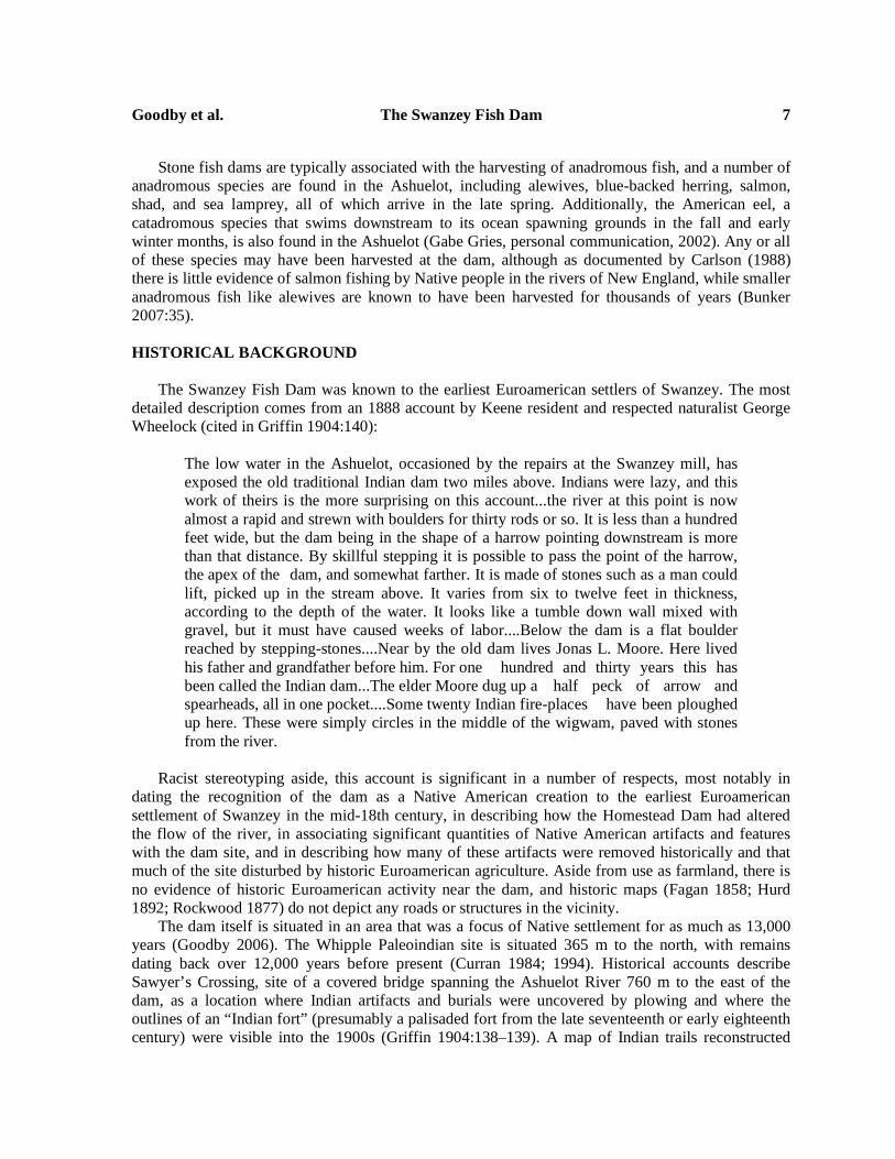
The primary goal of fieldwork at the Swanzey Fish Dam was to test the hypothesis that the dam was constructed by Native Americans by gathering evidence on its cultural affiliation and age. It was assumed that a large facility of this sort was intended to harvest substantial quantities of fish, and that surplus fish (beyond what could be consumed immediately or in the short term) would be processed nearby, likely through a combination of smoking and drying—a practice described specifically for shad, eels, and alewives in the early historic period (Gookin 1792:150). Supporting evidence for this hypothesis would include notably higher numbers of Native American artifacts and processing features in direct proximity to the fish dam than on other portions of the river terrace, indicating the dam was a focus of activity.
To test this hypothesis, shovel test pit transects were excavated along both banks of the river extending above and below the dam from the sharp hairpin bend to south of the confluence with the small drainage (Figure 2). Because of limited access to private property on the east side of the Ashuelot River, the majority of the test pits were placed on the west side. Fieldwork began with the establishment of datum points and baselines on both sides of the Ashuelot River, using a digital transit and hand-held tapes. Fifty-centimeter square shovel test pits were placed on an 8-m interval grid, with bracketing pits placed at 4-m intervals from positive shovel test pits. One-meter square excavation units were placed in areas of greatest artifact density or to explore cultural features. Shovel test pits and excavation units were excavated in arbitrary 10-cm levels within intact natural soil strata; plow zone strata were excavated and screened as a single unit. All soils were sifted through .63 cm (1/4 inch) mesh screen. On the west side of the river, a total of 278 shovel test pits, 49 1-m square excavation units, and one 1-m × 50-cm unit were completed, extending from the high
Goodby et al. The Swanzey Fish Dam 11
terrace adjacent to the hairpin bend in the river southward to the south side of the small drainage, a distance of approximately 400 m. On the east bank, a total of 43 shovel test pits was excavated in an area extending north and south of the fish dam (Figure 2).
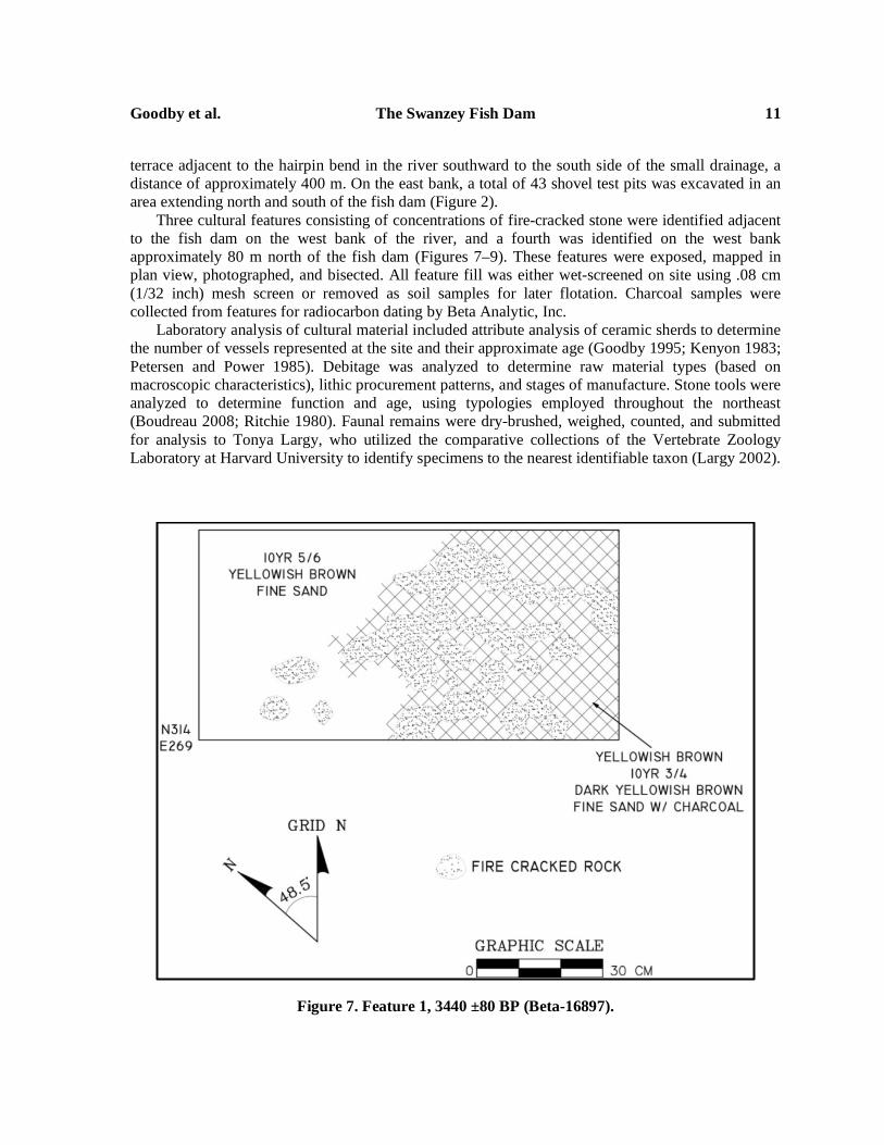
Three cultural features consisting of concentrations of fire-cracked stone were identified adjacent to the fish dam on the west bank of the river, and a fourth was identified on the west bank approximately 80 m north of the fish dam (Figures 7–9). These features were exposed, mapped in plan view, photographed, and bisected. All feature fill was either wet-screened on site using .08 cm (1/32 inch) mesh screen or removed as soil samples for later flotation. Charcoal samples were collected from features for radiocarbon dating by Beta Analytic, Inc.
Laboratory analysis of cultural material included attribute analysis of ceramic sherds to determine the number of vessels represented at the site and their approximate age (Goodby 1995; Kenyon 1983; Petersen and Power 1985). Debitage was analyzed to determine raw material types (based on macroscopic characteristics), lithic procurement patterns, and stages of manufacture. Stone tools were analyzed to determine function and age, using typologies employed throughout the northeast (Boudreau 2008; Ritchie 1980). Faunal remains were dry-brushed, weighed, counted, and submitted for analysis to Tonya Largy, who utilized the comparative collections of the Vertebrate Zoology Laboratory at Harvard University to identify specimens to the nearest identifiable taxon (Largy 2002).
Figure 7. Feature 1, 3440 ±80 BP (Beta-16897).
12 Northeast Anthropology No. 81/82, 2014
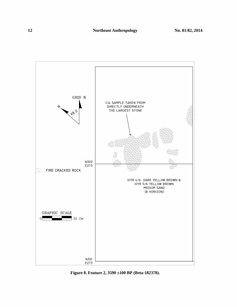
Figure 8. Feature 2, 3590 ±100 BP (Beta-182378).
Goodby et al. The Swanzey Fish Dam 13
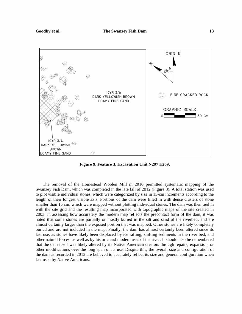
Figure 9. Feature 3, Excavation Unit N297 E269.
The removal of the Homestead Woolen Mill in 2010 permitted systematic mapping of the Swanzey Fish Dam, which was completed in the late fall of 2012 (Figure 3). A total station was used to plot visible individual stones, which were categorized by size in 15-cm increments according to the length of their longest visible axis. Portions of the dam were filled in with dense clusters of stone smaller than 15 cm, which were mapped without plotting individual stones. The dam was then tied in with the site grid and the resulting map incorporated with topographic maps of the site created in 2003. In assessing how accurately the modern map reflects the precontact form of the dam, it was noted that some stones are partially or mostly buried in the silt and sand of the riverbed, and are almost certainly larger than the exposed portion that was mapped. Other stones are likely completely buried and are not included in the map. Finally, the dam has almost certainly been altered since its last use, as stones have likely been displaced by ice rafting, shifting sediments in the river bed, and other natural forces, as well as by historic and modern uses of the river. It should also be remembered that the dam itself was likely altered by its Native American creators through repairs, expansion, or other modifications over the long span of its use. Despite this, the overall size and configuration of the dam as recorded in 2012 are believed to accurately reflect its size and general configuration when last used by Native Americans.

14 Northeast Anthropology No. 81/82, 2014
RESULTS
The Dam
The results of mapping provided the first comprehensive depiction of the size and shape of the Swanzey dam (Figures 3, 6). The dam is constructed from stones ranging in size from small boulders to fist-sized cobbles, with concentrations of smaller stones filling the gaps between the larger boulders. Some of the largest stones may have been in this location prior to construction of the dam, whose builders took advantage of their location to add other stones to form each wing of the dam. The dam is shaped like an asymmetrical “V” with two wings of unequal lengths that meet to form an apex pointing downstream. The west wing extends approximately 10 m from the west bank to the apex, while the east wing is approximately 24 m in length, extending from the apex to the east bank, where it runs parallel to the bank forming a narrow channel. No wooden posts or other associated organic remains were observed during mapping, but these would have been difficult to observe even if they had survived, as much of the dam was partially submerged and there were still significant quantities of silt and sand in and around the stones that had been deposited during the impoundment. Associated Artifacts
In the absence of datable organic remains directly associated with the dam, evidence of terrestrial
Native American sites directly associated with the dam provided the only means of establishing the dam’s cultural affiliation and age. Shovel testing revealed that Native American artifacts were distributed intermittently across both banks of the Ashuelot River. At the northern portion of the study area on the high terrace by the hairpin bend in the Ashuelot, 300 m north of the dam, scattered flakes, a few core fragments, nondiagnostic biface fragments, and a small number of extremely thin-walled ceramic sherds were distributed over a broad area. The base of a quartz Neville point was recovered from a test pit close to where Arthur Whipple had earlier recovered a volcanic Stark point eroding from the river bank (Goodby 2006:38), and a single Paleoindian artifact, a side scraper or possibly a spurred end scraper made from a slightly curved flake of weathered tan/grey rhyolite, was also recovered at this location. Between the hairpin bend and the fish dam, intermittent concentrations of rhyolite flakes, cores, and preform fragments were recovered; the limited spatial extent and number of flakes suggest these were locations where a few tools were produced at a single point in time, rather than workshop areas utilized for an extended period of time, or by large numbers of people (Goodby 2006:39). Artifacts in this area were notable for their lack of variation; no ceramics or finished tools were recovered, and only a single feature, a hearth on the edge of the river (Feature 4), was identified. The greatest number and variety of formal artifacts were recovered adjacent to the fish dam itself. This was evident in the results of the initial 8- and 4-m interval shovel testing, which produced diagnostic bifaces (Figure 10); thin-walled, ornately decorated ceramics (Figure 11); a ground-stone gouge (Figure 12); as well as calcined bone and three hearth features (Figures 7–9). The number and variety of artifacts on the west bank declined dramatically south of the dam, with only a few thin-walled ceramic sherds and small fragments of fire-cracked rock recovered in test pits on the south side of the small drainage entering the Ashuelot below the dam. The close association of Native American artifacts and features with the dam clearly indicates the dam was a focus of activity, supporting the hypothesis of its Native American construction and use. In contrast, very few Euroamerican artifacts, consisting of isolated fragments of whiteware, brick, glass, and a piece of asphalt, were recovered from the plow zone stratum of eight shovel test pits in the area of the dam. These sorts of artifacts are commonly encountered in plow zone strata, and in no way suggest there is a defined Euroamerican site here or that the dam was built or utilized by Euroamericans.
Goodby et al. The Swanzey Fish Dam 15
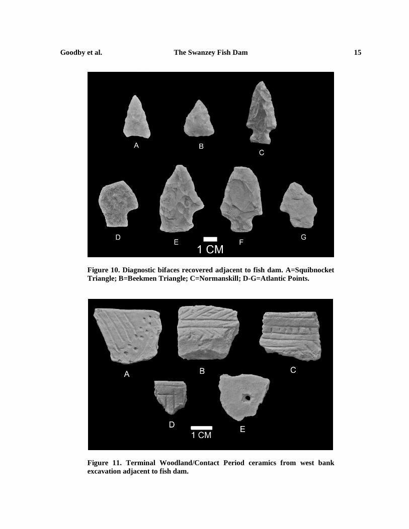
Figure 10. Diagnostic bifaces recovered adjacent to fish dam. A=Squibnocket Triangle; B=Beekmen Triangle; C=Normanskill; D-G=Atlantic Points.
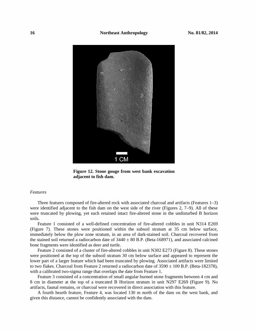
Figure 11. Terminal Woodland/Contact Period ceramics from west bank excavation adjacent to fish dam.
16 Northeast Anthropology No. 81/82, 2014
Figure 12. Stone gouge from west bank excavation adjacent to fish dam.
Features Three features composed of fire-altered rock with associated charcoal and artifacts (Features 1–3)
were identified adjacent to the fish dam on the west side of the river (Figures 2, 7–9). All of these were truncated by plowing, yet each retained intact fire-altered stone in the undisturbed B horizon soils.
Feature 1 consisted of a well-defined concentration of fire-altered cobbles in unit N314 E269 (Figure 7). These stones were positioned within the subsoil stratum at 35 cm below surface, immediately below the plow zone stratum, in an area of dark-stained soil. Charcoal recovered from the stained soil returned a radiocarbon date of 3440 ± 80 B.P. (Beta-168971), and associated calcined bone fragments were identified as deer and turtle.
Feature 2 consisted of a cluster of fire-altered cobbles in unit N302 E273 (Figure 8). These stones were positioned at the top of the subsoil stratum 30 cm below surface and appeared to represent the lower part of a larger feature which had been truncated by plowing. Associated artifacts were limited to two flakes. Charcoal from Feature 2 returned a radiocarbon date of 3590 ± 100 B.P. (Beta-182378), with a calibrated two-sigma range that overlaps the date from Feature 1.
Feature 3 consisted of a concentration of small angular burned stone fragments between 4 cm and 8 cm in diameter at the top of a truncated B Horizon stratum in unit N297 E269 (Figure 9). No artifacts, faunal remains, or charcoal were recovered in direct association with this feature.
A fourth hearth feature, Feature 4, was located 130 m north of the dam on the west bank, and given this distance, cannot be confidently associated with the dam.

Goodby et al. The Swanzey Fish Dam 17
Flaked Stone Tools Four types of lithic material—rhyolite, quartz, quartzite, and chert—were recovered, with the
latter three materials dominating the assemblage of debitage and stone tools adjacent to the fish dam. With the exception of a few small quartz core fragments, there was relatively little evidence for stone tool manufacture adjacent to the dam, in contrast to areas further to the north, where the manufacture of bifaces, primarily from rhyolite, clearly occurred. In contrast, by the fish dam, it appears that bifaces were being used, resharpened, and occasionally broken, but not necessarily replaced, reflected by small quantities of debitage and a lack of broken preforms. The close proximity to the fish dam itself may have influenced the types of activities that occurred there, with an emphasis on fishing and fish processing as opposed to tool manufacture.
Eighteen bifaces and biface fragments were recovered from both sides of the river adjacent to the fish dam. Eleven of these were nondiagnostic biface fragments. The remaining tools (Figure 10) are temporally diagnostic, and provide time markers for the construction and use of the fish dam. Diagnostic bifaces from the west bank included a quartz Squibnocket Triangle point (Figure 10A), a quartz Beekman triangle (Figure 10B), and a Normanskill point of black/green chert macroscopically similar to that from the Normanskill formation of upstate New York, recovered in direct association with a cluster of retouch flakes of the same material (Figure 10C). Four broad-bladed, stemmed bifaces identified as Atlantic points, two from each side of the river, were also recovered, one broken and partially reworked and made from light grey quartzite (Figure 10D), one extensively reworked specimen of grey chert (Figure 10E), one of olive green chert (Figure 10F), and one broken and reworked specimen of an unknown grey, possibly metamorphic stone (Figure 10G). Three of the four Atlantic points are so extensively reworked on one margin that the shoulder is almost completely obliterated, indicating that, as others have argued, they were likely used as cutting or processing tools as opposed to projectile points (Cook 1976; Custer 1991) possibly associated with fishing (Kinsey 1972:346–347; cited in Custer 1991:53).
All of the diagnostic bifaces recovered adjacent to the dam date to the Late and/or Terminal Archaic periods. The Atlantic points are a particularly sensitive diagnostic marker (Borque 1995:166–167; Dincauze 1972), having only been manufactured for a few centuries, and closely correspond to the radiocarbon dates from Features 1 and 2. Consequently, the earliest definitive occupation of the site adjacent to the dam, and by extension the earliest definitive use of the dam itself, can be placed in the first part of the Terminal Archaic Period, c. 3500–3800 B.P. Ground Stone Tools
Two ground stone tool fragments were recovered from the west bank immediately adjacent to the
fish dam. The more prominent example is the bit end of a gouge (Figure 12) made from an unidentified material. The pecked and ground groove terminated partway along its axis, though how far in relation to its overall length cannot be determined. The other specimen is a flake from a ground stone tool made from different, although still unidentified, material from the gouge. It is unclear if the flake was detached from the tool during use or production.
Ceramics
Attribute analysis of the 157 ceramic sherds recovered adjacent to the fish dam identified a
minimum of four separate vessel lots, all but one of which are stylistically and technologically similar (Figure 11). Rim sherds, at least one of which came from a vessel with a low collar (Figure 11B), were decorated with fine horizontal, vertical, and oblique lines incised with a rounded, stylus-like
18 Northeast Anthropology No. 81/82, 2014
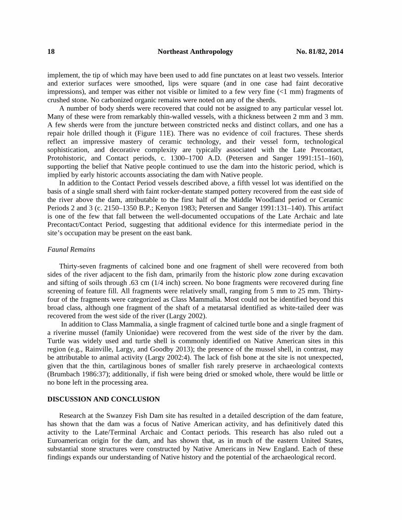
implement, the tip of which may have been used to add fine punctates on at least two vessels. Interior and exterior surfaces were smoothed, lips were square (and in one case had faint decorative impressions), and temper was either not visible or limited to a few very fine (<1 mm) fragments of crushed stone. No carbonized organic remains were noted on any of the sherds.
A number of body sherds were recovered that could not be assigned to any particular vessel lot. Many of these were from remarkably thin-walled vessels, with a thickness between 2 mm and 3 mm. A few sherds were from the juncture between constricted necks and distinct collars, and one has a repair hole drilled though it (Figure 11E). There was no evidence of coil fractures. These sherds reflect an impressive mastery of ceramic technology, and their vessel form, technological sophistication, and decorative complexity are typically associated with the Late Precontact, Protohistoric, and Contact periods, c. 1300–1700 A.D. (Petersen and Sanger 1991:151–160), supporting the belief that Native people continued to use the dam into the historic period, which is implied by early historic accounts associating the dam with Native people.
In addition to the Contact Period vessels described above, a fifth vessel lot was identified on the basis of a single small sherd with faint rocker-dentate stamped pottery recovered from the east side of the river above the dam, attributable to the first half of the Middle Woodland period or Ceramic Periods 2 and 3 (c. 2150–1350 B.P.; Kenyon 1983; Petersen and Sanger 1991:131–140). This artifact is one of the few that fall between the well-documented occupations of the Late Archaic and late Precontact/Contact Period, suggesting that additional evidence for this intermediate period in the site’s occupation may be present on the east bank. Faunal Remains
Thirty-seven fragments of calcined bone and one fragment of shell were recovered from both sides of the river adjacent to the fish dam, primarily from the historic plow zone during excavation and sifting of soils through .63 cm (1/4 inch) screen. No bone fragments were recovered during fine screening of feature fill. All fragments were relatively small, ranging from 5 mm to 25 mm. Thirty-four of the fragments were categorized as Class Mammalia. Most could not be identified beyond this broad class, although one fragment of the shaft of a metatarsal identified as white-tailed deer was recovered from the west side of the river (Largy 2002).
In addition to Class Mammalia, a single fragment of calcined turtle bone and a single fragment of a riverine mussel (family Unionidae) were recovered from the west side of the river by the dam. Turtle was widely used and turtle shell is commonly identified on Native American sites in this region (e.g., Rainville, Largy, and Goodby 2013); the presence of the mussel shell, in contrast, may be attributable to animal activity (Largy 2002:4). The lack of fish bone at the site is not unexpected, given that the thin, cartilaginous bones of smaller fish rarely preserve in archaeological contexts (Brumbach 1986:37); additionally, if fish were being dried or smoked whole, there would be little or no bone left in the processing area. DISCUSSION AND CONCLUSION
Research at the Swanzey Fish Dam site has resulted in a detailed description of the dam feature,
has shown that the dam was a focus of Native American activity, and has definitively dated this activity to the Late/Terminal Archaic and Contact periods. This research has also ruled out a Euroamerican origin for the dam, and has shown that, as in much of the eastern United States, substantial stone structures were constructed by Native Americans in New England. Each of these findings expands our understanding of Native history and the potential of the archaeological record.
Goodby et al. The Swanzey Fish Dam 19
The Swanzey Fish Dam may be the largest stone feature in New England with a confirmed precontact Native American origin. Despite this, its construction may have been relatively straightforward, involving the careful selection of an appropriately shallow, rocky stretch of the river, and the systematic rearrangements of the existing cobbles and boulders in the riverbed to form the dam, building on larger boulders that could be left in their original location. As such, the dam may not have taken long to build, and its maintenance may have been a relatively simple matter of repairing breaches caused by the early spring ice flows. What is not yet known is whether the stone dam was also the base for a wooden weir—if so, traces of the weir stakes may remain preserved in the river bottom awaiting future study. The structure of the dam also suggests how it was used, as a barrier to direct and concentrate anadromous and/or catadromous fish to where they could be trapped, netted, or speared.
Given the nearly two centuries of agricultural activity and episodic artifact collecting that has taken place at this location, the number of diagnostic artifacts and truncated features identified near the dam in this study hints at what was once a much richer site. Despite this, it is still clear that of the nearly 400 m of riverbank tested, it is the area directly adjacent to the dam itself that has the greatest concentration of features and stone tools, proving it was a focus of activity by Native people. All the diagnostic stone tools by the dam date stylistically to the Late Archaic Period, and the Atlantic-like points and the two radiocarbon dates from fire-altered stone features suggest the first centuries of the Terminal Archaic Period were a time of particularly intensive use of the dam. This is consistent with the age of the handful of other weirs and dams in New England, and may reflect a broader regional pattern of an intensification of fishing. While the nature of their use is unknown, the presence of thin-walled, ornately decorated ceramic vessels reflects the dam’s continued use in the Contact Period, consistent with the historic accounts that explicitly state the area’s first Euroamerican settlers knew of the dam’s Indian origins.
Finally, the example of the Swanzey dam should encourage archaeologists to look for others, both in historic accounts and in the beds of modern rivers and streams that are increasingly returning to their natural levels with the removal of the nineteenth-century dams that hid them from archaeological investigation, and to understand these features as focal points in Native American cultural geography. ACKNOWLEDGMENTS. Research at the Swanzey Fish Dam was supported by the Faculty Development Fund of Franklin Pierce University and by the Monadnock Institute of Nature, Place and Culture. Permission to conduct archaeological testing was granted by the late Frank Worcester, the Yale University School of Forestry, and Public Service Company of New Hampshire. Art Whipple is thanked for sharing his extensive knowledge of southwestern New Hampshire archaeology and for introducing the senior author to the Swanzey Fish Dam site in 2002. Information on anadromous fish in the Ashuelot River was provided by Gabe Gries of the New Hampshire Department of Fish and Game. Garrett Evans, Gail Golec, Martha Pinello, and Dennis Howe served as field assistants. Mark Greenly and Garrett Evans directed mapping of the site, and produced the maps in Figures 2 and 3, respectively. Dennis Howe completed the initial drafts of feature drawings. Artifact photography was completed by Steve Bayly. Tonya Largy conducted analysis of calcined bone. Tracy Botting edited the final manuscript prior to submission. The greatest thanks go to the archaeology students of Franklin Pierce University, whose hard work, enthusiasm, and interest in the past made this research possible. REFERENCES CITED Banks, Marc
1990 Aboriginal Weirs in Southern New England. Bulletin of the Archaeological Society of Connecticut 53:73–83.
20 Northeast Anthropology No. 81/82, 2014
Borque, Bruce J. 1995 Diversity and Complexity in Prehistoric Maritime Societies: A Gulf of Maine Perspective. Plenum
Press, New York. Boudreau, Jeff
2008 A New England Typology of Native American Projectile Points. Freedom Digital, Ashland, MA. Brumbach, Hetty Jo
1986 Anadromous Fish and Fishing: A Synthesis of Data from the Hudson River Drainage. Man in the Northeast 32:35–66.
Bunker, Victoria 2007 Time and Place: The Archaeology of the Eddy Site. The New Hampshire Archeologist 46–47.
Carlson, Catherine 1988 Where’s the Salmon? A Reevaluation of the Role of Anadromous Fisheries to Aboriginal New
England. In Human Holocene Ecology in Northeastern North America, edited by George P. Nicholas, pp. 47–80. Plenum Press, New York.
Coffin, Claude C. 1947 Ancient Fish Weirs along the Housatonic River. Bulletin of the Archaeological Society of Connecticut
21:35–38. Connaway, John M.
2007 Fishweirs: A World Perspective with Emphasis on the Fishweirs of Mississippi. Mississippi Department of Archives and History, Jackson, MI.
Cook, Thomas G. 1976 Broadpoint: Culture, Phase, Horizon, Tradition, or Knife? Journal of Anthropological Research
32:337–357. Curran, Mary Lou
1980 Prehistoric Settlement Patterns in the Lower Ashuelot River Valley, 1978. Report to the State of New Hampshire Historic Preservation Office. Department of Anthropology, University of Massachusetts, Amherst.
1984 The Whipple Site and Paleo-Indian Tool Assemblage Variation: A Comparison of Intrasite Structuring. Archaeology of Eastern North America 12:5–40.
1994 New Hampshire Paleo-Indian Research and the Whipple Site. The New Hampshire Archaeologist 33/34:29–52.
Custer, John F. 1991 Notes on Broadspear Functions. Archaeology of Eastern North America 19:51–73.
Décima, Elena B., and Dena F. Dincauze 1998 The Boston Back Bay Fish Weirs. In Hidden Dimensions: The Cultural Significance of Wetland
Archaeology, edited by Kathryn Bernick, pp. 57–72. University of British Columbia Press, Vancouver, BC. Dincauze, Dena F.
1972 The Atlantic Phase: A Late Archaic Culture in Massachusetts. Man in the Northeast 4:40–61. 1976 The Neville Site: 8,000 Years at Amoskeag, Manchester, New Hampshire. Peabody Museum
Monographs No.4. President and Fellows of Harvard College, Cambridge, MA. Fagan, L.
1858 Map of Cheshire County, New Hampshire. Smith & Morely Publishers, Philadelphia, PA. Godwin, Luke
1988 Around the Traps: a Reappraisal of Stone Fishing Weirs in Northern New South Wales. Archaeology of Oceania 23:49–59.
Goodby, Robert G. 1995 Native American Ceramics from the Rock’s Road Site, Seabrook, New Hampshire. The New
Hampshire Archeologist 35(1):46–60. 2006 11,000 Years on the Ashuelot. In Where the Mountain Stands Alone: Stories of Place in the
Monadnock Region, edited by Howard Mansfield, pp. 33–43. University Press of New England, Hanover, NH.
Goodby et al. The Swanzey Fish Dam 21
Goodby, Robert G., Brooke Shunning, and Quinn-Monique Ogden 2004 A Native American Stone Fish Dam in Southwestern New Hampshire. Paper presented at the 44th
Northeastern Anthropological Association Meetings, Hanover, NH. Gookin, Daniel
1792 Historical Collections of the Indians in New England. Collections of the Massachusetts Historical Society 1:141–227.
Griffin, Simon G. 1904 A History of the Town of Keene. Sentinel Printing Company, Keene, NH.
Guzy, Dan 2001 Fish Weirs in the Monocacy and Potomac Rivers. Maryland Archaeology 37(2):11–21.
Haviland, William A., and Marjory H. Power 1994 The Original Vermonters. University Press of New England, Hanover, NH.
Hurd, D. H. 1892 Town and City Atlas of the State of New Hampshire. D. H. Hurd, Boston, MA.
Johnson, Frederick 1942 The Boylston Street Fishweir. Philips Academy Foundation, Andover, MA.
Johnston, Richard B., and Kenneth A. Cassavoy 1978 The Fishweirs at Atherly Narrows, Ontario. American Antiquity 43(4):697–709.
Josselyn, John 1675 An Account of Two Voyages to New England, Made in 1638 and 1663 (2nd ed.). G. Widdowes,
London. Kinsey, W. Fred
1972 Archaeology in the Upper Delaware Valley. Pennsylvania Historical and Museum Commission Anthropological Series No. 2. . Pennsylvania Historical and Museum Commission, Weatherly, PA.
Kenyon, Victoria B. 1983 River Valleys and Human Interaction: A Critical Evaluation of Middle Woodland Ceramics in the
Merrimack River Valley. Unpublished Ph. D. dissertation, Boston University. Largy, Tonya
2002 Analysis of Bone and Shell from 27CH27, Swanzey, New Hampshire. Manuscript on file, Department of Anthropology, Franklin Pierce University, Rindge, NH.
Lutins, Allen 1992 Prehistoric Fishweirs in Eastern North America. Unpublished M.A. thesis, Department of
Anthropology, State University of New York at Binghamton. Lutins, Allen, and Anthony P. DeCondo
1999 The Fair Lawn/Paterson Fish Weir. Bulletin of the Archaeological Society of New Jersey, 54. Ogden, Quinn-Monique
2004 The Swanzey Fish Dam in Comparison to Native Dams across Eastern North America. Unpublished senior thesis, Department of Anthropology, Franklin Pierce University, Rindge, NH.
Peck, Rodney M. 1977 Stone Fish Traps in the Upper Pee Dee River. The Chesopiean 15(1–2):2–8.
Petersen, James B., and Marjory Power 1985 Three Middle Woodland Ceramic Assemblages from the Winooski Site. In Ceramic Analysis in the
Northeast: Contributions to Methodology and Culture History. Occasional Publications in Northeastern Anthropology 9:109–159.
Petersen, James B., Brian S. Robinson, Daniel F. Belknap, James Stark, and Lawrence K. Kaplan 1994 An Archaic and Woodland Period Fish Weir Complex in Central Maine. Archaeology of Eastern North
America 22:197–222. Petersen, James B., and David Sanger
1991 An Aboriginal Ceramic Sequence for Maine and the Maritime Provinces. In Prehistoric Archaeology in the Maritimes: Past and Present Research, edited by Michael Deal. The Council of Maritime Premiers, Reports in Archaeology 8:121–178.

22 Northeast Anthropology No. 81/82, 2014
Pfeiffer, John E. 1983 Bashan Lake: 4500 Years of Prehistory. Bulletin of the Archaeological Society of Connecticut 46:45–
53. Potter, Chandler E.
1856 History of Manchester. C.E. Potter Publishers, Manchester, NH. Price, Chester
1967 Indian Trails of New Hampshire. The New Hampshire Archeologist 14:1–12. Proctor, Mary
1930 The Indians of the Winnipesaukee and Pemigewasset Valleys. Towne & Robie, Franklin, NH. Rainville, Celine, Tonya Largy, and Robert G. Goodby
2013 The Raft Bridge Site (27HB299): A Multi-Component Site In Peterborough, New Hampshire. The New Hampshire Archeologist 52.
Ritchie, William A. 1980 New York Projectile Points: A Typology and Nomenclature. New York State Museum, Albany, NY.
Rockwood, C. H. 1877 Atlas of Cheshire County New Hampshire. Comstock & Cline, New York.
Schindler, Bill 2008 Rethinking Middle Woodland Settlement and Subsistence Patterns in the Middle and Lower Delaware
Valley. North American Archaeologist 29(1):1–12. Speck, Frank G.
1970 Penobscot Man. Octagon Books, New York. Strandberg, Carl H., and Ray Tomlinson
1969 Photoarchaeological Analysis of Potomac River Fish Traps. American Antiquity 34(3):312–319. Teehan, Jack
1950 Low Water Reveals Indian Dam on Ashuelot River in Swanzey. The Keene Sentinel. 12 July. Watts, Dan
2009a Evidence of a Prehistoric Two-weir Fish Trap at China Lake Stream, Sebasticook River, Winslow, Maine. Electronic document, http://tispaquin.blogspot.com/2009/09/ evidence-of-prehistoric-two-weir-fish.html
2009b Prehistoric Stone Fish Weir, West Branch Sebasticook River, Pittsfield, Maine. Electronic document, http://tispaquin.blogspot.com/2009/10/prehistoric-stone-fish-weir-west-branch.html