the structure of the ne cap de creus peninsula relationships with … · 2008. 4. 16. · the...
TRANSCRIPT

>\£ML5Vi>M
*<KT^IÍ&VC
VIp
ahoiv
vÊ
\S^
si-i
_ ,-w
^r «
hj¿
^1 V
SA
V*
STY
w>
,-^
*^S^5
?-
^¿¿¿SM
l**^
L^V
^as^H
-:
'ál
v^^^'uvviftS *M
Vt
K S
Al
v^xi
^ &
Í^^W
- Wía-V
Ci
úís^n-£
r >v
^^^
>^^^2cfe
^*t-^
^^^§
^S
fe^^^X
^!
**:-xv
"^
vkU
\w•»
k
V
^•^£cvK£rr §sï
fc^-^t^^liî—
-^.^JW^T! g|¡ '
^3^--
^íXv
,;-.\U«-4.

THE STRUCTURE OF THE NE CAP DE CREUS PENINSULA.RELATIONSHIPS WITH METAMORPHISM AND MAGMATISM
Elena Druguet
Estudi realitzat a la Unitat de Geotectónica, Departament de Geologia, de la Facultat deCiències de la Universitat Autònoma de Barcelona, sota la direcció del Dr. Jordi CarrerasPlanells, per optar al grau de Doctora en Ciències Geològiques.
Signat: Elena Druguet Tantinà
El director del treball: Jordi Carreras Planells
Bellaterra, Juny 1997

Cover design: Jordi Carreras


AGRAÏMENTS
manifestar el meu agraïment a totes aquelles persones i institucionsque d'alguna manera han collaborât en la realització d'aquest treball.Expressaré aquest agraïment segons els diferents aspectes en que s'hanbasat aquestes contribucions, amb la Intenció de no oblidar-me de ningú.De totes maneres, voldria que aquells que per oblit no constin en aquestallista em disculpin i rebin un doble agraïment.
En primer lloc a en Jordi Carreras, director d'aquest treball. La sevacol·laboració ha estat decisiva en tots els aspectes relacionats ambaquesta tesi, des del seguiment del treball de camp fins a la revisió finaldel mecanuscrit, passant per múltiples i profitoses discussionsrelacionades amb la geologia estructural d'aquesta zona.
Col·laboradors en el treball de camp: Sebastià Gonzalo (expert enbarranqulsme i supervivència}}, Oscar Bou, Áurea Ponsa, Yukiko Ohtomo íFu Guofei.
Preparació de mostres i anàlisis: Jaume Quer i altres membres del Serveide preparació de làmines primes del Departament de Geologia de la ¿M/3;Servei Científico-Tècnic de la UB; Ifremer (&RGM) de Brest .
Suport científic: Cees Pa&schler, Gerard Bosslère, Donny Hutton, PereEnrique, Antoni Teixell, Paco Martínez, Joan Reche, María Luisa Arboleya,Joan Soldevila, Gumer Galán, Gemma Alias, Joan Carles Melgarejo, CarolSimpson, Hemin K.oyi.
Revisió de l'anglès: Anthony Teixell.
Suport Informàtic: Carles Aranda i Albert Grlera (dlgltalltzacló delsmapes), Jordi Clrés, Martí Carreras, Tonl Domingo i Glòria Druguet(assesors digitals], José Luís Vega (col·laborador en bases de dades}.
Suport moral i alimentari: als meus pares i germanes, que de formaIncondicional sempre m'han recolçat. També als companys i companyes delDepartament, especialment a en Joan Carles Ortiz i a en Xurxo Fernández.També vull agrair a la família Fortuny, de la fonda Cala d'Or de Cadaqués,els àpets de "treballador" que m'han ofert.
Aquesta tesi ha estat financiada pel MEC mitjançant una beca doctoralassociada al projecte P&9Î-O477 (DGICYT). Part de l'edició de la tesi haanat a càrrec del projecte P&94-O6&5. Els programes "AccionesIntegradas" del mateix Ministeri han facilitat l'Intercanvi amb altresequips de recerca estrangers (Univ. Hantes, França i Univ. Malnz,Alemanya}.

ABSTRACT
This work concentrates in the tectonics of the deepest-seated domains exposed in thenorthern Cap de Creus peninsula, and in the associated magmatism andmetamorphism. The Cap de Creus peninsula forms the most easterly outcrop ofPaleozoic basement along the Axial Zone of the Pyrenees, in which penetrativefoliations, metamorphism and magmatism are Hercynian in age. Rocks outcropping inthe study area correspond to a metasedimentary sequence with minor interlayeredmeta-igneous rocks.The presence of a metamorphic gradient, where grade increases towards the north,reflects a prograde low pressure regional metamorphism, initiated during the earlydeformational events, and ranges from the chlorite - muscovite zone in the south tothe sillimanite - K-feldspar zone in the north. Locally, in medium and high gradedomains, small migmatite areas are present, together with a sequence of calc-alkalinegranitoids, emplaced sequentially from the more basic magmas to the more acid ones.A swarm of pegmatite dykes extends over the anatectic and perianatectic domains upto the cordierite-andalusite zone. A retrograde metamorphism is heterogeneouslydistributed along late structures, especially along mylonitic bands, and appearssuperimposed on the prograde metamorphic pattern.Polyphasic structures are interpreted as part of a progressive deformational history,with an evidenced continuity of events from prograde to retrograde metamorphicconditions. However, three main deformational events have been distinguished. Theearly event (Di) developed a penetrative, originally shallow-dipping, schistosity (81).Afterwards, a sequence of regional deformation events caused steep structures. Eachevent was inhomogeneous in space and characterized by progressive non-coaxialdeformation, leading to a complex structural pattern. The D2 event produced NE-SWtrending folds affecting the Si schistosity in prograde metamorphic conditions. Fold-related strain gradients across the area define a structural zonation, with domains oflow and high strain and a broad shear zone-like geometry. High strain deformationtook place preferentially in the north, and was associated to migmatization andgranitoid emplacement. A transitional stage between D2 and D3 events (named D2-3)is characterized by the development of sub-vertical E-W trending folds. Thisdeformational stage took place around the time of peak metamorphism grading to hightemperature retrogression in the north (where the pegmatite dyke swarm emplacedsyntectonically), but under clear retrograde conditions in central and southerndomains. Progressive deformation at retrograde conditions produced NW-SE-trendingD3 structures and gave rise to a second structural zonation, with a fold belt coveringthe southern part of the studied area, and a mylonite belt tracking the higher grademetamorphic zones.The studied relationships between high temperature structures (D2 and D2-3) in themetasediments and the deformational features in the granitoids and pegmatitessupport the synchronicity of deformational processes and magmatism. In addition,strain and kinematic analysis of these structures reveals that, dispite the existence ofcomplex relationships between geometry and kinematics, deformation took place in abroadly transpressive regime, involving subvertical extension and NNW-SSEsubhorizontal bulk shortening with a dextral component.

RESUM
Aquest estudi es centra en la tectònica dels dominis més profunds que afloren a lapenínsula del Cap de Creus, així com en el magmatisme i metamorfisme associats.La península del Cap de Creus constitueix l'aflorament de sòcol paleozoic mésoriental de la Zona Axial pirinenca, en la qual les deformacions penetratives, elmetamorfisme i el magmatisme són d'edat herciniana. Les roques que afloren a l'àread'estudi corresponen a una seqüència metasedimentària amb esporàdiquesintercalacions de roques metaígnies.La presència d'un gradient metamòrfic amb augment del grau cap al nord, reflexa unmetamorfisme regional prògrad del tipus de baixa pressió, iniciat durant els primersestadis de deformació, i comprèn des de la zona de la clorita - moscovita al sud fins lazona de la sil.limanita - feldspat potàssic al nord. Localment, en dominis de grau mig ialt, hi ha unes reduïdes àrees migmatítiques juntament amb uns granitoidscalcoalcalins, emplaçats seqüencialment des dels magmes més bàsics fins als mésàcids. Ocupant tot els dominis anatèctic i perianatèctic, fins la zona de la cordierita-andalusita, s'extén un eixam de dics pegmatítics. El metamorfisme retrògrad esdistribueix de forma heterogènia al llarg de les estructures tardanes, especialmentassociat a bandes milonítiques, i es superposa sobre les zones anteriors demetamorfisme prògrad.Les estructures tectòniques polifàsiques s'han interpretat com el resultat d'una històriadeformativa progressiva, amb una evident continuïtat d'episodis esdevinguts des decondicions metamòrfiques progrades fins a retrògrades. Per tal d'exposar aquestaevolució tectònica, s'han diferenciat tres episodis principals. El primer episodi (Di)donà lloc a una esquistositat penetrativa (81), que presumiblement tindria unadisposició original sub-horitzontal. Posteriorment s'inicià una seqüència dedeformacions caracteritzada pel desenvolupament d'estructures dretes. Ladeformació en cada fase fou heterogènia en l'espai, progressiva i de caràcter no-coaxial, donant lloc a una complexa configuració estructural. L'episodi Ü2 va generarplecs d'orientació NE-SW que afectaren l'esquistositat Sr en condicions demetamorfisme prògrad. La presència de gradients de deformació al llarg d'aquestesestructures de plegament defineix una zonació estructural, amb dominis d'alta i baixadeformació i amb una geometria anàloga a la de les zones de cisalla. Les zones demés deformació es situen a la part septentrional, associades a processos demigmatització i a l'emplaçament de granitoides. S'ha considerat un estadi de transició(D2-3), entre els episodis D2 i Ds, caracteritzat per la formació de plecs subverticalsde direcció E-W. Al nord, aquest estadi de deformació es produí en condicionsproperes al clímax metamòrfic i sincrònic amb l'emplaçament de les pegmatites,mentre que a les zones central i meridional ho feu en condicions claramentretrògrades. La progressió de la deformació en condicions retrògrades generà lesestructures D3, de direcció NW-SE, que en el sud conformen una banda de plecs i enel nord una faixa milonítica sobre les roques més cristal·lines. Aquest fet dona lloc auna segona zonació estructural.L'anàlisi de les relacions entre les estructures d'alta temperatura (D2 i 02-3) presentsals metasediments i els trets deformacionals als granitoides i pegmatites recolça elsincronisme entre els processos deformatius i el magmatisme. Per altre banda,l'anàlisi de la deformació i de la cinemática d'aquestes estructures mostra que, apesar d'existir unes complexes relacions entre geometria i cinemática, la deformacióes produí en un règim tectonic transpressiu, en el que hi hauria implicats una extensiósubvertical i un escurçament general NNW-SSE amb un component direccionaldextre.

ABBREVIATIONS AND SYMBOLS
CPLD1,D2, D2-3, D3AA
F1.F2, F2-3, F3L1, L2, L2-3, L3LmInflsLP-HTPPLP-TP-T-tRSSí, S2S1.S2, S2-3, S3SerSeSiSmSsSs/1TRRWk(ú
X, Y, Z axes
MineralsAbAlAnAndAnnBtCd or CrdChiEastGrGtHblKfs or K-feldsparKyLMsOrPhlPIPxPyQtzSidSilSpStTourm
crossed polarised lightsequential deformation eventsarea changefolds related to D1, D2 and D 3fold axes and lineations related to Di , D2 and Dsmylonitic stretching lineation (sometimes included in L3)lines of no finite longitudinal strainlow pressure-high temperatureplane polarised lightpressure temperaturepressure temperature timeaxial ratio of sectional ellipses of finite strainstretch of a lineprincipal finite stretchesfoliations related to D 1 , D2 and D 3Granulation cleavageexternal foliation with respect to a porphyroblast with inclusionsinternal foliation in a porphyroblast with inclusionsmylonitic foliationbedding surfacebedding-parallel Si foliationtourmaline-rich rimkinematic vorticity numberrotation of the principal stretches (Sí, S2), rigid rotation componentprincipal axes of strain
albitealmandineanortiteandalusiteannitebiotitecordieritechloriteeastonitegrossulargarnethornblendepotassium feldsparkyaniteliquid phasemuscoviteOrlósephlogopiteplagioclasepiroxenepyropequartzsiderophyllitesillimanitespessartineslauroliletourmaline

CONTENTS
1 INTRODUCTION 1
1.1. Previous work and state of the art 5i
i 1.1.1. Recent advances on deep-seated tectonics 51 1.1.2. Present knowledge of the geology of the Hercynian basement of the
Pyrenees 6
\ 1.1.3. Previous work and state of the art on the Cap de Creus geology 7
• 1.2. Objectives and procedures 9ii
2 GEOLOGICAL SETTING 11! 2.1. The metasedimentary sequence and other lithologies 13
2.2. Tectonic setting 20
2.3. Setting of the metamorphism and plutonism 23
i
3 METAMORPHISM AND MAGMATiSM 253.1. Zonations of metamorphism and magmatism 29
3.2. Metamorphic rocks 30
i 3.2.1. Metapelites and metagreywackes 30
3.2.2. Interlayered rocks 35
: 3.2.3. The Port de la Selva gneiss and the metabasites 35
! 3.2.4. Mylonites 37
3.3. Migmatites and magmatic rocks 39
3.3.1. The pegmatite dyke swarm 39
3.3.2. The migmatite complexes 40
3.3.3. A discussion on the magmatic history 46
! 3.4. P-T estimates 47
4 THE STRUCTURE 49
4.1. Early deformations 51
i 4.1.1. Penetrative early deformation 51
i 4.1.2. Other evidence of early tectonics 54
4.2. Post-Dl structural zonation as a result of complex space-time history 55
4.3. D2 prograde folding event 59
4.3.1. Structures in the low strain domains 60
4.3.2. Structures in the high strain domains 65
4.4. D2-3 E-W folding stage 69
4.4.1. Progression of D2 to D2-3: the Culip-Cap de Creus example 69
4.4.2. Overprinting of D2 by D2-3 744.5. Late structures: D3 folds and shear zones 79
! 4.5.1. Late f olds 79i %
4.5.2. Shear zones 88

5 RELATIONSHIPS BETWEEN DEFORMATION, METAMORPHISM AND MAGMATISM 935.1. Metamorphism and deformation 95
5.2. Migmatite complexes and deformation 975.2.1. Magmatism and deformation 97
5.2.2. Migmatites and deformation 101
5.2.3. Discussion on syntectonic magmatism and migmatization 103
5.3. Pegmatite dyke swarm and deformation 104
5.3.1. Pegmatites in domains of progressive D2 to D2-3 deformation 105
5.3.2. Pegmatites in domains of low D2-3 deformation 109
5.3.3. Pegmatites in domains of overprinting of D2 by D2-3 109
5.3.4. The emplacement of the pegmatite dykes 110
6 STRAIN AND KINEMATIC ANALYSIS OF HIGH TEMPERATURE STRUCTURES 1136.1. Analysis in horizontal sections 116
6.1.1. Dextral deflection: first approach 116
6.1.2. Kinematic indicators 118
6.1.3. Second approach 119
6.1.4. Strain determination 120
6.2. Three-dimensional analysis 129
7 DISCUSSION AND CONCLUSIONS 1357.1. Regional aspects 1377.2. Conceptual aspects 140
REFERENCES 143

1 INTRODUCTION

The space and time recurrent association ofdeformation, magmatism and metamorphism in midto deep crustal levels in erogenic belts is well known
since long time ago. However, only recent works
have evidenced and interpreted such links on the
basis of detailed analysis of structures, which recordan often complex evolution. In such settings, an
approach based exclusively on the distinction ofdifferent tectonic phases and interkinematic periods
is often inadequate, because progressivedeformation episodes are involved and, moreover,because magmatic episodes appear to be stronglycontrolled by the overall deformation rather thanbeing independent events with solely a spatialcoincidence.
Close looks at internal structures of igneous rocksas well as the structural relationships betweenigneous bodies and country rock have become animportant tool for the understanding of the evolutionof this sort of geological settings. Also recently,approaches involving detailed structural analysis onall scales combined with kinematical analysis havebecome habitual. Such kind of approach is arequirement when characterizing the geotectonicsettings governing the structural transformations inhigh-grade terrains. However, in some settings,simplistic links established between a determinedshear kinematic indicator and an assumed crustalscale tectonic regime have often lead toquestionable results, evidenced by presentation ofcontroversial models. In this context, the Hercynian
basement of the Pyrenees conforms a piece of crustwith a huge accumulation of geological data and
also literature, but where diverse interpretationshave arisen, some of them highly contradictory.
Most of these contradictions arise from different
interpretations of the structural evolution, mainly inareas where deep-seated crustal levels areexposed.
The Cap de Creus peninsula is one of these areas
where deep seated crustal levels are well exposed.In consequence, a detailed knowledge of its tectonicevolution will not only help to highlight the evolutionof the Hercynian basement of the Pyrenees but alsowill provide some new ideas on the mid-lower crusttectonics and related phenomena in an erogenicbelt.The Cap de Creus peninsula forms the mosteasterly outcrop of Hercynian basement of the AxialZone of the Pyrenees (Fig. 1).The Axial Zone consist on an elongated area alongthe Pyrenean chain. In this Axial Zone, together withthe North Pyrenean massifs, rocks from theHercynian basement outcrop due to both Hercynianand Alpine exhumation. In outline, while along thecentral and western part of the Pyrenean AxialZone, the Hercynian basement consists ofpredominantly upper crustal rocks, towards theeastern Axial Zone deep seated rocks becomemore abundant. Hercynian basement rocks can beclassified in three groups:
Hercynian basement
Mesozoic Tertiary
Tertiary in Forelands
EBRO
Fig. 1. Main structural units of the Pyrenean belt (After Teixell 1990).

I I A
lpin
e b
elt
Her
cyni
an b
elt
BA
Y O
F B
IZC
AIA
DC
NO
ST
IAA
QU
ITA
NIA
N
BA
SIN
TR<
>IS
SE
IGN
EU
RS
A
RIZ
E
Her
cyni
an g
rani
toid
s
pre-
Her
cyni
an g
rani
toid
s (o
rthog
neis
ses)
J S
iluria
n to
Wes
tpha
lian
'• í 1
3 Lo
wer
Pal
aeoz
oic
and
Pre
cam
bria
n (?
) se
ries
Fig.
2: S
ketc
h m
ap o
f the
Her
cyni
an o
utcr
ops
in N
E S
pain
(C
arre
ras
& C
apel
là 1
994)
.

(¡) Sedimentary rocks and metasedimentary
equivalents (ii) gneiss series, mainly orthotypes,
derived from pre-Hercynian granitoids and (iii)
Hercynian granitoids. Penetrative alpine structures
in this zone are generally poorly developed and the
main internal deformation features can be attributed
to the Hercynian events (Fig.2).
In this setting, the rocks in the Cap de Creus
peninsula represent medium to deep-seated
structural levels in the Mattauer (1973) sense, and
are affected by low to high-grade Hercynian
metamorphism. This thesis is concentrated in the
study of the deepest domains exposed in the
northern Cap de Creus (Fig. 3), from low grade
(chlorite muscovite) metasediments to high grade
metamorphic rocks and associated igneous rocks.
This area is particularly suitable to the
understanding of complex deformation processes,
as well as the metamorphism and plutonism
occurring in the middle crust during the Hercynian
orogeny. This interest is due to several reasons: the
presence of a good profile across the middle crust,
available in only 5 kilometres horizontal distance,
and the exceptional outcrop conditions for structural
and petrological studies. Another reason that avail
the singularity of this area is the a priori absence of
significant alpine structural reworking, although this
statement will be briefly discussed later by
comparison with similar areas in the Pyrenees
where alpine reworking has been assumed.
| | Quaternary
^ Neogene faults
quartz dykesMylonites
Hercynian granodiorite
lower Palaeozoic-Precambrian sequences:
] UPPER SERIES
LOWER SERIES
amphlbolite gneissI chlorlte-muscovite zoneII biotitezoneIII cordiente andalusite zoneIV sillimanite zoneV migmatite complexes
Fig. 3. Geological map of the Cap de Creus peninsula (modified from Carreras and Losantos, unpublished).
1.1. PREVIOUS WORK AND STATE OF THE ART
Objectives of this work were defined taking into
account the state of the art in three different related
fields: 1. The recent developments and
achievements in structural geology of deep seated
levels specially concerning two aspects: strain
regime analysis and syn-magmatic tectonics. 2. The
Pyrenean basement controversy arisen when
extensional tectonics was introduced as a main
event in the Hercynian evolution and 3. The slanted
knowledge of the Cap de Creus geology, where
although considerable literature existed, this was
concentrated mainly on two aspects shear zones
and petrology of magmatic rocks, while the early
tectonic evolution remained poorly understood.
1.1.1. RECENT ADVANCES ON DEEP-SEATED
TECTONICS
In last two decades there has been a growing
interest in different aspects and scales of deep-
seated deformation processes involving a prevalent
ductile flow concentrated along deformation bands,
specially shear zones. This was evidenced, for
instance, in the conference Shear zones in rocks
that took place in Barcelona in 1979, which included
a field trip precisely in Cap de Creus. In the past
recent years, this growing interest has been going
on, embodying many more structural and tectonic
aspects as well as embracing multiple new
methodologies and techniques, which lead to more
accurate reconstructions of structural processes. In

6 í
this perspective, where one of the main objectives isto obtain tectonic models, some see large
advantages, whereas others see many dangers inthis urge to "modelling".The characterization of deformation is a main
objective in studies focused in deep seatedstructural levels, in order to reconstruct the tectonic
regimes operating in the crust and to interpret
associated processes like metamorphism andmagma emplacement. Since thé landmarkpublication by Ramsay (1967), much quantitative
structural data have been collected and thecombined use of both observational strain andkinematic analysis and numerical approaches(Talbot, 1970, De Paor 1986, Passchier & Trouw1996), have contributed to significant improvement.It is now commonly accepted that deformation indeep zones can depart from plane strain flow andconsequently the correlation between structural andkinematic elements can be far more complex thanassumed some years ago (e.g. no uniquerelationship exists between fold or boudin axes andprincipal stretching directions). Consequently, fieldand laboratory data, .which drive to strain andkinematic determinations, need to be carefullyevaluated in order to achieve a specificdeformational regime. The transpressional-transtensional models, introduced by Harland(1971) and kinematically modelled by Sanderson &Marchini (1984) and Robin & Cruden (1994), havemany applications to these geotectonicbackgrounds, although the practical value of theseapproaches will require to deepen in the knowledgeof how structures form in deformation settings otherthan pure and simple shear.In addition, in the study of processes in orogenicbelts, multidisciplinary approaches are required, andhave been used by many workers and many timesdata is presented in terms of three binaryrelationships: deformation-plutonism, plutonism-
metamorphism and metamorphism-deformation(Karlstrom & Williams 1995).The metamorphic-deformational approach involvescharacterization of pressure-temperature-timehistory (P-T-t) in relation to deformational regimesand thus leads to reconstruction of thetectonometamorphic evolution. Established relationsbetween successive metamorphic zones anddeformation phases have been worked out with the
aid of microstructures (Zwart 1963, 1979; Spry1969). Interpretation of microfabrics suggests that
peak metamorphism coincides with deformation inmany orogenic belts (Bell et al. 1986).
Relationships between deformation and magmatism
are typically investigated by comparing deformation
fabrics and structures in igneous intrusions (fromplutons to small veins) and in adjacent country
rocks. A particular established analytic method isthe measurement of the anisotropy of magnetic
susceptibility (AMS) in igneous intrusions, whichallows determination of weak magmatic fabrics(Borradaile 1988). In some cases, variations in
shape and intensity of the susceptibility ellipsoidgives information on the kinematics of magmaemplacement (Bouchez et al. 1990, Cruden andLauneau 1994). As deduced from many studies,granites may be fundamentally "syntectonic".Moreover, synkinematic intrusions are commonlyassociated to high-strain zones formed at deepcrustal levels (Bossière 1980, Reavy 1989, Ingram& Mutton 1994, McCaffrey 1994, Carreras &Druguet 1994a, Karlstrom & Williams 1995), thusarising the question of what the precise relationshipis between the magmatic processes and thedeformational processes. It is now accepted bymany authors that major faults and shear zonesmay control the localization of granitoid bodies (seeMutton-1988,1997 for reviews), and that there is noa priori reason to believe in regional extension asthe unique tectonic regime which permits graniteemplacement (Paterson & Fowler 1993). This hasbeen documented for dilational sites occurring intranscurrent (Castro 1986, Mutton & Reavy 1992)and extensional systems (Tobisch et al. 1986), aswell as for contractional zones (Blumenfeld &Bouchez 1988, Ingram & Mutton 1994, Davidson etal. 1996). The idea of a siting control has led tomodels which link the genesis of granitoids to thelarge scale deformational thickening which occurs,for example, in transpressional zones (D'Lemos etal. 1992).
1.1.2. PRESENT KNOWLEDGE OF THEGEOLOGY OF THE HERCYNIAN BASEMENT OFTHE PYRENEESAs stated above, the geology of the Hercynianbasement of Pyrenees has been frequently used toconceive models for the architecture and

geotectonic regime in orogenic belts. While earlierI
models concentrated on the spatial variations of
stylé across different structural levels (Sitter & Zwart
1960, Zwart 1963) and the related metamorphic
evolution, more recent interpretations emphasize
the temporal changes of tectonic regime, with
reference to the role of either extension (Eeckhout &
Zwart 1988, Vissers 1992, Soûla et al. 1986) or
transpression in this orogenic setting (Carreras &
Capellà 1994, Gleizes et al. 1997).
It is not the aim of this introduction to give a detail
account of the main features of the Hercynian
geology of the Pyrenees, neither to discuss in detail
the present day problems. A deep treatment of
these aspects is included in the Pyrenean synthesis
treatise (BRGM-ITGE 1997). Only a short mention
of some crucial questions to the Hercynian geology
of the Pyrenees will be given, based on a succinct
review of the main problems about the Hercynian
basement geology of the Pyrenees presented by
Carreras (1988). The problems mentioned in this
summary (op. cit.) refer to following aspects. First,
the significance of the orthogneiss sheets is not yet
well established. These rocks have been interpreted
either as reworked Cadomian basement (Guitard
1970, Lagarde 1978, Eeckhout 1986; Soliva et al.
1989), as intrusive granitic sheets (Zwart 1965,
Liesa & Carreras 1989), or as diapiric mantled
gneiss domes (Soula 1982). In close connection to
this first point, the age of the lowermost series
remains unknown. It should be younger to the age
of the orthogneiss protolith if the boundary between
both types was an unconformity. On the contrary, it
should be older if the gneiss protolith was an
intruded granite sheet. Second, specific structural
interpretation discrepancies concern the correlation
of penetrative structures across different structural
levels. Although the existence of two differentiated
structural domains was recognized long time ago in
the central Pyrenees (Sitter & Zwart op. cit.), no
consensus exists on the correlation of structures in
different domains. However, the main controversy
concerns the identification of geotectonic setting
controlling the evolution of this crustal domain. A
variety of models have been put forward which
involve significant discrepancies (see Carreras &
Capellà 1994 for review).
Finally, the age and significance of the mylonite belt
is still under debate, being this problem directly
linked to the alpine tectonics, because some
interpretations consider these structures to be
active during Mesozoic and/or Tertiary reactivation
of the Hercynian basement (Lamouroux et al. 1980,
Me Caig & Miller 1986, Saint Blanquat 1993, Monié
et. al. 1994). Other interpretations consider these
structures Hercynian in age without alpine
reactivation (Carreras et al. 1980, Guitard et al.
1980, Saillant 1982, Carreras & Cirés 1986).
Mylonites affecting the Sant Llorenç-La Jonquera
Hercynian granodiorite in the eastern Pyrenees
have been dated at 50 Ma (Soliva et al. 1991). New
geochronological data on the Saint Barthélémy
massif indicate that main mylonitization events are
Hercynian in age (Delaperrière et al. 1994).
Nearly ten years after the above mentioned review
most of these major problems still remain unsolved.
However, some advances have been made in
specific subjects. Among these, significant to the
author of this author is the recognition of the
syntectonic character of most magmatic rocks and
that their emplacement took place in a broadly
transpressional regime (Gleizes et al. 1991; Evans
et al. 1997; Gleizes et al. 1997). In close connection
arguments have been put forward (Gleizes et al.
1991) indicating the existing continuity between
early magmatic fabrics in rocks and later solid state
mylonitic fabrics.
1.1.3. PREVIOUS WORK AND STATE OF THE
ART ON THE CAP DE CREUS GEOLOGY
The dawn of the Cap de Creus geology can be
placed in the early seventies. Previous works were
rather scarce and lacked a global approach to the
main geological features of the region. Some
references on minerals and rocks from the Cap de
Creus area appear in general treatises and
compilations (Calderón 1910, San Miguel de la
Cámara 1936). The most remarkable among these
early works are Denaeyer (1947) and Denaeyer &
San Miguel (1954) on the petrology of some rocks
in the area; and Cañada (1964), a preliminary work
on the geology of the area corresponding to the
Roses 1:50000 sheet. A first petrological study on
the pegmatites and enclosing metasediments in the
Llançà area was published by Montoto (1968).
Structural and petrological studies in the Cap de
Creus area began systematically in the early
seventies with Carreras (1973). This early work

8
consists mainly of a lithological, structural andmetamorphic preliminary description of the whole
peninsula. The deformation history was presented
as the result of three main deformation events,
namely a syn-schistose, an intermediate and a lateone including late folds and shear zones. During the
seventies, specific works on the area were devotedmainly to the shear zones and mylonites. Among
the works of this period, a detailed kinematicanalysis of the northern belt shear zones waspublished in Carreras & Santanach (1973). The first
detailed microstructural and microfabric study onmylonites appeared in Carreras (1974). In Carreras(1975), a first interpretation of the significance of
Cap de Creus shear zones was given. Mostsignificant of the interpretation presented in thiswork was the consideration that the shear zoneswere genetically related to the so-called Hercynianlate deformation phases.During this period, besides above mentioned workson mylonites, some progress was also done on theknowledge of the structure and its relation withmetamorphism and magmatism. Orta (1973),Morales (1975), and Carreras et al. (1975) refer allof them to the geology of pegmatite-rich areas.In the late seventies more detailed works wereperformed on shear zones and mylonites. The mostremarkable of these is Carreras et al. (1977), wherethe kinematic significance of asymmetric fabricswas presented.Most significant advance during the eighties decadewas the revision of the map of the whole Cap deCreus peninsula performed by Carreras andLosantos, and later published in I.T.G.E. (1994a, b).The use of a detailed topographic base enabled anaccurate lithological and structural mapping. Asignificant contribution of this survey was therecognition of different stratigraphie units in themetasedimentary series. Although the paper which
included this lithological description remainsunpublished, the terminology has been used hereinafter. Also, during the first half of this 80's decade,detailed mapping was performed in selected areas.These detailed maps insisted in presentingevidences of the relationships between late foldingstructures and shear zones. Although part of thesemaps remain unpublished, some of them were laterincluded in geological guidebooks (Carreras 1989)
or improved and used for latter publications.
Another work focused on the Port de la Selva
gneisses was developed by Ramirez (1983). In
addition to the study of these orthogneisses, a new
sequence of deformation events was presented,
consisting of seven phases. Results concerningmetamorphism and significance of the Port de la
Selva gneisses are respectively published inRamirez (1983b) and Carreras & Ramírez (1984).
Several works on the Roses Granodiorite andassociated shear zones also correspond to this
early eighties period (Carreras & Losantos 1982,Simpson et al. 1982).
Specific studies on shear zones and microstructuresand microfabrics of related mylonites proceededduring the eighties. Concerning shear zones,
Carreras et al. (1980) insisted on the relationshipbetween shear zones and late folding, extending themodel to other massifs of the Eastern-Pyrenees.The publications by Carreras & García (1982) andGarcía (1983) focused on quartz c-axis fabricstudies in shear zones, and Norton (1982)presented a comprehensive and detailed analysis ofshear zones and mylonites of the northern belt.The most significant work of the late eighties isCarreras & Casas (1987), where the connectionsbetween shear zones an late folds is presentedonce more, but this time supported by abundantstructural data and detail maps. Other workspublished during this period were mainlycompilations of pre-existing data and occasionallynew material, like that of Carreras (1989). Also inthe late eighties, new data on the metamorphicpetrology where obtained by Reche, although theseresults will be included in the BRGM-ITGE (1997)Pyrenees synthesis.In the early nineties, the majority of works focusedin petrologic aspects of different rock types. Firstresults on geochemistry of pre-Hercynian magmatic
rocks appeared in Navidad & Carreras (1992,1995). A detailed study on the mineralogy of Cap deCreus pegmatites was developed by Corbella(1990) and Alfonso et al. (1995). These worksconsider, in opposition to other interpretations (e.g.Carreras et al. 1975), that pegmatite are latedifferentiates of a hidden deeper batholith. Nearlysimultaneously, Damm et al. (1992) publishedstable isotope geochemical data of the pegmatites,including a fanciful geological map of the lighthousearea and a title with a misleading geographic

location of the area. This work presents a succinct.' • > . .
interpretation where the pegmatites aré associated•*'""to anatectic melts.
Later studies on the petrogenesis of the pegmatites
have been developed by Alfonso (1995). Pau
(1995) presented REE analysis of the igneous and
metamorphic rocks from Cap de Creus. A general
petrogenetic approach where regional
metamorphism is related to magmatism is given by
Enrique (1995).
Some preliminary results of a collaborative work on
the metamorphic petrology and PT conditions ofi
mylonites are summarized in Bossière et al (1995).
Results of a similar approach to the same topic are
summarized in Ohtomo (1995).
In close connection with this thesis, some results
have been recently published. These refer mainly to
the Cap de Creus migmatites and to the structure of
the northernmost Cap de Creus peninsula. Druguet
(1992) and Druguet et al. (1995) refer to the
migrpatite complex mainly from a petrological point
of view. Directly linked to this thesis are the recent
results on the structural evolution of pegmatite and
migmatite bearing zones: Carreras & Druguet (1994
a, b), Druguet et al. (1997) and Druguet & Mutton
(1995 and submitted). As part of the present thesis,
these works will be presented here in detail. Finally,
in connection to this subject, Victor (1996) has also
presented an analysis of structures related to
pegmatite dykes in the lighthouse area.
As shown above, before the onset of the present
work, there was abundant literature on the Cap de
Creus geology, and thus a good geological
background of the area was available. Regarding
the structure, the main structural trends of the area
had ! been established, and the polyphase
deformation history was known. However, many
fundamental structural problems remained
unsolved, specially because most of the earlier
efforts were concentrated either to shear zones and
late structures or to the petrology of different rock
types. In particular, little was known about the
deformation events prior to shear zones
development and about the relations between
tectonic events and magmatism.
1.2. OBJECTIVES AND PROCEDURES
The primary and main purpose of this study is to
deepen in the space and time characterization of
different deformation episodes, in the relationship
between deformational history, metamorphism and
intrusions and, whenever possible, in the
identification of tectonic regimes involved in the
Hercynian evolution of this crustal domain. This
involves inferences on the tectonic significance of
these deformations in the Hercynian setting, and on
erogenic processes occurring in the medium and
deep crust. The coexistence of deformational
processes along with regional metamorphism and
plutonism, makes necessary a study approach
embracing the relations and interactions between all
three processes.
Taking into account the bold character of the project
objectives and the complexity of the Cap de Creus
geology, a working plan with some priority
objectives and a selection of most adequate
procedures was established beforehand. It was
considered that the most adequate procedure
should be essentially based on a very detailed
mapping, in order to be able to correlate structures
through different scales and across different
structural domains. The application of this time-
consuming procedure required to restrict the study
to a selected area rather than pretending to cover
the whole Cap de Creus peninsula. On the basis of
the existing data, it was quite evident that this study
should concentrate on the north-eastern part of the
peninsula, where a complete section from low to
high grade rocks is available (Fig. 3). The area for
this study deliberately excludes vast areas with low
and very low grade metasediments belonging to
part of the lower series and to the whole set of the
upper series. The granodiorite massifs of Roses
and Rodes have also been excluded from the
detailed structural analysis, as these are emplaced
in shallower levels made up of low grade
metasediments.
Additionally, different generations of structures in
this north-eastern part are better depicted than in
the north-western part, were they are closely
parallel to each other. From the metamorphic point
of view, the selected area comprises different
metamorphic domains, from the onset of the biotite
zone up to the migmatite zones.
10
Although for the purpose of the study it may beconvenient to approach the problem simultaneously
from a structural and petrological point of view, timeconstraints suggest that the most convenientprocedure is to concentrate on a very detailed
structural analysis, and include a restricted amount
of additional petrological evidence.
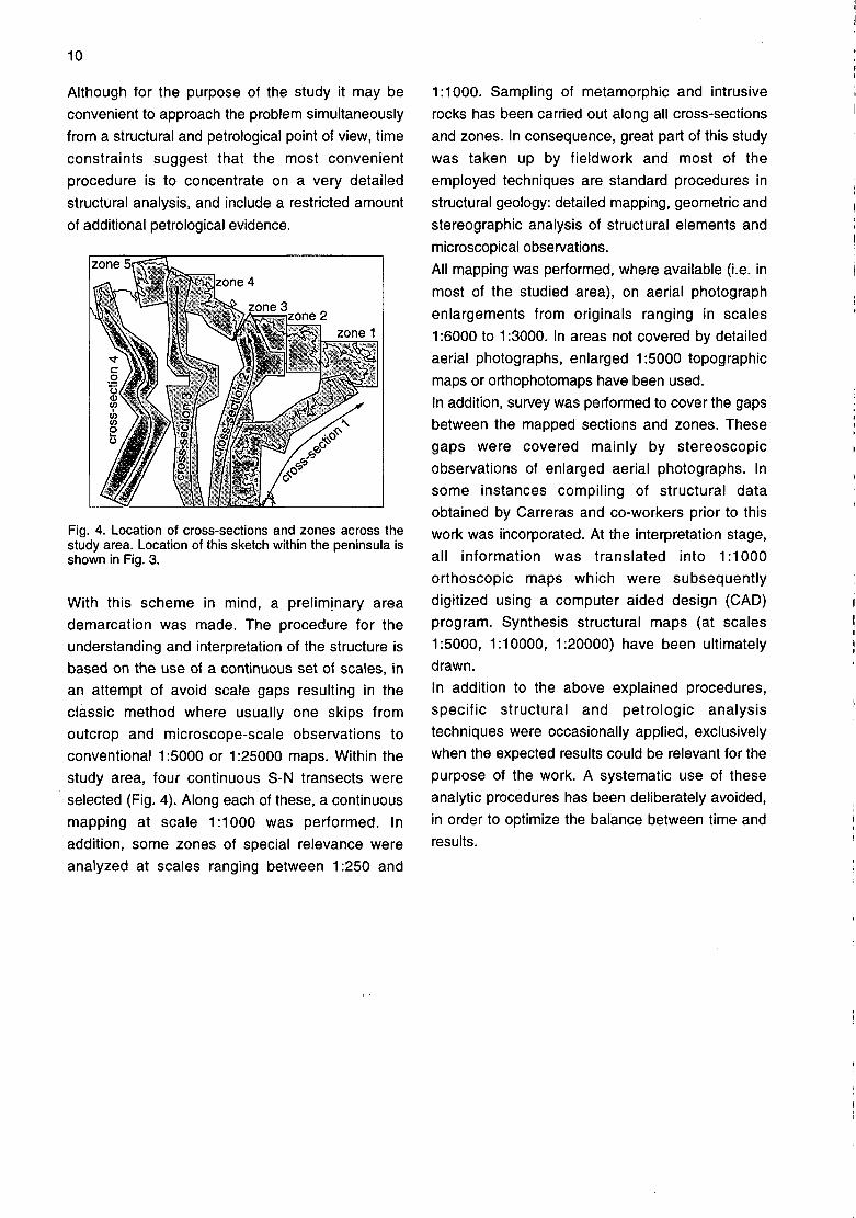
Fig. 4. Location of cross-sections and zones across thestudy area. Location of this sketch within the peninsula isshown in Fig. 3.
With this scheme in mind, a preliminary areademarcation was made. The procedure for theunderstanding and interpretation of the structure isbased on the use of a continuous set of scales, inan attempt of avoid scale gaps resulting in theclassic method where usually one skips fromoutcrop and microscope-scale observations toconventional 1:5000 or 1:25000 maps. Within thestudy area, four continuous S-N transects wereselected (Fig. 4). Along each of these, a continuous
mapping at scale 1:1000 was performed. Inaddition, some zones of special relevance were
analyzed at scales ranging between 1:250 and
1:1000. Sampling of metamorphic and intrusive
rocks has been carried out along all cross-sectionsand zones. In consequence, great part of this study
was taken up by fieldwork and most of theemployed techniques are standard procedures instructural geology: detailed mapping, geometric and
stereographic analysis of structural elements and
microscopical observations.
All mapping was performed, where available (i.e. inmost of the studied area), on aerial photographenlargements from originals ranging in scales
1:6000 to 1:3000. In areas not covered by detailed
aerial photographs, enlarged 1:5000 topographicmaps or orthophotomaps have been used.In addition, survey was performed to cover the gapsbetween the mapped sections and zones. These
gaps were covered mainly by stereoscopicobservations of enlarged aerial photographs. Insome instances compiling of structural dataobtained by Carreras and co-workers prior to thiswork was incorporated. At the interpretation stage,all information was translated into 1:1000orthoscopic maps which were subsequentlydigitized using a computer aided design (CAD)program. Synthesis structural maps (at scales1:5000, 1:10000, 1:20000) have been ultimatelydrawn.
In addition to the above explained procedures,specific structural and petrologic analysistechniques were occasionally applied, exclusivelywhen the expected results could be relevant for thepurpose of the work. A systematic use of theseanalytic procedures has been deliberately avoided,in order to optimize the balance between time andresults.

2 GEOLOGICAL SETTING

13
Rocks outcropping in the Cap de Creus peninsula
belong to four main lithological categories: 1) the
sedimentary sequence, 2) pre-Hercynian magmatic
rocks emplaced in (1), 3) Hercynian deep seated
intrusives emplaced in medium and high grade
metasediments and 4) Hercynian granitoids
emplaced in shallow low or very low grade
metasediments. In the Cap de Creus peninsula,
rocks corresponding to the deepest structural levels
outcrop along the northern part of the peninsula and
belong to categories 1, 2 and 3. (Fig. 3).
The sedimentary sequence and the pre-Hercynian
magmatic rocks constitute two originally different
sets of rocks, both affected by Hercynian
deformations and metamorphism, giving rise to the
metasedimentary series and the interlayered
metaigneous rocks. These rocks form a schist belt
with higher grade terms located along domains
close to the northern seashore of the peninsula.
2.1. THE METASEDIMENTARY SEQUENCE ANDOTHER LITHOLOGIES
The metasedimentary sequenceThe inetasedimentary sequence in the study area
consists of a thick and rather monotonous
succession of alternating metapsammites and
metapelites rocks. The lower and thickest part of the
succession is a monotonous alternance of
predominant metagreywackes, minor metapelites
and scarce lithological differentiable intercalations,
which is named the Cadaqués Series (Carreras and
Losantes, unpublished), also referred to as the
Cadaqués-Cap de Creus Series (Carreras &
Ramírez 1984). Towards upper stratigraphie levels,
the metasediments become gradually darker and
more pelitic, until they form a well distinguishable
unit of black schists with minor marble lenses, which
are known as the Montjoi Series, after a locality in
the SE of the Cap de Creus peninsula. This Series
is represented in the study area by pelitic black
schists outcropping in Muntanya Negra (Fig. 5). The
ensemble including Cadaqués and Montjoi Series
forms the Lower Series in the Cap de Creus area.
In the Cap de Creus peninsula, these Lower Series
are unconformably covered by a siliciclastic-
carbonate series, known as the Upper or Norfeu
Series, outcropping essentially in the south-eastern
corner of the Peninsula and along a NW-SE
trending band bounding the Roses and Rodes
granodiorite massifs.
In the study area, the Cadaqués Series (Fig. 6a)
consist of an alternance of metagreywackes
(usually a few tens centimetres thick) and thinner
metapelites. However, in some areas (e.g. eastern
coast of Cala Culip, western coast of Cala Pórtalo,
Puig de Cala Sardina) massive greywacke beds up
to 10 meters thick with minor pelitic interlayers form
the dominant lithology.
The colour of these rocks varies between ochre-
grey (the most psammitic layers) and eaden grey
(the most pelitic), although colour may change in
function of the metamorphic grade. Occasionally, an
original or mimetic graded bedding is recognizable
(Fig. 6b). The discontinuous character of bedding
and the monotony of the series hinder the use of
greywacke beds as mapping tracers.
Most abundant interbedded layers in this
metasedimentary sequence are plagioclase-
amphibole rocks (Fig. 6c). These form
discontinuous millimetric to decimetric layers, andare spatially related to greywacke-rich parts of the
sequence. They are especially abundant and thick
(up to 80 cm) in the Culip-Lighthouse area. They
usually display lensoid and sub-concordant
geometries with the enclosing metasediments, and
sometimes graded layering with greywackes.
Discontinuity of these lenses is in part the result of
tectonic boudinage, but in a few places, lenses that
apparently crosscut bedding have also been
observed. These rocks bear strong analogies with
intercalations in the Villalba series (Capdevila 1969,
Bard et al. 1972) or with some amphibolites
associated to the "Olio de Sapo" gneisses (Navidad
1978), in the Central Iberian Zone.
Apart of these thin plagioclase-amphibole layers,
two main intercalated units have been recognized in
the Lower Series, namely a quartzite unit and a
lithologically complex unit made of variable rock
types, with black schists and calc-silicate rocks as
the most representative (Fig. 5).
The quartzites form distinct layers whose thickness
range between a few centimetres and a few meters.
They are well banded and may appear either
predominantly dark (named Rabassers quartzite) or
predominantly light coloured (named Culip
quartzite). Types with similar proportion of dark and

14
light-coloured internal bands are also common. Thebest outcrops of the Rabassers quartzite arelocated close to Mas Rabassers de Dalt, where it is
made of metric-scale beds of black and whitestriped fine grained quartzites. (Fig. 6d). The darker
streaks are due to abundant carbonaceous material.The Culip quartzites (Fig. 6e), also called white
quartzites in this work, are lighter and coarsergrained than the Rabassers type.
The other mentioned lithological intercalation,appearing sporadically within the sequence, isheterogeneous in both thickness and composition. Ithas been called Sant Baldiri complex (Ramirez1983a) and it is mainly made of black schists(carbon-rich metasediments), calc-silicate rocks,
marbles, white quartzites, leucogneisses, andamphibolites (Fig. 6f). In the area this complex isbest developed in La Birba zone, surrounding thePort de la Selva gneiss, described below. Rustyschists are usually present adjacent to the rocks ofthe Sant Baldiri complex.The Rabassers and Culip quartzites, together withthe Sant Baldiri complex, are the only traceablemarker beds in the area. However, as it will beexplained below, there is evidence against the SantBaldiri complex being a primary intercalation in thesedimentary series.
The pre-Hercynian igneous intercalationsTwo main types of pre-Hercynian igneous rocks arepresent in the area: gneisses and metabasites
(Navidad & Carreras 1995). The gneissescorrespond predominantly to the Port de la Selvagneiss and to some thin lenses of leucocraticgneisses included in the Sant Baldiri complex. Themetabasites form discontinuous bodies located atdifferent positions within the Cadaqués Series andthey are also found as thin lenses within the SantBaldiri complex.
The Port de la Selva gneisses form a continuous E-W trending sheet-like body, the eastern closure ofwhich outcrops in the study area (Fig. 5). It is
granitic to quartz-monzonitic in composition
(Ramirez 1983a, Carreras and Ramirez 1984), with
relict porphyric texture and sporadic feldsparphenocrysts. It has an intrusive character in theCadaqués series.
Metabasic rocks form several bodies. The largestones are those of the northern slopes of Muntanya
Negra and at the Puig Alt Petit summit (Fig. 5) andhave been named after these two localities. Other
outcrops occur in the vicinity of the mentioned ones.They were originally gabbro-dolerite intrusions, nowforming lens-shaped bodies which have beentransformed into greenschists and amphibolites due
to Hercynian metamorphism. In low-straineddomains, metagabbros are texturally heterogeneouswith pegmatoid differentiates, and display diablasticor lepido-nematoblastic textures with relict diabasictextures allowing to identify them as orthotype rocks(probably subvolcanics). In the western slopes ofMuntanya Negra, outside of the study area, somemetabasalts with identical geochemistry to themetagabbros have been identified (Navidad &Carreras 1995), indicating the comtemporaneity ofthis magmatic event and the sedimentation of theCadaqués Series. In a similar way, the REEpatterns of the plagioclase-amphibole intercalationsand the metabasites are analogous, suggesting thatall these rocks have a similar origin, the plagioclase-amphibole rocks bearing partly a sedimentary andpartly an igneous character.
According to Navidad and Carreras (1995), basicand acid magmatic events, although overlapped intime, have no genetic connection, since the formerhave crustal origin and the latter derive from themantle.

. 5: PRE-HERCYNIAN ROCKSNE CAP DE CREUS PENINSULA
\
/ mo S.f«^ de C-sl
CN\
rx-
pul, F.rr.l
-C A D A 9 U É S
1 km
scale: 120000
1 black eucogneisses _;;I schists calc-ahcats rocks r^
black schists^Imartjles mar
l(C:Cullptype, R: Rabassers type)
Iplagioclase-amphibole rocksi ! I metagreywackes
Jandmetapelltes
i 1 Port de la Selvaí I í gneisses
-BHmelabasltes

17
Fig. 6: Field photographs, (a) Metasediments of the Cadaqués Series, close to Cadaqués village, (b) Mimetic gradedbedding in metasediments at Puig de Culip, showing younging direction to the right (East), (c) Plagioclase-amphibolerocks at Puig de Culip. (d) Black and white striped quartzites (Rabassers type) at Mas Rabassers de Dalt. (e) Lightquartzites (Culip type) at Puig de Culip. (f) Rocks of the Sant Baldiri complex in S'Alqueria. 1: black schists, 2:leucogneisses, 3: marbles.

18
Interpretation, correlation and possible agesIn the Pyrenees, the basement stratigraphy is
relatively well established for rocks of Upper
Ordovician (Caradoc-Asghill) or younger ages, but
little is known about the stratigraphy of lower series.
These lower unfossiliferous series are habitually
named "the Cambro-Ordovician". The origin of such
naming is due to Cavet (1957), who considered, by
analogy to the Montaigne Noire massif, that the
series" along the northern side of the Canigó massif,
in spite of lack of fossils, could be correctable with
the well dated Cambrian and Ordovician rocks of
the Montaigne Noire massif. Although conclusive
dating is lacking, ages older than Cambrian were
not considered, due to the interpretation that these
series were unconformabily covering a Cadomian
granite basement of 580+20 Ma age (Vitrac-Michard
& Allègre 1975 a, b).
Because of the analogy of the Cap de Creus series
with other series occupying similar positions in other
Pyrenean areas, these have been generally
included in the Cambro-Ordovician. However, the
lack of conclusive evidence concerning their
stratigraphie position is the reason why in some
works the black slates (Montjoi Series) and the
overlying calcareous-siliciclastic layers (Norfeu
Series) have been tentatively attributed either to the
upper Ordovician (Carreras, 1979) orto the Silurian-Devonian (Carreras 1979).
Nowadays, the age and position of the Series in the
Cap de Creus peninsula is still an enigma, however,
two tentative correlations have been proposed (Fig.
7). On one hand, in Laumonier's contributions to the
Pyrenean synthesis and other works (Laumonier &
Guitard 1978, Laumonier 1988 and BRGM-ITGE
1997). The Cadaqués Series are correlated with the
Canavelles Series of Cavet (1957), while the
Montjoi and Norfeu Series are considered to be
equivalent to respectively the lower and Upper part
of the'Cabrils formation of Laumonier (1988).
An alternative correlation is defended by Carreras
(1988 & pers. comm.), in which the Cap de Creus
rocks are considered to occupy a lower stratigraphie
position than the above mentioned, and even lower
than the Canavelles type series. This idea is based
on the assumption that the Pyrenean orthogneiss
series.l"dó not represent the basement of the
sedimentary series and hence the sequences which
are now found overlying the gneisses might
continue downwards. In such interpretation (Fig. 7),
the Cadaqués Series could be correctable to the
greywacke series of Balaig in the Canigó massif
and to the schists of the Roc de Frausa, while the
Montjoi Series might be an equivalent of the dark
pelitic series with interlayered marbles of
Canavelles s. str. (i.e. the sequences close to
Canavelles village). In this scheme, the Norfeu
series could correlate with the Evol formation of
Laumonier (1988) northof the Canigó. If these
correlations and assumed Cambrian ages for the
Canavelles formation (Laumonier 1988) were
.correct, the Cap de Creus series could be lower
Cambrian or even upper Proterozoic in age.
Apart of the dating and correlation problems, there
is an additional question of relevance to the Cap de
Creus geology. This refers to the origin of the Sant
Baldiri complex. There are strong arguments
suggesting that this unit is rather a tectonic
emplaced slice than a primary intercalation (see
chapter .4, section 2.1). Although the age of the
emplacement will be described later, one can put
forward that mapping of the whole peninsula
evidences the continuity between (i) the Norfeu and
Montjoi Series in the SE, and (ii) the black series
containing marbles, calc-silicate rocks and
quartzites described by Morales (1975) in the NW
(South of Llanca) (Fig. 8). The series at Llançà have
significant analogies with the Sant Baldiri complex
and, furthermore, they also appear pinched in
between psammitic-pelitic alternances.
In the study area, such continuity can not be
demostrated, but anyhow it is manifest that the
black schists of Muntanya Negra (Montjoi Series),
toward the SE closure of the outcrop, become
pinched in between the Cadaqués series forming
narrow stripes of black schists similar to those
attributed to the Sant Baldiri complex further North.
Thus, the black schists of the Sant Baldiri complex
could match the Montjoi Series and the calc-silicate
rocks and marbles could match the carbonate base
of the upper series or the carbonates in the Monjoi
Series. The unusual association of lithofacies of the
Sant Baldiri complex, the irregularity with which
each different lithology is present in each outcrop
and the tectonic contacts with the adjacent
metasediments, suggest also the proposed
correlation.

19
A recent Rb/Sr datation of the Port de la Selva
gneiss gives an age of 375 ± 51 ma (Navidad, pers.
comm.). This age calls into question the possibility
of the Port de la Selva magmatism being
synchronous with sedimentation of the lower
Palaeozoic sequences.
CONFLENTLaumonier Carreras
UPPER CABRILSSERIES
LOWER CABRILSSERIES
CANAVELLESSERIES
EVOLSERIES
CANAVELLESSERIES(s. str.)
BALAIGSCHISTS
CAP DE CREUS
NORFEUSERIES
CADAQUÉSSERIES
Fig. 7: Stratigraphie sketch of the Cap de Creus series and suggested correlations with the Conflent (E-Pyrenees)series. RQ: Rabassers quartzite; M.M.: Montjoi marbles; P: metaporphyres; N.M.1: lower Norfeu marbles; C:conglomerates; S: sandstones; N.M.2: upper Norfeu marbles; D.M.: dolomite marbles.
MEDITERRANEAN SEA
Montjoi & Norfeu Series
see Fig. 3 for other symbols
CADAQUÉ
S. Baldiri complex in Cadaqués Series
Fig. 8: Map showing three different settings of the slices of dark schists ± calc-silicate rocks. While in localities LL (SLlançà) and MN (Muntanya Negra) these slices belong to Montjoi series (and Norfeu series), in locality SB (Sant Baldiri),a slice with similar lithologies was considered as a primary intercalation. It is suggested that the Sant Baldiri complexrepresents also tectonic slices and thus cannot be used as a stratigraphie marker.

20
2.2. TECTONIC SETTING
The structure in the northern Cap de Creus area is
complex and characterized by polyphase tectonics,
with at least two main deformation events'during the
prograde metamorphic episode and late folding and
shearing events in retrograde conditions. Although
individual deformation phases are easily recognized
in a given outcrop, their correlation from one domain
to the other is a rather arduous task. Main
difficulties arise from the following facts:
1) Each deformation phase produces structures that
vary significantly in style and orientation from one
domain to the other. These variations are due to
strain inhomogeneities, changes in properties of the
deforming rocks and differences in thermal
conditions during deformation.
2) Most structures appear to have developed as a
result of a progressive deformation, without a clear
cut from one phase to the next.
3) There is a lack of manifest large scale structures
correctable with widespread minor structures. This
is due to the absence of markers and to thedominating deformation style.
In outline, the following structural features are most
characteristic to the Cap de Creus Massif. The
overall structure in map view is characterized by a
predominant trend of structures ranging between E-
W to NW-SE (Fig. 9), although folds with variable
axial traces exist. This structural orientation is
essentially the result of folds affecting ubiquitous
penetrative foliations, but also results from the effect
of shear zone-related mylonite belts, which cut
across the previous folded foliations and also
across the Hercynian intrusives. These shear zones
show similar orientations to the above mentioned
folds. Folds affecting an early foliation have a south
vergence, with axial planes being subhorizontal on
the south-eastern part of the peninsula but
becoming inclined towards the Northwest. In a NE-
SW section of the peninsula, structures of the NE
side show moderate to steep NE dips, while on the
SW part of the section, moderate to subhorizontal\ • . . ^ ° • . K r I •
SE dips of prevalent foliations and axial planes
dominate. This change in attitude is caused by the
existence of a gentle fold that caused the doming of
all pre-existing structures. Axes of all mappable fold
structures have predominantly SE plunges,
although in the NE part of the peninsula they
acquire gradually E, NE and even N orientations.
The above mentioned structural arrangement is
' considered to be the responsible for the distribution
of different tectonic'and lithostratigraphic levels of
the Cap de Creus peninsula., Shallow. levels
consisting of Upper Series of very low metamorphic
grade outcrop mainly on the SE corner of the
peninsula and along a NW-SE trending zone
bounding the Roses and Rodes granodiorites. On
the other hand, deeper seated structural levels,
consisting of the medium to high grade Cadaqués
Series, are located along the northern side of the
Peninsula. In Carreras (1975), a WNW-ESE
synformal structure, located on the northern part of
the Peninsula, was considered to be responsible for
the distribution of the metamorphic zones, as
metamorphism increased northwards across the
steep limb of the synform (Fig. 10). In fact, as it will
be presented later, this structure is far more
complex than described in that work.
A remarkable structural feature is the variation in
tectonic style through different domains, depending
on the achieved metamorphic grade. While low
grade metasediments deformed continuously in the
same tectonic style, giving rise to folds with
associated axial plane foliations, medium to high
grade domains deformed in a highly ductility regime
during episodes close to the metamorphic peak and
developed anastomosed shear zones in later
retrograde events (coarse grained schists,
developed by previous recrystallization and grain
growth, where unable to nucleate folds). These
differences in tectonic style lead Carreras & Casas
(1987) to distinguish in the northern part of the
peninsula three zones: a northern shear belt, a
southern fold belt and a transition zone in between
where the folds and the shear zones coexisted. The
existence of such changes in tectonic style through
different domains is not exclusively the result of
different behaviour of deforming rocks during late
episodes. Moreover, differences in tectonic style
arose also during earlier deformation events1- as
result of strain inhomogeneities and 'differences in
the thermal conditions.