the story of blawhorn moss national nature · pdf filethe story of blawhorn moss national...
TRANSCRIPT

The Story of Blawhorn
Moss National Nature
Reserve


The Story of Blawhorn Moss National Nature Reserve Foreword Blawhorn Moss National Nature Reserve (NNR) is the largest and least disturbed lowland raised mire or bog in the Lothians. It is situated in the hills northwest of Blackridge, west of Armadale. Peatland was once common in Central Scotland but very little remains today, most bogs being cut for peat, drained for farming or planted for forestry. This makes remaining areas, such as Blawhorn Moss, very important. Blawhorn Moss is one of 56 NNRs in Scotland. NNRs are special places, carefully managed to conserve some of the best examples of Scotland’s wildlife and habitats. While nature always comes first on NNRs, they also provide opportunities for people to enjoy and find out about the richness of our natural heritage. This Reserve Story provides background information on the Reserve and its management history. It briefly describes the habitats and wildlife found on the Reserve; why they are special in UK and European terms; the history of land use and management of wildlife, people and property on the Reserve, up to the present day. The Reserve Proposals outline how it is proposed to manage the Reserve in future years; comments are invited on the Proposals and will be used to inform the Reserve Plan. This is the blueprint for management of the Reserve for a six-year period. At the end of the Plan period, a Reserve Review is used to report how well our plans have worked. These documents can be downloaded from the Scotland’s NNRs website (www.nnr-scotland.org.uk) or obtained from the address below. For further information about Blawhorn Moss National Nature Reserve please contact: Scottish Natural Heritage, Laundry House, Dalkeith Country Park, Dalkeith, Midlothian, EH22 2NA Tel: 0131 654 2466 Fax: 0131 654 2477 Email: dalkeith@ snh.gov.uk

The Story of Blawhorn Moss National Nature Reserve
Contents
Foreword i
Maps of Blawhorn Moss NNR iii
1 Introduction to Blawhorn Moss NNR 1
2 The Natural Heritage of Blawhorn Moss NNR 3
3 Management of Blawhorn Moss Before it Became a NNR 7
4 The Management of Blawhorn Moss NNR 8
Appendix 1 – National Nature Reserves (NNR) 17
Appendix 2 – Special Areas of Conservation (SAC) 19
Appendix 3 – Sites Of Special Scientific Interest (SSSI) 22
ii

The Story of Blawhorn Moss National Nature Reserve
Maps of Blawhorn Moss NNR Location maps
Boundary of Blawhorn Moss
iii

The Story of Blawhorn Moss National Nature Reserve
1 Introduction to Blawhorn Moss NNR A large part of Blawhorn Moss, some 69 hectares (ha), has been owned and managed as an NNR by Scottish Natural Heritage (SNH) and its predecessors since 1980. In 2001, SNH purchased a further 40.43 ha of the eastern part of the Moss. Tin 2008 this was declared as an extension to the existing NNR. The Reserve is located northwest of the village of Blackridge, 4 miles west of Armadale in Central Scotland. It can easily be reached by heading north off Junction 4 of the Edinburgh – Glasgow M8 motorway. Blawhorn Moss is one of the larger expanses of active raised bog in Central Scotland that has remained relatively undisturbed. It is protected as a site of both UK and European importance. The main conservation designation in the UK is the Site of Special Scientific Interest (SSSI). Blawhorn Moss was notified as an SSSI on the basis of being the largest and least disturbed peatland in the Lothians. Appendix 3 contains a map and description of the SSSI. The European network of protected areas is called Natura 2000; the network contains sites with habitats and species of European importance. The protected areas are classified as either a Special Area of Conservation (SAC) for the protection of habitats and species or, if for the protection of birds, a Special Protection Area (SPA). Blawhorn Moss was confirmed as a Special Area of Conservation in 2005. Appendix 2 contains details of the SAC designation. Table 1: Designations and qualifying features of Blawhorn Moss NNR Designation Special Area of
Conservation Site of Special
Scientific Interest West Lothian Biodiversity Action Plan
Feature European UK Local
Active raised bogs Degraded raised bogs still capable of natural regeneration
Raised bog Peat bogs
There has been a dramatic decline in the area of raised bog habitat in Europe since the start of the nineteenth century. The decline has been such that ‘active raised bog’ is a priority habitat for inclusion in the Natura 2000 network. The UK, along with Finland, Sweden and Ireland, has many large raised bogs and therefore has a particular responsibility for conserving them. In the UK, there are 55 active raised bogs with SAC status; nearly half of these sites are in Scotland.
1

The Story of Blawhorn Moss National Nature Reserve
In the UK, very few active raised bogs remain undamaged. As has happened in Central Scotland, most have been affected by activities like peat cutting, forestry or draining for farmland. The selection of SACs has therefore included ‘degraded raised bogs still capable of natural regeneration’ as well as ‘active raised bogs’. Blawhorn Moss is a site with both active and degraded raised bog.
2

The Story of Blawhorn Moss National Nature Reserve
2 The Natural Heritage of Blawhorn Moss NNR Geology and Geomorphology Blawhorn Moss lies at 220 metres above sea level in a slight depression. The depth of peat across the site varies but can be up to 8 metres. The peat surface is slightly domed but merges into a more typical blanket mire topography on the north-eastern side. Hydrologically, it has developed around a linear east-west mineral ridge. To the north of the ridge the peatland drains northwards into the Drumtassie Burn, while to the south of the ridge the peatland drains southward into the Barbauchlaw Burn. The western section of the site is divided from the eastern section for the most part by a deep ditch draining into the Drumtassie burn. The underlying solid geology is of the Upper Carboniferous Productive Coal Measures of the Palaeozoic era, aged at approx 290 million years. Overlying the solid geology are areas of boulder clay deposited by glacial activity during the Pleistocene. The most obvious evidence of the glacial activity is the mineral strip, which partly bisects the southern part of the site. Habitats The main natural heritage interest of Blawhorn Moss is the extensive area of raised and blanket bog and, where it still exists, the supporting lagg fen system at the edges of the bog. The vegetation exhibits well-developed hummock and hollow topography, and supports many of the plant species representative of bog habitat. The area of peatland at Blawhorn Moss accounts for 2% of the total raised bog resource in Great Britain and 0.2% of the EU total raised bog area1. It is the largest (109.43 ha) and least disturbed lowland raised bog in Lothian and one of the larger raised bogs in the Central Belt of Scotland. It supports the 3rd largest area of primary natural surface in the central belt of Scotland. The peatland at Blawhorn Moss exhibits characteristics of both raised and blanket bogs. Much of the site supports primary raised bog habitat, which is undisturbed by peat cutting, agriculture or forestry, although over large areas its topography and vegetation are more characteristic of blanket bog. The important factor is that there is continued active growth of bog mosses, sphagnum species on the bog surface. The bog habitats at Blawhorn Moss are described as raised and blanket bog communities with cross-leaved heath and Sphagnum papillosum being key species. This is the characteristic vegetation of rain-fed peatlands in moderately oceanic parts of lowland Britain. The variations across the site are a reflection of the extent of
1 The National Peatland Resource Inventory Database
3
The Story of Blawhorn Moss National Nature Reserve
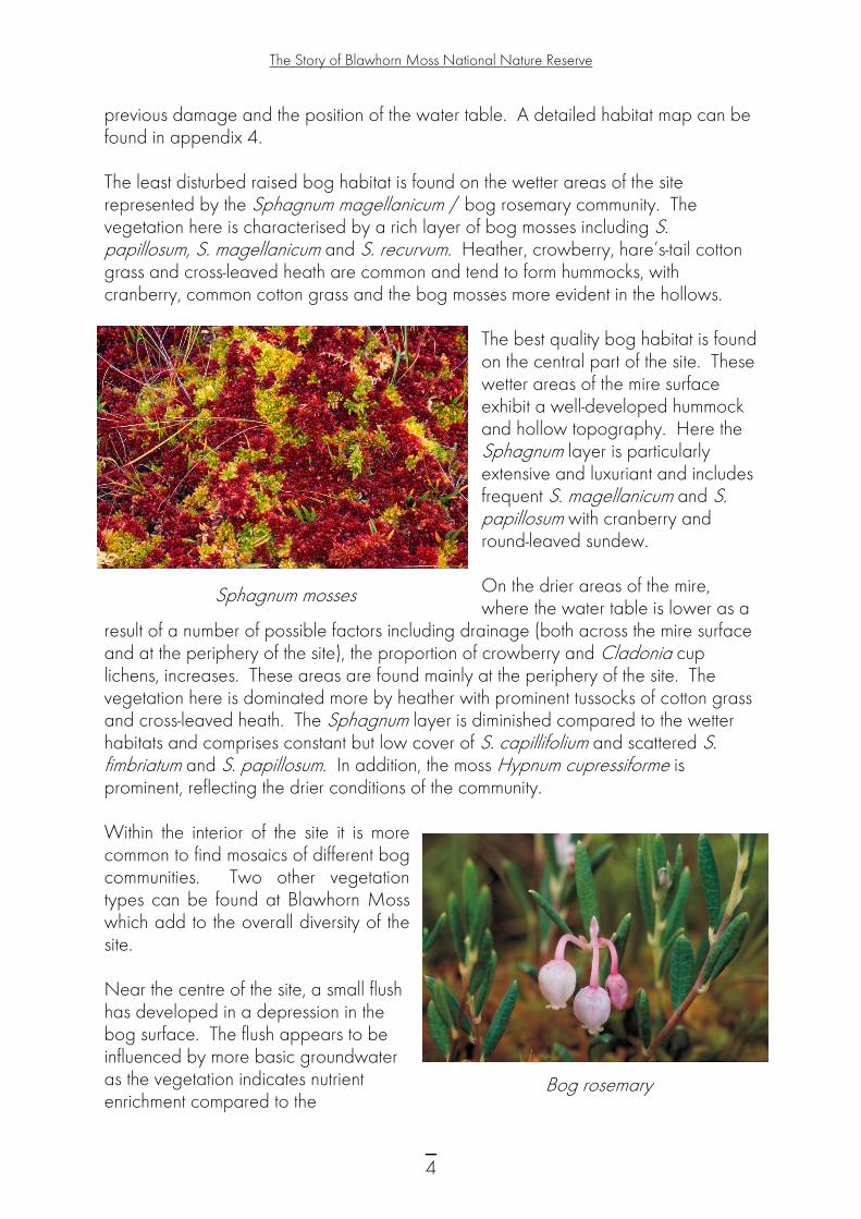
previous damage and the position of the water table. A detailed habitat map can be found in appendix 4. The least disturbed raised bog habitat is found on the wetter areas of the site represented by the Sphagnum magellanicum / bog rosemary community. The vegetation here is characterised by a rich layer of bog mosses including S. papillosum, S. magellanicum and S. recurvum. Heather, crowberry, hare’s-tail cotton grass and cross-leaved heath are common and tend to form hummocks, with cranberry, common cotton grass and the bog mosses more evident in the hollows.
The best quality bog habitat is found on the central part of the site. These wetter areas of the mire surface exhibit a well-developed hummock and hollow topography. Here the Sphagnum layer is particularly extensive and luxuriant and includes frequent S. magellanicum and S. papillosum with cranberry and round-leaved sundew. On the drier areas of the mire, where the water table is lower as a
result of a number of possible factors including drainage (both across the mire surface and at the periphery of the site), the proportion of crowberry and Cladonia cup lichens, increases. These areas are found mainly at the periphery of the site. The vegetation here is dominated more by heather with prominent tussocks of cotton grass and cross-leaved heath. The Sphagnum layer is diminished compared to the wetter habitats and comprises constant but low cover of S. capillifolium and scattered S. fimbriatum and S. papillosum. In addition, the moss Hypnum cupressiforme is prominent, reflecting the drier conditions of the community.
Sphagnum mosses
Within the interior of the site it is more common to find mosaics of different bog communities. Two other vegetation types can be found at Blawhorn Moss which add to the overall diversity of the site. Near the centre of the site, a small flush has developed in a depression in the bog surface. The flush appears to be influenced by more basic groundwater as the vegetation indicates nutrient enrichment compared to the
Bog rosemary
4
The Story of Blawhorn Moss National Nature Reserve
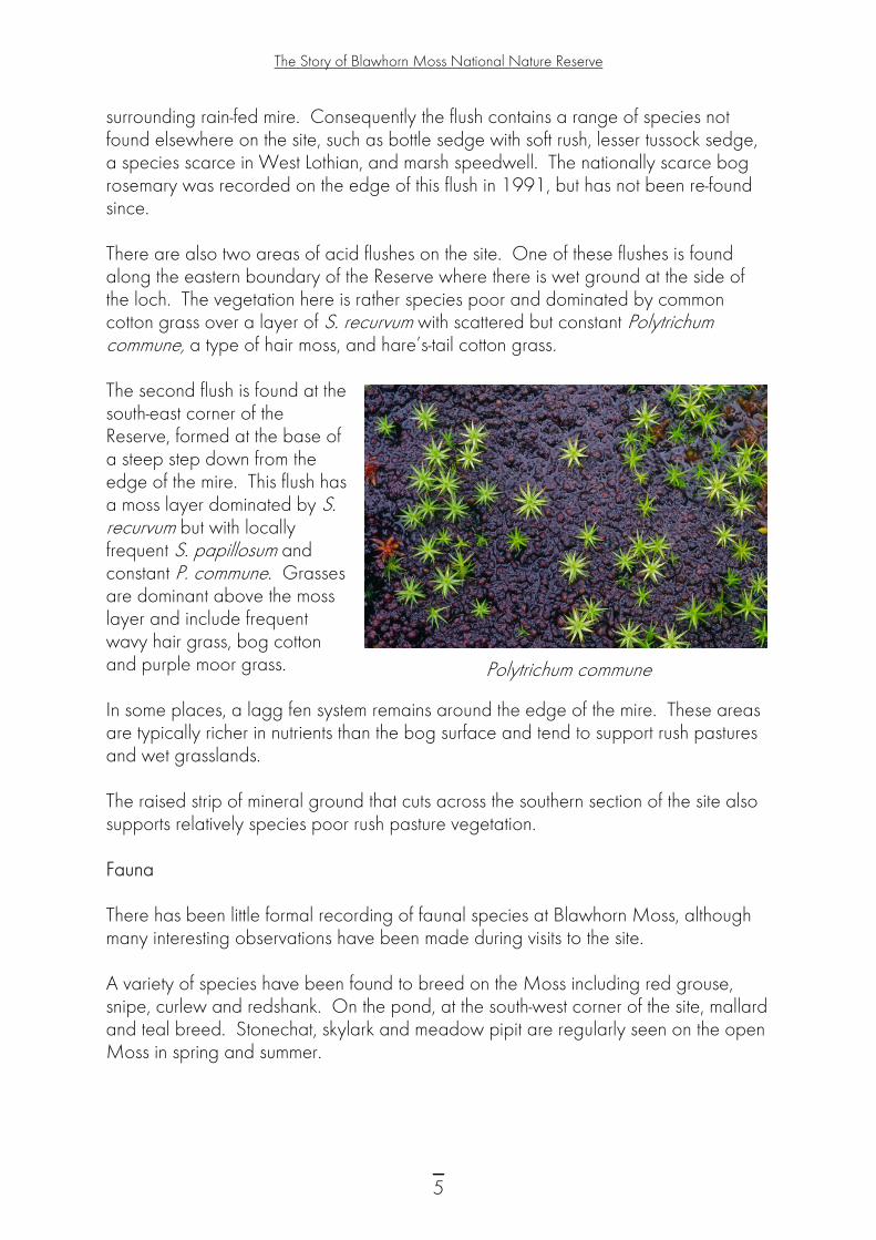
surrounding rain-fed mire. Consequently the flush contains a range of species not found elsewhere on the site, such as bottle sedge with soft rush, lesser tussock sedge, a species scarce in West Lothian, and marsh speedwell. The nationally scarce bog rosemary was recorded on the edge of this flush in 1991, but has not been re-found since. There are also two areas of acid flushes on the site. One of these flushes is found along the eastern boundary of the Reserve where there is wet ground at the side of the loch. The vegetation here is rather species poor and dominated by common cotton grass over a layer of S. recurvum with scattered but constant Polytrichum commune, a type of hair moss, and hare’s-tail cotton grass. The second flush is found at the south-east corner of the Reserve, formed at the base of a steep step down from the edge of the mire. This flush has a moss layer dominated by S. recurvum but with locally frequent S. papillosum and constant P. commune. Grasses are dominant above the moss layer and include frequent wavy hair grass, bog cotton and purple moor grass. Polytrichum commune In some places, a lagg fen system remains around the edge of the mire. These areas are typically richer in nutrients than the bog surface and tend to support rush pastures and wet grasslands. The raised strip of mineral ground that cuts across the southern section of the site also supports relatively species poor rush pasture vegetation. Fauna There has been little formal recording of faunal species at Blawhorn Moss, although many interesting observations have been made during visits to the site. A variety of species have been found to breed on the Moss including red grouse, snipe, curlew and redshank. On the pond, at the south-west corner of the site, mallard and teal breed. Stonechat, skylark and meadow pipit are regularly seen on the open Moss in spring and summer.
5
The Story of Blawhorn Moss National Nature Reserve
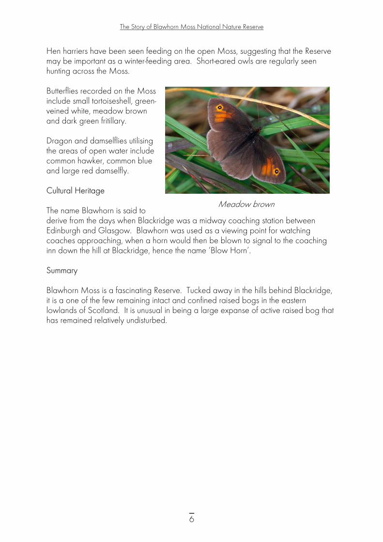
Hen harriers have been seen feeding on the open Moss, suggesting that the Reserve may be important as a winter-feeding area. Short-eared owls are regularly seen hunting across the Moss. Butterflies recorded on the Moss include small tortoiseshell, green-veined white, meadow brown and dark green fritillary. Dragon and damselflies utilising the areas of open water include common hawker, common blue and large red damselfly. Cultural Heritage The name Blawhorn is said to derive from the days when Blackridge was a midway coaching station between Edinburgh and Glasgow. Blawhorn was used as a viewing point for watching coaches approaching, when a horn would then be blown to signal to the coaching inn down the hill at Blackridge, hence the name ‘Blow Horn’.
Meadow brown
Summary Blawhorn Moss is a fascinating Reserve. Tucked away in the hills behind Blackridge, it is a one of the few remaining intact and confined raised bogs in the eastern lowlands of Scotland. It is unusual in being a large expanse of active raised bog that has remained relatively undisturbed.
6

The Story of Blawhorn Moss National Nature Reserve
3 Land use at Blawhorn Moss There is little documented history about the early management or land use of the Moss. The 1860 Ordnance Survey map shows the farm of Little Drumbeg on the mineral strip. At this time, the mineral strip was clearly cultivated, indicated by old rig and furrow and a number of enclosures. It is likely that the Moss itself was grazed extensively by sheep and cattle. Traditional land use practices, such as burning to improve the nutritional value of the vegetation for stock, may also have taken place at Blawhorn Moss. On the south-eastern edge of the Moss there is evidence of peat cutting which would probably have been for local fuel supplies. At some time in the late 1940s, the whole surface of the Moss was drained and most of the perimeter lined by ditches. The extensive system of drainage ditches are still visible, particularly on the western section. The ditches were cut approx 45 cm in section and spaced about 10 metres apart across the Moss. Presumably this was an attempt to intensify its agricultural use. Shortly after this time, ownership of the western part of the site passed to the National Coal Board Open Cast Executive (NCB). Although much of the surrounding area was mined as part of the Whiteside Opencast mine, the Moss itself remained untouched. On 15 November 1979, after nearly a decade of interest by the Nature Conservancy Council (NCC), ownership of the western section of the site was transferred from the NCB to NCC for the nominal sum of £10.
7
The Story of Blawhorn Moss National Nature Reserve
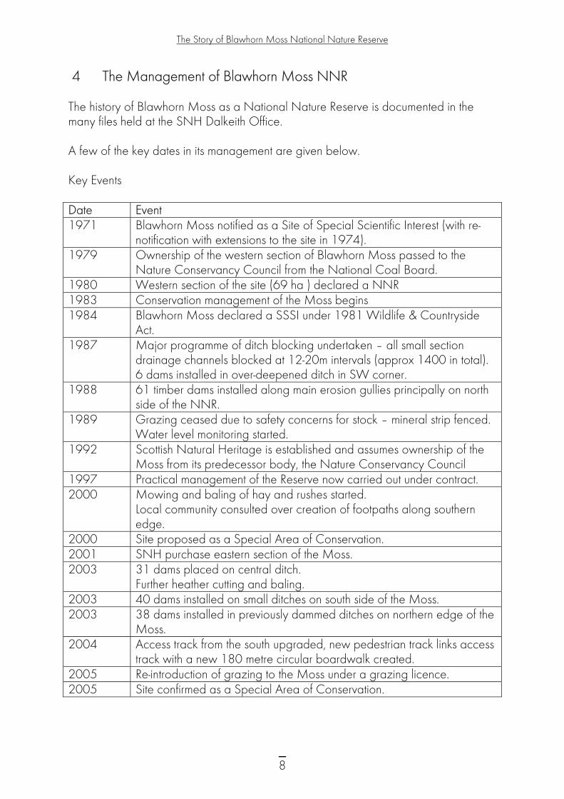
4 The Management of Blawhorn Moss NNR The history of Blawhorn Moss as a National Nature Reserve is documented in the many files held at the SNH Dalkeith Office. A few of the key dates in its management are given below. Key Events Date Event 1971 Blawhorn Moss notified as a Site of Special Scientific Interest (with re-
notification with extensions to the site in 1974). 1979 Ownership of the western section of Blawhorn Moss passed to the
Nature Conservancy Council from the National Coal Board. 1980 Western section of the site (69 ha ) declared a NNR 1983 Conservation management of the Moss begins 1984 Blawhorn Moss declared a SSSI under 1981 Wildlife & Countryside
Act. 1987 Major programme of ditch blocking undertaken – all small section
drainage channels blocked at 12-20m intervals (approx 1400 in total). 6 dams installed in over-deepened ditch in SW corner.
1988 61 timber dams installed along main erosion gullies principally on north side of the NNR.
1989
Grazing ceased due to safety concerns for stock – mineral strip fenced. Water level monitoring started.
1992 Scottish Natural Heritage is established and assumes ownership of the Moss from its predecessor body, the Nature Conservancy Council
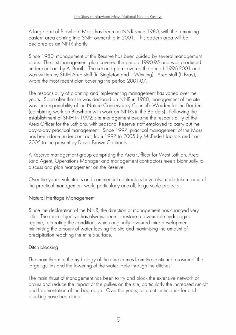
1997 Practical management of the Reserve now carried out under contract. 2000 Mowing and baling of hay and rushes started.
Local community consulted over creation of footpaths along southern edge.
2000 Site proposed as a Special Area of Conservation. 2001 SNH purchase eastern section of the Moss. 2003 31 dams placed on central ditch.
Further heather cutting and baling. 2003 40 dams installed on small ditches on south side of the Moss. 2003 38 dams installed in previously dammed ditches on northern edge of the
Moss. 2004 Access track from the south upgraded, new pedestrian track links access
track with a new 180 metre circular boardwalk created. 2005 Re-introduction of grazing to the Moss under a grazing licence. 2005 Site confirmed as a Special Area of Conservation.
8
The Story of Blawhorn Moss National Nature Reserve
A large part of Blawhorn Moss has been an NNR since 1980, with the remaining eastern area coming into SNH ownership in 2001. This eastern area will be declared as an NNR shortly. Since 1980, management of the Reserve has been guided by several management plans. The first management plan covered the period 1990-95 and was produced under contract by A. Booth. The second plan covered the period 1996-2001 and was written by SNH Area staff (R. Singleton and J. Winning). Area staff (I. Bray), wrote the most recent plan covering the period 2001-07. The responsibility of planning and implementing management has varied over the years. Soon after the site was declared an NNR in 1980, management of the site was the responsibility of the Nature Conservancy Council’s Warden for the Borders (combining work on Blawhorn with work on NNRs in the Borders). Following the establishment of SNH in 1992, site management became the responsibility of the Area Officer for the Lothians, with seasonal Reserve staff employed to carry out the day-to-day practical management. Since 1997, practical management of the Moss has been done under contract, from 1997 to 2005 by McBride Habitats and from 2005 to the present by David Brown Contracts. A Reserve management group comprising the Area Officer for West Lothian, Area Land Agent, Operations Manager and management contractors meets biannually to discuss and plan management on the Reserve. Over the years, volunteers and commercial contractors have also undertaken some of the practical management work, particularly one-off, large scale projects. Natural Heritage Management Since the declaration of the NNR, the direction of management has changed very little. The main objective has always been to restore a favourable hydrological regime, recreating the conditions which originally favoured mire development, minimising the amount of water leaving the site and maximising the amount of precipitation reaching the mire’s surface. Ditch blocking The main threat to the hydrology of the mire comes from the continued erosion of the larger gullies and the lowering of the water table through the ditches. The main thrust of management has been to try and block the extensive network of drains and reduce the impact of the gullies on the site, particularly the increased run-off and fragmentation of the bog edge. Over the years, different techniques for ditch blocking have been tried.
9
The Story of Blawhorn Moss National Nature Reserve
The first trials for ditch blocking started in 1984, when two surface drains were in-filled with peat sods. The drains retained some water upslope but there was still considerable leakage. A major programme of ditch blocking took place between 1987 and 1989. All of the small section drainage channels were blocked at 12-20 metre intervals and stepwise up the gradient along their length. One metre corrugated steel sheets, plastic coated on one side and painted on the other, were fitted into cut slots across the drains. We installed over 1000 small dams of this kind, achieving almost total drain blockage with only three drains on the western boundary remaining unblocked. The work was carried out by Reserve staff with Lothian Conservation Volunteers and Scottish Conservation Projects, and completed by a contractor. In 1987, we ran a trial to address gully erosion. This was of concern because of the large amounts of water the dams would impound. We constructed six timber pile dams using elm beams at the southwest corner of the Moss in the over-deepened ditch. Following on from this trial, 61 timber dams were installed the next year on all the main erosion gullies, principally on the north side of the Moss. The above programme worked reasonably well; all the small drainage channels are now water filled with new Sphagnum growth covering some of the sheet dams in the wettest parts. The timber dams have proven effective at preventing ongoing gully erosion.
Using the mini baler to cut heather on Blawhorn Moss NNR
10

The Story of Blawhorn Moss National Nature Reserve
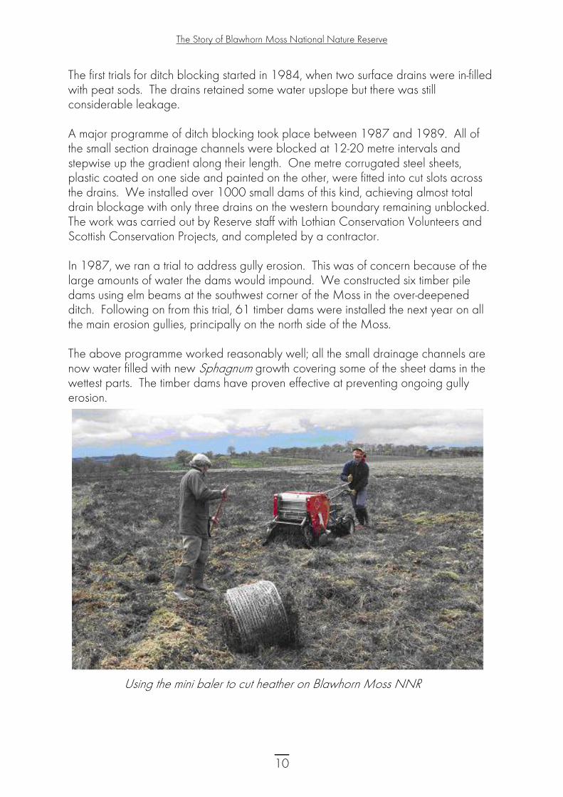
In 2001, an accidental fire spread across 4-5 ha of the Moss, damaging some of the dams on the southern side. These were then replaced with stronger plastic pile dams braced with timber. In 2000, we undertook a project to try mowing and baling heather and rushes for use in ditch blocking. Heather was cut and baled along the northern edge of the site and 1 ha of rush taken from the mineral block. This was undertaken with a ‘CAEB’ mini baler. The following year, over 400 mini bales were placed into ditches on two sections of the Moss near the central flush and northern edge of the Moss. In 2002 and 2003, we undertook further heather cutting and baling and the heather bales were used to backfill existing dams. The heather bales appeared to be effective at slowing down water movement and providing a framework for Sphagnum to grow. The next phase of ditch blocking came in 2003, when 30 large plastic pile dams were built along the central ditch. These dams are successful and hold water well, with depths of 1.5 metres being maintained in the ditches throughout the year. In addition, water levels are raised in the adjacent ground, encouraging the growth of Sphagnum moss. More dams were installed on smaller ditches on the south side of the Moss. The dams were set at a height aimed at raising the water another 15cm above the existing dams. In Dec 2003, 38 further dams were installed in previously dammed ditches on the northern edge of the Moss. They were installed using existing rotten dams for support.
Plastic pile dams on Blawhorn Moss NNR
11

The Story of Blawhorn Moss National Nature Reserve
Tree removal Tree and shrub growth on bogs can result in significant water loss through evapotranspiration (water lost to the atmosphere from the ground surface and plants). At Blawhorn Moss, there is a continuous programme of tree and shrub management, by pulling the smaller saplings and treating larger growth by spraying with an appropriate herbicide. There are now only a small number of trees scattered across the site, with a small pine plantation in the north-west corner and an area of willow carr in the centre of the site. These are closely monitored, and while a limited number of seedlings are removed from the Moss surface each year, the rate of colonisation is not considered to be a threat to the nature conservation interest of the site. Grazing Grazing of the Moss has been intermittent over the years. When the site first became a NNR cattle and sheep grazed the moss. The stock were turned out on the mineral strip and from there had access across onto the bog via broken fences and gates. In 1989, the mineral strip was fenced to exclude stock, as there were outstanding concerns over the safety of the stock given the number of deep drains. The eastern part of the Moss had traditionally been grazed with low numbers of sheep until 2001, when SNH took ownership. In the most south-eastern block, which is part of a wider management unit, the land is grazed with sheep and cattle through a lease with the neighbouring landowner. As grazing of the Moss is important to encourage a wide range of bog plants and insects and reduce the dominance of heather, grazing with sheep was reintroduced in 2005 on the rest of the Moss under a grazing licence to a neighbouring landowner. As has happened in the past, stock access the site from the mineral strip, and from there spread out onto the Moss. A new bridge across the large central ditch allows stock to access the eastern portion of the Moss. Burning There is a history of fire-raising on the Moss - uncontrolled burning as a result of vandalism. In 1980, the whole surface of the Reserve was burnt. Another fire occurred in 1985, and an area along the western margin was burnt in 1990-91. There have also been smaller fires in 2000 and 2001. The recovery of the vegetation from the most recent fires appears to be satisfactory, but the areas affected by fire are noted by a change in vegetation structure. In some areas, where the fire burnt intensely, all sphagnum species have been lost from the Moss surface. These areas are now dominated by a hair moss, P. commune, rather than the bog forming sphagnum mosses. However, in some places some sphagnum mosses have returned after 5 years.
12
The Story of Blawhorn Moss National Nature Reserve
Fires on the Moss continue to be a threat, although it is hoped that the risk of a deep peat burn has been reduced by the increased water levels. Monitoring of the Natural Heritage To help inform and to assess the effectiveness of management, monitoring has always been an important aspect of the work at Blawhorn Moss. Once management work began in 1988, we established a hydrological monitoring programme to record the recovery of water tables within the peat. Two transects of dipwells (Walrags) were installed on the Moss in 1989/90, along with 5 pairs of dipwells spread out across the Reserve. We collected data from the dipwells for a nine-year period and analysed it in 1999. Despite the limitations of the equipment used, important information was gained about water levels relative to the Moss surface and how this varies over time. Monitoring has shown the general trend is an overall rise in water level to the Moss surface, indicating that conditions appear to have become wetter overall. However, there is a general fall in water level relative to the Moss surface, i.e. drier surface conditions at certain locations, indicating the continued influence of the major central ditch. There is also a seasonal water level fluctuation, as would be expected. From 2000 an automatic data logger replaced the manual dipwell recording. As part of SNH’s national programme, we undertook site condition monitoring on the site in 2001. The raised bog feature of the SSSI was classified as being in unfavourable condition for the following reasons;- • Abundance of S. cuspidatum is only rare across the site, whereas for the bog to be
in good condition it should be at least occasional. This may be a result of the biological system taking time to recover, despite the water table being close to the surface of the moss as a result of the management work.
• There are two large active drains in the centre of the site which are still having a significant effect on the hydrology of the site. Future management works will be required to block these large drains.
In 2004, we introduced vegetation monitoring to further assess the impacts of management and the reintroduction of grazing. This involved the establishment of 190 2m x 2m fixed-point quadrats across the site. The results of this work will be available in 2008/09.
13

The Story of Blawhorn Moss National Nature Reserve
Research and Demonstration Since 1980, Blawhorn Moss has been an important site to demonstrate best practice management in restoring the natural hydrology of a raised mire bog. Many of the techniques employed on other peatland sites have been developed from the management works at Blawhorn Moss. In 1996, the International Peatlands Conference held in Edinburgh visited Blawhorn Moss to look at examples of practical restoration techniques. In June 2002, the Scottish Wildlife Trust (SWT) bog team visited the site to look at damming and heather baling work. Blawhorn Moss has not been used extensively for research to date. However, as the Reserve is easily accessible from Glasgow, Edinburgh and Stirling Universities, more research projects will be actively encouraged. Most of the existing research on the site has been work commissioned by SNH or our sister organisation, English Nature (now Natural England). In 1994, Sheffield University looked at the site in relation to damage and rehabilitation. Dundee University looked at the site in relation to the effectiveness of current management techniques in conserving the interest of the peatland SSSI. In 2003, an English Nature project used Blawhorn Moss as one of its study sites, looking at the characterisation of hydrological buffer zones at the margins of designated lowland raised bog sites. These research reports are available from the SNH Dalkeith Office. Management for People People have always been able to visit Blawhorn Moss but in the past it has been a quiet Reserve with limited access and a low profile. This has largely been due to the site’s fragility and susceptibility to damage if large numbers of people visited. In addition, the wet ground and deep ditches have limited accessibility and posed a health and safety risk for those attempting to take access across the Moss. However, in recent years, SNH has put more resources into developing links to the site, in partnership with the local community, and developing a path onto the Moss, making the Reserve an enjoyable and safe place to visit. Visitors Visitors to the Moss are generally local people from the neighbouring village of Blackridge. Occasionally, special interest groups such as the Lothian naturalists or people with an interest in NNRs or raised mires visit the Reserve.
14
The Story of Blawhorn Moss National Nature Reserve
The Reserve is reached from a signed private road leading off the A89 to the west of Blackridge. Originally, the Reserve car park had been located at Drumbeg farm. However, parking in the farmyard was somewhat uninviting for visitors, and we created a new Reserve car park just off the access road in 2006. An access track leads from the car park to the Reserve entrance. In 2004, we upgraded the access track to make it fully accessible and resting points were added. Also in 2004, a new 180 metre circular boardwalk, with a seat and two platforms, was constructed out onto the Moss. A new pedestrian track was put in to link the new boardwalk with the access track to the Reserve. This track is also fully accessible with resting points. In 2002, Blackridge Community Council and Blackridge Access group developed a new local path network with support from SNH. This network includes a path along the southern edge of the Moss, effectively connecting the village of Blackridge with the Reserve. Blawhorn Moss NNR is now featured as part of the Blackridge’s local walks leaflet. Every member of Blackridge village received a copy of the leaflet when it was produced in 2003. There are NNR threshold signs at the entrance to the Reserve. In 2005, two new signs were put in at the car park, with new warning signs informing the public of potential dangers of the mire. There are a number of other signs installed by other organisations at the car park. In 1998, Blawhorn Moss was promoted as part of ‘National Bogs Day’ and a number of guided walks organised around the site were well received. In 2002, we held our first open day on the Reserve. Twenty-six people attended this open day, which included a guided walk around the Moss and exhibitions in the Blackridge community centre. The open days have since developed into more specific school events with pupils from Blackridge Primary School and are held annually. Oatridge College also visit the site as part of their National Vocational Qualification conservation management course. Good links have been established with the local community. This first arose over consultation over the access network and the NNR review, undertaken by SNH in 2002. There is clear pride and support for the NNR from the local community. The honorary warden comes from the village and helps maintain this important community link. In addition to the annual school events, SNH contributes articles about the NNR to the community newsletter. This is an area we are hoping to develop further in the coming years.
15

The Story of Blawhorn Moss National Nature Reserve
In 2003, a leaflet was produced for Blawhorn Moss as part of SNH’s NNR series. The leaflet for Blawhorn Moss is quite unique in that it is based on artwork from the 2003 P7 class at Blackridge Primary School. To help guide future developments, an interpretation strategy was commissioned and produced in March 2004 in consultation with the residents of Blackridge. Blawhorn is promoted on the SNH NNR web page: www.nnr-scotland.org.uk Management of the Property SNH now own and manage all the land in the Reserve, although the mineral rights over the western section remain with Scottish Coal. There is a vehicle right of access along the track to the east of the site leading to the new car park which is also leased. There is a pedestrian right of access along the track to the east of the site to the point on the eastern boundary. Fences mark the boundary of the Reserve. The visitor infrastructure – the car park, paths, boardwalks and signs - are all regularly checked and maintained as part of the Reserve management contract. Conclusion Blawhorn Moss NNR has a rich natural heritage which is recognised by European and national designations. Restoration management over the last 25 years has aimed to repair the damage to the site caused by extensive drainage in the 1940s and enhance the quality of the important raised mire habitats. Local people use the Reserve and significant improvements have been made to visitor facilities. Links have been established with the local community of Blackridge and a successful open day is organised each year for Blackridge Primary School. This document introduces Blawhorn Moss National Nature Reserve. We hope that you have enjoyed finding out more about this special place; if you can add to our knowledge or understanding, please let us know.
16

The Story of Blawhorn Moss National Nature Reserve
Appendix 1 – National Nature Reserves (NNR) Scotland's National Nature Reserves are special places for nature, where many of the best examples of Scotland’s natural heritage are protected. Nature comes first on our NNRs (referred to as primacy of nature). These Reserves also offer special opportunities for people to enjoy and find out about the richness of our natural heritage. National Nature Reserves (NNRs) are declared under the National Parks and Access to the Countryside Act 1949 or the Wildlife and Countryside Act 1981. A new policy for National Nature Reserves in Scotland was developed in 1996. This policy requires NNRs in Scotland to have four attributes, and to be managed for one or more of the three purposes. The attributes are:
• Primacy of nature. The needs of nature will be placed at the heart of decisions about land use and management of our NNRs, and nature conservation will be the overriding land use, although it may not be the sole purpose of management.
• National importance. It must be of national importance that the NNR be managed as a nature reserve, for the protection of geological features, habitats or species found there.
• Best practice management. NNRs must be well managed, not only to safeguard the nature conservation interests, but also to provide for people’s enjoyment and understanding.
• Continuity of management. Both research and management on NNRs require us to take a long-term view, so it is important that management continuity is assured.
The purposes are:
• National awareness of NNRs – on these reserves people can take pride in the natural heritage ‘on display’ and come to understand it better and enjoy it to the full.
• Specialised management of NNRs - the character of the interest requires specialised and proactive management that is best delivered by a nature reserve.
• Research-related NNRs - These NNRs will offer opportunities for research into the natural heritage and its management that specifically require a nature reserve location and which are not available elsewhere.
Between 2000 – 2003, all of Scotland’s National Nature Reserves were reviewed against this policy. As a result of the review there are now 55 National Nature Reserves in Scotland.
17

The Story of Blawhorn Moss National Nature Reserve
More information can be found at: National Nature Reserves http://www.nnr-scotland.org.uk Scotland’s National Nature Reserves: A policy statement http://www.snh.org.uk/pdfs/polstat/nnrpolcy.pdf
18

The Story of Blawhorn Moss National Nature Reserve
Appendix 2 – Special Areas of Conservation (SAC) Special Areas of Conservation are areas designated under the European Community Council Directive on the Conservation of Natural Habitats and Wild Fauna and Flora (92/43/EEC), commonly known as the Habitats Directive. Together with Special Protection Areas, which are designated under the Wild Birds Directive for wild birds and their habitats, SACs form the Natura 2000 network of sites. The Natura 2000 network is designed to conserve natural habitats and species of animals and plants which are rare, endangered or vulnerable in the European Community. Appendixes I and II of the Habitats Directive list the habitats and (non-bird) species respectively for which SACs are selected. In Great Britain the Directive was transposed into domestic legislation via the Conservation (Natural Habitats &c.) Regulations 1994, which are relevant to Special Protection Areas (SPAs) as well as SACs. Natura sites are generally underpinned by the SSSI mechanism in the terrestrial environment, although there are a few exceptions where other management measures are employed. The Scottish Executive Rural Affairs Department Circular No. 6/1995 (Revised June 2000) on the Habitats and Birds Directives gives further details of how the Regulations apply in Scotland. SNH acts as the advisor to Government in proposing selected sites for ministerial approval as possible SACs. SNH then consults with key parties over the site proposals on behalf of Scottish Ministers. The consultees, who include owners and occupiers of land, local authorities and other interested parties, are sent details of the proposed site boundaries and the habitats and/or species for which they qualify. SNH also negotiates the longer-term management of these sites. Following consultation, SNH forwards all responses to Scottish Ministers who then make a decision about whether to submit the site to the European Commission as a candidate SAC. Once submission of all candidate sites is completed, the Commission, together with Member States, will consider the site series across Europe as a whole. At this stage sites which are adopted by the Commission become Sites of Community Importance (SCIs), after which they can be finally designated as Special Areas of Conservation by national governments. The following websites provide further information: Special Areas of Conservation: http://www.jncc.gov.uk/ProtectedSites/SACselection
19

The Story of Blawhorn Moss National Nature Reserve
Blawhorn Moss SAC
Country Unitary Authority Grid Ref* Latitude Longitude SAC EU code Status Area (ha)
Scotland West Lothian NS885682 55 53 40 N 03 47 00 W UK0019758 Designated Special Area of Conservation (SAC) 109
* This is the approximate central point of the SAC. In the case of large, linear or composite sites, this may not represent the location where a feature occurs within the SAC.
General site character Bogs. Marshes. Water fringed vegetation. Fens (92.7%) Humid grassland. Mesophile grassland (7.3%)
Blawhorn Moss SAC Boundary
20

The Story of Blawhorn Moss National Nature Reserve
Boundary map and associated biodiversity information on the NBN Gateway. Natura 2000 data form for this site as submitted to Europe (PDF format, size 30kb). Annex I habitats that are a primary reason for selection of this site Active raised bogs * Priority feature Blawhorn Moss is one of the larger, least-disturbed Active raised bogs in the central belt of Scotland. The vegetation exhibits well-developed hummock and hollow topography and supports many of the species representative of bog, such as Sphagnum papillosum, S. magellanicum and cranberry Vaccinium oxycoccus. It is of further interest in that on one side it grades into 7130 Blanket bogs.
Annex I habitats present as a qualifying feature, but not a primary reason for selection of this site Degraded raised bogs still capable of natural regeneration
21

The Story of Blawhorn Moss National Nature Reserve
Appendix 3 – Sites Of Special Scientific Interest (SSSI) Scottish Natural Heritage is the key statutory agency in Scotland for advising Government and for acting as the Government’s agent in the delivery of conservation designations in Scotland. Site of Special Scientific Interest (SSSI) is the main nature conservation designation in Great Britain. These sites are special for their plants or animals or habitats, their rocks or landforms or a combination of these. The SSSI series has been developed over the last 50 years, and since 1981 as the national suite of sites providing statutory protection for the best examples of GB’s flora, fauna, or geological or physiographical features. Originally notified under the National Parks and Access to the Countryside Act 1949, many SSSIs were renotified and others newly notified under the Wildlife and Countryside Act 1981 or the Nature Conservation (Scotland) Act 2004. Further changes in the protective mechanisms were introduced by the 2004 Act. These sites are also used to underpin other national and international nature conservation designations. Most SSSIs are privately owned or managed; others are owned or managed by public bodies or non-government organisations. There are more than 1400 SSSIs in Scotland. Web Links: ‘The Nature of Scotland – A Policy Statement’ http://www.scotland.gov.uk/library3/environment/nas-00.asp 'People And Nature: A New Approach To SSSI Designations In Scotland' http://www.scotland.gov.uk/library/documents-w1/pandn-00.htm Guidelines for Selection of Biological SSSIs http://www.jncc.gov.uk/Publications/sssi/default.htm Site of Special Scientific Interest (SSSI): http://www.snh.org.uk/about/ab-pa01.asp
22
The Story of Blawhorn Moss National Nature Reserve
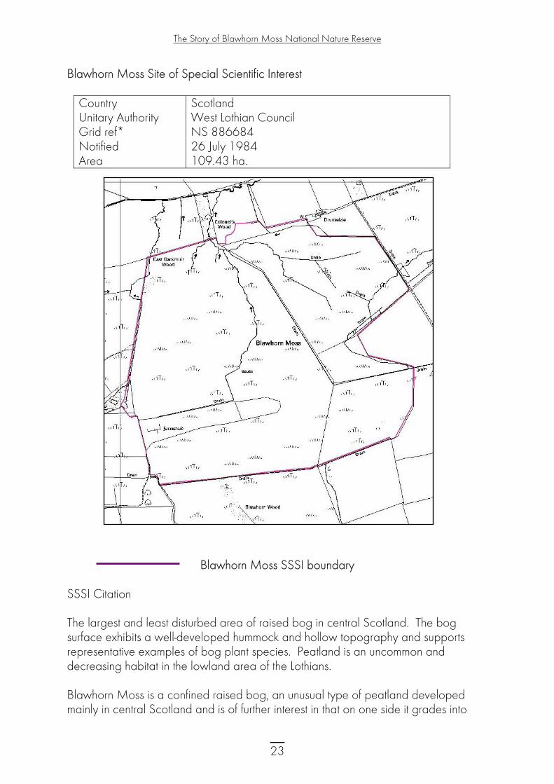
Blawhorn Moss Site of Special Scientific Interest
Country Unitary Authority Grid ref* Notified Area
Scotland West Lothian Council NS 886684 26 July 1984 109.43 ha.
Blawhorn Moss SSSI boundary
SSSI Citation The largest and least disturbed area of raised bog in central Scotland. The bog surface exhibits a well-developed hummock and hollow topography and supports representative examples of bog plant species. Peatland is an uncommon and decreasing habitat in the lowland area of the Lothians. Blawhorn Moss is a confined raised bog, an unusual type of peatland developed mainly in central Scotland and is of further interest in that on one side it grades into
23

The Story of Blawhorn Moss National Nature Reserve
blanket bog, although this is not a notified feature of the site. The present vegetation of Blawhorn Moss and the resultant communities are representative of a composite of raised and blanket bog conditions. Although much of the site supports primary raised bog habitat, over large areas the topography and vegetation communities suggest that it may be more appropriately described as primary blanket bog. The open raised bog vegetation is especially sphagnum rich, with short heather and blaeberry. A small flush near the centre contains a range of species not found elsewhere on the site and includes lesser tussock sedge, bog pondweed and marsh speedwell. NOTIFICATION HISTORY First notified under the 1949 Act: 1 January 1971. Re-notified under the 1981 Act: 26 July 1984 with a 17.64ha decrease in area. Notification reviewed under the Nature Conservation (Scotland) Act 2004: 02 April 2008. REMARKS Measured area of site corrected (from 109.43ha). The SSSI is contiguous with Blawhorn Moss Special Area of Conservation (SAC) for the European Habitats listed below. Habitats: Active raised bog Degraded raised bog
24

The Story of Blawhorn Moss National Nature Reserve
Appendix 4 – National Vegetation Classification of Blawhorn Moss The National Vegetation Classification (NVC) is one of the key common standards developed for the country nature conservation agencies. The original project aimed to produce a comprehensive classification and description of the plant communities of Britain, each systematically named and arranged and with standardised descriptions for each. For more information on the NVC see the Joint Nature Conservation Committee website: http://www.jncc.gov.uk/page-4259
NVC Type Description CA/M23b wet grassland M6a mire M18b raised mire M18a raised mire M23b rush pasture M25b mire MG10a rush pasture S9a/M23b swamp/rush pasture
25