the story of a stream
TRANSCRIPT

1
Green’s Cave Sullivan, Mo.
The story of a stream...
REVISED—2003 Updates on River and Place Names Origins,
Plus Meramec River Source.
2
Table of Contents Page #
Note From Author Preface 3
Quotes (Nature) 3
A Special Place! -update- Introduction
Map -update- Names Origins
4 5 6
Its Story! The Genesis The Evolution The Transition
Enter Man The Paleo Indians
The Archaic Indians The Woodland Indians
The Mississippians The Historic Indians
Civilization and Commerce Quiz Yourself
Early Settlement The Iron Era
7 9
12 14 14 15 17 18 20 23 24 25 26
What It Has To Offer You Now! A Playground For All Do’s and Don’ts How To Canoe
Upper Meramec Map Significant Tributaries Statistical Information
33 35 36 37 38 44
How To Come Enjoy It! Sponsors 51
Trip Recorder 61
Endnotes Photo Album
64 65
For Edith & Alex
The Meramec River: Then and Now. 2003 Revised Edition by William R. Kammer
“The following text is a brief historical survey of the Meramec River. Comprised of general descriptions of the major evolutionary events which have occurred and features existing past and present - in the area of the Meramec Valley. It includes a description of geological formation; the river itself; past wildlife and human inhabitants; settlement and utilization; current conditions; guidelines to present usages (includes rules, regulations and safety tips); and a listing of some of the area’s best river service providers.”
Some River & Cave Photo’s by: Delores Page, On Cover: Karin Barger & Andy Harbert (Greens Cave), John Barger (in canoe).
Special thanks to: Professor Lawrence Christensen & Professor Larry Vonalt, University of Missouri, Rolla.

3
Preface First, I must offer a special thanks to all the wonderful floaters of whom over the years I have had the pleasure to meet, and for whom I have had the privilege of playing a part in their enjoyment of the Meramec river. Witnessing their appreciation of the river has had a profound and eternal effect on my own appreciation of this wonderful stream, and played an instrumental role in my motivation to research and produce this text. My feelings of appreciation and concern for our depleting natural environment have been reinforced through my experiences as a canoe liveryman, but their origins go much deeper into my personal history. On introspection of my past I find images lurking in my memory, of boyhood, and long walks along the bank of the Mighty Mississippi near St. Louis. As I inspect the images, I see pictures of drainpipes of every size and description pouring unknown substances of every color, texture, and odor imaginable into the river, and snapshots of huge sewer-pipes gushing raw sewage continuously and relentlessly into the mix. There are morose likenesses of floating, bloated fish bodies littering the banks and collecting in the quiet coves and backwaters. Some with bizarre looking growths and sores on them, some looking contorted as though they died by a most unpleasant tortured means. There are also other images, of my parents and I on long drives through the country-side, searching for and finding crystal clear country springs and streams, beautiful forgotten farm ponds, and lost lakes deep in the woods - all teaming with life and natures’ beauty. These experiences form the foundation for my respect and admiration of our natural world earth, and also provide me with a first-hand knowledge of how fragile the balance of nature truly is, and defenseless against the consummate greed and exploitation of man . The condition of the Upper Meramec can still (for the most part) be considered pristine, and though some laws designed to protect the natural habitat have been enacted, this stream is not immune to the threats of *industry, *development, or *exploitative and *inconsiderate usage. If the production and distribution of this booklet serves (in any way) to raise awareness and increase the likelihood that this precious stream will be more seriously respected, protected and preserved, I will consider it a glorious success. *Mining is the most serious industrial threat to the Meramec at this time (see page 43 ‘land use’). *The most serious threat from increased development of lands near the Meramec is due to private landowner dump-sites. Hazardous materials from sites miles away will most likely still make its way to the river if the sites are within the river’s drainage area or the recharge area of a spring which feeds into the river. It occurrs through run-off, losing streams which feed springs, and seepage into the water table. *Exploitative and Inconsiderate Usage = trash & litter, large herds of watering livestock degrading banks (increasing erosion) and increasing algae levels.
Nature ? The tree which moves some to tears of joy is in
the eyes of others only a green thing that stands in the way. Some see nature all ridicule and deformity … and some scarce see nature at all. But to the eyes of the man of imagination, nature is imagination itself. William Blake (1757–1827), English poet, painter, engraver. Letter, 23 Aug. 1799 (published in The Letters of William Blake, 1956).
? As long as I retain my feeling and my passion for Nature, I can partly soften or subdue my other passions and resist or endure those of others. Lord Byron (1788–1824), English poet. Letter, 10 June 1822, to author Isaac D’Israeli (published in Byron’s Letters and Journals, vol. 9, ed. by Leslie A. Marchand, 1979).
? After you have exhausted what there is in business, politics, conviviality, and so on—have found that none of these finally satisfy, or permanently wear—what remains? Nature remains. Walt Whitman (1819–92), U.S. poet. Specimen Days and Collect, “New Themes Entered Upon” (1882).
? I know no subject more elevating, more amazing, more ready to the poetical enthusiasm, the philosophical reflection, and the moral sentiment than the works of nature. Where can we meet such variety, such beauty, such magnificence? James Thomson (1700–1748), Scottish poet. The Seasons, Preface. The poem’s novel attitude toward nature anticipated the Romantic movement.
? The best remedy for those who are afraid, lonely or unhappy is to go outside, somewhere where they can be quiet, alone with the heavens, nature and God. Because only then does one feel that all is as it should be and that God wishes to see people happy, amidst the simple beauty of nature. As long as this exists, and it certainly always will, I know that then there will always be comfort for every sorrow, whatever the circumstances may be. And I firmly believe that nature brings solace in all troubles. Anne Frank (1929–45), German Jewish refugee, diarist. The Diary of a Young Girl (1947; tr. 1952), entry for 23 Feb. 1944.
All the above quotes are courtesy of The Columbia Dictionary of Quotations. Columbia University Press (1993). Microsoft Bookshelf ‘95

4
Introduction
About fifteen miles Southeast of the town of Salem in Southeastern Missouri, near the junction of Dent County Roads 559 & 560, a spring-fed brook begins its journey North. Before long, the brook merges with the ‘Dry Branch’ (on the right), ‘Wofford Branch’ and ‘Carty Branch’ (both on the left) and becomes the source of the Meramec River. For many millions of years the Meramec has been carving its twisting, sometimes tortuous 240 mile course into the solid rock of the Ozark Plateau, scouring its way through a deep, slowly widening valley, bordered by limestone bluffs and steep hills. It is joined along the way by innumerable springs, creeks, and four large tributaries, which transform the Meramec into a one hundred yard - to two hundred yard wide flood plane stream at its confluence with the Mighty Mississippi eighteen miles below St. Louis.1
Maramec spring (note the spelling) is the first of the four major contributors, it pours an average volume of one hundred million gallons of cold clear water into the Meramec per day, swelling the river to twice its size. It is interesting to note that the Dry Fork, which is
...A RIVER IS FIRST AND FOREMOST A PIPELINE, A MOVING BODY OF WATER IN THE PLUMBING OF OUR PLANET, AS INTEGRAL TO THE CYCLE OF LIFE ON EARTH AS THE OCEAN WHICH RECEIVES IT, AND THE SOIL IT DRAINS. A RIVER IS AN ARTERY OF CONNECTION BETWEEN INLAND AREAS, OCEANS, AND OTHER BODIES OF
LAND AND WATER, AND ALSO A LIVING ECOSYSTEM, PROVIDING SUSTENANCE TO INNUMERABLE CREATURES WHO LIVE ALONG ITS’ BANKS AND IN ITS’ WATERS. HISTORY
IS SAID TO FLOW AND TAKE ITS COURSE, AS A RIVER DOES, AND THROUGHOUT HISTORY THE RIVERS HAVE MEANT MANY DIFFERENT THINGS TO MANY DIFFERENT
PEOPLE, IN COUNTLESS DIFFERENT WAYS AND EVENTS....
about the same size as the Meramec in that area, loses most of its volume underground to become a major contributor to Maramec Spring, and in a round-about way - a major contributor to the Upper Meramec. Over the next thirty miles, the inflows from many smaller branches turn the river into a prime stream. Then, from the right, the translucent waters of the second and largest of the headwater contributors, the Courtois--(pronounced code-away)--Huzzah creek, mingles with the Meramec, giving it the impression of a truly big river. Swirling on past Onondaga Cave (Leasburg), Meramec State Park (Sullivan), and the Meramec Caverns (Stanton)--all on the left-- the Meramec receives the cloudy waters of the Bourbeuse River--its’ only major contributor from the west. As the darker waters flow on, the valley widens, and the river becomes “a series of long, slow, wide pools, connected by short, fast, riffles.” Around twenty-five miles below the Bourbeuse River confluence, the last major contributor, the Big River, flows into the Meramec from the right. Now, even wider and more sluggish, it enters the Mississippi flood-plain, and wends its way another thirty miles before draining into the Mississippi.2

5
A Special Place! Mississippi R.
Missouri R.
St. Louis
Meramec R.
Big R.
Bourbeuse R.
Courtois Creek
Huzzah Creek
Meramec R. Dry Fork
Maramec Spring
Steelville
Cuba
Bourbon
Sullivan * Meramec State Park
Onandaga Cave
Meramec Caverns
Union
Leasburg
Salem
Pacific

6
Also, the title of this state Missouri is of Miami-Illinois origin, from the Miami-Illinois Indians' name for the Siouan—speaking tribe known as the Missouri Indians. The term "Missouri" comes from weemihsoorita, meaning “one who canoes,” “one who has a canoe”. 45
-SPECIAL THANKS TO MICHAEL MCCAFFERTY-
Even in geological time, the Meramec is a very old river. It does not drain its northeastern section of the Ozark Plateau with the reckless abandon of a mountain stream. Instead, it meanders through the landscape in a countless succession of bends, riffles, and placid slow stretches, each of which is another small step in the Meramecs’ eight hundred foot decent from the Ozark Plateau to the Mississippi River.4 There is no need for a special knowledge of the past to enjoy the Meramec. The natural beauty of the landscape along its banks provides most travelers with a deep appreciation. It evokes in me a special feeling of connection with my primordial past. A past in which our ancient ancestors prospered and gave birth to civilization around rivers, and whose lives were inextricably linked to the streams, for many thousands of years. I believe that out of that relationship has evolved a deep, basic affinity for the picturesque, natural setting of a river such as the Meramec. That is not to say however, that an understanding of how this river and its features came to be is in any way the least bit detrimental to enjoying the experience of it. Indeed, to me, knowing the story of the Meramec has enhanced my appreciation of its character and features and also increased my spiritual feelings of ancient links and natural existence. It is the great age of this river that creates the splendor and allure of its setting. To understand how it got this way, we must go way back in time, to the geological formation of the under-pinnings of the entire region of the Ozark Plateau.
The name “Meramec” is of Algonquian Indian origin, and means “ugly fish” or “catfish”, which were abundant in its waters, however, it is possible that the river is named after a band of Miami-Illinois (Inoka) Indians. According to Michael Mccafferty, Algonquian linguist specialist in the Miami-Illinois language and expert in Algonquian place names/river names in the Midwest. “The river is noted and its name is given in the dictionary prepared by the Jesuit missionary Antoine-Robert Le Boullenger. The name in the Miami-Illinois language is myaarameekwa 'catfish'. Myaar(a) means 'ugly' and meekwa means 'fish'. (the double-e is what is termed a "long vowel" in Algonquian, and is pronounced like the ai of 'rail'.)” Also according to Mccafferty, that name was given the Meramec for one of two possible reasons: “1) Actually, it *is* possible that this stream did indeed have an noticeable abundance of catfish. This may seem unlikely, but we do know for certain that other streams, for example the Tippecanoe and the Eel rivers of Indiana, were each named after a kind a fish that lived in their respective waters in outstanding abundance (the first is the name for buffalo fish, a species of carp). In Miami-Illinois the term is kiteepihkwana. or 2) it was named after a band of Indians known as the "catfish".” and “It is not impossible that myaarameekwa was the name of a Miami band, since we see in history references to "the Miami of Meramec". Or it just may be that this group of Miami were living on the Meramec River.” 44
The name of the Mississippi is also of Algonquian origin, derived from their term mihsisiipi, meaning ‘Big River’.

7
The Genesis The Ozark Mountains form a 50,000 square mile dissected plateau which lies chiefly in southern Missouri, but partly in Arkansas, Oklahoma, and Kansas. The 3980 square mile Meramec Basin lies at the northeastern tip of the plateau, and forms a watershed which runs generally northeast into the Mississippi valley. Five hundred million years ago, before forces beneath the earth's crust pushed the Ozark Plateau up into existence, it was part of the bottom of a huge shallow warm sea. Over millions of years, sediments accumulated on that ocean bottom, and minerals within the sediments and the sea water combined to create huge beds of calcium magnesium carbonate. With the passing of time and the pressure of successive layers of sediment, the beds solidified into stone.5 Most of the rock is white dolomite limestone, but trapped within the beds were gelatinous blobs of silicon dioxide which, when compressed, became the extremely hard chert rock from which the Indians fashioned their spear and arrow heads. Also, scattered throughout the formations were sand-like deposits which became sandstone. Some time around four hundred million years ago, forces beneath the earth’s crust repeatedly pushed up and resubmerged the area of the bedrock that
became the Ozark Plateau. A process of great erosion and resedimentation occurred, which is sometimes evident in the visible divisions or layers in the exposed rock bluffs interspersed
along the Meramecs’ course. Those scenic bluffs, composed mostly of dolomite, are the result of millions of years of erosion, and the abrasive action of sand and mud in the Meramec’s waters cutting through the rock like a sort of "liquid sandpaper." Since dolomite is softer than chert and more susceptible to the dissolving action of water, the gravel-bars below the bluffs usually contain higher concentrations of chert than normally exist in the rock beds, because much of the dolomite has been washed away.6
The Story Of The Meramec!

8
Ammonite: extinct 65 million years.
Within the rocks appear the ancient fossil graveyards which tell geologists the story of the elevations and resubmergence of the plateau. Like pages in a history text, each layer of sediment bears the remains of the creatures that existed at that time. They provide the clues needed to suggest when that particular layer of sediment was deposited. The best place to see this geological record is around the rim of the basin because the wind and water erosion that occurred from successive uplifts washed away much of the record in the Meramec valley, suggesting the large scale scouring that took place. The river itself was undoubtedly an instrumental force in etching away much of the record of millions of years of the development of its valley. The winding path of the Meramec is a result of the gradual uplifts of the plateau, which, rather than forcing the river to carve a straight headlong rush down the valley, allowed it to take its meandering course. The slow rises in the terrain were not abrupt enough to force the river to deviate drastically from its course, but did however, slowly increase the force of its fall with each small uplift, causing the river to dig a deeper and deeper trough in the rock. The many distinctive caves which exist in the Meramec Basin were once gushing springs, and are also a by-product of the uplifts. Beneath the soil, the porous dolomitic bedrock acted like a huge sponge, soaking up the mildly acidic water which seeped through the layers of soil above. Over long periods of time, the water etched and dissolved cavities in the softer portions of the rock, and the cavities expanded and connected to become springs. In reality, springs are part of the plumbing in a massive water collection and redistribution process. Hydrostatic pressure from the moisture in the soil above pushes the water down through the rock cavities, which channel it
back up to the nearest opening to the surface like an "upturned faucet,”7 creating the cold, crystal clear springs so common to the Meramec Valley. Maramec Spring, which is the largest to join the Meramec, has an average flow of almost 100 million gallons per day, and in a series of five successful dye trace studies was shown to gain its volume from a recharge area of approximatly 310 square miles. The numerous caves which permeate the Meramec Basin are also a part of the vast deep plumbing system, and due to the uplift of the entire area, were raised above the hydrostatic pressure level, to become open air cavities. The loss of much of the soil above the caves through erosion reduced the pressure from above, and reduced the volume of the seepage waters that caused them. It is hard to imagine that the famous massive caves of the area, such as Meramec Caverns and Onondaga Cave, were once huge flowing pipelines, but indeed they were. At that time, there were none of the wondrous, awe inspiring formations found in the caves today, for these occur during the declining final stages of a caves’ life. As the water seeping into the cave from above loses some of its carbon dioxide content into the caves’ atmosphere, it becomes less acidic, which allows previously dissolved minerals in the water to crystallize. Slowly, relentlessly, the mineral formations, and minute particles of soil seeping through from above fills the cavities, in a sort of reversal of the process that formed them. Beneath the surface of the Meramec Valley is a virtual honeycomb of flowing, silted up, or hollow cavities, of which new ones are discovered regularly, and any well driller can attest to.8
Trilobite: extinct 300 million years.
9
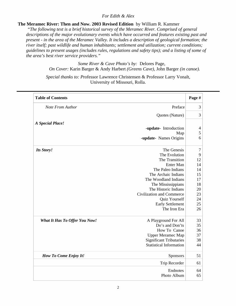
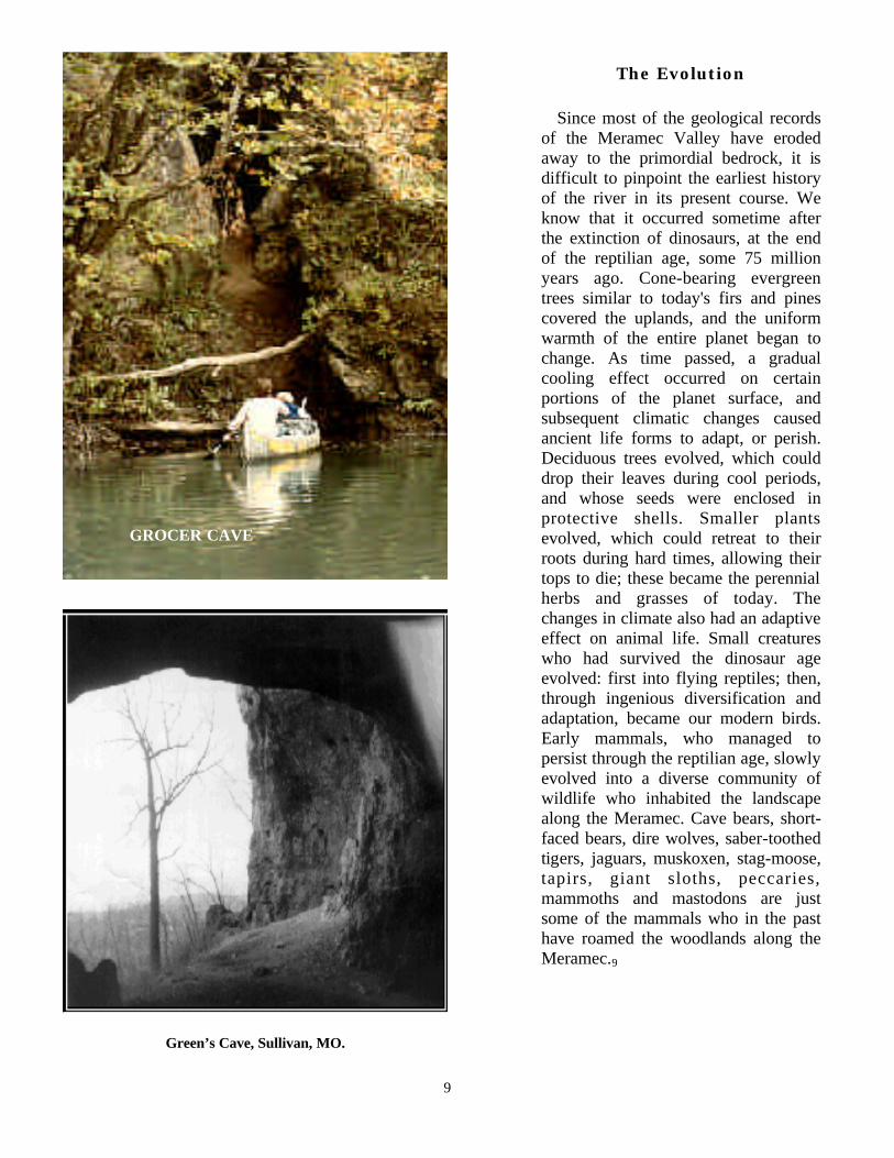
Green’s Cave, Sullivan, MO.
The Evolution Since most of the geological records of the Meramec Valley have eroded away to the primordial bedrock, it is difficult to pinpoint the earliest history of the river in its present course. We know that it occurred sometime after the extinction of dinosaurs, at the end of the reptilian age, some 75 million years ago. Cone-bearing evergreen trees similar to today's firs and pines covered the uplands, and the uniform warmth of the entire planet began to change. As time passed, a gradual cooling effect occurred on certain portions of the planet surface, and subsequent climatic changes caused ancient life forms to adapt, or perish. Deciduous trees evolved, which could drop their leaves during cool periods, and whose seeds were enclosed in protective shells. Smaller plants evolved, which could retreat to their roots during hard times, allowing their tops to die; these became the perennial herbs and grasses of today. The changes in climate also had an adaptive effect on animal life. Small creatures who had survived the dinosaur age evolved: first into flying reptiles; then, through ingenious diversification and adaptation, became our modern birds. Early mammals, who managed to persist through the reptilian age, slowly evolved into a diverse community of wildlife who inhabited the landscape along the Meramec. Cave bears, short-faced bears, dire wolves, saber-toothed tigers, jaguars, muskoxen, stag-moose, tapirs, giant sloths, peccaries, mammoths and mastodons are just some of the mammals who in the past have roamed the woodlands along the Meramec.9
GROCER CAVE

10
The Peccary is a relative of the pig. Two species (the flat-headed peccary and the long-nosed peccary) were present in this area for 33 million years, but became extinct in North America around 10,000 years ago. They both stood about 30 inches tall and weighed about 110 pounds. Peccaries are most easily distinguished from true pigs by their upper canines (tusks), which point downward. A true pigs tusks point upward. Flat-headed peccaries apparently lived in herds and dwelt in caves for shelter. The fossil remains of at least 98 individual peccaries have been found in Bat Cave, Missouri, which probably represents long term usage by herds. On internet at URL: http://www.museum.state.il.us/exhibits/larson/peccary.html
The Short-Faced Bear or “Bulldog Bear” was taller and more slender than the largest brown bears. It had long limbs and was probably capable of great bursts of speed. Stout fangs and vise-like jaws completed its’ predatory equipment. The flattened face and short muzzle of the Bulldog Bear has been described as more like that of a lion than a bear. Heritage Post Interactive - Dec. 1994. On internet at URL: http://trinculo.educ.sfu.ca/jot/bear.html
Sabertooth Tigers were about the size of a modern African lion. Two species existed, one had short legs and 7 in .upper canine teeth, it was most likely an ambush hunter. The second species had longer legs but shorter (4 in.) canines, and probably chased as well as ambushed its prey. These big cats were most likely very effective and aggressive hunters. They walked flat-footed like bears and were not really tigers at all. Their disappearance is linked to the extinction of Mastodons, which were their predominant prey. Microsoft Encarta ‘95 and On internet at URL: http://www.museum.state.il.us.exhibits/larson/
From 10,000 to 40,000 years ago Jaguars roamed this area and the rest of the southern half oF the U.S. They weighed up to 420 lbs. (which is much larger than their modern relatives), and spent some of their time in caves. One of the most interesting jaguar fossil sites in the midwest is in a cave in Perry County, one-hundred miles south of St. Louis, in which numerous ancient jaguar tracks and a jawbone were discovered. On internet at URL: http://www.museum.state.il.us/exhibits/larson/felis_onca.html

11
Ancient Cave Bears were quite a bit larger than their modern descendants, and probably went to caves for occasional shelter. Most of their teeth were pointed, specifically designed for eating meat. Modern bears have developed different types of teeth and will eat a variety of foods. Microsoft “Dangerous Creatures” Microsoft Home Multimedia. 1994
Compared to today’s gray wolf the Dire Wolf had a larger head and teeth, and stouter build (150 - 250lbs), and was probably slower. Exhibiting some hyenalike features, the dire wolf probably relied heavily on scavenging as well as hunting. Steffan O’Sullivan, “The Dire Wolf and Pack Tactics”. Preview of the GURPS Bestiary, on the Internet at URL: http://www.io.com/arcangel/roleplayersWeb-PagesRoleplayer7/BestiaryPreview.html
The Stag-Moose had longer legs and more complex antlers than modern moose, and a face like that of an elk.
Illinois State Museum, “Midwestern U.S. 16,000 Years Ago”. On the internet at URL: http:/www.museum.state.il.us/exhibits/larson/cervalces.html
Two species of Muskoxen roamed this area during the last Ice Age. One is the same species found in the artic today, it roamed the regions south of glaciers. The second species is called the woodland muskox, it became extinct around 10,000 years ago. The woodland muskox roamed the woodlands and plains, and was apparently very common here. Significant muskox fossils have been found in Jefferson and Benton Counties, Missouri. On internet at URL: http://www.museum.state.il.us/exhibits/larson/muskox.html
The Giant Ground Sloth had enormous claws for digging roots, defense, and tearing down trees. llinois State Museum “Mid-western U.S. 16,000 Years Ago”. On internet at URL: http://www.museum.state.il.-us/exhibits/larson/sloth.html

12
The Transition About two million years ago, the Ice Age began. Four times the enormous accumulations of heavy snow in Canada became compacted into great rivers of ice, and inched their way southward to the point where their melting occurred faster then their advance. Of the four, the last advance came closest to the Meramec, leaving granitic rubble a mere 50 miles to the north. It was probably a time of numerous gushing streams and springs, and large scale erosion, but did not destroy the landscape that had already been carved by the river. It did however, force a southward migration of the plant and animal community, which returned centuries later with the retreat of the ice. It is conceivable by some, that the pressure from the immense weight of the ice, through the action of plate tectonics, contributed to the last gradual uplifts of the Ozark Plateau. The Ice Age, and subsequent uplifts, changed the environmental character of the region. At the first assault of the ice, a landscape of soft contours, low hills, and a broad swampy valley existed. Ridge-loving oaks, hickories, and cedars clothed the hills, and sycamores, willows, cottonwoods, and other swamp-loving varieties filled the lowlands. As the region continued to elevate, and drainage increased, the river kept cutting its trough deeper into the bedrock. Eventually, the lowlands became hilltops, and the swampland trees vanished except along the low, wet, river bottoms.10 During the interglacial periods many of the beasts of the era perished, some went into extinction, some still exist, but they all left abundant bone records of their passing in what were once swampy pits and sinkholes, and in the mud of caves. Among them were two elephant-like beasts; the Woolly Mammoth, and the Mastodon. The Mammoth, with its coarse fur, was adapted to cooler, open areas, and probably lived along the glacial frontiers. Its teeth were similar to those of a horse, suggesting that it grazed on low plants, and one tooth could fill a man's hand. The sparse evidence of its existence in the Ozarks is probably an indication that this area was the southernmost edge of its range
North American Mammoth
North American Mastodon
during glacial advances. The Mastodons, however, left abundant remains in the Meramec basin and were surely quite common. Similar in size to Mammoths, but less hairy, their teeth were adapted to grinding coarse materials such as leaf bearing twigs and bushes, and they dwelt in the woodlands. The Ice Age occurred over a period of around two million to twenty thousand years ago, and is considered recent in geological terms. Though it exacted a heavy toll in some of the eras’ animal life, it also created the opportunity for the ever-changing patterns of life to produce new species, as well as a continuing specialized evolution of those that survived. After the Ice Age, and the last elevation of the Ozark Plateau, there occurred an overall enrichment of the diversity of life. Though clearly influenced by the geological changes, topography and climate also contributed strongly to the development of the vast assortment of life that exists there now.11 The hills of the Ozarks were quite steep, and apt to slope off in many differing compass directions, depending on the drainage pattern of

13
each individual locale. But, because the valley runs generally west to east, the sun always shines from the same general southern direction. Therefore, south-facing slopes experience conditions that are much hotter and drier than those facing north. This results in a system of many variations of the two contrasting environments, and the opportunity for a grand variety of life from both environments to exist within proximity of each other. Of equal influence is the position of the Ozarks in the north American continent. Located right in the
climatic transition zone between the drier western prairies, and the dense, humid eastern forest land, the Ozarks have become the home for life forms characteristic of both areas. The diversity of life
includes more than a thousand flowering plants, two hundred varieties of birds, sixty various mammals, fifty different reptiles, and uncountable species of insects. Also, within the Meramec and its tributaries
live a hundred species of fish, forty types of mussels, and thirty kinds of a amphibious life.12
Summer of ‘99 Camping On The Meramec
Waking quietly with the dawn,
mist in the air, and the birds in song. Doe and fawn cross the field,
Geese flying bye, honking say hi! Turkeys dismount from their lofty roosts. Calling their places, forming their groups.
Squirrels bark and chatter at some unwanted guest. Blackbirds argue over last nights scraps.
Robins stalk worms in the fresh cut grass. Peepfrogs are quiet, getting their rest.
Locusts are screeching, they’ve no time to waste. A bullfrog still bellows, come here-make haste.
A woodpecker taps on a thorny locust tree, digging up bugs its collecting for three.
A red-tailed hawk circles the pasture the bunnies are fast but the hawk is still faster.
A flicker sails across the meadow, a falcon dives and the flicker cries.
A buzzard glides way up high. The bluejays holler at a crow too close bye.
A painted turtle sits on a log, and the great blue heron stalks minnow and frog.
A terrapin meanders across the road. As I stoke up the fire I frighten a toad.
A lizard jumps from the stick in my hand, a daddy long legs crawls up my arm, a lightening bug lands on my nose,
but none of us suffer any harm. The coffee smells good and tastes even better
The thick morning mist hugs the ground. Then comes a quick shower,
drops tap on the tent and after it passes the quiet laments
as the drips make their way through the leaves. I tune in on a subtle sensation,
then I feel it and hear it with ease. I pat my dog’s head and close my eyes
and listen to the woods breathe.
by W. R. Kammer, while camping at Ozark Outdoors, Leasburg, Mo. spring & summer 1999

14
Enter Man
One might easily imagine a characterization of the Meramec’s first human inhabitants as people similar to American Indians, galloping through the woodlands on horseback, or navigating the river in dugout canoes and hunting game with the bow and arrow. But, it is much more likely that they traveled on foot, and hunted Mammoth, Mastodon, Giant Bison, Giant Sloth and other Ice Age mammals with spears.13
The Paleo-Indians
The first humans to dwell in the Meramec Valley are called Paleo-Indians, and they arrived around 10,000 to 20,000 years ago. They were Orientals, who probably traveled in small hunting bands. It is believed that they migrated eastward out of Siberia to North America, across the Bering Strait (which was then dry because of the massive impoundment of water in huge northern ice domes), and may have followed the mastodons and woolly mammoths down an unglaciated corridor into the continent. Paleo-Indian tools consist of stone spearheads, knives and scrapers. The Clovis point, which is a large and finely crafted spear head , is the most significant artifact of their existence. Clovis points are extremely sharp, fluted, and designed to allow the spear to be withdrawn from a wound for repeated thrusts into a large formidable prey. Paleo-Indian artifacts have been found at a number of sites in the Meramec Basin, and Clovis points have been found among disarticulated mastodon bones, yielding proof of the association between the oriental hunters and the mastodon. Because of their unencumbered nomadic lifestyle, the Paleo-Indians left scant clues to their culture, and neither did their successors, the Archaic Indians, who were probably descendants.14
Man’s first tools were made using the percussion flaking method of flint knapping (below).
15
The Archaic Indians
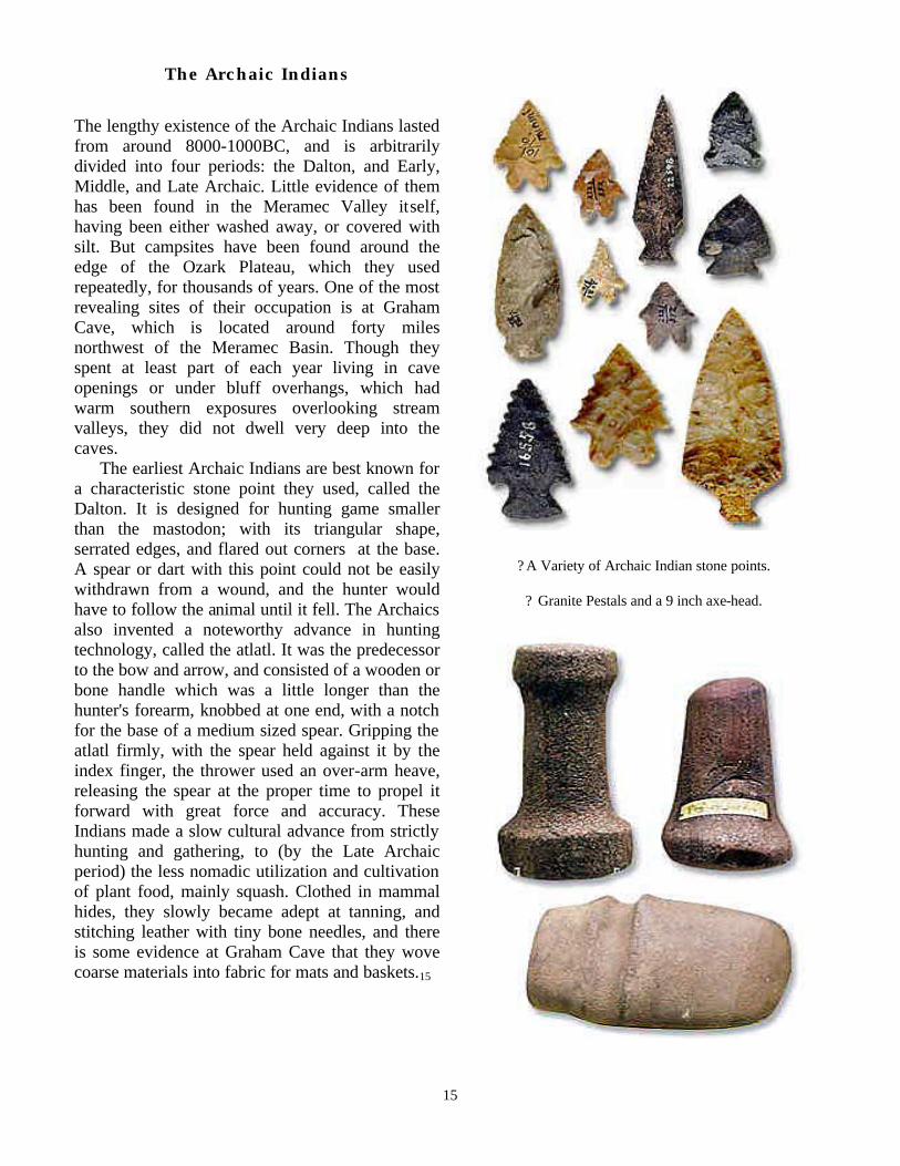
The lengthy existence of the Archaic Indians lasted from around 8000-1000BC, and is arbitrarily divided into four periods: the Dalton, and Early, Middle, and Late Archaic. Little evidence of them has been found in the Meramec Valley itself, having been either washed away, or covered with silt. But campsites have been found around the edge of the Ozark Plateau, which they used repeatedly, for thousands of years. One of the most revealing sites of their occupation is at Graham Cave, which is located around forty miles northwest of the Meramec Basin. Though they spent at least part of each year living in cave openings or under bluff overhangs, which had warm southern exposures overlooking stream valleys, they did not dwell very deep into the caves. The earliest Archaic Indians are best known for a characteristic stone point they used, called the Dalton. It is designed for hunting game smaller than the mastodon; with its triangular shape, serrated edges, and flared out corners at the base. A spear or dart with this point could not be easily withdrawn from a wound, and the hunter would have to follow the animal until it fell. The Archaics also invented a noteworthy advance in hunting technology, called the atlatl. It was the predecessor to the bow and arrow, and consisted of a wooden or bone handle which was a little longer than the hunter's forearm, knobbed at one end, with a notch for the base of a medium sized spear. Gripping the atlatl firmly, with the spear held against it by the index finger, the thrower used an over-arm heave, releasing the spear at the proper time to propel it forward with great force and accuracy. These Indians made a slow cultural advance from strictly hunting and gathering, to (by the Late Archaic period) the less nomadic utilization and cultivation of plant food, mainly squash. Clothed in mammal hides, they slowly became adept at tanning, and stitching leather with tiny bone needles, and there is some evidence at Graham Cave that they wove coarse materials into fabric for mats and baskets.15
? A Variety of Archaic Indian stone points.
? Granite Pestals and a 9 inch axe-head.

16
ATLATL
? Archaic Jewelry: A shoe-sole gorget made from mussel shell.
? An Archaic Nutcracker.
? After discovering the prerssure flaking method of flint knapping (below) man’s stone tool-making skills were
complete.

17
The Woodland Indians The Archaic Indians eventually succumbed to the passing of time and the power of evolution, and a new culture of people emerged, called Woodland Indians. They were most likely Archaic descendants, and made some important advances in the development of native man. Their stone points were much smaller, with corner notches, indicating that they were the first to use the bow and arrow. They also initiated the use of pottery and baskets to store food, and at about the time of Christ, began trading with outside cultures. Chert rock, so useful in making points and tools, and common to the area, was a valuable resource of the time, and the Woodland Indians traded it extensively. They also traded the rich iron ore at Maramec spring and other locations (used to produce crude tools such as mauls and axes), and the red ocher pigment found in the ore, which was highly prized by all cultures of that period. They exchanged these resources for pottery, and pottery making skills, and eventually developed their own unique brand of earthenware. They lived in small villages, on sparsely wooded terraces overlooking the Meramec, and also maintained campsites under the overhangs of bluffs. Their toolmaking skills are clearly evident in the large variety of implements they made from bones and shells. Mussel shells were fashioned into spoons or hide scrapers; antlers provided pressure flaking points for working chert into arrowheads, spearheads, knives, and drills; needles, awls, and pins for making baskets and stitching were made of bone; and clay pipes and beads are also found among their artifacts.16
? Woodland Pottery Shard
? Woodland Pots: left - early period (800-100BC). right - late period (100BC-400AD).
? Woodland Points

18
The Mississippians
The isolated Woodland Indians of the Meramec valley prospered around 400AD, but by 900AD had declined and disappeared without a trace. During their decline, a new advanced culture of people evolved. They are called the Mississippian Indians (or moundbuilders), after the great river valley they inhabited. Skilled at farming, they dwelt in sizable towns, and built large earth mounds which were used for burial and temple sites. Trading over a wide area, they conquered the Mississippi in dugout canoes, and a group of them lived directly across from the Meramec's mouth. Several sites in the lower Meramec valley show signs of their habitation, such as pottery shards at old salt springs and chert deposits not far from Fenton. Also, on many rock outcrops near the Big River in Washington State Park, they left petroglyphs, which are believed to symbolize the initiation from youth to adulthood.17
? Moundbuilder Pottery was high quality and could be quite ornate.
Art of the Moundbuilders: http//:www.cr.nps.gov/aad/feature/artistry/htm
? Mississippian and Late Prehistoric Period, SEAC Prehistory and History :
http//:www.cr.nps.gov/seac/misslate.htm
Carved Ceremonial Effigy Pipes of an Owl, Toad and Raccoon. Animal Effigy Pipes: http//:www.ohiokids.org/ohc/archeol/artifact/tremper.html
? “Ruckers Bottom Mississippian Village,” oil painting by Martin Pate:
http//:www.cr.nps.gov/seac/ruckers.htm

19
The ‘Pirogue’ or ‘Dugout’ Canoe was surely one of the earliest and most enduring of Native American crafts. Making one of these crafts was an arduous task in which fire and crude scraping tools were used to hollow out a large sycamore, cypress, or cottonwood log. This type of craft was used extensively by the Native Americans of the Midwest as well as early immigrants to the area, and varied widely in size and shape. The largest dugouts were up to fifty feet long, five feet in beam, and could hold 30 men and forty or fifty tons of freight. The Birchbark Canoe, also widely used during that time period, was primarily used by northern and eastern tribes.43
Some Types Of Native American Canoes Bark Canoes were narrow, light and shallow-drafted. There have been many styles of Bark Canoes, some of the the most common were: The Two-Man Indian Canoe: 8 to 10 feet in length. The Express or Light Canoe: usually 18 to 21 feet long; used for rapid travel. The North Canoe: A 4- to 8-man canoe which was sometimes used as an Express canoe. The Bastard Canoe: A particular style of 10-man canoe. The Montreal Canoe: A particular style of 8- to 12-man or even 14-man canoe. Wooden Dugout Canoes were most likely the earliest form of water craft in this area, and probably enjoyed the longest use: Pirogues or Dugouts and variants came in numerous sizes with the largest made by splitting a dugout in half longitudinally and then reassembling with planks inserted between the halves. Skin Boats were skin-covered frame canoes which were usually used only as a temporary vessel. Bullboats were a bowl-shaped variation of skin boat that was usually used on streams in crossing from one side to the other.

20
The Historic Indians
The Mississippian culture flourished between 900 and 1300AD, and then, as the Woodland culture before it, mysteriously declined. By the time of Europeans first recorded arrival in the Mississippi valley in 1541, the local population had ebbed for over a century. The first white men to set eyes on the Meramec in the 1670's found the area vacant of prehistoric Indians and, for the most part, historic Indians as well. The Maroa or Tamaroa tribe of Indians (probably Mississippian descendants) lived in Illinois, across from the Meramec’s mouth. They knew the valley well, and acted as guides on many of the first white mining expeditions into the area, directing the French adventurers to age-old crudely worked sites of rich lead and iron deposits, and salt springs. Occasionally, mobile bands of Algonquin Indians passed through the region on hunting or marauding excursions; members of the Sac and Fox tribes came from the north; Osages from the west; and Delaware's and Shawnees from the east. Later, during Spanish control of the Louisiana territory in the late 1700's, Delaware and Shawnee villages were established on the Bourbeuse river and Courtois-Huzzah creeks. It was hoped that they would help control the marauding bands of Osages terrorizing the small mining camps, but this proved to be of no avail, and the last Indians to actually live in the Meramec valley, the Shawnee and Delaware, were eventually driven west into the Indian Territory.18
Cvilization and Commerce
Stone Points from a site near the Bourbeuse R.
Courtesy of Jeff Goodman, 1277 Rock Road Bourbon, MO.
? Indians of the Historic Era (1650-1840’s) liked silver ornaments like these and would trade deer and beaver hides for them.
? European traders could make Iron Points which were stronger and more durable than stone. Indians would trade hides for them.

21
Historic Indian Rock Paintings
Tecumseh (1768?-1813), Shawnee leader, who fought against United States ex-
pansion into the Midwest in the early 19th century. Born in what is now Ohio, he
was the son of a Shawnee chief who was killed fighting white settlers in the Bat-
tle of Point Pleasant (1774). In 1794 Tecumseh took part in the Battle of Fallen
Timbers, in which a coalition of tribes was defeated by the U.S. general Anthony
Wayne. Tecumseh became known for his opposition to any surrender of Native
Horned Black Snake on a rock bluff overhang near the Bourbeuse River. Te-cumseh is said to have gained his power from slaying the horned black snake and carrying its remains in his medicine bag.

22
American land to whites, holding that a cession of land by any one tribe
was illegal without the consent of all the others. He and his brother
Tenskwatawa, a religious visionary known as The Prophet, preached
against Native American adoption of white customs—especially the use
of liquor. In 1808 they were forced out of Ohio and moved to Indiana,
where they tried to form a broad alliance of Native American tribes with
help from the British in Canada. Their plans were thwarted when
Tenskwatawa was defeated by U.S. forces under William Henry Harri-
son at the Battle of Tippecanoe in 1811. Tecumseh fought on the British
side in the War of 1812 and was killed in the Battle of the Thames, near
Thamesville, Ontario, on October 5, 1813.
Native Americans in the north and south were involved in the War of 1812 be-
tween Britain and the United States. In the Old Northwest, Tecumseh, a
Shawnee leader, and his brother Tenskwatawa, known as The Prophet, urged
Native Americans to return to past traditions and to repudiate the white-
imposed concept that individual factions or tribes could sell the land that was a
common heritage of all peoples. William Henry Harrison, governor of the Indi-
ana Territory, who had been warned by Tecumseh in 1810 not to allow white
settlement to proceed further, moved in 1811 to break up the Native American
settlement at Prophetstown, Tecumseh’s headquarters. In the Battle of Tippe-
canoe, Harrison suffered heavy casualties but forced the Native Americans to
abandon the village. This conflict became part of the larger British-American
war, and the Native Americans soon gravitated to the British side. Tecumseh

23
Flatboats were boxlike with flat bottoms, perpendicular sides and usually upturned ends. They were steered by a large oar or sweep at either end and sometimes they were covered for their entire length. This type vessel usually could not return upstream unless pushed by a steamer. Most flatboats were dismanteled at the destination and sold as lumber. Some types of flatboats : Private flatboats were used to transport people, commodities, or produce. Excursion or Pleasure barges were often outfitted with canopies, deck furniture and other features. A Wanigan was a houseboat used as a cook shanty, bunkhouse, or supply boat on log drives etc..
With the arrival of civilization and recorded history, there emerges a better sense of the rugged unyielding nature of the Meramec and its valley. Native Americans had undoubtedly been negotiating the river in pirogues or dugout canoes for a long time before recorded history began, but on a smaller scale, and their stories will never be known. However, the story of civilized mans’ attempts to use the Meramec as a waterway, communication, and commercial trade-route is well known, and reveals the true nature of the river- a nature which has existed since long before the encroachment of man. The rocky terrain of the Meramec valley was covered with dense hardwood forest, and not advantageous to agricultural development, or easy transportation, but still held a bounty of its own-a bounty of ore. Beginning in the early 1700's, mining opened up the area and resulted in many shipments of Lead and Iron down the Meramec to the Mississippi and markets beyond. Fur trappers no doubt made their way up and down the river, harvesting hides for sale or trade. These were the predecessors of the great fur trapping and trading enterprises which opened up the west along the Missouri river and
made St. Louis the fur- trading capital of the world. Those early river men, in their pirogues, flatboats, and keelboats, had to deal with a continuous array of shallow riffles and treacherous snags so characteristic of the Meramec. Often, shippers stockpiled their cargo until the rainy season raised water levels enough to make navigation possible.19 After the development of good wagon roads and then the railroad, cargo shipments on the Meramec rapidly declined, but continued. The development of railroads created a huge demand for crossties. The hardwood forests of the Meramec Valley proved a perfect source for the ties' raw material, and fashioning them provided a subsistence lifestyle for the local settlers. The local men floated the crudely hacked ties down the Meramec to the nearest market to be sold to the railroad.

24
Quiz Yourself
2) Who were the most infamous guys to hang out around the Meramec?
1) What does the name ‘Meramec’ mean?
5) Where on the Meramec is Hinch Rock? 6) How did it get that name? 7) What is another name for that spot?
8) Where on the Meramec is Vilander Bluff (the largest)?
9) How did it get that name?
10) What 10 mile stretch of the river has the coldest water?
11) Who is the new bridge at Leasburg
named after, and why?
3) Where is Scotia?
4) Who was Ralph Brown?
12) What is the safest way to float?
16) What is the slowest way to float?
14) What were hog trough bridges?
15) How did they get that name?
17) What was the first new bridge at Leasburg like and why did it fail?
18) What is the average flow of the Meramec (in gallons) at Sullivan?
13) What is the fastest way to float (non-motorized)?

25
Early Settlement
The quest for precious metals first brought civilized man to the Meramec Valley. In 1541, Hernando de Soto led a Spanish expedition to the area because of rumors of gold and silver. When the expedition ascended the Mississippi River, it sought a place called the ‘land of the Cayas’, the alleged home of gold and silver. From its description, the land of the Cayas must have been the Meramec Valley. DeSoto made it as far as the mouth of the White river in Arkansas before an untimely death took from him the opportunity to become the first Ozark miner.20 The French missionary Father Jacques Marquette and his companion Louis Joliet were probably the first white men to touch the area, while extending their exploration of the Mississippi River from the north in 1673. Other Missionaries also recorded seeing the mouth of the Meramec in the 1670's and 1680's. Upon passing the mouth of the river they noted native accounts of lead in the area. Experience often placed silver and lead together, so the reports increased the likelihood that previous rumors of the presence of silver might be true, prompting further explorations. Miners found little or no silver, but the lead ore proved to be the highest quality in the world, and by 1700, Indians and perhaps some whites mined it. Jesuit Father James Gravier in his "Journal of a Voyage from the County of the Illinois to the mouth of the Mississippi" recorded that "On the 10th day of October 1700, we discovered the river Miaramigoua (Meramec) where the very rich lead mine is situated 12 or 13 leagues from its mouth. The ore from this mine yields 3/4 metal.” At the same time as Father Gravier wrote these words, the Frenchman LeSieur came up the Mississippi as far as the mouth of the Meramec and Pencault, one of his party, officially discovered the first lead in the Mississippi valley along the banks of the Meramec river.21 The French Government had no desire to be directly involved in mining efforts in the area so, in 1717, King Louis XV sold the mining
rights for the Ozark territory to John Law and his "Company of the West.” Law sent the first official mining expedition to the area in 1719, commanded by Phillipe Francis Renault and Ferdinand LaMotte. The party of 400 miners and 500 slaves arrived in the Ozarks in 1720 and to their disappointment found only lead and iron. Renault opened lead mines at Potosi, and La Motte the Mine LaMotte on the St. Francois river. Others of the party came up the Meramec, opening Lead, Copper and Iron mines at the present site of Meramec State Park. A crew of eight men working the 40-45% pure ore of the LaMotte mine could extract, melt, and refine up to 10,000 pounds of lead per month; the ore of the Meramec mines, which was up to 80% pure, could produce proportionally as much as twice that amount. By 1721 producers shipped tons of lead the 55 leagues down the Meramec to the Mississippi in Pirogues carrying 5000 to 6000 pounds each. Then shippers took it 15 leagues upstream to the Illinois, or floated it downstream to New Orleans, and sent it over the Atlantic to France. Except for a brief period of Osage Indian warfare in 1774-1775 these mines produced continuously from Renault's time through Spanish control and the Louisiana Purchase (1803).22 After Moses Austin established the first furnace in Potosi in 1799, and a shot tower on the bluffs at Herculaneum in 1809, the nature of the fledgling mining industry began to change. Local farmers, in the agricultural off-season, worked existing mines or established their own. Using wagons, they took the ore to the nearest furnace for smelting, and the pig lead was taken to the shot towers at Herculaneum or St. Genevieve to be made into cannonballs, rifle-shot, or sheet-lead. By 1819, 38 lead mines and 34 lead furnaces operated in Washington County and many more produced lead in surrounding counties.23 There is a good deal of historical significance attached to the lead mined from the Meramec Valley. The French used it in the Seven Years War; the Americans in the Revolutionary War and the War of 1812; and both sides used it in the Civil War. The Americans used it again in

26
the Spanish-American War and World War I.24 Much of that lead began the journey to distant battlefields in crude, canoe-shaped hollowed-out logs (pirogues -dugouts), or large rectangular shallow wooden boxes (flatboats), floating down the Meramec river. In addition to lead production, there occurred flour, whiskey, lumber, and gunpowder production in the Meramec valley, some of which were shipped via the waterway. In 1819, 16 water-powered Grist Mills were operating on the Meramec and its tributaries. Local farmers would bring the grain to the mills in wagons, to be ground into flour. They sold or traded the surplus flour (if any) down the river. Ten Distilleries were established in the area, along with eight Saw Mills, and a number of Salt Peter caves and a Powder Mill were in operation in present day Meramec State Park near Sullivan.25
The Iron Era
Settlement of the lower Meramec Valley began after the establishment of St. Louis in 1764, but did not reach the headwaters of the river for another fifty years. During that period many Indian rumors of a "great spring" and an "abundance of a material they treasured and also traded" that was "usable in making heavy tools and that provided red ochre"26 circulated throughout the area. The Indians had identified Maramec Spring and the iron ore that existed nearby. In the early 1820's word of an abundance of ore sparked the interest of the adventurous iron-monger Thomas James from Chillicothe, Ohio, prompting him to prospect the area with his most competent associate Sam Massey, in the summer of 1825. They found the place perfect for the production of iron: a large bank of ore, hematite, hardwood timber from which to make charcoal for the furnace, limestone for flux, a large outcrop of sandstone nearby with which to build a furnace, and the large flow of the spring to satisfy power and all other water needs.27 During their exploration of the area Massey and James inspected the Meramec River and believed it to be a suitable shipment route to and
from the Mississippi. Upon their departure for the trip back to Ohio, they had decided to return and establish an ironworks at Maramec Spring. They spent the winter of 1825-26 planning and making arrangements to build an ironworks in the remote Missouri wilderness. They had to transport a small community, with all the equipment and supplies necessary to build the ironworks, some 600 miles from Ohio to Maramec Spring.28 With Massey in charge, the crews set out early in the spring of 1826, some by wagon, some by keelboat down the Ohio River to the Mississippi, then up the Mississippi River to the mouth of the Meramec, and up the Meramec as close as they could get to the Spring. By September of 1826 everyone had arrived and construction of winter quarters had begun. From the very beginning, the Meramec (as a shipping route) proved to be a disappointment to James and Massey. Not even the first keelboat-load of supplies made it upriver the full 172 miles to the Iron Works, nor did many in the years to come. The Upper Meramec, except for seasonal rises, was just too shallow and contained too many snags to permit even light-class keelboat and flatboat passage. Massey would not be discouraged by the hauling problems and continued to transport shipments up the Meramec. He chose the town of Selma, in Jefferson County, fifteen miles below the mouth of the Meramec, as the dropping-off point for the keelboat-loads of large heavy equipment and supplies needed for the Iron Works. At Selma, the closest town on the Mississippi to the Iron Works (65 miles overland, 175 miles by river), the goods were loaded on flatboats and taken up the Meramec as far as conditions would allow, then transported the remainder of the journey in wagons. If the river was too low or frozen, the goods could be transported by wagon the 65 miles to the Iron Works.29 The furnace began production in late 1829, creating the additional problem of transporting the bar and cast-iron products to the markets along the Ohio River, where they were in high demand. The real problem of getting the products out of the Meramec Valley to the

27
Mississippi River prompted Massey to order numerous, often costly, attempts to navigate the Meramec. The difficulty was not getting the shipments down the Mississippi and up the Ohio rivers; that could be accomplished easily and reasonably by steamboat. The Iron Works owned and operated three flatboats which could haul up to 100,000 pounds of blooms each. In May of 1832 a crew of Massey's men successfully cleared the Meramec of logs and snags, and floated some shipments down to the Mississippi. But it soon became evident to Massey that the Meramec would not be the answer to his hauling problems. The River fell rapidly from the Ozark Plateau to the Mississippi, which sometimes caused large and unexpected fluctuations in the water level, making passage difficult or impossible even after improvements. In desperation, Massey even tried hauling the blooms part way to the Mississippi in wagons and floating the rest of the distance, but still experienced many costly failures, and by 1835, he had seen enough, and except for a few
isolated high-water attempts, ceased shipments down the Meramec, and sold the company flatboats.30 Shaken, though undaunted, by their failure to utilize the Meramec, Massey and James turned their attention toward another route: down the Gasconade river to Missouri river to the Mississippi. They began sending wagon loads of blooms the 30 miles to the present day town of Paydown on the Gasconade. Unfortunately, they encountered the same problems as on the Meramec and, despite numerous costly attempts to keep the channel clear, the Gasconade failed to be a reliable route. All Shipments stopped in 1852. Having no other choice, Massey and James turned their attention to the overland routes, which they used extensively until the advent of the railroads. All the while Massey and James tried so hard to find a way to get the blooms to the Mississippi by waterway, a complex system of roads was developed to serve the retail market in the area. Like spokes of a wheel the roads radiated from the Iron Works in every direction,
Keelboats were of plank construction and had interior frames built over a strong, impact absorbing keel. These crafts were usually equipped with masts, sails, rudders, large oars, and were often moved upstream by poling. Ordinary keels were typically 40- to 80-foot length and 7- to10-foot in beam. A Barge was a wider and flatter version which made a good shallow-water vessel.

28
and every sizable town had an outlet store where Iron Works products were sold on a commission basis. The most used road ran from the Iron Works to the Missouri River at Hermann, known as the "Iron Road", and followed the same general course as today's Highway 19. The road to St. Louis, known as the "Wire Road" took the same general route as I-44. The Maramec Iron Works played a significant role in the development of the Meramec Valley. In a unique development, the major industry came first and then settlement occurred around it, rather than the usual pattern of industry following settlement.31 Developers established other Iron Works along the Meramec at Moselle and Huzzah Creek at Scotia in 1849, and Irondale on the Big River in 1857. They also made attempts to ship their products down the river, but experienced the same problems as had Massey and James, and abandoned the practice for the more costly yet reliable method of overland transportation.32
The Tie-Hacker: A Success Story
During the 1850's, the development of the railroads from St. Louis into the Meramec Valley and beyond, started a long and successful era of shipping on the Meramec. An era in which everyone from the poorest backwoods farmer to the rich railroad baron had a role, and the harmony between the river, its valley, and the people who settled there produced a significant contribution toward the taming of the West. The timber of the Meramec Basin, comprised mostly of oak and other hardwood trees, did not contain the large stands of virgin pine that are so easy to harvest and valuable to construction. Subsequently, the lumber barons who cleared the southern Ozark Plateau passed over the area, leaving the hardwood forests to be harvested by the small scale operations of the area's occupants. The construction of rail lines into the general region created a huge demand for hardwood cross-ties. The Pacific Railroad (which later became the Missouri Pacific) came first and ran westward along the Missouri River to Jefferson City; the second, the Iron Mountain Railroad, followed the eastern edge of the Meramec Valley to Ironton; and the third, the Southwest branch of the Pacific Railroad (which later became the Frisco) followed the general route of I-44 to Rolla.33 It takes three thousand cross-ties to lay a mile of track. A significant number of the ties laid down across Missouri and the Great Plains came from the Meramec Valley. Many frontier farmers made much needed cash by hand-hacking cross-ties in the agricultural off-season. Working alone or with a small group of others, they would fell medium sized trees, cut them to length (eight feet), and using a broadax, hack them to the correct dimensions of six by eight inches. After scoring them for identification, they hauled the ties in wagons to the Meramec or nearest floatable tributary, stacked them above flash-flood range, and when the water level reached the proper height, floated them down the river to the nearest rail crossing or market. They floated the ties either singly or in rafts, depending on the size of the channel. A tie usually brought the hacker less than fifty cents for all his arduous labor. Despite the low wages, tie-hacking provided a means of subsistence, and for some, became more than a seasonal occupation. In the years after the Civil War, many of the tie-hackers who had exhausted their own supply of timber reverted to living by the old outdated code of early settlement times in which wild lands were open to free pursuits. They trespassed indiscriminately, and when asked where they got the trees, would answer "On Grandma's land", as an indication that they had stolen them. From these practices grew the cult of the tie-hacker and his depiction as a shiftless, untrustworthy character. In spite of the increased settlement and private ownership of the lands, the Ozark Tie-Hacker persisted in his trade until he no longer needed to float "Grandma's trees" down the Meramec. He could haul them to market with a secondhand old truck.34
29
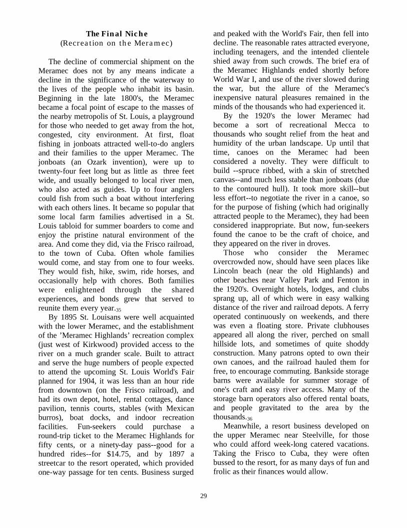
The Final Niche (Recreation on the Meramec)
The decline of commercial shipment on the Meramec does not by any means indicate a decline in the significance of the waterway to the lives of the people who inhabit its basin. Beginning in the late 1800's, the Meramec became a focal point of escape to the masses of the nearby metropolis of St. Louis, a playground for those who needed to get away from the hot, congested, city environment. At first, float fishing in jonboats attracted well-to-do anglers and their families to the upper Meramec. The jonboats (an Ozark invention), were up to twenty-four feet long but as little as three feet wide, and usually belonged to local river men, who also acted as guides. Up to four anglers could fish from such a boat without interfering with each others lines. It became so popular that some local farm families advertised in a St. Louis tabloid for summer boarders to come and enjoy the pristine natural environment of the area. And come they did, via the Frisco railroad, to the town of Cuba. Often whole families would come, and stay from one to four weeks. They would fish, hike, swim, ride horses, and occasionally help with chores. Both families were enlightened through the shared experiences, and bonds grew that served to reunite them every year.35 By 1895 St. Louisans were well acquainted with the lower Meramec, and the establishment of the ’Meramec Highlands’ recreation complex (just west of Kirkwood) provided access to the river on a much grander scale. Built to attract and serve the huge numbers of people expected to attend the upcoming St. Louis World's Fair planned for 1904, it was less than an hour ride from downtown (on the Frisco railroad), and had its own depot, hotel, rental cottages, dance pavilion, tennis courts, stables (with Mexican burros), boat docks, and indoor recreation facilities. Fun-seekers could purchase a round-trip ticket to the Meramec Highlands for fifty cents, or a ninety-day pass--good for a hundred rides--for $14.75, and by 1897 a streetcar to the resort operated, which provided one-way passage for ten cents. Business surged
and peaked with the World's Fair, then fell into decline. The reasonable rates attracted everyone, including teenagers, and the intended clientele shied away from such crowds. The brief era of the Meramec Highlands ended shortly before World War I, and use of the river slowed during the war, but the allure of the Meramec's inexpensive natural pleasures remained in the minds of the thousands who had experienced it. By the 1920's the lower Meramec had become a sort of recreational Mecca to thousands who sought relief from the heat and humidity of the urban landscape. Up until that time, canoes on the Meramec had been considered a novelty. They were difficult to build --spruce ribbed, with a skin of stretched canvas--and much less stable than jonboats (due to the contoured hull). It took more skill--but less effort--to negotiate the river in a canoe, so for the purpose of fishing (which had originally attracted people to the Meramec), they had been considered inappropriate. But now, fun-seekers found the canoe to be the craft of choice, and they appeared on the river in droves. Those who consider the Meramec overcrowded now, should have seen places like Lincoln beach (near the old Highlands) and other beaches near Valley Park and Fenton in the 1920's. Overnight hotels, lodges, and clubs sprang up, all of which were in easy walking distance of the river and railroad depots. A ferry operated continuously on weekends, and there was even a floating store. Private clubhouses appeared all along the river, perched on small hillside lots, and sometimes of quite shoddy construction. Many patrons opted to own their own canoes, and the railroad hauled them for free, to encourage commuting. Bankside storage barns were available for summer storage of one's craft and easy river access. Many of the storage barn operators also offered rental boats, and people gravitated to the area by the thousands.36 Meanwhile, a resort business developed on the upper Meramec near Steelville, for those who could afford week-long catered vacations. Taking the Frisco to Cuba, they were often bussed to the resort, for as many days of fun and frolic as their finances would allow.

30
Due to the large numbers of people frequenting the river (many of which could not swim), there were inevitable drownings, and the bad publicity prompted many to view the Meramec as extremely dangerous. As a result, a group of experienced, trained men organized the Meramec River Patrol in 1928. Usually in canoes, volunteers patrolled assigned segments of the river from the first of May to the last of September. They rescued ten people during their first year of vigilance, but improved their organization, and in 1929 boasted of having a role in more than eighty rescues. The Meramec River Patrol were committed men, who voluntarily performed at least twelve hours of duty per month, until the demand for men during World War II decimated their numbers. But by then, they were no longer needed.37 During the Great Depression, which preceded WWII, the recreational potential of the Meramec became
neglected. The abandoned beaches were overgrown with willows, the lodges empty, and the clubhouses fell into disrepair. After World War II, an era of prosperity occurred which featured the mobility of mass numbers of automobiles, and the people were lured elsewhere. Sites like Yellowstone Park, the Grand Canyon, and the large man made impoundment's of dammed rivers in southern Missouri became the vacationer’s choice.
Department of the Interior, Bureau of Outdoor Recreation, National Park Service,Meramec River Basin October 1969. 29, 30.

31
In the 1950's the river was still being enjoyed by local inhabitants, and a few habitual float fishermen and die-hard canoeists who frequented the upper portions. These few outsiders, however, were seen as a problem to the local farmers whose lands bordered the Meramec. Many of them had strung wire fences across the river to more easily contain their pasturing livestock, and passing floaters were either turned back (sometimes at gunpoint), or paid a passage fee. In 1954 a test case concerning passage on the upper Meramec came to the courts. It was near the community of Cook Station that a gentleman named Elder and his wife launched their craft at a legal access. They floated and fished harmlessly along, and upon encountering a fence, maneuvered across it, at which time the fence & landowner named Delcour informed them that they could not trespass through his land (which was clearly posted). Disregarding Delcour (they really had no choice), the Elders proceeded, and Delcour filed trespassing charges with the Dent County Court, but the court ruled against him. He then took the case to a state appeals court, which ruled in his favor, upholding the trespass claim. Eventually, the decision landed in the hands of the Missouri Supreme Court, whose ruling is still applicable to all comparable cases concerning Missouri streams. The ruling was made in favor of the Elders, because even though the stretch of the river in question was not navigable in the traditional commercial sense, it had been widely used years before to float crossties to market, and was easily negotiable for floating and fishing. The river therefore, had to be construed as a public resource, and the Elders, who had stayed within high- water banks, could not be considered trespassers.38 Since the 1950's, the lower Meramec has fallen prey to the self-serving development of man, through stripping the land for farming, mining enterprises, and gravel dredging. A notable example of the adverse side-effects of unregulated commercial greed on the environment occurred on the largest tributary of the Meramec, the Big River, in 1977. A huge dike (almost a mile square) filled with sterile
barite ore tailings burst due to heavy spring rains. Thousands of cubic yards of clay and barite waste poured into the river through a sixty feet deep breach in the dike wall, affecting the river for thirty miles downstream. Though the lower Meramec has become subjected to man's thoughtless tendency to choose quick profits and immediate gratification over long term protection of his environment, the upper Meramec is still in a relatively pristine state.39 Attempts have been made to dam the Meramec, by the Corps of Engineers, and at one point, near Sullivan, millions of dollars were spent forcing people off their land and building the beginnings of the dam. But, the will of the people prevailed, and on August 8, 1978, a public vote killed the project. The Corps of Engineers seemed, at that time, to consider dam building as the answer-all to the problem of failing rivers. But out of the melee, came some redemption for the Meramec. Of the land purchased by the Corps of Engineers, the 20% deemed to have the most intrinsic natural value to the preservation of the Meramec remained in public ownership. Laws were enacted to protect the river’s environment, and an easement allowed, along both banks, to act as a “recreational corridor for canoeists.”40 In an apparent effort to recoup its losses, the Corps offered to the people who were forced off their land because of the Meramec Dam project, the opportunity to buy it back over a decade later, before putting it up for sale to the general public. Though the buildings were destroyed, fences collapsed, and fields overgrown, the original owners were often forced to pay much more than the amount they were given when they were pushed out. Some families could not afford the exorbitant prices, and lost forever the land that had been in their families for generations, all for a dam that wasn't wanted, and never happened, and some bitterness still lingers in the affected area.

32
Department of the Interior, Bureau of Outdoor Recreation, National Park Service,Meramec River Basin October 1969. 29, 30.
? Blow-up of above photo.

33
A Playground For All! Presently, the upper Meramec remains a playground for St. Louis, its natural state protected for future generations, and enjoyed by untold thousands of people annually. The industry that has developed around its recreational use pours much needed revenue into a rural economy which often lacks ample opportunities for employment or profitable business ventures. Local float liveries offer a variety of options to floaters; inner tubes, kayaks, canoes, jonboats, and river rafts, are instantly available to satisfy the needs of even the most discriminating floaters. Riverfront campgrounds and lodges offer everything from primitive camping, to horseback trail rides, to catered luxury cabins. Nearby, there is ample state forest and numerous wildlife and conservation areas set aside for hiking, hunting, and exploring nature. Meramec State Park in Sullivan offers a wide variety of services and activities (including a tour of Fisher Cave), and the natural wonders of Onondaga Cave and Meramec Caverns complete the setting. During summer months, hordes of relief seeking city dwellers, and others, come to enjoy the simple yet satisfying outdoor pleasures of the river. Leaving the noisy hustle bustle of modern life behind, they lose the stress, and relax for a time, while gliding over cool clear water, past scenic bluffs and forests. People of all walks of life and socio-economic levels come and enjoy the natural environment and, in the water or on the beaches, many of the social trappings and divisions which normally separate them disappear. After all, as the river rises from many connected sources to become one, we are all part of a river of humanity, equally connected to our genetic ancestral sources. What better way can there be to renew the connection with our primordial past, and revive the pleasure of our natural heritage, than being in, on, or around, the Meramec River.41
What It Has To Offer You Now!

34
? At Beach Near Birdsnest
Riverman Charlie Barger Gone But Not Forgotten
? At Fishing Spring Cave

35
River Do’s & Don’ts (Put Safety First)!
The precepts listed below will help insure that you and those around you have a safe enjoyable experience of the Meramec. Most of them are just plain common sense guidelines, but I am listing them anyway because sometimes (especially during the excitement of having fun or while under the influence of alcohol etc.), a person’s common sense may leave him/her. Please, when in - on - or around the river, keep the following points in mind: ? Life-jackets and other floatation devices are for your protection, by state law there must be a floatation
device for each person in your craft, and children seven years old and under must wear a floatation jacket or vest at all times. From my experiences of putting thousands of people on floats I suggest that anyone who is not a strong swimmer, feels apprehension on the water, is overly intoxicated, and all children should wear a jacket or vest.
? Never dive into water that you haven’t checked for proper depth and underwater obstructions. ? Avoid swimming in fast water, use the slow spots and backwaters for play. ? Never sit or lay in your craft with your arms or legs under the seats, thwarts, or other fixtures (especially
children). Be easily able to swim free of your craft should a spill occur. ? If a spill does occur, don’t try to swim against the current, swim and float with the current to the nearest
bank (avoid snags and log-jams). ? Steer your craft well clear of other crafts and obstructions in the water, if a collision is going to occur grasp
the sides of your craft and use your weight and balance to attempt to keep the craft upright. ? Keep your gear in water-tight containers that are firmly attached to your craft. ? Get off of the water during severe electrical (lightning) storms. Don’t take a float that is too long for the amount of time you want to spend, most people enjoy a leisurely trip more than a hurried one. Floating times vary according to the type of craft, river conditions, and how hard you paddle: 5 miles nonstop in a canoe = 2 - 3 hrs.avg. (light paddling). 5 miles nonstop in a raft = 4 - 5 hrs.avg. (light paddling).
Don’t TIE Multiple Boats Together!
This practice may at first seem harmless, and it can be fun for groups to connect their boats and float as a single craft (I have done it myself), but there are safety and courtesy concerns which arise from this practice that all floaters and river utilizers should be aware of: Steering groups of boats tied together becomes very difficult, they go wherever the current takes them. For that reason floaters who engage in that style of floating often just assume that everyone else in or on the river is just going to get out of their way. This is rude, inconsiderate, illegal and can be dangerous! The same principles of common courtesy which exist on our streets, sidewalks etc. apply to travelers on the river. If you must connect your boats, do so in a way that they can be quickly and easily released, and when around others in or on the water, float separately. An example of the danger involved in tieing boats together happened to my four year old son in July of 1998. It could very easily have resulted in his drowning. My family and I were camping on the riverbank near Leasburg and a large group of college students in three ten-man rafts tied together came down the river. The students had just put-in a short distance upstream and were not intoxicated, but were partying and not really paying any attention to where they were going or what was in their path. The passengers in the front of the rafts were facing the rear and no-one was paddling or even had a paddle in his/her hand. Everyone out in the water had to scramble to get out of their way as they came down the river, and as they neared the point where my family and I were swimming the current swept them over right at us. My son Alex was sitting in twelve-inch deep water about three-feet from the bank and the closest raft ran right over him. At the last instant he saw the raft and backed up so it only went over his legs and waist, but he very easily could have had his back to them and been pinned under the raft and possibly drowned (the raft with passengers probably weighed 2000lbs). I was only a few feet away and with much haste and effort grabbed a D-ring on one of the rafts and pulled them away from the bank. I was quite angry and yelled at them to watch where they were going. They all just smiled and went on down the river, oblivious to the dangerous situation they had just caused.

36
HOW TO CANOE* Keeping your canoe moving downstream is easy on the streams of the upper Meramec region. You just have to keep the boat pointed in the way you want to go, and let the river do the work. Yet, experience has shown this is not as simple as it appears.
The trick is to get a good start: make sure that the person sitting in the front has enough leg room. (Last summer a friend of ours spent her first float paddling the bow position in a reversed canoe. She had 4 inches of leg room for the trip, and not a very good time.) Generally the person in the front paddles straight forward and the one in the stern also provides forward umph, but is responsible for steering and not tipping. We might as well face one big issue right off - keeping the canoe steered property can be a source of friction in relationships, platonic or otherwise. Floating can be as challenging as hanging wallpaper. While each couple will have to figure their own way of getting downstream, we suggest that the person in the back worry about the steering and the bow paddler try to provide gentle reminders that a rock or whatever is dead ahead. The bow person makes the best lookout.
The forward stroke is the same for both bow and stern paddlers. Of course there's all kinds of fancy techniques you can learn, but you should know that the upper hand on the paddle grips the handle on top, and does not hold the thing like it was a golf club. The lower arm, holding the paddle's throat - does most of the work, so you might switch paddling sides once in a while to keep both arms evenly exercised. To turn the canoe, the stern paddler can do one of two things. He or she can do a forward sweep stroke which will turn the canoe toward the side opposite you're paddling on. To do this stroke, you reach the paddle out in front, but instead of pulling it down alongside the canoe, you reach out the blade in the water, making a 'C' shape as if stirring a huge kettle of apple butter. Pull the paddle in as far behind you as you stuck it out in front, then lift it out and do another if necessary. A quicker way of turning is the reverse sweep. It is based on that same ‘C’ shape in the water, but do it backwards, so the paddle is moved toward the bow. The stroke, if done with a fair amount of force, is usually so powerful that it's
* An excert from: Enjoying the Upper Meramec: a guide for floaters with basic canoe techniques described. Editorial committee: Jim Jackson, Sandy Primm, Carol Springer. 1980 The Kansas City Star Co. (Reprinted by permission of Carol Springer).
necessary to do only halfway. Just take the paddle out of the water when your arm holding the throat of the paddle is fully extended in the middle of the stroke. It's best to use these reverse sweeps when a quick turn is necessary.
Even on straight stretches of river, keeping the canoe going straight isn't a simple matter. The easiest way to go straight is for the two floaters to have their paddles on opposite sides of the canoe and both paddle straight ahead. If you just paddle like that, the canoe ends up going off to one side, right? Okay, to prevent this, the stern person should do the 'J' stroke every second or third stroke. This is probably the trickiest stroke to pick up: you do about three-quarters of a normal stroke, then instead of bringing the paddle straight back, you give the blade a one-quarter turn outward to put a tiny reverse sweep on the end of the stroke. That makes the hook of the 'J'. It'll take a bit of practice to get this one. If you are too frustrated and can't seem to see how the 'J' stroke works, you can always both switch paddling sides every five or six strokes. But that's a hassle.
The only other stroke the sternperson must know is the backwater. It's simply paddling backwards. It will stop you, but not on a dime. So if you do have to stop, it may be best to hop out - making sure the water's not too deep - and hold onto the pointer (the line tied to the stern or bow) so the canoe doesn't go off without you.
The one special stroke the bow person should know is the 'draw stroke' or 'pull-to'. Both names describe it well: you stick the paddle deep in the water as for out directly opposite from you as you can. Then pull it in, mainly with the lower arm, to you. The draw stroke takes you towards the side you do it on. You'll need to do left or right draws when rocks or riffles or trees come up. The stroke moves the bow over quickly but does not turn the stern as well, so the person in back had best be ready to also do a draw stroke, or a sweep, when the person in the bow finds it necessary to do this maneuvering.
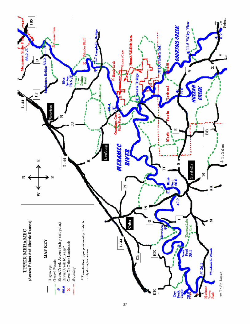
37

38
SIGNIFICANT TRIBUTARIES OF THE MERAMEC Usage and recreational potential of these streams is easily understated and/or overlooked.
Mississippi R.
Missouri R.
St. Louis
Meramec R.
Big R.
Bourbeuse R.
Courtois-Huzzah Creeks
Meramec R. Dry Fork
Maramec Spring
Maramec Spring 37
Courtois-Huzzah Creeks 38
Bourbeuse River 39
Big River 40
A Word About The Lower Meramec 41
Tributary page

39
MARAMEC SPRING PARK Privately owned and managed by the James Foundation (but open to the public), and located near highway 8 and the Meramec (a few miles south of St. James Missouri), the site of the aforementioned ironworks has been naturalized and transformed into an enlivened symbiotic blend of nature, trout fishing, and history. As a symbol of - and in honor of - the past, some of the original ironworks is still intact for visitors to observe, plus the Maramec Museum of the Ironworks history. There is also a Nature Center which details plants and animals of Maramec Spring and its surrounding area. A trout rearing facility has been established near the mouth of the Spring, and the lower three-quarters of the Spring’s journey to meet the Meramec has been beautifully embellished, developed, and reborn into a lovely trout fishing area (stocked daily). The park is rich in living examples of local wildlife, many of which have grown accustomed to human presence and are easily observed and admired. To me, this park is a very special place, which I recommend highly to area visitors, but to avoid crowds I usually go on weekdays. I have personally brought home numerous full limit stringers of tasty and feisty fighting 12 -18 inch rainbow trout (and an occasional brown trout) from this park, and have witnessed the taking of some much larger fish. The ten mile stretch of the Meramec below its confluence with the spring also produces large numbers of good sized trout, and has been deemed a ‘trophy trout area’ by the Missouri Department of Conservation. A daily trout tag is required to fish in the park, and a MDC trout fishing permit to fish the trophy trout area, with specialized and individualized rules and regulations applicable to each area. Even though the rainbow and brown trout (and some hybrid species) introduced and maintained in these areas did not occur naturally, they thrive there, and have become a source of great angling fun and palate pleasure to many of the large numbers of visitors to frequent the area.

40
RECREATION ON THE CREEKS. The cold, chrystal clear waters of the Courtois - Huzzah creeks also offer some of the finest floating-fishing-swimming and natural environments I have had the pleasure to experience. The creek channels are significantly smaller and shallower than the Meramec, and as water levels recede in mid to late summer even canoes may occasionally drag bottom. But, there is still safe navigable passage, the water quality is unsurpassed, and during times of excessive rains and high water the creeks recede to safe floating levels much faster than the Meramec and can provide an enjoyable, comparable option at times that the Meramec is unfloatable. For those who prefer a challenging, more exciting float, the creeks during slightly or moderately high water can most surely provide them with their needed adrenaline fix. As tributaries of the Meramec, the history of the creeks parallel that of the Meramec in many respects, and they may all be considered as part of the same overall water course. An Iron works operated on the Huzzah near Scotia around the mid-1800’s, grist mills operated at various locations, and railroad ties were hacked from the surrounding wilderness and (during high water) floated down to the Meramec and the nearest railroad connection. For those who would like to witness a bit of Huzzah antiquity first-hand, there is The Dillard Mill State Historic Site (near Davisville). The gristmill has been restored to operational order, and guided tours are available free of charge -call 573-244-3120 for more information. The headwaters of the Huzzah Creek are the East Fork and West Fork Creeks of Dent county, and the Crooked Creek of Iron county. The East and West Forks converge Near the Dent-Crawford county line, about another mile into Crawford County the Crooked Creek joins the flow, and the Huzzah is born. Through twists and turns the Huzzah takes a generally northern (approx.40 mile) course to its confluence with the Meramec (note: some maps include the East Fork Creek as part of the Huzzah which may add approx. 10 miles to the
previously mentioned length). About 1/4 mile before the low water bridge at Scotia, the Huzzah accepts the cold crystal clear waters of the Courtois Creek (on the right). The Courtois Creek begins in Iron county (to the east) and runs a generally parallel (approx. 30 mile) course to its confluence with the Huzzah. After the merge, their combined flow takes a northwestern course for 11/2 miles before emptying into the Meramec. The short run of the course of both of these Creeks may at first imply an unlikelihood of high-order recreation potential, but in reality these streams offer some of the finest fishing, floating, and swimming fun that exists anywhere, and they should not be overlooked.

41
The Bourbeuse River The Bourbeuse River skirts the northern edge of the Meramec Basin, and is somewhat sluggish and more mean-dering than the Meramec’s other tributaries. The softer rock (predominantly sandstone) which underlies much of the river’s channel accounts for the high proportion of silt it carries and some of its murkiness. Due to its sluggish, murky nature the Bourbeuse is not visited by the large numbers of floaters that frequent the Upper Meramec and its Courtois-Huzzah Tributaries, but it does provide high utility as a public fishery. Populations of Black Bass, Catfish, Panfish and Suckers have traditionally been high within the Bourbeuse, and even though populations in some areas have decreased, the likelihood of finding some great angling or of filling your stringer is still quite good. The Bourbeuse River runs an approx. 130 mile northeastern course from its sources (near Little Prairie Lake) to its confluence with the Meramec near Union, and has some noteworthy tributaries (for fishing) such as Brush Creek and Little Bourbeuse Creek.
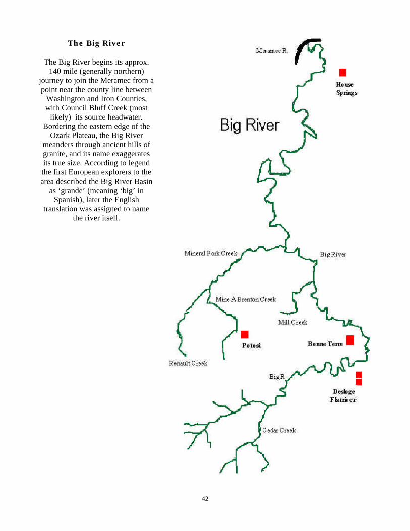
42
The Big River
The Big River begins its approx.
140 mile (generally northern) journey to join the Meramec from a point near the county line between
Washington and Iron Counties, with Council Bluff Creek (most
likely) its source headwater. Bordering the eastern edge of the
Ozark Plateau, the Big River meanders through ancient hills of granite, and its name exaggerates its true size. According to legend the first European explorers to the area described the Big River Basin
as ‘grande’ (meaning ‘big’ in Spanish), later the English
translation was assigned to name the river itself.

43
A Word About The Lower Meramec The natural setting of the upper Meramec area and pristine condition of the river there, draws large numbers or recreation-seekers to the region annually. Therefore most of the recreational oriented information provided in this text deals specifically with the upper Meramec area. Water clarity drops and temperature rises significantly as the river approaches its confluence with the Mississippi, and the natural setting along the river’s banks suffers due to development, but swimming, fishing and especially boating opportunities still abound. Areas like George Winter Park attest to this. The park is located at the site of an old gravel dredging operation which lasted many years and left a large area of open water adjacent to the river’s channel. It is a boaters paradise and the site of an annual national speedboat race. As a youth my first contacts with the river occurred on the lower stretch of the river near Times Beach, and I have many fond memories of times spent there. The recreational potential and opportunities present in that stretch of the river may be right for you and should (if your interested) be explored.

44
STATISTICAL INFORMATION
The following facts and figures concerning the Meramec Basin, River and its Tributaries are taken from: THE MISSOURI WATER QUALITY BASIN PLANS
(1981, Vol. 5) Note:
The Stream Flow Tables in the following section list available data for maximum high-water, minimum low-water, average, and 7-day Q2 water flow, recorded over a specific period of time at specific locations along the river’s course. The diverse highly-fluctuating nature of the Meramec’s water levels is apparent in the extreme variation of the flow figures.
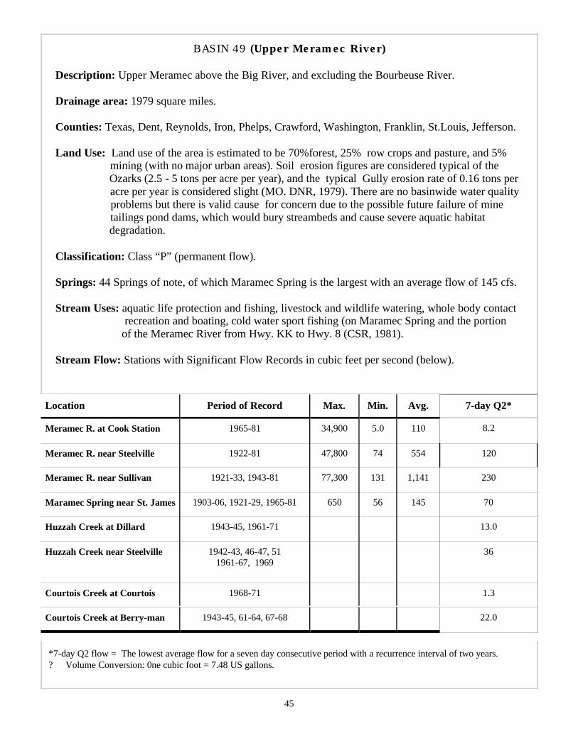
45
BASIN 49 (Upper Meramec River) Description: Upper Meramec above the Big River, and excluding the Bourbeuse River.
Drainage area: 1979 square miles. Counties: Texas, Dent, Reynolds, Iron, Phelps, Crawford, Washington, Franklin, St.Louis, Jefferson. Land Use: Land use of the area is estimated to be 70%forest, 25% row crops and pasture, and 5% mining (with no major urban areas). Soil erosion figures are considered typical of the Ozarks (2.5 - 5 tons per acre per year), and the typical Gully erosion rate of 0.16 tons per acre per year is considered slight (MO. DNR, 1979). There are no basinwide water quality problems but there is valid cause for concern due to the possible future failure of mine tailings pond dams, which would bury streambeds and cause severe aquatic habitat degradation. Classification: Class “P” (permanent flow). Springs: 44 Springs of note, of which Maramec Spring is the largest with an average flow of 145 cfs. Stream Uses: aquatic life protection and fishing, livestock and wildlife watering, whole body contact recreation and boating, cold water sport fishing (on Maramec Spring and the portion of the Meramec River from Hwy. KK to Hwy. 8 (CSR, 1981). Stream Flow: Stations with Significant Flow Records in cubic feet per second (below).
Location Period of Record Max. Min. Avg. 7-day Q2*
Meramec R. at Cook Station 1965-81 34,900 5.0 110 8.2
Meramec R. near Steelville 1922-81 47,800 74 554 120
Meramec R. near Sullivan 1921-33, 1943-81 77,300 131 1,141 230
Maramec Spring near St. James 1903-06, 1921-29, 1965-81 650 56 145 70
Huzzah Creek at Dillard 1943-45, 1961-71 13.0
Huzzah Creek near Steelville 1942-43, 46-47, 51 1961-67, 1969
36
Courtois Creek at Courtois 1968-71 1.3
Courtois Creek at Berry-man 1943-45, 61-64, 67-68 22.0
*7-day Q2 flow = The lowest average flow for a seven day consecutive period with a recurrence interval of two years. ? Volume Conversion: 0ne cubic foot = 7.48 US gallons.
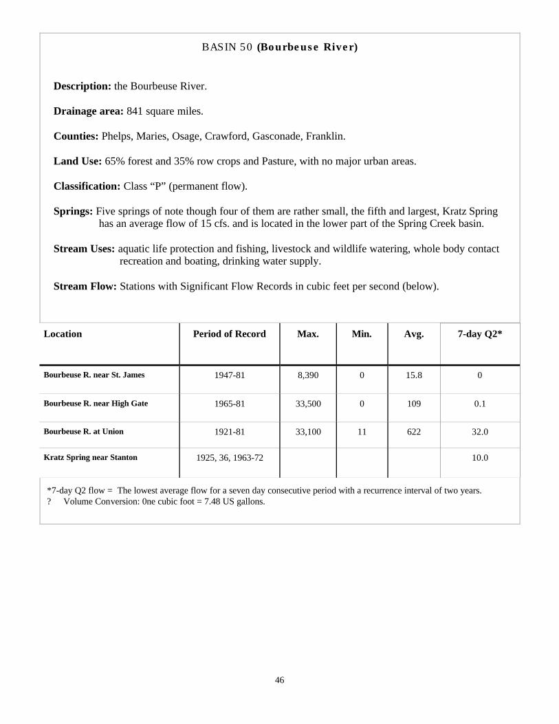
46
BASIN 50 (Bourbeuse River) Description: the Bourbeuse River. Drainage area: 841 square miles. Counties: Phelps, Maries, Osage, Crawford, Gasconade, Franklin. Land Use: 65% forest and 35% row crops and Pasture, with no major urban areas. Classification: Class “P” (permanent flow). Springs: Five springs of note though four of them are rather small, the fifth and largest, Kratz Spring has an average flow of 15 cfs. and is located in the lower part of the Spring Creek basin. Stream Uses: aquatic life protection and fishing, livestock and wildlife watering, whole body contact recreation and boating, drinking water supply. Stream Flow: Stations with Significant Flow Records in cubic feet per second (below).
Location Period of Record Max. Min. Avg. 7-day Q2*
Bourbeuse R. near St. James 1947-81 8,390 0 15.8 0
Bourbeuse R. near High Gate 1965-81 33,500 0 109 0.1
Bourbeuse R. at Union 1921-81 33,100 11 622 32.0
Kratz Spring near Stanton 1925, 36, 1963-72 10.0
*7-day Q2 flow = The lowest average flow for a seven day consecutive period with a recurrence interval of two years. ? Volume Conversion: 0ne cubic foot = 7.48 US gallons.

47
BASIN 51 (Big River) Description: the Big River. Drainage area: 964 square miles. Counties: Iron, St. Francois, Ste. Genevieve, Washington, Franklin, Jefferson. Land Use: 60% forest and 30% row crops and Pasture,and 10% mining, with no major urban areas. Classification: Class “P” (permanent flow). Springs: There are only six springs of note in the Big River Basin (surprisingly), with a combined average flow of less than 5 cfs. Stream Uses: aquatic life protection and fishing, livestock and wildlife watering, whole body contact recreation and boating, industrial, irrigation.. Stream Flow: Stations with Significant Flow Records in cubic feet per second (below).
Location Period of Record
Max. Min. Avg. 7-day Q2*
Big River at Irondale 1965-81 43,200 2.2 164
Big River near De Soto 1948-81 55.800 20 638 88.0
Big River at Byrnesville 1921-81 42,100 25 821 96.0
*7-day Q2 flow = The lowest average flow for a seven day consecutive period with a recurrence interval of two years. ? Volume Conversion: 0ne cubic foot = 7.48 US gallons.

48
Meramec River Fishing The following section is designed to provide those who desire to wet a line in the Meramec with the pertinent information concerning rules, regulations, species, sizes, limits, and records. Due to the almost limitless opinions on the best ways and means to catch fish I am not going to attempt to convey particular instructions on HOW to fish, or WHAT species to fish for , that is up to a particular anglers taste and personal preferences. It is however very important that ALL anglers be aware of the rules and regulations and principles of conservation and resource management which govern the body of water in which they are fishing. Awareness of and respect for the rules and principles involved will not only prevent a costly fine and ruined trip if you are discovered violating the rules, but also will help to insure the preservation and existence of angling pleasure for your own future enjoyment, as well as that of future generations.
“Many times over the years I have seen floaters come in off of the river tired, or intoxicated, or both, with undersized fish or small stringers of fish, only to throw them away for lack of desire or energy to clean and store them. Please remember, size limits exist to protect the resource and promote the likelihood of your own as well as others angling pleasure, and when you do put a fish on your stringer you make a moral commitment to consume the resource”. -BK-
MDC Guidelines for Catch-and-Release.
? If possible, do not take the fish out of the water.
? Filing down the barbs on your hooks makes removal much easier.
? Never pull the hook from the fish’s mouth or stomach (most hooks will rust away).
? Avoid excessive handling of the fish. ? When handling the fish don’t squeeze or
drop it. ? Don’t put your fingers in the gills or eye
sockets. Protect our fishing future—”catch on” to Catch-and-Release.
The information herein is taken from the 1996 Edition of the Wildlife Code of Missouri. For complete rules and regulations see the newest edition of the Wildlife Code or Missouri Code of State Regulations. These regulations apply to the Meramec and its tributaries but may vary in other streams and lakes and are subject to change as the Missouri Conservation Department deems necessary . It is the angler’s responsibility to be aware of the laws and regulations governing the body of water in which he is fishing. Current Wildlife Codebooks are available free of charge anywhere permits can be purchased. ? A Missouri State Fishing Permit is required
to fish anywhere on the Meramec and its tributaries. In addition, a Trout Fishing Permit is required in the following two area’s:
? The Trophy Trout Area which runs from the Highway 8 bridge to Scott’s Ford.
? The Wild Trout Management Area which runs from Blue Spring to its intersection with the Meramec.
? A Daily Trout Tag is required at Maramac Spring Park.
? Resident, Non-Resident, Daily, and Trout Fishing Permits are available at local outlets.
Missouri Gamefish: (BOLD TYPE=species common to Meramec & Tributaries). Rockbass (goggle-eye), warmouth, muskellenge, tiger muskie, muskie-pike hybrid, northern pike, chain pickerel, grass pickerel, all species of catfish except bullhead, all species of black bass (largemouth-smallmouth-spotted), paddlefish (spoonbill), all species crappie, white bass, yellow bass and striped bass, salmon or trout (brown-rainbow), walleye, sauger. Non-Gamefish, are any not listed above. Some species common to the Meramec include: Bluegill, Sunfish, Whitesucker, Hogsucker, Redhorse, Drum, Carp and Gar.
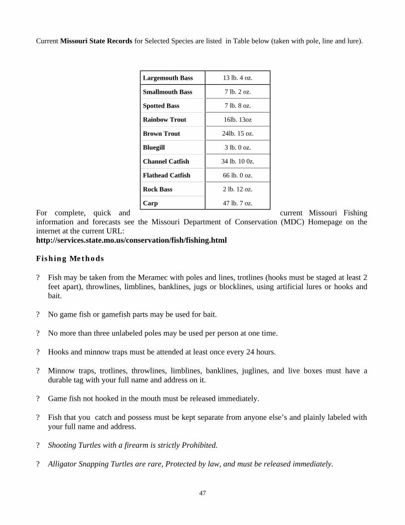
49
Current Missouri State Records for Selected Species are listed in Table below (taken with pole, line and lure).
For complete, quick and current Missouri Fishing information and forecasts see the Missouri Department of Conservation (MDC) Homepage on the internet at the current URL: http://services.state.mo.us/conservation/fish/fishing.html Fishing Methods ? Fish may be taken from the Meramec with poles and lines, trotlines (hooks must be staged at least 2
feet apart), throwlines, limblines, banklines, jugs or blocklines, using artificial lures or hooks and bait.
? No game fish or gamefish parts may be used for bait. ? No more than three unlabeled poles may be used per person at one time. ? Hooks and minnow traps must be attended at least once every 24 hours. ? Minnow traps, trotlines, throwlines, limblines, banklines, juglines, and live boxes must have a
durable tag with your full name and address on it. ? Game fish not hooked in the mouth must be released immediately. ? Fish that you catch and possess must be kept separate from anyone else’s and plainly labeled with
your full name and address. ? Shooting Turtles with a firearm is strictly Prohibited. ? Alligator Snapping Turtles are rare, Protected by law, and must be released immediately.
Largemouth Bass 13 lb. 4 oz.
Smallmouth Bass 7 lb. 2 oz.
Spotted Bass 7 lb. 8 oz.
Rainbow Trout 16lb. 13oz
Brown Trout 24lb. 15 oz.
Bluegill 3 lb. 0 oz.
Channel Catfish 34 lb. 10 0z.
Flathead Catfish 66 lb. 0 oz.
Rock Bass 2 lb. 12 oz.
Carp 47 lb. 7 oz.
47
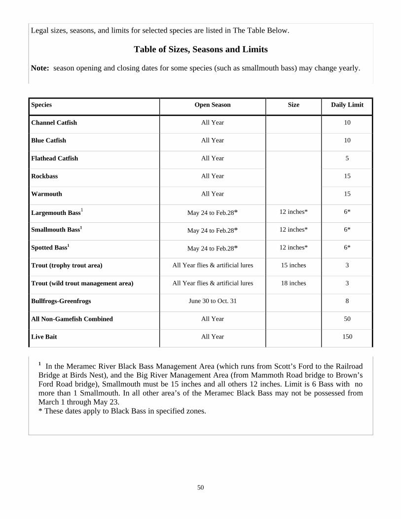
50
Species Open Season Size Daily Limit
Channel Catfish All Year 10
Blue Catfish All Year 10
Flathead Catfish All Year 5
Rockbass All Year 15
Warmouth All Year 15
Largemouth Bass1 May 24 to Feb.28* 12 inches* 6*
Smallmouth Bass1 May 24 to Feb.28* 12 inches* 6*
Spotted Bass1 May 24 to Feb.28* 12 inches* 6*
Trout (trophy trout area) All Year flies & artificial lures 15 inches 3
Trout (wild trout management area) All Year flies & artificial lures 18 inches 3
Bullfrogs-Greenfrogs June 30 to Oct. 31 8
All Non-Gamefish Combined All Year 50
Live Bait All Year 150
1 In the Meramec River Black Bass Management Area (which runs from Scott’s Ford to the Railroad Bridge at Birds Nest), and the Big River Management Area (from Mammoth Road bridge to Brown’s Ford Road bridge), Smallmouth must be 15 inches and all others 12 inches. Limit is 6 Bass with no more than 1 Smallmouth. In all other area’s of the Meramec Black Bass may not be possessed from March 1 through May 23. * These dates apply to Black Bass in specified zones.
Legal sizes, seasons, and limits for selected species are listed in The Table Below.
Table of Sizes, Seasons and Limits Note: season opening and closing dates for some species (such as smallmouth bass) may change yearly.

51
Sponsors
The businesses/organizations on the following pages offer quality,
concerned river access and recreation related services, they deserve honorable mention (and
your patronage) for their contributions toward the
publication of this text.
How To Come Enjoy It!

52
“At Blue Springs Ranch we are dedicated to providing high quality river access and utilization services, in harmony with the principles of protection, preservation, and management of our natural resources. Through proper respectful treatment of the Meramec river we can insure profitable, pleasurable usage for present as well as future generations”.
-JR Isom- Services: ? DELUXE CABINS (WOODED SETTING). ? CAMPING (RV AND TENT SITES). ? FLOATING : CANOES, 2, 4, 6, 8 AND 10 MAN RAFTS AND INNER-TUBES. ? HAYRIDES ? HORSEBACK TRAILRIDES ? SWIMMING-POOL ? CATERING ? PAVILION. LARGE GROUPS WELCOME!
FOR MORE INFO. CALL: 1-800-333-8007 OR 1-573-732-5200.
Services: ? Country Store ? Campgrounds ? Canoe Rentals ? Cabins ? Dining Lodge Restaurant ? Raft Trips
? Banquets ? Catering ? Barbeques ? Company Conference
Center - With Lodging Available
? Motel
For Reservations call: Doyle & Vicki Isom, Concessionaires.
573-468-6519 or 573-468-3632 or 1-800-334-6946
I-44 to Hwy. 185 South at Exit 226, 4 miles from I-44, Sullivan, Mo. 63080.

53
“Because this farm has been in the family since 1811, our heritage is deeply rooted in the river, presently, our concerns revolve around appreciation for the natural beauty of this stream & area, and its continued existence for the delight and appreciation of future generations.”
- Carol Springer - Services : ? LODGING (CABIN OR OVERNIGHT ROOMS). ? FARM FARE:(MEALS FEATURE FRESH-BAKED BREADS, FARM RAISED FRUITS, VEGETABLES AND
MEATS). ? NATURE TRAILS ? 5 ACRE GRAVEL BAR ? GUIDED HORSEBACK RIDES: (BARN SPACE AVAILABLE FOR YOUR HORSE). FOR MORE INFORMATION CALL: CAROL SPRINGER AND DAVID CURTIS (573) 732-4765. OR EMAIL: [email protected]
”Respect and appreciation of the river - along with providing quality services -
are our main concerns.” - Robert Bass-
Ozark Outdoors
& Keyes Canoe
Leasburg, MO.
Services: ? FLOATS AVAILABLE ON THE MERAMEC RIVER AND COURTOIS-HUZZAH CREEKS. ? A LARGE VARIETY OF CRAFTS: CANOES - ALUMINIUM OR FIBERGLASS, RIVER RAFTS - 2, 4, 6, 8, 10,
12, OR 14 MAN, KAYAKS, INNER TUBES AND JON BOATS. ? RIVERFRONT CAMPING ? CABINS ? RV CAMPING ? CATERED COOKOUTS. ? SWIMMING POOL ? LARGE GROUPS WELCOME!

54
“It’s easy to appreciate the natural beauty of Missouri as you pass through an ever-changing panorama of bluffs and valleys, teeming with beautiful plant and wildlife. There’s no better way to experience the perfection of the Meramec valley than on the ancient and wonderful river itself — from a canoe, a raft, a good old inner tube or a riverside campsite.”
- Linda Fagan - P.O. BOX 796 - THURMAN LAKE ROAD -
STEELVILLE, MO. 65565 Services: ? Canoes, Rafts, Jon Boats, Tubes. ? Riverfront Camping, Group Campsites, Outings, Rates. ? Hot Showers - Concession Stand ? Barbeques and Steak Cookouts ? Private Shuttle Service ? Trophy Trout and Bass Fishing ? Area Attractions: Historic Maramec Spring Park, Ironworks and Trout Hatchery...Meramec Country
Music Show...World-Class Antique and Gift Shopping...Wineries...Caves...Hiking and Biking Trails.
For more info call: 1-800-324-2674 or 1-573-775-5744 ? Visit our Web site: http://www.misn.com/~fagans/
“We are very proud of this river and area,
and strive to maintain the stretch we service, for our own as well as our clients’ present
and future use and enjoyment”. - Mark Garrison -
Services: ? CANOES - RAFTS - JON BOATS - INNER TUBES. ? FLOATS AVAILABLE ON THE MERAMEC RIVER
AND COURTOIS-HUZZAH CREEKS. ? LODGING: CAMPING CABINS - COTTAGES - RV UNITS - RIVER BLUFF CABINS - RANCH HOUSES. ? CAMPING: 160 RV SITES, 200 TENTSITES, - ALL GROUPS WELCOME. ? HORSEBACK TRAILRIDES ? REAL WEST ADVENTURES -EXTRA VALUE PACKAGES -

55
Bourbon RV Center
Hardware &
Camping Supplies
A full range provider of all your RV needs.
Sales - Service - Parts - Accessories
On I-44 at Bourbon Exit (Exit 218).
1-800-343-5795
ReedCraft Boat Mfg. Inc.
Factory Direct or Custom Built Boats.
Full Range Providers of Your Boating Needs.
OUTDOOR SPORTS
I-44 N. Service Rd.
Sullivan, Mo.
(573) 468-8176
OUTDOOR SPORTS
Hwy V & I-44
Rt. 66 N Rolla, Mo.
(573) 364-1125
PERRY’S MARINE
1232 W. Springfield
Union, Mo.
(314) 583-7777
OUTDOOR SPORTS
356 Hwy HH,
Piedmont, Mo. 63957
(573) 223-2646
OUTDOOR SPORTS
Hwy 67 North, Rt.
6 Box 424. Poplar Bluff Mo.
(573) 686-3773

56
Bourbon Family Center Variety Store
& True Value Hardware
Help Is Just Around The Corner.
? Liquor and Beverages ? Missouri Lottery ? Hunting and Fishing Permits ? Hunting - Fishing - Camping Supplies ? Missouri Conservation Dept. Check-Station
Hours: MON-THURS 8:30-9. FRI-SAT 8:30-10. SUN 10:00-6.
Bourbon Plaza Shopping Center
P.O. Box 7 Bourbon, Mo.
65441 573-732-5517
Scoops ‘N’ Snacks Ice Cream Parlor & Deli. 16 flavors hand-dipped
573-732-5991
Plaza Car Wash &
Storage
I-44 ONE-STOP
? GAS ? DIESEL ? DELI ? GROCERIES ? BEER ? LIVE BAIT
I-44 & NORTH SERVICE ROAD
BOURBON, MO. 573-732-5907

57
CALL COLDWELL BANKER
SUPPORT YOU CAN COUNT ON
FOR OVER 90 YEARS
(314) 629-1048 780 N. Commercial Ave. - St. Clair
(314) 239-6741 1035 Washington Sq. - Washington
(573) 437-4111 411 E. Hwy. 28 - Owensville
(314) 583-6514 Union
Ralph’s O.K. Service &
Flea Market
Over Thirty Years of Service.
“We must take care of the river, so it will always be there for the enjoyment of all”. - Ralph Breese -
? Tire Service ? 24 hr Towing (Local or Long Distance) Towing: 573-732-4451 Pager: 800-501-3908 In Truck: 573-440-9717 Nights: 573-468-3171 or 573-860-2116
Located in Bourbon, Mo.
-FARMS-
-RESIDENTIAL-
-ACREAGE-
-COMMERCIAL-
? GOLD KEY REALTORS of Coldwell Banker
Residential Affiliates, Inc.
? Expect the best.
MULTIPLE LISTING SERVICE
MLS EQUAL HOUSING
OPPORTUNITY ? REALTOR

58
Services We Provide ? Computer Diagnostics ? Fuel and Ignition Service ? Tune-Ups ? Brakes and Shocks ? Complete Exhaust Repair ? Foreign & Domestic Cars
? Heating & Air Conditioning Service & Retrofit ? General Engine Repair ? Suspension & Steering Repair ? MO. State Safety Inspection
? Electrical System Repair AAA Approved
ASE Certified Mechanics
Trained Service Tech. Auto Care Center
Jim’s Auto Repair Complete Auto Service
James S. Bell Owner
573-732-5307 Bourbon, MO. 65441
RIVERSIDE REPTILE RANCH
A Hands-On Live Reptile Adventure! Plus The Jesse James Trading Post and Gift Shop!
Unusual Souvenirs , One-Of -A Kind Gifts, Memorabilia, Knives, Jewelry, Handmande Native American Onyx and Turquoise Jewelry, Pottery, Blankets And Much More!
Get your picture taken with one of our reptile
friends!
275 Hwy W & Twin Springs Rd. P.O. Box 117 Stanton, MO. 63079
(573)92-SNAKE OR (573)-927-2700

59
Courtois - Huzzah - Meramec River Floats Canoes - Rafts - Kayaks Inner Tubes
?Riverfront Camping ?RV Sites ?Lodging ?Trailrides ?Campstore
1-800-392-3700 Steelville, MO.
Lots Of Pure FDIC
“Fun Down In The Country”.
Huzzah Valley Campground - Canoe Rental.
Missouri’s Most Complete Resort.
? Float on the Courtois-Huzzah or Meramec. ? Canoes-Rafts-Kayaks-Inner Tubes ? Riverfront Camping ? Lodging ? Trailrides ? Campstore ? Huzzah Club Dining & Entertainment
Steelville, MO.

60
Date arrived: Days camped:
Participants:
Put in: Type of Craft:
Take out: Miles floated: Trip time(hours):
Items/supplies forgotten:
Suggested items/supplies next trip
Notes:
Type of trip(float-camp-fish-etc):
Trip Records
The following spaces are provided for your convenience should you want to keep a record of your trips. A permanent record of trips taken could prove to be very helpful in planning for future trips and will help preserve the remembrances and nuances of your experience.

61 59
Date arrived: Days camped:
Participants:
Put in: Type of Craft:
Take out: Miles floated: Trip time(hours):
Items/supplies forgotten:
Suggested items/supplies next trip
Notes:
Type of trip(float-camp-fish-etc):
Date arrived: Days camped:
Participants:
Put in: Type of Craft:
Take out: Miles floated: Trip time(hours):
Items/supplies forgotten:
Suggested items/supplies next trip
Notes:
Type of trip(float-camp-fish-etc):

62
Date arrived: Days camped:
Participants:
Put in: Type of Craft:
Take out: Miles floated: Trip time(hours):
Items/supplies forgotten:
Suggested items/supplies next trip
Notes:
Type of trip(float-camp-fish-etc):
Date arrived: Days camped:
Participants:
Put in: Type of Craft:
Take out: Miles floated: Trip time(hours):
Items/supplies forgotten:
Suggested items/supplies next trip
Notes:
Type of trip(float-camp-fish-etc):

63
Endnotes
1. Bill Crawford, “The Meramec - St. Louis Playground”, ’Rivers of Missouri’, Tribune, Jefferson City: 1949. 19 2. Bill Crawford, “The Meramec - St. Louis Playground”, ’Rivers of Missouri’, Tribune, Jefferson City: 1949. 19. James E. Vandike, “The Hydrology of Maramec Spring”, Brochure produced by James Foundation in cooperation with the Missouri Dept of Natural Resources. St. James, Mo. 3. St. Louis Post Dispatch, 13 July 1925. Jefferson County Republican 18 October 1907. Robert L. Ramsey, “Jefferson County Place Names”, Bulletin of the Missouri Historical Society. Vol. X, 1953 4. James P. Jackson, “Passages of a Stream - A Chronicle of the Meramec”, University of Missouri Press, Columbia: 1984. 5-58 5. Ibid.. 6. Ibid. P-11 7. Ibid. P-14 8. James P. Jackson, “Passages of a Stream - A Chronicle of the Meramec”, University of Missouri Press, Columbia: 1984. 5-58. James E Vandike, “The Hydrology of Maramec Spring”, Brochure produced by James Foundation in cooperation with the Missouri Dept. of Natural Resources. St. James, Mo. 9. Ibid.p-19 10—17. Ibid . 18. James P. Jackson, “Passages of a Stream - A Chronicle of the Meramec”, University of Missouri Press, Columbia: 1984. 5-58. John E. Rothensteiner, “Earliest History of Mine La Motte”, Missouri Historical Review, Vol. XX, January 1926. 199-213. Department of the Interior, Bureau of Outdoor Recreation, National Park Service, “Meramec River Basin”. October 1969. 36,37. 19. ’Pirogue’ - A crudely canoe shaped hollowed out log, (Websters Dictionary). ’Flatboat’ - A crude, boxy, flat-bottomed boat, up to fifty feet in length and twelve feet in width, usually could not return upstream, and were broken up and sold as lumber at the destination.’Keelboat’ - similar to flatboat but shaped for less water resistance, could make trips upstream, cigar shaped with a length to width ratio of four to one or narrower, a heavy keel ran down the center of the length of the boat, especially at the prow to take the brunt of collisions with obstacles under the water. ( Edith McCall, “Conquering the Rivers, Henry Shreve and the Navigation of America’s Inland Waterways”, Louisiana State University Press, Baton Rouge: 1983. 2, 12, 20.) 20. William R. Draper, “History of the Old Mines in Meramec Park”, Missouri Historical Review, Vol. XXIII, January 1929. 348-349 . 21. John E. Rothensteiner, “Earliest History of Mine La Motte”, Missouri Historical Review, Vol. XX, January 1926. 201, 208, 209, 211. Historical Edition of the Farmington News, October 14, 1927. “Missouri’s Lead Mining District”, Missouri Historical Review, Vol. XXII. 274 22. William R. Draper, “History of the Old Mines in Meramec Park”, Missouri Historical Review, Vol. XXIII, January 1929. 348-349.

64
23. Ibid. 24. Floyd C. Shoemaker, “Herculaneum Shot Tower”, Missouri Historical Review, Vol. XX, January 1926 214-216. Jonas Viles “Missouri in 1820", Missouri Historical Review, Vol. XV, October 1920. 40. Henry R. Schoolcraft, “Mines of the West”, Chas Whiley, New York: 1819. 57. 25. Floyd C. Shoemaker, “Herculaneum Shot Tower”, Missouri Historical Review, Vol. XX, January 1926. 214-216. 26. Henry R. Schoolcraft, “Mines of the West”, Chas Whiley, New York: 1819. 57 The Crane Chronicle, April 10, 1930, “Ashley’s Cave”. Missouri Historical Review, Vol. XXIV, July 1930. 608. 27. James P. Jackson, “Passages of a Stream - A Chronicle of the Meramec”, University of Missouri Press, Columbia: 1984. 49 28. James P. Jackson, “Passages of a Stream - A Chronicle of the Meramec”, University of Missouri Press, Columbia: 1984. 49-58 29. James D. Norris, “Frontier Iron, The Maramec Iron Works”, State Historical Society of Wisconsin, Worzalla Publishing, Steven's Point: 1964. 13, 22, 96-102. 30—31. —32. Ibid. 33. James P. Jackson, “Passages of a Stream - A Chronicle of the Meramec”, University of Missouri Press, Columbia: 1984. 49- 58. A Missourian of 20 years standing in the State, “Meramec River Navigation Improvement”, Western Journal and Civilian, Vol. 5, Moritz Niedner: 1851. 192. 34. James P. Jackson, “Passages of a Stream - A Chronicle of the Meramec”, University of Missouri Press , Columbia: 1984. 49-58, 59-82, 108-123. 35. —40.Ibid. 41. Ibid. P-107 42. Bill Kammer, “From my own experience as a resident of the upper Meramec region for 16 years, and my experiences as a professional canoe liveryman for 15 years” . 43. Leland D. Baldwin, The Keelboat Age on Western Waters. University of Pittsburg Press,1941. 41 44. Michael McCafferty, Center for Latin American and Caribbean Studies, Indiana University Bloomington, Indiana. In email letters to Bill Kammer - Friday, June 13, 2003. Michael is an Algonquian linguist and specialist in the Miami-Illinois language, and an expert in Algonquian place names/river names in the Midwest. 45. Michael McCafferty, Center for Latin American and Caribbean Studies, Indiana University Bloomington, Indiana. In email letter to Bill Kammer – Monday, July 14, 2003. Michael is an Algonquian linguist and specialist in the Miami-Illinois language, and an expert in Algonquian place names/river names in the Midwest.

65
PHOTO ALBUM

66

67

68

69

70

71

72

73

74

75
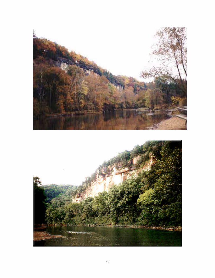
76

77

78
Respect Our Space
Stash Your Trash
Leave No Trace