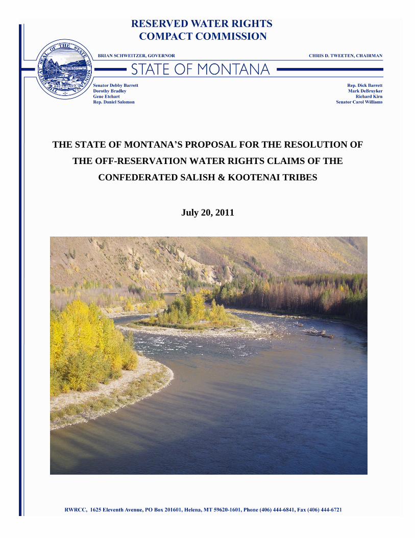
the state of montana s proposal for the resolution …
TRANSCRIPT
July 20, 2011
State of Montana Proposal 1
THE STATE OF MONTANA’S PROPOSAL FOR THE RESOLUTION OF
THE OFF-RESERVATION WATER RIGHTS CLAIMS OF THE
CONFEDERATED SALISH & KOOTENAI TRIBES
July 20, 2011

July 20, 2011
State of Montana Proposal 2
INTRODUCTION
The State of Montana (State) through the Montana Reserved Water Right Compact
Commission (Compact Commission), the Confederated Salish and Kootenai Tribes (Tribes) and
the United States are attempting to settle, through negotiation rather than litigation, the Tribes’
water rights claims in the State of Montana. Among these claims, are ones for non-consumptive
off-reservation uses to preserve the Tribes’ right, recognized in the 1855 Treaty of Hell Gate, to
tak[e] fish …in common with citizens of the Territory.”1 Language in similar treaties in the
Pacific Northwest have been interpreted to secure to tribes protectable rights in stream flows and
other aspects of water rights to ensure that the right to take fish means more than simply the
ability to dip a net into the water and have it come out empty.2
Consistent with the Compact Commission’s task of reaching a quantification agreement
concerning the Tribes’ water rights that both appropriately recognizes the scope of those rights
and also accords meaningful protections to existing water users, and with an eye toward reaching
accord on off-reservation rights at a level that provides for tangible biological benefits to the
affected fisheries and ecosystems and recognizes the State’s need for management flexibility in
basins that are not wholly appropriated, the Compact Commission has worked closely with
Montana Fish, Wildlife & Parks (FWP) and the Department of Natural Resources and
Conservation (DNRC) to identify mechanisms to provide meaningful instream flow protections
that could be recognized in a Compact for streams outside the boundaries of the Flathead Indian
Reservation where the State believes the Tribes have both significant interest and colorable legal
claims. These streams include the Kootenai River, the Swan River, the Bitterroot River, the
Flathead River system above Kerr Dam, and the Upper Clark Fork River (the drainage area
above Missoula, MT). For the mainstem of the Kootenai and Swan Rivers, the Compact
Commission proposes recognizing water rights with time immemorial priority dates and with one
or more enforceable hydrographs set at a level appropriate to providing the biological benefits,
protections to existing users and management flexibility referenced above. For the remainder of
1 Treaty of Hell Gate, Article 3: “The exclusive right of taking fish in all the streams running through or bordering
said reservation is further secured to said Indians; as also the right of taking fish at all usual and accustomed places,
in common with citizens of the Territory, and of erecting temporary buildings for curing; together with the privilege
of hunting, gathering roots and berries, and pasturing their horses and cattle upon open and unclaimed land.” 2 See, e.g., United States v. Washington, 506 F.Supp. 187, 203 (W.D.Wash.1980); United States v. Adair, 723 F.2d
1394 (9th Cir. 1983).

July 20, 2011
State of Montana Proposal 3
the identified rivers, the State is firmly convinced that a simple recognition in these streams of a
non-consumptive right for the Tribes with a time immemorial priority date does not provide the
basis for a viable negotiated settlement. However, the State believes that the approach described
below is capable of providing the Tribes with meaningful instream flows for these streams in a
manner that will allow the settlement to move forward in the Montana legislature.
The State also requests that this proposal also be viewed in light of the stream flow
protections that already exist on numerous streams and reaches in western Montana, which
individually and collectively provide important context for the analysis of the Tribes’ claims to
off-reservation water rights. These existing protections are depicted on the map attached hereto
as Appendix A. They include protections on 63 streams in the Kootenai River basin, 107
streams in the Flathead River basin (a number which excludes those existing protections for
streams within the Flathead Indian Reservation), 86 streams in the Upper Clark Fork basin and
157 streams in the Lower Clark Fork basin. These protections are provided through a variety of
mechanisms that include quantification points and stream reaches protected through the National
Park Service-Montana and US Forest Service-Montana water rights compacts, instream flow
leases held by FWP, and instream flow and recreation water rights claims filed by FWP in
Montana’s general stream adjudication. Additionally, the Upper Clark Fork basin above
Missoula and the Bitterroot basin have been closed to new appropriations by the Montana
legislature.
DRAINAGE BY DRAINAGE APPROACHES
The Kootenai –
In some ways, the Kootenai River drainage is the most straightforward basin for
recognizing the Tribes’ off-reservation rights, as the existing consumptive uses in that drainage
are small compared to the volume of water available. Consequently, the State proposes to
recognize a tribal instream flow right in the mainstem of the Kootenai River with a time
immemorial priority date. At the same time, determining the optimal way to describe this right,
the reach or reaches of the river it will protect, and how it can best be enforced, is complicated
by the fact that the double-peak operations of Libby Dam essentially reverse the natural
hydrograph by storing water during the spring runoff and releasing water during the cold months
July 20, 2011
State of Montana Proposal 4
for power generation and flood risk management. Thus the State is not proposing to use current
flow conditions as a baseline for establishing the Tribes’ for-all-time water right. At the same
time, those operations have been dramatically improved over the past 5-7 years by the
development and implementation (starting in 2009) of the Mainstem Amendments (or Montana
Operations) included in the 2008/2010 Supplemental Biological Opinion (BiOp) for the Federal
Columbia River Power System (FCRPS) that is currently in litigation before Judge Redden in
Portland. The State and the Tribes have both invested significant time and resources in
defending that BiOp and in advocating for the Mainstem Amendments, and the State is unwilling
to do anything in this settlement that undercuts that effort.
Consequently, the State suggests that the parties direct the Joint Technical Team (JTT) to
look at ways that an enforceable hydrograph of a tribal Kootenai River instream flow right with a
time immemorial priority date could be defined to account both for current constraints and
subsequent changes over time when, for example, FCRPS operations are improved for the
benefit of native Montana species and/or there is a renegotiation of the Columbia River Treaty
encompassing other improved opportunities. The State will provide an option to the JTT for its
consideration that meets these objectives. The State option will describe a tribal Kootenai
instream flow right that also retains the DNRC’s authority to permit new water uses in the
Kootenai River basin (recognizing that such junior uses might not be able to be satisfied every
year, but at least in wet and average conditions).
Kootenai Tributaries–
In addition to this mainstem water right, the State proposes making the Tribes co-owners
with FWP of FWP’s filed use right claims on the Tobacco River and Young Creek, both
tributaries to the Kootenai River. Appendix B summarizes the attributes of these claimed rights.
These claims on both the Tobacco River and Young Creek were included in the Water Court’s
March 1984 Temporary Preliminary Decree on Kootenai River, Basin 76D. These claims were
also recognized in Judge Holter's decision in Case 76D-48 and 75D-49. In that decision, Judge
Holter ruled that the maintenance of public fisheries is a beneficial use in Montana and was
before July 1, 1973, and that FWP’s claims for instream fish and wildlife purposes on Young
Creek and the Tobacco River are for beneficial uses for valid appropriations of water. (He
additionally held that the construction and maintenance of fish ladders, fish traps and passage

July 20, 2011
State of Montana Proposal 5
facilities constitute an appropriation by diversion.) Between a time immemorial mainstem right
and co-ownership of the FWP recreation rights, the State believes that the Tribes interests in the
Kootenai River drainage will be fully recognized and protected.
The Swan –
While consumptive uses take up a larger percentage of the available water supply in the
Swan than the Kootenai, the Swan River drainage offers the added flexibility of being less
directly impacted by dam operations than the Kootenai. Although the Swan is a tributary to the
Flathead, it is not as major a contributor to FCRPS operations as the Kootenai. Thus the State
proposes a similar approach in the Swan as in the Kootenai–that is, to recognize a tribal instream
flow right with a time immemorial priority date in the mainstem of the Swan that: 1) provides
biological benefits to the ecosystem; 2) protects existing uses; and 3) preserves for the DNRC the
ability to permit some new uses that could be satisfied at least in above average water years.
Again, the State will provide an option to the JTT for its consideration that meets these
objectives. It is worth noting that the largest existing rights are the non-consumptive rights for
hydropower held by the Pacific Power & Light Co. As they are non-consumptive, Pacific
Power’s rights would not conflict with the right we are proposing to recognize for the Tribes.
The Bitterroot –
In contrast to the Kootenai and Swan River drainages, the Bitterroot drainage presents a
much more complicated picture. As early as 1947, the United States Department of
Agriculture’s Soil Conservation Service (now named the Natural Resources Conservation
Service) identified significant shortages in water supply for then-existing irrigation.3
Recognition of a senior instream flow right for the Tribes in the Bitterroot would thus be too
disruptive of existing uses to be a reasonable part of a negotiated settlement. Nonetheless, FWP
possesses contracts for the delivery of specified volumes of water from two storage facilities in
the Bitterroot drainage for instream flows, along with additional claims filed in Montana’s
general stream adjudication. The State proposes to make the Tribes co-owners, with FWP, of
those rights as a means of providing the Tribes with recognized instream flow protections in this
3 See “Reconnaissance Conservation Report on Water Control, Use and Disposal, Bitterroot River Drainage Basin,”
USDA Soil Conservation Service, April 1947.
July 20, 2011
State of Montana Proposal 6
drainage. The specifics of how such co-ownership will be administered and protected would be
a subject for further negotiation.
FWP has three contracts for stored water that it uses to augment Bitterroot River
mainstem flows. One contract is a life-of-the-project contract from Painted Rocks reservoir for
10,000 acre-feet to be delivered during the summer and fall.4 Under the terms of this agreement,
FWP is entitled to a 10,000 acre-foot allocation (or, if that much water was not available, 40% of
the stored water delivered at the reservoir outlet). This stored water is available for release
between May 1 and September 30th
of each year. The term of this contract is for the useful life
of the Project, as extended by any repairs and rehabilitation. FWP has a second agreement with
DNRC, dated March 5, 1958,5 for an additional 5,000 acre-feet of stored water from Painted
Rocks. The third FWP agreement is with the Bitter Root Irrigation District for a maximum of
3,000 acre feet of water out of Lake Como (the exact amount depends on annual snowpack and
stream flow conditions), used primarily to supplement river flows during the fall.6 Adding the
Tribes to these agreements as a co-party with FWP or through some other sort of shared-right-of-
exercise arrangement would afford the Tribes a significant mechanism for achieving flow
protection goals in the Bitterroot drainage.
In addition, FWP’s filed rights include 12 claims for public recreation uses for the
Bitterroot River. Appendix C summarizes the attributes of these claimed rights. As the public
recreational use is primarily fishing (as well as recreational floating), the flow rates and volumes
asserted for these claims were determined by reference to the conditions necessary to support
fish habitat. Recreational right claims were authorized under a section of Senate Bill 76 enacted
during the 1979 legislative session, now codified at 85-2-223, MCA. The statute provided,
however, that it was not to be construed as a legislative determination of whether claimed pre-
1973 recreation uses constituted beneficial use under the laws of Montana in place prior to 1973
(a necessary component of a valid water rights claim).7 Nevertheless, FWP intends to assert and
defend these claims vigorously in Montana’s general stream adjudication. The State recognizes
that claimed priority dates for these water rights, 1970, is very junior, which limits the absolute
4 See “FWP Water Purchase Contract Painted Rocks, between FWP and DNRC,” July 12, 2004 (attached hereto as
Appendix G). 5See “Water Purchase Contract,” March 5, 1958 (attached hereto as Appendix H).
6 See “Agreement Between the Bitterroot Irrigation District and the United States Department of the Interior, Bureau
of Reclamation for the Operation of the Enlarged Storage Pool at Lake Como,” July, 1994 (attached hereto as
Appendix I). 7 85-2-332 MCA (2009).

July 20, 2011
State of Montana Proposal 7
value of these rights. However, sharing ownership of these claims with the CSKT offers another
mechanism for meeting the Tribes’ goals for instream flow protections in the Bitterroot
drainage.8
The Flathead Basin –
For the purposes of this proposal, the Flathead Basin includes the Flathead River and its
tributaries above Kerr Dam, excluding the Swan River, which is dealt with separately above.
The North, Middle, and South Forks of the Flathead River, Stillwater and Whitefish River
drainages are included in this portion of the proposal. Much of the flows of the Flathead Basin
are determined by the operations of Hungry Horse and Kerr dams. Flow regimes established by
the Flathead Lake Level Management Plan and the FCRPS BiOp provide significant protective
flows on the mainstem of the Flathead River. In addition, the proposed changes to Hungry Horse
allocations and operations that are being contemplated in these negotiations have the potential to
augment fishery and ecological flows if the Tribes so choose. Consequently, the Compact
Commission believes the Tribes’ interests in this basin are largely well protected.
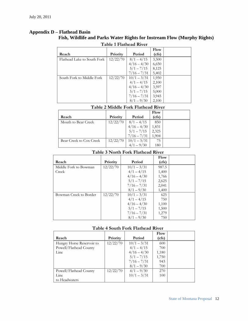
That said, FWP also has instream flow water rights (Murphy Rights9) on the Flathead
River above Flathead Lake, as well as on multiple reaches of the North, South and Middle Forks
of the Flathead River. The reaches, priority dates, periods and flows of these claims are
presented in Appendix D. FWP has also asserted two water rights in association with Rogers
Lake. (Rogers Lake lies at the headwaters of Sickler Creek which is a headwaters tributary of the
Little Bitterroot River.) One is an in-lake claim for Fish and Wildlife purposes asserting a
volume of 922 acre feet and a minimum lake pool.10
The second claim asserts a 4 cfs instream
flow use with a 1920 priority date on the inflows to Rogers Lake.11
The State recommends
making the Tribes co-owners, with FWP, of those rights as a means of providing additional
instream flow protections in this basin. As also noted above, the specifics of how such co-
ownership will work in the administration and protection of these rights are a subject for further
negotiation.
8 To be clear, however, in proposing co-ownership of water rights the State is not suggesting an approach that
includes affording the Tribes shared authority in the off-reservation management of species or the off-reservation
regulation of fishing and hunting (something that no court has interpreted a treaty right to include). 9 “Murphy Rights” is the colloquial term for instream flow rights authorized by the Montana legislature in section
85-801, R.C.M. 1947 (1969). 10
Statement of Claim for Existing Water Rights Other Uses – Fish and Wildlife, 76L 18681 00. 11
Statement of Claim for Existing Water Right Other Uses – Fish and Wildlife, 76L 18680 00.
July 20, 2011
State of Montana Proposal 8
The Upper Clark Fork –
The centerpiece of the State’s proposal for the Upper Clark Fork basin is to grant the
Tribes co-ownership, with FWP, of the water rights formerly associated with the Milltown Dam.
Those rights have passed to the State’s ownership as part of the resolution of the natural
resources damages claims brought against the Atlantic Richfield Company and Northwestern
Energy, in the Milltown consent decree, to which the Tribes are a party.12
It is anticipated that
FWP will be the State agency designated to manage those rights for instream flow purposes. The
specific parameters of this transfer, how the purpose of these rights will be changed from
hydropower to instream flow, and how these rights will be exercised in the future are all subjects
for further negotiations if the Tribes are open to exploring this option as a way of resolving their
off-reservation claims in this basin. The direct flow hydropower right associated with Milltown
asserts a diversionary demand for 2,000 cfs as the maximum flow through the facilities turbines,
with a priority date of December 11, 1904. This priority date and the volume of water associated
with this right make it a notable senior right in the basin. Thus this right potentially has the
ability to be utilized to afford significant instream flow protections for the mainstem of the Clark
Fork River.
An important consideration in the administration of these rights, however, is their
potential for disruptive impacts upstream of the former Milltown Dam, particularly on Clark
Fork tributary streams. To ensure a workable solution, a plan for minimizing the impacts from
an exercise of the Milltown rights in strict priority is a necessary component of this proposal. In
general terms, we envision establishing specific flow targets for various Clark Fork tributaries.
These targets would identify both the flow needs of that given watershed or stream reach and the
expected flow contribution of a drainage based upon its size and hydrology. Based on our
review of the existing stream flow data, we believe that appropriately set targets can ensure that
the Milltown Rights can be satisfied in a biologically productive manner while allowing
individual watersheds or reaches to continue their historic water management efforts–so long as
they incorporate and meet their individualized flow target. This sort of adaptive management
approach has been employed with much success on the Blackfoot River, though the specific flow
12
United States of America v. Atlantic Richfield Company and Northwestern Corporation, Civil Action No. CV89-
039-BU-SHE.

July 20, 2011
State of Montana Proposal 9
targets and any enforcement mechanism for them here are subjects for further negotiations. The
effort to utilize the Milltown rights in connection with a CSKT-Montana Compact will likely be
controversial, requiring careful consideration and extensive public outreach. The State does not
identify these factors to suggest that using the Milltown rights in the way suggested above is
unadvisable, but rather simply to be clear that it is an issue that will be watched particularly
closely by the interested public.
In any event, in addition to co-ownership of the Milltown Dam rights, the State also
proposes to make the Tribes co-owners, again with FWP, of FWP’s existing water rights claims
in the Upper Clark Fork Basin, specifically on the Clearwater and Blackfoot Rivers. (FWP has
no existing water rights claims on the mainstem of the Clark Fork River.) These rights were
filed in the adjudication as either Murphy Rights or Public Recreational Use Claims. The
Murphy Rights claims were filed for two mainstem reaches of the Blackfoot River and two
reaches of Rock Creek, a major tributary near Clinton, Montana. Streams with associated
Murphy Right Claims in the Upper Clark Fork Basin include are described in Appendix E. The
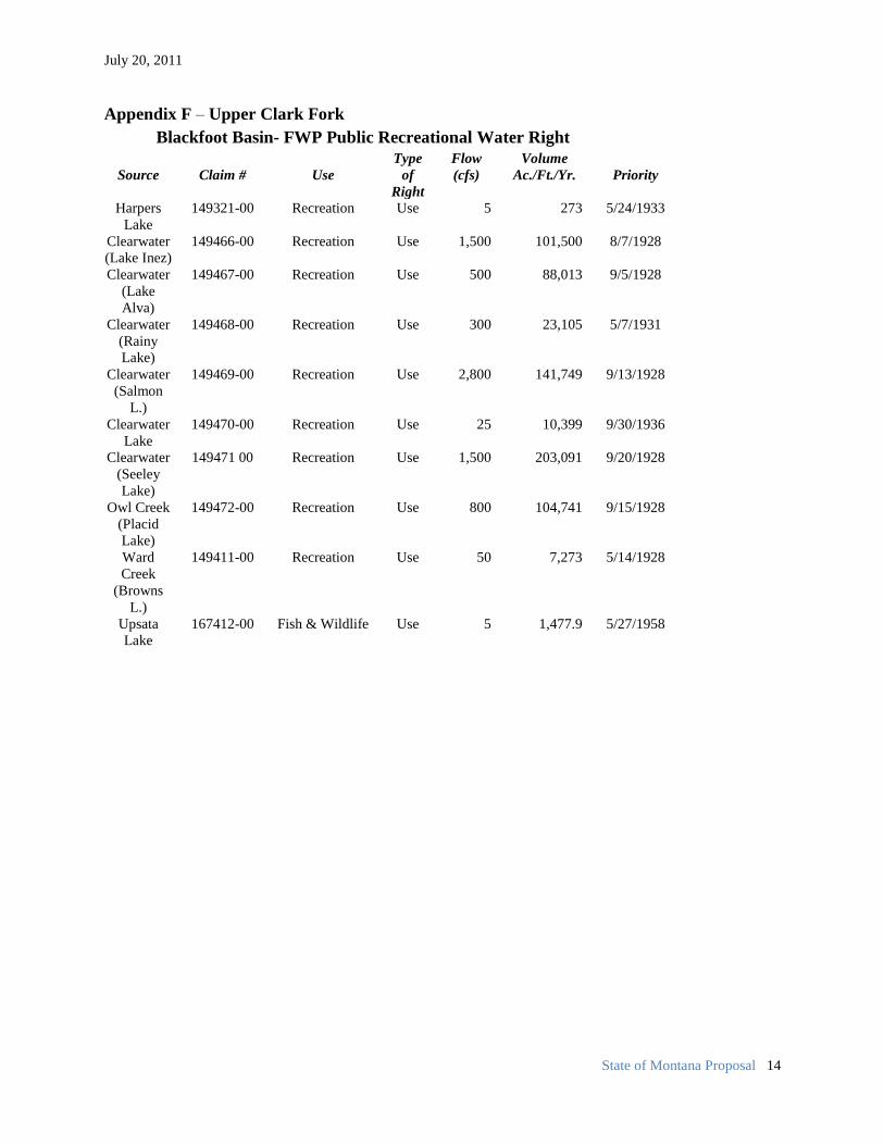
Public Recreation Use claims were filed in the Blackfoot sub-basin. See Appendix F. These
claims are all filed on lakes, all but two of which (Browns and Upsata Lake) are in the
Clearwater River drainage. As the public recreational use is primarily fishing, the flow rates and
volumes asserted for these claims were determined by reference to the conditions necessary to
support fish habitat.
The State believes that the combination of the significant mainstem protections that the
Milltown Rights could afford with FWP’s filed claims in the Blackfoot and Clearwater provide a
sound mechanism for vindicating the Tribes’ goals in the Upper Clark Fork drainage in a
negotiated settlement.
CONCLUSION
The State recognizes that this proposal leaves many important details to be filled in,
particularly the identification of appropriate flow targets on the Kootenai and Swan Rivers, and
the development of the method or methods through which the Tribes and FWP would co-own
and co-exercise the various rights identified above. We have chosen this approach because we
believe that, while critical, these are the sorts of details best addressed on a technical and staff

July 20, 2011
State of Montana Proposal 10
level in the first instance. The foregoing pages are in many ways best viewed as an identification
of the sideboards that the State believes to be necessary to guide that work. We are firmly
convinced, however, that this proposal reflects a good faith effort to resolve in a mutually
acceptable manner the Tribes’ treaty-based claims (unique in Montana) to off-reservation
instream flow water rights.
APPENDICES B-F
Appendix B –Kootenai Basin
Existing Fish, Wildlife and Parks Water Rights for Instream Flow Rights
Source & Claim Priority Period Flow Volume
Reach Number of Use ( cfs) (acre feet) Tobacco R 76d 122345 00 2/24/1965 7/1 to 7/15 282cfs 8,388
Tobacco R. 76d 122346 00 2/24/1965 6/1 to 6/15 1263cfs 2,505
(Above stated flow is for 1 day.)
Tobacco R. 76d 122347 00 2/24/1965 7/16 to 12/31 and 100cfs 54,334
1/1 to 4 /15
Tobacco R. 76d 122348 00 2/24/1965 4/16 to 4/30 171cfs 5,086
Tobacco R. 76d 122349 00 2/24/1965 6/1 to 6/15 703cfs 19,517
Tobacco R. 76d 122350 00 2/24/1965 6/16 to 6/30 433cfs 12,880
Tobacco R 76d 122370 00 2/24/1965 5/16 to 5/31 692cfs 21,956
Tobacco R. 76d 122351 00 2/24/1965 5/1 to 5/15 409cfs 12,166
Protected reach begins with the confluence of Fortine Creek and Graves Creek extending downstream to the
mouth of the creek at its confluence with Lake Koocanusa.
Young creek 76d 110407 00 3/19/1968 5/1 to6/30 25 cfs 3,024
Young creek 76d 110408 00 3/19/1968 7/1 to 12/31 5 cfs 3,011
And 1/1 to 4/30
Protected reach begins with the confluence of Young Creek and South Fork of Young Creek and extends
downstream to the mouth of the creek at its confluence with Lake Koocanusa.

July 20, 2011
State of Montana Proposal 11
Appendix C – Bitterroot Basin Summary of FWP Public Recreation Water Rights
Source & Claim Priority Period Flow Volume
Reach Number of Use ( cfs) (acre feet)
Bitterroot River Reach 1
(Confluence with the Clark Fork River upstream to the Stevensville Bridge)
76H 151313 00 7/1/1970 10/1 to 4/30 900 378,356
(Winter)
76H 151306 00 7/1/1970 5/1 to 6/30 15,000 29,745
(Part of Spring Runoff – One (1) day channel flow @ 15,000 cfs)
76H 151311 00 7/1/1970 5/1 to 6/30 7,700 916,146
(Part of Spring Runoff – Sixty (60) days channel flow @ 7,700 cfs)
76H 151312 00 7/1/1970 7/1 to 9/30 600 109,462
(Summer Period)
Bitterroot River Reach 2
(Stevensville Bridge up stream to confluence with Sleeping Child Creek)
76H 151316 00 7/1/1970 10/1 to 4/30 500 cfs 210,198
(Winter)
76H 151309 00 7/1/1970 5/1 to 6/30 11,000 21,813
(Part of Spring Runoff – One (1) day channel flow @ 11,000 cfs)
76H 151310 00 7/1/1970 5/1 to 6/30 5,500 654,390
(Part of Spring Runoff – Sixty (60) days channel flow @ 5,500 cfs)
76H 151305 00 7/1/1970 7/1 to 9/30 300 cfs 54,731
(Summer Period)
Bitterroot River Reach 3
(From the confluence with Sleeping Child Creek upstream to the confluence of E. & West Forks)
76H 151314 00 7/1/1970 10/1 to 4/30 350 cfs 147,139
(Winter)
76H 151307 00 7/1/1970 5/1 to 6/30 6,000 11,898
(Part of Spring Runoff – One (1) day channel flow @ 11,000 cfs)
76H 151315 00 7/1/1970 5/1 to 6/30 3,000 356,940
(Part of Spring Runoff – Sixty (60) days channel flow @ 5,500 cfs)
76H 151308 00 7/1/1970 7/1 to 9/30 250 cfs 45,609
(Summer Period)
July 20, 2011
State of Montana Proposal 12
Appendix D – Flathead Basin
Fish, Wildlife and Parks Water Rights for Instream Flow (Murphy Rights)
Table 1 Flathead River
Reach Priority Period Flow (cfs)
Flathead Lake to South Fork 12/22/70 8/1 – 4/15 4/16 – 4/30 5/1 – 7/15 7/16 – 7/31
3,500 6,650 8,125 5,402
South Fork to Middle Fork 12/22/70 10/1 – 3/31 4/1 – 4/15 4/16 – 4/30 5/1 – 7/15 7/16 – 7/31 8/1 – 9/30
1,950 2,100 3,597 5,000 3,945 2,100
Table 2 Middle Fork Flathead River
Reach Priority Period Flow (cfs)
Mouth to Bear Creek 12/22/70 8/1 – 4/15 4/16 – 4/30 5/1 – 7/15 7/16 – 7/31
850 1,831 2,325 1,904
Bear Creek to Cox Creek 12/22/70 10/1 – 3/31 4/1 – 9/30
75 180
Table 3 North Fork Flathead River
Reach Priority Period Flow (cfs)
Middle Fork to Bowman Creek
12/22/70 10/1 – 3/31 4/1 – 4/15 4/16 – 4/30 5/1 – 7/15 7/16 – 7/31 8/1 – 9/30
987.5 1,400 1,766 2,625 2,041 1,400
Bowman Creek to Border 12/22/70 10/1 – 3/31 4/1 – 4/15 4/16 – 4/30 5/1 – 7/15 7/16 – 7/31 8/1 – 9/30
625 750
1,100 1,500 1,279
750
Table 4 South Fork Flathead River
Reach Priority Period Flow (cfs)
Hungry Horse Reservoir to Powell/Flathead County Line
12/22/70 10/1 – 3/31 4/1 – 4/15 4/16 – 4/30 5/1 – 7/15 7/16 – 7/31 8/1 – 9/30
600 700
1,180 1,750
943 700
Powell/Flathead County Line to Headwaters
12/22/70 4/1 – 9/30 10/1 – 3/31
270 100

July 20, 2011
State of Montana Proposal 13
Appendix E – Upper Clark Fork Basin
Fish, Wildlife and Park’s Instream Flow Values (Murphy Rights)
Blackfoot Watershed River Reach Tributary Water
Right #
Priority Period of
use
Flows Volume
Blackfoot River Reach 2,
mouth to confluence with
Clearwater River
98984 1/6/1971 9/1 to 3/31 650 cfs 273257
98985 1/6/1971 4/1-4/15 700 cfs 20822
98988 1/6/1971 4/16 to 4/30 1,130 cfs 33612
98987 1/6/1971 5/1 to 6/30 2,000 cfs 241926
98989 1/6/1971 7/1 to 7/15 1,523 cfs 45302
98986 1/6/1971 7/1 to 8/31 700 cfs 65241
Blackfoot River #1
mouth of Clearwater to
Mouth of N. FK. Blackfoot
149464 1/6/1971 9/1/ 3/1 360 cfs, 151343
149463 1/6/1971 4/1 to 4/30 500 cfs 29745
149465 1/6/1971 5/1 to 5/15 837 cfs 24897
149462 1/6/1971 5/16 to 6/15 1,750 cfs, 107578
149461 1/6/1971 6/16 to 6/30 1,423 cfs, 42327
149460 1/6/1971 7/1 to 7/15 848 cfs, 25244
149459 1/6/1971 7/16 to 8/31 500 cfs 46601
Fish, Wildlife and Park’s Instream Flow Values (Murphy Rights)
Rock Creek Watershed
River Reach Tributary Water
Right # Priority
Period of
use Flows
Volume
Rock Creek
Mouth upstream to Ranch Creek 133209 7/16 to 4/30 250 cfs
143272
133211 5/1 to 5/15 454 cfs 13504
133213 5/16 to 5/31 975 cfs 30935
133214 6/1 to 6/15 925 cfs 27544
133212 6/16 to 6/30 766 cfs 22785
133210 7/1 to 7/15 382 cfs 11363
Rock Creek –
Ranch Cr to Headwaters 133219 7/16 to 4/30 150 cfs
85963
133216 5/1 to 5/15 454 cfs 13504
133217 5/16 to 5/31 975 cfs 30935
133215 6/1 to 6/15 926 cfs 27544
133208 6/16 to 6/30 766 cfs 22785
133218 7/1 to 7/15 382 cfs 11363
July 20, 2011
State of Montana Proposal 14
Appendix F – Upper Clark Fork
Blackfoot Basin- FWP Public Recreational Water Right
Source
Claim #
Use
Type
of
Right
Flow
(cfs)
Volume
Ac./Ft./Yr.
Priority
Harpers
Lake
149321-00 Recreation Use 5 273 5/24/1933
Clearwater
(Lake Inez)
149466-00 Recreation Use 1,500 101,500 8/7/1928
Clearwater
(Lake
Alva)
149467-00 Recreation Use 500 88,013 9/5/1928
Clearwater
(Rainy
Lake)
149468-00 Recreation Use 300 23,105 5/7/1931
Clearwater
(Salmon
L.)
149469-00 Recreation Use 2,800 141,749 9/13/1928
Clearwater
Lake
149470-00 Recreation Use 25 10,399 9/30/1936
Clearwater
(Seeley
Lake)
149471 00 Recreation Use 1,500 203,091 9/20/1928
Owl Creek
(Placid
Lake)
149472-00 Recreation Use 800 104,741 9/15/1928
Ward
Creek
(Browns
L.)
149411-00 Recreation Use 50 7,273 5/14/1928
Upsata
Lake
167412-00 Fish & Wildlife Use 5 1,477.9 5/27/1958