the spatial transformation of the river waterfront through the three historical periods: a case...
DESCRIPTION
A B S T R A C T Urban renewal of the coastal area has regained importance in recent years. The main problem with the city's coastal area is often the insufficient utilization of its potential. The paper analyzes the process of urbanization and treatment of the waterfront through the three historical periods: 1. traditional city, 2. during Modernism and 3. contemporary urbanism. Belgrade is chosen as a case study because it is located on the banks of the two rivers the Sava and the Danube, and throughout history, rivers had a significant role in the urban development of the city. A polygon for the methodology of urban morphological research for this paper was the contrast between the Old Belgrade and traditional city core and the New Belgrade created on the principle of the modern movement in architecture. The paper aims to research the relationship between the city and the river waterfront by the method of compare spatial-temporal transformations and to reveal the positive and negative elements of each period of urbanization. The result of the analysis indicates a changed treatment of the river waterfront through the time - from the fortified city isolated from the river to the gradual descent of the city center near the coast. JOURNAL OF CONTEMPORARY URBAN AFFAIRS (2020), 4(2), 27-36. https://doi.org/10.25034/ijcua.2020.v4n2-3TRANSCRIPT
How to Cite this Article: Simić, B. (2020). The spatial transformation of the river waterfront through the three historical periods: a case study of Belgrade. Journal of
Contemporary Urban Affairs, 4(2), 27-36. https://doi.org/10.25034/ijcua.2020.v4n2-3
Journal of Contemporary Urban Affairs
2020, Volume 4, Number 2, pages 27– 36
The Spatial Transformation of the River Waterfront
through The Three Historical Periods: A Case Study of
Belgrade *M.A. BRANISLAVA SIMIĆ
1 Research Assistant at the Institute of Architecture and Urban & Spatial Planning of Serbia, Serbia
and Ph.D. candidate at the Faculty of Architecture, University of Belgrade, Serbia
1 E mail: [email protected]
A B S T R A C T Urban renewal of the coastal area has regained importance in recent years. The main
problem with the city's coastal area is often the insufficient utilization of its potential. The
paper analyzes the process of urbanization and treatment of the waterfront through the
three historical periods: 1. traditional city, 2. during Modernism and 3. contemporary
urbanism. Belgrade is chosen as a case study because it is located on the banks of the two
rivers the Sava and the Danube, and throughout history, rivers had a significant role in
the urban development of the city. A polygon for the methodology of urban morphological
research for this paper was the contrast between the Old Belgrade and traditional city
core and the New Belgrade created on the principle of the modern movement in
architecture. The paper aims to research the relationship between the city and the river
waterfront by the method of compare spatial-temporal transformations and to reveal the
positive and negative elements of each period of urbanization. The result of the analysis
indicates a changed treatment of the river waterfront through the time - from the fortified
city isolated from the river to the gradual descent of the city center near the coast.
JOURNAL OF CONTEMPORARY URBAN AFFAIRS (2020), 4(2), 27-36. https://doi.org/10.25034/ijcua.2020.v4n2-3
www.ijcua.com Copyright © 2019 Journal of Contemporary Urban Affairs. All rights reserved.
1. Introduction
One of the most significant areas in cities all over
the world is the waterfront area. The position of
cities on the banks of rivers has always played an
important role in their development.
Belgrade as the capital of Serbia has an
exceptional geographical location at the
confluence of two international rivers - the
Danube and the Sava. Rivers are an integral part
of Belgrade`s urban tissue with about 150 km of
length of river banks. During the long history, the
rivers Sava and Danube play a specific role in
the life and development of Belgrade where
various cultural influences meet.
Many development potentials are recognized in
the entire Danube basin and it is very important
for the establishment of economic, functional
and cultural networks with Germany, Austria,
Slovakia, Hungary, Serbia, Croatia, Romania,
Bulgaria, Moldova and Ukraine (Radosavljević,
2008). *Corresponding Author:
Research Assistant at the Institute of Architecture and Urban &
Spatial Planning of Serbia, Serbia
Email address: [email protected]
A R T I C L E I N F O:
Article history: Received 25 June 2019
Accepted 9 August 2019
Available online 8 September
2019
Keywords: Waterfront;
Coastal area;
Urban Renewal;
Belgrade;
The Danube.
This work is licensed under a
Creative Commons Attribution
- NonCommercial- NoDerivs 4.0.
"CC-BY-NC-ND"
This article is published with Open
Access at www.ijcua.com
JOURNAL OF CONTEMPORARY URBAN AFFAIRS, 4(2), 27-36/ 2020
M.A. Branislava Simić 28
The Belgrade fortress build by rivers is the oldest
part of the city at which archeological layers
from pre-history to today are noticeable.
Belgrade has been often destroyed and rebuilt
through these historic periods: Celts (3rd century
B.C.), Romans (during the first centuries A.D) and
Slavs (from the 7th century A.D.). Later it was
settled by Hungarians, Serbs, Turks, and Austrians.
The city did not descend on its rivers because
there was fear of protecting the city from
numerous armies that attacked from the river or
natural disasters such as floods.
During the industrial period of the 19th century,
the coastal areas were intensively used for the
production and exchange of goods. The
economic prosperity of cities was based on their
ability to utilize coastal resources, but it also led
to the degradation and pollution of these urban
spaces. From the sixties of the XX century, where
the process of regeneration started in Britain, the
possibility of waterfront renewal and the idea of
creating a new identity of cities by coastal area
becomes a significant topic among the planners
(Marshall, 2001).
Belgrade used its coastal area for centuries for
defense purposes, so that only in the 20th
century began to descend on the coast and
conquer the left bank of the Sava by building
New Belgrade. The ambivalent attitude of
Belgrade towards its rivers is a logical
consequence of these events through time.
However, through the decades-long urban
development of the city, many potentials of the
waterfront area have remained unused. The
shores of the Danube and Sava represent a
significant part of an attractive, but
inadequately used urban space. In the last few
years, there have been plans for several
potential huge sites in the coastal zone (Marina
Dorćol, Port of Belgrade, Belgrade Waterfront
Project) for their transformation with ambitious
reconstruction proposals to future purposes.
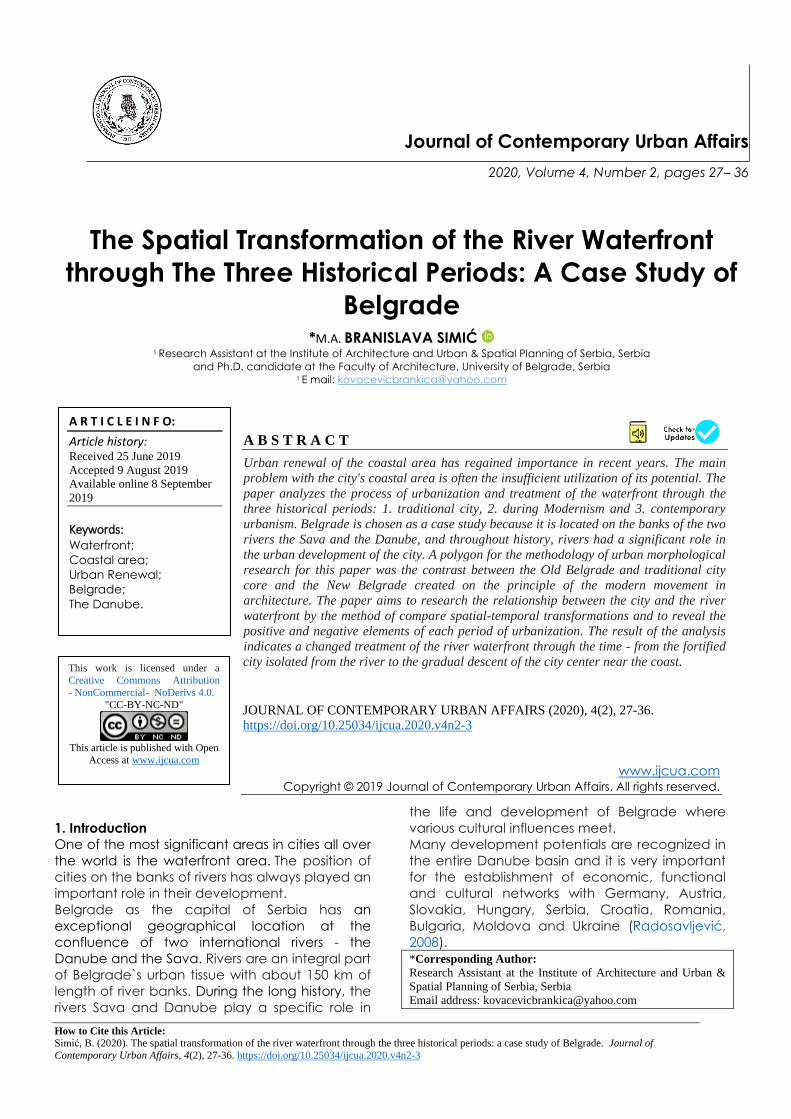
Figure 1.Belgrade: the city at the confluence of the rivers
Danube and Sava
(According to Master Plan of Belgrade of 1950)
2. The river waterfront in the traditional historic
city
The first observed period was the time of the
country's reconstruction after the Second World
War. The characteristics of this period are:
- accelerated development,
- modest economic potentials,
- a country devastated by the war (the
housing stock, infrastructure, public and
industrial facilities were destroyed),
- development of residential settlements
and administrative buildings on a
swampy land on the left bank of the
Sava River.
The rivers played a decisive role in establishing
international traffic connections and the
inclusive economic development of Belgrade in
the 19th century and its transformation from an
oriental settlement into a modern European city.
After 1830 Belgrade was rapidly developing as a
commercial and trading center (Bajić and
Basarić, 2014). The coastal area around
Kalemegdan fortress played an extremely
important role in the period of liberation from the
Turkish influence and the creation of the new
Serbian Belgrade. The position at the confluence
of the river enabled the city's commercial
prosperity since the transport of goods was
carried out to the greatest extent by river flows,
and especially benefited from the intensive
development of the industry which was the main
carrier of modernization and urban
development, especially in the period until the
First World War (Bajić and Basarić, 2014).
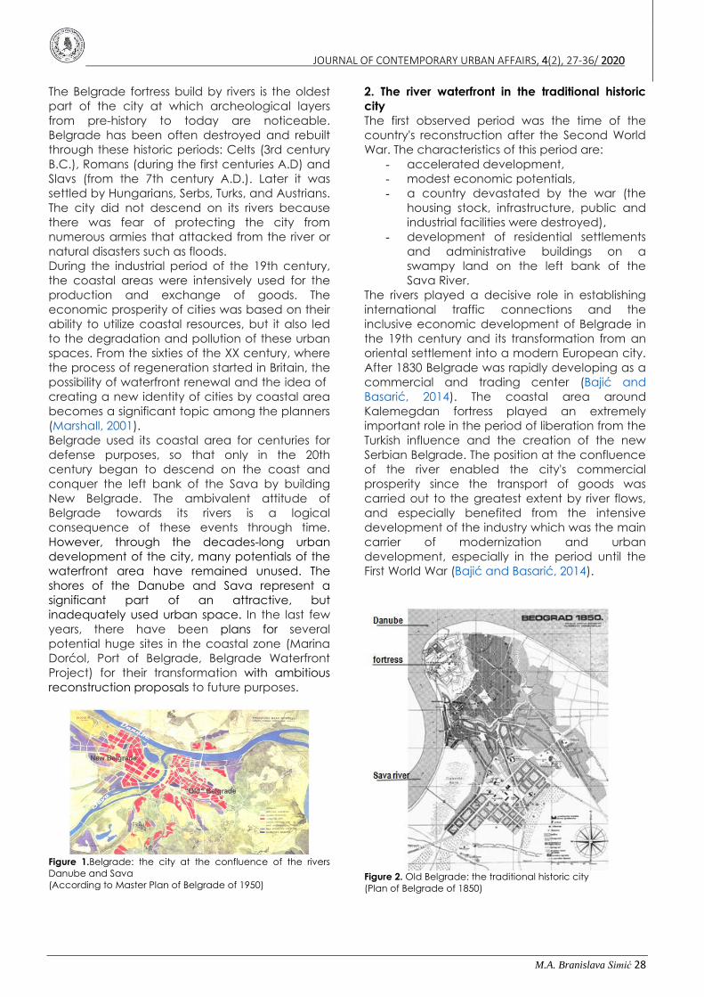
Figure 2. Old Belgrade: the traditional historic city
(Plan of Belgrade of 1850)

JOURNAL OF CONTEMPORARY URBAN AFFAIRS, 4(2), 27-36/ 2020
M.A. Branislava Simić 29
Figure 3. Old Belgrade by the river Sava(Photo of Belgrade
1920, according to: `Politika` newspaper 13.2.2013.)
Construction of the railway along the right bank
of the Sava and Danube was a key factor in
industrialization, but also represents the
separation of river banks from the city core,
which to this day has remained one of the
biggest urban challenges and unresolved
problems (Vuksanović-Macura, 2015). At the
time of its formation, the industrial zone in the
coastal area was located on the periphery of
the settlement, but by its development and
expansion, a significant part of this zone, as well
as the Sava and the Danube riverbank, was at
central city locations. Soon after the construction
of a railway, the rapid development of this part
of the city began. The railway station, the river
port, and tram traffic have influenced the
development of a long-standing market place in
the coastal area, where the entire Belgrade
trade. As a consequence, this part of the city
became very attractive. Before the war in 1914,
important public buildings were built in this area
(Belgrade Cooperative, Hotel Bristol) became
symbols of the accelerated development of the
coastal area and its commercial, traffic and
cultural significance (Bajić and Basarić, 2014).
Figure 4. The railway next to river separating the Old Belgrade
from its waterfront
(Plan of Belgrade of 1929, author marked the railway
https://www.discusmedia.com/maps/serbian_town_plans/45
61/).
At the end of the nineteenth century, the
construction of the first industrial enterprises
started with the urbanization and the right bank
of the Danube. Before, this was an empty terrain
along the river. Since the beginning of the 20th
century, the industry has become one of the
most important holders of economic and urban
development in Belgrade. The new factories in
this industrial zone had formed along the river
after the opening of the Beton Hall, Danube
harbor and main Port of Belgrade (Mihajlov,
2011).
The 1923 Belgrade Master Plan's preparation and
implementation process, a significant moment in
Belgrade's political and urban history when, after
the First World War, the city lost its centuries-long
border position, becoming the capital of a newly
established extended country, the Kingdom SHS,
later the Kingdom of Yugoslavia. The goal of
government and city authorities was to create a
representative national capital and overcome
the city's existential and functional problems. The
1923 Master Plan introduced very innovative and
modern approaches to solving the city's
problems and improving residential areas, traffic,
and greenery. Although urban planning of
Belgrade in this and the following period, had
initiatives to move the rail traffic from the Sava
river coast, none of them was realized (Vukotić
Lazar and Roter-Blagojević, 2017).
It can be concluded for this period that the river
coast became the main market place, the
center of the gathering, that transport (railway)
was a priority in the city`s strategy of
development, and that important public
buildings with commercial or touristic purpose
were built in this area.
3. The river waterfront during Modernism
The Second observed period is marked by:
- strengthening of the economic and
political power of the State,
- technology improvement,
- massive industrial development,
- improvement of the standard of living
and freedom of movement across the
world,
- and international influences in
architecture.
In the period between the two world wars, after
the Sava ceased to be a border river, it was
considerate the possibility of the development of
Belgrade on its left bank of the Sava river. In the
years after the Second World War, on the left
bank of the Sava River, the construction of New
Belgrade was started as a new urban center. By
the way of its development, New Belgrade
represents a separate part of Belgrade, a "city in
the city". Conceived and built in an empty

JOURNAL OF CONTEMPORARY URBAN AFFAIRS, 4(2), 27-36/ 2020
M.A. Branislava Simić 30
territory, according to Blagojević (2007), as a
"city-symbol of the new state and ideology", New
Belgrade was also a city-polygon, where
principles of modernism and the ideas of the
functional city inspired by of Le Corbusier were
achieved. New Belgrade represents a relatively
pure and rare example of consistent
construction in the spirit of functionalism and
Modernism reflecting a clear approach
formulated in the Athens Charter (Blagojević,
2007).
Figure 5. A conceptual plan of Nikola Dobrović for New
Belgrade on the left bank of the Sava river 1948
(http://contemporarycity.org/2014/04/belgrade/)
The architect Nikola Dobrović, who was
appointed as the director of the established
Urban Planning Institute of Serbia, took the task
of solving the problems of urban development of
Belgrade, where he considered that the key to
solving all urban problems of the city lied in
traffic. Blagojević (2007) pointed out that
Dobrović treated greenery as a modernist idea
of the Garden City, so it was realized in New
Belgrade as a green zone of park-garden space
near the river similar to modern landscape
urbanism as Monclus (2018) suggests.
Figure 6. Museum of Modern Art in New Belgrade`s greenery
(http://www.slikavest.rs/nove-linije-povodom-otvaranja-
muzeja-savremene-umetnosti/)
Figure 7. The river coast arrangement next to Hotel
"Jugoslavija"(photo was given by the author BranislavJovin)
Although the fact that in the period of
industrialization, the areas beside the river
became places of impure, working zones,
economic and industrial facilities all over the
world, in Serbia, exceptionally during the time of
socialism, some important objects were located
in exclusive locations in the coastal area. This
thesis is confirmed by examples: the Palace of
Federation- SIV 1961, the Central Committee
building– CK 1965 (now Ušće), the hotel
Yugoslavia 1969 and the Museum of
Contemporary Arts 1965 and only built in the old
town waterfront "25 May" Sports and Recreation
Center 1971. Also, many objects were solved
through an architectural competition and were
planned at locations in the coastal area, such as
the Museum of the Revolution, the Military
Museum and the Belgrade Opera House. These
decisions had the urban symmetry and
architectural monumental impression more
typical for the Heroic period than for the
International style and Modern architecture, so it
can be characterized as the specificity of Serbia
and as a precursor to the time when the focus is
again turning toward the rivers
(PetrovićBalubdzić, 2017).
A new stage in the development of New
Belgrade marked the 1950 year where the idea
of New Belgrade as a governing city was
abandoned (Blagojević, 2007). Instead, the
program priority in the coming period becomes
housing for the working class, so a large number
of open residential blocks were built with
freestanding buildings in a lot of greenery. On
the large public green surfaces of the coastal
belt of New Belgrade, continuous paths have
been formed for recreation, primarily walking
and cycling.
The mass construction at a new part of the city
noticeably neglected the reconstruction of the
old city core, resulting in its devastation. At the
same time, the Sava river coast served for the
consent of ships and the unloading of goods,
and heavy road traffic was directed through the

JOURNAL OF CONTEMPORARY URBAN AFFAIRS, 4(2), 27-36/ 2020
M.A. Branislava Simić 31
street around the Kalemegdan fortress. The
revitalization of river banks, the relocation of the
railway station and the use of tourism potentials
have not been achieved during this period.
It can be concluded for this period that the river
coast becomes park-garden space for
recreation, but where important public buildings
with cultural and administrative purposes were
built.
4. The river waterfront in the contemporary
urbanism
The third observed period has these
characteristics:
- Considerable development mainly
through interpolations both in Belgrade
urban tissue and in New Belgrade,
- Due to the global economic crisis over
the past years, this development
stopped. The most important projects for
which international competitions have
been announced and quality results
obtained have also stopped,
- Great interventions in urbanism – huge
scale projects near rivers.
Coastal spaces play an important role in
processes marked as decomposition of the
urban matrix. The regeneration and activation of
the area of the Sava and Danube coasts is an
important aspect of recent initiatives of
Belgrade's urban development, which are being
carried out through various planned proposals
and studies, architectural and urban
competitions, as well as the ambitious ideas of
private investors. Today the coastal area is
treating as a space of special interest for the
development of the city, where various activities
and facilities are envisaged. The specific
strategic goal is the orientation of Belgrade
towards the rivers.
Projects of the transformation of the Belgrade
coast into a potentially high-level urban area
were made in the period after 2000 for several
important locations. In 2001, an architectural
and urban design contest was announced for
the program solution of a complex of the marina
"Dorćol". The competition solutions enabled the
main purpose of the marina to be maintained
with the necessary accompanying facilities, as
well as the revitalization and conversion of
valuable objects of industrial heritage in the
area. It should transform this devastated area on
the Danube coast into an exclusive mixed-use
zone with residential, commercial, sports and
cultural facilities within the marine complex of
the total area of 76,000m2. The Master Plan for
the Belgrade Port, created in 2009 by Daniel
Libeskind Studio in cooperation with Gehl
Architects, envisions a complete urban
reconstruction of the existing port complex. The
project covers an area of 96 ha. A network of
public spaces, the formation of a new city park,
the introduction of mixed content and greater
density of construction are strategic elements of
the plan. The site is generally upgraded to a new
level because of flooding, with low-level routes
and platforms providing access for low water
levels. In many places, the stairs will lead to the
river, allowing direct contact with the water
surface, which is generally the lack of all existing
Belgrade river banks.
Figure 7. Revitalization of Port Belgrade /Daniel Libeskind&
Jan Gehl (http://www.lukabeograd.com/en/city-on-
wather/master-plan/strategy.html)
There was an international competition in 2011
for the architectural and urban solution of "Beton
Hala" where Sou Fujimoto and their vision of
building as "floating cloud" become an answer
to the accurate problems of the coast. Another
urban regeneration project in the coastal area
was the master plan "Beko" in 2012 of Zaha
Hadid architects, planned to build right in the
oldest part of the town, near Kalemegdan
fortress, a complex of residential, business,
commercial and hotel spaces.
Figure 8. Revitalization of Port "BetonHala"/ Sou Fujimoto
(https://www.archdaily.com/286381/beton-hala-waterfront-
center-sou-fujimoto-architects)
Figure 9. Urban regeneration of "Beko"/ Zaha Hadid
Architects (http://www.zaha-hadid.com/architecture/beko-
masterplan/)
JOURNAL OF CONTEMPORARY URBAN AFFAIRS, 4(2), 27-36/ 2020
M.A. Branislava Simić 32
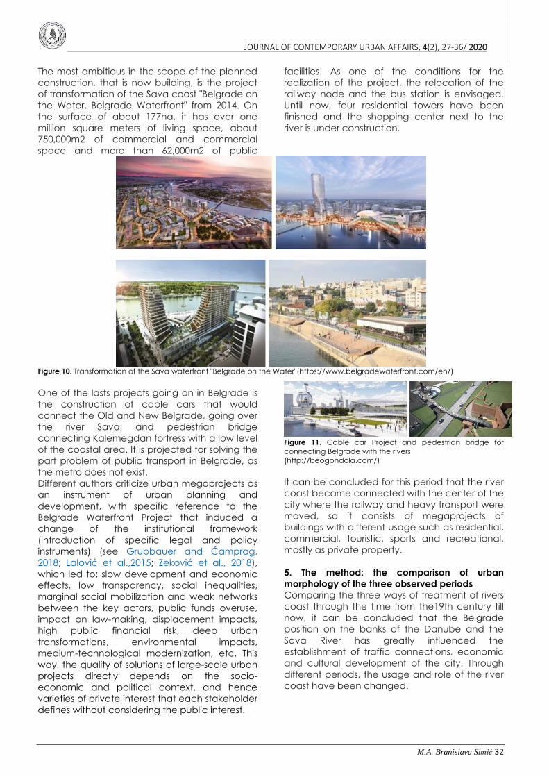
The most ambitious in the scope of the planned
construction, that is now building, is the project
of transformation of the Sava coast "Belgrade on
the Water, Belgrade Waterfront" from 2014. On
the surface of about 177ha, it has over one
million square meters of living space, about
750,000m2 of commercial and commercial
space and more than 62,000m2 of public
facilities. As one of the conditions for the
realization of the project, the relocation of the
railway node and the bus station is envisaged.
Until now, four residential towers have been
finished and the shopping center next to the
river is under construction.
Figure 10. Transformation of the Sava waterfront "Belgrade on the Water"(https://www.belgradewaterfront.com/en/)
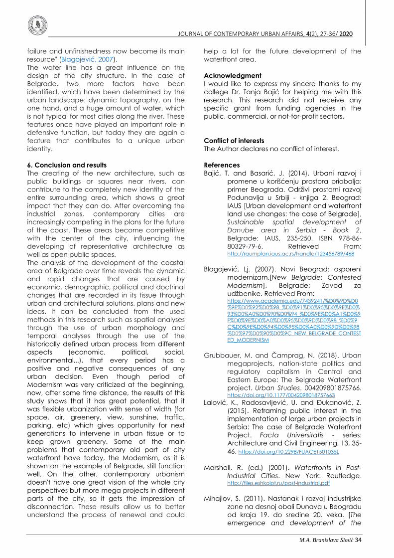
One of the lasts projects going on in Belgrade is
the construction of cable cars that would
connect the Old and New Belgrade, going over
the river Sava, and pedestrian bridge
connecting Kalemegdan fortress with a low level
of the coastal area. It is projected for solving the
part problem of public transport in Belgrade, as
the metro does not exist.
Different authors criticize urban megaprojects as
an instrument of urban planning and
development, with specific reference to the
Belgrade Waterfront Project that induced a
change of the institutional framework
(introduction of specific legal and policy
instruments) (see Grubbauer and Čamprag,
2018; Lalović et al.,2015; Zeković et al., 2018),
which led to: slow development and economic
effects, low transparency, social inequalities,
marginal social mobilization and weak networks
between the key actors, public funds overuse,
impact on law-making, displacement impacts,
high public financial risk, deep urban
transformations, environmental impacts,
medium-technological modernization, etc. This
way, the quality of solutions of large-scale urban
projects directly depends on the socio-
economic and political context, and hence
varieties of private interest that each stakeholder
defines without considering the public interest.
Figure 11. Cable car Project and pedestrian bridge for
connecting Belgrade with the rivers
(http://beogondola.com/)
It can be concluded for this period that the river
coast became connected with the center of the
city where the railway and heavy transport were
moved, so it consists of megaprojects of
buildings with different usage such as residential,
commercial, touristic, sports and recreational,
mostly as private property.
5. The method: the comparison of urban
morphology of the three observed periods
Comparing the three ways of treatment of rivers
coast through the time from the19th century till
now, it can be concluded that the Belgrade
position on the banks of the Danube and the
Sava River has greatly influenced the
establishment of traffic connections, economic
and cultural development of the city. Through
different periods, the usage and role of the river
coast have been changed.

JOURNAL OF CONTEMPORARY URBAN AFFAIRS, 4(2), 27-36/ 2020
M.A. Branislava Simić 33
Table 1. Main characteristics for the three observed periods with different treatment of river waterfront
Positive
Negative
Pe
rio
d
Of
The
Tra
ditio
na
l H
isto
ric
City
• from the defensive role of the river
coast to the main market place, the
center of the gathering
• industrialization brought the
factories, warehouses, and landfills,
shipyards, industry and transport facilities
occupied a wider part of the coastal area
• transport as a priority in the city`s
strategy of development
• railway going through the city
historic core, next to the river, separated it
from the city
• important public buildings with
commercial or touristic purpose were built
in this area
• without adequate greenery
Pe
rio
d O
f M
od
ern
ism
• green zone of park-garden space near
the river
• difficult maintenance of large
public spaces of greenery making the
devastated surrounding
• A place for recreation, primarily walking
and cycling
• lack of other activities for the
attraction of people to stay longer near
the river
• important public buildings with
cultural and administrative purpose were
built in this area
• the appearance of illegal rafts
and various floating objects
Pe
rio
d
Of
th
e
Co
nte
mp
ora
ry
Urb
an
ism
• residential buildings next to the
river with a great view
• the high density of population
• the used advantage for the most
attractive part of the city, railway and
heavy transport is moved from the city
center
• the lack of large enough real
public spaces along the river (shopping
mall is just for public use, but not
ownership)
• a lot of different activities such as
commercial, touristic, sports and
recreational
• huge occupancy of the plot,
almost without public greenery
• people are close to the river as
there is an accessible narrow path for
walkers but also and bicycles next to the
coastline with stairs and terraces
• lack of cultural spaces and
buildings
• it is connected with the rest of the
city
• residential segregation as it could
afford the only rich level of society
The inadequate use of land resulted in the
inability to connect the city with its rivers and
harmed the quality of the environment. The
unsolvable problem of the railway and the transit
traffic for many years has made the coastal part
of Belgrade a deserted transit zone in the city
center itself. The connection of the inhabitants of
the city to the river, which reached the peak of
the development of the trading zone and the
construction of representative elite facilities in
the first observed period, was interrupted by the
construction of a railway at the beginning of the
20th century. After that, the coast lost its
significance and became a transit zone. This
leads to a gradual degradation of its urban and
ecological qualities. Cutting the flow of people
and greenery between the two axes - the Sava
and railway - be a key problem of these two
zones.
One of the problems with the treatment of river
waterfront during modernism, except for the lack
of the different content and objects, is that was
built a rigid hydro-technical concrete fort system
along the whole coastline. It can be part of the
reason why Belgrade never completely
descended on its rivers. Such systems have been
overcome, both functionally and esthetically
and since it shows over years that they are
insufficient and that their upgrading is necessary.
The system with water canal incorporated into
the urban tissue of the city which can be useful
control during floods, that suggested Libeskind
and Gehl in their proposal for Port Belgrade, is
more contemporary. However, the future
development of the New Belgrade riverside and
re-functionalization of the broadly planned
greenery, which was planned during modernism,
could be now considered from another
perspective according to Blagojević, that "its
JOURNAL OF CONTEMPORARY URBAN AFFAIRS, 4(2), 27-36/ 2020
M.A. Branislava Simić 34
failure and unfinishedness now become its main
resource" (Blagojević, 2007).
The water line has a great influence on the
design of the city structure. In the case of
Belgrade, two more factors have been
identified, which have been determined by the
urban landscape: dynamic topography, on the
one hand, and a huge amount of water, which
is not typical for most cities along the river. These
features once have played an important role in
defensive function, but today they are again a
feature that contributes to a unique urban
identity.
6. Conclusion and results
The creating of the new architecture, such as
public buildings or squares near rivers, can
contribute to the completely new identity of the
entire surrounding area, which shows a great
impact that they can do. After overcoming the
industrial zones, contemporary cities are
increasingly competing in the plans for the future
of the coast. These areas become competitive
with the center of the city, influencing the
developing of representative architecture as
well as open public spaces.
The analysis of the development of the coastal
area of Belgrade over time reveals the dynamic
and rapid changes that are caused by
economic, demographic, political and doctrinal
changes that are recorded in its tissue through
urban and architectural solutions, plans and new
ideas. It can be concluded from the used
methods in this research such as spatial analyses
through the use of urban morphology and
temporal analyses through the use of the
historically defined urban process from different
aspects (economic, political, social,
environmental...), that every period has a
positive and negative consequences of any
urban decision. Even though period of
Modernism was very criticized at the beginning,
now, after some time distance, the results of this
study shows that it has great potential, that it
was flexible urbanization with sense of width (for
space, air, greenery, view, sunshine, traffic,
parking, etc) which gives opportunity for next
generations to intervene in urban tissue or to
keep grown greenery. Some of the main
problems that contemporary old part of city
waterfront have today, the Modernism, as it is
shown on the example of Belgrade, still function
well. On the other, contemporary urbanism
doesn't have one great vision of the whole city
perspectives but more mega projects in different
parts of the city, so it gets the impression of
disconnection. These results allow us to better
understand the process of renewal and could
help a lot for the future development of the
waterfront area.
Acknowledgment
I would like to express my sincere thanks to my
college Dr. Tanja Bajić for helping me with this
research. This research did not receive any
specific grant from funding agencies in the
public, commercial, or not-for-profit sectors.
Conflict of interests
The Author declares no conflict of interest.
References
Bajić, T. and Basarić, J. (2014). Urbani razvoj i
promene u korišćenju prostora priobalja:
primer Beograda. Održivi prostorni razvoj
Podunavlja u Srbiji - knjiga 2. Beograd:
IAUS [Urban development and waterfront
land use changes: the case of Belgrade],
Sustainable spatial development of
Danube area in Serbia - Book 2,
Belgrade: IAUS, 235-250. ISBN 978-86-
80329-79-6. Retrieved From: http://raumplan.iaus.ac.rs/handle/123456789/468
Blagojević, Lj. (2007). Novi Beograd: osporeni
modernizam.[New Belgrade: Contested
Modernism], Belgrade: Zavod za
udžbenike. Retrieved From: https://www.academia.edu/7439241/%D0%9D%D0
%9E%D0%92%D0%98_%D0%91%D0%95%D0%9E%D0%
93%D0%A0%D0%90%D0%94_%D0%9E%D0%A1%D0%9
F%D0%9E%D0%A0%D0%95%D0%9D%D0%98_%D0%9
C%D0%9E%D0%94%D0%95%D0%A0%D0%9D%D0%98
%D0%97%D0%90%D0%9C_NEW_BELGRADE_CONTEST
ED_MODERNISM
Grubbauer, M. and Čamprag, N. (2018). Urban
megaprojects, nation-state politics and
regulatory capitalism in Central and
Eastern Europe: The Belgrade Waterfront
project. Urban Studies. 004209801875766. https://doi.org/10.1177/0042098018757663
Lalović, K., Radosavljević, U. and Đukanović, Z.
(2015). Reframing public interest in the
implementation of large urban projects in
Serbia: The case of Belgrade Waterfront
Project. Facta Universitatis - series:
Architecture and Civil Engineering, 13, 35-
46. https://doi.org/10.2298/FUACE1501035L
Marshall, R. (ed.) (2001). Waterfronts in Post-
Industrial Cities. New York: Routledge. http://files.eshkolot.ru/post-industrial.pdf
Mihajlov, S. (2011). Nastanak i razvoj industrijske
zone na desnoj obali Dunava u Beogradu
od kraja 19. do sredine 20. veka. [The
emergence and development of the

JOURNAL OF CONTEMPORARY URBAN AFFAIRS, 4(2), 27-36/ 2020
M.A. Branislava Simić 35
industrial zone on the right bank of the
Danube in Belgrade from the end of 19th
till middle of 20th century]. Nasleđe, 12,
91-116.Retrieved From: http://scindeks.ceon.rs/article.aspx?query=ISSID%26
and%269923&page=4&sort=8&stype=0&backurl=%2
Fissue.aspx%3Fissue%3D9923
Monclus, J. (2018). Waterfronts and
Riverfronts. Recovery of Urban
Waterfronts. Urban Visions: From
Planning Culture to Landscape
Urbanism, pp.133-142. https://doi.org/10.1007/978-3-319-59047-
9_13.
Petrović Balubdžić, M. (2017). Creating the
Belgrade waterfront identity through a
prism of architecture and urban planning
competitions. Spatium, 1. 74-81. https://doi.org/10.2298/SPAT1737074P
Radosavljević, U. (2008). Conditions influencing
waterfront development and urban
actors capacity as a strategic response.
Spatium, No 17-18, pp. 78-83. https://doi.org/10.2298/SPAT0818078R
Vukotić Lazar, M. and Roter-Blagojević, M.
(2017). The 1923 Belgrade Master Plan –
historic town modernization. Planning
Perspectives, 33, 1-18. https://www.tandfonline.com/doi/abs/10.1080/0266
5433.2017.1408485
Vuksanović-Macura, Z. (2015). Bara Venecija
and Savamala: The railway and the city.
Nasledje, 2015, 9-26. https://doi.org/10.5937/nasledje1516009V
Zeković, S., Maricić, T. and Vujošević, M. (2018).
Megaprojects as an Instrument of Urban
Planning and Development: Example of
Belgrade Waterfront. Technologies
forDevelopment, 153-
164.https://doi.org/10.1007/978-3-319-91068-0_13
How to Citethis Article: Simić, B. (2020). The spatial transformation of the river waterfront
through the three historical periods: a case study of Belgrade. Journal of
Contemporary Urban Affairs, 4(2), 27-36.
https://doi.org/10.25034/ijcua.2020.v4n2-3

JOURNAL OF CONTEMPORARY URBAN AFFAIRS, 4(2), 27-36/ 2020
M.A. Branislava Simić 36
www.ijcua.com
This page is intentionally left blank.