the south florida region and its water management system linda lindstrom, p.g. director...
TRANSCRIPT

The South Florida Region and its
Water Management System
The South Florida Region and its
Water Management System
Linda Lindstrom, P.G. Director
Environmental Resource Assessment DepartmentSouth Florida Water Management District, USA
Linda Lindstrom, P.G. Director
Environmental Resource Assessment DepartmentSouth Florida Water Management District, USA


•Oldest and largest, covering 18,000 sq. miles and 16 counties from Orlando to Key West
•Manages water resources in southern half of state with a population of over 6 million
• 1800 employees and $1.4 billion annual budget
• Largest landowner in the state
The South Florida Water Management DistrictThe South Florida Water Management District

Kissimmee-Okeechobee-Everglades Ecosystem
Kissimmee-Okeechobee-Everglades Ecosystem
Florida Keys National Marine Sanctuary
Miami
Kissimmee River
Lake Okeechobee
Caloosahatchee River and Estuary
Big Cypress National Preserve
Everglades National Park
Water Conservation
Areas
St. Lucie River and Estuary
Biscayne Bay National Park
Orlando

Florida is basically flat and has a subtropical climate with “extremes” - fluctuating
between being very wet and very dry
Florida is basically flat and has a subtropical climate with “extremes” - fluctuating
between being very wet and very dry

At the turn of the last century, the South
Florida terrain was wild and wet
At the turn of the last century, the South
Florida terrain was wild and wet

Our history has been one of “dredge and drain the
swamp”
Our history has been one of “dredge and drain the
swamp”

Historical ProblemsHistorical Problems• Flood Control
– 1926/1928 Hurricanes: Lake Okeechobee Levee Failure (Herbert Hoover Dike)
– 1947 Hurricane: widespread flooding throughout south Florida
• Water Supply– 1931-1945 Droughts:
Lower East coast saltwater intrusion threat identified
• State of Florida requested federal assistance
Areas Floodedin 1926 &
1928

The Central and Southern Florida (C&SF)
Flood Control Project:
The Central and Southern Florida (C&SF)
Flood Control Project:Authorized by the U.S. Congress in 1948, began
the next year and continued for over 20 years


1949Central & South Florida Flood
Control District created to provide flood control
for the region
1949Central & South Florida Flood
Control District created to provide flood control
for the region
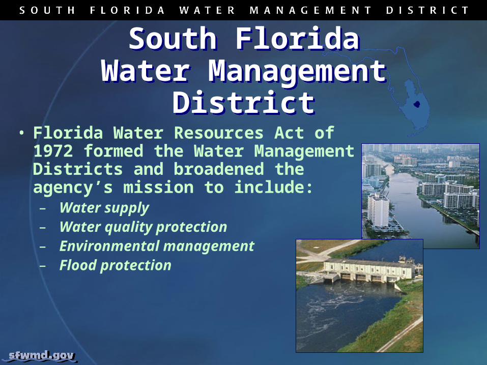
South FloridaWater Management
District
South FloridaWater Management
District• Florida Water Resources Act of 1972
formed the Water Management Districts and broadened the agency’s mission to include:– Water supply– Water quality protection– Environmental management– Flood protection

Water Management System Infrastructure
Water Management System Infrastructure• >1800 miles of canals and levees• 160 major drainage basins• >2,000 water control structures
and growing• 200 major structures
– 70 critical (remote automation)– 130 manual operations
• 36 pump stations (16 major)– 6 under remote automation/control

Water Management
System Infrastructure
Water Management
System InfrastructureOne of the world’s largest and most complex water resource management systems
One of the world’s largest and most complex water resource management systems

South Florida Water Resource Management Major Challenges
South Florida Water Resource Management Major Challenges• Applying integrative
regional management approaches to balance multiple water resources objectives, which are often conflicting
• Dealing with Florida’s climate “extremes”

South Florida Water Resource Management Major Challenges
South Florida Water Resource Management Major Challenges• Updating and retrofitting the aging
C&SF Project System and the Herbert Hoover Dike
• Ensuring water supply for ever-growing population
• Restoring and protecting natural systems stressed by population, urban/agricultural land use and invasive exotic plants and animals

The world’s largest ecosystem
restoration...
The world’s largest ecosystem
restoration...

…the Florida Everglades…the Florida Everglades

Historical EvergladesHistorical
Everglades
Everglades Today
Everglades Today

HistoricHistoricFlowFlow
HistoricHistoricFlowFlow
CurrentCurrentFlowFlow
CurrentCurrentFlowFlow
System Modifications
System Modifications

Comprehensive Everglades
Restoration Plan (CERP) –Getting the
Water Right
Comprehensive Everglades
Restoration Plan (CERP) –Getting the
Water Right• A framework and guide to
provide the right amount and quality of water and the right flow conditions to restore, protect, and preserve the natural systems along with an adequate water supply for urban and agricultural needs.
• Comprised of 68 major components, which are grouped into over 40 projects.– Physical Facilities (Reservoirs,
STAs, etc.)– Land Acquisition– Operations & Maintenance– 14 projects have been Accelerated

Welcome to South Florida!