the south downs way - s3-eu-west-1. · pdf filekev reynolds is a prolific author of guidebooks...
TRANSCRIPT

THE SOUTH DOWNS WAY
About the AuthorKev Reynolds is a prolific author of guidebooks whose first title for Cicerone Press (Walks and Climbs in the Pyrenees) was published in 1978 and has remained in print ever since. Although most of his books are devoted to mountain regions such as the Alps, Pyrenees and Himalaya, he considers the more gentle landscapes of the English countryside to be no second best, and says that every day spent among them is a gift to cherish. As a member of the Alpine Club, Austrian Alpine Club and an Honorary Life Member of the Outdoor Writers’ and Photographers’ Guild, his passion for mountains in particular and the countryside in general remains undiminished after a lifetime’s activity, and he regularly travels throughout Britain to share that passion through his lectures. Check him out at www.kevreynolds.co.uk.
Other Cicerone guides by the author100 Hut Walks in the AlpsA Walk in the CloudsAbode of the GodsAlpine Pass RouteAlpine Points of ViewCentral SwitzerlandChamonix to ZermattEcrins National ParkEverest: A Trekker’s GuideKangchenjunga: A Trekker’s GuideLangtang with Gosainkund &
Helambu: A Trekker’s GuideManaslu: A Trekker’s GuideThe Bernese Alps – SwitzerlandThe Cotswold WayThe North Downs WayThe PyreneesThe South Downs Way
Map BookletThe Swiss Alps
Tour of Mont BlancTour of the Jungfrau RegionTour of the Oisans: GR54Tour of the VanoiseTrekking in the AlpsTrekking in the HimalayaTrekking in the Silvretta and
Rätikon AlpsWalking in AustriaWalking in KentWalking in SussexWalking in the AlpsWalking in the Valais – SwitzerlandWalking in Ticino – SwitzerlandWalks and Climbs in the PyreneesWalks in the Engadine
– SwitzerlandWalks in the South Downs
National Park

THE SOUTH DOWNS WAYby Kev Reynolds
2 POLICE SQUARE, MILNTHORPE, CUMBRIA LA7 7PYwww.cicerone.co.uk
© Kev Reynolds 2017Fourth edition 2017ISBN: 978 1 85284 940 5Third edition 2015Second edition 2004First edition 2001
Printed in China on behalf of Latitude Press LtdA catalogue record for this book is available from the British Library.All photographs are by the author.
© Crown copyright 2017 OS PU100012932
This book is for Charlie Moon
Updates to this GuideWhile every effort is made by our authors to ensure the accuracy of guidebooks as they go to print, changes can occur during the lifetime of an edition. Any updates that we know of for this guide will be on the Cicerone website (www.cicerone.co.uk/940/updates), so please check before planning your trip. We also advise that you check information about such things as transport, accommodation and shops locally. Even rights of way can be altered over time. We are always grateful for information about any discrepancies between a guidebook and the facts on the ground, sent by email to [email protected] or by post to Cicerone, 2 Police Square, Milnthorpe LA7 7PY, United Kingdom.
Front cover: Typical South Downs Way signpost above Exton

CONTENTS
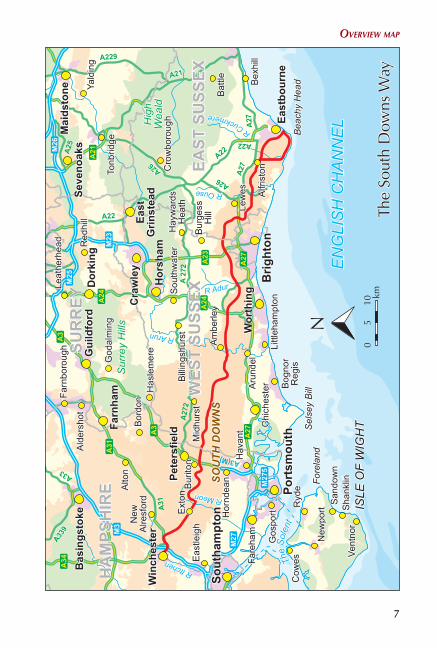
Overview map . . . . . . . . . . . . . . . . . . . . . . . . . . . . . . . . . . . . . . . . . . . . . . . . . 7Trek planner . . . . . . . . . . . . . . . . . . . . . . . . . . . . . . . . . . . . . . . . . . . . . . . . . . . 8Map keys . . . . . . . . . . . . . . . . . . . . . . . . . . . . . . . . . . . . . . . . . . . . . . . . . . . . . 9Route summary table . . . . . . . . . . . . . . . . . . . . . . . . . . . . . . . . . . . . . . . . . . . 10
INTRODUCTION . . . . . . . . . . . . . . . . . . . . . . . . . . . . . . . . . . . . . . . . . . . . . 11The Downs . . . . . . . . . . . . . . . . . . . . . . . . . . . . . . . . . . . . . . . . . . . . . . . . . . . 13The South Downs Way . . . . . . . . . . . . . . . . . . . . . . . . . . . . . . . . . . . . . . . . . . 16Accommodation . . . . . . . . . . . . . . . . . . . . . . . . . . . . . . . . . . . . . . . . . . . . . . . 20Practical advice . . . . . . . . . . . . . . . . . . . . . . . . . . . . . . . . . . . . . . . . . . . . . . . 21Walking companies and baggage transfers . . . . . . . . . . . . . . . . . . . . . . . . . . . 22Getting there – and back . . . . . . . . . . . . . . . . . . . . . . . . . . . . . . . . . . . . . . . . 23Using the guide . . . . . . . . . . . . . . . . . . . . . . . . . . . . . . . . . . . . . . . . . . . . . . . 23
TRAIL DESCRIPTION – WESTBOUND
Stage 1 Eastbourne to Alfriston (Footpath route via the Seven Sisters) . . . . . . . . . . . . . . . . . . . . . 27
Stage 1(a) Eastbourne to Alfriston (Bridleway route inland via Jevington) . . . . . . . . . . . . . . . . . . . . 36
Stage 2 Alfriston to Southease . . . . . . . . . . . . . . . . . . . . . . . . . . . . . . . . . 44Stage 3 Southease to Housedean (A27) . . . . . . . . . . . . . . . . . . . . . . . . . . 50Stage 4 Housedean (A27) to Pyecombe . . . . . . . . . . . . . . . . . . . . . . . . . 55Stage 5 Pyecombe to Botolphs (Adur Valley) . . . . . . . . . . . . . . . . . . . . . . 62Stage 6 Botolphs to Washington . . . . . . . . . . . . . . . . . . . . . . . . . . . . . . . 67Stage 7 Washington to Amberley . . . . . . . . . . . . . . . . . . . . . . . . . . . . . . 73Stage 8 Amberley to Cocking . . . . . . . . . . . . . . . . . . . . . . . . . . . . . . . . . 80Stage 9 Cocking to South Harting . . . . . . . . . . . . . . . . . . . . . . . . . . . . . . 89Stage 10 South Harting to Buriton (Queen Elizabeth Forest) . . . . . . . . . . . 96Stage 11 Buriton to Exton . . . . . . . . . . . . . . . . . . . . . . . . . . . . . . . . . . . . . 99Stage 12 Exton to Winchester . . . . . . . . . . . . . . . . . . . . . . . . . . . . . . . . . 109
TRAIL DESCRIPTION – EASTBOUNDStage 1 Winchester to Exton . . . . . . . . . . . . . . . . . . . . . . . . . . . . . . . . . 118Stage 2 Exton to Buriton . . . . . . . . . . . . . . . . . . . . . . . . . . . . . . . . . . . . 124Stage 3 Buriton to South Harting . . . . . . . . . . . . . . . . . . . . . . . . . . . . . . 132Stage 4 South Harting to Cocking . . . . . . . . . . . . . . . . . . . . . . . . . . . . . 136Stage 5 Cocking to Amberley . . . . . . . . . . . . . . . . . . . . . . . . . . . . . . . . 140

Stage 6 Amberley to Washington . . . . . . . . . . . . . . . . . . . . . . . . . . . . . 147Stage 7 Washington to Botolphs (Adur Valley) . . . . . . . . . . . . . . . . . . . . 151Stage 8 Botolphs to Pyecombe . . . . . . . . . . . . . . . . . . . . . . . . . . . . . . . 155Stage 9 Pyecombe to Housedean (A27) . . . . . . . . . . . . . . . . . . . . . . . . 159Stage 10 Housedean (A27) to Southease . . . . . . . . . . . . . . . . . . . . . . . . . 163Stage 11 Southease to Alfriston . . . . . . . . . . . . . . . . . . . . . . . . . . . . . . . . 167Stage 12 Alfriston to Eastbourne
(Footpath route via the Seven Sisters) . . . . . . . . . . . . . . . . . . . . 171Stage 12(a) Alfriston to Eastbourne
(Bridleway route inland via Jevington) . . . . . . . . . . . . . . . . . . . 179
Appendix A . . . . . . . . . . . . . . . . . . . . . . . . . . . . . . . . . . . . . . . . . . . . . . . . . 185Appendix B . . . . . . . . . . . . . . . . . . . . . . . . . . . . . . . . . . . . . . . . . . . . . . . . . 187Appendix C . . . . . . . . . . . . . . . . . . . . . . . . . . . . . . . . . . . . . . . . . . . . . . . . . 195
77
Overview map
A31
A339
A33
A26
A22
A21
A26
A22
A 27
2A
272
A229
A27
A25 A22
A27
A3
A3
A31
A27
A2
7
A23
A
24
A24
A
21
A34
A3(M)
M3
M27
M27
5
M23
M25
M26
The
Sole
nt
Hig
hW
eald
Sur
rey
Hill
s
SOU
TH D
OW
NS
Bea
chy
Hea
dS
else
y B
illFo
rela
nd
ISLE
OF
WIG
HT
Leat
herh
ead
Bill
ings
hurs
tH
ayw
ards
Hea
thM
idhu
rst
Red
hill
San
dow
nS
hank
lin
Bor
don
Bex
hill
Bat
tle
Cro
wbo
roug
h
God
alm
ing
Has
lem
ere
Vent
nor
Aru
ndel
Bur
gess
Hill
Cow
es
Alto
nN
ewA
lresf
ord
Yald
ing
Sou
thw
ater
Eas
tleig
h
New
portR
yde
Littl
eham
pton
Tonb
ridge
Farn
boro
ugh
Bog
nor
Reg
is
Gos
port
Ald
ersh
ot
Hav
ant
Hor
ndea
n
Bas
ings
toke
Win
ches
ter
Gui
ldfo
rdD
orki
ng
Farn
ham
Cra
wle
y
Mai
dsto
ne
East
bour
neB
right
on
Port
smou
th
Sout
ham
pton
Fare
ham
Wor
thin
g
Hor
sham
Seve
noak
s
East
Grin
stea
d
Pete
rsfie
ld
HA
MPS
HIR
E
WES
T SU
SSEX
EAST
SU
SSEX
SUR
REY
EN
GLI
SH
CH
AN
NE
L
Alfr
isto
n
Lew
es
Am
berle
y
Chi
ches
ter
Bur
iton
Ext
on
The
Sout
h D
owns
Way
R Adur
R Ouse
R Arun
R Meon
R Itchen
R Cuckmere
N 510
0km

8
The SouTh DownS wayThe SouTh DownS way
miles from Eastbourne
EASTBOURNEBeachy Head
LitlingtonAlfriston
(Jevington 3.5)
Housedean
Southease
Pyecombe
Truleigh HillBotolphs
Washington
Amberley
Clayton
Kingston
Houghton
Cocking
South Harting
Buriton
Wether Down
Exton
Beauworth
ChilcombWinchester
miles from Winchester
0
3
9.510.5
17.5
23.5
30.5
22
32
39.537.5
46.5
52.553.5
64.5
72
75.5
81.5
87.5
97.5
91.5
99.5
89
82
76
67.5
60
53
47
35
24
27.5
0
12
99.5
(97)
The South Downs Way Trek Planner
8
99
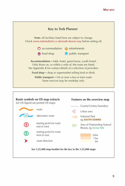
Note: all facilities listed here are subject to change.Check www.nationaltrail.co.uk/south-downs-way before setting o�.
Accommodation = b&b, hotel, guest house, youth hostel. Only those on, or within a mile of, the route are listed.
See Appendix B for contact details of a selection of providers.
Food shop = shop or supermarket selling food or drink.
Public transport = On or near a bus or train route.Some services may be weekday only.
refreshmentsaccommodation
public transportfood shop
Key to Trek Planner
Route symbols on OS map extracts Features on the overview map
starting point for route east to west
starting point for route west to east
route direction
(for OS legend see printed OS maps)
alternative route
route County/Unitary boundary
Urban area
National Park eg SOUTH DOWNS
See 1:25,000 map booklet for the key to the 1:25,000 maps
A
0m75m
200m
Area of Outstanding Natural Beauty, eg Surrey Hills
map keys

10
The SouTh DownS way
10
The SouTh DownS way
10
ROUTE SUMMARY TABLEThe South Downs Way – westboundStage Start/Finish Distance
(miles/km) Approx.
timePage
1 Eastbourne to Alfriston via Seven Sisters 10½ (17) 4–5hr 271a Eastbourne to Alfriston (bridleway) 8 (12.5) 3½–4hr 362 Alfriston to Southease 7 (11) 3–3½hr 443 Southease to Housedean (A27) 6 (9.5) 2½–3hr 504 Housedean (A27) to Pyecombe 8½ (13.5) 3½–4hr 555 Pyecombe to Botolphs 7½ (12) 3–3½hr 626 Botolphs to Washington 7 (11) 3–3½hr 677 Washington to Amberley 6 (9.5) 2½–3hr 738 Amberley to Cocking 12 (19) 6–7hr 809 Cocking to South Harting 7½ (12) 3–3½hr 8910 South Harting to Buriton (Queen
Elizabeth Forest)3½ (5.5) 1½–2hr 96
11 Buriton to Exton 12 (19) 6–7hr 9912 Exton to Winchester 12 (19) 6–7hr 109
Total: 99½ miles (158km) or 97 miles (153.5km)
The South Downs Way – eastboundStage Start/Finish Distance
(miles/km)Approx
timePage
1 Winchester to Exton 12 (19) 6–7hr 1182 Exton to Buriton 12 (19) 6–7hr 1243 Buriton to South Harting 3½ (5.5) 1½–2hr 1324 South Harting to Cocking 7½ (12) 3–3½hr 1365 Cocking to Amberley 12/19 6–7hr 1406 Amberley to Washington 6 (9.5) 2½–3hr 1477 Washington to Botolphs 7 (11) 3–3½hr 1518 Botolphs to Pyecombe 7½ (12) 3–3½hr 1559 Pyecomb to Housedean (A2) 8½ (13.5) 3½–4hr 15910 Housedean to Southease 6 (9.5) 2½–3hr 16311 Southease to Alfriston 7 (11) 3–3½hr 16712 Alfriston to Eastbourne via Seven Sisters 10½ (17) 4–5hr 17112a Alfriston to Eastbourne (bridleway) 8 (12.5) 3½–4hr 179
Total: 99½ miles (158km) or 97miles (153.5km)
11
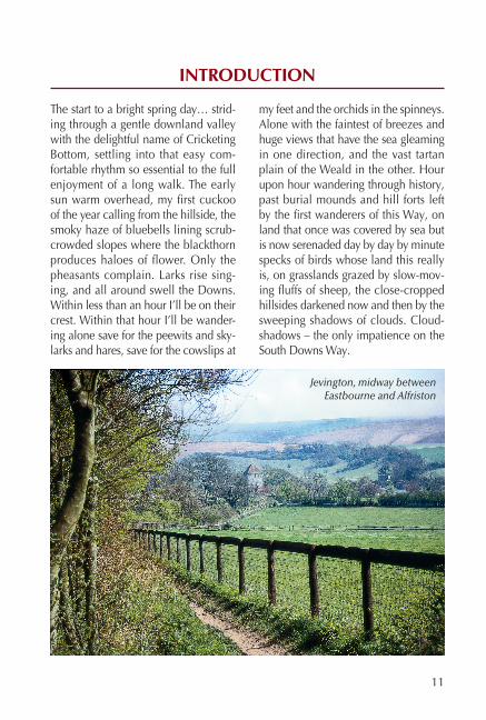
The start to a bright spring day… strid-ing through a gentle downland valley with the delightful name of Cricketing Bottom, settling into that easy com-fortable rhythm so essential to the full enjoyment of a long walk. The early sun warm overhead, my first cuckoo of the year calling from the hillside, the smoky haze of bluebells lining scrub-crowded slopes where the blackthorn produces haloes of flower. Only the pheasants complain. Larks rise sing-ing, and all around swell the Downs. Within less than an hour I’ll be on their crest. Within that hour I’ll be wander-ing alone save for the peewits and sky-larks and hares, save for the cowslips at
my feet and the orchids in the spinneys. Alone with the faintest of breezes and huge views that have the sea gleaming in one direction, and the vast tartan plain of the Weald in the other. Hour upon hour wandering through history, past burial mounds and hill forts left by the first wanderers of this Way, on land that once was covered by sea but is now serenaded day by day by minute specks of birds whose land this really is, on grasslands grazed by slow-mov-ing fluffs of sheep, the close-cropped hillsides darkened now and then by the sweeping shadows of clouds. Cloud-shadows – the only impatience on the South Downs Way.
INTRODUCTION
Jevington, midway between Eastbourne and Alfriston

12
The sOuTh DOwns way
More than two decades have passed since I first walked the South Downs Way, but I have been back several times, drawn by the visual delights to be won from the crest of this southern backbone of land with its overwhelming sense of space and peace, whose trails seem to wind on for ever – towards a dim, blue, never-to-be-reached, horizon. And each time I tread that smooth baize of turf and look north across the empty Weald, I find it hard to believe that this is the ‘overcrowded’ South of England.
This South is a surprisingly secret land, though its secrets are there to be unravelled if one only cares to look. It is misjudged and often maligned, and walking through and across it is the only way properly to discover its truths, for by wandering these ancient footpaths one absorbs its
essence through the soles of the feet. The cyclist and horse rider will also develop an affinity with the land, but without the direct physical contact known by the walker, a unique part of the experience will be missing.
Along the South Downs Way your field of vision expands with the miles to a greater knowledge of the land. The traveller begins to appreciate that it is not so populous as is generally thought, that its countryside is infi-nitely more varied than might previ-ously have been considered possible of the lowlands, and when you gain the scarp edge it is the panoramic expanse which throws into disarray any preconceived notion that moun-tains have a monopoly of landscape grandeur. Here the perspective fits. Scale is adjusted and beauty comes from order. In a world of constant
Celandines bank the trails with gold in April and May
The DOwns
13
change there is something reassuring in a vast acreage of countryside that somehow survives without too many scars – another eye-opener for the rambler in the South.
There are other surprises too, but these must be left for the wanderer, cyclist and horse rider to discover for him or herself, for along the South Downs Way any journey is bound to be full of rewards. Journeys of delight, journeys of discovery.
None but the walker can possi-bly understand the full extent of that statement, for it is only by the slow-ing of pace that one finds the abil-ity to become part of the landscape itself. This is not something that may be achieved from the seat of a motor vehicle, for motoring divorces you from the land, and at a speed which blurs and distorts. Along country
footpaths, however, there is so much to experience – from the succession of soil types beneath your feet to the nuance of every breeze that plays sculptor to the passing clouds. One breathes the fragrance of wayside plants, discovers the life of hedge-row and woodland shaw, and drifts through an unfolding series of pano-ramas. With senses finely tuned to the world about you, a footpath becomes a highway of constant discovery, of constant delight.
THE DOWNS
In the distant mists of time, during what is known as the Cretaceous period – that is, from about 100 mil-lion to 70 million years ago – the land we now know as the Weald lay beneath the waters of a warm,
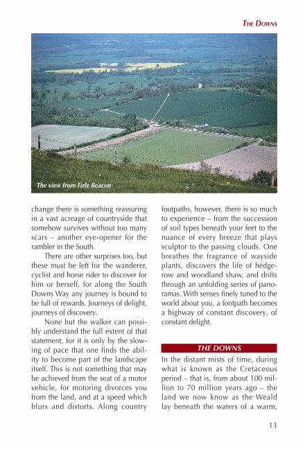
The view from Firle Beacon
14
The sOuTh DOwns way
shallow sea whose bed was covered by a sandwich of sedimentary depos-its. Miniscule shell-bearing organ-isms settled on this bed, the pure calcium carbonate of their shells powdering to a chalk dust that built with staggering patience to a depth of just one foot every 30,000 years or so. (Consider the time-scale required to produce the chalk cliffs of Beachy Head – over 500 feet/150m deep!) Yet this layer of soft crumbling chalk, composed of all these tiny shells, stretched from the Thames Valley to the Pas de Calais, and reached a depth of around 1000feet/300m, while into this white cheese-like rock there also settled the skeletons of sea sponges to form hard seams of flint.
Then, about 20 million years ago during the Tertiary period, came the continental collision which built the Alps. Italy was thrust into Europe and Spain was pressured from the south. Mountains were slowly buckled and,
as with a stone tossed into a pond, rip-ples spread in all directions. The chalk of southern England was raised into a huge dome rising from the sea and stretching for about 125 miles (200km), end to end. Weathering followed – a process that continues to this day. Rain, ice, frost, all combined to nibble away at this dome, aided and abetted by riv-ers and streams that found a weakness when the chalk cracked as it buckled. The outer edges of the dome were the last to crumble, the central core being carried away in watercourses that flowed through it. The centre of that lost dome is now the Weald, the outer edges the North and South Downs.
Rivers and streams continue to drain the Weald, breaching the Downs in valleys far broader than they now require, while dry knuckle coombs within the heart of this downland tell of streams that no longer exist.
Rambling along the smoothly rounded South Downs today we may
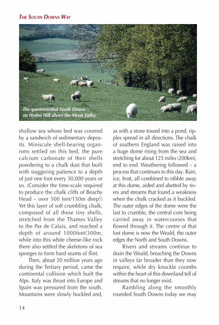
The quintessential South Downs – on Hyden Hill above the Meon Valley

The DOwns
15
wonder at this triumph of geologi-cal history. Gazing from the clifftop at Beachy Head we see the body of the land exposed, carved through as though with a gigantic scalpel. We gaze into the heart of unfathomable time, at the crushed, bleached rem-nants of creatures whose sacrifice is our gain.
East of the coastline, as the route of the South Downs Way leads away from the sea, that sacrifice is forgot-ten as we amble across grasslands rich in wild flowers. Yet beneath our boots the chalk lies deep, wait-ing only for the plough to expose its weaknesses to the wind. Where the path leads through arable land we see polished flints littering the fields, the chalk cushion around them turn-ing to dust under the influence of sun and wind, ready to be brushed away. The heights of the Downs shrink in
the summer breeze – one more act of sacrifice by creatures that long ago gave their shells to the southern landscape.
The common perception of the South Downs is one of rolling, flower-dazzled grasslands trimmed by sheep. This is partly due to the influence of our neolithic ancestors who crossed from continental Europe some 5000 years ago and settled here, raising animals, clearing trees and grow-ing crops. Until their arrival the hills would have been forested, but they, and the Iron Age settlers who arrived more than 2500 years later, cleared the forests for both agricultural purposes and for fuel, creating the open spaces that are such a feature of the eastern and central Downs today. The Romans too farmed the downland for corn, and grazed their animals on the rich meadows, but following the arrival of
Drifts of wood anemones carpet both woodland and shaw

27
STAGE 1
Eastbourne to Alfriston (Footpath route via the Seven Sisters)
Distance 10½ miles (17km)Time 4–5hrMaps Harvey South Downs Way
1:40,000; OS Landranger 199 Eastbourne & Hastings 1:50,000; OS Explorer 123 South Downs Way, Newhaven to Eastbourne 1:25,000
Accommodation Eastbourne, Beachy Head, Litlington and Alfriston
Refreshments Eastbourne, Beachy Head, Birling Gap, Exceat, Litlington, Alfriston
Of the two primary stages leading to Alfriston, this route across Beachy Head and the Seven Sisters is not a dedicated bridleway, but is the official walkers’ route – the bridleway alternative goes inland via Jevington, and is described as Stage 1(a) below. It is difficult to say which is the finer option for both have much to commend them. So good are the two options, in fact, that it is tempting to walk each one in due course. The clifftop region of Heritage Coast above Eastbourne is scenically dramatic, for the surf froths far below and, as you wander across Beachy Head, you have a lovely view ahead to the Seven Sisters, with Seaford Head beyond the estuary of Cuckmere Haven. The inland route, on the other hand, makes a splendid introduction to the Downs with wide open vistas almost every step of the way, while the little community of Jevington visited mid-journey is a typical flint-walled village with an attractive church in gentle surroundings.
The official route begins on the south-western edge of Eastbourne at Holywell. It then mounts steep, scrub-covered slopes to Beachy Head, continues across to Birling Gap and then tackles the rise and fall of the Seven Sisters. After leaving Haven Brow, the last of the ‘Sisters’, the route descends gently to the east bank of the Cuckmere, before cutting off and

28
The SouTh DownS way
Intro 1: To reach the start of the South Downs Way from Eastbourne railway station, walk along Grove Road passing the Town Hall, and follow Meads Road through the Meads area of town. At the junction of Beachy Head Road take Meads Street which leads past shops and eventually brings you to King Edward’s Parade. The walk begins where Dukes Drive makes a sharp right-hand bend. There’s a small café at the foot of a steep slope, and a South Downs Way notice-board depicting the route (grid ref: 600972).
Intro 2: To reach the start of the South Downs Way from the promenade, head south away from Eastbourne pier with the sea to your left, walking
Westbound: map continues on
page 31
rising once more, this time over sheep-grazed downland to the site of the former Exceat church, then down to the A259 near the Seven Sisters Visitor Centre. A steep hillside leads to Friston Forest where a fine view shows the lazy windings of the Cuckmere below. Westdean is briefly visited, then it’s back to forest again. But once the trees have been left behind high farmland takes the route down to Litlington and the banks of the Cuckmere, which makes a gentle companion for the final approach to Alfriston.
The sOuTh DOwns way

29
towards the stumpy martello tower4known as the Wish Tower. Beyond it there are neat lawns and flower beds. The promenade continues towards the cliffs and, as the path rises and brings you to a large landscaped mound with seats, bear right to King Edward’s Parade. Turn left to Holywell and, when Dukes Drive bends sharply to the right, you see the start of the South Downs Way directly ahead (grid ref: 600972).
The martello tower, known as the Wish Tower, is the sole survivor of four such towers originally built along Eastbourne’s seafront in 1806–7 to keep Napoleon at bay. During the Napoleonic Wars a whole series of these stocky circular towers were erected along the coastline of
Kent and Sussex, and named after the Torre del Martello in Napoleon’s homeland of Corsica.
Eastbourne is one of those South Coast resorts that has retained an air of gentility. It’s a town of flower beds and bowling greens, a town where Victorian imagery lingers on. The original settlement of East Bourne had a church before the Norman invasion. There were neighbouring hamlets called South Bourne and Sea Houses, the latter a collection of fishermen’s cottages, but the three were amalgamated in the mid 19th century, and in 1910 Eastbourne was created a borough. Development as a resort was due largely to the seventh Duke of Devonshire, and it has somehow managed to avoid the tackiness of so many of its coastal neighbours, and discreetly shuns vulgarity. Along the front, north of the pier, stands The Redoubt, a sturdy, circular building – mostly of brick – constructed in the early 1800s as part of the coastal defences against Napoleon. The Wish Tower (see below) also formed part of that defence system.
wesTbOunD – easTbOurne TO alfrisTOn via The seven sisTers
30
The SouTh DownS way
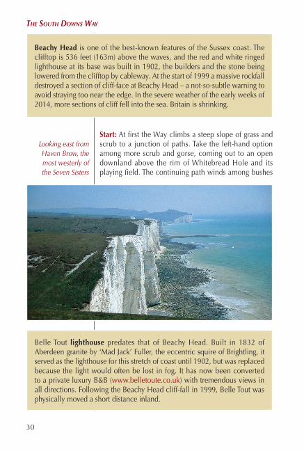
Start: At first the Way climbs a steep slope of grass and scrub to a junction of paths. Take the left-hand option among more scrub and gorse, coming out to an open downland above the rim of Whitebread Hole and its playing field. The continuing path winds among bushes
Beachy Head is one of the best-known features of the Sussex coast. The clifftop is 536 feet (163m) above the waves, and the red and white ringed lighthouse at its base was built in 1902, the builders and the stone being lowered from the clifftop by cableway. At the start of 1999 a massive rockfall destroyed a section of cliff-face at Beachy Head – a not-so-subtle warning to avoid straying too near the edge. In the severe weather of the early weeks of 2014, more sections of cliff fell into the sea. Britain is shrinking.
Belle Tout lighthouse predates that of Beachy Head. Built in 1832 of Aberdeen granite by ‘Mad Jack’ Fuller, the eccentric squire of Brightling, it served as the lighthouse for this stretch of coast until 1902, but was replaced because the light would often be lost in fog. It has now been converted to a private luxury B&B (www.belletoute.co.uk) with tremendous views in all directions. Following the Beachy Head cliff-fall in 1999, Belle Tout was physically moved a short distance inland.
Looking east from Haven Brow, the most westerly of the Seven Sisters

31
of blackthorn, gorse and elder and then, climbing steadily on an old coast-guard’s path and with splendid views over the sea, approaches Beachy Head. Refreshments can be found at the nearby Beachy Head Inn.
Continue along the clifftop, but do not stray too close to the edge as the cliffs are crumbling. The Way slopes down almost to road level below the former lighthouse of Belle Tout, then rises to pass round the inland side of the enclosing wall. Maintain direction across the cliffs, which were acquired by the National Trust in 1967 and form a designated Heritage Coast, and from which the Seven Sisters can be seen ahead. Before long you arrive at the few buildings and car park at Birling Gap (refreshments) (grid ref: 554960).
I was glad then to have chosen to walk westwards, for although the sky was bright and clear, a cold easterly wind was blowing, and I’d rather have that in my back than in my face all day long. On the clifftop walk tiny cowslips were coming into bloom, but few other flowers as yet. Later, and further inland, there would be plenty of colour around my boots, but up here I was well content with views over the sea, with the bleached roller-coaster of the Seven Sisters ahead with their thatch of downland grass, trim and neatly cropped, and recalled previ-ous clifftop wanderings at the end of a variety of long walks. The pleasure to be gained whilst wandering across the Seven Sisters never palls. There’s the cry of gulls, the sight, scent and sound of the sea, and broad vistas of the Downs stretching far away
Eastbound: map continues on page 28
wesTbOunD – easTbOurne TO alfrisTOn via The seven sisTers
32
The SouTh DownS way
inland. I had the wind in my hair and a hundred miles to cover at my own pace. It was good to be back.
A flint track heads past a small toilet block, and soon forks. The way ahead leads to East Dean, but we veer left and through a gate rejoin the clifftop path. The route now wanders over the Seven Sisters on a switch-back course with the sea glistening below to the left and the green baize of the Downs spreading far off to the right – the Crowlink Estate owned by the National Trust. On the first of the ‘Sisters’ an obelisk records the dedica-tion of land to the Trust in memory of two brothers killed in the First World War. Next is Baily’s Hill, followed by Flat Hill, Flagstaff Brow (another dedication stone), Rough Brow, Short Brow and Haven Brow. Between the ‘Sisters’ steep, dry valleys, or ‘bottoms’ can be testing for legs and knees, and the red faces of other walkers betray the effort of each ascent.
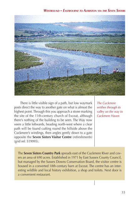
From Haven Brow a clear view shows Cuckmere Haven below, with Seaford Head on the far side. The Way slopes down and curves to the right and, on reach-ing the valley bed, goes through a gate and onto a chalk path, the Cuckmere River just to the left. Immediately after crossing a concrete farm road go through a kissing gate and walk up the slope ahead in a north-easterly direction.
Cuckmere Haven is the estuary of the Cuckmere River, a shingle bank guarded by Haven Brow and Seaford Head. In the 15th century it was more open than it is today, for in 1460 raiders from France sailed up the river to Exceat and attacked the village. (Exceat barely exists as a village today.) During the 18th century the Haven was a notorious landing place for smugglers, when contraband goods would be brought upstream to Exceat and Alfriston. As recently as 1923 smugglers were caught there with a haul of expensive brandy. A little inland from the Haven itself an artifi-cial lagoon attracts assorted waders, while the snaking Cuckmere between Exceat and the Haven is busy with swans, tufted ducks, dabchicks, cormo-rants and herons.
33
There is little visible sign of a path, but low waymark posts direct the way to another gate on what is almost the highest point. Through this you approach a stone marking the site of the 11th-century church of Exceat, although there’s nothing of the building to be seen. The Way now veers a little leftwards, heading north-west where a clear path will be found cutting round the hillside above the Cuckmere’s windings, then angles gently down to a gate opposite the Seven Sisters Visitor Centre (refreshments) (grid ref: 519995).
The Seven Sisters Country Park spreads east of the Cuckmere River and cov-ers an area of 690 acres. Established in 1971 by East Sussex County Council, but managed by the Sussex Downs Conservation Board, the visitor centre is housed in a converted 18th-century barn at Exceat. The centre has an inter-esting wildlife and local history exhibition, a shop and toilets. Next door is a convenient restaurant.
The Cuckmere writhes through its valley on the way to Cuckmere Haven
wesTbOunD – easTbOurne TO alfrisTOn via The seven sisTers

34
The SouTh DownS way
Cross the A259 with care and wander between a cycle hire building and a cottage, then through a kiss-ing gate and up a steep grass slope, at the top of which a stone stile leads through a wall to the edge of Friston Forest.3 There’s a very fine view from here, out to the Cuckmere’s valley easing towards Cuckmere Haven. Take the path ahead among trees, and soon descend more than 200 steps to the hamlet of Westdean which is reached beside an attractive duck pond. Continue ahead along a narrow road which becomes a track, and re-enter Friston Forest. Waymarks direct the South Downs Way to the left, but on coming to a junction of tracks, turn right, and when this bears sharp right near the forest edge, the Way goes ahead and descends more steps among trees behind Charleston Manor.3
The South Downs Way continues along a beech-lined track, then you veer right to cross a stile and follow a hedge. On the downland slopes to the west, a white horse can be seen cut in the chalk above the Cuckmere Valley, on the hill known as High and Over. Eventually come down to the flint-walled village of Litlington (refreshments, accommodation). Turn right in the village street as far as The Plough and Harrow pub. Just beyond this turn left along a narrow footpath leading to a bridge over the Cuckmere.
The continuing South Downs Way turns right and fol-lows the Cuckmere upstream, passing opposite the Clergy House and Alfriston parish church, to a bridge with white railings where the footpath route joins the bridleway (grid ref: 523031). Cross the bridge and walk ahead up an alleyway which brings you directly into Alfriston High
Friston Forest covers almost 2000 acres
of mainly broad-leaved woodlands.
It is owned by South East Water,
but managed by the Forestry Commission,
and there are several paths and
rides through it.
Charleston Manor, on the edge of Friston
Forest, is named in the Domesday Book
as being owned by William the
Conqueror’s cup-bearer, Cerlestone. In the grounds the restored tithe barn
is all of 177 feet (54m) long, with
an enormous tiled roof and a medieval
circular dovecote. The gardens are
open to the public on set days during
the summer.
Westdean is a historic little place. It is said that Alfred the Great built a palace here in ad 850, although no trace of it has been found. But there is a charming flint-built rectory dating from the 13th century, and a part-Nor-man church . Although very small, and with an air of seclusion, Westdean is worth exploring at leisure.

35
wesTbOunD – easTbOurne TO alfrisTOn via The seven sisTers
Street (refreshments, accommodation) where you turn right to The Star Inn.
Alfriston is something of a show-piece village, and is one of the busiest in Sussex with day-visitors. It boasts many interesting and picturesque buildings, a number of which have typical downland flint walls. The George Inn (built 1397) is said to have been a smuggler’s haunt, while The Star Inn, which dates from the 15th century, bears the figurehead of a Dutch ship that foundered in Cuckmere Haven. The 14th-century church of St Andrew, standing between the greensward of The Tye and the Cuckmere River, is often referred to as ‘the Cathedral of the Downs’. Nearby the thatched, half-timbered Clergy House is of similar age to the church, and was the first building bought (in 1896) by the National Trust – for just £10! Alfriston has several shops, restaurants, pubs and tearooms, and a choice of accommodation.
Litlington is tucked under the Downs on the east bank of the Cuckmere, its small Norman church wearing a white weatherboarded bell-tower and a shingled cap. Next door Church Farm is also very old, and has Caen stone in its walls, which leads some to suggest it may have been a priest’s house. The name of the village is derived from ‘Lytela’s farmstead’ and is pronounced Lillington.