the raffles bulletin of zoology, vol. 34
TRANSCRIPT
1. General Introduction
By J. A. Bullock) , ' v i ' • : '! ■ 1
and
Lord Medway
INTRODUCTION
Pulau tioman is the third largest island off the shores of Malaya; only P.Langkawi and P. Pinang (Penang) exceed it in area and these are more closelyrelated to the mainland than is Tioman. Several visits have been made to the islandby zoologists, although some of these have not been reported in the literature. Inall reported cases, the visits have been of short duration. Vertebratologists havebeen mainly concerned with the collection of museum specimens, principally ofthe higher classes, and have made little or no attempt to assess the populations ofspecies or their role in the ecology. The invertebrates have received little attention,with the exception of the Rhopalocera (Corbett and Pendlebury, 1956; Stubbs,1961) and the terrestrial Planaria (de Beauchamp, 1933). Medical workers have,however, accumulated much data, largely unpublished, on the anopheline vectorsof malaria and on the incidence of plasmodial infections in the human populace(Warren, this Bulletin, p. 150).
In March to April, 1962, a party from the Department of Zoology, University ofMalaya, spent six weeks on the island. The aims of this expedition were to undertakea study of the vertebrate fauna in relation to the ecology of the island, and to make acollection of insects and other terrestrial arthropods paying special attention to thefauna of jungle habitats and to the ectoparasites of vertebrates. Besides the authors,the party consisted of two technicians from the Department of Zoology, an insect-collector employed by the Bishop Museum, Honolulu, and an aborigine servant.This basic party was visited for short periods by several other groups: O. S.Elliot and D. R. Wells, both of the Department of Zoology, spent two weekson the island; a group from the Institute for Medical Research, Kuala Lumpur,consisting of F. L. Dunn, B. L. Lim, and McW. Warren, with three assistants,stayed for a week; and two plant collectors from the Botanic Gardens, Singapore,spent three weeks with us.
DESCRIPTION OF THE ISLAND
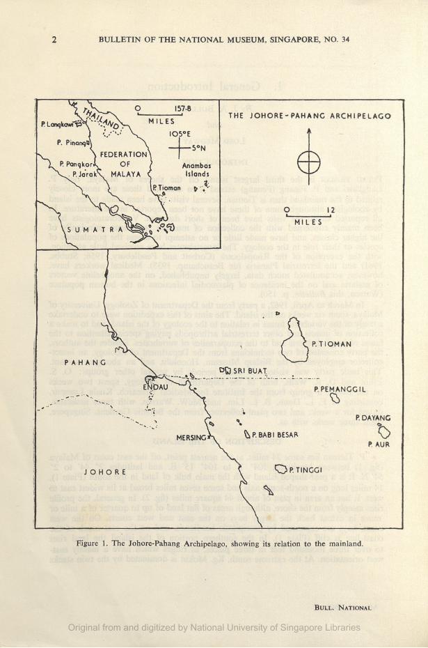
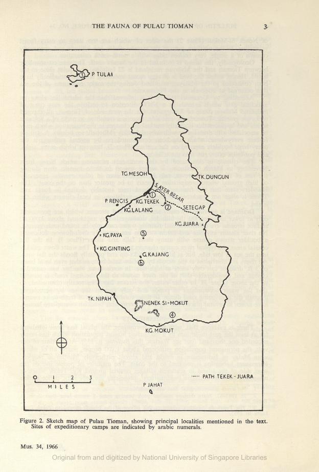
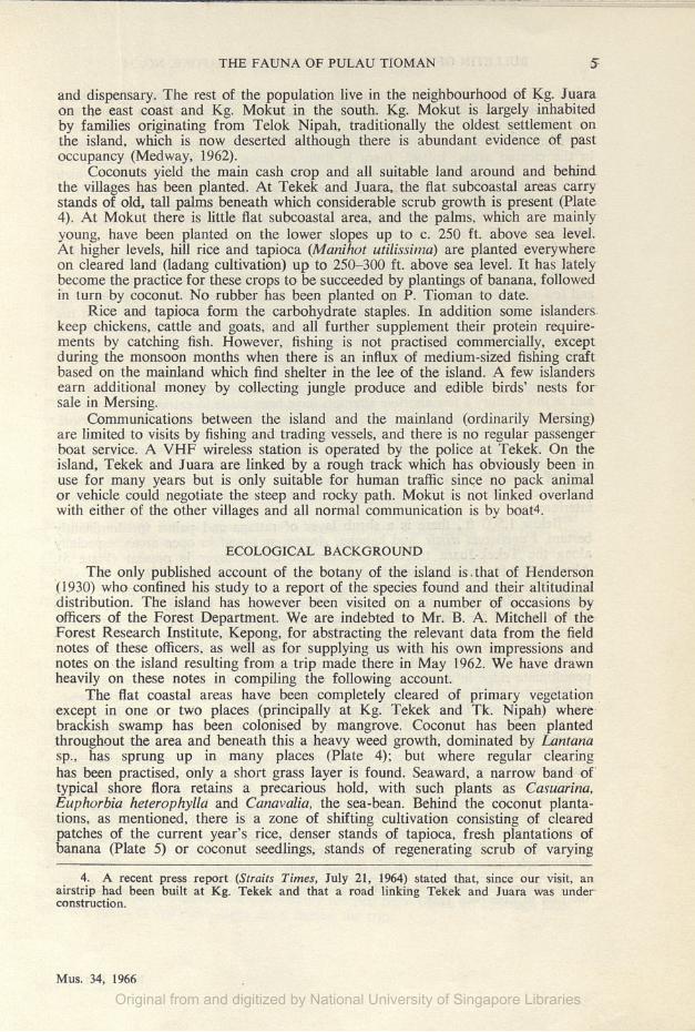
P. Tioman lies some 24 miles, at the nearest point, off the east coast of Malaya(fig. 1) between longitudes 104° 7' to 104° 15' E. and latitudes 2° 44' to 2°54' N. It is a pear-shaped island with the main bulk of land in the south (Plate 1),14 miles long on a north-south axis and some seven miles broad at its widest east towest. It has an area in plan of about 44 square miles (fig. 2). In general, the profilerises steeply from the shore, although areas of flat land of up to quarter of a mile ormore in extent back the larger bays on the east and west coasts. On the westcoast, bays are separated by precipitous headlands, and on the east much of thecoast-line is cliff (Plate 1). In the southern portion of the island the land risesto over three thousand feet in three places, as ridges which have a mainly east-west orientation. At the extreme south, Kg. Mokut is dominated by the twin stacks
Mus. 34, 1966Original from and digitized by National University of Singapore Libraries
2 BULLETIN OF THE NATIONAL MUSEUM, SINGAPORE, NO. 34
Bull. National
Original from and digitized by National University of Singapore Libraries
THE FAUNA OF PULAU TIOMAN 3
P RENGIS/"XG.TEKEK/kgtalang ..SETEGAP
KG.JUARA
kg.gintingg.KAJANG
'P TULAI
TG.MESOHV 'tk.duncun
TK.NIPAHi"""|NENEK SI-MOKUT
-A ©
KG. MOKUT
3 PATH TEKEK-JUARAP JAHAT
Figure 2. Sketch map of Pulau Tioman, showing principal localities mentioned in the text.Sites of expeditionary camps are indicated by arabic numerals.
Mus. 34, 1966
Original from and digitized by National University of Singapore Libraries
4 BULLETIN OF THE NATIONAL MUSEUM, SINGAPORE, NO. 34
of Nenek Si-Mokut (Plate 2) the sides of which are too steep to carry forestvegetation. In the northern portion the terrain attains less altitude and apparentlyconsists of a single, very broken ridge with a north-south orientation.
Geologically, the island is included in the Sunda shelf. The greatest soundingbetween Tioman and the Malayan mainland is 22 fathoms, at a point close to theisland. Hence, unless the land is of very recent upraising, it must periodically havebeen connected to the Malayan mainland during the major recessions of the seathat occurred at intervals in the Pleistocene.
According to Alexander (1962), it is inferred that the island lies along ananticlinal axis which extends in a NNW direction to include the east coast ofmainland Malaya (State of Trengganu). On the west side of Tioman, all exposedrocks are granitic. Towards the east side, there is a transition to rocks of a volcanicseries, and in places this is clearly marked by changes in the vegetation which maybe associated with drainage or with subsoil fertility (Mitchell, see below). A strikingfeature everywhere, which has been commented on by several authors, is themany large boulders exposed on the surface (Plate 2), between which caves, sinks,and pot-holes often run into the hillsides.
The climate is dominated by the north-east monsoon which blows fromNovember to March, producing a wetter season in these months than duringthe rest of the year. However, rain is frequent even in other months, especiallyon high ground where precipitation appears to be greater than on the coast1. Theislanders state that the fruiting of orchard trees (notably durian) in Juara andTekek is often not synchronised2, indicating variations in local climate within theisland.
Drainage is provided by many small rivers and streams, which are permanentonly at lower altitudes. On the hillsides, drainage is very rapid and above 2,000 ft.surface streams are ephemeral and running water can only be found underground.No river attains any size and forest streams are generally swift-flowing, followinga boulder strewn course with many short falls and slides (Plate 3). In the flatcoastal areas, the typical river course changes to a meander. The water flows quicklyinto the sea at low tide, but at high tide backs-up and partially floods the flat area.All rivers are obstructed at the mouth by shallow sand bars, so that even local boatsof 3 ft. draught can only enter at high tide. In some cases, the bar has caused achange and considerable shift of the river mouth so that the final reach is parallelto the shore (Plate 3). In other cases, the stream has been totally obstructed, sothat the water accumulates in ponds and only reaches the sea by percolatingthrough the intervening sand dunes. In these conditions areas of fresh-water swamphave arisen in several places, but regions of permanent brackish swamp are limited.
INHABITANTS
There is evidence that, with few interruptions, the island has been inhabitedfor at least the past millenium by a fluctuating human population which has rarelyexceeded one thousand (but see Warren, this Bulletin, p. 155). At the time of ourvisit, the permanent population numbered about 1,100 people, nearly all of whomwere Malay or Indonesian in origin and almost exclusively Muslim in religion.Permanent habitation is confined to the coast. The majority of people live on thewest side of the island in scattered villages centred around Kg. Tekek which isnowadays the administrative headquarters3, possessing the only jetty, police station
1. No exact meteorological data are available.2. In 1961-62, Juara durians reached peak bearing some 8 weeks later than those at
Tekek.3. The Penghulu (resident administrative officer of the island) moved to Tekek from
luara in 1953.
Bull. National
Original from and digitized by National University of Singapore Libraries
THE FAUNA OF PULAU TIOMAN 5
and dispensary. The rest of the population live in the neighbourhood of Kg- Juaraon the east coast and Kg. Mokut in the south. Kg. Mokut is largely inhabitedby families originating from Telok Nipah, traditionally the oldest settlement onthe island, which is now deserted although there is abundant evidence of pastoccupancy (Medway, 1962).
Coconuts yield the main cash crop and all suitable land around and behindthe villages has been planted. At Tekek and Juara, the flat subcoastal areas carrystands of old, tall palms beneath which considerable scrub growth is present (Plate4). At Mokut there is little fiat subcoastal area, and the palms, which are mainlyyoung, have been planted on the lower slopes up to c. 250 ft. above sea level.At higher levels, hill rice and tapioca (Manihot utilissima) are planted everywhereon cleared land (ladang cultivation) up to 250-300 ft. above sea level. It has latelybecome the practice for these crops to be succeeded by plantings of banana, followedin turn by coconut. No rubber has been planted on P. Tiornan to date.
Rice and tapioca form the carbohydrate staples. In addition some islanderskeep chickens, cattle and goats, and all further supplement their protein require¬ments by catching fish. However, fishing is not practised commercially, exceptduring the monsoon months when there is an influx of medium-sized fishing craftbased on the mainland which find shelter in the lee of the island. A few islandersearn additional money by collecting jungle produce and edible birds' nests forsale in Mersing.
Communications between the island and the mainland (ordinarily Mersing)are limited to visits by fishing and trading vessels, and there is no regular passengerboat service. A VHF wireless station is operated by the police at Tekek. On theisland, Tekek and Juara are linked by a rough track which has obviously been inuse for many years but is only suitable for human traffic since no pack animalor vehicle could negotiate the steep and rocky path. Mokut is not linked overlandwith either of the other villages and all normal communication is by boatA
ECOLOGICAL BACKGROUND
The only published account of the botany of the island is.that of Henderson(1930) who confined his study to a report of the species found and their altitudinaldistribution. The island has however been visited on a number of occasions byofficers of the Forest Department. We are indebted to Mr. B. A. Mitchell of theForest Research Institute, Kepong, for abstracting the relevant data from the fieldnotes of these officers, as well as for supplying us with his own impressions andnotes on the island resulting from a trip made there in May 1962. We have drawnheavily on these notes in compiling the following account.
The flat coastal areas have been completely cleared of primary vegetationexcept in one or two places (principally at Kg. Tekek and Tk. Nipah) wherebrackish swamp has been colonised by mangrove. Coconut has been plantedthroughout the area and beneath this a heavy weed growth, dominated by Lantanasp., has sprung up in many places (Plate 4); but where regular clearinghas been practised, only a short grass layer is found. Seaward, a narrow band oftypical shore flora retains a precarious hold, with such plants as Casuarina,Euphorbia heterophylla and Canavalia, the sea-bean. Behind the coconut planta¬tions, as mentioned, there is a zone of shifting cultivation consisting of clearedpatches of the current year's rice, denser stands of tapioca, fresh plantations ofbanana (Plate 5) or coconut seedlings, stands of regenerating scrub of varying
4. A recent press report (Straits Times, July 21, 1964) stated that, since our visit, anairstrip had been built at Kg. Tekek and that a road linking Tekek and Juara was underconstruction.
Mus. 34, 1966
Original from and digitized by National University of Singapore Libraries
6 BULLETIN OF THE NATIONAL MUSEUM, SINGAPORE, NO. 34
height and density (in which Lantana sp. dominates), irregular patches of secondaryforest (belukar) at all stages of growth from young and impenetrable to mature, tall,and relatively open.
Elsewhere, forest covers the whole island, extending down to the sea exceptin the cleared areas. Inland, there is little evidence of cultivation in the past.Along the Juara-Tekek track there is some land, since reverted to jungle, whichwas cleared during the time of the Japanese occupation. There is also a tradition,supported by the presence of old durian trees some two miles from the shore,that at Tk. Nipah, during the existence of the settlement, cultivation extended wellinland. In the Tk. Paya area too Mr. Mitchell found regeneration apparently datingfrom Japanese times. In all the recently cleared areas, the first stage of regenerationis marked by the presence of heavy Lantana growth.
The primary forest consists of tall, well spaced trees with a fairly open canopyand few emergents. The number of dipterocarp species is very limited. Undergrowthof all sorts is sparse on the west side but appears to be rather more dense on theeast. Both Henderson (loc. cit.) and Mitchell attributed the overall sparsity toexcessively good drainage due to the presence of granite boulders; but whilst Hen¬derson related the denser growth in the east to higher rainfall, Mitchell consideredthat it is the result of the change from granitic to volcanic series.
A number of timber species have been reported by foresters, mainly in the south,and in this century a few abortive attempts have been made to extract Dipterocarpusspp. (mainly D. grandiflorus which is also tapped for resin) and Shorea curtisii.Successful exploitation was hampered by the steep and rocky terrain, and theforest has been little affected. A certain amount of minor felling of timber forboat-building and repairs has undoubtedly taken place, and there is a report oflogs of Hunteria corymbosa being exported in 1936. It is nonetheless evidentthat the composition of the main inland forest has been changed but little by humaninterference.
Below 1,500 ft., there is a shrub layer of rattans and palms (predominantlybertam, Eugeissona tristis, and kabong, Arenga sp.), and in open areas, especiallyalong the Tekek-Juara track, a considerable carpet layer is present (Plate 5).Above 1,500 ft., the dominant shrub layer plant is the small palm Licuala sp., and,in most places, including Ulu Lalang (Camp V, 3,080 ft.), this type of forestcontinues fairly evenly to the summit. However on G. Kajang, at 3,406 ft. thehighest peak of the island, a vegetational succession is evident in the upper 600 ft.From 2,800 ft. the forest is dominated by a bamboo (Schizotachyum gracile) whichconstitutes up to half of a hill dipterocarp forest standing about 30 ft. tall. Above3,150 ft. this is succeeded by elfin forest occupying the long, gently sloping,penultimate ridge in a zone covering about 100 ft. in altitude. The dominant treesof this zone are Baekia fructescens, Leptospermum flavescens and Tetracomia sp.,all of which are 12-20 ft. high, gnarled and flat-topped (Plate 6). These smalltrees are widely spaced, and a considerable carpet layer exists, including grasses,a sedge (Scleria sp.), small palms, ferns (Dipteris conjugata and Gleichenia micro-phylla var. semioestita), pitcher plants (Nepenthes sp.), Lycopodium sp. and orchids.Succeeding this zone, the slopes of the final rise to the summit from about 3,250 ft.carry a low forest of slender, crowded trees about 25 ft. tall which are covered atthe bases of the trunks with mosses and liverworts. There is no carpet layer, but athin understorey of rattans and Licuala is present (Plate 6). The last 15 ft. and thesummit proper are covered by an extremely dense secondary growth resulting fromrecent5 clearing for survey purposes, and containing many plants including the fernsHistiopteris incisa and Gleichenia linearis, standing up to 10 ft. tall.
5. From the evidence of scratched initials and dates on the survey beacon, we assumethe date to have been 1958.
Bull. National
Original from and digitized by National University of Singapore Libraries
THE FAUNA OF PULAU TIOMAN 7
The basic ecology of the island therefore conforms to the normal ecologicalozonation described by Richards (1957). Above the zone of cleaied land, there isa Tropical Rain Forest stratum gradually transforming to a Submontane RainForest with the lower limit of the latter possibly indicated by the appearance ofLicuala sp. at 1,500 ft. and its upper limit (on G. Kajang) by the bamboo-dominatedforest reaching to 3,150 ft. Above this one there is a short zone of Montane RainForest. It is characteristic of island floras that this compressed succession occursat much lower altitudes than in the main Malayan ranges (Massenerhebung effect).
PULAU TULAI
Pulau Tulai (Plate 7), which is the only island of any size in close proximityto P. Tioman, lies to the north-west at a distance of some three miles from thenearest point of the main island. It is irregular in shape, achieving a length of onemile on the east-west axis and with a three-quarter mile peninsula projectingsomewhat west of north. It has an area of about one square mile. The generalcharacter of the island is much the same as P. Tioman. Much of the coast line isrocky, but there is a fairly large bay on the northwest side bordered in part bysandy shores and supporting about an acre of mangrove; there are also smallerbays on the east side (Plate 7). Extensive coral reefs occur in the mouth of theprincipal bay, making a close approach impossible except by one channel. Thereis a sandy coastal flat behind this bay, beyond which the land rises steeply toa ridge running the length of the island at a varying height up to 300 ft. anddescending in only one place to under 100 ft. There is no permanent fresh-waterand only one brackish well. The island has been cropped for coconut by peoplefrom Tioman, who used to visit P. Tulai intermittently for a few weeks at a time,but there is no record of permanent human settlement.
Floristically, P. Tulai is considerably depleted. In the past, all suitable landhas been cleared for the planting of coconut palms. Aged palms now form thedominant vegetation on much of the island, but there has been great regenerativegrowth which is already as tall as the palms in many places. Some of the largerforest trees were left during the clearing operations, and these are now interspersedby similar secondary growth which often attains considerable size but has notreached its climax.
ITINERARY
A base camp was established at the rest-house on the beach at Kg. Tekek(Camp I, in fig. 2) which offered water-proof storage for our equipment, and wasretained by us throughout the trip (Plate 8). A hut (Camp II) was built at c. 1,000ft. in tall primary forest at the highest point on the track between Tekek and Juara.This camp was occupied by the entire basic party from the fifth to twelfth day,whilst individual members of the expedition and visitors used it repeatedly throug-out our stay (Plate 8). From the sixteenth to eighteenth day, the party visitedP. Tulai, occupying a shelter (Camp III) built by the copra collectors on the westernbeach behind the mangrove; this trip was repeated during the sixth week (38th—40thdays). The whole of the fourth week was taken up with a visit to Mokut where anunoccupied house (Camp IV) was rented and used as a base for sorties to theinterior of the southern end of the island. In the fifth week, a six-day trip was madeto G. Kajang (3,406 ft.) A camp (Camp V) was established in a cave on the adjacentridge to the north (3,080 ft.) because accessible water could not be found on
Kajang itself. The two authors also spent one night on the summit of Kajang(Camp VI) in order to make late evening and dawn observations. No camp wasestablished at Juara, since the area was easily reached from Camp II, although mostmembers spent at least one night there during the trip.
Mus. 34, 1966Original from and digitized by National University of Singapore Libraries
8, BULLETIN OF THE NATIONAL MUSEUM, SINGAPORE, NO. 34
ACKNOWLEDGEMENTS
The running costs of the expedition were met by a grant of US. $1,000 from theBernice P. Bishop Museum, Honolulu.
We are indebted to the District Officer, Mersing, and Chief Police Officer,Mersing, and to their staff for considerable assistance given to us in our preparationsand during our trip.
Professor J. R. Hendrickson, and the Institute for Medical Research, KualaLumpur, made unpublished notes and reports available to us for study prior toour departure whilst Mr. B. A. Mitchell aided us greatly with his report on thebotany of the island. Identifications of several of the plants collected were kindlymade available to us by the Director of the Botanic Gardens, Singapore.
The District Officer, Rompin, gave permission for our use of the rest-house,and provided us with the necessary information. The Federal Survey Departmentkindly gave information used in the preparation of this report. Our boatman,Inche Osman bin Haji Ali, of Mersing, provided a reliable link with the mainlandand performed many jobs for us which were outside his contract. Many peopleon the island helped us, and to all we are grateful, especially to the GovernmentOfficers, as well as to our guide on several trips, Inche Ismail bin Haji Ali.
REFERENCES
Alexander, J. B., 1962. A brief summary of the Geology of Malaya. Malayan Nat. Journ.,16: 31-35.
Beauchamp, P. de, 1933. Planaire terricoles du Raffles Museum. Bull. Raffles Mus., 8: 109-120-Corbet, A. S., and H. M. Pendlebury, 1956. The Butterflies of the Malay Peninsula. 2nd ed.
xi, 537 pp. Edinburgh: Oliver & Boyd.Henderson, M. R., 1930. Notes on the Flora of Pulau Tioman and neighbouring islands.
Gardens Bulletin, 5 (3-6): 80-93.Medway, Lord, 1962. Archaeological Notes from Pulau Tioman, Pahang. Fed. Museums
Journ., 7: 55-63.Stubbs, G. C., 1961. Some island races of butterflies and their conservation. In: Nature
Conservation in Western Malaysia, 1961: 240-243. Kuala Lumpur: MalayanNature Society.
Richards, P. W., 1957. The Tropical Rain Forest. 450 pp. Cambridge: University Press.
Bull. National
Original from and digitized by National University of Singapore Libraries