the petroleum geology and prospects of trinidad and tobago
TRANSCRIPT

This presentation has been made available for publication in this book marking the 100th anniversary of commercial oil production in Trinidad and Tobago, by the kind
courtesy of the Southern Energy Research Centre which retains the intellectual property rights.
Overview
This presentation is a summary of the results of extensive work by the author and colleagues on many aspects of T&T’s petroleum geology; this work has been extensively documented, mainly in a series of multi-client reports.
For the benefit of those readers who are not petroleum geoscientists we have given a brief introduction to the art of oil finding so that these readers can get an idea of the main section that follows.
The technology section itself is divided into four main sections, the geologic history, geological elements, petroleum geochemistry and the known petroleum provinces. While future petroleum prospects do not form part of this paper, we will mention them briefly. Those versed in the geosciences may proceed directly to the technology section.
Introduction to Petroleum Exploration
In order to find oil it is necessary to understand just a few basic things as follows:• Plate Tectonic History– The earth’s crust floats around on the partly molten upper mantle in a series of blocks commonly known as plates. – The interaction of these plates create uplifted areas (for example mountains) and depressions, often under the sea beds, which are later filled with sediments eroded from the uplifted areas. These are called geologic basins.– These geologic basins may themselves be later uplifted and perhaps compressed and folded.
– It is this interaction of the plates which causes the prerequisites for hydrocarbon accumulation to exist, namely the confluence of reservoirs, source rocks and a way of getting the oil (and gas) generated from these source rocks into the reservoirs and keeping them there (in other words trapping them).• Hydrocarbon Reservoir– Those sediments which are coarse and porous, in which hydrocarbons can be stored (for example sandstone).• Hydrocarbon Source– Fine grained sediments such as shale often contain organic material which, in the correct conditions, will be converted into hydrocarbons. The organic material is called kerogen and when heated to the correct temperatures, generally by deep burial, is converted into oil and gas. If the organic material is from trees and shrubs it generally yields gas. If the material is from marine plants like algae the product is most likely to be oil. • Hydrocarbon Trap– Oil and gas are less dense than water and when expelled from the source rock they will migrate upwards or laterally until they can enter a porous rock. If this rock is folded into an anticline (or an underground hill) the hydrocarbons will remain trapped forming an oil or gas field. The folding is formed by tectonic activity which is caused by the plate motions referred to earlier. There are other types of traps than anticlines but the effect is the same…oil and gas fields underground.– If the maturation of the source rock takes place before the formation of the trap, the oil and gas often goes all the way to the surface and may form a giant tar mat or pitch lake. The Orinoco Tar Belt of Venezuela and the Athabasca Tar sands of Alberta, Canada are the two largest such deposits in the world. Interestingly the tar nearer the surface partly prevents the degradation of the deeper oil and these deposits can be mined and upgraded by fractionation into more usable lighter hydrocarbons. As you may know, both these areas have huge projects of this type ongoing.
Hopefully, this brief introduction will simplify the section that follows to the non-geologist. If not you can always buy your geological friend a beer or three and ask for elucidation.
178 100 Years of Petroleum in Trinidad and Tobago
The Petroleum Geology and Prospects of Trinidad and Tobagoby KrIshna M. PErsad Phd, PrEsIdEnt, GEoloGIcal socIEty of trInIdad and tobaGo
tectonic Evolution of the trinidad area
Trinidad lies within the Serrania del Interior and the Maturin sub-basin of the Eastern Venezuelan Basin. Together they constitute one of the largest oil provinces in the world. It is located in the southeast corner of the Caribbean Plate. Recent studies have resulted in a good understanding of the tectonic elements of the Southeast Caribbean in particular and the Caribbean in general, and a better understanding of the plate tectonic history of the Trinidad area, which is given next.
The regional and local data have been found to be consistent with a five-stage evolutionary model for the Trinidad area, consisting of:1. Sea floor spreading (Mesozoic) During the Mesozoic about 150-200 million years ago (MA), North America started to pull away from South America in a generally north-westerly direction. In doing so these continents split up into several smaller blocks with intervening and restricted seaways in which were deposited rocks such as evaporites, shales and conglomerates.
The sea floor spreading and associated ‘pull-apart’ caused crustal thinning known as attenuation, that weakened and depressed the sea floor. These depressions were eventually filled with thick suites of clastic sediments, for example sands and shales. (Figures 1, 2).
Mountain belts were eroded along ‘passive’ margins and with time, less and less sediments were supplied to the sea floor via rivers. Marginal seas became clear and this allowed reefs and limestone banks to flourish in shallow water. During periods of low sea level, most of the river-borne sediment bypassed these shelves and were deposited as fans in deep water. The lower Cretaceous shales of the Cuche formation are oil to gas prone source rocks. (Figure 3).
In Late Cretaceous times, oil prone (to mixed) source rocks of the Naparima Hill and Gautier formations were deposited during a period of very high sea level. (Figures 4, 5).
2. North-south Compression (Upper Cretaceous/Lower Tertiary)The passive margin was interrupted in the uppermost Cretaceous/lowermost Cenozoic (approximately 65 MA) by north-south compression, probably
Celebrating a Century of Commercial Oil Production 179
Figure 3
Figure 4
Figure 5Figure 1 Figure 2

resulting from continuing active sea-floor spreading in the proto-Caribbean, together with stalling of the movement of the Yucatan Block away from northern South America. This resulted in uplift and shoaling of the Central Range area, probably as a result of incipient subduction of early-forming Caribbean crust below the northern South American margin. (Figure 6).
3. Passive Margin (Eocene-Oliglocene)The passive margin stage resumed around 58 MA during the Eocene epoch, again resulting in sediments typical of that setting. During periods of low sea level, submarine fans were deposited. Incised valley fill deposits have also been recorded. (Figures 7, 8).
4. Sequential oblique collision (Oligocene-Present)A sequential oblique collision resulted from transpression as the
Caribbean Plate moved east-southeast relative to the northern South America Plate. This resulted in folding and thrusting of rocks with accompanying basin uplift (foreland fold and thrust belts). Forward of each uplift a deep basin developed (foredeep), caused by crustal subsidence. This subsidence pushed the Upper Cretaceous source rocks into a temperature favourable for generating oilsetting up an elongated ‘kitchen’. Reservoirs were deposited in the foredeep basins, with pene-contemporaneous limestones on the shelf edges. These sediments were themselves uplifted and thrusted as the north-northwest/south-southeast collision continued.
Today, a series of east-northeast/west-southwest foreland uplifts and foredeep basins, formed from the Oligocene (approximately 40 MA) to the present day, are recognised as a series of submarine fan fairways, which contain oil and gas fields. They include the newly discovered Oligocene Naricual fairway, the Lower Miocene
180 100 Years of Petroleum in Trinidad and Tobago
petroleum geology and prospects
Celebrating a Century of Commercial Oil Production 181
Brasso, Nariva, Retrench and Herrera fairways and other younger reservoir trends to the south/southeast. These reservoir fairways are still under-explored.
Younger thrust faults extend as far south as the southern part of the Columbus Basin where they do not come to the surface (blind thrusts) and appear to influence oil migration.
Towards the end of the Miocene, around 12 MA, the Northern Range Terrane pushed against the proto-Caroni Basin area and was uplifted via a reverse fault. This uplift continued into the Pliocene epoch. (Figure 9).
Gulf of Paria Pull-Apart BasinShortly after, at around 10 MA, the Gulf of Paria pull-apart basin was formed by the transfer of fault displacement from the east-west trending El Pilar Fault in Eastern Venezuela, to the east-west trending Warm Springs fault in the Gulf of Paria and then into the northeast/southwest trending Central Range Fault. In the resulting pull-apart basin, sediments were shed off the rising Northern Range. In addition, the encroaching Orinoco Delta was a source for deltaic and associated sediments from the west-southwest.
Along the Central Range Fault, oblique compressive tectonic forces resulted in the uplift of the Central Range, forming first a line of spectacular limestone reefs and banks known as the Tamana formation. As uplift continued, active erosion shed sediments to the north and south.
The rocks of the Tobago Terrane, which include the metamorphosed rocks of Tobago and the unmetamorphosed sands and shales of possibly Paleocene to Pliocene age were transported eastward with the migrating Caribbean Plate. All the Cenozoic sediments (65 MA and younger) were probably derived from a northeast flowing tributary of the early-Orinoco River, which was separated from the east-flowing tributary by the early-Northern Range Terrane in the Trinidad area, and by other similarly derived terranes in western Venezuela. (Figure 10).
5. Continental Embankment (late Miocene to Present)With the eastward migration, the southeast corner of the Caribbean Plate formed a triangular junction with the generally east-west trending margin of northern South America. In the eastward facing triangle was a small ocean basin termed by Dickenson (1976) a “remnant ocean basin”. As the Caribbean plate migrated eastward and neared the eastern margin of northern South America, the remnant ocean basin gradually got smaller.
In addition, at the junction of the two plates, an eastward flowing delta (the early-Orinoco) deposited deltaic and associated sediments to the east and northeast. When the Caribbean Plate reached the eastern end of northern South America, the remnant ocean basin closed. This resulted in the subsequent building of
petroleum geology and prospects
Figure 7
Figure 8
Figure 9
Figure 10
Figure 11
Figure 12
Figure 6

a continental embankment as the very thick suites of deltaic and associated sediments prograded over the continental shelf edge onto oceanic crust. This resulted in a series of large growth faults off the east coast of Trinidad and in the Plataforma Deltana area of eastern Venezuela. The deltaic sediments also infilled the North Coast Marine Area, and the Caroni and Southern Basins with sediments of similar ages, but different deltaic lobes. (Figures 11, 12).
tectonic structure and Geologic basins of the trinidad area
Tectonic ElementsThere are seven major tectonic elements, described briefly below:1. The Tobago Terrane is sub-divisible into:• The Carupano Basin, which comprises the Caracolito and Paria sub-basins, separated by the Patao High,• The Tobago Uplift and • The East Tobago Half GrabenThe basins are filled with sediments of at least Eocene to Pleistocene age (58-2 MA), and in the axes possibly as old as Cretaceous. The Tobago Uplift comprises mainly meta-volcanics and meta-sediments of Mid Cretaceous ages, the volcanics being of an island arc affinity. The faults within the Tobago Terrane comprise basement-related normal faults trending northeast to southwest and younger east-west trending strike slip faults.
2. The Araya Northern Range Terrane comprises metamorphosed shales, sandstones and limestones of Cretaceous age. This terrane was emplaced and uplifted in the Lower Miocene at around 25 million (mn) years when the sequential oblique collision between the Caribbean Plate and the northern margin of South America first reached the Trinidad area. It is folded into a broad north-verging anticlinorum.
3. The Gulf of Paria Pull-Apart Basin which formed in the Late Miocene (12 MA), with the step-over of the El Pilar Fault to the east-west trending Warm Springs Fault and the northeast trending Central Range Fault Zone. The latter two faults form the southern boundary of the basin as well as the present plate margin boundary between the Caribbean and South American Plates.
The Miocene to Pleistocene age sediments were sourced partly from the uplifted Northern Range to the north, the uplifted Central Range to the southeast and a lobe of the Orinoco Delta from the west and west-southwest.
4. The Fold-Thrust Belt comprises a series of foredeep basins younging to the south/southeast, affected by a number of detached overthrusts which range in age from Lower Miocene in the north/
northwest to Lower Pliocene in south/southeast. Those thrusts in the south/southeast are blind thrusts, underlying the thick sediments of the Columbus Basin. Each thrust changes character to the west and becomes an oblique strike slip fault. They are in fact lateral ramps along which the shortening has taken place.
The piggy-back Southern Basin is filled with deltaic to fluvial sediments of Upper Miocene to Pleistocene age, sourced from a minor lobe of the Orinoco Delta. Along the basin margins, lines of mud volcanoes are found. They coincide with the overthrusts and are mobilised Miocene shales and newly generated methane from Cretaceous source rocks.
The Central Range Fault Zone was reactivated in the Upper Miocene as a series of transpressive faults, trending northeast-southwest, which resulted in the renewed uplift of the core of the Central Range.
In the eastern offshore a number of other asymmetric basins trending northeast-southwest can be found, namely the Barbados Basin, the Manzanilla Sub-basin and the Galeota Sub-basin. They are all filled with mainly Miocene and younger sediments.
5. The Columbus Shelf and Columbus Basin together comprise the major lobe of the modern Orinoco Delta and contain deltaic and related marginal marine sediments ranging in age from Upper Miocene in the west to Pleistocene in the east. The sedimentation pattern was controlled by a series of large growth faults, the western-most of which probably coincided with the eastern edge of the South American Plate. A number of eastward younging depocentres resulted in sediment thicknesses in excess of 30,000 feet.
6. The Barbados Accretionary Prism occupies the deep and ultra deep water off the eastern offshore areas, as far east as the outer deformation front. It includes a series of mini-basins in the central area, where mud diapirism and mud volcanoes are frequent. Further to the east, a series of toe thrusts can be found, together with a number of ‘piggy-back’ basins. To the south, the deformation front changes from a north-south lineation to southwest-northest. Sediment thickness in the area east of Trinidad can be as great as 20 km as a result of terrigenous sediment input from mainly the Orinoco.
7. The Atlantic Abyssal Plain is located east and southeast of the Barbados Accretionary Prism and in the southwestern area, Orinoco deep sea fan sediments can be found.
Crustal Types and Plate Tectonic BoundariesThe Tobago Terrane is underlain by (proto-Caribbean) island arc type volcanics of mid-Cretaceous age, and the entire terrane has been transported some 600 km from the west and rotated almost 90 degrees.
The Araya-Northern Range (ANR) Terrane and the Gulf of Paria
182 100 Years of Petroleum in Trinidad and Tobago
petroleum geology and prospects
Persad et al, 1980 The Trinmar Study looked extensively at oils and source rocks. It was the first identification of Cretaceous rocks as the source. It was the first documentation of the gas-prone nature and immaturity of most Tertiary source rocks samples from Southern Basin onshore and offshore, Caroni Basin and Central Range. (Figure 13).
Rodrigues, 1988 Study Onshore Southern Basin Similar conclusions were drawn by Rodrigues, as follows: • Naparima Hill – organic rich oil-prone. • Gautier – organic rich oil and gas-prone both immature and mature.• Cuche – over-mature and gas-prone.
Talukdar, Dow and Persad, 1989 This new study which included Central Range and Southern Basin Cretaceous rocks confirmed all of the above findings except that the Cuche was found to be more variable in organic richness. It was found to be a mixed oil and gas source, and it was found to be often over-mature.
Requejo et al, 1994They made a detailed geochemical characterisation of the Cretaceous Southern Basin shales. Their findings were:• Naparima Hill and Gautier are rich in type II (marine source).• The organic material was both immature to mature, with excellent oil-generating potential and was best in clastic starved lithofacies.
summary of cretaceous source rocks
The Naparima Hill and Gautier are both excellent oil source rocks. They vary from type II to type II/III. Both were deposited in relatively deep water under anoxic conditions.
Their age equivalents are widely distributed across northern South America where they are equally important oil-prone source rocks.
tertiary source rocks
Several studies have documented the generally immature, gas-prone nature of the Tertiary shales:– Persad et al, 1980– Leonard,1983– Rodriguez,1988 and 1998– Talukdar, Dow and Persad, 1989The single exception is probably the Brasso shales of the Cipero Formation, a mid-Tertiary terrigenous oil source rock which provided the source for the light, very waxy Couva marine oil.
Celebrating a Century of Commercial Oil Production 183
Pull-apart Basin are probably underlain by attenuated South American transitional to proto-Caribbean crust. The ANR Terrane seemingly has been transported about 200kms from the west/northwest and probably has undergone no significant rotation.
The eastern edge of the South American Plate is probably the westernmost growth fault in the Columbus Basin, with the remaining growth-faulted area to the east being underlain by attenuated South American Crust. The areas further to the east are underlain by Atlantic Crust.
the Petroleum Geochemistry of the trinidad area
An understanding of the geochemistry and petroleum systems is the single most important key to successful exploration world-wide and Trinidad and Tobago is no exception. The account of the geochemistry which follows is based on extensive work carried out mainly by the author and colleagues. It includes the analyses of numerous samples of potential source rocks and oils and condensates from virtually every field and discovery in the Trinidad area.
We first look at the source rock to oil correlations, then the geochemistry of the oils and oil alteration processes. In the section that follows we will look at the petroleum provinces and petroleum systems present and future.
source rocks
CretaceousThe main source rock has been found to be the Upper Cretaceous Naparima Hill and Gautier formations. Several studies showed them to be excellent quality oil-prone source rocks from deep water marine shales or marine mixed with terrigenous material. Most of these studies are summarised below:
petroleum geology and prospects
Figure 13

This was supported by the work of Tocco et al, 1994, who looked at the Carapita shales in Eastern Venezuela. They are of a similar age and are similar nature and source potential to the Brasso according to Rodriguez, 1998.
oil to source correlations
The conclusion is clear: Most oils are sourced from the largely marine Upper Cretaceous source rocks. There is one unique oil: the Couva Marine oil which has a mid-Tertiary terrigenous source. (Figure 14).
Geochemistry of oils and condensates
Oil is found mostly in the Southern Basin and Columbus Basin in reservoirs ranging from Miocene to Pleistocene. The oil is of one genetic type (except Couva Marine). This was supported by a series of earlier studies, most of which focused on the source. There is considerable evidence to correlate oils with the Naparima Hill and Gautier formations, as summarised above. In addition, alteration processes have long been recognised:1. Biodegradation, long known and widely recognised.2. Evaporative fractionation recognised by Talukdar and Persad, 1989 and 1995. They also recognised that biodegradation, evaporative fractionation and mixing of oil and gas condensates have affected most Trinidad oils. Very few whole oils are known (as in the Tabaquite field, for example).3. Evaporative fractionation may have been caused by migration of gas into previously reservoired oil and remigration of oil and gas along vertical or near vertical faults.4. These oils become progressively lighter and more aromatic with
decreasing depth and heavier and waxier with increasing depth.
brIEf dEscrIPtIon of MaIn altEratIon ProcEssEs
1. Biodegradation Widely recognised and long known. It results in:• Decrease in API Gravity, gas to oil ratio and light hydrocarbon content.• Increase in viscosity and sulphur content.It is caused by oils coming into contact with meteoric water carrying aerobic microbes. It is recognised by the character of the HRGCs and from C7 analyses.
2. Evaporative FractionationThis process was defined by Thompson, 1987, and is less widely recognised. It is caused by pressure loss or introduction of migrating gas. It results in progressively lighter more aromatic oils and condensates with decreasing depth, then gas with condensate, then dry gas and in progressively heavier and waxier oils with increasing depth.
It is recognised by abnormal HRGCs which show abnormally increased light ends and little or no heavies and the fact that C7 analyses show normal expulsion temperature. It is also recognised by an increase in the Toluene/n-Heptane versus n-Heptane/Methylcyclohexane, as illustrated opposite. (Figure 15).
Petroleum Provinces and Petroleum systems
Currently KnownTrinidad and Tobago has long been a hydrocarbon province. In fact, 2008 saw the marking of the 100th anniversary of commercial oil production, although exploration started earlier.
Geographic ProvincesTo date we have produced almost 4 billion barrels (bn bbl) of oil from three geographic provinces and almost 10 trillion cubic feet (tcf) of gas. The three geographic provinces in order of the oldest to the newest are the land province, the Gulf of Paria and the East Coast Area. Most of the gas has come from the Columbus Basin off the east coast and more recently from the North Coast Marine Area. The geographic provinces bear no direct relationship, however, to the petroleum systems from which the hydrocarbons are produced. We will discuss briefly below the known petroleum systems and their relationship to oil and gas produced to date.
Petroleum SystemsIt is our opinion that the best way to understand the distribution of petroleum accumulations is to use the petroleum systems approach.
184 100 Years of Petroleum in Trinidad and Tobago
petroleum geology and prospects
Celebrating a Century of Commercial Oil Production 185
The author has in the past described up to ten petroleum systems. But they perhaps can be grouped, for ease of understanding, into three main groupings…mega-systems so to speak, as follows:
the oligo-Miocene Mega system
This mega system, like most of the known systems in Trinidad, has the Naparima Hill/Gautier as the source rock. The reservoir rocks are the Oligocene and Lower-Middle Miocene rocks which all lie within the fold and thrust belt. They were all charged with hydrocarbons during a first phase of maturation, migration and entrapment during various pulses of tectonic activity in the sequential oblique collision of the Caribbean Plate with the northern margin of South America.
The major fields discovered to date have the four Lower Miocene members of the Cipero Formation as reservoirs, namely Nariva, Retrench, Herrera and Karamat-Herrera. More recently the Angostura field complex was discovered offshore eastern Toco area and it has the Lower Oligocene Angostura sands as its reservoir.The two systems recognised by the author are:• The Gautier/Naparima Hill-Cipero System• The Gautier/Naparima Hill-Angostura SystemThe former has produced over 200 mn bbl of oil to date and the latter around 40 mn. Recently a gas discovery has been made onshore in the Herrera sands, with probable gas reserves of around 500 billion cubic feet (bcf). The Angostura discovery is in fact mainly gas. To the present (January 2009) all the gas has been re-injected but that should change shortly with the depletion of the oil. It is estimated that there are about 1.5-2 tcf of gas reserves in the complex.
the Western Pliocene Mega system
This mega-system contains all the fields within the Southern Basin which have the Morne L’Enfer, Forest and Cruse formations as their reservoirs and which lie in the western onshore Trinidad and in the southern Gulf of Paria. In addition, it encompasses the fields within the other small piggy-back basins onshore south Trinidad, comprising shallow Barrackpore, Catshill, Inniss-Trinity and Goudron.
All are characterised by the fact that the oils are re-migrated from deeper reservoired oils and many are bio-degraded. The major petroleum system recognised by the author is the Gautier/Naparima Hill-Cruse/Forest/M L’Enfer System. This mega system, like most of the known systems in T&T, has the Naparima Hill/Gautier as the source rock.
The principal reservoir rocks in this system are the Cruse,
petroleum geology and prospects
Figure 14Figure 15
Forest and Morne L’Enfer marginal marine sands of Pliocene age. This petroleum system is to date the largest known contributor to oil production in the country having produced an estimated 2 mn bbl of oil to date.
the columbus basin Mega system
This mega system encompasses all the oil and gas fields within the eastern offshore of Trinidad, except the recent Angostura and other discoveries which lie to the north. Like most of the known systems in T&T, it has the Naparima Hill/Gautier as the source rock for the oil and condensate. Approximately 40-50 per cent of the gas is thermogenic, with the remainder being biogenic.
The Gautier/Naparima Hill-Gros Morne System is the principal system recognised and contains virtually all of the hydrocarbons produced to date. This mega system, like most of the known systems in T&T, has the Naparima Hill/Gautier as the source rock. The principal reservoir rocks are of Pliocene and Pleistocene age and belong to the Gros Morne Group.The major oilfields known to date are Teak, Poui, Samaan, Galeota and Ibis, which together have produced over a bn bbl of oil. In addition there are at least ten large gasfields discovered to date. Currently production of gas from this area is about 3.5 bcf/day and cumulative is about 10 tcf.
the Gulf of Paria Mega system
This mega system contains the large oilfields in the southwestern part of the Gulf of Paria Pull-apart Basin as well as several smaller oil and gas fields which lie further to the north. There are two known petroleum systems as follows:
The Gautier Naparima Hill-Manzanilla/Springvale SystemThis petroleum system is found in the southern flank of the Caroni Basin onshore and offshore in the Gulf of Paria. It also extends into the eastern offshore, for example, throughout the southern flank of the pull-apart basin.
This system shares the Naparima Hill with the Southern Basin and the Columbus Basin as the principal source, with the Gautier as a secondary source. The principal reservoir rocks are the Manzanilla and Springvale Formations of the Mio-Pliocene age. This system has so far yielded commercial production from the North Soldado oilfield which has produced over 200 mn bbl of oil to date. There are several other smaller fields, most of which contain heavy oil and are undeveloped or under-developed.
The Cipero-Brasso/Manzanilla Petroleum SystemThis system is present in the Caroni Basin where the very waxy light oil produced from the very small Couva Marine Field is now known to be different in source from the Naparima Hill/ Gautier. The source is the Tertiary Cipero shales which in the Caroni basin may have been deposited in a more restricted environment than that further south.
Couva Marine Field produces from Manzanilla Sands and this is expected to form one of the main reservoirs for this petroleum system. A second potentially more important reservoir is the Brasso sand member of the Cipero shale which is expected to be present in the Gulf and western onshore portions of the Caroni Pull-apart Basin.
the north coast Marine area
This has now become an important gas producing area which currently produces about 500 mcf/day of gas, which is virtually pure methane and only 20 bbls/day of liquids. All of this gas has been interpreted as biogenic gas. The major fields and discoveries lie along the crest of a basement related uplift which trends east/northeast-west/southwest and is known as the Patao High. It
separates the Caracolito Sub-basin in the north/northwest from the Paria Sub-Basin to the south. The gas is produced from mid-Pliocene reservoirs. There is no known liquid petroleum system in this area, although the author has speculated on the possible presence of an active system within the Caracolito Sub-basin, whose source would be Cretaceous in age.
future Petroleum Provinces
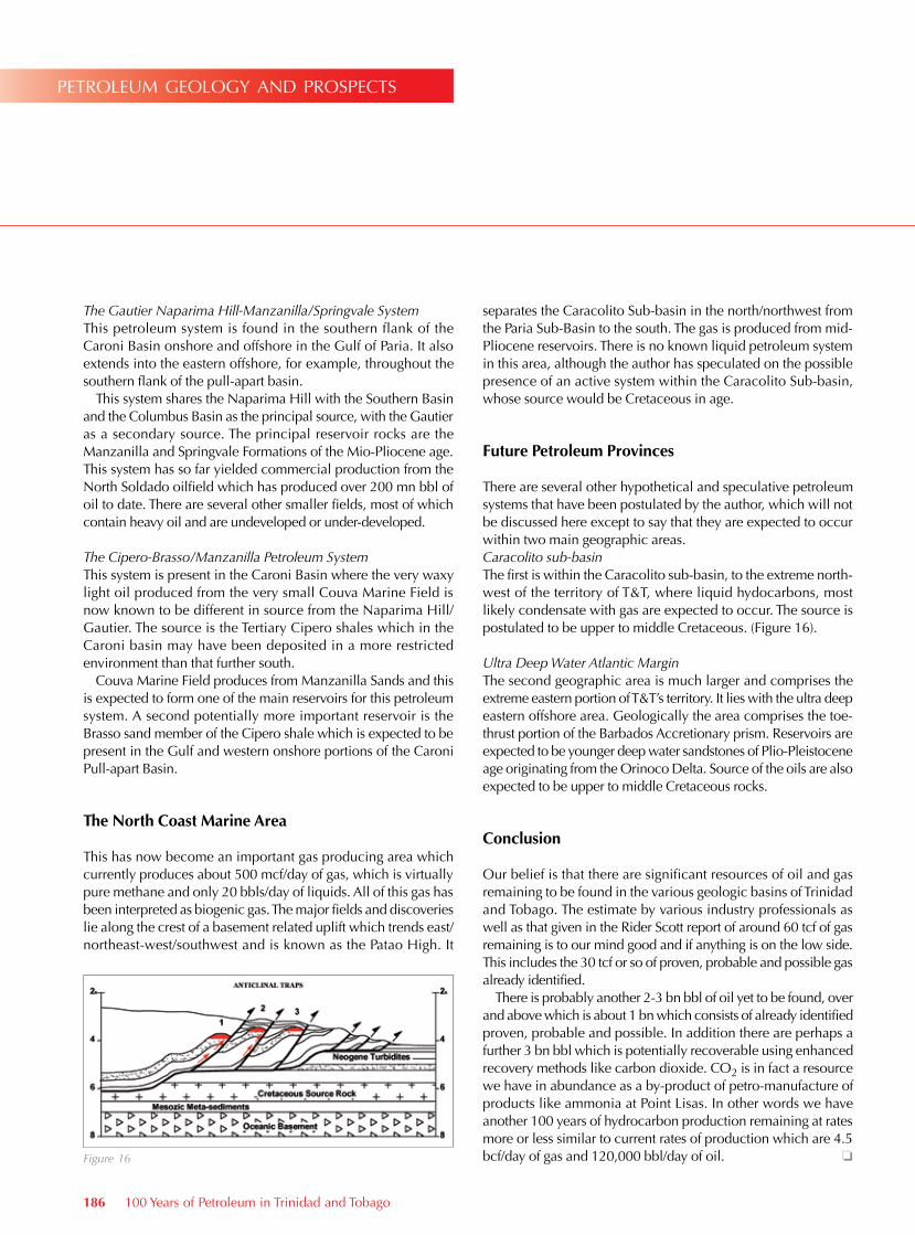
There are several other hypothetical and speculative petroleum systems that have been postulated by the author, which will not be discussed here except to say that they are expected to occur within two main geographic areas.Caracolito sub-basinThe first is within the Caracolito sub-basin, to the extreme north-west of the territory of T&T, where liquid hydocarbons, most likely condensate with gas are expected to occur. The source is postulated to be upper to middle Cretaceous. (Figure 16).
Ultra Deep Water Atlantic MarginThe second geographic area is much larger and comprises the extreme eastern portion of T&T’s territory. It lies with the ultra deep eastern offshore area. Geologically the area comprises the toe-thrust portion of the Barbados Accretionary prism. Reservoirs are expected to be younger deep water sandstones of Plio-Pleistocene age originating from the Orinoco Delta. Source of the oils are also expected to be upper to middle Cretaceous rocks.
conclusion
Our belief is that there are significant resources of oil and gas remaining to be found in the various geologic basins of Trinidad and Tobago. The estimate by various industry professionals as well as that given in the Rider Scott report of around 60 tcf of gas remaining is to our mind good and if anything is on the low side. This includes the 30 tcf or so of proven, probable and possible gas already identified.
There is probably another 2-3 bn bbl of oil yet to be found, over and above which is about 1 bn which consists of already identified proven, probable and possible. In addition there are perhaps a further 3 bn bbl which is potentially recoverable using enhanced recovery methods like carbon dioxide. CO2 is in fact a resource we have in abundance as a by-product of petro-manufacture of products like ammonia at Point Lisas. In other words we have another 100 years of hydrocarbon production remaining at rates more or less similar to current rates of production which are 4.5 bcf/day of gas and 120,000 bbl/day of oil. o
186 100 Years of Petroleum in Trinidad and Tobago
petroleum geology and prospects
Figure 16