the occasional papers - the library of congress occasional papers a philip lee phillips map society...
TRANSCRIPT

i
The Occasional Papers
Maps of Stephen F. Austin: An Illustrated Essay of the Early Cartography of Texas
Series No. 8 A Philip Lee Phillips Map Society Publication
Dennis Reinhartz

The Occasional Papers
A Philip Lee Phillips Map Society Publication
Editorial Staff:
Ralph E. Ehrenberg
Managing Editor
Ryan Moore
Chief Editor, Design and Layout
Michael Klein
Editor
Anthony Mullan
Editor
David Ducey
Copy Editor
Geography and Map Division
Library of Congress
Washington, D.C.
Winter 2015

The Maps of Stephen F. Austin: An Illustrated Essay of the Early Cartography of Texas
Dennis Reinhartz


iii
Foreword
The Philip Lee Phillips Map Society of the Library of Congress is a national support
group that has been established to stimulate interest in the Geography and Map Division’s car-
tographic and geographic holdings and to further develop its collections through financial dona-
tions, gifts, and bequests. The Phillips Map Society publishes a journal dedicated to the study
of maps and collections held in the Division known as The Occasional Papers. This install-
ment focuses on the maps of Stephen F. Austin and early maps of Texas. Maps, such as those
of Austin, have played a key role in the history of exploration, and we hope that this issue will
stimulate intellectual exploration in maps of Texas and the American west. The Library of
Congress’ holdings in these areas are remarkable and many possibilities remain to be discov-
ered.
The paper’s author, Dennis Reinhartz, is uniquely situated to elaborate on the maps of
Stephen F. Austin. For more than three and a half decades, he was a professor of history at the
University of Texas at Arlington, where lectured on the history of cartography, among other
interesting topics. Professor Reinhartz is an active “citizen” in the community of map enthusi-
asts and collectors. Particularly of importance to the Phillips Map Society, Professor Reinhartz
forged relationships with Phillips Map Society founding members Virginia and Jenkins Garrett,
both of whom lent enormous enthusiasm and knowledge to the development of this unique and
amazing friends group of the Geography and Map Division.
The legacy of the late Mr. and Mrs. Garrett is carried on by their daughters, Dianne G.
Powell and Donna K. Garrett. Mrs. Powell serves as Vice Chair of the Phillips Map Society.
She is a knowledgeable collector in her own right and actively promotes the history of cartog-
raphy as a member of the Texas Map Society. Her sister, Ms. Garrett, in 1998, compiled an ex-

iv
tensive cartobibliography of early Texas maps in the collections of the Library of Congress.
The book, Texas: a list of early maps in the Library of Congress and a summary of sources of
current maps, atlases, and geographic information, is held by the University of Texas at Ar-
lington. It is an excellent reference tool for this topic.
Texas is also the home of Phillips Map Society Chair George Tobolowsky. His leader-
ship and interest in maps has helped to grow the Phillips Map Society. Mr. Tobolowsky’s vi-
sion to expand the reach of the Society has spurred us in new and exciting directions. Follow-
ing Ms. Garrett’s work on the cartobibliography of Texas, it was discovered that a number of
maps were in need of conservation, and Mr. Tobolowsky generously donated funds for this pur-
pose. This important step has helped to ensure the longevity of these materials, making them
available for generations to come.
Ralph E. Ehrenberg
Chief, Geography and Map Division

v
Preface
For thirty-five years, I was a member of the history faculty at The University of Texas at
Arlington, from which I retired in 2008. My teaching and research were greatly facilitated by
UTA’s remarkable Virginia Garrett Cartographic History Library. It was through the library’s
holdings and associated special collections that I became aware of and interested in the contri-
bution made by Stephen Fuller Austin to the mapping of both Texas and the United States in
the first half of the nineteenth century.
Over the years, my close personal association with the late Virginia and Jenkins Garrett,
as well as with the historians of Texas cartography J.C. Martin and Robert Sidney Martin, who
were both in their own times directors of special collections at UTA, deepened my interest in
and understanding of Austin. I especially treasured my friendship with Virginia and Jenkins
and am indebted to them many times over; so too are generations of my students at UTA and
those yet to come.
Austin is best known by many as the “Father of Texas,” but what he is less well known for
is his role as the father of modern Texas cartography. In the 1820s, he explored, surveyed, and
was the first to map accurately a major part of the lands what would become the state of Texas.
His cartography had a broader impact, however, as it helped to increase geographic knowledge
of the American West in the first half of the nineteenth century.
I am thankful to the Philip Lee Phillips Map Society for giving me the opportunity to
elaborate upon Austin’s contributions to the mapping of this country.
Dennis Reinhartz
Professor of History, Emeritus
The University of Texas at Arlington


Contents
Foreword by Ralph E. Ehrenberg iii
Preface v
Essay
Introduction 1
Maps before Austin 1
Empresario and Mapmaker 7
The Map that Made Texas 9
Austin-Tanner Map of 1830 13
Conclusion 18
A Brief Comparison of Three Versions of 23
Austin’s 1822 Map
Endnotes 27
Map Figures and Illustrations 29


Maps of Stephen F. Austin

Fig
ure
1

1
Introduction
Stephen Austin's 1822 map Mapa topografico de la provincia de Texas was the first
widely disseminated map to depict Texas that reached an Anglo-American audience. Austin
(1793-1836), known as "The Father of Texas," founded the first Anglo-American colony in the
then Mexican province. At the encouragement of the Mexico authorities, Austin began map-
ping the region that when published, sparked increased Anglo-American immigration, which
eventually resulted in political tensions. When the Mexican authorities and settlers were unable
to reconcile their differences, white settlers opted for a war of independence. During the ensu-
ing conflict, Austin served as a military leader and, following the successful emancipation, ran
for president of the nascent republic. Although Austin lost the election to Sam Houston, Austin
served for two months as secretary of state before his death in 1836.
This paper examines the crude and secret maps of Texas before Austin and then traces
the impact of his maps. I argue that Austin’s mapping was a key element that led to the for-
mation of the Republic of Texas. Included in a separate section is a comparison of three ver-
sions of the 1822 map, which comprised Austin’s original survey.
Maps before Austin
At the time of the Mexican Revolution in 1821, there was a paucity of geographic infor-
mation and cartography about the interior of northern New Spain, a territory that included Tex-
as, California, Arizona, New Mexico, Nevada, and Utah; most of Colorado; and small parts of
Wyoming, Oklahoma, and Kansas. With regard to the rest of the Spanish Empire in the Ameri-
cas, this vast northern frontier remained comparatively underexplored and consequently was
less well understood, colonized, and administered. Figure 1 Scientific mapping of this area

Fig
ure
2

3
was not initiated until the eighteenth century, three hundred years after the first appearance of
the Spanish in this part of the New World. By the early 1700s, the settlement of northern New
Spain was severely hampered by several problems: a lack capital resources; poor governance;
marauding Apache, Navajo, and Comanche tribes; and threats from French, British, and Rus-
sian interlopers.
The new and dynamic Spanish Bourbon Dynasty, whose ascendancy in 1700 had precipi-
tated the War of the Spanish Succession (Queen Anne’s War), almost immediately sought to
reform the crumbling empire it had inherited. One of the most substantial steps was the found-
ing of the Royal Corps of Military Engineers in 1711 by decree of King Felipe V. Although the
king needed to rebuild his “war torn decadent empire” without delay, “it was not until after the
Seven Years War’s [French and Indian War] ended in 1763 in Europe that the Corps became
truly significant on the northern frontier of Spain’s American Empire.”1 The first director gen-
eral of the Corps, a Flemish nobleman, Jorge Próspero de Verboom, established the Royal Mili-
tary Academy of Mathematics in Barcelona in 1711. Cartographic instruction was first detailed
in a royal ordinance of 1718. Thus, these soldier-engineers were to be well schooled not only in
mathematics but in field astronomy and mapmaking, as well.
Near the end of the Seven Years War, France ceded Louisiana to Spain, chiefly to thwart
Great Britain, and thereafter Spanish fears of British penetration of New Spain and Spanish
Louisiana rose substantially. A defensive reorganization of the northern frontier was deemed
necessary. Tours of inspection were undertaken, in which members of the Corps were key par-
ticipants. These efforts yielded extensive reports with attendant accurate maps that offered valu-
able data and observations, which reaffirmed Spain’s claims to the region. Figure 2 They in-
cluded details that were observed directly and mapped precisely, which was an improvement

4
over the previous reliance on guesswork and unconfirmed reports.2 This was the beginning of
an ambitious cartographic initiative that was not completed under the Spanish or Mexican gov-
ernments, but only accomplished by the United States after the Mexican-American War in the
second half of the nineteenth century.
In this last half of eighteenth century, however, thorough exploration and accurate map-
ping was perhaps too little too late for the Spanish and Mexicans to aid significantly in the reor-
ganization, reform, and defense of the northern frontier. The comprehension of the interior of
Texas, for example, was “vague and imprecise,” and what maps existed pertaining to it were
state secrets.3 This policy of concealment was maintained up to the Mexican Revolution, and
much of the later cartography of this period was reflective of this sequestration, particularly of
data concerning the interior.
Encountering this issue was José Antonio Alzate y Ramírez, a Mexican-born cleric, scien-
tist, and member of the French Royal Academy of Science, who published his map of Spanish
North America, Nuevo Mapa Geografico de la America Septentrional…, in Paris in 1768. Alt-
hough as a prominent scholar Alzate had been given entree to Mexican archives, “in the Texas
regions…the map contained little detail and it was in distorted form,” reflecting how little the
official agencies knew about the interior provinces of New Spain.4 Similarly troubled maps
produced by Tómas López de Vargas Machuca, Spain’s most important commercial cartogra-
pher of the second half of the eighteenth century, and his sons are short on detail, due to their
lack of official archival access.5
Vague representations of Texas continued when the great European polymath, Baron Frie-
drich Heinrich Alexander von Humboldt, undertook a scientific expedition to the Americas.
In 1809, he published the report of his journey, Essai Politique sur le Royaume de Nouvelle Es-
5
pagne, and accompanying atlas in Paris, containing his Carte Générale du Royaume de la
Nouvelle Espagne. The English version of the Essai and a somewhat smaller map appeared a
year later in London. Since Humboldt broke off his trip before actually visiting northern New
Spain, his depiction is based solely on older maps such as that of Alzate and on what he found
during brief visits to Spain and Mexico. Humboldt, however, was provided with some material
by President Thomas Jefferson and General James Wilkinson, the governor of Louisiana; in
1804, Humboldt returned the favor by giving Jefferson an early manuscript copy of his New
Spain map. On this adjudged major printed map of the American West, Texas is shown as a
part of the Intendencia of San Luis Potosí with little interior information beyond the coastal
plain.6 Figure 3
American cartographic intelligence about the region of northern New Spain improved
dramatically following a happenstance encounter between an American explorer and the Mexi-
can authorities. The serendipitous incident occurred when Lieutenant Zebulon Montgomery
Pike, who was leading a tour of discovery of the southern reaches of the Louisiana Purchase in
1806-1807, was captured by the Spanish near present-day Pueblo, Colorado and moved via
Santa Fe to Chihuahua. Upon his release, Pike was escorted to Natchitoches, Louisiana Territo-
ry across Texas via San Antonio de Bexar, its new capital. Pike published a full account of his
tour with a description of Texas and several maps in Philadelphia in 1810. Pike’s A Map of the
Internal Provinces of New Spain was based on his own surveillances and information garnered
from his captor Juan Pedro Walker in Chihuahua. He was also privy to the American sources
that were supplied to Humboldt, as well as the map that Humboldt gave to Jefferson. Conse-
quently, Pike’s picture of Texas is far more accurate than Humboldt’s, specifically with regard
to the portrayal of the rivers, but it is still wanting for interior detail.7 Even given this carto-
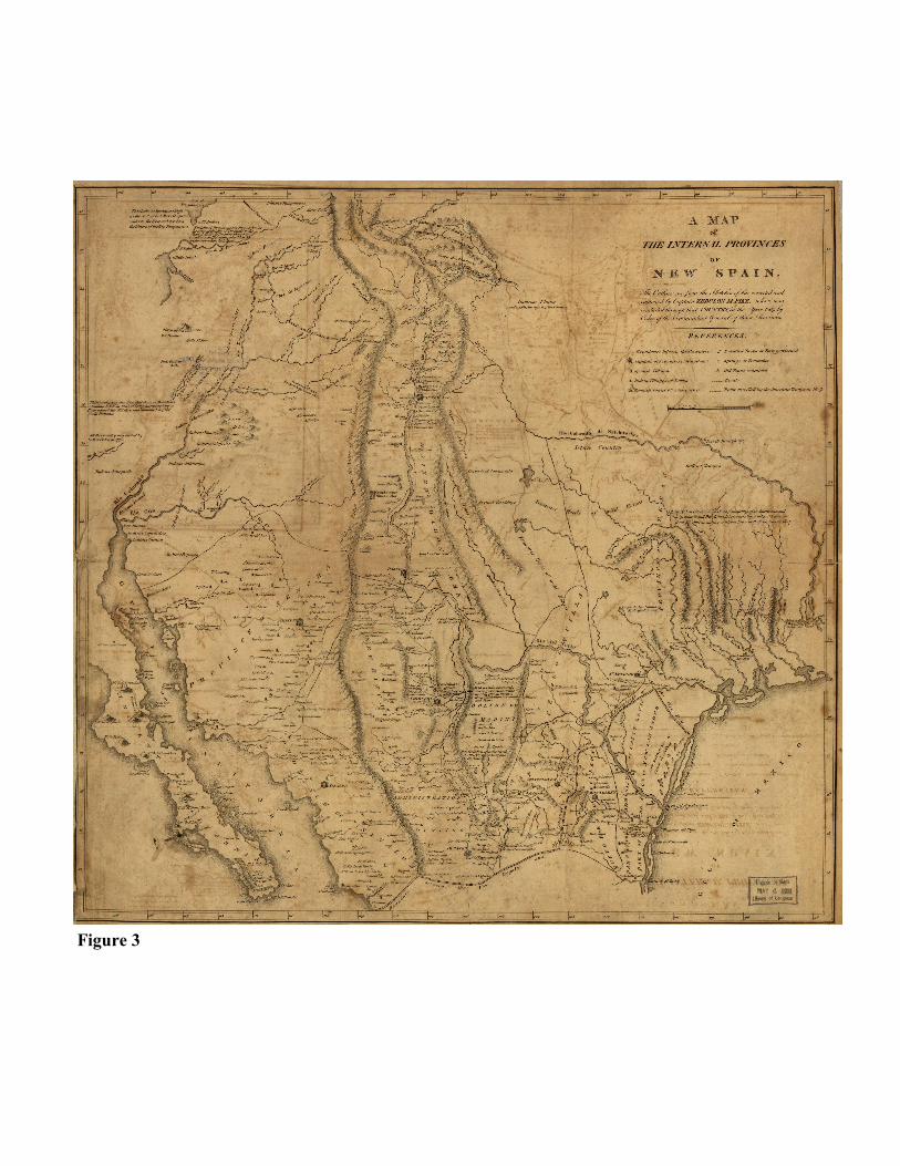
Figure 3

7
graphic record: “When Stephen F. Austin came to Texas in the summer of 1821, he entered a
land that was not only sparsely populated but also generally unknown.”8
Empresario and Mapmaker
Stephen Fuller Austin was born in 1793 to Moses and Mary Brown Austin in Wythe
County, Virginia. This was a mining region where his father was well known in the lead min-
ing business, and his mother came from a mining family. In 1798, Moses moved his family to
Missouri in Spanish Louisiana where he had received a sitio for lead mining. It consisted of a
Crown grant of one Spanish league (4,428 acres) of land on which to settle families for the pur-
pose of extracting lead deposits.
Austin spent his childhood in Spanish Missouri, witnessing firsthand its reclamation by
Napoleonic France and, in 1803, its sale to the United States. Eventually, he became a lawyer
and served in the legislature of Missouri Territory. He was a circuit judge in Arkansas Territory
before moving to New Orleans in 1820.
In the same year, the Spanish government started issuing grants of land to various empre-
sarios or “entrepreneurs” in return for recruiting immigrants to establish communities and to
develop the land within their colonies. Moses Austin received one of the first Spanish grants
for the settlement of Texas. Austin’s substantial grant for 300 colonists (the “Old Three Hun-
dred”) stretched at length to the south and east of present-day Dallas. However, Moses Austin
died at the age of sixty in 1821, and it fell to his son to found Austin’s Colony in what soon be-
came Mexican Texas. Consequently, Stephen had to travel to San Antonio de Bexar in 1821 to
gain official recognition as the heir to his father’s grant. At that time, the population of Texas
numbered about 3,500 people with most of them crowded around San Antonio and La Bahia
8
(Goliad).
Austin explored and mapped the site of his future colony, going so far as to chart part of
the coast and river mouths with soundings from his rented schooner, the Lively, which was later
used to ferry in some of the first colonists. In January 1822, Austin hired one of the settlers, a
surveyor named Nicholas Rightor, to sketch a map of the land between the Brazos and Lavaca
rivers, as Austin continued to explore the coast around the mouth of the Colorado in February.
Shortly thereafter, the new revolutionary Mexican government required that Austin’s grant once
again be reapproved, but this time in Mexico City. Although the Mexican government in the
short term continued the Spanish policy of empresario grants, it nevertheless grew suspicious
that the Anglo-American colonies would lead to American expansion into Mexico.
In preparing his various petitions to the Mexican government, Austin secured a copy of
Mapa de la Provincia de Texas by the Franciscan Father José María de Jesús Puelles in Nacog-
doches in 1807. It became an important source for Austin’s first “rough sketch” map of Texas,
Mapa geographico de la Provincial de TEXAS, por Estevan Austin, 1822, a copy that was filed
with his application.10 Austin’s grant was finally confirmed in April 1823, and in return, proba-
bly to further ingratiate himself, he promised the Mexican government an accurate map of Tex-
as.11 Austin personally was to receive 67,000 acres for every 200 families he brought to live in
the territory. Each adult male colonist was to receive one league of land at the price of thirty
dollars, which was to be paid in full in six years. The General Colonization Law of 1824 ex-
panded immigration and created the state of Coahuila y Tejas as part of the United States of
Mexico.12

9
The Map that Made Texas
Austin’s initial contribution to Texas cartography was the pen-and-ink and watercolor map
of 1822, which he filed during the petition process for recognition of his empresario grant by
the Mexican government. The map extends from near the 104th meridian in the west to the Sab-
ine River in the east and from the 34th parallel in the north to below the mouth of the Nueces
River in the south. The northern and eastern boundaries were roughly those laid out under the
Adams-Onis Treaty of 1819 between the United States and Spain. While the map covers the
area that includes Austin’s grant, the Panhandle and trans-Pecos regions of the present-day state
of Texas are absent. The various rivers, which are so important in the history of Texas, are
placed appropriately, and their lengths were approximated. Beyond his own observations and
research, Austin’s depiction of eastern Texas reflects his debt to Humboldt and Pike, as does the
representation of some of the Texas coast to Puelles. Many towns, settlements, presidios
(fortified military settlements), Native American villages, and the roads linking them also are
shown. In between the lower Brazos and Colorado rivers, Austin labeled his then soon to be
approved grant “Austiana, or Austin’s Settlement.”13 Figure 4
Rivers are the most conspicuous geographical features on Austin’s map and are demar-
cated accurately. Generally flowing from the northwest to the southeast, the river systems of
the Rio Grande, Nueces, Colorado, Brazos, Trinity, and Sabine, among others, seem to pro-
claim the farming and ranching possibilities of Texas and especially the lands of the Austin’s
Colony. They also can be seen as potential arteries of communication and commerce, leading
to and from the Gulf of Mexico, as well as between towns and settlements.
Several important land routes are indicated across the map that mostly cut in an east-west
direction. The central road, “Camino que va a Natchitoches,” proceeds from “Laredo” in the

Figure 4

11
southwest through “Bexar” (San Antonio) and Nacogdoches to Natchitoches in Louisiana. A
southern road “Camino de va a los Opeluzas,” leads again from “Laredo” through “La Bahia”
to Opelousas in Louisiana. And coming from the northwest to intersect the Natchitoches road
is the “Camino de Comanches,” the famous Comanche Trail first laid down by migrating Na-
tive Americans.
As alluring as this map might be to prospective immigrants with its water resources, roads,
and towns, it was marked conspicuously with the looming presence of Native Americans. Just
below the Lipan Apaches in the northwest of the province, the Comanches dominate the map.
In the second half of the eighteenth century, these two tribes formed a persistent threat to the
settlements on the northern frontier of New Spain that continued under the Mexican republic.
On the coast of the Gulf of Mexico, the “Carancahuas” (Karankawas), who Cabeza de Vaca
believed were cannibals when encountered three hundred years before, are shown. Across the
east the friendlier “Cado,” “Cochata” (Coushatta), “Alabama,” and others also are indicated.
And evident on the upper “R. Níeves” there is a village of the “Texas” (Tejas), the people after
whom the province and future republic and state were named. With this prominent representa-
tion of Native Americans in Texas, especially the Comanche, Austin was perhaps trying to in-
fluence the Mexican government to safeguard his settlement from the Native Americans.14
Figure 5
Although Austin was not a trained cartographer, the significance of Austin’s 1822 map of
Texas cannot be discounted. Firstly, it was the most comprehensive and current depiction of
the province of Texas to date. The Spanish and Mexican administrations simply had nothing
like it. Secondly, since it existed in multiple contemporary copies, the information it held be-
came public knowledge quickly.15 Finally, the 1822 map also laid the groundwork for Austin’s

Fig
ure
5

13
far more influential map of 1830. The 1822 map and Austin’s cartography of Texas that fol-
lowed quite possibly helped to endear him and his empresario venture to the Mexican govern-
ment, and conceivably serves as an explanation as to why in 1830 further American coloniza-
tion of Texas was proscribed, but the Austin colony was permitted to remain.
The Austin-Tanner Map of 1830
Austin compiled data and worked on the map he had promised the Mexican government
throughout the later part of the 1820s. Under his grant he was required to survey his colonists’
tracts of land. He hired surveyors to perform the actual work, and some of the plats and the cor-
respondence relating to them survive in his collected papers at The University of Texas at Aus-
tin. So too survives his petition to the Mexican government of February 1825 to build a port on
Galveston Island in order to facilitate communications, colonization, and trade. In response, he
was commissioned to survey the island, which he did, submitting his report with a map in
March 1826.16 Afterwards, a map known as TEXAS appeared in Mexico City in 1826. The
lithographic map made by Fiorenzo Galli and published by Claudio Linati was based substan-
tially on Austin’s map of 1822. The only extant copy survives at the Barker History Center at
The University of Texas at Austin. It is important for being the first printed map of the re-
gion.17
Finally, drawing on numerous and diverse sources, Austin began working in earnest on his
map in 1827, just when the Anglo colonization of Texas was becoming a major point of conten-
tion in Mexico City. Consequently, Manuel de Mier y Terán was sent to explore East Texas in
1828 to report on the growing American influence there. Terán had experience in such matters,
as he was the Mexican co-leader of the American-Mexican commission that scrutinized the bor-

14
der between the two countries in 1827. Terán’s rather dire account, citing expanding American
influence, to Mexican president Guadalupe Victoria stimulated the passage of the law of 1830
that prohibited further American immigration into Texas. Terán brought with him the copy of
the Galli map that survives, and it is profusely annotated in its margins.18 He apparently drew a
map of his own, based on Galli’s map, to submit with his final report, but it does not seem to
exist any longer. Some of its information, however, does endure on Austin’s map of 1830.
Terán and Austin became “well acquainted” in the new town of San Felipe de Austin, sharing
geographical information and perhaps Galli’s map Texas at this time. Terán became one of the
most important sources for Austin’s map. Undoubtedly to add to its verity, Terán is the only
source listed on the published Austin-Tanner map of Texas of 1830-1840.19
Austin finally completed his map in the summer of 1829. The previous year, however,
Austin, through a relative in Philadelphia, the attorney Thomas F. Leaming, had already ap-
proached the prominent Philadelphia publisher Henry S. Tanner to print and distribute the map.
Tanner was eager to publish it, which he did in 1830, and it became the second printed map of
Texas. Austin sent a copy of his manuscript map first through Leaming to Tanner in June
1829, and a month later he sent a copy in Spanish to the Mexican President Vicente Guerrero,
thereby fulfilling his 1823 promise to his adopted country. The copy sent to Tanner was heavi-
ly annotated, especially with regard to resources (e.g. salt), population, and topographical de-
scriptions.20 He also sent copies to the ayuntamiento (municipal council) of San Antonio de
Béxar (which had high praise for it and its author) and Terán. He retained a copy for himself.
Only the Mexican government and Austin’s personal manuscript copies still exist, and they can
be found in Mexico City and at The University of Texas at Austin, respectively.21
Originally, Tanner’s finely engraved (by John and William W. Warr) and tastefully col-

15
ored 1830 edition of the 76 x 60 cm. Map of Texas with Parts of Adjoining States (1:1,500.000)
was issued as a more expensive pocket map that would be especially user-friendly for immi-
grants to Texas. The popularity of pocket maps dates back to at least the second half of the sev-
enteenth century, and this format was created essentially to satisfy the demand created by in-
creasingly mobile middle class Europeans. Pocket maps were constructed from evenly dissect-
ed sheet maps; the sections were affixed to cloth or canvas backings (the Austin-Tanner map is
in twelve such parts); and they were folded along the gaps between the sections to fit in the
more confined spaces of luggage or the coat pockets of travelers. Pocket maps often were fitted
with titled covers made of leather or other more rigid materials, which prolonged the life of a
given map and allowed users to easily consult them during travel. In due course, the use and
increased acceptance of pocket maps crossed the Atlantic to the Americas with the European
empires and their journeyers. The Library of Congress has a copy of the 1837 edition, but it is
not a pocket map.22 Figure 6
The Austin-Tanner map was a financial success, and it was followed by updated versions in
1833, 1835, 1836, 1837, 1839 and in 1840 in Francis Moore, Jr.’s Map and Description of Tex-
as, published by Tanner. However, the publisher feared competition and would not let Austin’s
cousin, Mary Austin Holley, use it in her book, Texas: Observations, Historical, Geographical
and Descriptive, which as an early example of boosterism for Anglo-American settlements.23
As might be expected, the 1830 map covers essentially the same area and topography as
the 1822 map. The Red River is clearly the northern boundary. To the southwest the Mexican
states of “CHIHUAHUA,” “TAMAULIPAS,” and “NEW LEON” have come to join
“COAHUILA” and “N. SANTANDER” of the 1822 map. Across the west and the north of
Texas, prairies are shown. “IMMENSE HERDS OF BUFFALO” (part of the now vanished

Figure 6

17
great southern herd) and “IMMENSE DROVES OF WILD HORSES” (left over from the Span-
ish) are said to be populating those vast grasslands, which are part of the southern extension of
the Great Plains. Newly added and labeled is the mixed scrub forest of the “CROSS TIM-
BERS” in north central Texas in what became the Dallas-Fort Worth metroplex. Some of the
information from the annotations on Austin’s 1829 manuscript map sent to Tanner have made it
onto the printed version. Thus, in the state of Tamaulipas, south of the Nueces River below the
“Salt Lakes,” it is indicated on that map that “the Salt Crystalizes in the Bottom of these Lakes
in Strata 4 to 6 inches thick. Large quantities are annually taken away without producing any
scarcity.”
Of all the empresario grants, only “AUSTIN’S COLONY” and the neighboring “DE
WITT’S COLONY” (which Austin helped to establish) to the southwest are demarcated. The
advancement of settlement to 1829 is apparent. The new hamlets of Brazoria, Gonzales, Harris-
burg, San Felipe de Austin, and Victoria appear on the map for the first time, as do some of the
roads linking them, but there are few communities and traces west of San Antonio or north of
Waco on the Brazos River. The locations of the Comanche, Caddo, Coushatta, and other tribes
are marked in a much less ominous fashion than they were on the 1822 map.
An interesting decorative feature of the map is a golden eagle clutching a rattlesnake in its
beak just above a prickly pear cactus. This symbol of the Mexican republic dates back to the
Aztecs, perhaps even further, and was appropriated by revolutionary Mexico. Above the eagle
is the cap of “LIBERTAD,” radiating like a sun across Mexico and the world. The eagle proud-
ly and defiantly holds a banner, bearing the name of the “REPUBLICA FEDERAL MEXI-
CANA” in its talons. The paddles or “tunas” of the cactus are each labeled with the name of a
Mexican state (“Coahuila y Tejas” is at the top, directly under the eagle), while at the base of

18
the cactus further symbols of Mexico’s Native American heritage
are to be found.24 Figure 7
In the lower left corner of the map, at the southern end of an
identified “GRAND CHAIN OF MOUNTAINS,” there is a note de-
scribing Mexico to Saltillo (Leona Vicario), the capital of the state
of Coahuila y Tejas since 1824. On post-1830 editions, it is fol-
lowed by a further annotation that lists the numbers of families allo-
cated to some of the empresario grants, including Austin’s. Also
explained is the holding each colonist family head is to receive and
the conditions that must be met under Mexican law to retain the allotment.
Conclusion
Austin’s cartography greatly impacted the exploration and settlement of the American
West. Austin’s maps readily met one of the principal demands leading to their creation: they
provided accurate geographical data to facilitate the management of the empresario grants and
for the commercial development of the land now known as Texas. In so doing, they also
helped to underscore the economic potential of Mexico to its immigrants and administration.
This is certainly the case with the Austin-Tanner map 1830, because of its the widespread
circulation and popularity. It rapidly increased Anglo-American immigration to Texas and at
the same time aroused the Mexican government’s fears of growing American influence. It is
clear that Austin intended the map to be a stimulus for immigration, but he hoped that the Mex-
ican government, at least initially, would not see it that way. To a large extent, he was right;
the government had not expected the intensified immigration in response to the map.25 But
Figure 7

19
once the Mexican authority understood the situation, it countered swiftly and harshly, causing
widespread discontent among the majority Anglo-American population of Texas, leading to the
Texas Revolution in 1835 and subsequent formation of the Republic of Texas in 1836. The in-
dependence of Texas and its annexation to the United States a decade later were major causes
of the Mexican-American War of 1846-1848. Austin, however, did not live to see the largely
unintentional broader consequences related to his cartography.
The significance of Austin’s 1830 map stretches beyond its political legacy. It was the
most detailed and accurate map of Texas to date; moreover, it was the model and source for
Texas cartography for more than a decade and a model for immigrant maps for even longer.
For example, the influential map TEXAS by David H. Burr, geographer to the U.S. House of
Representatives and topographer to the U.S. Post Office, published in New York in 1833 was
derivative of Austin’s map and updated it. Burr also went beyond Austin to show seventeen
empresario land grants.26 Thomas Gamaliel Bradford’s TEXAS, published in his A Comprehen-
sive Atlas, Geographical, Historical and Commercial in New York in 1835, drew on Austin’s
map and reflected its consequences by depicting the surfeit of new settlements created by the
waves of immigrants stirred on to Texas by Austin’s map.27
The mapping program of the United States government also was affected by the Austin-
Tanner map. Presumably relating to hydrographic drainage study, in 1839 E. Gilman, a rela-
tively prolific draftsman for the General Land Office in 1837-1850, produced an excellent ink
and watercolor manuscript copy (53 x 41 cm.) of the Austin-Tanner map minus everything but
the river systems, which is now in the collection of the Library of Congress.28 Figure 8 Wil-
liam H. Emory, a young U.S. Army topographical engineer with an exceptional cartographic

Figure 8

21
future, still listed Austin’s map as a source for his MAP OF TEXAS AN D THE COUNTRIES
ADJACENT…, published in New York in 1844.29

Fig
ure
9

A Brief Comparison of Three Versions of
Austin’s 1822 Map


25
Several copies of the Stephen Austin 1822 survey map survive. Enough variation be-
tween them warrants a brief comparative examination. The differences among them is traceable
to the fact that some maps were copied by acquaintances to Austin or by those in his employ.
Discussed herein are copies at the University of Texas at Austin, The National Archives, and
The Library of Congress.
A copy at The University of Texas at Austin (36 x 61 cm.) is believed to be one sent by
Austin with his grant application to the Mexican government or a very close duplicate of it.
Longitude and latitude are indicated on two of the four sides. Arable and timbered lands are in
green, whereas “Prairie” is depicted in yellow. The land is called “TEHAS” and Austin refers
to himself as Don Esteban Austin. His settlement is prominently labeled as “Austina.” Distanc-
es are measured in “leguas” a Spanish unit of measurement, which was understood as the dis-
tance a person could walk in an hour.
The National Archives holds a slightly tattered around the edges specimen titled, Mapa
Geografico de la Provincial de Texas. Don Estevan Austin lo formó, y el Tesorero y Comisario
de Guerra de la Novena Division del Ejercito Ymperl. Mexicano D. Aniceto Ortiz de Guzman lo
copio para El Excmo. Sor. Dn. José Dominguez. It was copied for the Mexican Minister of Jus-
tice José Dominguez Manso c. 1822, by a Mexican army officer and plainly suggests a trained
hand. The official symbol of the Mexican government is prominently displayed in the lower
right corner. Since the map, like the Library of Congress copy, was meant for Mexican govern-
ment internal use. The Austin colony is not represented. The map is situated within a grid and
longitude and latitude are indicated on all four sides. The map’s history is interesting. It was
confiscated by the American army of occupation after the Mexican-American War and brought
to the United States in 1848. Figure 9

26
The Library of Congress has a copy titled Mapa topografico de la provincial de Texas.
Dn. Estevan Austin lo formo. The 26 x 35 cm. exemplar (1:3,000,000) was accessioned by The
Library in 1928. It is possibly the copy sent to Anastacio Bustamante, Captain General of the
Interior Provinces, on May 10, 1822 by Austin with comments on how to deal with current Na-
tive American problems in Texas. While its provenance is unknown, it perhaps was made by a
Spanish draftsman with more of a scientific background than Austin, as hinted by the substitu-
tion of “topografico” in its title for the “geographico” of the Austin original. The indications of
longitude and latitude around all for sides of the Library of Congress copy. In the bottom mar-
gin it is specified “Longitud a Londres,” that its prime meridian for these measurements is Lon-
don (Greenwich). In the top margin of the map is stated “Longitud de Washinton,” demonstrat-
ing that these extents are based on the Washington, D.C. prime meridian. Just to the right of
this indication are two more marks, “N.23.” and “V.28.” These might be dates or perhaps some
sort of administrative numbers, which may in turn be related to another annotation in the right
margin that seems to have faded and is undecipherable. Furthermore, in the bottom margin of
the Library of Congress copy it is written that “El color verde indica bosques y margenes de
rios; el amarillo, llanoes; y las pintas roxas, rancherias de indios.” This translates to mean:
“The color green indicates groves and margins of rivers; the yellow, plains; and the red sites,
Indian villages.” It is worth noting that a similar statement also appears below the title in the
lower left corner on the National Archives copy, but there are no pigmentation references on
the earlier map. Understandably, the palettes of the Library of Congress and National Archives
copies are much alike, but the color coding coupled with its better condition helps to make the
Library of Congress copy particularly attractive.

27
Endnotes
1. Janet R. Fireman, The Spanish Royal Corps of Engineers in the Western Borderlands: In-
strument of Bourbon Reform 1764 to 1815 (Glendale, CA: The Arthur H. Clark Company,
1977), 27.
2. For more on the work of the Corps in New Spain, see: David Buisseret, “Spanish Military
Engineers in the New World before 1750” and Dennis Reinhartz, “Spanish Military Map-
ping of the Northern Borderlands after 1750” in Mapping and Empire: Soldier-Engineers
on the Southwestern Frontier, eds. Dennis Reinhartz and Gerald D. Saxon (Austin: Univer-
sity of Texas Press, 2005), 44-56 and 57-79, respectively.
3. Robert S. Martin, “Maps on an Empresario: Austin’s Contribution to the Cartography of
Texas,” Southwestern Historical Quarterly LXXXV-4 (April 1982), 371. I am particularly
thankful to Bob Martin for giving me a reprint of this substantial piece of Austin scholar-
ship thirty years ago and most especially for helping me into the history of cartography
4. James C. Martin and Robert Sidney Martin, Maps of Texas and the Southwest, 1513-1900
(Austin: Texas State Historical Association, 1999 [1984]), 101. Albeit printed from an en-
graved copper plate, Alzate’s map may have had limited distribution, and it remains rather
rare today.
5. For other examples see: Tómas López y Vargas Machuca, Atlas geografico de la América
septentrional y meriodional…, (Madrid: 1758).
6. Martin and Martin, 109; Dennis Reinhartz, “Alexander von Humboldt, His Earliest Surviv-
ing Map of New Spain,” IMCoS Journal 116 (Summer 2010), 13-18.
7. Martin and Martin, 111; Dennis Reinhartz, “Ambition and Enterprise: Zebulon Pike’s
Maps Relating to the Exploration of the Southern Louisiana Purchase,” IMCoS Journal 103
(Winter 2005), 25-37.
8. Robert S. Martin, 371.
9. Robert Sidney Martin and James C. Martin, Contours of Discovery: Printed Maps Delineat-
ing the Texas and Southwestern Chapters in the Cartographic History of North America,
1513-1930. A User’s Guide (Austin: The Texas State Historical Association, 1982), 24.
10. Copies of this map exist in the collections of the National Archives of the United States
(Records of the Office of the Chief of Engineers, Records Group 77 Q 38), Geography and
Map Division of The Library of Congress (G4030 1822 Vault .A9 TIL), Witte Museum in
San Antonio, and The University of Texas at Austin.

28
11. Robert S. Martin, 373-383.
12. For a map-related overview of this settlement of Texas, see: Richard Bruce Winders,
“Colonization 1821-1836” in Going to Texas: Five Centuries of Texas Maps (Fort Worth:
Texas Christian University Center for Texas Studies, 2007), 31-40.
13. Robert S. Martin, 379; also, see: Carlos Castañeda and Early Martin. Jr., Three Manuscript
Maps of Texas by Stephen F. Austin (Austin: privately published, 1930), 12-13 and Martin
and Martin, Contours of Discovery, 46-47.
14. Robert S. Martin, 388-389.
15. Ibid., 383.
16. See: Eugene C. Barker (ed.), The Austin Papers, 3 vols. (Washington, DC: 1924-1928).
17. Robert S. Martin, 387- 389; Martin and Martin, 118-119.
18. Martin and Martin, 119.
19. Robert S. Martin, 385-390.
20. Castañeda and Early, Jr., 35-37.
21. Castañeda and Early, Jr., 18-24; Robert S. Martin, 390-395; Martin and Martin, 121; and
Martin and Martin, Contours of Discovery, 47-48.
22. Library of Congress, Geography and Map Division, G4030 1837 .T3 Vault.
23. Robert S. Martin, 395-396.
24. Dennis Reinhartz, The Art of the Map: An Illustrated History of Map Elements and Em-
bellishments (New York: Sterling Publishing, 2012), 29.
25. Martin and Martin, 121.
26. Ibid., 123. Interestingly, in Texas map collecting circles, Burr’s map is almost as sought
after as Austin’s map.
27. Ibid., 125.
28. See: E. Gilman, No. 3. Sketch of Texas, with the Boundaries of Mexican States, as shown
on Genl. Austin’s Map of Texas, Published by H.S. Tanner, 1839. G4030 1839 .G5 TIL
Vault.
29. Martin and Martin, 129.

29
Map Figures
Figure 1 Nicolas de Fer, Les costes aux environs de la rivière de Misisipi: découvertes par
Mr. de la Salle en 1683 et reconnues par Mr. le Chevallier d'Iberville en 1698 et
1699, ([Paris? : s.n.], 1701), Library of Congress, G4042.M5 1701 .F4. French map
of the lower Mississippi Valley that illustrates the paucity of information about Tex-
as at the turn of the eighteenth century. Interestingly, the map commemorates La
Salle’s failed attempt at establishing a French colony on the Texas coast that was
intended to counteract Spanish influence in the area.
Figure 2 Jose de Urrutia and Nicolas Lafora, Mapa, que comprende la Frontera, de los
Dominios del Rey, en la America Septentrional, ([s.n.], 1769), Library of Congress,
G4410 1769 .U7 TIL Vault . A large and beautifully drawn map of Northern New
Spain accompanying the report of a Spanish survey for reorganizing defenses along
the northern frontier to guard against British expansion and Indian raiders.
Figure 3 Zebulon M. Pike, A map of the Internal Provinces of New Spain, (Philadelphia,
1810), Library of Congress, G4295 1807 .P5 TIL. Information on this map was
based on Pike’s personal reconnaissance of the region, communication with his
Spanish captor, and a manuscript copy of a map of New Spain prepared by Alexan-
der Humboldt for the War Department. Although viewed as a slight improvement
over Humboldt’s earlier map, much of the cartographic information is generalized
and inaccurate.
Figure 4 Stephen F. Austin, Mapa geographico de la Provincial de TEXAS, por Estevan Aus-
tin, 1822, ([s.n.], 1822). This is the map Austin enclosed with his petition to the
Mexican government to legitimize his empresario grant, and includes his own obser-
vations and research, especially for eastern Texas. Courtesy of the Briscoe Center for
American History, the University of Texas at Austin
Figure 5 Detail of the 1822 Austin map in the Library of Congress placing emphasis on the
village of the Texas people, for whom the state was eventually named.
Figure 6 Stephen F. Austin, Map of Texas with Parts of Adjoining States (Philadelphia: Henry
S. Tanner, 1837). Although not published as a pocket map, this edition resembles the
kind of map that would have been used by immigrants or travelers to Texas. Library
of Congress, Geography and Map Division, G4030 1837.T3 Vault.
Figure 7 Detail of the 1837 Austin/Tanner Map of Texas showing its elaboration on the symbol
of the Mexican Republic, with its liberty cap, the banner in its talons, and cactus
paddles, each containing labeled with the name of a Mexican state.
Figure 8 E. Gilman, Sketch of Texas with the boundaries of Mexican States as shown on
General Austin's map of Texas published by R. S. Tanner, 1839 (1839).
Library of Congress, Geography and Map Division, G4030 1839 .G5 TIL Vault.

30
Figure 9 Stephen F. Austin, Mapa Geografico de la Provincial, ([s.n.], ca. 1822). The map
was copied by a Mexican army officer for the Mexican government but confiscated
by American troops after Mexican-American War in 1848. National Archives and
Records Administration, Records Office of the Chief of Engineers, Record Group
77: Civil Works Map File; Q-38.
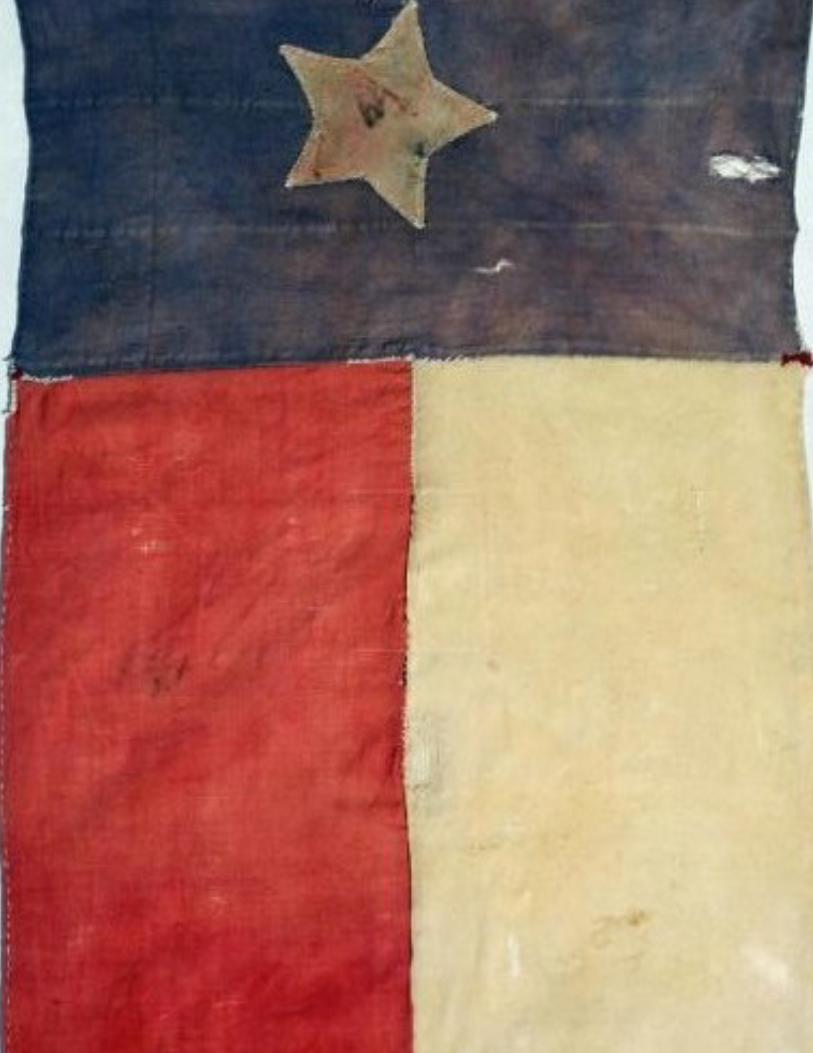
Back Flag of the Republic of Texas, from WikiCommons.

The Philip Lee Phillips Map Society of the Library of Congress is named in honor of
Philip Lee Phillips (1857-1924), the first Superintendent of Maps at the Library of Congress when
the Hall of Maps and Charts was established in 1897.
The group is a non-profit, voluntary association whose objective is to develop, enhance,
and promote the work of the Geography and Map Division by advancing its publication, educa-
tion, exhibition, preservation and acquisition programs.