the new catalogue of italian tsunamis - ingv - dati ... · the new catalogue of italian tsunamis...
TRANSCRIPT

Natural Hazards 33: 439–465, 2004.© 2004 Kluwer Academic Publishers. Printed in the Netherlands.
439
The New Catalogue of Italian Tsunamis
STEFANO TINTI1,�, ALESSANDRA MARAMAI2 and LAURA GRAZIANI2
1Dipartimento di Fisica, Settore di Geofisica, Università di Bologna, Viale Carlo Berti Pichat, 8 –40127 Bologna – Italy; 2Istituto Nazionale di Geofisica e Vulcanologia, Via di Vigna Murata 605 –00143 Rome – Italy
(Received: 11 February 2003; accepted: 19 January 2004)
Abstract. A new Italian tsunami catalogue (ITC) is presented here. It contains 67 events, coveringthe period from the tsunamigenic Plinian eruption of Vesuvius (79AD) until today. It is the result ofintense scrutiny of the original sources of data, and integrates and updates the tsunami catalogue byTinti and Maramai (TMC) published in 1996. With respect to the TMC, six new events have beenadded and six have been eliminated, while the 61 events common to both catalogues have been allre-examined and re-evaluated. The ITC fits the criteria adopted for the catalogue of tsunamis in theEuropean region in the framework of the EU projects GITEC (1992–1995) and GITEC-TWO (1996–1998). It is in the form of a digital database, that was implemented through the Visual FoxPro 6.0DBMS with the main purpose of building a rigorous and easy-to-use working tool for scientists aswell as for people involved in hazard and risk reduction in coastal areas. Through the main cataloguescreen, the user is allowed to browse the database and to get all the information concerning a selectedevent (occurrence date, cause, detailed description, references, etc.). Furthermore, by means of func-tional buttons, the user can perform data extractions according to several key combinations (date,generation, sub-region, tsunami intensity, cause, etc.) and also access the related database of thereferences containing about 230 entries. In addition to data in the form of text, the ITC also includesa gallery of images documenting tsunami damage and a unique set of analogue tide-gauge records. Afurther section of statistics provides space and time distribution of the events, tables and histograms.The catalogue is available at the INGV web site http://www.ingv.it/italiantsunamis/tsun.html and canbe freely downloaded.
Key words: Catalogue, digital database, Italy, statistics, tsunamis.
1. Introduction
Catalogues of tsunamis in the European seas have been assembled since the 1960s,first in the form of regional compilations (see papers by Galanopoulos, 1960, ontsunamis in Greece, and by Ambraseys (1962), on tsunamis in the Eastern Mediter-ranean), and then with a broader view (e.g., Antonopoulos, 1990; Soloviev, 1990,and Soloviev et al., 2000, on tsunamis in the Mediterranean sea). In the 1990s theidea of assembling a catalogue covering all European tsunamigenic zones, whichused the same criteria for the interpretation of historical sources, parameter estim-ation and data presentation, was conceived and implemented by a special workinggroup created in the frame of the European Union projects GITEC (Genesis and
� Author for correspondence. E-mail: [email protected].
440 STEFANO TINTI ET AL.
Impact of Tsunamis on the European Coasts) and GITEC-TWO (Genesis and Im-pact of Tsunamis on the European Coasts – Tsunami Warning and Observations).The final result of their work was the first digital database of European tsunamis(Tinti, 1993; Tinti et al., 1999a). Version 1.1 of the database was released in Oc-tober 1998 under the name “GITEC Tsunami Catalogue” (see GITEC-TWO FinalScientific Report, 1999).
The first compilation of Italian tsunamis is mainly due to the tenacious workof Caputo and was published in the 1980s (Caputo and Faita, 1984; Bedosti andCaputo, 1986). That work had the relevant merit of outlining the significance of thetsunami problem for Italy. It showed that Italy is the second country of Europe afterGreece to be affected by damaging tsunamis. But it had a notable drawback: datacollection had been carried out by the authors deliberately with scarce analysis ofthe sources, since the prevailing logic was to gather as much material as possibleand to leave the job of data scrutiny and interpretation to the reader. The effectwas that more than 150 entries were included in the catalogue. A decade later,Tinti and Maramai (1996) applied the same criteria that were being establishedfor the European GITEC catalogue to the Italian data. Their basic philosophy wastotally diverse from Caputo et al.’s work, since it was based on the concept thatone of the chief tasks of the compilers is to filter raw data by means of a priorminute examination of the sources. This careful examination led to a compilationof only 67 events, with the elimination of many entries of the previous cataloguedue to a variety of reasons (double events, false events, etc.). The Italian tsunamicatalogue presented in this paper (ITC for short) is the result of the research thatwas undertaken in the years since the end of the European project GITEC-TWO,and should be viewed as the continuation and completion of the studies that werethe basis of the 1996 Tinti and Maramai catalogue (TMC).
2. What is a Tsunami?
It is not our intent to provide a general-purpose definition of a tsunami, but onlyto specify the definition that was adopted for compiling the ITC: “Tsunami is aseries of sea waves generated by a large-scale source that can be 1) the suddendisplacement of the sea floor due to tectonic dislocation, or 2) the motion of a bodysliding along the sea floor”. This means that basically the accepted primary tsunamicauses are earthquakes and landslides, either entering the sea from the coast orstarting underwater. On the other hand, volcanic activity is also taken into accountas a possible tsunamigenic source since it may be associated with seismic shocks,the failure of a volcanic edifice (flank or caldera collapse), or with tsunamigenicpyroclastic flows or surges.
It is opportune to clarify that “large-scale” tsunamigenic sources are here con-sidered those sources capable of exciting long water waves with periods in theorder of tens of seconds or more. Though the above definition may appear eithertoo generic or too trivial, nonetheless it serves as an effective criterion to decide
THE NEW CATALOGUE OF ITALIAN TSUNAMIS 441
whether an event can be considered worthy of inclusion in the catalogue or not. Inparticular, attention is drawn to two categories of events that do not fit the ITCtsunami definition: (1) water waves generated by meteorological perturbations;(2) water waves excited by tsunamigenic-like sources in water basins other thanthe sea. Storm surges are the most common mechanism of large-amplitude seawave generation, but these cannot be considered a tsunami since their period issmaller than 15 sec. However, fast moving large-scale atmospheric depressions arecapable of exciting long water waves and seiches in coastal basins that possesshydrodynamic features not significantly different from tsunamis. Therefore, someresearchers like calling them meteorological tsunamis. See Rabinovich and Mon-serrat (1996, 1998), for cases recorded in the Balearic Islands. As to the secondclass, closed basins like lakes and coastal lagoons are known to be as affectedby earthquakes and mass slides as the open sea. Usually earthquakes excite thelow-frequency eigenmodes of oscillations of the basins, while mass instabilitiesproduce smaller-scale, but larger-amplitude waves that can also be catastrophic.
In Italy, ice-falls in glacial lakes (e.g., the lethal ice detachment that occurred in1996 in the Miage glacier described by Tinti et al., 1999b), rockfalls, and slumps inalpine lakes are not rare events. One of the most tragic events that ever occurred inthe recent history of Italy is the Vajont catastrophe. On 9th of October 1963 a hugerockslide detached from Mount Toc filling the reservoir formed by a dam in theVajont valley. The enormous splash almost emptied the lake displacing most of itswater beyond the dam, which resisted the impact. The water was channelled viol-ently into the narrow valley downstream from the dam and soon reached the largevalley of the Piave river where it swept out several villages. The flood destroyedalmost everything along its path killing more than 2000 people (see the thoroughreconstruction by Hendron and Patton, 1985).
Since neither meteorological seiches nor water waves produced in lakes fulfilthe tsunami definition we have adopted here, the ITC does not include events of thiskind. But we are conscious that they deserve proper attention both by scientists andby people involved in protection from natural hazards.
The final remark of this section regards waves generated by the impact ofmeteorites on the ocean. No such cases have ever been recorded in the world inhistorical times, though evidence of catastrophic inundations attributable to thecrash of extraterrestrial objects on our planet in geological times is abundant (seeToon et al., 1997); hence, whether or not our tsunami definition embraces thismechanism is totally inconsequential for the ITC.
3. The Basic Structure of the Catalogue
The Italian Catalogue of Tsunamis is a digital data base that was built by meansof the Microsoft Visual Foxpro 6.0 Database Management System (DBMS) andruns on PC platforms Windows 95, Windows 98, Windows 2000 as well as thelatest Windows operating systems. It contains data on 67 tsunamis affecting the
442 STEFANO TINTI ET AL.
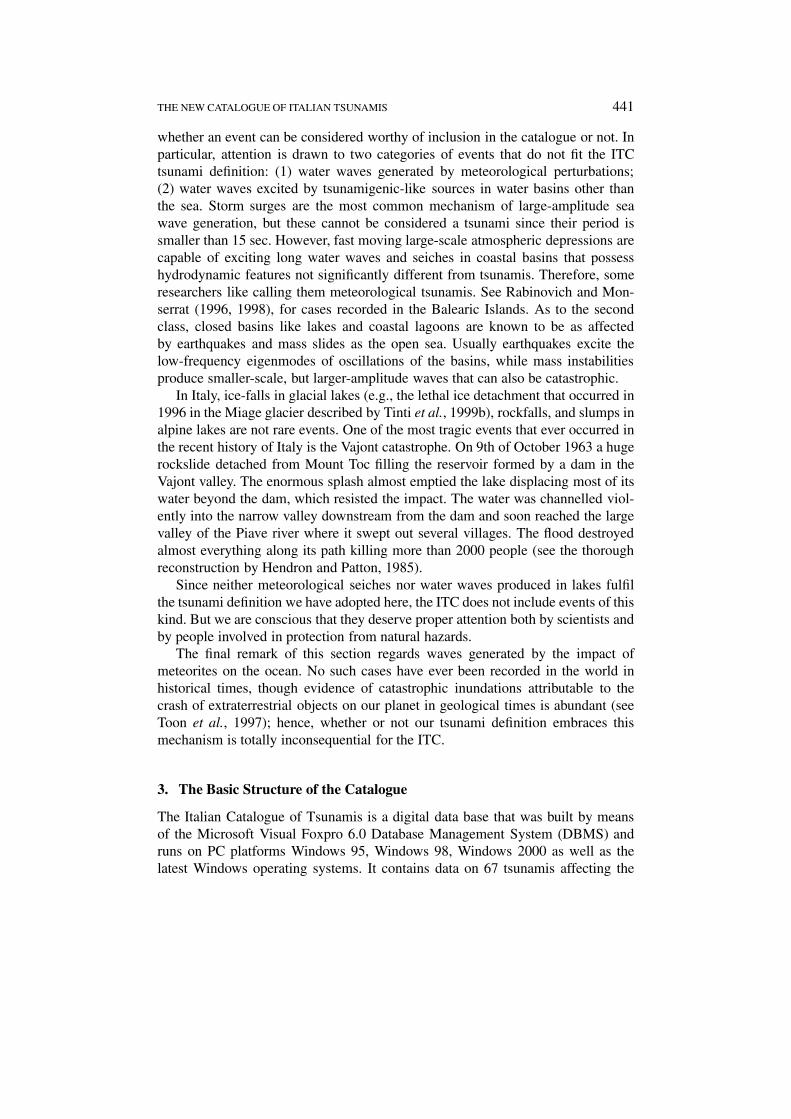
Figure 1. Main user interface of the Italian Tsunami Catalogue (ITC). The Main Screen (MS)displays event 66 of the database which corresponds to a tsunami that occurred in 1990 in east-ern Sicily, that was observed at Augusta and was caused by an intensity VIII and magnitude5.4 earthquake.
Italian seas, the first of which is the tsunami that was generated by the large Plinianeruption of Vesuvius. This eruption destroyed Pompei and other Roman villages in79 AD; it was recounted by the Roman writer Plinius Junior, whose description isthe first historical account of a natural catastrophe made with a scientific approach.The complete list of the events is given in the Appendix A.
The main user interface of ITC is the Main Screen (MS) depicted in Figure 1.As may be seen, it is formed by six informative boxes providing data on a selectedevent, and by a number of functional buttons, by means of which the user canperform operations on the database, and have access to ancillary tables and datasets. The example given in Figure 1 concerns a tsunami that occurred in 1990 inassociation with an I = 8.0 (MCS scale) earthquake that occurred in eastern Sicilyclose to the town of Augusta. The box in the upper left corner of the MS suppliesthe event identification code (66), which is a number used by the database softwareto point to the entry, as well as the event reliability (4), that is an important para-meter on which details will be given later. Information on the date and place of thetsunami occurrence, the generating mechanism, and the tsunami size (maximumrun-up observed in cm, tsunami intensity and tsunami magnitude) are providedin other specific boxes that are entitled respectively “Date information”, “Regioninformation”, “Source information” and “Tsunami information”.

THE NEW CATALOGUE OF ITALIAN TSUNAMIS 443
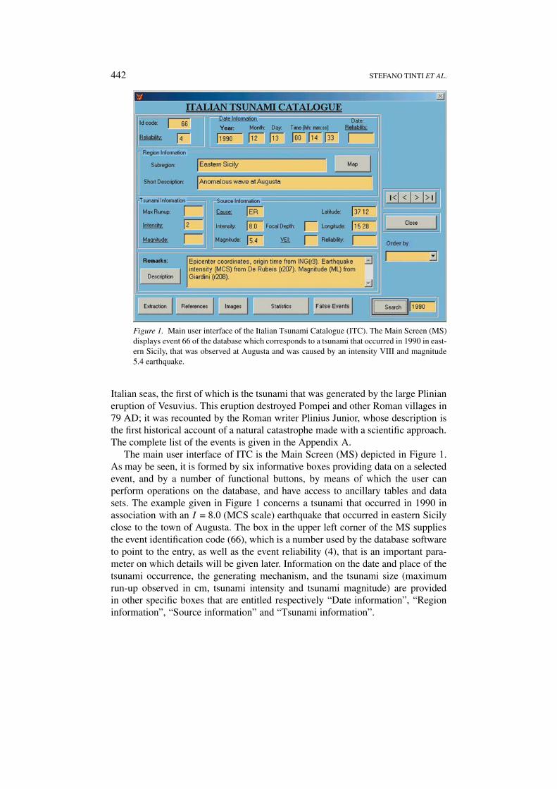
An on-line help facility can be utilised by the user to get more details on theparametric scheme adopted in the catalogue. For example, after clicking on thebutton called “Map”, the user obtains the map of the 15 sub-regions into which theItalian coasts have been subdivided within ITC, displayed in Figure 2. Notice thatLiguria (Italy) and Côte d’Azur (France) are considered as a unique tsunamigenicsub-region since usually tsunamis generated in the Ligurian sea affect the coastsof both areas. Notice also that the Sardinia coasts are not taken into account, sinceno event is known to have been generated there. A further example of what can beobtained through the on-line help is the screen reproduced in Figure 3, obtained byclicking on the underlined word “Cause” in the “Source information” box. It ex-plains the code used in ITC to specify the generating cause of the tsunami. Observethat there are different codes for tsunamigenic mass failures, distinguishing caseswhere sliding is due to pure gravitational instability from cases where the ruptureis triggered by earthquakes or by volcanic eruptions.
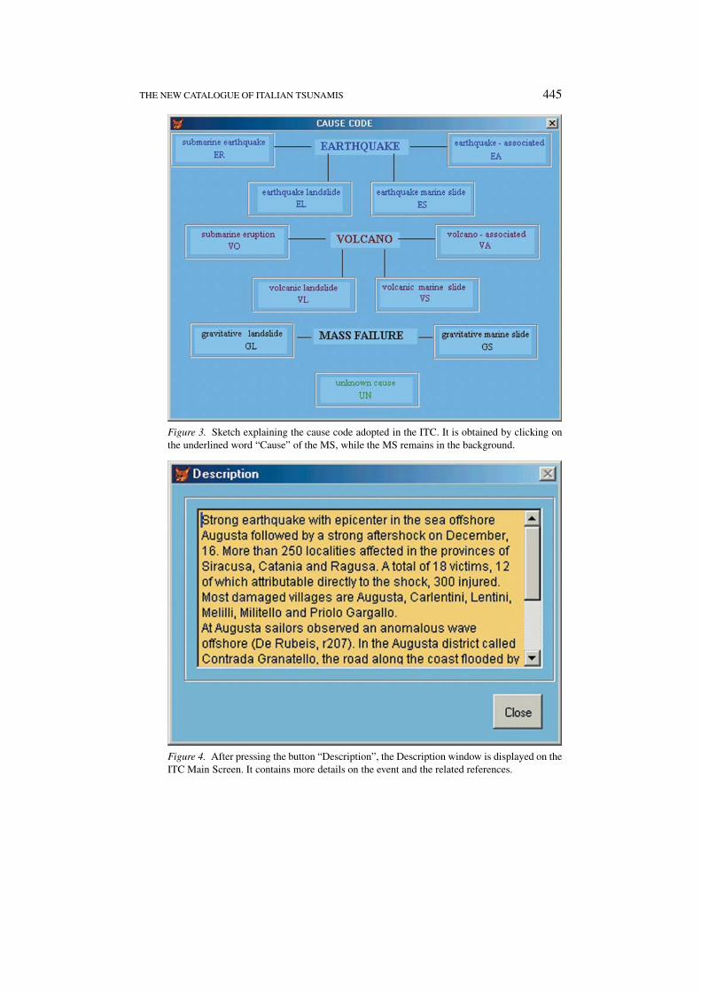
A short summary displayed in the MS provides an essential description ofthe phenomenon, but additional details can be obtained through the “Description”button located in the bottom box of the MS. Figure 4 shows the Description win-dow that opens after clicking this button. The user finds here an account of thecausal event and everything that is known about the tsunami, together with all thereferences available for the case. References are provided by means of the nameof the author (or of the first of the authors) followed by rxxx where xxx is thenumeric code identifying the work in the ancillary References Database (RD). Inthis example, the user learns that the main reference to the 1990 Augusta tsunamiis found in the work by De Rubeis et al. with code r207 (see Figure 4). Then hecan access the RD by means of the functional button called “References” on thebottom line of the MS (see Figure 1) and query the database by making use eitherof the above reference code or of the author name, to discover that De Rubeis etal.’s work (1991) is a contribution contained in a special Internal Report of the ING(today INGV) published soon after the earthquake.
Other functions can also be activated. For example, the “Extraction” buttonallows the user to select a list of events by using various extraction keys or combin-ation of keys (year, sub-region, cause, reliability, intensity). In addition, through thecommand found on the right side of the MS, the user can order the entries by year,identification code, sub-region or cause code, and then browse the database backand forth by pressing the left- and right-arrow keys. Moreover, the box “Search” inthe lower right corner of the MS helps one find a given event in the ITC by enteringits year of occurrence in the data entry window; in response the system will sortthe entries in chronological order and point to the first event of the specified year.The user can then advance to the following events by pressing the right-arrow key.Providing all the details on how to use the catalogue goes beyond the scope of thispaper, and it is believed that the account given here suffices to help the reader graspthe main concept, structure and facilities of this tool.

444 STEFANO TINTI ET AL.
Figure 2. Map showing the location of the 15 ITC sub-regions. It is displayed after the ITCuser presses the button “Map” on the MS.
4. Tsunami Size
Estimating the size of a complex phenomenon like a tsunami or an earthquake bymeans of a parametric scale is difficult and maybe even debatable. It is nonethelessa recognised need and a common practice, and size parameters are consideredby most people to be the most relevant parameters to search for in catalogues ofnatural events. The ITC uses intensity and magnitude to quantify a tsunamigenicearthquake and uses the explosivity index VEI (Simkin et al., 1981) to quantify avolcanic eruption. With regard to tsunamis, the 6-degree intensity scale by Siebergand Ambraseys (Ambraseys, 1962) is used to quantify the effects of a tsunami oncoasts and structures. An intensity = 1 tsunami is very light and only visible on
THE NEW CATALOGUE OF ITALIAN TSUNAMIS 445
Figure 3. Sketch explaining the cause code adopted in the ITC. It is obtained by clicking onthe underlined word “Cause” of the MS, while the MS remains in the background.
Figure 4. After pressing the button “Description”, the Description window is displayed on theITC Main Screen. It contains more details on the event and the related references.
446 STEFANO TINTI ET AL.
tide gauge records, while at the top of the scale an intensity = 6 tsunami is capableof causing large disasters with total destruction of man-made structures, extensiveflooding, many casualties, etc.
The magnitude is a parameter not frequently used in tsunami catalogues. In away analogous to the earthquake magnitude, the magnitude of a tsunami conveysinformation about the strength of the source rather than the effects of the waves.Murty and Loomis (1980) introduced a magnitude scale suitable for tsunamis pro-duced by earthquakes based on the initial potential energy of a tsunami EP . Theirformula is simple:
Tsunami Magnitude = 2 (Log EP − 19)
where EP is given in erg and may be calculated by means of the expression:
EP = 1
2
∫ρgh2ds.
Here the integral is extended over the whole tsunami source area, ds is the infin-itesimal area element, ρ is the water density and h is the vertical displacement ofthe ocean surface from the still level. Their idea is that the sudden dislocation ofthe sea floor has the effect of vertically displacing the sea water, and consequently,the ocean gains potential energy. At the end of the quake, the sea water is outof equilibrium and the potential energy gained is available for the propagationof tsunami waves. This point of view is justified by numerous hydraulic experi-ments (see the fundamental work by Hammack, 1973) and is commonly adoptedby tsunami modellers, who are accustomed to taking a water wave profile similarto the sea floor dislocation and a null initial velocity as initial conditions for theirnumerical simulations (e.g., Tinti et al., 1995). This concept cannot be applied tothe generating mechanism other than for submarine earthquakes, and therefore notsunami magnitude has yet been suggested for waves generated by landslides orpyroclastic flows.
In the ITC, the Murty and Loomis expression has been adopted and computedfor those tsunamis for which studies aimed at identifying the parent fault and therelated seismic focal parameters are available in the literature. The procedure is asfollows: once the fault is given, the solid earth surface displacement hE is calculatedthrough the classical Okada’s model, under the hypothesis of a homogeneous Earthwith a flat surface and of a rectangular uniform-slip fault (see Okada, 1992), thenthe sea surface displacement h is posed equal to hE in the submarine portion of thesource, and integrated according to the equation given previously. The magnitudevalues obtained in this manner are displayed in Table I. It is worth noting that theconstant 19 appearing in the formula was chosen by Murty and Loomis in sucha way as to get similar values for both the tsunami magnitude and the magnitudeof the associated earthquake. It was calibrated for the large events in the PacificOcean with MW about 8 or higher, and leads to very discrepant values for smaller

THE NEW CATALOGUE OF ITALIAN TSUNAMIS 447
Tabl
eI.
Tsu
nam
imag
nitu
deta
ble.
Tsu
nam
imag
nitu
des
have
been
com
pute
don
lyfo
rthe
5ca
ses
list
edin
this
tabl
e,fo
rw
hich
the
need
edfo
calp
aram
eter
sof
the
pare
ntea
rthq
uake
sco
uld
bees
tim
ated
.Fau
ltda
taar
ein
acco
rdan
cew
ith
tsun
amin
umer
ical
sim
ulat
ions
perf
orm
edby
Tin
tian
dP
iata
nesi
(199
6),T
inti
etal
.(20
01),
Tin
tian
dG
avag
ni(1
995)
.Pia
tane
sian
dT
inti
(200
2),a
ndT
inti
and
Arm
igli
ato
(200
0)fo
rth
eca
ses
resp
ectiv
ely
list
edin
row
s1
to5
ofth
eta
ble
Eve
ntsu
breg
ion:
Dat
eL
on∗
Lat
∗D
epth
Len
gth
Wid
thS
trik
eD
ipR
ake
Sli
pE
pM
L
(m)
(km
)(k
m)
(◦)
(◦)
(◦)
(m)
(erg
)
Gar
gano
:30
Jul1
627
15.2
541
.88
100
3520
090
270
1.3
2.12
×10
18−1
.4
Eas
tern
Sic
ily:
11Ja
n16
9315
.33
37.0
720
0050
1516
6.5
9090
6.2
1.41
×10
20+2
.3
Tyrr
h.C
alab
ria:
5F
eb17
8315
.92
38.2
010
050
3523
360
270
1.0
1.29
×10
18−1
.8
Tyrr
h.C
alab
ria:
8S
ep19
0516
.01
38.7
310
030
2024
580
270
2.5
1.61
×10
19+0
.4
Mes
sina
Str
aits
:28
Dec
1908
15.5
338
.07
4000
4518
11.5
2927
01.
426.
06×
1018
−0.4
∗ Co-
ordi
nate
sof
the
mid
poin
tof
the
uppe
rbo
rder
ofth
eas
sum
edfa
ult.

448 STEFANO TINTI ET AL.
Table IIa. Reliability scale of the Italian Tsunami catalogue
Reliability Description Cause Tsunami Sources
4 Definite Tsunami × × ×3 Probable Tsunami × × /
2 Questionable Tsunami × / ×/ × ×� × ×
1 Improbable Tsunami × / /
/ × /
� × /
0 Very Improbable Tsunami / / ×/ / /
� / ×no No Tsunami All other combinations
earthquake sources which are the rule for Italy. Therefore, it is not surprising thatthe tsunami magnitudes in Table I are so small.
5. Tsunami Reliability
Reliability of the entries in the ITC were been graded according to the 5-degreemodified Iida scale that was introduced by Tinti and Maramai (1996) in the TMC,and ranges from degree 0, equivalent to a “very improbable tsunami”, to degree 4corresponding to a “definite tsunami”. The reliability is a very important parameterwhich helps the catalogue user judge the quality of the data. Unfortunately, it wasonly recently introduced into tsunami catalogues and was sporadically used in thepast. There is no doubt that it is inevitably the result of the judgement of the expertsassembling the database and is therefore intrinsically subjective, but subjectivenesscan be tempered if some criteria are defined and coherently applied to the data.
The approach for determining reliability that was outlined in the TMC wasbetter defined for the ITC. It consists of taking into account and rating separatelydifferent elements or categories of the data, namely: (1) what is known about thetsunami cause, (2) what is known about the tsunami itself, and (3) what is knownabout the documentary sources. Each category is rated on three levels, and thenthe final reliability is obtained by combining these partial scores according to thescheme given in Table IIa.
Table IIb clarifies the basis for the reliability score attribution, but deservessome comments, especially with regard to the columns “Tsunami” and “Sources”.Considering the former, we point out that not all of the descriptions of anom-alous behaviour of the sea following a potentially tsunamigenic event (namely

THE NEW CATALOGUE OF ITALIAN TSUNAMIS 449
Table IIb. Meaning of the symbols
Symbol Cause Tsunami Sources
� No information No specific information Very Posterior
/ Scarce/uncertain information Scarce/uncertain specific information Posterior
× Good information Good Specific information Coeval
earthquake, volcanic eruption or landslide) can be considered as descriptions oftsunamis. For example, accounts of sea agitation, or of seamen feeling their boatshit from below by anomalous shocks, concern phenomena that are not peculiar toa tsunami, and hence cannot be taken as proof of a tsunami occurrence. For thispurpose, at least some specific characteristics of a tsunami have to be reported,such as observations of long-period waves and oscillations, of large sea retreat orflooding, etc. In view of this, if no data can be found that are specific to a tsunamifrom the available sources, the attributed rate is “�”. On the other hand, if suchdata exist, then the rate is “/” or “×” depending on their quality and clarity. Withregard to the documentary sources, emphasis is put on the delay between the eventoccurrence and the date of the source; considering that time elapsing may corruptand confuse memories, reliability is taken to decrease with increasing delay. Hence,the score is given on the basis of the time interval separating the event and theoldest available source. If the event and the source are coeval, the score is “×”; ifthe source is very subsequent, which means that the author or authors lived severalgenerations later (i.e. several tens of years or centuries), the score is “�”; and foran intermediate delay, the score is “/”. Appendix B provides the list of all the eventsin the ITC with the partial rates attributed in the three categories and the resultingvalue of reliability.
6. Tsunami Images
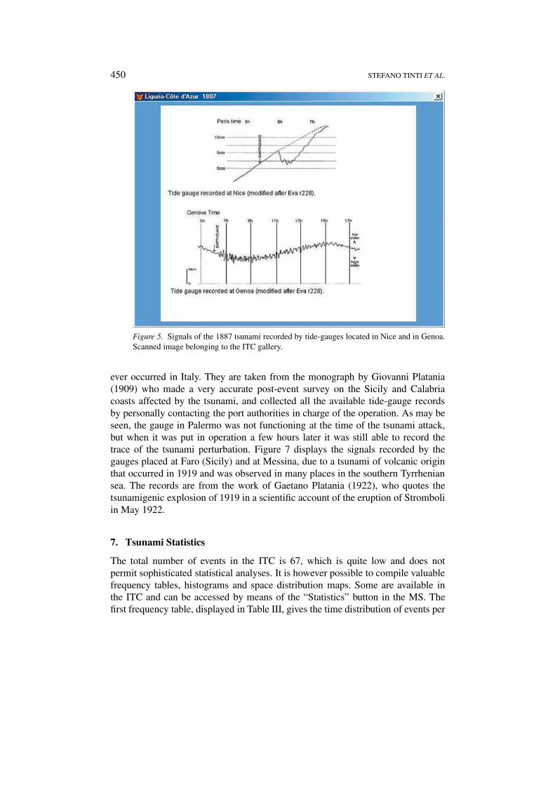
The ITC contains a small gallery of images that can be accessed by means of the“Images” button placed in the bottom string of the MS (see Figure 1). These fig-ures have been gathered from the literature and the documentary sources, scannedand later refined in order to improve their quality. They are pictures documentingdamage produced by tsunamis, or records of analogue tide-gauges. A sample ofthese can be seen in Figures 5–7. Figure 5 displays mareograms of the tsunamithat occurred in 1887 in the Liguria-Côte d’Azur region recorded by gauges inthe ports of Nice and of Genoa. They are also reproduced in a recent study byEva and Rabinovich (1997) who performed numerical simulations of the tsunamiand spectral analysis of the experimental records. Figure 6 reproduces the gaugerecords of the ports of Palermo, Napoli and Civitavecchia capturing the tsunamiof the 28 December 1908, which is one of the most destructive tsunamis that
450 STEFANO TINTI ET AL.
Figure 5. Signals of the 1887 tsunami recorded by tide-gauges located in Nice and in Genoa.Scanned image belonging to the ITC gallery.
ever occurred in Italy. They are taken from the monograph by Giovanni Platania(1909) who made a very accurate post-event survey on the Sicily and Calabriacoasts affected by the tsunami, and collected all the available tide-gauge recordsby personally contacting the port authorities in charge of the operation. As may beseen, the gauge in Palermo was not functioning at the time of the tsunami attack,but when it was put in operation a few hours later it was still able to record thetrace of the tsunami perturbation. Figure 7 displays the signals recorded by thegauges placed at Faro (Sicily) and at Messina, due to a tsunami of volcanic originthat occurred in 1919 and was observed in many places in the southern Tyrrheniansea. The records are from the work of Gaetano Platania (1922), who quotes thetsunamigenic explosion of 1919 in a scientific account of the eruption of Stromboliin May 1922.
7. Tsunami Statistics
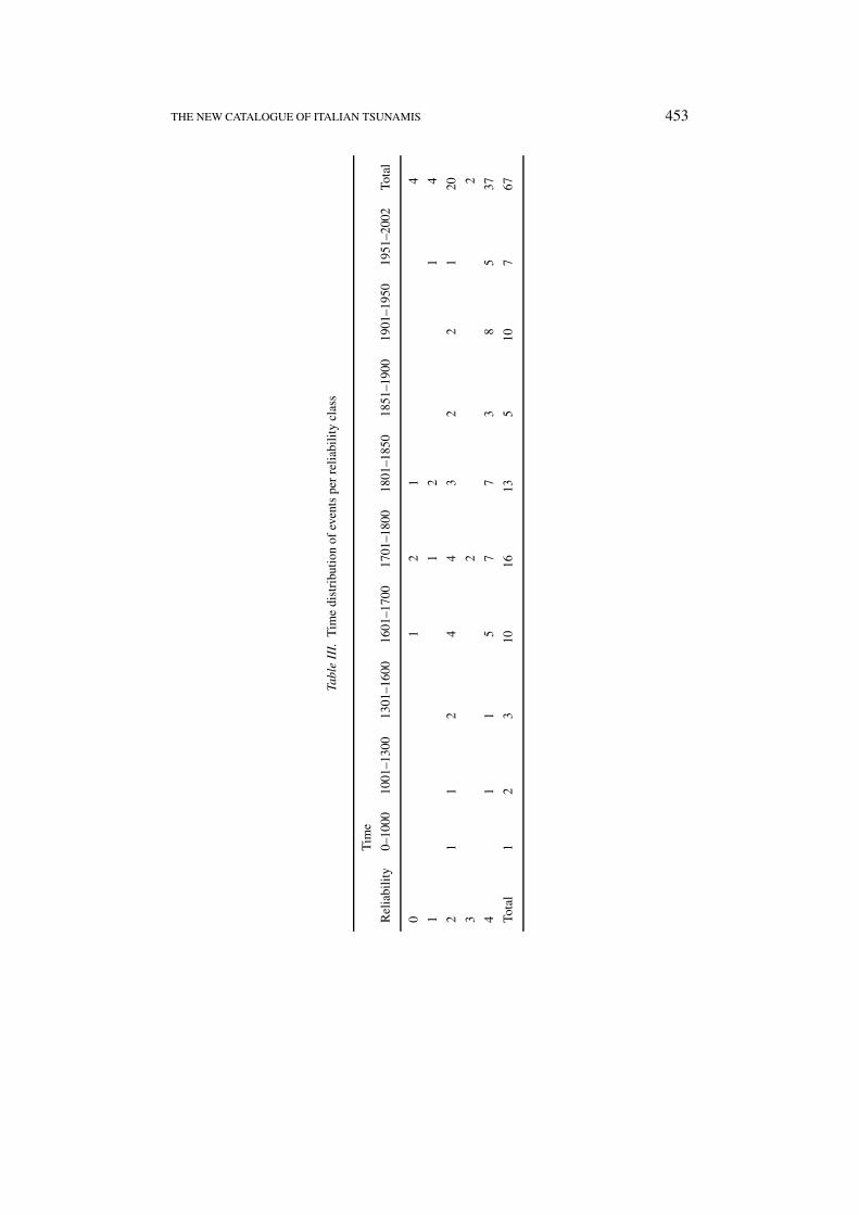
The total number of events in the ITC is 67, which is quite low and does notpermit sophisticated statistical analyses. It is however possible to compile valuablefrequency tables, histograms and space distribution maps. Some are available inthe ITC and can be accessed by means of the “Statistics” button in the MS. Thefirst frequency table, displayed in Table III, gives the time distribution of events per

THE NEW CATALOGUE OF ITALIAN TSUNAMIS 451
Figure 6. Scanned image of 3 tide-gauge records of the 1908 Messina Straits tsunami. Thisimage is displayed by selecting the item “Mareograms 2” from the 5-item menu on the top ofthe screen.
Figure 7. Picture of the record of the 1919 tsunami taken at Messina. The user can obtain thisimage by selecting the item “Mareogram 2” from the 2-item menu on the top of the screen.

452 STEFANO TINTI ET AL.
Figure 8. Space distribution of the events of the catalogue: circles indicate the place of occur-rence. When more events occurred in the same place, the numbers beside circles indicate thetotal amount of events.
reliability classes. The last column of this table shows the frequencies of reliabilityand indicates that most entries in the catalogue are definite or probable tsunamis,having been attributed reliability values of 4 (37 events) or 3 (two events). Thisproperty is common to all columns on the right side of the table, correspondingto the last three centuries, which is an obvious effect of data tending to be moreabundant and less equivocal as time advances and science progresses. The timedistribution is rather unequal. Only three entries are found prior to 1300 and onlysix prior to 1600. But in later times, the total number of entries per century is ratherstable (on average 15). This certainly means that ITC is far from complete until the16th century, and gives some hints on the possible completeness of the cataloguein the following times.
THE NEW CATALOGUE OF ITALIAN TSUNAMIS 453
Tabl
eII
I.T
ime
dist
ribu
tion
ofev
ents
per
reli
abil
ity
clas
s
Tim
e
Rel
iabi
lity
0–10
0010
01–1
300
1301
–160
016
01–1
700
1701
–180
018
01–1
850
1851
–190
019
01–1
950
1951
–200
2To
tal
01
21
4
11
21
4
21
12
44
32
21
20
32
2
41
15
77
38
537
Tota
l1
23
1016
135
107
67
454 STEFANO TINTI ET AL.
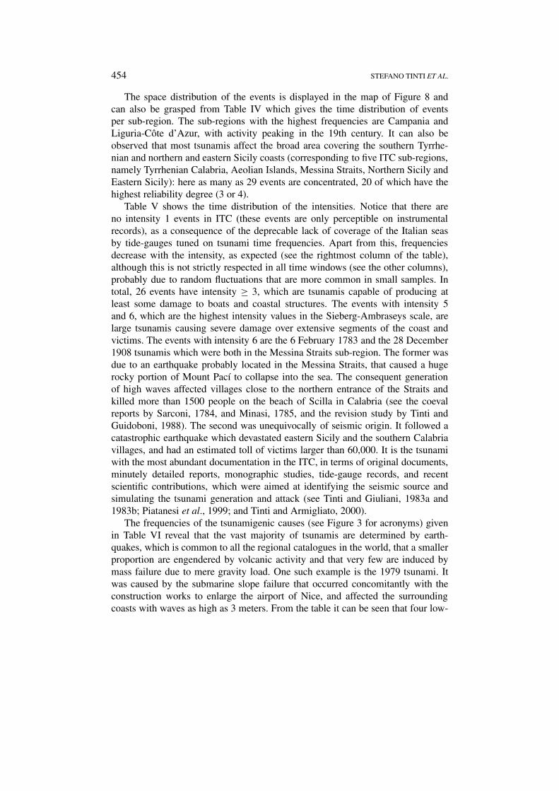
The space distribution of the events is displayed in the map of Figure 8 andcan also be grasped from Table IV which gives the time distribution of eventsper sub-region. The sub-regions with the highest frequencies are Campania andLiguria-Côte d’Azur, with activity peaking in the 19th century. It can also beobserved that most tsunamis affect the broad area covering the southern Tyrrhe-nian and northern and eastern Sicily coasts (corresponding to five ITC sub-regions,namely Tyrrhenian Calabria, Aeolian Islands, Messina Straits, Northern Sicily andEastern Sicily): here as many as 29 events are concentrated, 20 of which have thehighest reliability degree (3 or 4).
Table V shows the time distribution of the intensities. Notice that there areno intensity 1 events in ITC (these events are only perceptible on instrumentalrecords), as a consequence of the deprecable lack of coverage of the Italian seasby tide-gauges tuned on tsunami time frequencies. Apart from this, frequenciesdecrease with the intensity, as expected (see the rightmost column of the table),although this is not strictly respected in all time windows (see the other columns),probably due to random fluctuations that are more common in small samples. Intotal, 26 events have intensity ≥ 3, which are tsunamis capable of producing atleast some damage to boats and coastal structures. The events with intensity 5and 6, which are the highest intensity values in the Sieberg-Ambraseys scale, arelarge tsunamis causing severe damage over extensive segments of the coast andvictims. The events with intensity 6 are the 6 February 1783 and the 28 December1908 tsunamis which were both in the Messina Straits sub-region. The former wasdue to an earthquake probably located in the Messina Straits, that caused a hugerocky portion of Mount Pací to collapse into the sea. The consequent generationof high waves affected villages close to the northern entrance of the Straits andkilled more than 1500 people on the beach of Scilla in Calabria (see the coevalreports by Sarconi, 1784, and Minasi, 1785, and the revision study by Tinti andGuidoboni, 1988). The second was unequivocally of seismic origin. It followed acatastrophic earthquake which devastated eastern Sicily and the southern Calabriavillages, and had an estimated toll of victims larger than 60,000. It is the tsunamiwith the most abundant documentation in the ITC, in terms of original documents,minutely detailed reports, monographic studies, tide-gauge records, and recentscientific contributions, which were aimed at identifying the seismic source andsimulating the tsunami generation and attack (see Tinti and Giuliani, 1983a and1983b; Piatanesi et al., 1999; and Tinti and Armigliato, 2000).
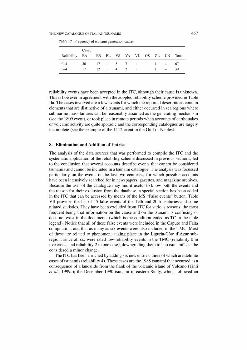
The frequencies of the tsunamigenic causes (see Figure 3 for acronyms) givenin Table VI reveal that the vast majority of tsunamis are determined by earth-quakes, which is common to all the regional catalogues in the world, that a smallerproportion are engendered by volcanic activity and that very few are induced bymass failure due to mere gravity load. One such example is the 1979 tsunami. Itwas caused by the submarine slope failure that occurred concomitantly with theconstruction works to enlarge the airport of Nice, and affected the surroundingcoasts with waves as high as 3 meters. From the table it can be seen that four low-

THE NEW CATALOGUE OF ITALIAN TSUNAMIS 455
Tabl
eIV
.T
ime
dist
ribu
tion
ofev
ents
per
sub-
regi
on
Tim
e
Sub
-reg
ions
0–10
0010
01–1
300
1301
–160
016
01–1
700
1701
–180
018
01–1
850
1851
–190
019
01–1
950
1951
–200
2To
tal
Nor
thA
dria
tic
11
Cen
tral
Adr
iati
c1
11
3
Gar
gano
11
13
Apu
lia
11
Ioni
anC
alab
ria
12
14
Eas
tern
Sic
ily
11
21
16
Sic
ily
Cha
nnel
11
2
Nor
ther
nS
icil
y1
11
14
Mes
sina
Str
aits
12
14
Aeo
lian
Isla
nds
53
8
Tyrr
heni
anC
alab
ria
14
11
7
Cam
pani
a1
12
23
110
Lat
ium
11
Tus
cany
11
13
Lig
uria
-Côt
ed’
Azu
r1
14
22
10
Tota
l1
23
1016
135
107
67

456 STEFANO TINTI ET AL.
Tabl
eV.
Tim
edi
stri
buti
onof
even
tspe
rin
tens
ity
clas
s.T
here
are
66as
sign
edin
tens
itie
sin
stea
dof
67,
sinc
eno
inte
nsit
yva
lue
coul
dha
vebe
enat
trib
uted
toth
e18
89G
arga
nots
unam
i,du
eto
the
lack
ofsp
ecifi
cde
tail
son
wav
eef
fect
son
the
coas
ts.
Thi
sev
ent
trea
ted
byB
arat
ta(1
901)
was
rece
ntly
revi
sed
byT
inti
etal
.(19
95)
Tim
e
Inte
nsit
y0–
1000
1001
–130
013
01–1
600
1601
–170
017
01–1
800
1801
–185
018
51–1
900
1901
–195
019
51–2
002
Tota
l
10
21
12
612
91
44
40
31
23
23
41
16
41
21
15
52
13
61
12
Tota
l1
23
1016
134
107
66
THE NEW CATALOGUE OF ITALIAN TSUNAMIS 457
Table VI. Frequency of tsunami generation causes
Cause
Reliability EA ER EL VS VA VL GS GL UN Total
0–4 30 17 1 5 7 1 1 1 4 67
3–4 17 12 1 4 2 1 1 1 – 39
reliability events have been accepted in the ITC, although their cause is unknown.This is however in agreement with the adopted reliability scheme provided in TableIIa. The cases involved are a few events for which the reported descriptions containelements that are distinctive of a tsunami, and either occurred in sea regions wheresubmarine mass failures can be reasonably assumed as the generating mechanism(see the 1809 event), or took place in remote periods when accounts of earthquakesor volcanic activity are quite sporadic and the corresponding catalogues are largelyincomplete (see the example of the 1112 event in the Gulf of Naples).
8. Elimination and Addition of Entries
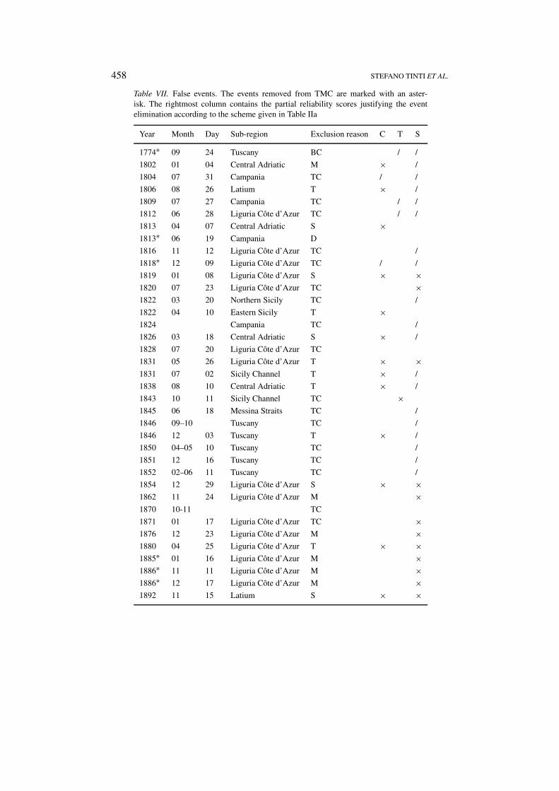
The analysis of the data sources that was performed to compile the ITC and thesystematic application of the reliability scheme discussed in previous sections, ledto the conclusion that several accounts describe events that cannot be consideredtsunamis and cannot be included in a tsunami catalogue. The analysis was focussedparticularly on the events of the last two centuries, for which possible accountshave been intensively searched for in newspapers, gazettes, and magazine archives.Because the user of the catalogue may find it useful to know both the events andthe reason for their exclusion from the database, a special section has been addedin the ITC that can be accessed by means of the MS “False events” button. TableVII provides the list of 45 false events of the 19th and 20th centuries and somerelated statistics. They have been excluded from ITC for various reasons, the mostfrequent being that information on the cause and on the tsunami is confusing ordoes not exist in the documents (which is the condition coded as TC in the tablelegend). Notice that all of these false events were included in the Caputo and Faitacompilation, and that as many as six events were also included in the TMC. Mostof these are related to phenomena taking place in the Liguria-Côte d’Azur sub-region: since all six were rated low-reliability events in the TMC (reliability 0 infive cases, and reliability 2 in one case), downgrading them to “no tsunami” can beconsidered a minor change.
The ITC has been enriched by adding six new entries, three of which are definitecases of tsunamis (reliability 4). These cases are the 1988 tsunami that occurred as aconsequence of a landslide from the flank of the volcanic island of Vulcano (Tintiet al., 1999c); the December 1990 tsunami in eastern Sicily, which followed an
458 STEFANO TINTI ET AL.
Table VII. False events. The events removed from TMC are marked with an aster-isk. The rightmost column contains the partial reliability scores justifying the eventelimination according to the scheme given in Table IIa
Year Month Day Sub-region Exclusion reason C T S
1774∗ 09 24 Tuscany BC / /
1802 01 04 Central Adriatic M × /
1804 07 31 Campania TC / /
1806 08 26 Latium T × /
1809 07 27 Campania TC / /
1812 06 28 Liguria Côte d’Azur TC / /
1813 04 07 Central Adriatic S ×1813∗ 06 19 Campania D
1816 11 12 Liguria Côte d’Azur TC /
1818∗ 12 09 Liguria Côte d’Azur TC / /
1819 01 08 Liguria Côte d’Azur S × ×1820 07 23 Liguria Côte d’Azur TC ×1822 03 20 Northern Sicily TC /
1822 04 10 Eastern Sicily T ×1824 Campania TC /
1826 03 18 Central Adriatic S × /
1828 07 20 Liguria Côte d’Azur TC
1831 05 26 Liguria Côte d’Azur T × ×1831 07 02 Sicily Channel T × /
1838 08 10 Central Adriatic T × /
1843 10 11 Sicily Channel TC ×1845 06 18 Messina Straits TC /
1846 09–10 Tuscany TC /
1846 12 03 Tuscany T × /
1850 04–05 10 Tuscany TC /
1851 12 16 Tuscany TC /
1852 02–06 11 Tuscany TC /
1854 12 29 Liguria Côte d’Azur S × ×1862 11 24 Liguria Côte d’Azur M ×1870 10-11 TC
1871 01 17 Liguria Côte d’Azur TC ×1876 12 23 Liguria Côte d’Azur M ×1880 04 25 Liguria Côte d’Azur T × ×1885∗ 01 16 Liguria Côte d’Azur M ×1886∗ 11 11 Liguria Côte d’Azur M ×1886∗ 12 17 Liguria Côte d’Azur M ×1892 11 15 Latium S × ×

THE NEW CATALOGUE OF ITALIAN TSUNAMIS 459
Table VII. Continued
Year Month Day Sub-region Exclusion reason C T S
1894 12 27 Aeolian Islands S × ×1895 11 01 Latium T × ×1896 10 16 Liguria Côte d’Azur S × ×1903 05 13 Northern Sicily TC × /
1914 01 15 Tuscany T × ×1919 10 22 Latium S × ×1939 01 27 Aeolian Islands S × ×1941 03 16 Northern Sicily T × ×
D = Duplication of another event. M = Waves due to a meteorological perturbation.T = No tsunami data. TC = Neither tsunami data nor indication of the possible cause.BC = No mention of tsunami effects on coheval sources and lack of knowledge on thepossible cause. S = Event with seismic origin for which no accounted evidence on theoccurrence of a tsunami can be found.
earthquake with an offshore source that affected more than 250 villages and killed18 people (see De Rubeis et al., 1991, and the MS screen displayed in Figure 1);and the 30 December 2002 tsunami occurred in Stromboli as the consequence ofa sequence of landslides in the Sciara del Fuoco subaerial and submarine flank,associated with an intense eruption period. This very recent tsunami caused largedestruction on the northern coast of Stromboli that was attacked by waves as highas 8-10 meters in several places, but killed no people since it occurred fortunatelyin winter season, i.e. in a season when the island is usually not populated by thetourists that are conversely so numerous in summertime. This tsunami has beenextensively studied (see e.g., Bonaccorso et al., 2003; Maramai et al., 2003; Tintiet al., 2003), and has shown the need for continuous monitoring of the stability ofthe north-east sector of the volcano and for the emplacement of a tsunami warningsystem to alert the population of Stromboli and of the neighbouring islands of thearchipelago.
9. Conclusions
The Italian Tsunami Catalogue improves and updates the previous tsunami cata-logue by Tinti and Maramai (1996). The data base spans a time interval of 2000years, but it is largely incomplete in the first millennium AD for which only oneevent (79 AD Vesuvius eruption tsunami) is included, attaining completeness pos-sibly only in the last three centuries. Most of the entries have a high level ofreliability (3–4), though the documentation is generally scarce and is abundantonly for a few cases (for example the Messina Straits tsunami of 1908). Tsunamisreported to have produced some damage (intensity 3 or larger) are the vast majority,but the known cases of severely damaging or catastrophic tsunamis (intensity 5

460 STEFANO TINTI ET AL.
and 6) are very few. The relatively modest proportion of tsunamis causing largeeffects on the coastlines can be easily explained by the fact that most Italian coastsremained deserted or almost uninhabited for a very long time. Since the level ofcoastal occupation and development has increased steadily in recent years in Italy,as in many other countries of the Mediterranean sea, vulnerability of coastal zoneshas also increased. Therefore the action of future tsunamis having the same mag-nitude as the past intermediate-intensity events can be expected to be much moredamaging. Southern Italy sub-regions emerge as the ones most prone to damagingtsunamis; in particular the areas embracing the Straits of Messina, including south-ern Tyrrhenian and eastern Sicily, are the most exposed, which is in agreement withprevious analyses. Earthquakes are the most frequent cause of Italian tsunamis, butcases related to volcanic activity of Stromboli, Vulcano and Vesuvius cannot beoverlooked. Tsunamigenic mass failures are infrequently reported, but they are po-tentially more capable of producing locally disastrous waves, and should thereforebe taken into serious account when envisaging scenarios of future disasters.
The ITC is a digital data base and can be downloaded freely in its present ver-sion from the INGV at the address http://www.ingv.it/italiantsunamis/tsun.html. Asoccurs for all catalogues, especially for those in digital form, it is under a process ofcontinuous maintenance, revision and updating. Our future work will mainly aimat (1) extending the catalogue time interval by including the results of research onpre-historical and on paleotsunamis that is being undertaken by several groups;(2) enriching the catalogue gallery by including more data on tsunami effects,records and simulations; (3) updating the reference data base by accounting fornew contributions of the scientific community; and (4) making attempts to reducecatalogue incompleteness prior to 1700.
Acknowledgments
The present paper is the result of a work that has been financed by the GNDT/INGV(Gruppo Nazionale per la Difesa dai Terremoti – Istituto Nazionale di Geofisica eVulcanologia). The authors wish to thank Dr.Alessio Piatanesi, INGV, who helpedcompute the tsunami magnitudes of the ITC.
Appendix A
List of the tsunamis of the Italian Tsunami Catalogue
Id Code Year Month/Day Sub-region Reliability Cause Tsu int Tsu mag1 79 8 24 Campania 2 VA 22 1112 6 20 Campania 2 UN 23 1169 2 4 Eastern Sicily 4 ER 44 1329 6 28 Eastern Sicily 2 VA 35 1511 3 26 North Adriatic 2 EA 26 1564 7 20 Liguria-Côte d’Azur 4 EA 27 1613 8 25 Northern Sicily 1 EA 2

THE NEW CATALOGUE OF ITALIAN TSUNAMIS 461
8 1627 7 30 Gargano 4 EA 5 −1.49 1631 12 17 Campania 4 VA 2
10 1638 3 27 Tyrrhenian Calabria 2 EA 211 1646 4 5 Tuscany 4 EA 312 1649 1 Messina Straits 1 EA 313 1672 4 14 Central Adriatic 4 ER 214 1693 1 9 Eastern Sicily 2 ER 215 1693 1 11 Eastern Sicily 4 ER 5 +2.316 1698 5 14 Campania 2 VA 217 1703 2 2 Latium 0 EA 218 1703 7 2 Liguria-Côte d’Azur 2 ER 219 1714 6 30 Campania 0 VA 220 1726 9 1 Northern Sicily 4 EA 221 1727 7 4 Sicily Channel 2 ER 222 1731 3 20 Gargano 4 EA 223 1742 1 19 Tuscany 4 ER 224 1743 2 20 Apulia 2 EA 225 1760 6 16 Campania 2 ER 226 1783 2 5 Tyrrhenian Calabria 4 EA 3 −1.827 1783 2 6 Messina Straits 4 EL 628 1783 2 7 Tyrrhenian Calabria 1 EA 229 1783 3 1 Tyrrhenian Calabria 3 EA 230 1783 3 28 Tyrrhenian Calabria 3 EA 231 1784 1 7 Ionian Calabria 4 ER 332 1784 1 19 Messina Straits 4 ER 333 1805 7 26 Campania 4 EA 234 1808 4 2 Liguria-Côte d’Azur 2 EA 235 1809 7 3 Liguria-Côte d’Azur 2 UN 236 1813 5 17 Campania 1 VA 237 1817 1 14 Sicily Channel 1 EA 238 1818 2 20 Eastern Sicily 4 EA 239 1818 2 23 Liguria-Côte d’Azur 2 EA 240 1823 3 5 Northern Sicily 4 ER 441 1828 10 9 Liguria-Côte d’Azur 4 EA 342 1832 3 8 Ionian Calabria 4 EA 343 1836 4 25 Ionian Calabria 4 EA 444 1846 8 14 Tuscany 4 EA 245 1847 8 26 Campania 0 UN 246 1875 3 17 Central Adriatic 4 ER 347 1887 2 23 Liguria-Côte d’Azur 4 ER 348 1888 7 30 Liguria-Côte d’Azur 2 EA 249 1889 12 8 Gargano 2 ER50 1894 11 16 Tyrrhenian Calabria 4 EA 351 1905 9 8 Tyrrhenian Calabria 4 EA 3 +0.452 1906 4 4 Campania 4 VA 253 1907 10 23 Ionian Calabria 4 EA 354 1908 12 28 Messina Straits 4 ER 6 −0.455 1916 7 3 Aeolian Islands 4 EA 256 1919 5 22 Aeolian Islands 4 EA 357 1926 8 17 Aeolian Islands 2 VO 258 1930 9 11 Aeolian Islands 4 VO 3

462 STEFANO TINTI ET AL.
59 1940 1 15 Northern Sicily 2 EA 260 1944 8 20 Aeolian Islands 4 VO 461 1954 2 Aeolian Islands 1 VO 262 1968 4 18 Liguria-Côte d’Azur 4 ER 263 1978 6 21 Central Adriatic 2 UN 464 1979 10 16 Liguria-Côte d’Azur 4 GS 365 1988 4 20 Aeolian Islands 4 GL 266 1990 12 13 Eastern Sicily 4 ER 267 2002 12 30 Aeolian Islands 4 VL 5
Appendix B
Partial Reliability scores (5th–7th column) and Reliability (8th column) of the ITC entries. Thereliability categories are denoted by C (cause), T (tsunami) and S (source): see text and Table IIbfor details.
Id code Year Month/Day C T S Reliability1 79 8 24 × / × 22 1112 6 20 × × 23 1169 2 4 × × × 44 1329 6 28 / × × 25 1511 3 26 / × × 26 1564 7 20 × × × 47 1613 8 25 × / / 18 1627 7 30 × × × 49 1631 12 17 × × × 4
10 1638 3 27 × / × 211 1646 4 5 × × × 412 1649 1 × / / 113 1672 4 14 × × × 414 1693 1 9 × / × 215 1693 1 11 × × × 416 1698 5 14 / × × 217 1703 2 2 / / / 018 1703 7 2 / × × 219 1714 6 30 / / × 020 1726 9 1 × × × 421 1727 7 4 × / × 222 1731 3 20 × × × 423 1742 1 19 × × × 424 1743 2 20 × / × 225 1760 6 16 × / × 226 1783 2 5 × × × 427 1783 2 6 × × × 428 1783 2 7 × / / 129 1783 3 1 × × / 330 1783 3 28 × × / 331 1784 1 7 × × × 432 1784 1 19 × × × 4

THE NEW CATALOGUE OF ITALIAN TSUNAMIS 463
33 1805 7 26 × × × 434 1808 4 2 / × × 235 1809 7 3 × × 236 1813 5 17 / × / 137 1817 1 14 / / × 138 1818 2 20 × × × 439 1818 2 23 / / × 240 1823 3 5 × × × 441 1828 10 9 × × × 442 1832 3 8 × × × 443 1836 4 25 × × × 444 1846 8 14 × × × 445 1847 8 26 / × 046 1875 3 17 × × × 447 1887 2 23 × × × 448 1888 7 30 / × × 249 1889 12 8 × / × 250 1894 11 16 × × × 451 1905 9 8 × × × 452 1906 4 4 × × × 453 1907 10 23 × × × 454 1908 12 28 × × × 455 1916 7 3 × × × 456 1919 5 22 × × × 457 1926 8 17 × / × 258 1930 9 11 × × × 459 1940 1 15 × / × 260 1944 8 20 × × × 461 1954 2 × / / 162 1968 4 18 × × × 463 1978 6 21 × × 264 1979 10 16 × × × 465 1988 4 20 × × × 466 1990 12 13 × × × 467 2002 12 30 × × × 4
References
Ambraseys, N. N.: 1962, Data for investigation of seismic sea waves in the Eastern Mediterranean,Bull. Seism. Soc. Am. 52, 895–913.
Antonopoulos, J.: 1990, Data for investigating tsunami activity in the Mediterranean Sea, Science ofTsunami Hazards 8, 39–52.
Baratta, M.: 1901, I terremoti d’Italia, F.lli Bocca, Torino, (in Italian).Bedosti, B. and Caputo, M.: 1986, Primo aggiornamento del catalogo dei maremoti delle coste
italiane, Atti Accademia Nazionale dei Lincei, Rendiconti Classe Scienze Fisiche, Matematiche,Naturali, Roma, Serie VIII, 80, 570–584 (in Italian).
Bonaccorso, A., Calvari, S., Garfí, G., Lodato, L., and Patane, D.: 2003, Dynamics of the December2002 flank failure and tsunami at Stromboli volcano inferred by volcanological and geophysicalobservations, Geophysical Research Letters 30(18), 1941, doi:10.1029/2003GL017702.

464 STEFANO TINTI ET AL.
Caputo, M. and Faita, G.: 1984, Primo catalogo dei maremoti delle coste italiane, Atti AccademiaNazionale dei Lincei, Memorie Classe Scienze Fisiche, Matematiche, Naturali, Roma, serie VIII,17, 213–356 (in Italian).
De Rubeis, V., Gasparini, C., Maramai, A., and Anzidei, M.: 1991, Il terremoto siciliano del 13/12/90,in E. Boschi and A. Basil (eds.), Contributi allo studio del terremoto della Sicilia orientale del13 dicembre del 1990, ING Pubbl. N.537 (in Italian).
Eva, C. and Rabinovich, A. B.: 1997, The February 23, 1887 tsunami recorded on the Ligurian coasts,western Mediterranean, Geophys. Res. Lett. 24, 2211–2214.
Galanopoulos, A. G.: 1960, Tsunamis observed on the coasts of Greece from antiquity to presenttime, Ann. Geofis. 13, 369–386.
GITEC-TWO (Genesis and Impact of Tsunamis on the European Coasts: Tsunami Warning andObservations): 1999, Final Scientific Report, University of Bologna.
Hammack, J. L.: 1973, A note on tsunamis: their generation and propagation in an ocean of uniformdepth, J. Fluid Mech. 60, 769–799.
Hendron, A. J. Jr. and Patton, F. D. L: 1985, The Vajont Slide: A Geotechnical Analysis Based on NewGeologic Observations of the Failure Surface, Technical Report GL-85-5, Vols. 1-2, US ArmyCorps of Engineers Waterways Experiment Station, Vickburgs, MS, pp. 104.
Maramai, A., Tinti, S., Graziani, L., Armigliato, A., Pagnoni, G., Manucci, A. and Zaniboni, F.: 2003,Quantitative observations of the physical effects of the Stromboli tsunami occurred on Decem-ber 30, 2002, EGS-AGU-EUG Joint Assembly, 06–11 April 2003, Nice, France, GeophysicalResearch Abstract, Vol. 5, CD-ROM Version.
Minasi, G.: 1785, Continuazione ed appendice sopra i tremuoti descritti nella relazione colla datadi Scilla de 30 settembre 1783, con altro che accadde in progresso, Messina (in Italian).
Murty, T. S. and Loomis, H. G.: 1980, A new objective tsunami magnitude scale, Marine Geodesy 4,267–282.
Okada, Y.: 1992, Internal deformation due to shear and tensile faults in a half-space, Bull. Seism.Soc. Am. 82, 1018–1040.
Piatanesi, A., Tinti, S., and Bortolucci, E.: 1999, Finite-element simulations of the 28 December1908 Messina Straits (southern Italy) tsunami, Phys. Chem. Earth 24, 145–150.
Piatanesi A. and Tinti S.: 2002, Numerical modeling of the September 8, 1905 Calabrian (SouthernItaly) tsunami, Geophys. Jour. Int. 150, 271–284.
Platania, Giovanni: 1909, Il maremoto dello Stretto di Messina del 28 dicembre 1908, Boll. Soc.Sism. Ital. 13, 369–458 (in Italian).
Platania, Gaetano: 1922, L’esplosione dello Stromboli del maggio 1922, Bollettino dell’AccademiaGioenia di Scienze Naturali, ser. II, 50, 2–17 (in Italian).
Rabinovich, A. B. and Monserrat, S.: 1996, Meteorological tsunamis near the Balearic and KurilIslands: descriptive and statistical analysis, Natural Hazards 13, 55–90.
Rabinovich, A. B. and Monserrat, S.: 1998, Generation of meteorological tsunamis (large amplitudeseiches) near the Balearic and Kuril Islands, Natural Hazards 14, 27–55.
Sarconi, M.: 1784, Istoria de’ fenomeni del tremuoto avvenuto nelle Calabrie e nel Valdemonenell’anno 1783 posta in luce dalla Reale Accademia delle Scienze e delle Belle Lettere di Napoli,Napoli (in Italian).
Simkin, T., Siebert, L., McClelland, L., Bridge, D., Newhall, Ch., and Latter, J. H.: 1981, Volca-noes of the World, Smithsonian Institution, Hutchinson Ross Publishing Company, Stroudsburg,Pennsylvania.
Soloviev, S. L.: 1990, Tsunamigenic zones in the Mediterranean Sea, Natural Hazards 3, 183–202.Soloviev, S. L., Solovieva O. N., Go C. N., Kim, K. S.. and Shchetnikov, N. A.: 2000, Tsunamis in
the Mediterranean Sea 2000 B.C.–2000 A.D., Kluwer Academic Publishers, Dordrecht, p. 237.Tinti, S.: 1993, The project GITEC: a European effort to address tsunami risk, in P. A. Merriman and
C. W. A. Browitt (eds.), Natural Disaster, Protecting Vulnerable Communities, Thomas Telford,London, pp. 147–155.

THE NEW CATALOGUE OF ITALIAN TSUNAMIS 465
Tinti, S. and Giuliani, D.: 1983a, The Messina Straits tsunami of the 28th December 1908: a criticalreview of the experimental data and observations, Il Nuovo Cimento 6C, 424–442.
Tinti, S. and Giuliani, D.: 1983b, The Messina Straits tsunami of the 28th December 1908: ananalytical model, Annales Geophys. 1, 463–468.
Tinti, S. and Guidoboni, E.: 1988, Revision of the tsunamis occurred in 1783 in Calabria and Sicily(Italy), Science of Tsunami Hazards 6, 17–22.
Tinti, S., Gavagni, I., and Piatanesi, A.: 1994, A finite-element numerical approach for modellingtsunamis, Annali di Geofisica 37, 1009–1026.
Tinti, S. and Gavagni, I.: 1995, A smoothing algorithm to enhance finite-element tsunami modeling:an application to the 5 February 1783 Calabrian case, Italy, Natural Hazards 12, 161–197.
Tinti, S., Maramai, A., and Favali, P.: 1995, The Gargano Promontory: an important seismogenic-tsunamigenic area, Marine Geology 122, 227–241.
Tinti, S. and Maramai, A.: 1996, Catalogue of tsunamis generated in Italy and in Côte d’Azur, France:a step towards a unified catalogue of tsunamis in Europe, Ann. Geofis. 39, 1253–1299 (ErrataCorrige, Ann. Geofis. 40, 781).
Tinti, S. and Piatanesi, A.: 1996, Numerical simulations of the tsunami induced by the 1627earthquake affecting Gargano, southern Italy, J. Geodynamics 21, 141–160.
Tinti, S., Baptista, M. A., Harbitz, C. B., and Maramai, A.: 1999a, The unified European catalogue oftsunamis: a GITEC experience, Proc. International Conference on Tsunamis, Paris, 26–28 May1998, pp. 84–99.
Tinti, S., Maramai, A., and Cerutti, A. V.: 1999b, The Miage glacier in the Valley of Aosta (westernAlps, Italy) and the extraordinary detachment occurred on August 9, 1996, Phys. Chem. Earth24, 157–161.
Tinti, S., Bortolucci, E., and Armigliato, A.: 1999c, Numerical simulation of the landslide-inducedtsunami of 1988 in Vulcano island, Italy, Bull. Volcanol. 61, 121–137.
Tinti, S. and Armigliato, A.: 2000, Tsunamigenic earthquakes, in Problems in Geophysics for theNew Millennium, Editrice Compositori, Bologna, pp. 27-46.
Tinti, S., Armigliato, A., and Bortolucci, E.: 2001, Contribution of tsunami data analysis to constrainthe seismic source: the case of the 1693 eastern Sicily earthquake, J. Seismology 5, 41–61.
Tinti, S., Pagnoni, G., Zaniboni, F., and Armigliato, A.: 2003, Simulations of the 30 December2002 Stromboli tsunami, Italy, EGS-AGU-EUG Joint Assembly, 06–11 April 2003, Nice, France,Geophysical Research Abstract, Vol. 5, CD-ROM Version.
Toon, O. B., Zahnle, K., Morrison, D., Turco, R. P., and Covey, C.: 1997, Environmental perturbationscaused by the impacts of asteroids and comets, Review of Geophysics 35, 41–78.
