the nevada traverse - nals nevada association of land … - 44.3.pdf · · 2017-08-27diamondback...
TRANSCRIPT

The Nevada TraverseJournal of the Professional Land Surveyors of Nevada
Institutional A ff i l iate National Society of Professional Surveyors • Member Western Federation of Professional Surveyors
Vol. 44, No.3 • September 2017
Boy Scouts of America - STEM Day Reno...Page 8
In Memory of Barbara Littell...Page 14


Alan W. Dill, PLS, PresidentStanley Consultants, Inc.4625 N. Buffalo Drive Las Vegas, NV 89129 Email: [email protected] Jerry D. Juarez, PLS, President-ElectManhard Consulting 9850 Double R Blvd., Ste. #101 Reno, NV 89521 Email: [email protected]
Halana D. Salazar, Secretary1746 Maple Creek LaneCarson City, NV 89701Email: [email protected]
Doug Wood, TreasurerDiamondback Land Surveying6140 Brent Thurman Way, Ste. 230Las Vegas, NV 89148Email: [email protected] Carl CdeBaca, PLS, Immediate Past PresidentP.O Box 1586Elko, NV 89803 Email: [email protected]
Carl C.de Baca, PLS, Editor, The Nevada TraverseP.O. Box 1586Elko, NV 89803Email: [email protected]
NALS Executive Office526 South E Street Santa Rosa, CA 95404 Email: [email protected]
Paul Burn, PLSG.C. Wallace, Inc.1555 South Rainbow Blvd.Las Vegas, NV 89146Email: [email protected]
Jeff Miller, Director – Southern NevadaWallace Morris Kline Surveying, LLC5740 S. Arville St., Ste. 206 Las Vegas, NV 89118Email: [email protected]
Jason Fackrell, Director – Southern Nevada5901 Shining Moon CourtLas Vegas, NV 89131Email: [email protected]
Greg Phillips, Director – Lahontan800 East College Pkwy.Carson City, NV 89706Email: [email protected]
Justin Moore, Director – LahontanOdyssey Engineering, Inc.895 Roberta Lane, #104Email: [email protected]
Christopher S. Konakis PLS, President and Chapter RepresentativeEmail:[email protected]
Norman Rockwell, PE, PLS, President-Elect
Jolene Hoffman, Secretary (acting)Email: [email protected]
William Nisbet, PLS, Treasurer
Justin Moore, [email protected]
Doug Larson, President-Elect [email protected]
Todd Enke, [email protected]
John Gomez, [email protected]
Jason Fackrell, [email protected]
Jeff Miller, [email protected]
Gene Sawyer, [email protected]
Russ Wonders, [email protected]
Nancy Almanzan, PLS City of Las Vegas333 N. Rancho Dr.Las Vegas, NV 89106Email: [email protected]
Matt Gingerich, PLS NVEnergyP.O. Box 10100 S4B2OReno, NV 89520Email: [email protected]
Who’s Who in NALS
WFPS Delegates from Nevada
Great Basin Chapter Officers
Lahontan Chapter Officers
Southern Nevada Chapter Officers
2016 State Association Officers Directors continued...
The Nevada Traverse
Executive Office
NSPS Director for Nevada
Directors

2 The Nevada Traverse Vol. 44, No. 3, 2017
This publication is issued quarterly by the Nevada Association of Land Surveyors (NALS) and is published as a service to the Land Surveying pro-fession of the state of Nevada. The Nevada Traverse is an open forum for all Surveyors, with an editorial policy predicated on the objective of NALS and Bylaws, Article II, which reads:
“The purpose of the association shall be to promote the common good and welfare of its members in their activities in the profession of Land Surveying; to promote the common good and welfare of the public in terms of professional land surveying activities; to promote and maintain the highest possible standards of professional ethics and practice; to promote public awareness and trust in Professional Land Surveyors and their work.
This organization, in its activities and in its membership, shall be non-partisan, non-sectarian, and non-discriminatory.”
The publication is mailed to NALS members and similar organizations on a com-plimentary basis. The Nevada Traverse is not copyright protected. Articles, except where specifically copyright noted, may be reprinted with proper credit. Written permission to reprint copyrighted material must be secured either from the author directly, or through the editor.
Articles appearing in the publication do not necessarily reflect the viewpoints of NALS, its officers, Board of Directors, or the editor, but are published as a service to its members, the general public, and for the betterment of the survey-ing profession. No responsibility is assumed for errors, misquotes, or deletions as to its contents.
Advertising Policy & Pricing(Effective September 1, 2016)
The Nevada Traverse is published quarterly by the Nevada Association of Land Surveyors and accepts advertising. Contact the editor for submittal specifications for advertisements. The rates per issue are as follows:
his edition of the Nevada Traverse is being assembled during the beginning of the dog days of summer. It’s miserably hot and inspiration is definitely taking a
back seat to perspiration. By the time you, dear reader, are looking at this, Sirius should be a bit closer to returning to the night sky which as we all know (really?) signifies the end of the dog days.
In this issue, Paul Pace wraps up his epic story of the French astronomer/surveyors attempting to refine their measurements of the shape of the earth in the 18th century. I hope you have enjoyed this story as much as I have. Recently graduated GBC Land Surveying Geomatics student
Deadlines for submittals are the middle of January, April, July, and October. Business cards of the members will be published in each issue unless otherwise requested.
Running an ad does not imply endorsement of that advertiser by NALS, and the editor reserves the right to not accept ads which may be in poor taste or objectionable to the policies of NALS.
Send ad requests to:The Nevada Traverse
PHONE 888.994.3510 • FAX 707.578.4406email: [email protected]
The Nevada Traverse
TheEditor’sCornerby Carl C. de Baca, PLS
Table Of ContentsThe Editor’s Corner . . . . . . . . . . . . . . . . . . . . . . . . . . .2About the Cover . . . . . . . . . . . . . . . . . . . . . . . . . . . . . .3The President’s Message . . . . . . . . . . . . . . . . . . . . . .4The Power of Ideas France’s Geodesic Mission to Peru 1735-1744, Part IV . . . . . . . . . . . . . . . . . . . . . . . . . . .5Boy Scouts of America - STEM Day Reno . . . . . . . . .8NSPS Team At National Jamboree, The Boy Scouts of America . . . . . . . . . . . . . . . . . . . . .8Merit Badge in Surveying . . . . . . . . . . . . . . . . . . . 9-12Letter to the Editor . . . . . . . . . . . . . . . . . . . . . . . . . . .13Chuck Cassano Rest in Peace . . . . . . . . . . . . . . . . .13Barbara Littell Rest in Peace . . . . . . . . . . . . . . . . . . .14Memories of Barbara Littell . . . . . . . . . . . . . . . . . . . .15Sustaining Members . . . . . . . . . . . . . . . . . . . . . . . . .19Professional Listings.. . . . . . . . . . . . . . . . . . . . . . . . .20NALS Adopts Code of Ethics . . . . . . . . . . . . . . . . . . .21NALS Family Night with the Aces . . . . . . . . . . . . . . .21Recruiting Future Land Surveyors . . . . . . . . . . . . . . .21NALS BoD Meeting Minutes . . . . . . . . . . . . . . . . . . .24WFPS Report . . . . . . . . . . . . . . . . . . . . . . . . . . . . . .28Lahontan Chapter Report . . . . . . . . . . . . . . . . . . . . .29Great Basin Chapter Report . . . . . . . . . . . . . . . . . . .29GBC Celebrates Scholarship, Integrity and Camaraderie . . . . . . . . . . . . . . . . . . . . . . . . . . . . . . .29Deuteronomy 27:17 Through the Ages . . . . . . . . . . .32Advertiser Index . . . . . . . . . . . . . . . . Inside Back Cover
T
CONTINUED ON NEXT PAGE u
MEMBER NON-MEMBER PRICE PRICE 1 Issue Yearly (4x) 1 Issue Yearly (4x)
Prof. Listing $70.00 $165.00 $265.00 $525.001/8 Page $100.00 $305.00 $295.00 $615.001/4 Page $175.00 $525.00 $345.00 $965.001/2 Pg (horiz or vert) $240.00 $730.00 $430.00 $1180.003/4 Page $315.00 $950.00 $505.00 $1310.00Full Page $350.00 $1045.00 $540.00 $1530.00
1/8 Page $200.00 $405.00 $395.00 $715.001/4 Page $290.00 $770.00 $485.00 $1340.001/2 Pg (horiz or vert) $400.00 $1080.00 $610.00 $1615.003/4 Page $580.00 $1740.00 $1000.00 $2442.00Full Page $610.00 $1745.00 $890.00 $2225.00
Inside Front Cover $810.00 $1945.00 $1090.00 $2425.00Inside Back Cover $290.00 $770.00 $485.00 $1340.00Outside Back Cover $400.00 $1080.00 $610.00 $1615.00
Web Link - Added toDigital Version $50.00 $100.00 $100.00 $200.00
Insertions - Tear Outs CALL FOR QUOTE
B&W
FULL
CO
LOR
SPEC
IAL
PLAC
EMEN
TEN
HAN
CEM
ENTS
SUSTAINING MEMBERSHIP $195 Annually
INCLUDES:• Complimentary business listing in the Traverse• Complimentary listing on NALS website• Member pricing on ads in the Nevada Traverse

The Nevada Traverse Vol. 4 No. 3, 2017 3
About the Cover...and NDOT employee Shane Trotter has generously shared his capstone project with us. It is a study on our dwindling numbers and offers a suggested path to recruitment. Some of you probably took part in one of Shane’s surveys during the last NALS conference. By the way, congratulations to Shane as well as to Jake Johnson of NV Energy and Mark Van Slyke of NDOT (Elko) for graduating with their BS in Surveying from our favorite program!We lost a great surveyor and fellow NALS member when Barbara Littell succumbed after a long battle with cancer earlier this year. She will be missed. And longtime Nevada surveyor Charles (Chuck) Cassano also lost a battle with cancer this summer. And in another sad turn of events, long time NALS member, former CLSA president Marc VanZuuk lost his battle with cancer and passed away right as this edition is going to print. Marc was a giant in California surveying and even if you didn’t know him, you probably saw his wry smile hiding behind that handlebar moustache at every joint NALS/CLSA conference in the past twenty years. Marc was a good friend of mine and he will be missed. May they Rest in Peace.
The Lahontan Chapter recently went to bat for one of their own, also fighting a battle against the big C. They applied on his behalf to the NSPS Foundation, Bonnie Atwell Memorial Fund and were able to secure some badly needed funds for their member in need. We should all be thankful that the NSPS Foundation exists and that they were able to assist. Having said that, the Atwell fund is not particularly well-off and we should all consider digging into our pockets and sending in a little something. The money in this fund is used exclusively for aiding surveyors in medical emergencies and no other use is permitted. Hopefully NALS, through its foundation will endeavor to undertake some fund-raising activities for the Atwell fund and its sister fund, the Disaster Relief Fund, which is used to help surveyors who have been the victims of fires, floods and other natural disasters.The Lahontan Chapter completed a youth outreach mission by participation in the Boy Scouts STEM day event in south Reno. During that event the volunteers were approached by a Scouting administrator who expressed interest in having NALS assist with the Surveying Merit Badge. NALS members Ryan Cook and Larry Grube are long time Surveying Merit Badge instructors and the two parties have been put in touch with each other.
The Lahontan Chapter President gives us a little insight into his Chapter’s 1st annual baseball outing at the Reno Aces Ballpark. The Aces are the Triple A affiliate of the Arizona Diamondbacks and at the time of this writing are in a death struggle for first place in their division.
The SNALS Golf Tournament will be held on October 21, 2018 at the Casablanca Resort Casino in Mesquite, NV. Be there or Be square. See you all in the Fall. U
The Editor’s Corner... continued from previous page
Barbara Littell surveying after a desert rain shower.Photo taken by Steve Parrish
Doug Larson of NVEnergy takes a Cub Scout through the paces
Electronic BLM ManualThe Manual of Surveying Instructions
2009Currently available on the BLM website:
http://www.blm.gov/pgdata/content/wo/en/prog/more/cadastralsurvey/2009_edition.html

4 The Nevada Traverse Vol. 44, No. 3, 2017
s we move towards the fall season there are several things happening in our Association. The Central Office, with the help of immediate Past President Carl C. de
Baca, has been working on some changes and necessary edits to our by-laws. Once these have been reviewed and approved they will be sent to the general membership for approval and your acceptance. We do have a strong need for volunteers on several committees. Our Legislative Committee needs volunteers to help with necessary changes to NRS 327, and NRS 625. Most of these changes are driven by a need to modernize language, prepare for the datum changes coming in 2022, and strengthen our areas of practice. We really need your help, and action on this front. I encourage you to consider helping on this very important effort. Currently certain individuals are doing too much of the work. As I have mentioned before, we need more involvement on our Advanced Technology and Advanced Education Committees. These are critical areas of concern over the next many years. I know there are some very talented, highly technical people out there that could be providing great help, advice, and contributions to the important functions of these committees. Please volunteer to help shape the future and next generation of Surveyors. We need more energy, more involvement, and more active leaders in all these areas. Come give it a try. You might find it rewarding and you can make a difference. Involvement will bring many benefits. You will meet your peers throughout the State, have a better understanding of their challenges and outlook on the profession, gaining a much better overall standing in the profession. We are currently on solid ground financially due to the success of the conference, the work of the Central Office, and your continued membership. This is a very positive change from several years ago. Thank You to all our members, sponsors, and sustaining members for your continued support and contributions.
And now a little reflection, and a story intended to help influence those up and coming professionals to get more involved. When I look back on what now is a forty year career and really think about the changes that have taken place it is simply amazing. My first experience on a field crew started in 1978. I was a member of a three man crew (chainman). We did a variety of construction, boundary and topo surveys, and we preformed many layouts for burial plots. This crew worked exclusively for Forrest Lawn Mortuaries in the Architectural and Engineering office. We used stadia for volume topo, all measurements were made with a steel tape and plumb bob, we had a T-16 theodolite, and an EDM was a luxury this group could not afford. We slope-chained, used spring balances, and actually made temperature corrections when necessary. We had to use a pay phone to call the office. We knew where all the celebrities were buried. The Party Chief was a Biker from Wisconsin who carried a forty-five caliber handgun in his lunch box, rode his Harley daily, and his favorite part of the day was listening to “Paul Harvey” at
lunch time. The head chainman was a fifty-year old vegetarian with eight children who could swing a twenty pound sledge like no other. His highlight during the week was a Veggie Burger at a local shop once a week. I was an eighteen year old kid who was taking classes in the Associate Program at Pasadena Community College in Surveying Photogrammetry, and looked forward to just about everything including “Paul Harvey” and the Veggie Burgers. I thought I knew something, but they showed me just how much I didn’t know. They taught me a ton and I will never forget them. One day I grew tired of writing “cut six feet” on the lath, and moved on to the City of Los Angeles where I worked for Water and Power as a Field Engineering Aide on mostly remote out-of-town projects. We worked on five-hundred-mile transmission lines for design and eventual construction. We had EDM’s, T-2’s, and helicopters. It was an absolutely amazing experience. We had no GPS, we needed line of sight, and we became like family. Eventually marriage and my own family lead me into the private engineering world and Professional Licensing in Nevada, where the learning has never stopped. Many lifelong friendships have developed.
The point of all this is to help illustrate just how easy it was then to get young people excited about what we do, and just what fun it could and can be. We had the time, we had the system, the opportunities, and we needed a quarter of the actual work load to provide forty hour weeks. I, and many others were lucky to come through the system when we did. You had to learn the basic calculation methods, learn basic measuring techniques, and through doing so gained an understanding of what they were for. With the technology, today we teach what button to push, what battery to charge, and what data to transfer. There is no time (at least we don’t take it) to teach the basics or the why’s. We do what used to take a week in half a day. The next time you collect a three second RTK shot, take a minute to think about what it would have taken to locate that point thirty years ago. It is remarkable. The steel tapes rust in the shed. The plumb bob rarely sees the light of day. The Drone flies the skies and absorbs thousands of points in minutes.
So, the challenge and necessity for the future is the enthusiasm and involvement of you younger professionals. This profession will not survive without your support, your ideas, your passion, and your generational ability to deal with the technology of today. You are the key to finding ways to inspire and motivate the young to join this great profession, make a career out of it, and help sustain its future. No doubt it is more challenging than ever. We on the tail end can tell of the glory years and the good old days, pass along what we can, and wonder what is to become of this great profession that has been so good to us over the next decade. I for one want to believe you will rise to the challenge. U
ThePresident’sMessageby Alan Dill, PLS
A

The Nevada Traverse Vol. 4 No. 3, 2017 5
The Power of IdeasFrance’s Geodesic Mission to Peru1735-1744, Part IV
By: Paul S. Pace, PLS
With the great triangulation network completed, only a few tasks remained. The French were eager to complete the work and return home. But still more obstacles awaited them.
The Last ActNothing on a project of this scale comes easy. Godin raised a red flag when he noticed that Alnilam’s position in the sky seemed to change more than anticipated. Bouguer suspected this was due to the sector’s observatories shifting with changes in humidity and temperature. Godin instead had concerns about Hugo’s new sector. The real cause was a phenomenon called stellar aberration. This causes the apparent location of stars to change against the night sky by as much as 40” of arc, over the course of the year. It is different than stellar parallax. They were aware of aberration, though it was poorly understood. They decided to investigate it further. The surveyor Verguin made lengthy observations to derive an average value for the change in position. This he concluded was about 16” of arc. But Godin thought he could see almost 50” for Alnilam. It was located directly overhead for the observers and they insisted on using it to nail down the latitudes. The discrepancy between Verguin’s numbers and Godin’s presented a serious problem.
Naturally, Bouguer, La Condamine and Verguin were skeptical. But the cautious Bouguer took great pains to reexamine all his astronomical observations, and to make additional new ones. He found to his complete dismay that Godin was probably correct. Still more observations would have to be made to be certain. And fearing the integrity of the Graham instrument, another new sector would be needed. This would only add to the interminable length and monumental expense of the survey. It was already May of 1740, and after years of demanding and dangerous work, the disheartened Bouguer could see no end in sight. For this perplexing problem Godin uncharacteristically proposed a joint remedy. He reasoned that they could eliminate the uncertainties of stellar aberration if they took simultaneous observations on the same nights with several sectors: on the southern end of the net, on the northern end and at Quito. Godin instructed Hugo to build another new sector, this one with a radius of twenty feet. Hugo at once set to work, building another precision instrument, practically out of thin air. He also attempted to refurbish the battered Graham sector.
While waiting for the new sector, Bouguer set out to connect the network to sea level. This he would do with trig elevations, running from one of the triangulation stations down to the Pacific waters. He and his servant Grangier, who was now proficient with the survey instruments, left to make the ties. Meanwhile, the expedition’s two Spanish officers were ordered to quit the survey and report to Cartagena for duty against the English, who were closing in on the Spanish colonies.
War Comes to South AmericaWhen the British finally arrived at Cartagena in early 1741, they set fire to Spanish shipping and shelled the city. British Admiral Edward Vernon, with 186 ships and 31,000 men at his command, led a great amphibious assault against the city. But the badly outnumbered Spanish defenders fought off the attackers for two months inflicting, together with yellow fever, 18,000 casualties on the British. Admiral Vernon ordered the defeated remnants to retreat.1 In the mean time, Bouguer and Grangier placed one end of the northern base line at 7834 feet above sea level, from which they determined the elevations of all the other marks.
When the zenith sectors were ready, the teams separated. Bouguer, and the draftsman Jean-Louis de Morainville, headed south to Cuenca with the repaired twelve-foot sector. La Condamine remained in Quito, now buzzing with war news, with the fifteen-foot sector. Godin, together with Verguin and Hugo, took the new twenty-foot sector and made their way to the northern end of the network. By April of 1741, all the teams were in place. After a lengthy delay adjusting the sectors, they began observing. All through the summer of that year they observed the same star on every clear night, hoping that they would have enough overlapping observations to eliminate the problematic aberration. Setbacks continued to plague them, as a series of strong earthquakes rattled the instruments, throwing them out of adjustment. One quake on the 14th of June caused especially heavy damage in Quito. At the same time, Cotopaxi continued a long series of eruptions. The volcano, sacred to the local Andean people, spewed volcanic mud and ash down its sides, melting ice and snow. The resulting flood devastated the surrounding countryside, claiming over 1,000 victims.
This latest effort to complete the astronomy also ended in failure. By December of 1741 Bouguer concluded that the Graham sector, unfortunately used at both ends of the network, was too faulty to trust. He returned to Quito to confer with La Condamine about a new, and hopefully last, round of observations. But Bouguer felt desolate. In January of 1742, he wrote to a friend, “…we are withering away here, in utter exile…absolutely destitute of everything”.
To replace the Graham sector, Hugo was again pressed into service, building a new sector with an eight-foot radius. Short on brass, and just about everything else he would need, he was asked to again refit the existing sectors. In the meantime, Ulloa returned from active duty, still angry about the monument fiasco. Upon learning that the twenty-foot sector was about to be used for a new round of observations, he had the instrument impounded by Peruvian authorities. Then, almost immediately, Ulloa was called back to active duty. The Spaniards would not return to the survey until January of 1744.
In January of 1742 the team began planning a new round of observations. Still uncertain about the effects of stellar aberration, they convinced themselves that simultaneous observations over a period of time would solve the problem. But now they would be forced to again use the now many-times rebuilt Graham sector. And bad luck continued to stalk them. The weather quickly deteriorated, likely the result of an El Niño event. And Cotopaxi wasn’t cooperating either. It continued violent eruptions through 1742, 1743 and again in 1744.
Further complicating their situation was the lack of funding. They had received no cash from France since 1738. They were massively over-budget, much in debt personally, years behind schedule and now apparently CONTINUED ON NEXT PAGE u

6 The Nevada Traverse Vol. 44, No. 3, 2017
CONTINUED ON NEXT PAGE u
The Power of Ideas Part IV... continued from previous page
abandoned by the Academy. They prevailed on the government in Quito for funding, which they were grudgingly granted.
With the project’s completion nearly within their grasp, circumstances continued to thwart them at every turn. The 12-foot sector, sent north for La Condamine to use, was badly damaged in transit. La Condamine was forced to rebuild the battered instrument one more time. He and Bouguer finally began simultaneous observations in November 1742, using Hugo’s new 8-foot sector. They continued observations through December and January 1743. Communicating by letter, the pair satisfied themselves they had enough data to render a solution. They shared their results and agreed they had succeeded. The new computed latitudinal distance along the meridian was 3° 07’ 01”. Using Bouguer’s original north-south triangulated distance of 162,965 toise, and factoring in the new ties to the base lines, they arrived at a length of 176, 940 toise.2
The entire enterprise was now reduced to a single number, the length of one degree of latitude at the Equator. They arrived at 56,753 toise. They had at last achieved their long sought-after goal. The expedition, for all its troubles, was a triumph of skill, resolve and the power of ideas. Compared with the value of 57,437 toise at Lapland, and 57,060 at Paris, the arc was clearly foreshortened at the Equator. Unaware that Bouguer and La Condamine had completed their observations, Godin, together with Juan, and the finally reconciled Ulloa, finished their observations in May of 1744. Their values rendered a degree of latitude at 56,757 toise, remarkably close to that of Bouguer and La Condamine.
Homeward BoundBy the spring of 1743, Bouguer and La Condamine, still out of contact with Godin, were satisfied they had completed their work. They decided to pack up and depart from Peru immediately. But rather than travel together, they chose to return to France by vastly different routes.
Bouguer and his servant Grangier decided to make for Cartagena, 900 miles distant. There they could wait for an outbound ship
and sail to France. Their mule caravan eventually picked up the Magdalena River and followed it nearly to Bogotá. There they boarded a riverboat and cruised downriver to the coast. The journey to that point had taken them seven months. They eventually caught a sailing ship bound for Saint Domingue. Bouguer had hired Grangier as his personal servant in Saint Domingue, and there he bid him adieu. Grangier’s surveying experience with the geodesic mission quickly landed him a job as a royal surveyor in Saint Domingue, where he lived out his years.
Bouguer boarded a French vessel bound for Europe, but the war between England and France continued so the Atlantic crossing was an anxious one. But he made it to the Continent without incident and was the first of the French to return home. He arrived in May of 1744, completing a journey that had taken nine years and carried him 14,000 miles. Bouguer was named the director of the French Academy and began to churn out numerous books, including Treatise of the Ship, the first study on naval architecture. He followed that with The Shape of the Earth, based on his work in Peru. Later he wrote Treatise of Navigation, a manual on how to use the spheroid in navigation, influencing the science for generations. He also saw to the reimbursement of La Condamine’s letters of credit for their expenses in Peru.
La Condamine chose a much longer and adventurous path home. He decided to pick up the Amazon River and follow that to the sea, mapping it as he went. Few Europeans had ever navigated the Amazon and only one map of the river system existed. The Czech Jesuit Samuel Fritz published that map in 1707, after his riverine reconnaissance. La Condamine had a copy of Fritz’s map, as well some newer data, but it was a dangerous endeavor still.
The Frenchman left with a slave he purchased from the late surgeon Seniergues. They first headed south from Tarqui to collect cinchona saplings to bring home to France. They continued on, around the southern end
Figure 9. La Condamine’s map of the Amazon River Barry Lawrence Ruderman Antique Maps, Inc.
The Nevada Traverse Vol. 4 No. 3, 2017 7
CONTINUED ON PAGE 31 u
of the volcanoes, where they picked up the Marañon River, a tributary of the Amazon. As they waited a week while a large balsawood raft was constructed, La Condamine copied his entire set of field notes and gave them to a local Jesuit missionary for safe keeping, in the event he was killed or the notes lost in the river.
In early July of 1744, the party launched the raft and headed downriver toward the Amazon, mapping it as they went. At the end of July, La Condamine arrived in the city of Lagunas, where he met up with a friend from Peru. They hired two 40-foot long dugout canoes with rowers for each and headed down stream. They paddled day and night so they could make an occultation observation of one of Jupiter’s moons for longitude at the junction of the Napo River with the Amazon. This confluence was accepted as the demarcation line between Spanish and Portuguese territories in South America. Despite poor conditions for observing, La Condamine attempted the shot anyway.3 His determination was significantly in error however, and moved the line 200 miles in Spain’s favor when his observations were used to craft the Treaty of Madrid in 1750.
By mid-September of 1744 La Condamine and his companion were at the Atlantic Ocean. They proceeded 400 miles up the coast to Cayenne, French Guiana. There, La Condamine repeated Richer’s pendulum experiments, while waiting for a neutral vessel to take them to France, thus avoiding possible capture by the British. By November they were in Amsterdam and shortly thereafter back in France.
La Condamine soon published his map of the Amazon River. Figure 9. He also wrote a popular history of the expedition, which was very well received. But when he announced that he would compose a technical report on the surveys in Peru, Bouguer was offended. Bouguer felt that he, as de facto leader of the expedition, was responsible for reporting the project’s science. For Bouguer his book Figure of the Earth was the last word on the survey. La Condamine nevertheless published Measure of the First Three Degrees of the Meridian, as well as a diary of the expedition entitled Journal of the Voyage to the Equator. This ended their long friendship. La Condamine died in 1774, two days after a surgical procedure. He was likely the victim of an infection.
Ulloa and Juan sailed for Spain separately. Ulloa’s ship, in an effort to avoid patrolling British warships, put in at Conceptión, Chile. But they were unaware that British forces had already overrun Conceptión, and their ship was immediately seized. Ulloa destroyed most of his military papers, except those relating to the survey in Peru, before being captured. He was sent to England as a prisoner of war. He languished in prison for several months until the Royal Society learned of his incarceration. The Society quickly affected his release. He made several visits to the Royal Society, was given his survey records back, issued a passport and sent to Portugal, a neutral country. From there he returned to Spain. Ulloa pursued a career in government, even serving briefly as governor of Louisiana, the New World colony France ceded to Spain in 1762. He eventually returned to the Navy and completed a successful career. He married, had a very large family, and died in 1795 at the age of 79.
Juan’s journey to Spain was less eventful. He made a relatively rapid Atlantic crossing and was in Europe by autumn of 1744. He was home in Spain by 1746 and went on to a successful career in the Navy. Juan and Ulloa remained friends throughout the remainder of their lives and collaborated on a book about their
adventure in Peru entitled A Voyage to South America. In 1773 Juan died in Madrid from disease, at the age of 60. Ulloa and Juan were both made Fellows of the Royal Society in London for their work in Peru. They are the only two members of the expedition whose graves are known today.
The expedition’s chief surveyor Jean-Joseph Verguin became ill at the conclusion of the work. After a long recovery, he finally left Quito in the summer of 1745. His valuable work went essentially unmentioned in the later writings of Bouguer and La Condamine. But for Verguin, worse news awaited. Upon arriving back in France late in 1746, he learned that his wife had died and his two children were now living with their grandmother. He resumed his former position as surveyor/civil engineer for the Port of Toulon, and was eventually named as a corresponding member of the Academy of Sciences. He died in 1777.
Louis Godin’s cousin Jean-Baptiste had married a local girl in 1741. After the completion of the survey he and his bride Isabel relocated to Riobamba. They had planned to return to France with La Condamine, but Isabel was pregnant, so they waited. In 1749 Jean-Baptiste was called back to France to manage his family’s estate, but again Isabel was pregnant, so he decided to work his way down the Amazon without her and then somehow return upstream, once he decided it was safe enough for Isabel and their family to travel that route.
But Portuguese officials foiled Jean-Baptiste’s plan. They refused to give him a passport to return up the Amazon River through their territory. He couldn’t leave for France without his wife, but had no way of circumnavigating South America and could no longer communicate with Isabel. They were separated, without word of the other’s fate, for fifteen years. The Portuguese finally relented and allowed Jean-Baptiste to post a letter to his wife, and sent a boat up to the headwaters of the Amazon River to fetch her. In the meantime, all of Isabel’s children had perished.
When Isabel received word from Jean-Batiste, she sold all their property and assembled a party of 40 relatives, friends, porters and servants and began her journey down tributaries of the Amazon to reach the waiting boat. The journey went bad from the outset. Abandoned by her guides the party was forced to hack their way downstream along the river banks. One by one the members of her party died, until Isabel was the sole survivor. She trekked on alone and, near death herself, was finally rescued by a group of Indians canoeing downriver. They nursed her back to health and took her to the still waiting boat. She and Jean were finally reunited. They sailed to France from Cayenne and finally reached home in 1773. There they lived out their lives until 1792, when they both died within months of each other.4
For his part, Louis Godin decided to remain in South America. He was fearful of reprisals from the Academy for his failed leadership and cost overruns, and from his wife for his numerous and well-publicized indiscretions. Having alienated nearly everyone around him, the expedition’s erstwhile leader abandoned his colleagues to their fates and left for Lima. Some from the expedition would drift back to France over a period of many years. Others would never return.
When the cash flow from Paris dried up, the expedition had fallen back on the local government for financial help. In the process, they burned through 13,125 pesos of the Viceroyalty’s money, roughly $1,000,000 today. With no way of repaying it, the expedition’s debt was eventually
The Power of Ideas Part IV... continued from previous page

8 The Nevada Traverse Vol. 44, No. 3, 2017
NSPS Team At National Jamboree,The Boy Scouts of AmericaThe 2017 Boy Scouts of America Jamboree wrapped up in late July. The Jamboree is held every four years at the Summit Bechtel Reserve along the New River Gorge in central West Virginia. Thanks in large part to the success of the fund-raising campaign by NSPS, four dedicated volunteers attended the Jamboree (July 21-27) to assist Scouts in attaining the Surveying Merit Badge. NSPS extends its sincere thanks and appreciation to this group for their dedication to the surveying profession, and to the mission of NSPS. Thank you, Joe Elwell, Will Clark, Kyle Schultze, and Steve Okuley for carrying on this tradition! U
Boy Scouts of America - STEM Day Reno
The Nevada Area Council of Boy Scouts of America held a Cub Scout STEM day on Saturday, June 3rd, in the parking lot of the Home Depot on Steamboat Parkway in South Reno.
Several NALS Lahontan Chapter members including Tom Potts from the US Forest Service, Kevin Almeter from Wood Rodgers, Nick Montoya from Lumos & Associates, Lance Smith, Doug Larson and Brett Clarke from NV Energy showed up and assembled the NALS booth and pop-up backdrop.
Survey instruments were set up for display and the guys laid out a 3-leg pacing course.
Compass key chains (with a groovy NALS logo on the back) were given to all who stopped by the booth.
30 kids, mostly scouts but other youngsters as well, tried their luck at the pacing contest. It was fun to watch them try to keep track of their number of paces as they walked along.
The winner was a 6-year old named Drake who paced 177.75’ on the 178.0’ course. (Better than any of the NALS guys did…) Drake won a Garmin eTrex Venture hand-held GPS unit. His Dad Brandon, was very pleased.
Thanks to Home Depot for hosting the event! Thanks to Kevin Almeter and Wood Rodgers for bringing a Trimble R10 and their fixed wing UAV! Thanks to NV Energy for providing Lance, Doug and Brett! Thanks to Nick Montoya and Lumos & Associates for bringing a Trimble S6! Thanks to Greg Phillips for providing the pop-up canopy – the shade was much needed! U

The Nevada Traverse Vol. 4 No. 3, 2017 9
CONTINUED ON NEXT PAGE u

10 The Nevada Traverse Vol. 44, No. 3, 2017
CONTINUED ON NEXT PAGE u
The Boy Scouts of America Surveying Merit Badge... continued from previous page

The Nevada Traverse Vol. 4 No. 3, 2017 11
CONTINUED ON NEXT PAGE u
The Boy Scouts of America Surveying Merit Badge... continued from previous page

12 The Nevada Traverse Vol. 44, No. 3, 2017
The Boy Scouts of America Surveying Merit Badge... continued from previous page

The Nevada Traverse Vol. 4 No. 3, 2017 13
Letter to the EditorAfter reading “Flash Poll No. 2” and specifically “Editor’s Note” therein, on Page 10 of Vol. 44 No. 2, of the June 2017 Nevada Traverse, I am compelled to respond.
I’ve been telling people that I have been retired for over 6 years; But staying “attentive” to the profession is something that is ingrained in my DNA, as I worked much too hard for way too long to obtain my professional licensure. But, that being said, I finally took the easy way out and resigned as NALS State Legislative Committee Chairman at the end of 2016 out of sheer frustration !! Throughout my entire professional land surveying career (over 30 years in Nevada) I sought to promote this profession in every way that I was qualified to do so. This was facilitated by my service as Clark County Surveyor from 1989-2011, which enabled me to be a forceful advocate of the profession. No one can do it alone though, it takes all of us.
Yet, those are just words and few people, my personal closest friends and fewer PLS’s that think the way that I do (including my good friend Carl C. de Baca, PLS) actually know how deeply the current PLS complacency and apathy among our PLS Member ranks devastates me.
It kind of reminds me of the old TV commercial of the Indian Chief with the tear running down his cheek, looking at the progressive pollution of the environment that has occurred. The way I see things is that you folks out there that are licensed as professional land surveyors in Nevada that maintain your “active” PLS Licenses should at least be capable of demonstrating professional courtesy to those of us who go to all the effort to actually do something that promotes the profession from which you benefit.
Legislative change is way over due and necessary; And if you (Nevada PLS’s) are in the least bit interested in improving the holistic role (and the public perception thereof) that you play in the engineering and mapping community and in society, you would get off of your dead asses when called upon to assist.
Gee, does anybody out there have a view toward maintaining a distinction between your State Issued qualifications to practice professional land surveying (see NRS 625.040, in case you forgot) and a Grade Checker, or a Drone Jockey?
Brett N. Lane, Professional Land SurveyorNevada PLS# 7641 California PLS # 6521Nevada Water Rights Surveyor #802
U
Chuck CassanoRest In Peace
Nevada P.L.S. Charles F. Cassano passed away on July 9, 2017 in Yerington, NV, after a courageous battle with cancer.
Chuck was born to Julius and Erma (Durfee) Cassano on De-cember 15, 1938, on the family ranch in Camptonville, CA. He attended Camptonville School and graduated high school in a class of four people. He went on to study civil engineering at Yuba College and Chico State. He served in the U.S. Army af-ter college. Over the years, he worked on land surveying jobs throughout the western states. He moved to Nevada in the early 80s and worked for a number of mining companies. He was licensed as a professional land surveyor and U.S. mineral surveyor. He established a surveying practice in his beloved Yer-ington in the 90s and served public and private clients for over 20 years. His hobbies included dancing with his beloved Hazel to country music, shooting and reloading, and reading. He was passionate about politics and occasionally shared his point of view in the Mason Valley News.
-Excerpted from the The Union, the newspaper serving western Nevada County, CA.U

14 The Nevada Traverse Vol. 44, No. 3, 2017
Barbara Littell Rest In Peace
Barbara Littell, age 58, of Sacramento, CA, formerly of Big Timber, passed away on June 1, 2017. Barbara was born on June 7, 1958 to Caroline White Littell and Richard Littell in Franklin, New Jersey.
Barbara spent her early years in New Jersey, before moving to Big Timber with her family and graduated from SGHS in 1976. After high school, Barbara had quite a journey, with college, the Marine Corps and more college. She received an Associate’s degree from Casper College and later a Bachelor’s degree from California State University - Fresno.
During her time in the Marine Corps, Barbara found her calling as a professional land surveyor. She specialized in geodetic surveying and one of the highlights of her career was her time spent working for the National Geodetic Survey, where she was detailed to the US Geological Survey Antarctic Program. She spent 3 1/2 months in Antarctica, working at both McMurdo Station and the South Pole Station. Her primary mission while there was to relocate the geographic south pole for that year.
Even after being diagnosed with ovarian cancer, Barbara continued to work at her current position with the Bureau of Reclamation in Sacramento, CA. Her career had taken her back and forth across the United States, and she enjoyed getting to know each new city and met every new challenge with resolve.
Barbara was predeceased by her parents, Caroline White Littell and Richard Littell. She is survived by her siblings, Susan (Gary) Mosness, Watson Littell and Willy Littell of Big Timber, and Carol Littell of Alexandria, VA. Barbara also leaves behind her nieces and nephews, Rochelle (Bill) Brownlee, Greg Mosness, Lauren Mosness, Will Littell and Aaron Littell.
Barbara enjoyed the outdoors and was an avid hiker, backpacker and skier. She lived for many years in the Reno area and she loved the Sierras almost as much as she loved the Crazy Mountains. Barbara was a voracious reader and enjoyed gourmet cooking, yoga, gardening and quilt making.
The family asks if you would remember Barbara by donating to the Nevada Association of Land Surveyors (NALS) Foundation to support students in the land surveying programs.
Checks should be made payable to NALS Education Foundation and addressed as follows:
NALS Education Foundation In Memory of Barbara Littell 526 South E Street Santa Rosa, CA 95404
U
The Nevada Traverse Vol. 4 No. 3, 2017 15
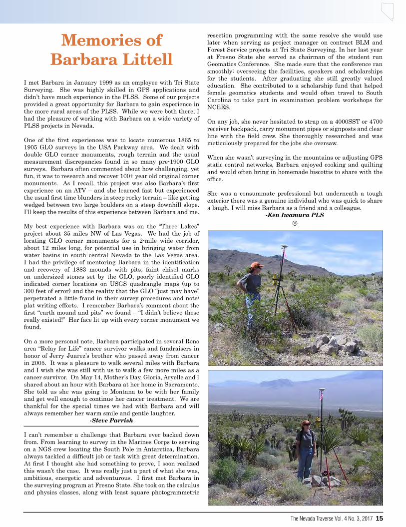
Memories of Barbara Littell
I met Barbara in January 1999 as an employee with Tri State Surveying. She was highly skilled in GPS applications and didn’t have much experience in the PLSS. Some of our projects provided a great opportunity for Barbara to gain experience in the more rural areas of the PLSS. While we were both there, I had the pleasure of working with Barbara on a wide variety of PLSS projects in Nevada.
One of the first experiences was to locate numerous 1865 to 1905 GLO surveys in the USA Parkway area. We dealt with double GLO corner monuments, rough terrain and the usual measurement discrepancies found in so many pre-1900 GLO surveys. Barbara often commented about how challenging, yet fun, it was to research and recover 100+ year old original corner monuments. As I recall, this project was also Barbara’s first experience on an ATV – and she learned fast but experienced the usual first time blunders in steep rocky terrain – like getting wedged between two large boulders on a steep downhill slope. I’ll keep the results of this experience between Barbara and me.
My best experience with Barbara was on the “Three Lakes” project about 35 miles NW of Las Vegas. We had the job of locating GLO corner monuments for a 2-mile wide corridor, about 12 miles long, for potential use in bringing water from water basins in south central Nevada to the Las Vegas area. I had the privilege of mentoring Barbara in the identification and recovery of 1883 mounds with pits, faint chisel marks on undersized stones set by the GLO, poorly identified GLO indicated corner locations on USGS quadrangle maps (up to 300 feet of error) and the reality that the GLO “just may have” perpetrated a little fraud in their survey procedures and note/plat writing efforts. I remember Barbara’s comment about the first “earth mound and pits” we found – “I didn’t believe these really existed!” Her face lit up with every corner monument we found.
On a more personal note, Barbara participated in several Reno area “Relay for Life” cancer survivor walks and fundraisers in honor of Jerry Juarez’s brother who passed away from cancer in 2005. It was a pleasure to walk several miles with Barbara and I wish she was still with us to walk a few more miles as a cancer survivor. On May 14, Mother’s Day, Gloria, Aryelle and I shared about an hour with Barbara at her home in Sacramento. She told us she was going to Montana to be with her family and get well enough to continue her cancer treatment. We are thankful for the special times we had with Barbara and will always remember her warm smile and gentle laughter.
-Steve Parrish
I can’t remember a challenge that Barbara ever backed down from. From learning to survey in the Marines Corps to serving on a NGS crew locating the South Pole in Antarctica, Barbara always tackled a difficult job or task with great determination. At first I thought she had something to prove, I soon realized this wasn’t the case. It was really just a part of what she was, ambitious, energetic and adventurous. I first met Barbara in the surveying program at Fresno State. She took on the calculus and physics classes, along with least square photogrammetric
resection programming with the same resolve she would use later when serving as project manager on contract BLM and Forest Service projects at Tri State Surveying. In her last year at Fresno State she served as chairman of the student run Geomatics Conference. She made sure that the conference ran smoothly; overseeing the facilities, speakers and scholarships for the students. After graduating she still greatly valued education. She contributed to a scholarship fund that helped female geomatics students and would often travel to South Carolina to take part in examination problem workshops for NCEES.
On any job, she never hesitated to strap on a 4000SST or 4700 receiver backpack, carry monument pipes or signposts and clear line with the field crew. She thoroughly researched and was meticulously prepared for the jobs she oversaw.
When she wasn’t surveying in the mountains or adjusting GPS static control networks, Barbara enjoyed cooking and quilting and would often bring in homemade biscottis to share with the office.
She was a consummate professional but underneath a tough exterior there was a genuine individual who was quick to share a laugh. I will miss Barbara as a friend and a colleague.
-Ken Iwamura PLSU

• SURVEY MARKERS & MONUMENTS• CONCRETE MARKERS & DRILL BITS• SURVEY NAILS & WASHERS• REFLECTIVE TARGETS & PRISMS• FLAGGING & WITNESS POSTS
SURVEY MARKING PRODUCTS
ORDER BY PHONE877.686.8561
FIND US ONLINEwww.berntsen.com
CONTACT US BY [email protected]
MARKING THE INFRASTRUCTURE OF THE WORLD™ | WWW.BERNTSEN.COM

AERIAL PHOTOGRAPHYDIGITAL PHOTOGRAMMETRY
DIGITAL ORTHOPHOTOGRAPHYGEOGRAPHICAL INFORMATION SYSTEMS
Our Commitment to Qualityand Service
Will Always be Our #1 Goal
2175 Green Vista Dr.Suite 207
Sparks, Nevada 89431Tel: 775-673-6000Fax: 775-673-6010
4011 W. Cheyenne Ave.Suite B
No. Las Vegas, Nevada 89032Tel: 702-646-1732Fax: 702-646-2050
88 Inverness Circle EastSuite B103
Englewood, CO 80112Tel: 303-792-5510Fax: 303-792-5512
QUALITY BEYOND
MEASUREEASY ONLINE ORDERING!
Your Satisfaction, Guaranteed.
SURVEY MARKERS, CAPS AND ACCESSORIES
800-445-5320

Program Statement The Land Surveying and Geomatics program is com-
mitted to addressing the diverse and constantly changing needs of students throughout Nevada and in other locales
who are preparing for a geomatics career by improving teaching methods, techniques, and content for delivering high
quality educational experiences and achieving student success.
LSG P
ROGR
AM HI
GHLIG
HTS
2 year AS Degree in Land Surveying and Geomatics 4 year BAS Degree in Land Surveying and Geomatics Quality of Instruction: 100% pass rate on the NCEES
Fundamentals of Surveying Examination Competitive Wages: average graduate mean salary
$50,000 - $75,000 Affordable: average graduate student loan debt 0$ - $5,000 Accessible: program offers 100% of the courses
online and through mentoring programs. 2015 LSG graduate survey ranked the quality of this
program as “excellent”
Great Basin College Land Surveying/Geomatics Program Great Basin College 1500 College Parkway, HTC 130 Elko, Nevada (USA) 89801 Phone: (775) 753-2344 www.gbcnv.edu

SuStaining MeMberS
Following is a listing oF sustaining members oF the nevada association oF land surveyors. Please remember that these Firms and businesses, through their nals membershiP, are suPPorting the aims and objectives oF our association.
Become a Sustaining Member Today!NvLandSurveyors.org
Aerial Mapping Consultants4011 W. Cheyenne Avenue, Ste. A
North Las Vegas, NV 89032T. (702) [email protected]
t
AeroTech Mapping2580 Montessouri St., Ste. 104
Las Vegas, NV 89117T. (702) 228-6277F. (702) 228-6753
t
Berntsen International, Inc.PO Box 8670
Madison, WI 53708Reno, NV 89511
T. (608) 249-8549www.berntsen.com
t
Paul R. Wolf’s Artisan Surveying Group
Las Vegas Pioche McGillPO Box 33434
Las Vegas, NV 89133T. (702) 233-3451
t
Monsen Eng. Supply1140 Financial Blvd., #400
Reno, NV 89502-2381T. (775) 359-6671F. (778) 359-6693
t
NDOT1263 S. Stewart St.
Carson City, NV 89712T. (775) 888-7034F. (775) 888-7203
t
Nevada Transit & LaserMike Riley
5720 S. Arville, #110Las Vegas, NV 89118
T. (702) [email protected]
t
Nevada Transit & LaserJoe Schneiderwind
745 E Greg Street, #2Sparks, NV 89431T. (775) [email protected]
t
North American Mapping, Inc.David Gray
2175 Green Vista Dr., #207Sparks, NV 89431T. (775) 673-6000F. (775) 673-6010
t
Spencer B. Gross of NevadaAndy Daniels
475 Hill St., Ste. #CReno, NV 89501-1816
T. (775) 826-4240F. (775) 826-5369
t
Tri-State Photogrammetry1925 E Prater Way
Sparks, NV 89434-8938T. (775) 358-9491F. (775) 358-3664
t
Vertical Mapping Resources, Inc.Joeseph Bartorelli
18140 Wedge ParkwayReno, NV 89511
T. (775) [email protected]
t

20 The Nevada Traverse Vol. 44, No. 3, 2017
Professional ListingsContact Editor for
Business Card Placements
YourBusiness Card
Here
YourBusiness Card
Here
YourBusiness Card
Here
YourBusiness Card
Here
YourBusiness Card
Here

The Nevada Traverse Vol. 4 No. 3, 2017 21
NALS Family Night With The AcesContributed by Justin Moore, PLS
This year the Lahontan Chapter of NALS decided to have a “Family Night with the Ace’s” in lieu of our traditional summer barbecue held in June. By all measures it was an amazing night for the organization and all the families in attendance.
Speaking of attendance, we had sold ALL of our 60 reserved tickets, which made for an excellent turn out and great NALS presence. All NALS associates and family members in attendance received a ticket to the game for seating within the Coors Light Party Zone, BBQ buffet, baseball hat and a fireworks show after the Ace’s victory! Kids after the game also had the opportunity to run the bases and meet Archie the Ace’s mascot.
A highlight of the evening was when NALS - Lahontan Chapter was also recognized on the massive scoreboard during the middle of the 4th inning. Feedback from the attendees was highly positive and it sounds like next year could be even bigger and better. So keep your eyes and ears open for tickets next week year, tickets are limited and when they’re gone...they’re gone. U
NALS Adopts Code Of EthicsThe NALS Board of Directors recently adopted the “Guidelines for Processing Violations of the Code of Ethics”. The “Guidelines” spell out the manner in which an alleged violation of the Code of Ethics will be processed.
Generally, the process would be as follows: A complaint received by the local Chapter Secretary against anyone engaged in the act of surveying within the State of Nevada who is believed to have violated the Code of Ethics. This must be well documented and be of first-hand knowledge and be signed by the complainant. The Chapter’s Ethics Committee determines if the complaint has sufficient grounds for further processing. Assuming that a violation is probable, the initial complaint is sealed and the Ethics Committee thereafter becomes the complainant for the remainder of the process. The Ethics Committee renders its recommendation to the Chapter’s Ethics Advisory Board. This Board then makes the decision whether to dismiss the case or to accept or modify the recommendations of the Ethics Committee and then to notify the recalcitrant surveyor in the instance of a verified violation. The Surveyor may appeal an adverse decision within 10 days to the State Level and the process is repeated. The State Ethics Advisory Board’s decision is binding on the Chapter and ends the appeal process.
A maximum of 90 days will elapse to render the decision of the Chapter’s Ethics Advisory Board or, if appealed, then a maximum of 150 days will elapse.
Adverse decisions may include a letter of reprimand, expulsion from the Association, referral to the State Board of Registered Professional Engineers (for violations of State and Local laws) or a combination of these.
A violation of State and Local laws is an example of the Code of Ethics. For example, did you know that a record of survey must be filed within 90 days after the establishment of points or lines under those certain conditions spelled out in N.R.S. 625.340? Or did you know that a surveyor employed on a full-time basis by State or Local Government shall not engage in private surveying practice on the regular workdays of that Government in accordance with N.R.S. 625.570?
In a period of time such as we have been experiencing within the past several months in which we have witnessed the public disgrace of certain professionals locally and across the Nation, the timing has never been more appropriate than now to begin a commitment to regain the high respect and confidence that the overwhelming majority of us deserve.
Doug HopkinsPete DuCharmeCo-chairmen, State Ethics Committee
Editor’s Note:OMG! What are we going to do? This is totally uncalled for. But wait…
This was actually taken from the Nevada Traverse Issue No 2: Spring of 1975.
CONTINUED ON PAGE 32 u

22 The Nevada Traverse Vol. 44, No. 3, 2017
Recruiting Future Land Surveyorsby Shane TrotterSenior Capstone Project Edited for the Nevada TraverseGreat Basin College Land Surveying and Geomatics Program
Introduction
According to the Bureau of Labor Statistics there are currently 43,340 land surveyors practicing in the United States, down from the 55,000 that were employed in 1974. The current number of land surveyors, in the United States, is lower than the projected amount for 1986, which was 86,600 (Bureau of Labor Statistics 1980). Currently the average age of a licensed land surveyor in the United States is over 55 years old per the online article “Is Surveying a Dying Profession?” by Dr. Francis Derby. There are less than 9,000 surveyors under the age of 34 in the United States according to Valerie King in her article “A Shortage of Surveyors?” published in POB magazine on June 1, 2016. Last December, the National Council of Examiners for Engineering and Surveying (NCEES) created a task force on the future of surveying. According to Tom Webb in a guest column for POB magazine on August 1, 2015, a principal charge to that group is to ascertain what NCEES can do to mitigate the dwindling number of candidates seeking licensure as a professional surveyor. A key factor contributing to the rate of incoming surveyors is the profession’s awareness-spreading deficiency (King 2016). Sharing information about the role of surveyors is essential at a time when the general public doesn’t necessarily have a clear understanding of what a surveyor’s role in society is (King 2016). Currently in Nevada, roughly 50% of the 410 licensed surveyors (Bureau of Labor Statistics 2016) will be eligible to retire in the next decade, based on national averages (Derby 2015). Nevada licensed less than 50 new surveyors from 2013 to 2016, and over 80 from 2010 to 2012. There was a large influx of new licensees from 2010 to 2012 because that was the last of the surveyors that could obtain their licenses without having a four-year degree. In 2013, 2015, and 2016, 13 surveyors were licensed each year, and in 2014 only nine new surveyors were licensed (Nevada PLS Roster). To meet the demand for future surveying services in Nevada and in the United States, a recruitment strategy must be deployed to raise the profile of the surveying profession. This paper will demonstrate one method to spread awareness and generate interest in the career of land surveying. Literature Review
A Shortage of SurveyorsThe National Society of Professional Surveyors (NSPS) is taking steps towards protecting the future of land surveying by launching the young surveyors network. There is still a need to get more young surveyors into the profession. The NCEES statistics have shown that there has been a decrease in the number of people taking the national PS and FS exams over the last several years. The average age of a surveyor, in 2016, was between 58 and 60 years old, and there will soon be a shortage of surveyors. NCEES and NSPS are currently holding meetings to find a solution to the problem, but they have limited time. As a Profession, Surveyors Must Evolve
Webb doesn’t believe that the overall decline in surveyors is due to a bad economy, increased exam difficulty or underpayment of services. According to Webb, NCEES fails to grasp the problem because NCEES stated that value in licensure will feed the growth of new land surveyors. The problem comes from the surveyors themselves. Surveyors have limited themselves to a shrinking demographic by their choices in recruiting, hiring and mentoring. Webb’s final sentence sums up the dilemma very nicely, “Our future will be determined not by the prodigies of technology, not even by the ebb and flow of populations, but by the acts of individual surveyors who either open the door to others in a generation of new colleagues, or who turn their back on their, and our future”. If land surveyors do not want to die out, we must act now and began mentoring, helping and recruiting future land surveyors.
Is Surveying a Dying Profession?Derby contends that the public perception of surveying is that surveying is less than other professions such as engineering and computer science. People look upon surveying as a trade and relate it to construction activities. The future tools of surveying are an opportunity to improve the profession and the amount of interest in it. Surveyors must adopt the new and exciting technology in order to attract more students. As Derby puts it, “The downward trend in enrollments will change if high school students are informed about the emerging opportunities in surveying beyond boundary surveying”.
Study Area
My first study area was the Nevada Association of Land Surveyors conference. This was the largest gathering of Nevada professional land surveyors that I could attend. I had over 25 professional land surveyors fill out my questionnaire. It was important to attend the conference because I wanted the input of professional land surveyors on my project. I was also able to gain interest, from surveyors, in the results of my study. I found several surveyors that wanted to see my results and had great interest in my project.
The second area of my study was the two high school classrooms where I gave my presentation. High school students were my chosen target audience because they are close to entering a career field or area of study, but have not started college or entered the workforce. The first class that I presented to was a 9th grade honors algebra class. I chose to present to the math class because I could relate survey problems to the math that they were learning. The second class that I presented to was an engineering class, which was composed of students ranging from 9th to 12th grade. I wanted to present to this class because they had an idea of what engineering was, and I wanted to see if they had knowledge about land surveying.
Methods
I used three different surveys to track my research. The first survey was given to professional land surveyors attending the NALS conference. This survey contained questions that would allow me to examine how and why each surveyor became a licensed professional. They also considered whether the surveyor had planned to become a land surveyor at a younger age, or if it was a career that they evolved into (Table 1).
The second and third surveys were entrance and exit surveys CONTINUED ON NEXT PAGE u

The Nevada Traverse Vol. 4 No. 3, 2017 23
that I gave to the high school students (Table 2 and Table 3). The entrance survey was provided to each student prior to my presentation. It was used as a baseline to find out each student’s current knowledge of the land surveying profession and compare it to their current knowledge of the engineering field. The entrance survey also asked the students if they had an interest in pursuing the career of land surveying. The exit surveys were taken by the students in both classes after the presentation. The exit survey again asked about their knowledge of land surveying and whether they would consider a career in this field.
NCEES Speakers KitThe NCEES speakers kit was developed to help surveyors talk about land surveying at schools. It includes a power point presentation which can be adjusted by the presenter. The presentation is mainly made up of bullet points. It is targeted at why licensure is important and the process to become licensed.
To provide information and educate the students, I created a PowerPoint presentation. From “10 Tips for Powerful PowerPoint Presentations” by Quora, taken from Forbes online, I learned that it is important to maintain eye contact with the audience/students. I had to practice when my slides would be switched, and I found that it worked best if I switched the slides myself. I gave the students breaks in the presentation by mixing in written problems. I used the white board to work out survey problems and demonstrate to the students why land surveying was important.
The Scientific Reason Why Bullet Points Are Bad for PresentationsBullet points make information much more difficult to retain, especially when the presenter is talking while an audience is reading them. Power point slides with visual aids have been proven to be undeniably more effective than bullet points by The Journal of Business Communication. Dr. Atherton has shown that it is cognitively exhausting for a person to continuously switch from reading bullet points to listening. The cognitive exertion can be minimized by using images that help the audience remember the information that is given. The images can also be used to help convey complex ideas or to stimulate the audience and capture their attention.
After I completed my research on creating a captivating power point and with help from my professor, Byron Calkins, I determined that it would be best to utilize a PowerPoint that contained mainly images rather than bullet points. Each presentation lasted 40 minutes to an hour depending on how many questions the students asked. I focused the presentation on the history of land surveying, what a land surveyor does, the tools that a land surveyor uses, and the exciting aspects of the land surveying profession. Telling the students about my experience of getting paid to go hiking and look for section corners, traveling around Nevada and being able to work outdoors captured their attention and kept them interested. I broke up the presentation by working out survey related problems, which also related to the students’ knowledge of math. My main objective was to captivate the students’ attention and generate interest in the subject, however, I did take the time to explain to the students what was required to become a PLS.
Results
Looking at Table 1 “Current Land Surveyors,” it contains
tabulated numerical data from the questionnaires that I gave to the land surveyors at the NALS conference. This data indicated that the youngest age that a person decided to become a Professional Land Surveyor (PLS) was 17 and the oldest was 45, with an average age of 27. The average age that a person obtained their license was 34 years old. The average age that a person was first told or heard about land surveying, was 19 years old—well after high school graduation.
I made two tables to tabulate the results from the two questionnaires given to the high school students. The first table displays the entrance survey results. These results showed that 58% of the students knew what civil engineering was, 29% of them would consider a career in civil engineering and 22% of them might consider a career in civil engineering. 38% of the students knew what the requirements were to become a licensed engineer. The entrance surveys also revealed that 16% of the students knew what land surveying was and 13% would consider a career in land surveying. Only 13% of the students knew what the requirements were to become a licensed land surveyor. The average age of the students that took the entrance survey was 16 years old with the oldest student at 18 years old and the youngest student at 14 years old.
The second table displays the results from the exit survey. I did not give the students any additional information on Engineering, so I did not question them on this subject with the exit survey. 95% of the students could successfully describe the profession of land surveying and 77% might consider a career in land surveying. The average age of the students that took the exit survey was 15 years old with the oldest being 18 years old and the youngest 14 years old. Analysis
The first survey that was provided to the land surveyors at the NALS conference showed two important discoveries. The first was that most of the surveyors did not graduate high school intending to become a PLS. The average age that they first heard about land surveying was 19 years old. It was also shown that most of the land surveyors decided to become land surveyors because it was the next thing to do in their current profession. In other words, they “fell” into the land surveying profession and they wanted to continue to progress in the field. This was proven by three questions in my survey. The first, which could not be tabulated numerically was the question, “Why did you become a PLS?” The overall answer for this question was that the surveyor wanted to advance in the field. The average age that the PLS decided to become a professional was 27 years old which shows that they had spent some time working in the survey field before they made their decision to obtain a license. Lastly, the average age that the surveyors obtained their license was 34 years old. If the surveyors did not “fall” into the profession, then these average ages would be much lower.
The entrance survey, given to the high school students, showed that most high school students do not know what land surveying is, so they are not able to consider a career in the field because they do not even know it is an option. An alarmingly high number of students, 84%, did not know what land surveying was. There were many students who thought they knew what land surveying was, but did not. Some of the students assumed that land surveying was purely focused towards agriculture and farming or surveying the land for different soil and vegetation types.
CONTINUED ON PAGE 30 u
Recruiting Future Land Surveyors... continued from previous page

24 The Nevada Traverse Vol. 44, No. 3, 2017
MINUTES
ROLL CALLAlan Dill, PresidentJerry Juarez, President ElectDoug Wood, TreasurerCarl CdeBaca, Immediate Past PresidentJustin Moore, Director LahontanGreg Phillips, Director Lahontan
GuestsMatt Gingerich, Past President, WFPS DelegateCrissy Willson, NALS Executive Office
AbsentHalana Salazar, SecretaryJeff Miller, Director Southern NevadaJason Fackrell, Director Southern Nevada
OFFICER REPORTSOfficers provided an update on activities over the last quarter.
TREASURER’S REPORTTreasurer Doug Wood reviewed the financial reports as included in the agenda.
MOVED by Jerry Juarez and SECONDED to accept the financial reports as included in the agenda. MOTION CARRIED.
AWARDS CRITERIAThe Board of Directors previously discussed the need for the NALS awards process to be reviewed. Included in the agenda were recommended awards criteria and guidelines.
MOVED by Doug Wood and SECONDED to adopt the criteria and guidelines for the Surveyor of the Year with the amendment of removing the exclusion of members of the Board of Directors as potential recipients. MOTION CARRIED.
MOVED by Jerry Juarez and SECONDED to adopt the criteria and guidelines for the Meritorious Award with the amendment of removing the exclusion of members of the Board of Directors as potential recipients. MOTION CARRIED.
Action Item: Executive Office to develop a nominations form for the Board to review.
CORRESPONDENCEPresident Alan Dill reported that a letter was sent to Professional Land Surveyors of Colorado in support of their efforts to obtain mandatory continuing education.
As directed at the April Board of Directors meeting, a
letter was sent to the City of Reno regarding conflict in administrative code. No response has been received to date. Carl suggested that anytime a violation is found that BPELS be copied on the correspondence.
Action Item: If no response by the City of Reno is received by August 25th NALS will follow up with a second letter copied to the Board of Registration.
ADVANCED EDUCATION COMMITTEEReport included in the agenda.
Chair Carl CdeBaca reported that GBC has a new President who comes from a campus that included a 4 year survey degree.
Action Item: Carl C.deBaca will be meeting with the GBC President to discuss potential of second professor for the survey program.
Action Item: Carl CdeBaca to participate in video conference with all students on the first day of school to promote the forming of a GBC team to compete in the NSPS Student Competition. Executive Office to draft a letter to be distributed to all students as follow-up.
MOVED by Jerry Juarez and SECONDED to recommend the NALS Foundation budget up to $7500 from the NALS/NSPS Equipment Fund to support GBC students and professor to participate in the NSPS Student Competition. MOTION CARRIED.
It was noted that UNLV is looking to fill a part-time professor position.
BOARD OF REGISTRATION LIAISONReport included in agenda.
Carl CdeBaca and Jason Fackrell continue to attend BPELS meetings on behalf of NALS. Carl emphasized the importance of this liaison position.
BYLAWS Proposed bylaws included in agenda. Overview distributed. (Attached)
The Board of Directors indicated that additional time was needed to review the bylaws proposal. A telephone conference call to discuss the bylaws was scheduled for August 21, 2017 at 2:00 PM.
WEBSITECrissy Willson reminded everyone to update their profile on the website and add to their Find a Surveyor listing. Please encourage other members to do the same during chapter
NALS Board of Directors MeetingFriday, Month 21st, 2017 • Via Telephone Conference
CONTINUED ON NEXT PAGE u
The Nevada Traverse Vol. 4 No. 3, 2017 25
meetings.
CONFERENCECrissy Willson reported that NALS will need to provide volunteers to solicit sponsorships and exhibitors. Jerry Juarez, Alan Dill, and Matt Gingerich will serve in this role.
TRIG-STARReport included in agenda.
Action Item: Jerry Juarez to provide an updated report indicating how many students participated in the program.
LEGISLATIVE COMMITTEEReport included in agenda.
Carl CdeBaca was reappointed Legislative Chair for 2017 and 2018.
NSPS FOUNDATION Report included in agenda.
Carl CdeBaca reported that NALS request to award Steve Parrish funds from the Atwell Fund was fulfilled.
WFPS DELEGATEReport included in the agenda.
Final Point for Jerry Tippin will be set in Lake Tahoe. Lahontan Chapter will work on allocation funds to help offset costs.
WFPS Delegate Matt Gingerich reported that Federal funds are available for workforce development.
Action Item: Matt Gingerich to email information regarding workforce development.
GREAT BASIN CHAPTERReport included in agenda.
LAHONTAN CHAPTERReport included in agenda.
SOUTHERN NEVADA CHAPTERAlan Dill reported that a lunch meeting was held for the first time and it resulted in a larger attendance than the Chapter has realized in the past.
The SNALS Golf Tournament will be held October 21st (day after the NALS Board Meeting) in Mesquite, NV. The registration information is posted on the NALS website.
PROFESSIONAL PRACTICE COMMITTEENo action taken. Keep on the agenda for the October meeting.
REQUEST FOR PROFESSOR AT WESTERN NEVADA COLLEGE
Western Nevada College is looking for assistance with their fall classes.
Action Item: Greg Phillips and the Lahontan Chapter will see if they can identify someone to assist on Saturdays in the fall at the Western Nevada College.
LETTER TO CONTRACTORS BOARDA draft letter to the Contractors Board of Registration was included in the agenda.
Carl CdeBaca recommended that the letter be copied to the Board of Registration.
Action Item: Board members to submit feedback to Alan by August 15th. Letter will be redrafted and provided to the Board for final approval and carbon copy to the Board of Registration.
NEXT BOARD MEETINGTelephone conference call on August 21, 2017 at 2:00PM.October 20th at 10:00 AM at the Luxor in Las Vegas, NV.
ADJOURNMENTPresident Alan Dill adjourned the meeting at 1:20 PM.
U
NALS BoD Minutes... continued from previous page
NALS Historic Committee
SearchThe Historic Committee is searching for
pictures and narratives on past presidents
and prominent contributive members.
The presidents are known, but a list of
contributive members needs to be developed.
This year we hope to collect an overview of
recollections, contributions and photos for
both categories for future use. Respondents
need not worry that two or more reply;
information and photos received will be
compiled by the committee.
Please respond to:
Thank you!

26 The Nevada Traverse Vol. 44, No. 3, 2017
Drones and Land Surveying From The Nevada Board Of Professional Engineers and Land SurveyorsThank you to the California Board for Professional Engineers, Land Surveyors, and Geologists for their well written article on Unmanned Aerial Vehicles and Land Surveying Practice in California by Steve Wilson PE/PLS (CA), and Dallas Sweeney, PLS (CA). Because we are experiencing similar challenges in Nevada, we appreciate California’s willingness to grant Nevada permission to use and modify portions of their original article printed in Spring 2017 Bulletin, Volume 4, Number 1.
Drones and Land Surveying
With rapidly evolving technology, the tools used by land surveyors to produce accurate topographic maps have drastically changed. Twenty years ago, land surveyors collected field data one survey point at a time using theodolites, steel chains, and rodmen—typically requiring three or more people. And, photogrammetric mapping was done with an airplane equipped with expensive high-resolution aerial camera equipment. Now, survey data can be collected by one person using robotics and global positioning systems, terrestrial scanners, and low-altitude drones. Regardless of how field data is collected, a land surveyor must be in responsible charge of the process to locate fixed works designed by a civil engineer and in determining alignments and elevations.
Drones and readily available software are significantly cheaper than airplane photography and stereo-plotters to capture and orthogonally rectify photo images to the shape of the earth. The availability of drones and ease of use has tempted some to enter into the unlicensed practice of land surveying.
Entrepreneurs are opening new companies to offer services such as drone flight planning, piloting, and photography. Drones are regulated by the Federal Aviation Association, but drone activity related to mapping is not regulated by Nevada’s land surveyor laws. However, Nevada law does regulate land surveying. And the production of any work depicting the locations or elevation of what is captured in photography relative to the earth’s surface is considered mapping and is described in Nevada law as the practice of land surveying which is regulated by the Nevada board.
In converting photo images to useful data, a land surveyor manipulates the images using field auditing procedures. The process verifies that ground control points and software mapping are accurate and are within project specific tolerances.
Any civil engineering or architectural product, when designed in relation to any property boundaries, setbacks, or existing physical (fixed) improvements, requires dependable and
accurate topographic information. No matter what tools are used to gather and depict the field data, the responsibility and liability for accuracy lie with the professional authorized to practice land surveying. Professional land surveyors are required to be responsible for the accuracy and correctness of their work. Mapping produced by those who may not have the training, education, and experience and who have not proven themselves competent to recognize potential errors or inaccuracies has the potential to cause harm to the public from any number of problems that may arise during subsequent use of the data. It is in the best interest of all design professionals to insist on accurate and reliable mapping.
When is a drone operator performing land surveying?
Simply put, when the operator creates a topographical survey or overlays a boundary on an orthogonally rectified photo and provides the finished product to a private client or public agency, the operator must be authorized by law to perform land surveying. Persons who offer to do more than flying a drone and obtaining the photography would be violating the law if their services also include orthogonally rectifying the photography to the surface of the earth or preparing a map that shows the alignment and elevation of fixed works, unless that work is performed by, or under the responsible charge, of a licensed professional land surveyor.
How can the Nevada Board of Professional Engineers and Land Surveyors help?
One approach is education. The board is available to collaborate with Nevada professional organizations to educate drone users by explaining which processes must be done by, or under the responsible charge of, a person authorized to perform land surveying. This might be helpful to reduce the possibility of offering unlicensed land surveying services.
The other approach is through enforcement. If you know of an individual or company that you believe is offering unlicensed land surveying services, contact the board. You can either submit an inquiry or file a complaint. We will contact the individual or company and discuss with them how they might be violating the law. Based on this contact and the response or actions of the individual or company, the board will determine the appropriate course of action. U
Summer is Almost Over
Western Regional Survey Conference
• 24 Hours Continuing Education • Workshops • Technical Sessions • CFedS Credits Available
• Exhibits & Vendor Demos
• Silent & Live Auction
February 21-24, 2018 Luxor Hotel & Casino, Las Vegas, NV
Mark Your Calendar!
WFPS, South E Street, Santa Rosa, CA 95404 (888) 994-3510
Conference Registration at: www.PLSeducation.org
Conference Sponsored by: APLS NALS UCLS WFPS
WFPS Conference 2018 AD FP.indd 2 8/22/17 4:03 PM

28 The Nevada Traverse Vol. 44, No. 3, 2017
WFPS Report
NEVADA ASSOCIATION OF LAND SURVEYORS STATE BOARD MEETINGJuly 21, 2017
14.4 Western Federation of Professional Surveyors
The Western Federation of Professional Surveyors Board of Directors meeting was held on June 24, 2017 in Boise, Idaho. The meeting was attended by Nancy Almanzan and Matt Gingerich.Highlights from the meeting follow:
TWISTThe TWiST program has been suspended for 2017. This decision was made by the Oregon Institute of Technology and Tim Kent. Tim and his team are reviewing the program and may make changes for 2018.
ALASKAMembership: Approximately 220Conference: 2018 in Anchorage, and 2019 with WFPS
BLM’s proposal to the Alaska Department of Natural Resources to generate cadastral survey plats with no field monumentation but just listing coordinates for positions is still being discussed.
ARIZONAConference: APLS is participating in the 2018 Western Regional Conference along with Nevada, Utah, and WestFed.
Legislation: In addition to the normal sunset process, the Governor issued an Executive Order (attached) requiring the Board of Technical Registration (BTR) to submit an additional report outlining the need for licensure in the state. The BTR responded by the June 30th deadline and APLS is currently drafting a response.
COLORADOConference: March 7-9, 2018 Arvada CenterMembership: 529 members
Legislation: The PLSC Legislative Committee was successful in defeating a bill to eliminate the requirement for County Surveyors. The PLSC Legislative Committee will be pursuing a continuing education requirement for Colorado.
Education: PLSC volunteers have been working hard to establish a Survey Degree Program in Colorado (see attached curriculum). Our first step has been realized with the establishment of a program through Western Colorado Community College and Colorado Mesa University.
HAWAIIMembership: 86 members
Conference: February 15 &16, 2018 Honolulu, Hawaii – Steve Parish “Restoration of Lost or Obliterated Corners”
IDAHOIPLS has partnered with the US Department of Labor and the Idaho department of Labor to offset the cost of internships for those entering into the profession. This program allows companies to be reimbursed for some cost associated with training the intern. It has been a success encouraging hiring of young people interested in the profession.
NEW MEXICOConference: April 28-29, 2016 – Albuquerque, NM
Education: NMPS has committed to raising $100,000 per year for supporting an additional faculty member of for New Mexico State University Geomatics program. Attached is the pledge form.
OREGONMembership: 606Conference: January 17-19 at the Salem Convention Center
Bailey v. Parker – Oregon Supreme Court: In a Circuit Court, the judge made what PLSO believes was the wrong decision regarding a boundary call to the center of a creek. Said judge ruled the boundary to be a straight line between the beginning and ending creek calls, and even re-wrote the legal descriptions of the two parties to that effect. PLSO member Lee Spurgeon, no stranger to testifying in the courts as expert witness, prepared the initial draft of an Amicus Brief to submit to the Supreme Court. PLSO hired a land use and water attorney to review, polish and submit the brief. The Oregon Supreme Court accepted the brief but declined to take on the case. The bad news is that the Court of Appeals affirmed the Circuit Court decision “without opinion,” harming Bailey by taking property and access to the creek. The only good news is that “without opinion” means Bailey v. Parker does not set a legal precedent.
UTAHMembership: 400Conference: The 2018 Conference will be in conjunction with Nevada, Arizona and WFPS in Las Vegas, Nevada
WASHINGTONMembership: 934Conference: How the West was Drawn, March 2-4, 2016 Tulalip Resort.
LSAW formed a committee to address issues and to help members prepare for the adoption of the 2022 NGS NSRS datum. Washington laws mandate NAD83.
WYOMING
The University of Wyoming now has in place a Minor in Land Surveying and a Land Surveying Certificate program. Last semester had 123 students from 26 states, who took a total of 680 semester hours.
NEXT MEETINGS
October 21, 2017 in Las Vegas, Nevada.U U

The Nevada Traverse Vol. 4 No. 3, 2017 29
CONTINUED ON PAGE 32 u
Lahontan Chapter Reportby Justin Moore, PLS, President - Lahontan Chapter
Following the conference in April the Lahontan Chapter had it final meeting on May 10th before we broke for the summer break. Mark Morberg with the Bureau of Reclamation was our guest speaker. He discussed the role of the Bureau and their upcoming projects on local reservoirs. Mr. Morberg is located in Sacramento, CA and it was an honor to have him travel to Reno and speak to our Association.
To kick off our summer 2017, the Lahontan Chapter also hosted a Family Night with the Ace’s (AAA baseball team). This was in lieu of the traditional family picnic which over the past few years has had poor turn out (15-25 total). This year for the Ace’s game we sold 61 tickets total. Turnout was triple of what we normally see and the venue was the same cost to the association as previous picnics.
The Lahontan Chapter will be taking the next 3 months off of our monthly meetings. The summer months tend to be very busy for all of us and attendance in generally down. So we take a little break and regroup for the fall of 2017, resuming our monthly meetings in September. Our fall schedule will remain the same for monthly membership meetings being the 2nd Wednesday of each month at the Twisted Fork in Reno. Guest Speakers for the fall are still being finalized. We are also in the works of planning our fall workshop. We are looking at a Friday in October to hold an 8 hour workshop for folks still needing some PDH’s or looking for some general knowledge.U
Great Basin Chapter Reportby Christopher S. Konakis, PLS, WRS, President
PAST ACTIVITIES
April Meeting: April 10, 2017 at the Gold Dust West Casino, Elko, NV; 7 members present.May Meeting: May 8, 2017 at the Gold Dust West Casino, Elko, NV; 5 members present.June Meeting: June 12, 2017 at the Gold Dust West Casino, Elko, NV; 6 members present.
Great Basin Chapter Picnic: The annual chapter picnic was held Saturday July 22, 2017 at the Nisbet Cabin in Lamoille, NV.
PLANNED ACTIVITIESJuly Meeting: July 10, 2017 at the Gold Dust West Casino, Elko, NV.August Meeting: Time and Place TBDSeptember Meeting: Time and Place TBD U
GBC Celebrates Scholarship, Integrity and Camaraderie
On May 19th, 2017 at 8:00 P.M. Pacific Time, GBC Lambda Sigma members, Lambda Sigma selectees, family, and friends
Stakes made by the 2017 Lambda Sigma Selectees
convened at the Star restaurant in Elko, NV, to take a ceremonial oath to support and enhance professional and student land surveying and geomatics organizations in their growth and to encourage understanding and cooperation between surveying and other professions.
The Lambda Sigma Honor Society (Great Basin Chapter)

30 The Nevada Traverse Vol. 44, No. 3, 2017
Before presenting to the students only 13% of them said that they would possibly consider a career in land surveying. What was most apparent to me was the lack of knowledge of what land surveying was and what it took to become a land surveyor. Over 50% of the students looked at land surveying as a vocation or something you go to a trade school to learn. This agrees with Derby’s article where he stated that people look upon surveying as a trade and relate it to construction activities.
The results of the exit surveys indicated a massive increase in the number of students that would consider a career in land surveying. Before giving my presentation, 13% of students indicated they would consider a career in land surveying. The second survey showed that 77% of the students would consider a land surveying career, an over 500% increase. This means that for every one possible future land surveyor that walked into my presentation, five walked out! Not only was I able to increase the amount of potential future land surveyors, but I was also able to educate the students about land surveying and grasp their attention while doing it. After the presentation, 95% of students successfully described what land surveying is. This proved that they digested a large amount of the information given to them.
Conclusion
The main goal of my project was to find a way to increase the number of future land surveyors. The statistics gained from my research conclude that this is possible. I found that it was important to educate the students about the requirements of land surveying, but it was more important to show them the exciting aspects of the occupation. It was best to lead in with the positives while including all other aspects of surveying. When scheduling my presentations at the high school, I discovered the
difficulty teachers have when trying to carve out time to allow someone to come into their class. The students had a tight schedule to keep, and they were so busy with tests and learning, that it was very hard to schedule a presentation with them. I think any presentation or demonstration of land surveying that requires a student to do more testing or work would be less useful than a presentation aimed at gaining their interest in a certain subject. A person will not become a PLS because they look forward to tough college courses, difficult math, and a long testing and licensing process. I agree with Webb and I think that the promotion, recruiting and mentoring must come from surveyors themselves. I urge every licensed surveyor to start mentoring and promoting the land surveying profession before it dies out. U
Know What Civil Engineering Is
Become A Civil Engineer
Know The Engineering
RequirementsKnow What Land
Surveying IsBecome A Land
Surveyor
Know The Land Surveying
Requirements AgeYES YES YES YES YES YES AVERAGE
26.00 13.00 17.00 7.00 4.00 6.00 15.56NO NO NO NO NO NO HIGH
19.00 22.00 28.00 38.00 41.00 39.00 18.00Percent Yes MAYBE Percent Yes Percent Yes MAYBE Percent Yes LOW
57.8% 10.00 37.8% 15.6% 2.00 13.3% 14.00Percent Yes Percent Yes
28.9% 8.9%Percent Maybe Percent Maybe
22.2% 4.4%
Know What Land Surveying Is
Become A Land Surveyor Age
YES YES AVERAGE37.00 12.00 15.47NO NO HIGH2.00 9.00 18.00
PERCENT YES MAYBE LOW94.9% 18.00 14.00
PERCENT YES30.8%
PERCENT MAYBE46.2%
Age 46 55 72 58 54 65 62 50 46 72 48 58 37 41 69 41 55 62 AVG. 55.1Race H H W W W W W W W W W W W W W WSex M M M M F M M M M M M M M M M M M MLevel of Education SC HS B HS HS SC B B B SC B M A SC HS SC SCAge Decided To Become PLS 26 30 24 18 43 26 17 34 23 24 32 30 26 20 33 23 19 45 AVG. 27.4Age First Heard of Land Surveying 18 19 19 9 28 16 10 34 23 19 32 13 20 20 19 20 19 12 AVG. 19.4Age Became PLS 35 33 29 32 45 28 30 42 29 25 39 41 29 31 35 31 26 45 AVG. 33.6Taught Children YES YES YES YES NO YES NO NO YES YES YES YES YES YES YES NO YES NO
Table 1 - Current Land Surveyors
SC – Some College | HS – High School | B – Bachelor Degree | M – Masters | Table 2 – High School Kids Before Presentation
Table 2 – High School Kids Before Presentation
Table 3 – High School Kids After Presentation
Recruiting Future Land Surveyors... continued from page 23
The Nevada Traverse Vol. 4 No. 3, 2017 31
forgiven. Godin was happy to let the matter drop. He took a position as the mathematics chair at the prestigious University of San Marcos, the oldest university in the New World. Perhaps there, as is so often the case, the teacher was able to learn something from the students.
Godin’s position at the university included the title of Royal Astronomer, which allowed him to profitably print almanacs and ephemerides. His income was equivalent to $200,000 per year, which true to form, he routinely squandered. But the post also carried the position of cartographer, architect and surveyor for the province’s Viceroy. This soon brought Godin some standing.
At 10:30, on the night of October 28, 1746 an 8.5 magnitude earthquake struck Lima, causing massive damage and taking thousands of lives. A half hour later a massive maremoto, or tsunami, struck Lima’s port facility at Calleo. The wave overtopped the city walls, destroying some ships moored in the harbor and carrying others far inland. The earthquake damaged or destroyed every building in Lima. Calleo simply vanished.
The Viceroy called on Godin to rebuild the devastated city. His surveying knowhow served him well, as he rejected moving the city to a different location, mapped the extent of the ruined city’s remains and set about rebuilding a new Lima. In the process, he began rebuilding himself. His plans for transforming the capital’s character with lower buildings and wider boulevards proved successful. He later reconciled with the Academy, and his wife. Godin decided to return to Europe and made plans to travel with the surgeon Jussieu, who had remained in Peru to treat the sick, in particular the Indians laboring in appalling conditions at the notorious silver mines of Potosí.
Jussieu was commanded by the Academy to bring the iron toise back to France, together with the surveying instruments and related gear. Furthermore, the Academy expected Jussieu to pay his own way. Godin did not want to part with the iron bar, so they agreed to travel together. But the surgeon’s desire to help the sick overcame his desire to return home. Godin sailed on to France alone. Jussieu remained at Potosí, treating Indians poisoned by the hundreds from the mercury used to reduce silver ore, or being worked to death in the underground. Jussieu stayed on for fourteen years, until he too was eventually poisoned by mercury. His friends took him to Lima to recuperate, but his mental and physical condition deteriorated.
Godin returned to Europe and at the urging of Jorge Juan, took a position with the prestigious Royal Observatory of the Spanish Navy at Cadiz, which Juan founded in 1757. Godin died there in 1760, at the age of 56. Jussieu finally returned to France in 1771, after 36 years in Peru. His memory obliterated, his priceless botanical collection and manuscripts simply thrown away, he died at his Paris home in 1779, at the age of 75.
The able draftsman and watercolorist Jean-Louis de Morainville and the tireless instrument maker Théodore Hugo were left behind, with no means to return to France. They petitioned the Academy for passage home, but to no avail. The bitter Hugo, whose work went utterly unrecognized by the expedition’s leaders, or the Academy, wrote, “I am therefore stuck here in Quito where I spend my life working off my debts by the sweat of my brow.”5 He gave up instrument and clock making, took up tile work and married a local woman. He died in Quito in 1781, leaving behind a family of eight. Morainville never married, relocated to Riobamba and died there, accidentally falling to his death in 1764.
EpilogThe British and French chose different paths in the quest to solve the great navigational problems of the Enlightenment. The British, in the pursuit of longitude, offered a monetary prize to the first Briton to produce a practical marine chronometer. John Harrison, the self-educated clock maker, succeeded in building one by 1736. He continued to improve his design, and after years of struggle to claim it, was grudgingly awarded his prize money in 1773. The French chose institutional, state-funded science to solve the spheroid. In the end, both revolutionized the navigational sciences of the Enlightenment. Often the persons most responsible for the rational application of science to the problems of the Enlightenment were in fact devout believers. They fused science with faith, merely two sides of the same eternal coin.
The Peruvian expedition inspired the likes of Alexander von Humboldt and Charles Darwin. And the pursuit of plumb-line deflection studies and measurements of other meridional arcs continued on for centuries. A list of large-scale arc projects undertaken after Peru includes names that we still recognize today: Roger Boscovich, S.J. in Italy, 1751; Nicolas-Louis La Caille in South Africa, 1752; Charles Mason and Jeremiah Dixon in America, 1766; Jean Baptiste Delambre and Pierre Méchain in France, 1791-996; George Everest in India, 1820-43; Friedrich Struve across Norway and on to the Black Sea, 1816-55.
Little remains from France’s geodesic survey in Peru. The great monuments built at the ends of the northern baseline fell into ruin and the massive grindstones set to mark the termini were obliterated. The instruments and clocks vanished. Louis Godin did return the iron toise to the Academy. It rests now at the Paris Observatory. One of La Condamine’s surviving marble plaques, together with a monument to the expedition, reside at the Quito Observatory. A few of Morainville’s watercolor paintings survive in the National Museum of Natural History in Paris. But many of the expedition’s members died without children and their family lines ended long ago. There was once a time when every literate person of the Enlightenment knew the names of Bouguer, La Condamine and Godin. Those days have passed into history. U
(Endnotes)1Lawrence Washington was present at the siege of Cartagena. Despite the defeat he was so impressed with Admiral Vernon that he named his Virginia Estate “Mount Vernon”. George Washington kept the name when he inherited the property from his older half-brother Lawrence.
2New York, Measure of the Earth, The Enlightenment Expedition That Reshaped the World, Larrie D. Ferriero, 2011, page
3Incredibly, La Condamine brought the 18-foot zenith sector with him on his journey down the Amazon. In Abridged Narrative of Travels through the Interior of South America he later wrote, “…I happily suc-ceeded in completing my observation, and thus reaped the first fruit of the toil which the transport of a telescope eighteen feet long, over mountains and through woods, for the space of one hundred and fifty leagues, must necessarily have occasioned.”
4Isabel’s ordeal is recounted in The Map Maker’s Wife, written by Rob-ert Whitaker and published in 2004.
5New York, Measure of the Earth, The Enlightenment Expedition That Reshaped the World, Larrie D. Ferriero, page
6The Académie des sciences named Méchain and Delambre to under-take a geometric measurement of the meridian that directly resulted in the establishment of the standard length for the meter.
The Power of Ideas, Part IV... continued from page 7

32 The Nevada Traverse Vol. 44, No. 3, 2017
Deuteronomy 27:17 Through The AgesNew International Version Cursed is anyone who moves their neighbors boundary stone. Then all the people shall say, Amen! New Living Translation Cursed is anyone who steals property from a neighbor by moving a boundary marker. And all the people will reply, Amen. English Standard Version Cursed be anyone who moves his neighbors landmark. And all the people shall say, Amen. New American Standard Bible Cursed is he who moves his neighbors boundary mark. And all the people shall say, Amen. King James Bible Cursed be he that removeth his neighbours landmark. And all the people shall say, Amen.
New BLM DPPS Policy Cursed be he that useth an incorrect datum or changeth his neighbours coordinates. And all the bureaucrats shall say, Ahem.
U
These were good ideas then and they are good ideas now. The
suggested Professional Practices Committee outline is merely a bit better
organized and more detailed, but no additional powers, responsibility
or liability are proposed in the PPC that aren’t already in the existing
Code of Ethics process adopted by our forebears over forty years ago.
In case you haven’t been paying attention, licensing boards across the
nation are under attack by various groups asserting that licensing of
professions restricts free trade. The U.S .Supreme Court recently handed
down a ruling that will tend to erode the power and stability of most
licensing boards, and will provide these anti-licensing crusaders with
a new weapon. If you are of a mind that it is not our job to police
ourselves, how will you feel, when no one is? Will the ‘free market’
straighten it all out? As one of our board members said recently, Boards
were legislated into existence and they can be legislated out of existence.
U
NALS Adopts Code Of Ethics... continued from page 22
GBC Celebrates... continued from page 29
Has Your ContactInformation
Changed?Change in your address, email address, or
telephone? Please contact NALS with
your updated information.
You may log onto the NALS Website at:
www.nvlandsurveyors.org
Go to: Update Contact Info.
Fill in your information and submit.
Help your NALS Board
to keep you current.
Thank you!
recognizes the fundamental characteristics of the successful
surveyor and geomatics professional and aids in the development
of scholarship, integrity, and camaraderie to promote knowledge
and acceptance of the surveying and geomatics profession.
According to the Lambda Sigma Code of Ethics, “None of these
characteristics is worth much unless we have the self-discipline
to follow a rather rigid routine. This takes eternal vigilance, and
a genuine belief and enthusiasm in our profession, which is, the
necessary catalytic agent in the development of a competent
professional.”
The Land Surveying and Geomatics program would like to thank
the Nevada Association of Land Surveyors and the Great Basin
Chapter for their generous $1000.00 dollar donation to host this
important ceremony and their continued financial support for
Great Basin College’s Land Surveying and Geomatics Program.
The 2017 donation from NALS provided the financial means to
honor and celebrate high scholastic achievement and honorary
service to Great Basin College’s Land Surveying and Geomatics
Program. U

ADVERTISER HOT LINKS To receive FREE information about products and services from advertisers featured in this issue of The Nevada Traverse, you may log onto the NALS Web Page at www.nv-landsurveyors.org, click on
Nevada Traverse, and you will find a hot link to the web sites of all advertisers in this issue. Using these links, you can go directly to the advertiser(s) of your
choice for inquiries, to request catalogs, training schedules and information, or placing orders.
ADVERTISER INDEX for this Issue
Berntsen International ......................................... 16
Carlson ................................................................... 16
Monsen Engineering Supply ................... Inside Front
Cover, Outside Back Cover
North American Mapping ..................................... 17
Office Depot .......................................Inside Rear Cover
Surv-Kap ................................................................ 17
Vertical Mapping Resources ................................. 21
Advertiser Page No.

The Nevada TraverseThe Nevada Association of Land SurveyorsEditor: Carl C.de Baca, PLS.NALS Central Office526 So. E StreetSanta Rosa, CA 95404
PresortedStandard
U.S. PostagePAID
San Dimas, CAPermit No. 410
Address Service Requested