the medieval town walls of drogheda - welcome to...
TRANSCRIPT

The medieval town walls of DroghedaAuthor(s): Conor BradySource: Archaeology Ireland, , Heritage Guide No. 23: The medieval town walls of Drogheda(September 2003)Published by: Wordwell Ltd.Stable URL: http://www.jstor.org/stable/40792982 .
Accessed: 03/04/2013 13:27
Your use of the JSTOR archive indicates your acceptance of the Terms & Conditions of Use, available at .http://www.jstor.org/page/info/about/policies/terms.jsp
.JSTOR is a not-for-profit service that helps scholars, researchers, and students discover, use, and build upon a wide range ofcontent in a trusted digital archive. We use information technology and tools to increase productivity and facilitate new formsof scholarship. For more information about JSTOR, please contact [email protected].
.
Wordwell Ltd. is collaborating with JSTOR to digitize, preserve and extend access to Archaeology Ireland.
http://www.jstor.org
This content downloaded from 193.1.234.19 on Wed, 3 Apr 2013 13:27:56 PMAll use subject to JSTOR Terms and Conditions

The medieval town walls of Drogheda
^^^^H^H°d ' ° 9 Y Heritage Guide No. 23
BwBB
This content downloaded from 193.1.234.19 on Wed, 3 Apr 2013 13:27:56 PMAll use subject to JSTOR Terms and Conditions

Above: Bathe House, one of the last remaining medieval houses, in the early nineteenth century. Above right: One of Riccardelli's mid-eighteenth-century views of Drogheda, showing the walls at John Street.
To a medieval peasant coming into the town to market,
Drogheda must have been an intimidating and exotic
place. Rising threads of smoke would have been visible from a distance, then its suburbs would have
appeared. The walls must have been a striking feature,
standing up to 7m high in places, with a formidable
gate towering up to 20m. These cannot have failed to instil trepidation in visitors. Drawing closer to the walls and safely clutching his toll, the visitor would get in line to run the gauntlet of the town gatekeepers, the bouncers of the medieval world, who might refuse
entry at a whim. Once inside, he would have been
greeted by a cacophony of noise and smells with
music, singing and animals, all channelled along the
carefully laid-out streets lined with tall, impressive, solid stone and timber houses. The streets would have to be
negotiated carefully as they were thronged with an eclectic cocktail of people: burgesses taking advantage of their privileged status, lording it over visiting peasants; hawkers selling anything you might require; craftsmen at work; street performers; fortune-tellers; friars and nuns; foreign merchants and sailors off ships from such exotic faraway places as Bristol or Chester, or
perhaps even Southampton, London, Calais or Bordeaux. A peasant would have to watch his step to avoid trouble, which lurked around every corner. Taverns must be avoided at all costs as these were
undoubtedly the haunts of gamblers, thieves and
pickpockets.
Introduction • ••••••••••••••••••••••••••••••••••••••••••A
Drogheda was founded by Hugh de Lacy - adventurer, property-developer and lord of Meath - sometime before 1 186 and boasts the distinction of being probably the first and best
Anglo-Norman greenfield town development in Ireland. Located at the narrowest part of the Boyne for a number of
miles, Drogheda had two parishes, as the river was the
boundary between the dioceses of Armagh and Meath. Two
separate corporations were also maintained until 141 1 .
■ '„¿-ML-,
' * ' ■ % ' -'■'
' *""' • *--r'"'*>
' .'-*■*
' ■
Medieval towns and town walls ••••••••••••••••••••••••••••••••••••••••••••• Bradley offers the following working definition of an Anglo- Norman town:
a settlement occupying a central position in a
communications network, represented by a street
pattern with houses and their associated land plots whose identity is significantly greater than that of
settlements immediately around it (as seen in the
burgage plot pattern); it incorporates a market-place and a church and its principal functions are reflected
by the presence of at least three of the following: town
walls, a castle, a bridge, cathedral, a house belonging to one of the religious orders, a hospital or leper-house close to the town, an area of specialist technological
[ activity, quays, a large school or administrative
' building, and/or suburbs.
! Drogheda can tick most of these boxes.
jj Tadhg O'Keeffe considers the town wall to be the single most
important defining feature. Town walls had more to do with
commerce and taxation than with defence from attack and were
built primarily to control the movement of goods into the town
so that tolls and taxes payable to the king could be levied.
Townspeople could apply to the king for a murage grant -
This content downloaded from 193.1.234.19 on Wed, 3 Apr 2013 13:27:56 PMAll use subject to JSTOR Terms and Conditions

Left: Newcomen's map of Drogheda, 1657.
Below: Ravell's map of Drogheda, 1749.
E¿ZSE^LJ¡tda£&aÉ&üUzzJlM permission to levy tolls for a defined period to raise funds to i build a wall. Drogheda has one of the most extensive series of A $
murage grants for any Irish town - at least thirteen were , . Jgr^ ̂iSBSli*1^*'^^111^^ È granted between 1 234 and 1 424. L AêS^00^^^^^^^^^^^ 1 f^
Town walls created a sense of identity among townspeople, ^ftjjBSiEHL '* If ^^^55àip^^^^^(|b f
setting them apart from those living in the countryside. i í^w^ J^^feiA^â^ mw¿^eBTíi i Townspeople made their living from industrial, craft and/or iWSpöfcfcL -^^^SfeJ^S^*5^^^ Jr I trade activities rather than from farming and were granted ^ V /v^S^^^^^^É^^iH W^l I special privileges. A burgess or town-dweller held a burgage V* v^ r^^iS^ffiÉ^.p tJmffí^^ ?^* plot within the town walls where his house/workshop was ' jV X .. jB^^^^^S^^Mf^Tni 1 constructed, and modern property boundaries in medieval ^"K A ^#Sàì TmBBE^HVI towns are often the same as those established when the town % 'K**^^*^8HB^ was founded. An annual fixed money rent was payable to the **'"^Y^^^^4^^ » * ̂ Si" - - lord. Burgesses were exempt from tolls imposed on goods j * J&^BR^Êtks$ i^T brought into the town for trade and they were immune from /^.'"j
f /^f^^t^Bh^L/
all jurisdiction except the king's. Drogheda was granted its first "^JwtT* ^/JfcÇ^C» ■/ ))Sr ^^S charter - a document outlining the rights and responsibilities l7*fk ^^^§«2fV' us of burgesses - in 1 1 94. In order to make money, which was T f ww ¡r^rlì the whole point of the exercise, the lord needed to attract as , >'m^ 'a3r^$x*r-j/i many colonising settlers to the town as possible, and the rights ^BC" ..- ^^^J^^^xc^J^tmCt granted in Drogheda were among the most favourable r ^^ 'Ir ^^^5SSÄ* *^^ available. Drogheda was carefully planned, and room for IP , l^^^^T*^ expansion within the walls was included. Similar strategies '*£**«*. üíÜZL»- were being implemented all across western Europe at this fr.itnn,-, TV «,- ,r - ,T UTJZíZL^ time. " ' ~~~ >**~~x»
This content downloaded from 193.1.234.19 on Wed, 3 Apr 2013 13:27:56 PMAll use subject to JSTOR Terms and Conditions

Depictions of the walls
Some early maps and illustrations survive showing Drogheda's layout. The earliest is a sixteenth-century sketch-map by Goche. Newcomen produced a map in 1657, another dates from 1 744, and Ravell's dates from 1 749. During the seventeenth and
eighteenth centuries artists and antiquaries such as Francis Grose and Francis Place recorded many of the town's antiquities. A view of the town was painted c. 1718 by the Dutch artist Van der
Hagen, and Riccardelli painted two views of the town (on view in the town library) in the mid-eighteenth century. These show that the circuit of the walls was almost complete, including the massive medieval gatehouses at West Gate and St Laurence's Gate.
St Mary's (south side) The town wall ran from a mural tower on the riverbank to St
James's Gate, which stood at the traffic lights at the bottom of Mary Street; recent excavation here has confirmed its line. It then ran south-westwards across the open area at the bottom of Mary Street, and excavations here revealed an earlier ditch some distance inside the line of the wall. It continued southwards between Curry's Hill and Mary Street to enclose St Mary's churchyard, the site of the Carmelite friary and parish church. The first standing remains are here, and Buckley and Sweetman describe them as being c. 92m long, constructed in two phases and with the remains of a wall-walk. It was here that Oliver Cromwell and his forces breached the walls and gained access to the town in 1649. From this point the wall ran eastwards to Duleek Gate, which stood close to the petrol station on Duleek Street. Excavations here have revealed the remains of a ditch but no trace of the wall itself. The wall then ran northwards to join the defences of Mi 1 1 mount, Drogheda's motte and bailey castle. From Millmount's south-western corner it ran northwards to Butter Gate,
only part of which remains. This gate is hexagonal with an arched
passageway and is 8m wide and 10.2m high. It was
partially demolished and the adjoining length of town wall
completely demolished in the 1950s. Excavations here have revealed the wall's foundation with external ditch. The wall was faced only on its east side, having been built against a bank of boulder clay. St John's Gate stood to the north of this and was a large rectangular structure. Excavations at the end of John Street revealed features that may have been the wall's foundations.
A number of mural towers are depicted on early maps but it is not clear exactly how many there were. As well as the gates, Newcomen indicates either six or seven mural towers on the south side of the river. Immediately to the south of Millmount a tower or gate is indicated, and he also shows three towers on the east wall between St Mary's Church and St James's Gate. Goche shows towers at the south-east and south-west angles of the walls, and that at the south-eastern corner of St Mary's churchyard has
recently been identified during fieldwork by Tom Reilly.
St Peter's (north side) On the northern side Newcomen depicts five gates and ten
towers, including river towers; Goche's map shows four
gates and seven towers, while Ravel I has four gates and seven towers but in different locations. There are three
remaining portions of the wall. The first is immediately to the east of the Peace Bridge. It extends for c. 1 10m and forms the west wall of West Gate House. Ground level here has been raised and the wall survives intact almost to its full
height of 5.5-6m. Built on a foundation of loose boulders, it
is almost 2m wide at the base. Nearby it was originally 7m
high and had a base with exterior batter. Features included
two wall-walks, indicating two phases of construction, and
a number of arrow-slits. Along the line of Ratrickswell Lane,
c. 1 1 0m to the east, sections of the early town ditch pre-
dating the masonry wall were uncovered running north-south. The abbey of St Mary d'Urso was described as
standing outside the town when it was founded in 1214. Above Town wall today at St Mary's C. of I. churchyard.
Above right Town wall today at N1 Bridge of Peace.
This content downloaded from 193.1.234.19 on Wed, 3 Apr 2013 13:27:56 PMAll use subject to JSTOR Terms and Conditions

□ Modern Third Floor
To the north stood West Gate, a twin-towered barbican like St Laurence's Gate. From here the wall crossed over St George's Square, and it survives as the rear wall of a pub on the north side of the square. This seems to continue in a north-easterly direction, forming a property boundary, and then to run beneath the supermarket carpark as far as the junction of Ratrick Street and Bolton Street. It then followed the line of Ratrick Street as far as St Sunday's Gate, which took its name from the Dominican
friary here, which survives as the Magdalene Tower. To the east, the wall turned southwards along the east side of King Street and Ralace Street. A number of Georgian houses on Ralace Street have very deep basements, having been built in the town ditch.
The imposing bulk of the barbican of St Laurence's Gate stands at the bottom of Ralace Street. This consists of two almost circular drum towers, each with four floors and a parapet. They stand on either side of a low arch, which housed a portcullis and wooden gates, and are linked from first-floor level by a cross-wall and by a bridge at roof level. Considered the most impressive feature of a medieval town's defences to survive in Ireland, the
^^^^~|^^^^^^^^^^^^^^^^H Left: Town wall
^^^B^^^^^^^^^^^^^^^^^^^H today at
^^^^^^^^^^^^^^^^^^^^^^^^^H Featherbed Lane.
lower part dates from the thirteenth century while the upper third was constructed in the fifteenth century. Another portion of wall stands nearby at Featherbed Lane, c. 12.5m long with two sections of arcading, each spanning c. 3.5m. The wall continued southwards to Blind Gate on Bachelor's Lane and on to The Mall on the quays. Rart of one of the towers of St Catherine's Gate was revealed during excavations here, and a possible earlier defensive wall was excavated a short distance to the west.
Conclusion
The rate of archaeological excavation in Drogheda has increased
dramatically since 1995 in tandem with the redevelopment and renewal of the town. A number of these digs have been along the line of the town walls and, given the problems with the maps, excavation has a central role to play in learning about the wall, its gates and towers. Drogheda is one of the most significant Anglo-Norman towns in Ireland, and the remains of its walls are
among the most extensive in the country. They, along with the other medieval fabric surviving within the town, are a monument that the people of Drogheda can rightly take pride in. As in medieval times, when walls gave townspeople their identity, St Laurence's Gate remains a strong symbol of Drogheda.
We must remember, however, that this is but one feature in a much larger monument. The significance of the walls is national, if not international, and the potential they hold for answering questions about medieval town development makes their
preservation and conservation essential both for ourselves and for future generations. The increasing rate of development in the town offers a tremendous opportunity to learn more, and as long as archaeology is taken into account the picture will continue to fill out. Hugh de Lacy would no doubt have approved!
Above: Plans and sections of St Laurence's Gate (after Buckley and Sweetman 1991).
This content downloaded from 193.1.234.19 on Wed, 3 Apr 2013 13:27:56 PMAll use subject to JSTOR Terms and Conditions
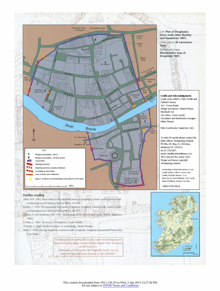
Left: Plan of Drogheda's town walls (after Buckley and Sweetman 1991). Cover picture: St Laurence's Gate.
Background ¡mage: Newoomen's map of Drogheda, 1657.
Further reading Allen, W.P. 1 943 Some notes on the old fortifications of Drogheda, County Louth. County Louth
Archaeological and Historical Journal 10 (3), 233-44.
Bradley, J. 1 978 The topography and layout of medieval Drogheda, County Louth. County Louth
Archaeological and Historical Journal 19 (2), 98-1 27.
Buckley, V. and Sweetman, P.D. 1 991 Archaeological Survey of County Louth. Dublin. Stationery Office.
D'Alton, J. 1844 The history of Drogheda (2 vols). Dublin.
O'Keeffe, T. 2000 Medieval Ireland: an archaeology. Stroud. Tempus.
Reilly, T. 1995 Tracing Drogheda's medieval walls. Drogheda. Drogheda Monuments Preservation
Committee.
2^H KEY
^^^^^^^^^^^^^^^^^^^^^^^^^^^^^^^^^^^|
fi Religious foundation, site of ^^^^^^^^^^^^^^^^^^^^^^^^^^^^^^^^^^^^^^^^^^^^^^H ■ Religious foundation, remains extant ^^^^^^^^^^^^^^^^^^^^^^^^^^^^^^^^^^^^^^^^^^^^^^H
OO Tower/Gate ^^^^^^^^^^^^^^^^^^^^^^^^^^^^^^^^^^^^^^^^| ^^^^ Standing sections ^^^^^^^^^^^^^^^^^^^^^^^^^^^^^^^^^^^^^^^^^^^^^^H " ^ # Standing sections, possibly medieval ^^^^^^^^^^^^^^^^^^^^^^^^^^^^^^^^^^^^^^^^H "#0 Foundations discernible ^^^^^^^^^^^^^^^^^^^^^^^^^^^^^^^^^^^^^^^^^^^^^^H 1HB1B Line of earlier town defences ^^^^^^^^^^^^^^^^^^^^^^^^^^^^^^^^^^^^^^^^^^^^^^H
Approx. locations of archaeological excavations of the walls ^^^^^^^^^^^^^^^^^^^^^^^^^^^^^^^^^^^^^^^^^^^^^^H
I i i i i | 250m ^^^^^^^^^^^^^^^^^^^^^^^^^^^^^^^^^^^|
Credits and Acknowledgements Guide series editors - Tom Condit and Gabriel Cooney Text- Conor Brady Design and layout- Niamh Power, Wordwell Ltd 7exi editor- Emer Condit Circulation and distribution manager- Helen Dunne
Date of publication: September 2003.
To order this guide please contact the Sales Officer, Archaeology Ireland, PO Box 69, Bray, Co. Wicklow, telephone 01 2765221, fax 01 2765207. email: [email protected] Text copyright the author 2003.
Design and layout copyright Archaeology Ireland.
Archaeology Ireland editorial team - Tom
Condit (editor), Gabriel Cooney, Emer
Condit, Nicholas Maxwell, Una
MacConville, Brian Williams, Chris Corlett,
Aidan O'Sullivan, Michael Connolly
ISSN 0790-982X
For information on joining the County Louth Archaeological and Historical Society, please contact Deirdre Russell (Hon. Secretary)
on 087-6343511. Information on joining the Old Drogheda Society may be
obtained from Millmount Museum on 041-9833097. vSÇCïp- m2ü75o I
This content downloaded from 193.1.234.19 on Wed, 3 Apr 2013 13:27:56 PMAll use subject to JSTOR Terms and Conditions