the louisiana purchase. cause: the united states purchases the louisiana territory. main...
TRANSCRIPT

The Louisiana Purchase

Cause:The United States
purchases theLouisiana Territory.
Main MenuDiagramsCICERO © 2007
History Beyond The Textbook
CICERO
Cause:The United States
purchases theLouisiana Territory.
Effect:The size of the United
States is doubled.
Main MenuDiagramsCICERO © 2007
History Beyond The Textbook
CICERO

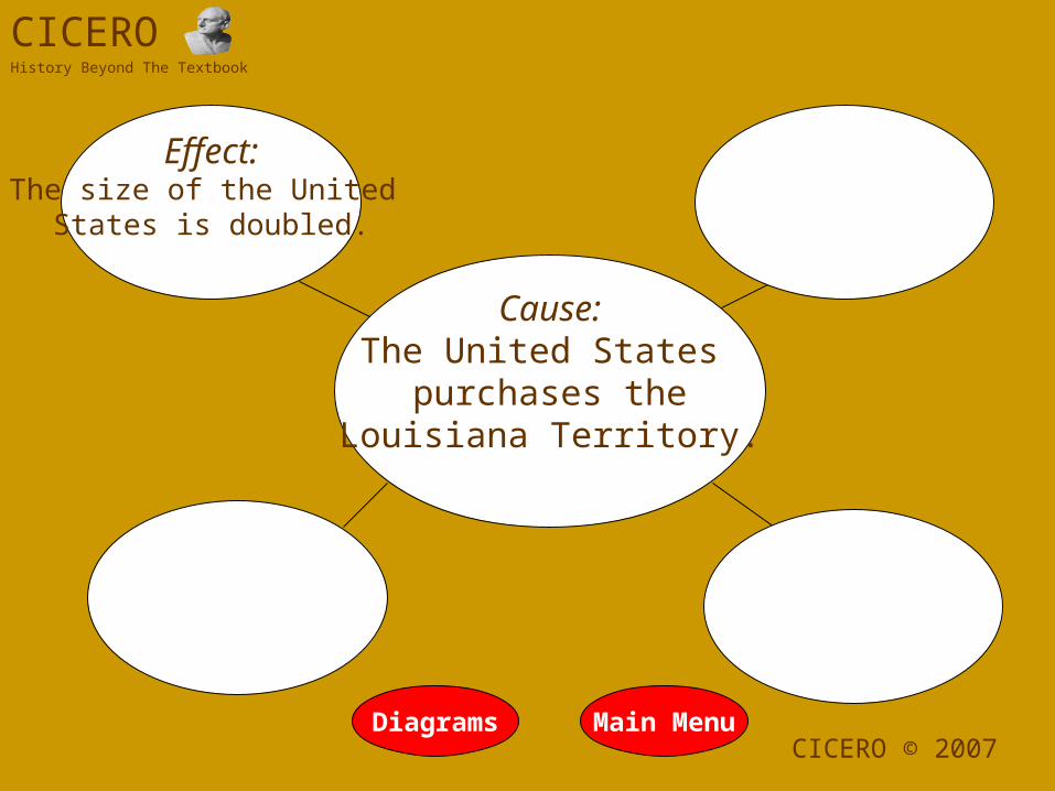
Cause: The United States
purchases theLouisiana Territory.
Effect:The size of the United
States is doubled.
Effect:The United States now
controls New Orleans and the Mississippi River.
Main MenuDiagramsCICERO © 2007
History Beyond The Textbook
CICERO

Cause: The United States
purchases theLouisiana Territory.
Effect:The size of the United
States is doubled.
Effect:The United States now
controls New Orleans and the Mississippi River.
Effect:President Jefferson sends an expedition to explore the new
territory.
Effect:Settlers looking for cheap land begin to
move westward.
Main MenuDiagramsCICERO © 2007
History Beyond The Textbook
CICERO

New Orleans• By the early 1800s the United
States stretched from the Atlantic Ocean to the Mississippi River. With overland transportation still unreliable, the Mississippi River was a vital transportation route for farmers to get their products to markets in the East. President Thomas Jefferson knew whoever controlled New Orleans, controlled the Mississippi River.
• In 1802 Jefferson sent James Monroe to France to negotiate the purchase of New Orleans for $10 million. Monroe also was sent to Spain to negotiate the purchase of the territory of Florida.
• While the French initially refused America’s offer, the French now knew the United States was interested in paying for the territory.
Thomas Jefferson
Napoleon Bonaparte
Satellite Image of New Orleans

France’s Plans Are Foiled• France planned to use its island colony
of Haiti as a base for future French settlers to move into the Louisiana Territory west of the Mississippi.
• These plans were disrupted when a slave, Toussaint L’Ouverture, led a revolt against the French. The slaves took control of the island, and France’s plans for a French base were abandoned.
• At the same time, France was fighting a war with other European countries and badly needed money.
• These events caused Napoleon to approach the Americans with the greatest land bargain of all time! He agreed to sell New Orleans and the entire Louisiana territory for $15 million. This land purchase would double the size of the United States!
• However, the French could not define the borders of the land.
Toussaint L’Ouverture
Haiti

The Corps of Discovery• Before the purchase of the
Louisiana territory was official, President Jefferson began planning to send an expedition to map the territory.
• Jefferson chose his secretary, Captain Meriwether Lewis. He and his old friend organized an expedition of thirty-one men, mostly soldiers. This Corps of Discovery headed for the unknown lands west of the Mississippi River.
• The Corps’ mission was to travel up the Missouri River in search of a northwest passage, an all-water route to the Pacific Ocean. The men were to make contact with American Indian tribes in the region.
• Contrary to popular belief, Lewis and Clark were not the first to lead an expedition to the Pacific Ocean. Alexander MacKenzie crossed to the Pacific in 1793.
Captain William Clark
1770-1838
Meriwether Lewis
1774-1809
A Newfoundland named Seaman
accompanied the Corps of Discovery.

York
• One of the men in the Corps of Discovery was York, the slave of William Clark.
• As the Corps met Indians in their journey west, York’s appearance amazed the Indians. Many Indians had never seen an African-American man and believed him to be part bear.
Many former slaves went west in search of freedom in the territories. The Indians
treated them as equals.
Indians who met York thought he was covered in paint and attempted to wipe it
off.
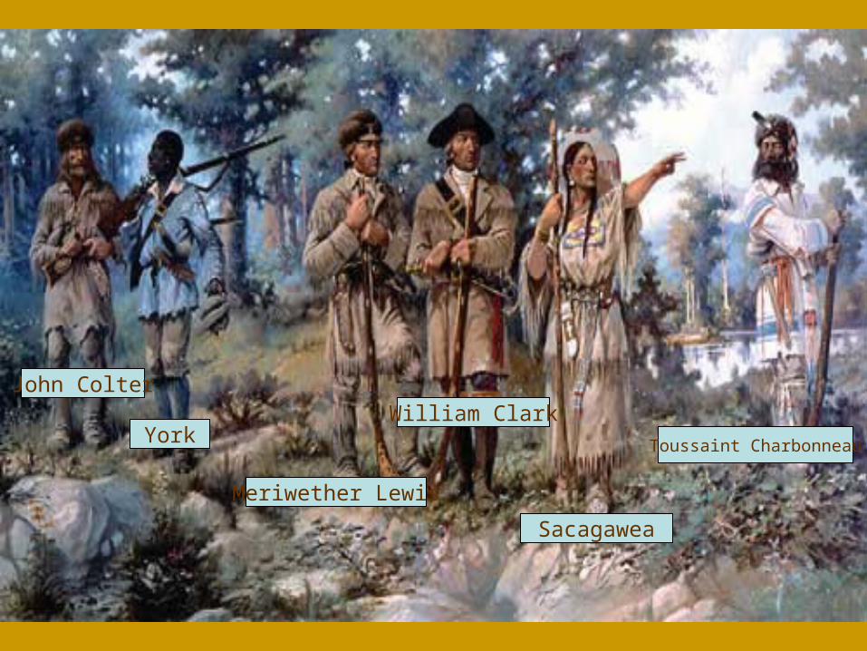
Toussaint Charbonneau
Sacagawea
Meriwether Lewis
William ClarkYork
John Colter


Training in Philadelphia
• In the spring of 1803, Meriwether Lewis made his way to Philadelphia, the scientific capital of the United States, to train for the mission. In Philadelphia he was educated in mapmaking and the sciences. Lewis spent much of his time at the museum of Charles Willson Peale located on the second floor of Independence Hall.
• Lewis also purchased scientific instruments and other supplies with the $2,500 Congress had given him to finance the expedition.
• After stopping in Pittsburgh to oversee the building of the keelboat, Lewis joined Clark at the Corps’ winter camp in Illinois.
The shop of Israel Whelan, Purveyor of Public Supplies. Lewis bought
many of his supplies here.
The Peale museum was located on the second floor of Independence Hall.
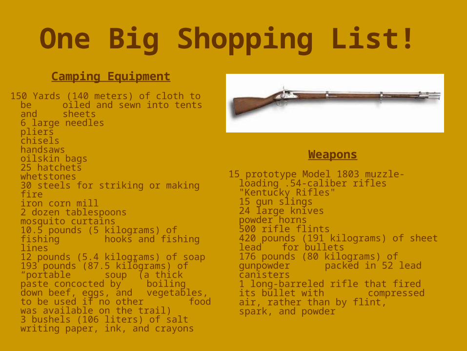
One Big Shopping List!
150 Yards (140 meters) of cloth to be oiled and sewn into tents and sheets 6 large needlespliers chisels handsawsoilskin bags 25 hatchets whetstones30 steels for striking or making fire iron corn mill 2 dozen tablespoons mosquito curtains 10.5 pounds (5 kilograms) of fishing hooks and fishing lines 12 pounds (5.4 kilograms) of soap 193 pounds (87.5 kilograms) of “portable
soup” (a thick paste concocted by boiling down beef, eggs, and vegetables, to be used if no other food was available on the trail) 3 bushels (106 liters) of salt writing paper, ink, and crayons
15 prototype Model 1803 muzzle-loading .54-caliber rifles "Kentucky Rifles"15 gun slings24 large knivespowder horns 500 rifle flints420 pounds (191 kilograms) of sheet lead
for bullets 176 pounds (80 kilograms) of gunpowder
packed in 52 lead canisters 1 long-barreled rifle that fired its bullet with
compressed air, rather than by flint, spark, and powder
Camping Equipment
Weapons

More Supplies ...
12 dozen pocket mirrors 4,600 sewing needles 144 small scissors 10 pounds of sewing thread silk ribbonsivory combs handkerchiefs yards of bright-colored cloth 130 rolls of tobacco tomahawks that doubled as pipes 288 knives 8 brass kettles vermilion face paint 20 pounds of assorted beads, mostly blue5 pounds of small, white, glass beads288 brass thimblesarmbandsear trinkets
45 flannel shirts 20 coats 15 frocks shoes woolen pants 15 blankets knapsacks 30 stockings 15 pairs of wool overalls
Presents for American Indians
Clothing
50 dozen Dr. Rush's patented "Rush's Thunderclapper" pills lancets forceps syringes tourniquets 1,300 doses of physic 1,100 doses of emetic 3,500 doses of diaphoretic (sweat inducer) additional drugs
Medicine

Transportation• The primary means of
transportation west was a large keel boat and two smaller open boats. Lewis also brought a collapsible boat he had designed. However, by the time the expedition needed the boats, there were no pine trees to make pitch (tar from burned pine trees), used to water-proof boats.
• The Corps hoped at some point they would be able to trade with native people for horses.
swivel gunThe keelboat was fifty-five feet long.
Securing horses as they traveled was vital to completing the Corps’
mission.

Starting Out
• On May 20, 1804, the Corps of Discovery left St. Louis on their journey up the Missouri River.
• The group traveled more than six hundred miles up the Missouri before meeting a single American Indian.
• On August 2, the Corps had their first encounter with Indians when they met members of the Oto and Missouri tribes. The tribes warned the Corps of the powerful Teton-Sioux that lived farther up the Missouri. The group would soon learn why the Sioux earned the nickname, Pirates of the Missouri.
Mississippi River
Missouri River
St. Louis (Missouri)
Camp Wood (Illinois)
Satellite image of the Mississippi and Missouri Rivers
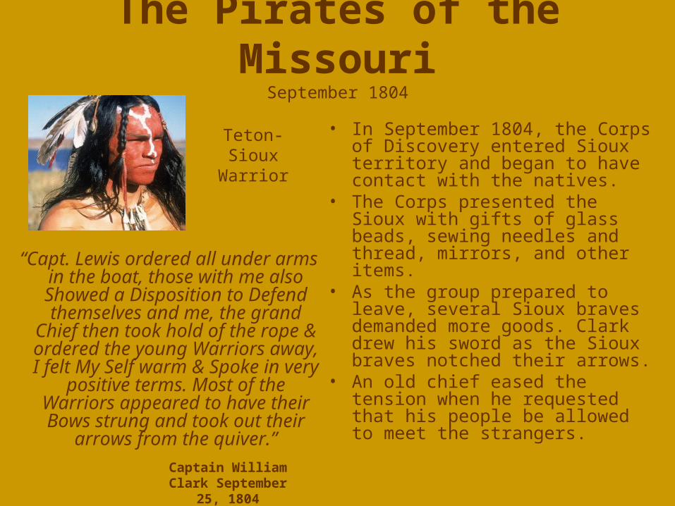
The Pirates of the MissouriSeptember 1804
“Capt. Lewis ordered all under arms in the boat, those with me also
Showed a Disposition to Defend themselves and me, the grand
Chief then took hold of the rope & ordered the young Warriors away,
I felt My Self warm & Spoke in very positive terms. Most of the Warriors appeared to have their Bows strung and took out their
arrows from the quiver.”
• In September 1804, the Corps of Discovery entered Sioux territory and began to have contact with the natives.
• The Corps presented the Sioux with gifts of glass beads, sewing needles and thread, mirrors, and other items.
• As the group prepared to leave, several Sioux braves demanded more goods. Clark drew his sword as the Sioux braves notched their arrows.
• An old chief eased the tension when he requested that his people be allowed to meet the strangers.
Captain William Clark September 25, 1804
Teton-Sioux
Warrior

A Whole New World• One of the missions
assigned to the Corps was to record the discovery of new plants and animals. They also hoped to bring some animals back for further study.
• Throughout their 8,000- mile journey, the group would discover one hundred seventy-eight plants and one hundred twenty-two species and sub-species of animals.
When members of the Corps first saw a
grizzly bear, they decided to shoot it. This angered the
bear, and the bear charged the men.
The men used soapy water to flush the
black–tailed prairie dog out of its burrow. It was the only animal
that survived the return journey to
Washington, D.C.
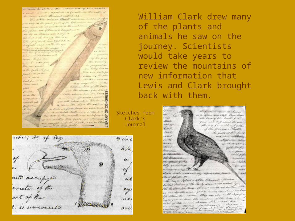
William Clark drew many of the plants and animals he saw on the journey. Scientists would take years to review the mountains of new information that Lewis and Clark brought back with them.
Sketches from Clark’s Journal

Fort MandanWinter Quarters 1804-1805
• The Corps reached what is today Bismarck, North Dakota, in October 1804 and began constructing their winter quarters.
• This was the traditional homeland of the Mandan and Hidatsa Indians who lived off the plains buffalo.
• It was here that the Corps would hire Toussaint Charbonneau and his young wife, Sacagawea, to guide them west.
• On February 11, 1805, Sacagawea gave birth to a son with the help of Meriwether Lewis. She named her son Jean-Baptiste. The members of the Corps nicknamed him Pompy, or “little dancer.” Pompy became the youngest member of the Corps.
View from the Front Gates of a Replica of Fort Mandan.
In 1804 millions of buffalo still roamed the plains of the Midwest. Today only small herds exist in national parks such as Yellowstone.
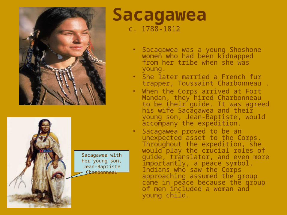
Sacagawea c. 1788-1812
• Sacagawea was a young Shoshone women who had been kidnapped from her tribe when she was young.
• She later married a French fur trapper, Toussaint Charbonneau .
• When the Corps arrived at Fort Mandan, they hired Charbonneau to be their guide. It was agreed his wife Sacagawea and their young son, Jean-Baptiste, would accompany the expedition.
• Sacagawea proved to be an unexpected asset to the Corps. Throughout the expedition, she would play the crucial roles of guide, translator, and even more importantly, a peace symbol. Indians who saw the Corps approaching assumed the group came in peace because the group of men included a woman and young child.
Sacagawea with her young son, Jean-
Baptiste Charbonneau

The Source of the MissouriAugust 12, 1805
• As the group traveled up the Missouri, they were unable to continue in their boats. They could also see the snow-capped mountains ahead.
• At this point the Corps realized a northwest passage did not exist.
• To make things worse, one of the open boats capsized, spilling supplies and parts of Clark’s journal into the river. Sacagawea stayed calm and saved many of the papers.
• At this point the group had to find Indian tribes to trade for horses or they would run the risk of being caught in the Rockies during the winter.
Source of the Missouri River
The expedition had been told that they only had to cross a small range of mountains. They were astounded to discover the true
size of the Rockies.

Sacagawea Saves the Day• On August 17, 1805, the Corps
reached a Shoshone village at the foot of the Rocky Mountains, and they began to trade for horses.
• During this initial meeting, Sacagawea realized the Shoshone chief, Cameahwait, was her long-lost brother. This was the same tribe from which Sacagawea had been kidnapped many years before!
• Needless to say, the Shoshone provided the Corps with the horses they needed and even sent guides to help the expedition through the Bitterroot Range of the Rocky Mountains.
Sacagawea began to weep when she recognized her brother. The translation at this meeting was very complicated. It involved Sacagawea translating the Shoshone language into Mandan and Charbonneau translating the Mandan into French. Another member of the Corps would translate the French into English.

The Fastest People on Earth!!
• On September 23, 1805, the Corps reached the other side of the Rockies.
• When the Corps reached the Columbia River, on the present-day Washington-Oregon border, they built canoes and began to float down the river with the current.
• As they made their way down the swiftly moving river, they were traveling faster than any other people on Earth.
• The Columbia did have many treacherous rapids that threatened the group several times. At some points the Corps was forced to carry its canoes and supplies around steep rapids and falls.
Rapids on the Columbia River
The name Nez Perce was mistakenly given to the group even though they
did not pierce their noses.

“Ocean in View! O! The Joy!”William Clark, November 7, 1805
• The expedition reached the Pacific Ocean in November 1805. They immediately began to look for a ship to carry copies of the records of the Corps’ discoveries back to Washington, D.C.
• At the mouth of the Columbia River, the group began to build its winter quarters.
• When Clark wrote the words, “Ocean in view! O! The Joy!” he believed he had seen the Pacific Ocean. However, he was just seeing the widening of the Columbia River. It would take another two weeks to reach the ocean.
View of the Pacific Ocean
The Nez Perce taught the Corps how to make dugout canoes.
The Corps of Discovery
What were the results of Lewis and Clark’s exploration of the Louisiana Territory?
Main MenuDiagrams CICERO © 2007
CICEROHistory Beyond The Textbook
What were the results of Lewis and Clark’s exploration of the Louisiana Territory?
Lewis and Clark returnwith detailed maps and information about new
plants and animals.
Main MenuDiagrams CICERO © 2007
History Beyond The Textbook
CICERO
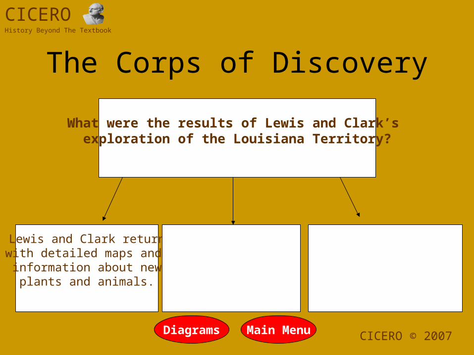
The Corps of Discovery

What were the results of Lewis and Clark’s exploration of the Louisiana Territory?
Lewis and Clark returnwith detailed maps and information about new
plants and animals.
The expedition allowed the United States to claim the Oregon
Territory.
Main MenuDiagramsCICERO © 2007
History Beyond The Textbook
CICERO
The Corps of Discovery

What were the results of Lewis and Clark’s exploration of the Louisiana Territory?
Lewis and Clark returnwith detailed maps and information about new
plants and animals.
The expedition allowed the United States to claim the Oregon
Territory.
The Corps of Discovery established peaceful
relations with many of theIndian tribes they
encountered.
Main MenuDiagrams CICERO © 2007
History Beyond The Textbook
CICERO
The Corps of Discovery

Fort ClatsopWinter 1805-1806
• Shortly after their arrival at the Pacific Ocean, Lewis and Clark held a vote among the Corps to decide where to build their camp.
• Both Sacagawea and York were allowed to vote. This demonstration of America’s democratic values would not be repeated for more than a hundred years.
• The Corps decided to build its winter quarters near the Clatsop people who lived by fishing the abundant salmon that migrated up the Columbia every year. The Corps named their fort in honor of the Clatsop.
Replica of Fort Clatsop
Salmon Drying on Racks

Conflict with the Blackfoot
• On their return to St. Louis, the Corps decided to split up in order to map more territory. One group met a pair of Blackfoot Indians who attempted to steal their horses early the next morning.
• In the altercation that followed, one Indian was shot; and the other stabbed to death.
• The members of the Corps laid the peace medals they brought with them on the dead Blackfoot Indians to send a warning to the Indians.
• The Blackfoot people were not frightened. They attacked future settlers and soldiers that entered their territory. They pointed to the killing of their warriors as the reason for their attacks.
Blackfoot Indian
Peace medal placed on dead
Blackfoot Indians

Hell on Earth!• One of the members of the Corps,
John Colter, split from the group and stumbled into the Yellowstone Valley. Colter was the first European to see the Yellowstone geysers.
• Lewis did not believe the stories Colter told him about what he had seen in the Yellowstone Valley. In fact, other members of the expedition and people in St. Louis made fun of him when he returned to St. Louis with what seemed to be outlandish tales of what he had seen. Until the claims were proven correct, the area was known sarcastically as Colter’s Hell.
• Yellowstone became America’s first national park in 1872 when Congress passed the legislation, and President Ulysses Grant signed it into law.
Mountain man Jim Bridger also traveled through the Yellowstone Valley. When he told
people of this place, few believed the stories of his experiences.

Back in St. LouisSeptember 23, 1806
• When the Corps of Discovery returned to St. Louis more than two years after it had left, the Corps was greeted with cannon fire and hailed as heroes.
• Many Americans, including Thomas Jefferson, had given up hope of the Corps returning alive.
• When Jefferson finally received the maps the expedition had prepared, he is reported to have spread them on the floor and studied the maps for days.
Re-enactors play the roles of Lewis, Clark, Colter, and even Seaman
during the bicentennial celebration of Lewis and Clark’s journey.
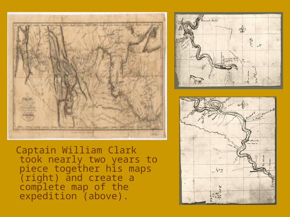
Captain William Clark took nearly two years to piece together his maps (right) and create a complete map of the expedition (above).

The Legacy• The Louisiana Purchase doubled the size of
the United States. The United States paid France $15 million for the Louisiana Territory. When the final calculations were done, this vast tract of land cost about four cents and acre!
• The final cost of the Lewis and Clark Expedition was $39,000, which was substantially more than the $2,500 Congress had authorized.
• Only one man died on the journey, and he appeared to have succumbed to an appendicitis.
• Students often ask what happened to Jean-Baptiste, Sacagawea’s son. He grew up, traveled to Europe, and returned to America. He made his fortune as a forty-niner during the California Gold Rush.
St. Louis Arch “Gateway to the West”

Legacy cont.
• Sacagawea became only the second American woman to be honored on American currency. In 2000 she and her son’s likenesses were engraved on a new $1 coin.
• Sadly, Sacagawea died of an unknown illness in 1812. William Clark took responsibility for raising Jean-Baptiste and Lisette.
Sacagawea Dollar – 2001
