the lithostratigraphy of the shales with -b eef member of
TRANSCRIPT

R.W. Gallois
32
THE LITHOSTRATIGRAPHY OF THE SHALES-WITH-BEEF MEMBER
OF THE CHARMOUTH MUDSTONE FORMATION, LOWER JURASSIC
R.W. GALLOIS
INTRODUCTION
The wholly exposed, richly fossiliferous Lower Jurassicsuccession exposed in the cliffs between the Axe Valley in eastDevon and Seatown in west Dorset has attracted geologists andfossil collectors for over 200 years. The contributions to theearly development of the earth sciences made by fossilcollectors such as Mary Anning and the Philpot sisters, and bylocal geologists Henry de la Beche, William Buckland andWilliam Conybeare, have been well documented. They wereinstrumental in changing the study of the physical andbiological history of the Earth from one based on a literalreading of the Bible to one based on observation andhypothesis. Buckland’s (1829) discovery of the “the faeces ofthe Ichthyosaurus” in the Lias at Lyme Regis was a turning pointthat was to lead on to the theory of evolution and areassessment of the age of the Earth.De la Beche (1826), using the nomenclature of William
Smith’s (1815) geological map of England and Wales, describedthe Jurassic succession exposed in the coastal sections aroundLyme Regis as Blue Lias overlain by c. 36 m of fossiliferous‘slaty marls’ with thin beds of indurated marl, nodularconcretions and selenite crystals. He subsequently (Bucklandand De la Beche, 1836) referred to the thin seams of fibrouscalcite that are common in the lower part of the succession as‘beef’, a term adopted from quarrymen working the PurbeckBeds in west Dorset (Challinor, 1961).The first detailed description of the beds that overlie the Blue
Lias was that of Woodward (1893) under the name Black VenBeds: this was repeated and expanded on in Woodward and
Gallois, R.W. 2008. The lithostratigraphy of the Shales-with-Beef Member of the Charmouth Mudstone Formation, LowerJurassic. Geoscience in South-West England, 12, 32-40.
The Shales-with-Beef Member of the Charmouth Mudstone Formation (Lower Jurassic) crops out in almost continuous cliff andforeshore sections over a distance of c. 5 km between Pinhay Bay, east Devon and Charmouth, west Dorset. A fault-boundedoutlier, 3.5 km west of Pinhay Bay, exposes the lower part of the member. At its type section on the foreshore and in cliffs belowBlack Ven, Charmouth, the member consists of c. 30 m of thinly interbedded organic-rich mudstones and calcareous mudstoneswith numerous thin beds of fibrous calcite (‘beef’) and several beds of tabular and nodular limestone. Many of the individual bedsof mudstone are richly fossiliferous and this has previously been used, in combination with the lithological variations, to dividethe succession into over 100 numbered and lettered beds. However, as noted in the original study, many of the thinner beds arelaterally impersistent and few can be recognised with confidence away from the type section. In addition, the type section isseparated from the main Shales-with-Beef Member outcrop in the Lyme Regis area by a penecontemporaneously active fault beltthat had an effect on sedimentation. Other fault belts at Lyme Regis and westwards from there divide the outcrop into areas withsuccessions that differ in detail from the type section and from one another. As a result, few of the numbered beds can be tracedfrom one of these areas into the adjacent area. A simplified system of bed numbering is described here based on sections that cropout on the west and east sides of Lyme Regis, supplemented by the successions proved in cored site-investigation boreholes drilledat Lyme Regis. The proposed lithostratigraphy provides a framework that takes account of the lateral variations in the member overits full outcrop distance, and enables material collected from any part of the exposure to be placed in its correct stratigraphicalcontext.
92 Stoke Valley Road, Exeter, EX4 5ER, U.K.(E-mail: [email protected]).
Keywords: Charmouth Mudstone Formation, lithostratigraphy, Lower Jurassic, Devon, Dorset.
Ussher (1911). It included most of the named marker beds oflater descriptions, in particular Table Ledge at the base of thesuccession and the Birchi Tabular Bed in the middle part.Woodward (1893), working on the exposures adjacent to LymeRegis, divided the succession between these two marker bedsinto nine units in which five limestones (0.1 to 0.3 m thick)were separated by mudstones (3 to 7.5 m thick). Lang (1914)introduced the name Shales-with-‘beef’ for this part of thesuccession which he described as “paper-shales, marls, induratedbands, and limestone nodule-beds, with numerous, more orless impersistent, interbedded seams of fibrous calcite”. In theformalised nomenclature of the Lias Group (Cox et al., 1999) theShales-with-Beef is now the basal member of the CharmouthMudstone Formation (formerly the Lower Lias Clay). The base ofthe formation is defined as the top of the youngest limestone in amudstone succession that contains numerous limestone beds.At Lyme Regis, the junction is taken (following Hallam, 1960) atan erosion surface at the top of a limestone bed (Grey Ledge)that marks a sudden upward change from a succession ofmudstones with numerous limestone beds (c. 40% by volume)to mudstones with few (<5% by volume) limestones.Lang et al. (1923) used the cliff and foreshore reefs [SY 357
930 to 362 930] immediately west of Charmouth to producedetailed bed-by-bed descriptions of the lithologies andammonite assemblages of the Shales-with-Beef. With theexception of specimens collected from a few cemented beds,the ammonites are crushed and difficult to extract from thecliffs, and the reefs in the intertidal area are the most accessible

The lithostratigraphy of the Shales-with-Beef Member of the Charmouth Mudstone Formation
33
sections for palaeontological collecting. Lang et al. (1923)divided the Shales-with-Beef succession at Charmouth into 23beds (numbers 53 to 75) commencing with Table Ledge andfollowing on from Lang’s (1924) numbering of the Blue Lias.The 23 beds were further divided into over 100 subsidiary beds,many less than 50 mm thick (Figure 2). Some of these arelaterally discontinuous beds of beef, others are characterised byone or more crushed layers of a particular ammonite. Langhimself noted (in Lang et al., 1923) that “it is not to be supposedthat the minute subdivisions will be found farther along thecliff, or even that the prominent beds at the Charmouth end ofthe section will necessarily persist as far as Lyme”. This hasproved to be the case, but it does not detract from the value ofLang’s account which remains a fine example of detailedlithological description and faunal collecting.
GEOLOGICAL STRUCTURE
The post-Variscan evolution of southern Britain and theadjacent offshore areas was predominantly influenced by threetectonic events. Thermal relaxation and stretching of thethickened continental crust beneath the Variscan fold belts,thermal uplift and stretching related to the opening of theAtlantic Ocean, and the Cimmerian and Alpine compressionalphases. The early Jurassic in southern England was atectonically quiet period as evidenced by the deposition oflithologically similar, relatively shallow-water, marine-shelfmuds over very large areas. There are, however, minorvariations in the successions at any one stratigraphical level thatare indicative of differences in subsidence rates over short(<100 m) distances. In the Shales-with-Beef Member in theLyme Regis-Charmouth area, the principal changes occur acrosstwo well-defined structures, the Lim Valley and Black Ven fault
zones (Figure 3). In the early Jurassic these may have beensingle faults which subsequently acted as foci for folding andfurther faulting in the early Cretaceous and Miocene.In 1995, West Dorset District Council (WDDC) initiated
long-term engineering, geological and geomorphologicalstudies of the onshore and nearshore areas at, and adjacent to,Lyme Regis in advance of landslip remediation and coastaldefence works. They included aerial photography of the cliffand intertidal areas; bathymetric, seismic-reflection andsidescan-sonar surveys of the subtidal area fronting andadjacent to the town; trial pits and continuously coredboreholes; and ground and LiDaR surveys of the landslippedareas west and east of the town (Gallois and Davis, 2001). Thestratigraphy of the Shales-with-Beef Member was of particularengineering interest because the member was known to containmore than one weak mudstone bed that had given rise to majorslope failures.The combined results of these surveys showed that the
tectonic structure of the area was more complex thanpreviously known, that there were lateral variations in theShales-with-Beef Member that had not been recorded, and thatthe more significant of these variations were related to twoprincipal fault belts. These fault belts divide the outcrop intothree parts: between Pinhay Bay and the River Lim, betweenthe River Lim and the western edge of Black Ven, and betweenBlack Ven and Charmouth (Figure 1). Parts of the Shales-with-Beef Member are exposed from time to time west of PinhayBay at the foot of the Undercliffs Landslip, but the successionthere is incompletely known and is not discussed here.In the area between Pinhay Bay and the River Lim, the full
thickness of the Shales-with-Beef Member is exposed in thecliffs between Seven Rock Point [SY 329 909] and MonmouthBeach [SY 332 915], and can be measured in the cliffs below
Figure 1. Sketch map of the coastal outcrop of the Lias Group in the Lyme Regis-Charmouth area.
R.W. Gallois
34
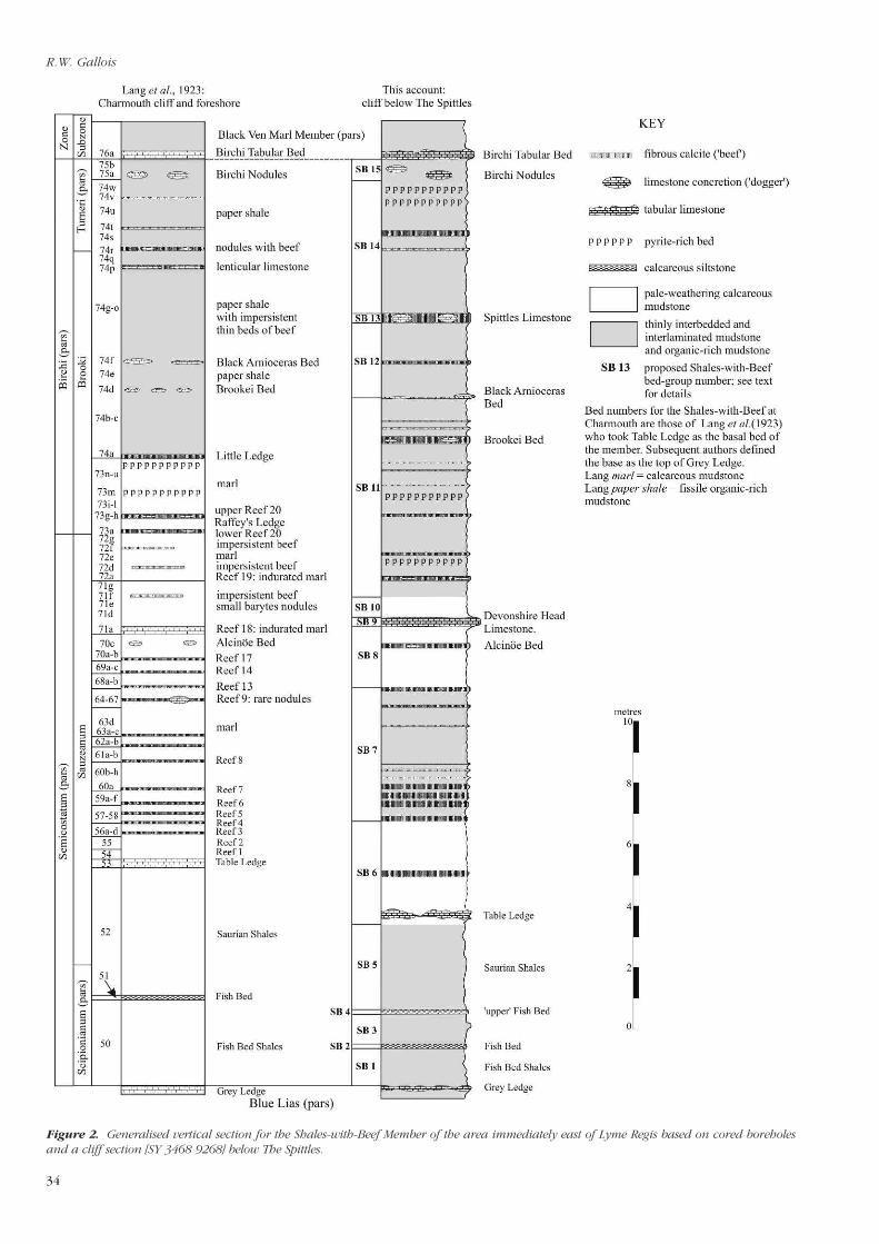
Figure 2. Generalised vertical section for the Shales-with-Beef Member of the area immediately east of Lyme Regis based on cored boreholesand a cliff section [SY 3468 9268] below The Spittles.

The lithostratigraphy of the Shales-with-Beef Member of the Charmouth Mudstone Formation
35
Devonshire Head. The more strongly cemented beds up to andincluding the level of Table Ledge crop out in the intertidalareas at Monmouth Beach [SY 337 914] and on Lyme Regisforeshore. Contrary to Palmer’s (1984) statement thatWoodward (1893) and subsequent authors had incorrectlyinterpreted the Lias outcrops at Lyme Regis, and his assertionthat the “Birchi Beds do not descend to beach level anywherebetween Pinhay Bay and Charmouth”, the Birchi Nodules andBirchi Tabular Bed crop out in the Cobb Syncline in theintertidal area adjacent to the outer wall of The Cobb.The full thickness of the member is exposed east of Lyme
Regis in the area between East Cliff [SY 346 925] and thewestern edge of Black Ven [SY 357 931]. The lower beds andthe junction with the Blue Lias are patchily exposed in ChurchCliffs, and the succession between the Blue Lias and theDevonshire Head Limestone is exposed in East Cliff, but isdifficult to access. Eastwards from there, Table Ledge and theremainder of the member are well exposed in accessiblesections below The Spittles, and the Fish Bed and Table Ledgeare exposed in the intertidal area in, and adjacent to, the faultzone. The highest bed exposed in the Newfoundland reef, theBirchi Tabular Bed, is occasionally exposed at unusually lowtides. The structure named here as the Newfoundland Syncline,is well displayed on aerial photographs taken when the sea iscalm and clear (Figure 4).In the area between Black Ven and Charmouth, east of the
Black Ven fault zone, a low easterly dip brings the memberdown to beach level between Bar Ledges [SY 358 930] and theoutfall of the River Char [SY 364 930] where there are extensiveoutcrops in the intertidal area, albeit broken by faults andcovered by variable amounts of beach deposits. The middle andupper parts of the Shales-with Beef Member are exposed in theadjacent cliff. Taken together the cliff and foreshore exposuresare the type section of Lang et al. (1923). Because of thedifficulty of bed-by-bed collecting in the Shales-with-BeefMember, the ammonite biostratigraphy is still poorly knownoutside the Charmouth foreshore section. Ammonites indicativeof the zones and subzones, and some of the biohorizonswithin them, have been recorded in fallen blocks andlandslipped material west of the Charmouth section (Page, 2002).
LATERAL VARIATIONS IN THE SUCCESSION
At outcrop in the Lyme Regis-Charmouth coastal area theShales-with-Beef Member comprises 28 to 30 m of thinlybedded medium and dark grey mudstones, pale weathering,blocky calcareous mudstones and thinly bedded and laminatedbrownish grey organic-rich (‘bituminous’) mudstones withrelatively common bedding-parallel, thin (mostly <100 mmthick) beds of fibrous calcite (‘beef’), a few beds of nodular andtabular limestone, and laterally impersistent beds withseparation concretions (Figure 5a). The lower part of themember is more calcareous overall and contains a greaternumber of laterally persistent marker beds. The upper partconsists largely of thinly interbedded mudstones and fissileweathering organic-rich mudstones (Figure 5b) with fewlithologically distinctive beds (Figure 2).The base of the member rests on a prominent bioturbated
erosion surface that caps the highest limestone (Grey Ledge) ofthe Blue Lias throughout the full length of the outcrop. Withinthe member the most laterally persistent prominent markerbeds are the Fish Bed (a laminated calcareous siltstone), TableLedge (lenses of very pale, muddy limestone with nests ofrhynchonellid brachiopods), the Devonshire Head and theSpittles limestones (tabular, lenticular and nodular limestones)and the Birchi Nodules (septarian concretions). TheShales-with-Beef is capped by the Birchi Tabular Bed, which isalso present throughout the outcrop. Taken together these bedsform a stratigraphical framework that can be traced throughoutthe onshore and nearshore areas between Lyme Regis andCharmouth. Grey Ledge, the Devonshire Head and the Spittleslimestones and the Birchi Tabular Bed give rise to strongreflections in offshore seismic-reflection surveys and they cropout as prominent reefs on the sea bed (Gallois and Davis, 2001,figures 4 and 5). The limestones give rise to prominent lows inthe total-gamma-ray logs in boreholes. In the middle and upperparts of the member, the fossiliferous Alcinöe Bed, withnumerous crushed Paranioceras alcinoë, and the BlackArnioceras Bed, a storm-deposit crowded with jumbled upArnioceras at all stages of development from eggs to maturity(Figures 5c and 5d), are laterally impersistent micrites that
Figure 3. Geological sketch map of the Shales-with-Beef outcrop in the onshore and nearshore area between Lyme Regis and Charmouth.

R.W. Gallois
36
provide supplementary marker beds between Lyme Regis andCharmouth but are weakly developed west of Lyme Regis.Lang (in Lang et al., 1923) recorded the thickness of the beds
between Table Ledge and the Birchi Tabular Bed in the cliff andforeshore at Charmouth as 22 m. This has proved to beremarkably accurate given the difficulty of making thicknessmeasurements in sub-vertical cliffs and gently dipping foreshoreoutcrops. Hesselbo and Jenkyns (1995) measured the samebeds in the same section to be 33 m thick. Initial attempts tomeasure the thicknesses of the Charmouth Mudstone membersin the principal exposures between Lyme Regis and Black Venproved to be so different (up to 20% at some stratigraphicallevels) from those proved in cored boreholes that the outcropswere re-measured using an electronic theodolite. The outcropthicknesses quoted here were made in collaboration withMr Geoff Davis and Mr Henry Middleton of WDDC.Measurements made in the best exposed and most easily
accessible sections in the Shales-with-Beef Member, those in thecliffs below The Spittles, proved a broadly similar succession oflithologies and thicknesses to that described by Lang et al.(1923) at Charmouth. However, two of the most prominentlaterally persistent beds below The Spittles, the DevonshireHead and Spittles limestones, are absent at Charmouth. Whentraced across the Black Ven fault zone the Devonshire HeadLimestone might be the correlative of Lang’s “indurated marl”(Bed 71a).The thicknesses of the successions measured below The
Spittles and at Charmouth during the present survey wereroughly similar. In contrast, those recorded to the west of LymeRegis in the Devonshire Head area were up to 3 m less, withmuch of the difference concentrated in the beds between Table
Ledge and the Devonshire Head Limestone. Two patterns ofsite-investigation boreholes drilled on the west and east sides ofthe River Lim confirmed that this difference was not ameasuring artefact and was related to the Lim Valley fault zone(Figure 6). In the boreholes east of the river (WDDC 80 and200 series) the distance between the top of Grey Ledge and theDevonshire Head Limestone was 14.4 ± 0.1 m. In those west ofthe river (WDDC 90 series) it was 12.1 ± 0.1 m. The changeoccurs within an east-west distance of less than 50 m across thefault belt (Figure 6).Comparison of the lateral variations in the lower part of the
Shales-with-Beef Member in and adjacent to Lyme Regis showsthat the variations in thickness are related to sedimentary breaksin the succession that are marked by sudden changes inlithology (Figure 6). The most prominent of these appears tooccur at the top of the Devonshire Head Limestone (Figure 7)which is locally capped by concentrations of phosphaticnodules. There is little lateral variation in thickness in the bedsbetween the Devonshire Head Limestone and the BirchiTabular Bed in the Lyme Regis-Charmouth area.
REVISED BED-NUMBERING SYSTEM
The simplified classification proposed here is based on therecognition of marker beds that are present throughout most ofthe coastal outcrop. Some of these can be correlated with theCharmouth foreshore ‘type section’ and enable the detailedammonite-based biostratigraphy recorded by Lang et al. (1923)to be related to the Shales-with-Beef successions exposed in themain outcrop. In the following summary beds SB 1 to SB 15
Figure 4. Aerial view of the Newfoundland submerged reef and the syncline on the north side of the Black Ven fault zone. See Figure 3 forabbreviations of the principal marker beds in the Shales-with-Beef Member. Part of West Dorset District Council Frame J2334, 17th September,2001.

The lithostratigraphy of the Shales-with-Beef Member of the Charmouth Mudstone Formation
37
Figure 5. Examples of Shales-with-Beef lithologies. (a) Septarian concretion, Bed SB 8, excavation in Lister Gardens, Lyme Regis. This andsimilar nodules were watertight but water filled when freshly excavated. They appear to have nucleated around a bed of partially phosphatisedammonites at about the level of the Alcinoë Bed. (b) Bituminous mudstones with fissile ‘curly’ weathering, basal Bed SB 11, Devonshire Head.This type of weathering is typical of the more organic-rich parts of the member. On sunny days these beds smell strongly of hydrocarbons.(c) Lenticular slab of shelly Black Arnioceras Bed limestone, cliff below The Spittles. Loose blocks of this bed are common on the outcrop east ofthe River Lim, but are rare westwards from there. (d) Thin section of the Black Arnioceras Bed viewed in transmitted light. The bed iscrowded with ammonites at all stages of maturity from eggs (<0.1 mm diameter) and post-embryonic forms (insert) to mature specimens>40 mm in diameter. They lie at all angles to the bedding and probably represent a shallow-water life assemblage that was swept into deeperwater during a storm.
(Figure 2) comprise a combination of laterally persistentmarker beds and groups of intervening beds. Over the shortdistance of the coastal outcrop the bed groups approximate tochronostratigraphical units.
Black Ven Marl Member (pars): almost continuous tabular,dense muddy limestone (Birchi Tabular Bed) (0.15 to 0.30 m).
Bed SB 15: thinly interbedded dark grey mudstones andlaminated brownish grey organic-rich mudstones with severalthin (<10 mm thick) beds of beef; one, locally two, lines ofseptarian nodules 1 to 2 m apart in the lower part of the bed;mostly ellipsoids up to 0.3 m diameter and 0.2 m thick, someenclosing Microderoceras birchi (Birchi Nodules) (0.30 to 1.10 m).
Bed SB 14: thinly interbedded grey mudstones and organic-richmudstones as above with 3-4 thin (<10 mm thick) beds of beefand several pyritised beds up to 10 mm thick (3.30 to 4.30 m).
Bed SB 13: tabular densely cemented muddy limestone (SpittlesLimestone) passing locally in the eastern part of the outcropinto muddy limestone septaria coated with beef, or into a thickmultiple layer of beef (0.20 to 0.35 m).
Bed SB 12: thinly interbedded mudstones and organic-richmudstones as above with several thin (<10 mm thick) beds ofbeef; base taken at base of discontinuous lenses of limestoneup to 0.12 m thick and 0.6 m long, mostly crowded withArnioceras, but locally barren (Black Arnioceras Bed); pyriticbasal bed gives rise to ferruginous seepages; limestone lenseswidely spaced (>20 m) west of Lyme Regis (2.30 to 2.50 m).
Bed SB 11: laminated organic-rich mudstones with thininterbeds of dark grey mudstone; prominent beef seam in toppart of bed east of Lyme Regis with widely spaced, small (up to0.1 m across) septarian nodules with Arietities brookei (BrookeiBed); fissile organic-rich bed (0.4 m thick) at base rests withsharp lithological contrast and possible erosion on bed below(5.00 to 6.50 m).
Bed SB 10: calcareous mudstone, weathering to pale and verypale grey; widely spaced (2 to 3 m) small very pale-weatheringconcretions; highest 80 mm locally very pale grey withcream-coloured phosphatic nodules indicative of condenseddeposition (0.50 to 0.70 m).
Bed SB 9: tabular densely cemented muddy limestone capped

R.W. Gallois
38
by 20 to 30 mm thick layer of beef (Devonshire HeadLimestone) (0.25 to 0.30 m).
Bed SB 8: calcareous mudstone weathering pale and very palegrey; prominent very pale grey calcareous mudstone in middlepart of bed locally contains widely spaced, ovoid calcareousconcretions with Pararnioceras alcinoë (Alcinoë Bed) andseptarian nodules (0.90 to 2.00 m).
Bed SB 7: thinly bedded medium and dark grey mudstones withthin interbeds of organic-rich mudstone and numerous thin(<10 mm thick) beds of beef; distinct colour contrast at base(2.10 to 4.40 m).
Bed SB 6: calcareous mudstones weathering to pale and verypale grey, with an almost continuous, patchily cementedmuddy limestone in the lower part (Table Ledge, 0.15 to 0.4 mthick) with nests of iridescent rhynchonellid brachiopods (1.80to 3.20 m).
Bed SB 5: thinly bedded medium and dark grey mudstones withthin interbeds of organic-rich mudstones (Saurian Shales) (2.50to 3.80 m).
Bed SB 4: tabular, calcareously cemented, bioturbated siltstone(‘upper’ Fish Bed) (0.10 to 0.15 m).
Bed SB 3: thinly bedded medium and dark grey mudstones withthin interbeds of organic-rich mudstones (Fish Bed Shales) (1.00to 1.30 m).
Bed SB 2: tabular, calcareously cemented, strikingly laminatedsiltstone (Fish Bed) (0.15 to 0.20 m).
Figure 6. Correlations based on total-gamma-ray logs between the Shales-with-Beef successions proved in boreholes in Lyme Regis.
Bed SB 1: thinly interbedded medium and dark grey mudstonesand interlaminated organic-rich mudstones (Fish Bed Shales);basal bed, a pyritic laminated organic-rich mudstone crowdedwith crushed Arnioceras, rests with sharp lithological contraston an erosion surface with Diplocraterion and other burrows;basal bed locally calcareously cemented to the top of GreyLedge west of Lyme Regis (1.20 to 1.60 m).
Blue Lias Formation (pars): almost continuous tabular, densemuddy limestone (Grey Ledge) crowded with largeParacoroniceras in upper part; passing into discontinuous lens-es and doggers east of Lyme Regis (up to 0.30 m).
SUMMARY AND CONCLUSIONS
The Shales-with-Beef Member of the early JurassicCharmouth Mudstone Formation crops out almost continuouslyin cliffs and foreshores over a distance of 5 km between PinhayBay, east Devon and Charmouth, west Dorset (Figure 1). Themember comprises 28-30 m of fossiliferous marine mudstoneswith a few thin limestone beds. A combination of field surveysand cored site-investigation boreholes has shown that thesuccession is laterally variable in detail, and that the outcropcan be divided into three areas in which the stratigraphy isrelatively constant. Each area is separated from its neighbour bya fault zone that is presumed to have given rise to smallvariations in the rates of subsidence and resultant depositionalthickness.The type section of the Shales-with-Beef Member (Lang et al.,
1923) at Charmouth is separated from the main outcrop of themember by the Black Ven fault belt with the result that most ofthe 100+ numbered and lettered beds of their description

The lithostratigraphy of the Shales-with-Beef Member of the Charmouth Mudstone Formation
39
Figure 7. Correlation of the successions in the lower part of the Shales-with-Beef between Devonshire Head, central Lyme Regis and The Spittles.
R.W. Gallois
40
cannot be recognised in the main outcrop. Nevertheless, thenumbering system has been used in published accounts toidentify the stratigraphical positions of fossil and mineralspecimens even where the specimens were collected fromsections where few of the numbered beds of the type sectioncan be recognised. The simplified bed-numbering systemproposed here is applicable to all the coastal outcrops betweenPinhay Bay and Charmouth, and should enable materialcollected from any part of the outcrop to be more accuratelyrelated to the succession at the type section.
ACKNOWLEDGEMENTS
Much of the data referred to in this account were collected incollaboration with West Dorset District Council (WDDC) as partof preliminary studies for sea-defence and landslip-remediationworks at Lyme Regis. Geoff Davis and Henry Middleton ofWDDC are thanked for their help at all stages of the study.Figure 4 and the geophysical logs in Figure 6 are published bypermission of WDDC.
REFERENCES
BUCKLAND, W. 1829. On the discovery of a new species of pterodactyle; andalso of the faeces of the Ichthyosaurus; and of a black substance resemblingsepia, or indian ink, in the Lias at Lyme Regis. Proceedings of the GeologicalSociety of London, 1, 96-98.
BUCKLAND, W. and DE LA BECHE, H.T. 1836. On the geology of theneighbourhood of Weymouth and the adjacent parts of the coast of DorsetTransactions of the Geological Society of London, Series 2, 4, 1-46.
CHALLINOR, J. 1961. A dictionary of geology. University of Wales Press, Cardiff.
COX, B.M., SUMBLER, M.G. and IVIMEY-COOK, H.C. 1999. A formationalframework for the Lower Jurassic of England and Wales (onshore area).British Geological Survey Research Report, No. RR/99/01.
DE LA BECHE, H.T. 1826. On the Lias of the coast in the vicinity of Lyme Regis,Dorset. Transactions of the Geological Society of London, 2, 21-30.
GALLOIS, R.W. and DAVIS, G.M. 2001. Saving Lyme Regis from the sea: theresults of recent geological site investigations. Geoscience in south-westEngland, 10, 183-189.
HALLAM, A. 1960. A sedimentary and faunal study of the Blue Lias of Dorsetand Glamorgan. Philosophical Transactions of the Royal Society of London,Series B, 243, 1-44.
HESSELBO, S.P. and JENKYNS, H.C. 1995. A comparison of the Hettangian toBajocian successions of Dorset and Yorkshire. In: TAYLOR, P.D. (Ed.), FieldGeology of the British Jurassic. Geological Society, London, 105-150.
LANG, W.D. 1914. The geology of the Charmouth cliffs, beach and foreshore.Proceedings of the Geologists’ Association, 25, 293-360.
LANG, W.D. 1924. The Blue Lias of the Devon and Dorset coasts. Proceedingsof the Geologists' Association, 35, 169-185.
LANG, W.D., SPATH, L.F. and RICHARDSON, W.A. 1923. Shales-with-‘beef,’ asequence in the Lower Lias of the Dorset Coast. Quarterly Journal of theGeological Society, 79, 47-66.
PAGE, K.N. 2002. A review of the ammonite zonation and standard zonation ofthe Hettangian and Lower Sinemurian succession (Lower Jurassic) of the eastDevon coast (south-west England). Geoscience in south-west England, 10,293-303.
PALMER, C.P. 1984. A note on the Birchi Beds, Lower Jurassic, at Lyme Regis,Dorset. Geological Magazine, 121, 645-647.
SMITH, W. 1815. Geological map of England and Wales and part of Scotland.J. Cary, London.
WOODWARD, H.B. 1893. The Jurassic Rocks of Britain, Vol. 3. The Lias ofEngland and Wales (Yorkshire excepted). Memoirs of the Geological Surveyof Great Britain. HMSO, London.
WOODWARD, H.B. and USSHER, W.A.E. 1911. Geology of the Country nearSidmouth and Lyme Regis. Memoirs of the Geological Survey of Great Britain.2nd edition. HMSO, London.