the life and death of urban highways - epa.govt.nz · neighborhoods along the freeway suffer but so...
TRANSCRIPT

THE LIFE AND DEATH OF URBAN HIGHWAYS
180

AcknowledgementsThis report was funded by the Institute for Transportation and Development
Policy (ITDP) and EMBARQ. It was researched by Juan Pablo Bocarejo Ph.D, Maria
Caroline LeCompte M.Sc, and Jiangping Zhou. It was reviewed and edited
by Michael Replogle, Carlos Felipe Pardo, Dario Hidalgo, Adriana Lobo, Salvador
Herrera, David Uniman, Angelica Vesga, Stephanie Lotshaw, Dani Simons, Holly
LaDue, Michael Kodransky, Aimee Gauthier, and Walter Hook.
About ITDP
Founded in 1985, the Institute for Transportation and Development Policy
promotes socially equitable and environmentally sustainable transportation
worldwide. ITDP works alongside city governments and local advocacy groups to create projects that reduce poverty and pollution, and fight climate change.
ITDP has offices in Argentina, Brazil, China, Colombia, Hungary, India, Indonesia,
Mexico, and the United States; employs more than 70 staff members; and
supplements this team with leading architects, urban planners, transport experts,
developers, and financiers.
About EMBARQEMBARQ catalyzes environmentally and financially sustainable transport
solutions to improve quality of life in cities.
Since 2002, it has grown to include five offices, located in Mexico, Brazil, India,
Turkey, and the Andean Region, that work together with local transport
authorities to reduce pollution, improve public health, and create safe, accessible,
and attractive urban public spaces. EMBARQ employs more than 130 experts in
fields ranging from architecture to air quality management; geography to journalism;
and sociology to civil and transport engineering.
Published March 2012
181

Institute for Transportation & Development Policy and EMBARQ 1
Table of ContentsForeword
Introduction
Why Urban Highways?
Why Remove Urban Highways?
When Urban Highways Are Removed
Alternatives to Building New Urban Highways
Map: Urban Highway Removals Completed and Planned
Case Study: Harbor Drive, Portland, OR, USA
Case Study: The Embarcadero, San Francisco, CA, USA
Case Study: Park East Freeway, Milwaukee, WI, USA
Case Study: Cheonggyecheon, Seoul, South Korea
Case Study: Inner Ring Expressway, Bogotá, Colombia
References and Suggested Reading
2
5
7
8
10
11
12
14
18
22
26
32
37
182

2 The Life and Death of Urban Highways
Cities exist for people; freeways exist for moving vehicles. Cities are centers of
culture and commerce that rely on attracting private investment. Massive public
spending on freeways in the last century reduced the capacity of cities to
connect people and support culture and commerce. While the following report
is about urban highways, more importantly, it is about cities and people. It is
about community vision and the leadership required in the twenty-first century
to overcome the demolition, dislocation, and disconnection of neighborhoods
caused by freeways in cities.
This report chronicles the stories of five very different cities that became
stronger after freeways were removed or reconsidered. They demonstrate that
fixing cities harmed by freeways, and improving public transport, involves
a range of context-specific and context-sensitive solutions. This perspective
contrasts with the one-size-fits-all approach that was used in the 1950s and
1960s to push freeways through urban neighborhoods. The belief then was that
freeways would reduce congestion and improve safety in cities. Remarkably,
these two reasons are still commonly used to rationalize spending large sums
of public money on expanding existing or building new freeways.
Freeways are simply the wrong design solution for cities. By definition, they
rely on limited access to minimize interruptions and maximize flow. But cities
are comprised of robust and connected street networks. When limited-access
freeways are force-fit into urban environments, they create barriers that erode
vitality—the very essence of cities. Residents, businesses, property owners, and
neighborhoods along the freeway suffer but so does operation of the broader city
network. During traffic peaks, freeways actually worsen congestion as drivers
hurry to wait in the queues forming at limited points of access.
The fundamental purpose of a city’s transportation system is to connect people
and places. But freeways that cut through urban neighborhoods prioritize
moving vehicles through and away from the city. In 1922, Henry Ford said, “we
shall solve the problem of the city by leaving the city.” While freeways certainly
facilitated this, by no means did leaving the city solve the problem of city. In fact,
the form and functional priorities of freeways in cities introduced even more
problems that still exist today.
ForewordPeter J. Park served as City Planning Director of Milwaukee under Mayor John Norquist and led the effort to replace the elevated Park East freeway with an at-grade boulevard from earliest conceptualization with urban design students at UW-Milwaukee to realization. Because the freeway removal was a priority in the 1999 Downtown Plan, Milwaukee was able to move swiftly when the opportunity to remove the Park East arose.
183

Institute for Transportation & Development Policy and EMBARQ 3
The freeway in the city was an untested idea when it was deployed around
the world. Decades of failing to deliver congestion relief and improve safety
combined with the hard evidence of damaged neighborhoods have proven that
the urban highway is a failed experiment. But failures, especially big ones, can
also provide many lessons.
The case studies in this report demonstrate a variety of ways that cities can
improve after freeways are removed or just not built. They offer effective design
and investment strategies for addressing today’s challenges of aging public
infrastructure and constrained public funding. They also prove that sacrificing
neighborhoods in cities to accommodate traffic “demand” is not only costly but
often unnecessary. For example, while removing stub-ends of aborted freeways is often perceived to be more acceptable than removing those that provide
“necessary through access,” the success of stub-end freeway removals simply
provide further proof that the planned freeways that were stopped were
actually unnecessary in the first place. Jane Jacobs was right. More significantly,
the people who fought freeways to protect their neighborhoods and their
cities were right.
The removal of freeways in cities today is less a matter of technical limitations
and more a matter of pragmatic response, community aspiration, and political
will. This report has much to offer to those who aspire to strengthen cities,
regions, and nations.
—Peter J. Park
184

Mexico City Traffic Image: Matthew Rutledge
185
Institute for Transportation & Development Policy and EMBARQ 5
From the 1940s to the 1960s, U.S. cities lost population and economic investment to suburban locations. To compete, many cities built urban highways, hoping to offer motorists the same amenities they enjoyed in the suburbs. Whatever their benefits, these highways often had adverse impacts on urban communities.
In the United States, federal policy and funding spurred investment in urban
highways. The U.S. Highway Act of 1956 set the goal of 40,000 miles of interstate
highways by 1970, with ninety percent of the funding coming from the federal
government. Fifty percent federal funding was the norm for other transportation
projects. By 1960, 10,000 new miles of interstate highways were built and
by 1965, 20,000 miles were completed. While most of the investment occurred
outside cities, about twenty percent of the funds went into urban settings.
In 1961, Jane Jacobs challenged urban renewal and urban highways in her
seminal book, The Death and Life of Great American Cities. Jacobs commented
on the effects of highways on communities, stating, “expressways eviscerate
cities.” For the first time, the unintended consequences of urban highways, such
as displaced communities, environmental degredation, land use impacts, and
the severing of communities, were highlighted. Jacobs went on to successfully
fight urban highways in New York City and Toronto, and helped spur the
formation of some of the most active community-based organizations in the U.S.
This urban activism had, by the late 1970s and early 1980s, made it nearly
impossible to build an urban highway or raze a low-income neighborhood in
the United States. New environmental review procedures were put in place
to protect communities and parks from the effects of highways. However, the
U.S. continued to build and widen highways, moving the construction of
virtually all of them to suburban or inter-urban locations. By 1975, the goal
of 40,000 miles of new interstate highways had been achieved.
Introduction
186

6 The Life and Death of Urban Highways
Many cities in Latin America, following the Unites States’ lead, also began
building urban highways in the 1950s and 1960s. A spate of new urban highways
were built in Brazil during the dictatorship in the 1960s and 1970s, such as Rio
de Janeiro’s Rebouças Tunnel and the Freyssinet Viaduct that cut a direct route
between the downtown and the fashionable South Zone of Copacabana,
Ipanema, and Leblon. The debt crisis of the 1980s slowed the process considerably.
With the return of economic growth to Latin America, new urban highways
began to reappear again.
In China and India, recent urban highway construction is even more dramatic.
Cities in China are building both new highways and surface roads at a rapid
pace. In China, all urban land is owned by the government, so land acquisition
presents less of an obstacle to highway expansion than in the rest of the world.
In India, the pace of highway construction is slower, as land acquisition is far more
complex, but state governments are upgrading many large urban arterials with
strings of flyovers that over time grow into limited-access freeways.
These new roads carry a significant amount of traffic and contribute to
economic growth, but they also blight large sections of cities, threaten historic
urban neighborhoods, and concentrate air pollution in highly populated areas,
threatening people’s health and causing other problems.
In the past fifty years, tens of thousands of miles of urban highways were built
around the world. Many are now approaching functional obsolescence. This is
leading many cities, not just in the United States, to question the place of major
highways in urban areas and whether they merit further investment or should
be removed. Today, some of the same urban highways that were built in that period
are being torn down, buried at great expense, or changed into boulevards. As
cities around the world grapple with congestion, growth, and decline, some, as
seen in the following case studies, illuminate what can be done when a highway
no longer makes sense.
In light of the fact that so many cities in developed countries are now tearing
out urban highways, it is time to re-appraise the specific conditions under which
it makes sense to build a new urban highway and when it makes sense to tear
one down.
Image: Thomas Wagner via Flickr
187
Institute for Transportation & Development Policy and EMBARQ 7
Why Urban Highways Cities need roads, and sometimes they even needhighways, but few cities have thought systematically about when and where they need highways. Highways have a very specific roleto play in an overall transportation system: tomove traffic long distances at high speeds.
While urban passenger trips can generally be moved most efficiently by
some other means than private cars, buses and trucks need to use roads, and
these trips are much harder to replace. Both long-distance trucks and buses
are heavy-weight vehicles that tear up roads, have difficulty stopping suddenly,
and have large engines that pollute heavily and make a lot of noise. Therefore,
it is frequently desirable to get as many large trucks and long-distance buses
as possible off of local streets. Urban highways should prioritize the rapid
movement of suburban and inter-city bus and truck trips and could include
exclusive lanes for buses to ensure high capacity passenger moment.
However, such facilities are not as useful for short urban trips, because the
indirectness of routes between a trip origin and destination undermines the
time saved from the higher speed achieved by limiting access points.
Highways were typically sought as a solution to congestion. Years of evidence
has shown that highways in fact do not alleviate congestion. While expanding
road capacity might provide relief for the first few years, it is likely to have
the opposite effect, even within the first five years of operation (Duranton and
Turner, 2011).
By the late 1960s, traffic engineers from both the United States and the United
Kingdom had observed that adding highway capacity was not decreasing travel
times, and theorized that this was due to additional trips that were generated
or induced because of the new roads. Since then, numerous empirical studies
and analysis of real world case studies have shown that new road capacity
usually induces traffic in direct proportion to the amount of new road space;
removing roadways similarly reduces traffic (Cairns, Hass-Klau and Goodwin,
1998), with traffic growing by 0.4 to 1.0 as much as new capacity in the long-run
(Hensher, 1977; Noland and Lem, 2000).
188

8 The Life and Death of Urban Highways
In practice, many urban highways were justified with some form of cost-benefit
analysis. However, most experts in cost-benefit analysis point out that the tool
was never meant to evaluate whether or not to build urban highways but rather
to prioritize between competing inter-urban highway projects. Additionally, the
analysis ignored important secondary effects, such as the adverse impact of the
new road on surrounding property values, or the environmental costs that are
generated by new induced traffic (Wheaton, 1978).
Why Remove Urban Highways Cities are not removing all highways because of a sudden awakening of environmental consciousness or realization that car culture is bad. Rather, cities are removing urban highways in very specific circumstances, which include:
1. Costs of Reconstruction and Repair: In the United States, availability of ninety
percent federal funding for roads was an incentive to build highways. Today,
diminished federal funding and a growing reliance on private financing is spurring
cities to more closely scrutinize costly investments. The costs of reconstruction
and repair can be a compelling reason for cities to decide to remove highways. San
Francisco, Milwaukee, and Seoul decided to invest in less costly alternatives instead
of repairing or reconstructing some of their urban highways (CNU, 2010; Seattle, 2008).
In Milwaukee, the city removed a thirty-year-old freeway spur for $25 million. Officials
estimated it would have cost between $50 million and $80 million to fix that roadway
(NPR, 2011). The removal freed up twenty-six acres of land for redevelopment
including the freeway right-of-way and parking lots around it (Preservation Institute,
2011).
2. Economic Revitalization: Highways can blight the area around them, what Jane
Jacobs called “the curse of the border vacuum.” Highways also can sever communities
by creating inaccessible paths that bisect the city. Milwaukee, San Francisco, and
Seoul wanted to revitalize areas blighted by elevated highways and eliminate the
severance effects that were lowering adjacent urban property values
(Preservation Institute, 2007).
189

Institute for Transportation & Development Policy and EMBARQ 9
After Seoul removed the Cheonggyecheon the average price for apartments in
the area rose by at least twenty-five percent, as compared to only a ten percent
growth in neighborhoods further away. Rents for commercial office space rose as
well (Seoul Metropolitan Government, 2006). The area has also become a popular
destination for locals and tourists alike. As of October 1, 2007, there had been
56 million visitors to Cheonggyecheon. According to the “Hi Seoul” program of
the city of Seoul, there are on average 53,000 visitors to the reborn creek each
weekday and 125,000 on each day of the weekend.
3. Increased Property Value: Some cities, including Portland, San Francisco, and
Seoul have removed urban highways and reclaimed valuable real estate and
sparked redevelopment, that in turn has generated more tax revenue for the city.
In Portland, the removal of their expressway cleared the way for the creation
of the Downtown Waterfront Urban Renewal Area in 1974 and the creation of a
large new waterfront park. Land values in the area have increased 10.4 percent
annually on average, from $466 million in 1974 to over $1.6 billion in 2008 (City
of Seattle, 2008). When San Francisco replaced their double-decked freeway with
the street-level boulevard, the “Embarcadero,” they saw an increase in property
values in the adjacent neighborhoods of 300 percent and a dramatic increase in
development in the area (Preservation Institute, 2007).
4. Making Waterfronts Accessible: Often, urban waterfronts used to be functioning
ports with many truck movements needed to service the port. Highways were
built along waterfronts to facilitate that. Waterfronts have often been polluted,
smelly, and undesirable. But with new environmental regulations, many waterfronts
have become clean. In multiple cities, port activities have been moved and
consolidated outside the city’s downtown. This has made waterfronts again
desirable land. Harbor Drive in Portland and the Embarcadero in San Francisco
are both examples where cities and local constituencies have wanted to reconnect
to their waterfronts and develop the land for other purposes (Mohl, 2011).
5. Offering Better Solutions to Meet Mobility Needs: Highways have a specific
function—moving traffic long distances at high speeds. To meet mobility needs,
investments in other forms of transportation are needed. Bogotá chose to
invest in a whole mobility strategy that included bus rapid transit, bikeways,
and greenways, instead of elevated highways. Seoul also introduced BRT and
restrictions on car use to increase mobility options for all when they removed
the highway to create a linear park (Hidalgo, 2004).
Image: Arnie Baert
190

10 The Life and Death of Urban Highways
When Urban Highways Are RemovedWhen cities took down or chose not to build urban highways, what they got instead was:
» Harbor Drive, Portland, USA: The Tom McCall Waterfront Park has helped
property values in the downtown rise on average 10.4 percent per year and
led to a sharp reduction in crime in the area.
» Embarcadero, San Francisco, USA: A world-famous boulevard surrounded by
a 25-foot-wide promenade led to a 300 percent increase in adjacent
property values
» Park East Freeway, Milwaukee, USA: Halting construction of the freeway
preserved Juneau Park. Taking down the highway has opened 26 acres of
land to be redeveloped and added back into the tax coffers. Land values have
risen faster than in the rest of the city and the area is now reconnected with
Milwaukee.
» Cheonggyecheon, Seoul, South Korea: An international best practice for
greenways that has also seen an increase in development and rents along
the corridor and a decrease in air and noise pollution and traffic.
» Bogotá, Colombia: A 45-kilometer greenway now connects low-income
neighborhoods to the downtown, and includes a mass-transit system that
revolutionized bus rapid transit and carries 1.8 million people, and over
300 kilometers of bike lanes.
By taking down or not completing their highways, these cities found that
reimagining urban highways created better places and attracted higher
investment in the surrounding area. More cities around the world, having
learned from the cities presented here, are removing highways. Other
cities might consider highway removal or halting construction as well. These
case studies illustrate how it was done.
191

Institute for Transportation & Development Policy and EMBARQ 11
Even in wealthy cities like New York, property values are depressed near elevated highways, like this industrial zone near the Brooklyn Queens Expressway in Brooklyn. Image: Molly Steenson
Alternatives to Building New Urban HighwaysInstead of constructing new urban highways, cities can consider...
Managing existing capacity more effectively: » Congestion pricing and time-of-day pricing can help shift drivers to other modes
Encourage drivers to travel at less congested times of day
» Parking pricing can also discourage unnecessary car trips
Investing in mass transit:
» Highway construction funds can be re-allocated to expand mass transit or
increase service frequency and to shift drivers to transit
» Revenues from a pricing program can also fund transit expansion or
improvement
Implementing land use policies that discourage sprawl and reduce unnecessary driving: » Policies and zoning should encourage in-fill development and the creation of new
development near existing development and transit lines
» Providing high quality bicycling and walking facilities can encourage people
making short trips to use these modes and alleviate some marginal congestion.
192

12 The Life and Death of Urban Highways
Alaskan Way Viaduct Seattle, Washington, USA Constructed: 1953 Status: Tear down began in 2011 Km: 4.5Annual Vehicular Traffic: 100,000 daily Construction Investment (mil USD): 3,100 Investment per km (mil USD): 688.1 Replacement Type: Tunnel—Boulevard
Habor Drive Boulevard Portland, Oregon, USA Constructed: 1950 Status: Torn Down 1974Km: 4.8Annual Vehicular Traffic: 25,000 daily Construction Investment (mil USD): Unknown Investment per km (mil USD): Unknown Replacement Type: Boulevard-Park
Central Freeway San Francisco, California, USA Constructed: 1959 Status: Torn Down 2005Km: 1Annual Vehicular Traffic: 93,000 daily Construction Investment (mil USD): 50 Investment per km (mil USD): 51.8 Replacement Type: Boulevard
Embarcadero Freeway San Francisco, California, USA Constructed: 1959 Status: Torn Down 1991—2001Km: 2.6Annual Vehicular Traffic: 61,000 daily Construction Investment (mil USD): 80 Investment per km (mil USD): 31.1 Replacement Type: Boulevard
Park East Freeway Milwaukee, Wisconsin, USA Constructed: 1965—1971Status: Torn Down 2002—2003Km: 1.6Annual Vehicular Traffic: 35,000 daily Construction Investment (mil USD): 25 Investment per km (mil USD): 15.5 Replacement Type: Boulevard
I-64 Louisville, Kentucky, USA Constructed: 1961 Status: Community proposal to remove the freewayKm: 3.2Annual Vehicular Traffic: 86,300 daily Construction Investment (mil USD): 4,100 Investment per km (mil USD): 1274.1 Replacement Type: Boulevard
Gardiner ExpresswayToronto, Canada Constructed: 1955—1966 Status: Portions were removed in 2001 and 2003, there is a study underway to remove another portion Km: 18Annual Vehicular Traffic: 200,000 daily Construction Investment (mil USD): 490 Investment per km (mil USD): 27.2 Replacement Type: Boulevard
1-81 Boulevard Syracuse, New York, USA Constructed: 1957 Status: Community proposalKm: 2.3Annual Vehicular Traffic: 100,000 daily Construction Investment (mil USD): Unknown Investment per km (mil USD): Unknown Replacement Type: Boulevard
Clairborne Expressway New Orleans, Louisiana, USA Constructed: 1968 Status: Community proposal for removal Km: 3.2Annual Vehicular Traffic: 69,000 daily Construction Investment (mil USD): Unknown Investment per km (mil USD): Unknown Replacement Type: Boulevard
West Side Highway aka “Westway” New York, New York, USA Constructed: 1927—1931Status: Torn Down 2001Km: 7.6Annual Vehicular Traffic: 140,000 daily Construction Investment (mil USD): 380 Investment per km (mil USD): 50.2 Replacement Type: Boulevard
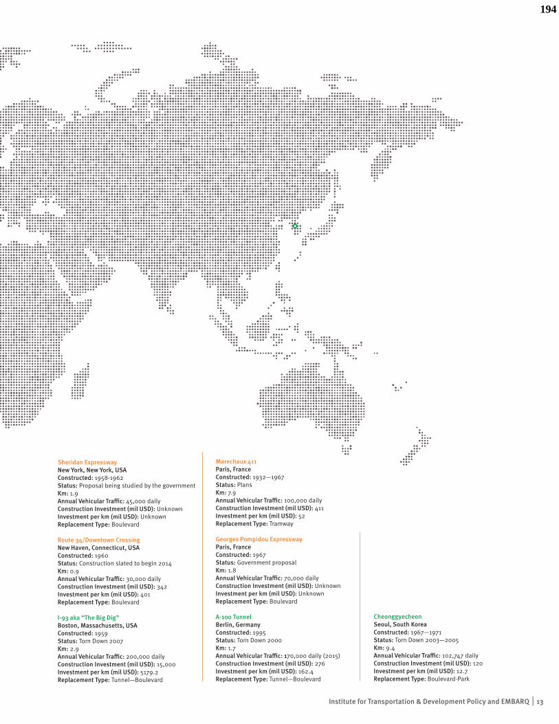
Urban Highway Removals Completed and Planned
193
Institute for Transportation & Development Policy and EMBARQ 13
Sheridan Expressway New York, New York, USA Constructed: 1958-1962 Status: Proposal being studied by the governmentKm: 1.9Annual Vehicular Traffic: 45,000 daily Construction Investment (mil USD): Unknown Investment per km (mil USD): Unknown Replacement Type: Boulevard
Route 34/Downtown Crossing New Haven, Connecticut, USA Constructed: 1960 Status: Construction slated to begin 2014Km: 0.9Annual Vehicular Traffic: 30,000 daily Construction Investment (mil USD): 342 Investment per km (mil USD): 401 Replacement Type: Boulevard
I-93 aka “The Big Dig” Boston, Massachusetts, USA Constructed: 1959 Status: Torn Down 2007Km: 2.9Annual Vehicular Traffic: 200,000 daily Construction Investment (mil USD): 15,000 Investment per km (mil USD): 5179.2 Replacement Type: Tunnel—Boulevard
Marechaux 411 Paris, France Constructed: 1932—1967 Status: PlansKm: 7.9Annual Vehicular Traffic: 100,000 daily Construction Investment (mil USD): 411 Investment per km (mil USD): 52 Replacement Type: Tramway
Georges Pompidou Expressway Paris, FranceConstructed: 1967Status: Government proposalKm: 1.8Annual Vehicular Traffic: 70,000 daily Construction Investment (mil USD): Unknown Investment per km (mil USD): Unknown Replacement Type: Boulevard
A-100 Tunnel Berlin, GermanyConstructed: 1995Status: Torn Down 2000Km: 1.7Annual Vehicular Traffic: 170,000 daily (2015) Construction Investment (mil USD): 276 Investment per km (mil USD): 162.4 Replacement Type: Tunnel—Boulevard
Cheonggyecheon Seoul, South Korea Constructed: 1967—1971Status: Torn Down 2003—2005Km: 9.4Annual Vehicular Traffic: 102,747 daily Construction Investment (mil USD): 120 Investment per km (mil USD): 12.7 Replacement Type: Boulevard-Park
194

14 The Life and Death of Urban Highways
Today, downtown Portland is now linked to the waterfront, and a new park provides residents access to the Willamette River Waterfront. Image: Brx0 via Flickr
195

Institute for Transportation & Development Policy and EMBARQ 15
BackgroundHarbor Drive, an at-grade, four-lane highway, was built in
1942. In pace with most U.S. cities, a number of additional
freeways were planned for the Portland area in the 1950s. In
1964, the state completed the first, I-5, along the west bank
of the Willamette River. Four years later in 1968 the State
Highway Department proposed widening and relocating
Harbor Drive between Front Avenue and the west bank of
the Willamette River.
But there was already a constituency in Portland that
supported creating more open space and public access
along the city’s waterfront. In fact, Portland’s 1968 Downtown
Waterfront Plan recommended eliminating the Harbor
Drive freeway and developing the land as a park to improve
the downtown riverfront. The city appointed a task force to
study the feasibility of removing the freeway and replacing
it with a park. The task force also evaluated and held a
public hearing on three alternative plans for the Harbor
Drive freeway. None of the alternatives included closing the
freeway, but that alternative was added as a result of the
public input the task force received. The freeway removal
alternative was created and presented to the city council,
and a convincing case was made that Harbor Drive’s traffic
could be absorbed by the parallel highways of I-5 and I-405.
The city council agreed to close Harbor Drive.
About the project The Harbor Drive freeway was a three-
mile long, ground-level highway along the
Willamette River that connected an industrial
neighborhood with Lake Oswego and areas south
of downtown Portland. It was built in 1942, and the
four-lane highway carried 25,000 vehicles per day (City of
Seattle, 2008).
In the late 1960s, the city of Portland decided to remove the
Harbor Drive freeway and replace it with a 37-acre park.
The city was convinced that the construction of I-5 and I-405,
two interstates running parallel to Harbor Drive, could absorb
a sufficient amount of traffic to warrant the removal.
In place of the freeway, the city built Tom McCall Waterfront
Park, which opened up the waterfront to pedestrians,
creating an important amenity for downtown. The Portland
Planning Commission took the lead on the project, which
took twelve years (1976—1988) to build using tax increment
funds. Construction began along Front Avenue and the
Ankeny Plaza area and was followed by four subsequent
redevelopment projects until the last section (north of the
Burnside Bridge) was completed in 1989 (Portland Parks
and Recreation Project Team and EDAW Inc., 2006).
Harbor Drive, Portland, ORCase Study
Harbor D
rive
���
�����
����������������
Portland, Harbor Drive
196

16 The Life and Death of Urban Highways
StakeholdersThe city of Portland, particularly the planning department
and the Oregon state governor at the time, Tom McCall,
were the driving forces behind the highway removal. Park
users, cyclists, and a citizen’s committee representing
Portland’s residents were powerful voices in the public
participation process, as were the Portland Oregon Visitors
Association and Eastside Business District groups.
EffectsThe removal of the freeway allowed for the creation
of a park, which served as the focal point for downtown
redevelopment and the only direct access point for
residents to the Willamette River. The project allowed the
city to create the Downtown Waterfront Urban Renewal
Area (DTWF URA), and since its creation in 1974, land values
in downtown Portland have increased an average of 10.4
percent annually, from a total of $466 million to more than
$1.6 billion (City of Seattle, 2008).This has helped
expand the city’s tax base and encourage more compact
and sustainable development.
In terms of mobility, before and after comparisons found
9.6 percent fewer vehicle trips on nearby roads and
formerly connecting bridges (City of Seattle, 2008). The
decrease in motor vehicle use has helped decrease air
and noise pollution in the area.
The freeway’s removal has created safer and more pleasant
spaces for pedestrians and improved the quality of life in
downtown Portland.
The redevelopment of the waterfront area has also helped
reduce crime rates partly because of new visibility earned
by removing the highway and partly due to the increase
in pedestrian “eyes on the street” (City of Seattle, 2008).
According to police bureau reports, since 1990 crime has
declined by 65 percent in the waterfront area compared
with a reduction of 16 percent in the city as a whole.
Overall the project is considered successful and even the
impacts on traffic have been minor, thanks in part to the
construction of parallel roads. Advance public notice was
used to alert drivers of the closure and divert traffic from
Harbor Drive to nearby freeways with extra capacity.
A few anchor developments, including the Yards at Union
Station to the north and River Place to the south, have
increased the availability of downtown housing. And the
city continues to expand its waterfront plans. Property
values have risen in the area, and today the Portland
Development Commission’s Downtown Waterfront
Development Strategies Project aims to increase mixed-use
development along the length of the downtown and three
blocks from the waters’ edge (pdc.us/ura/dtwf/dtwf.asp).
Before: Harbor Drive cut off the downtown waterfront from the rest of the city.
Image: City of Portland Archives, 1974
197

Institute for Transportation & Development Policy and EMBARQ 17
1968 The Oregon Highway Department proposes widening the Harbor Drive freeway; the city of
Portland acquires the Journal Building to provide land needed for the right-of-way.
The city of Portland releases its Downtown Waterfront Plan, which recommends eliminating
the Harbor Drive freeway.
1969 A new citizen’s group, Riverfront for People, is formed to fight against the state’s proposal to
widen the freeway.
August: the Portland City Club issues a report entitled “Journal Building Site Use and Riverfront
Development,” recommending waterfront redevelopment that would provide easy and attractive
public access.
August 19: Governor McCall instructs the Intergovernmental Task Force to hold a public hearing on
the future of Harbor Drive, the Task Force drafts two alternatives to the state’s proposal including
moving the freeway in a block from the waterfront and decking over the freeway and building a park
on top. The State’s traffic engineers convinced the Task Force to not consider the option of removing
the freeway altogether.
October 14: A day-long hearing is held, the public is highly critical of all of the alternatives.
November: Governor McCall calls for the creation of a citizen’s advisory committee to help plan
the project.
December: An eighteen-member citizens’ committee holds its first meeting and hires an
independent consulting firm to evaluate the options.
1973 Governor McCall continues to pressure his staff to find a way to remove the highway and replace it
with a park. Yet another alternative is drawn up and presented to the city council, which finally
approves the plan for the highway removal.
The Fremont Bridge opens, completing Interstate 405, the second Interstate through downtown
Portland, which makes Harbor Drive somewhat redundant and allows for the removal to begin.
1974 Harbor Drive is closed north of Market Street, and planning for the new park begins.
1978 The new 37-acre waterfront park opens to the public.
1984 The park is renamed Tom McCall Waterfront Park in honor of the former governor.
1999 The city extends Waterfront Park to the south, doubling its size.
Source: Adapted from Preservation Institute, 2007
Timeline
Harbor Drive Removal Project
198