the leica geosystems citymapper solution - uni-stuttgart.de · the leica geosystems citymapper...
TRANSCRIPT
Wagner et al. 89
The Leica Geosystems CityMapper Solution
RUEDIGER WAGNER, Heerbrugg, Switzerland PETER LIECKFELDT, RENE ROTHE, Neubrandenburg, Germany
JACQUES MARKRAM, Heerbrugg, Switzerland
ABSTRACT
Increasing urbanisation and ongoing inner city development and rejuvenation require more up to date 3D geospatial information to improve planning and development as well as stakeholder engagement. The Leica Geosystems CityMapper Solution brings together state-of-the-art airborne sensor technology and workflows with innovative 3D modelling and feature extraction software, creating an all-inclusive and fully integrated end-to-end workflow for urban mapping and smart city applications. Data acquisition over urban areas is made easy with the Leica RCD30 medium format camera, to date still the only classic medium format camera that provides multispectral imagery. Flown in either five or three-head configuration with nadir and oblique pointing cameras, the raw data is processed and oriented and directly ingested into the tridicon® ObliqueViewer as well as the tridicon® CityModeller or tridicon® BuildingFinder, creating a unique modelling solution.
1. DATA ACQUISITION USING THE LEICA RCD30 OBLIQUE CAMERA
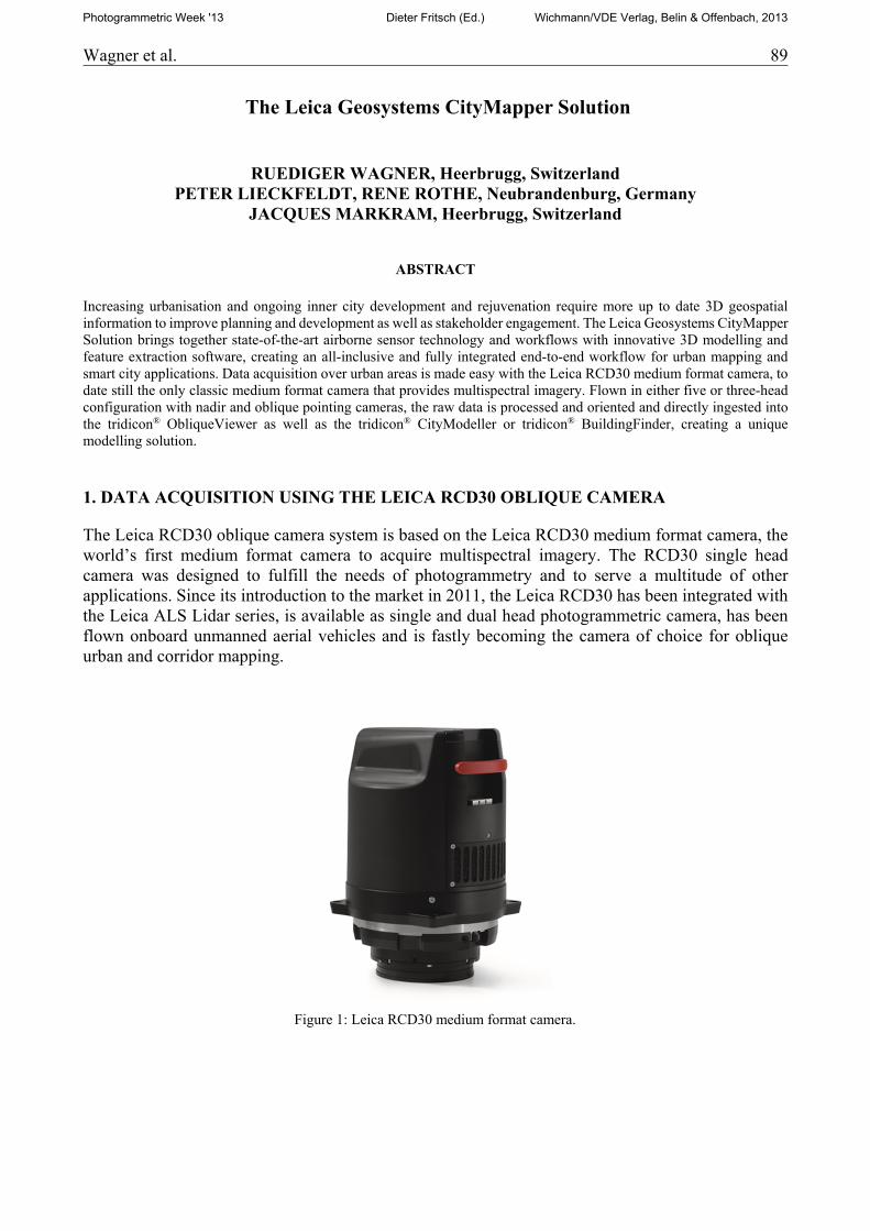
The Leica RCD30 oblique camera system is based on the Leica RCD30 medium format camera, the world’s first medium format camera to acquire multispectral imagery. The RCD30 single head camera was designed to fulfill the needs of photogrammetry and to serve a multitude of other applications. Since its introduction to the market in 2011, the Leica RCD30 has been integrated with the Leica ALS Lidar series, is available as single and dual head photogrammetric camera, has been flown onboard unmanned aerial vehicles and is fastly becoming the camera of choice for oblique urban and corridor mapping.
Figure 1: Leica RCD30 medium format camera.
Photogrammetric Week '13 Dieter Fritsch (Ed.) Wichmann/VDE Verlag, Belin & Offenbach, 2013
90 Wagner et al.
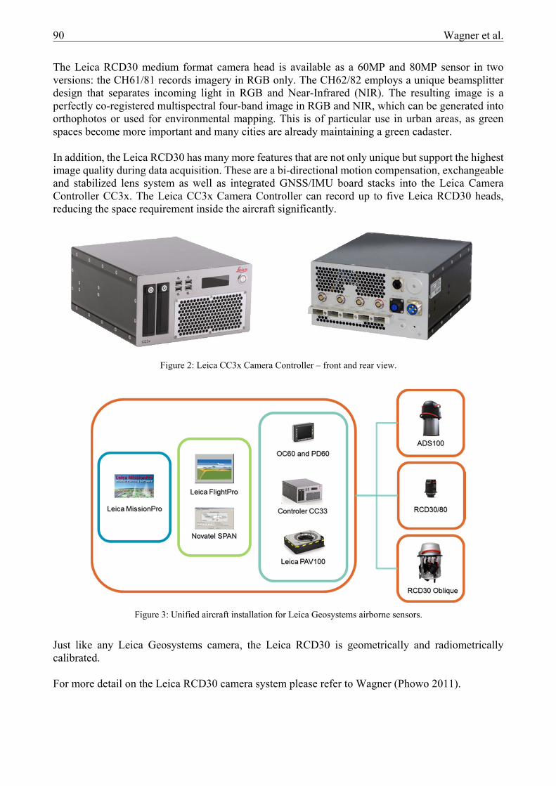
The Leica RCD30 medium format camera head is available as a 60MP and 80MP sensor in two versions: the CH61/81 records imagery in RGB only. The CH62/82 employs a unique beamsplitter design that separates incoming light in RGB and Near-Infrared (NIR). The resulting image is a perfectly co-registered multispectral four-band image in RGB and NIR, which can be generated into orthophotos or used for environmental mapping. This is of particular use in urban areas, as green spaces become more important and many cities are already maintaining a green cadaster. In addition, the Leica RCD30 has many more features that are not only unique but support the highest image quality during data acquisition. These are a bi-directional motion compensation, exchangeable and stabilized lens system as well as integrated GNSS/IMU board stacks into the Leica Camera Controller CC3x. The Leica CC3x Camera Controller can record up to five Leica RCD30 heads, reducing the space requirement inside the aircraft significantly.
Just like any Leica Geosystems camera, the Leica RCD30 is geometrically and radiometrically calibrated. For more detail on the Leica RCD30 camera system please refer to Wagner (Phowo 2011).
Figure 2: Leica CC3x Camera Controller – front and rear view.
Figure 3: Unified aircraft installation for Leica Geosystems airborne sensors.
Wagner et al. 91
1.1. Leica RCD30 Oblique Penta and Trio.
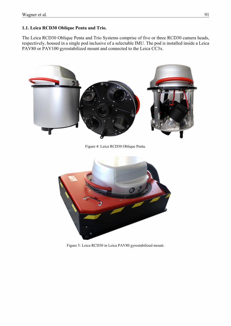
The Leica RCD30 Oblique Penta and Trio Systems comprise of five or three RCD30 camera heads, respectively, housed in a single pod inclusive of a selectable IMU. The pod is installed inside a Leica PAV80 or PAV100 gyrostabilized mount and connected to the Leica CC3x.
Figure 4: Leica RCD30 Oblique Penta.
Figure 5: Leica RCD30 in Leica PAV80 gyrostabilized mount.
92 Wagner et al.
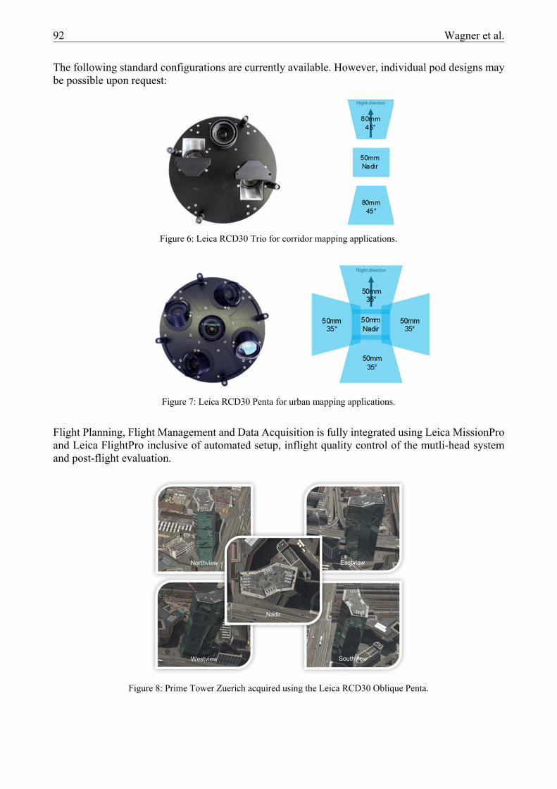
The following standard configurations are currently available. However, individual pod designs may be possible upon request:
Flight Planning, Flight Management and Data Acquisition is fully integrated using Leica MissionPro and Leica FlightPro inclusive of automated setup, inflight quality control of the mutli-head system and post-flight evaluation.
Figure 6: Leica RCD30 Trio for corridor mapping applications.
Figure 7: Leica RCD30 Penta for urban mapping applications.
Figure 8: Prime Tower Zuerich acquired using the Leica RCD30 Oblique Penta.
Wagner et al. 93
1.2. Post Processing
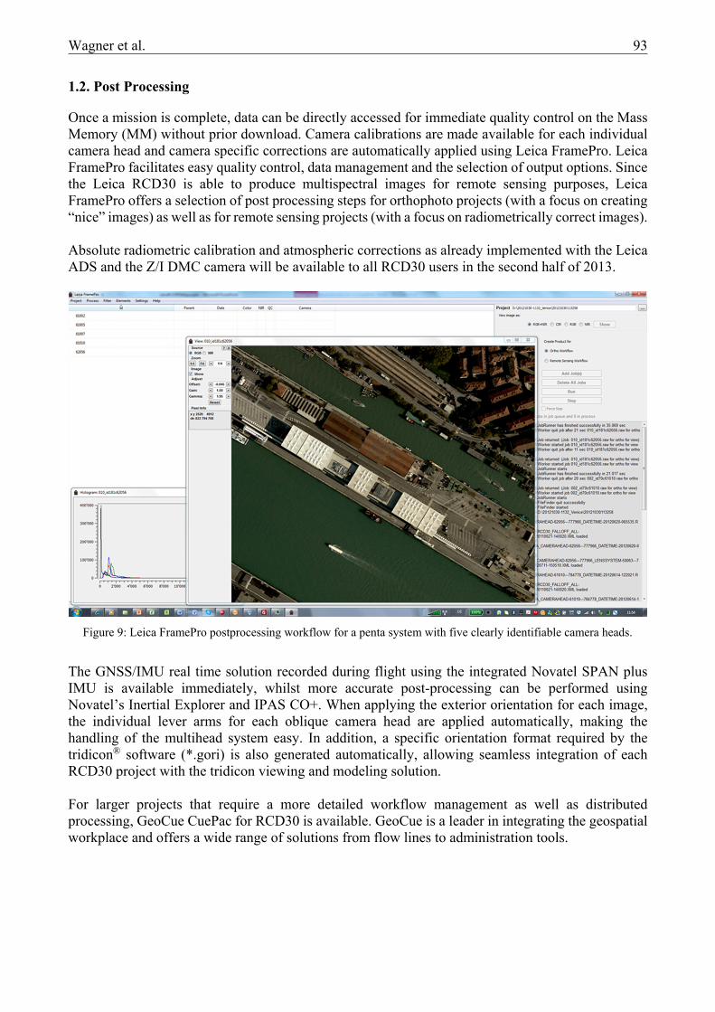
Once a mission is complete, data can be directly accessed for immediate quality control on the Mass Memory (MM) without prior download. Camera calibrations are made available for each individual camera head and camera specific corrections are automatically applied using Leica FramePro. Leica FramePro facilitates easy quality control, data management and the selection of output options. Since the Leica RCD30 is able to produce multispectral images for remote sensing purposes, Leica FramePro offers a selection of post processing steps for orthophoto projects (with a focus on creating “nice” images) as well as for remote sensing projects (with a focus on radiometrically correct images). Absolute radiometric calibration and atmospheric corrections as already implemented with the Leica ADS and the Z/I DMC camera will be available to all RCD30 users in the second half of 2013.
The GNSS/IMU real time solution recorded during flight using the integrated Novatel SPAN plus IMU is available immediately, whilst more accurate post-processing can be performed using Novatel’s Inertial Explorer and IPAS CO+. When applying the exterior orientation for each image, the individual lever arms for each oblique camera head are applied automatically, making the handling of the multihead system easy. In addition, a specific orientation format required by the tridicon® software (*.gori) is also generated automatically, allowing seamless integration of each RCD30 project with the tridicon viewing and modeling solution. For larger projects that require a more detailed workflow management as well as distributed processing, GeoCue CuePac for RCD30 is available. GeoCue is a leader in integrating the geospatial workplace and offers a wide range of solutions from flow lines to administration tools.
Figure 9: Leica FramePro postprocessing workflow for a penta system with five clearly identifiable camera heads.
94 Wagner et al.
2. 3D MODELLING USING TRIDICON® SOFTWARE SOLUTIONS
3DCon, a leader in urban modeling and 3D city mapping (formerly GTA Geoinformatik) was recently acquired by Hexagon. The tridicon® software solution offers 3D viewing, automatic building extraction from stereo imagery or pointcloud data, automatic texturing of extracted objects, object editing capabilities as well as 3D analysis tools. Leica Geosystems and tridicon® workflows are seamlessly integrated and licensed under Hexagon license management.
2.1. Oblique Viewing and Measuring
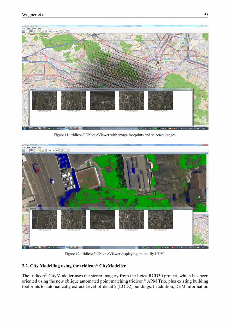
The tridicon® ObliqueViewer uses the oriented image data/project from FramePro/Ipas and provides oblique project viewing, selection and basic measurement capabilities. This includes project outline on a map, footprint outlines for all images, selectable point of view with automatic selection of relevant images (multiview), display of RGB and FCIR images, on the fly NDVI display for all RGBN images as well as basic measurements of height, width and distance. In addition, image data for further processing using tridicon® software can be selected.
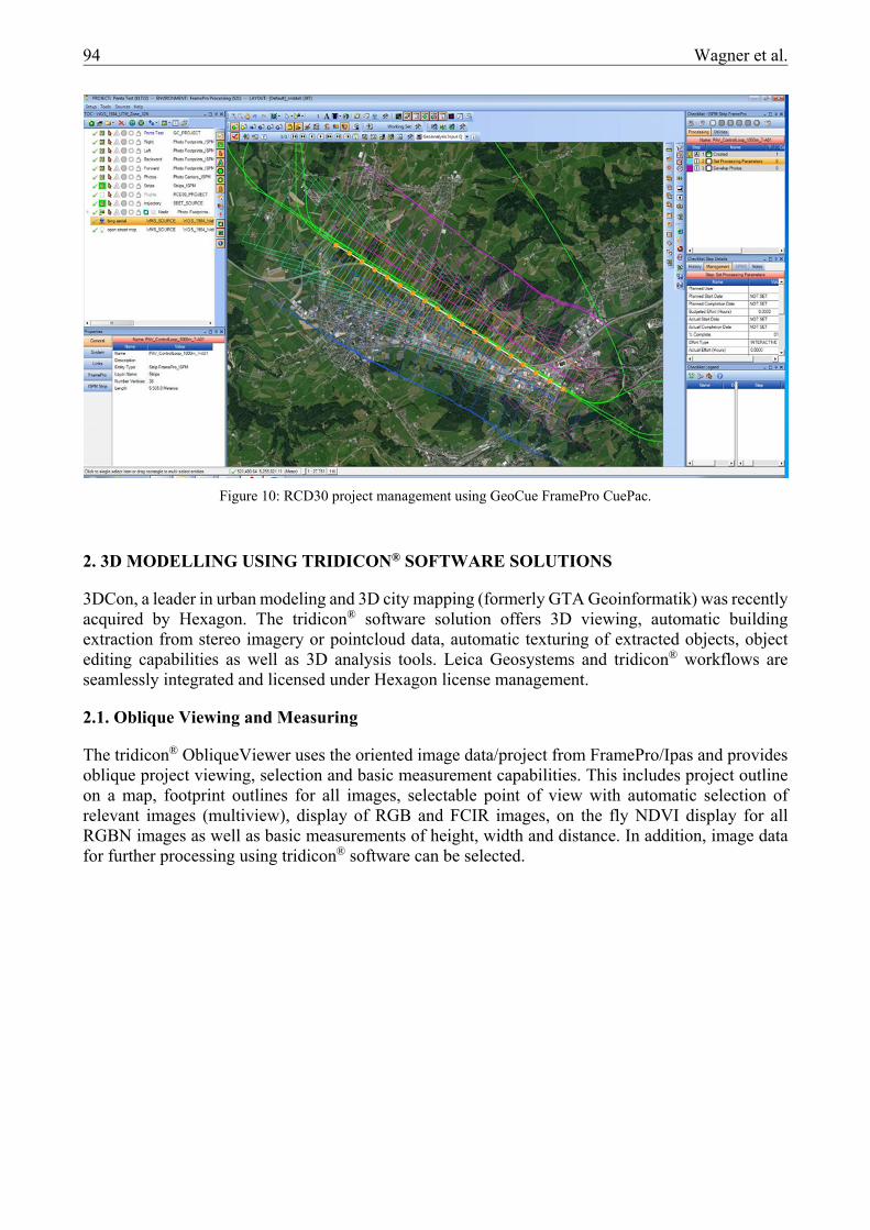
Figure 10: RCD30 project management using GeoCue FramePro CuePac.
Wagner et al. 95
2.2. City Modelling using the tridicon® CityModeller
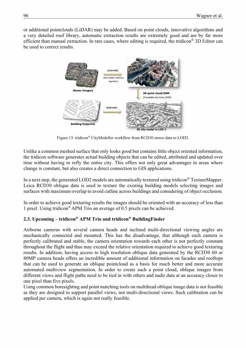
The tridicon® CityModeller uses the stereo imagery from the Leica RCD30 project, which has been oriented using the new oblique automated point matching tridicon® APM Trio, plus existing building footprints to automatically extract Level-of-detail 2 (LOD2) buildings. In addition, DEM information
Figure 11: tridicon® ObliqueViewer with image footprints and selected images.
Figure 12: tridicon® ObliqueViewer displaying on-the-fly NDVI.
96 Wagner et al.
or additional pointclouds (LiDAR) may be added. Based on point clouds, innovative algorithms and a very detailed roof library, automatic extraction results are extremely good and are by far more efficient than manual extraction. In rare cases, where editing is required, the tridicon® 3D Editor can be used to correct results.
Unlike a common meshed surface that only looks good but contains little object oriented information, the tridicon software generates actual building objects that can be edited, attributed and updated over time without having to refly the entire city. This offers not only great advantages in areas where change is constant, but also creates a direct connection to GIS applications. In a next step, the generated LOD2 models are automatically textured using tridicon® TextureMapper. Leica RCD30 oblique data is used to texture the existing building models selecting images and surfaces with maximum overlap to avoid cutline across buildings and considering of object occlusion. In order to achieve good texturing results the images should be oriented with an accuracy of less than 1 pixel. Using tridicon® APM Trio an average of 0.5 pixels can be achieved.
2.3. Upcoming – tridicon® APM Trio and tridicon® BuildingFinder
Airborne cameras with several camera heads and inclined multi-directional viewing angles are mechanically connected and mounted. This has the disadvantage, that although each camera is perfectly calibrated and stable, the camera orientation towards each other is not perfectly constant throughout the flight and thus may exceed the relative orientation required to achieve good texturing results. In addition, having access to high resolution oblique data generated by the RCD30 60 or 80MP camera heads offers an incredible amount of additional information on facades and rooftops that can be used to generate an oblique pointcloud as a basis for much better and more accurate automated multiview segmentation. In order to create such a point cloud, oblique images from different views and flight paths need to be tied in with others and nadir data at an accuracy closer to one pixel than five pixels. Using common boresighting and point matching tools on multihead oblique image data is not feasible as they are designed to support parallel views, not multi-directional views. Such calibration can be applied per camera, which is again not really feasible.
Figure 13: tridicon® CityModeller workflow from RCD30 stereo data to LOD2.
Wagner et al. 97
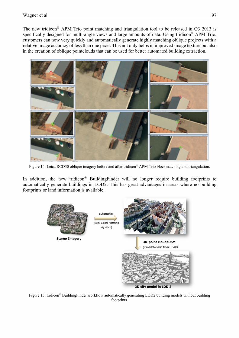
The new tridicon® APM Trio point matching and triangulation tool to be released in Q3 2013 is specifically designed for multi-angle views and large amounts of data. Using tridicon® APM Trio, customers can now very quickly and automatically generate highly matching oblique projects with a relative image accuracy of less than one pixel. This not only helps in improved image texture but also in the creation of oblique pointclouds that can be used for better automated building extraction.
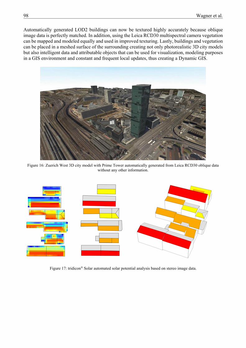
In addition, the new tridicon® BuildingFinder will no longer require building footprints to automatically generate buildings in LOD2. This has great advantages in areas where no building footprints or land information is available.
Figure 15: tridicon® BuildingFinder workflow automatically generating LOD2 building models without building footprints.
Figure 14: Leica RCD30 oblique imagery before and after tridicon® APM Trio blockmatching and triangulation.
98 Wagner et al.
Automatically generated LOD2 buildings can now be textured highly accurately because oblique image data is perfectly matched. In addition, using the Leica RCD30 multispectral camera vegetation can be mapped and modeled equally and used in improved texturing. Lastly, buildings and vegetation can be placed in a meshed surface of the surrounding creating not only photorealistic 3D city models but also intelligent data and attributable objects that can be used for visualization, modeling purposes in a GIS environment and constant and frequent local updates, thus creating a Dynamic GIS.
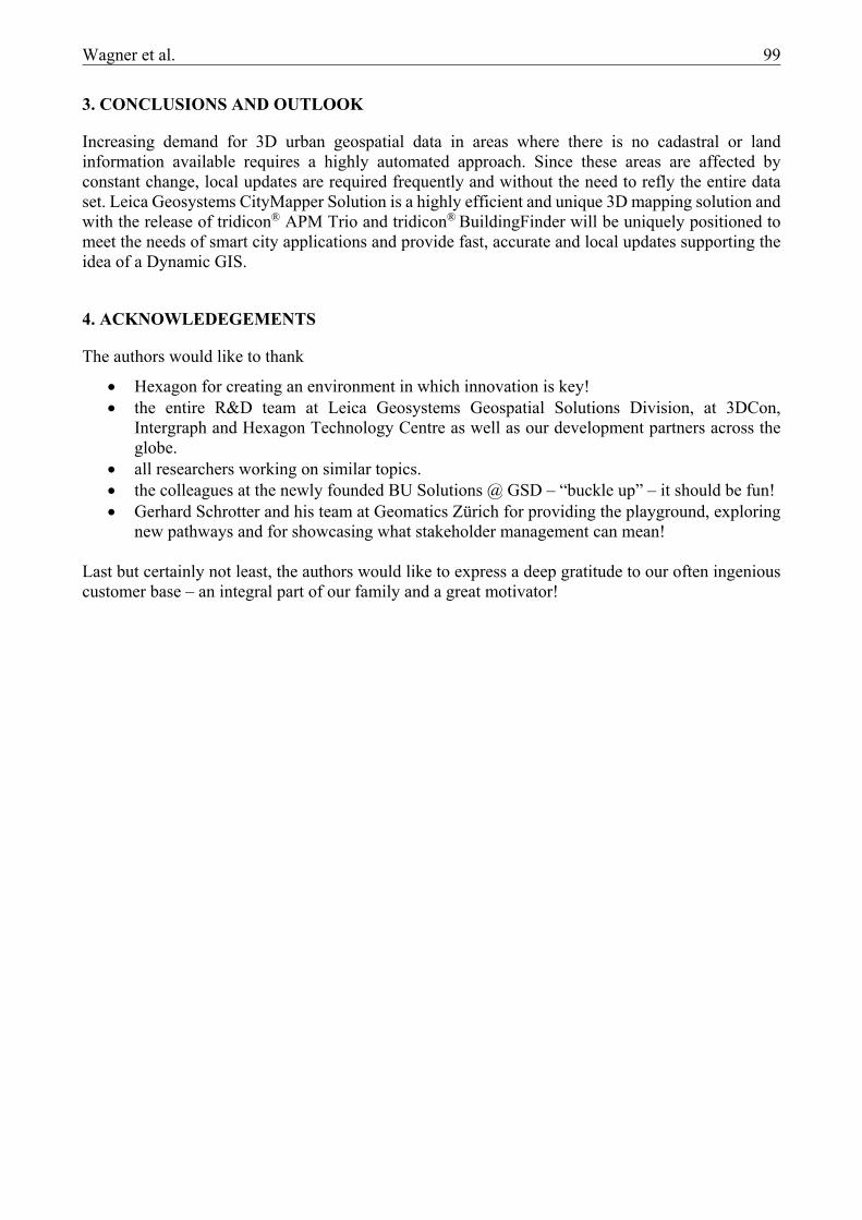
Figure 16: Zuerich West 3D city model with Prime Tower automatically generated from Leica RCD30 oblique data without any other information.
Figure 17: tridicon® Solar automated solar potential analysis based on stereo image data.
Wagner et al. 99
3. CONCLUSIONS AND OUTLOOK
Increasing demand for 3D urban geospatial data in areas where there is no cadastral or land information available requires a highly automated approach. Since these areas are affected by constant change, local updates are required frequently and without the need to refly the entire data set. Leica Geosystems CityMapper Solution is a highly efficient and unique 3D mapping solution and with the release of tridicon® APM Trio and tridicon® BuildingFinder will be uniquely positioned to meet the needs of smart city applications and provide fast, accurate and local updates supporting the idea of a Dynamic GIS.
4. ACKNOWLEDEGEMENTS
The authors would like to thank
Hexagon for creating an environment in which innovation is key! the entire R&D team at Leica Geosystems Geospatial Solutions Division, at 3DCon,
Intergraph and Hexagon Technology Centre as well as our development partners across the globe.
all researchers working on similar topics. the colleagues at the newly founded BU Solutions @ GSD – “buckle up” – it should be fun! Gerhard Schrotter and his team at Geomatics Zürich for providing the playground, exploring
new pathways and for showcasing what stakeholder management can mean! Last but certainly not least, the authors would like to express a deep gratitude to our often ingenious customer base – an integral part of our family and a great motivator!