the increased flows of the missouri river not only caused
TRANSCRIPT
17North Dakota Water ■ November 2012 North Dakota Water ■ November 201216
FROM THE NORTH DAKOTA STATE WATER COMMISSION
The
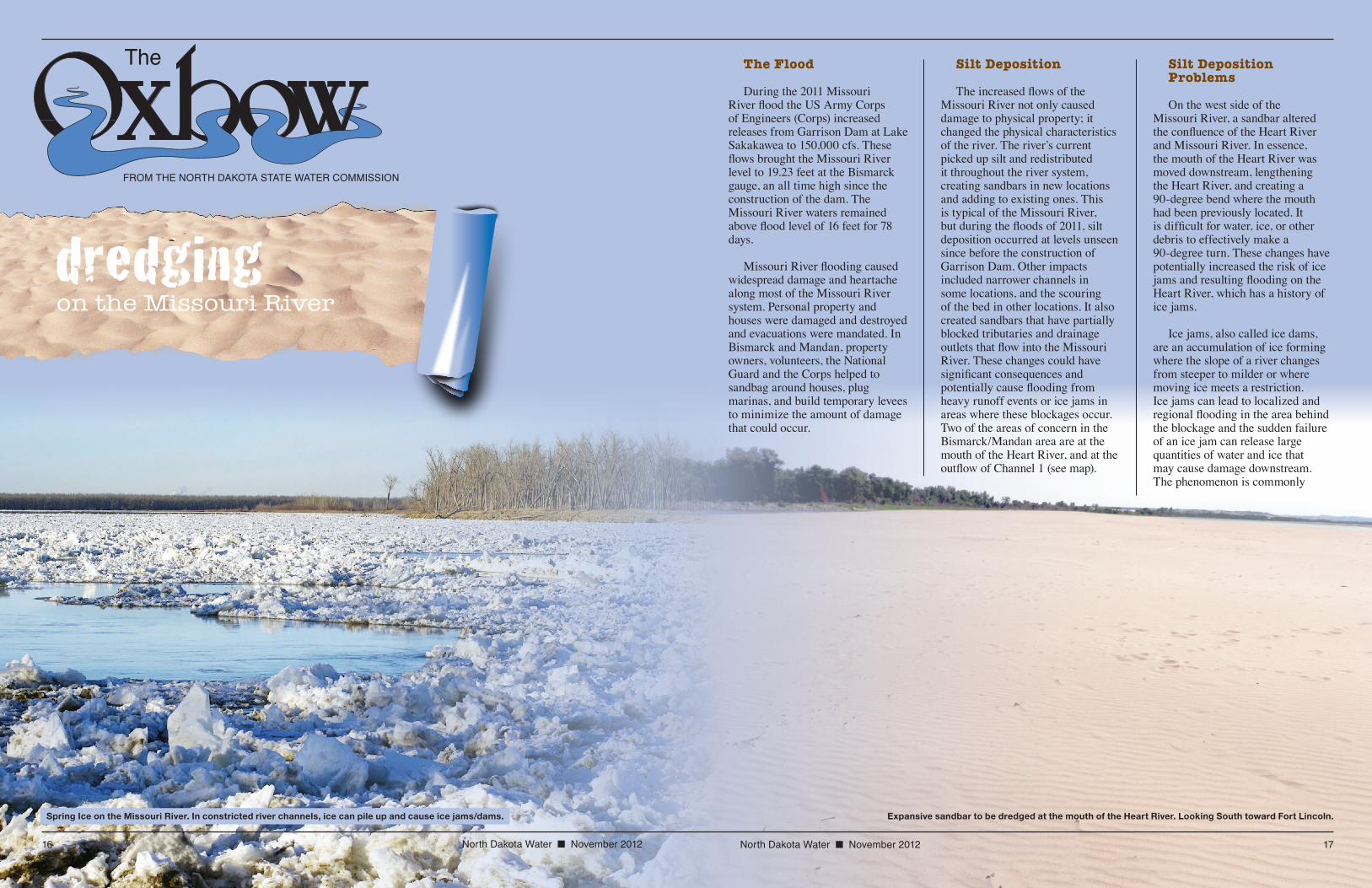
Expansive sandbar to be dredged at the mouth of the Heart River. Looking South toward Fort Lincoln.
dredgingon the Missouri River
Spring Ice on the Missouri River. In constricted river channels, ice can pile up and cause ice jams/dams.
The Flood
During the 2011 Missouri River flood the US Army Corps of Engineers (Corps) increased releases from Garrison Dam at Lake Sakakawea to 150,000 cfs. These flows brought the Missouri River level to 19.23 feet at the Bismarck gauge, an all time high since the construction of the dam. The Missouri River waters remained above flood level of 16 feet for 78 days.
Missouri River flooding caused widespread damage and heartache along most of the Missouri River system. Personal property and houses were damaged and destroyed and evacuations were mandated. In Bismarck and Mandan, property owners, volunteers, the National Guard and the Corps helped to sandbag around houses, plug marinas, and build temporary levees to minimize the amount of damage that could occur.
Silt Deposition
The increased flows of the Missouri River not only caused damage to physical property; it changed the physical characteristics of the river. The river’s current picked up silt and redistributed it throughout the river system, creating sandbars in new locations and adding to existing ones. This is typical of the Missouri River, but during the floods of 2011, silt deposition occurred at levels unseen since before the construction of Garrison Dam. Other impacts included narrower channels in some locations, and the scouring of the bed in other locations. It also created sandbars that have partially blocked tributaries and drainage outlets that flow into the Missouri River. These changes could have significant consequences and potentially cause flooding from heavy runoff events or ice jams in areas where these blockages occur. Two of the areas of concern in the Bismarck/Mandan area are at the mouth of the Heart River, and at the outflow of Channel 1 (see map).
Silt DepositionProblems
On the west side of the Missouri River, a sandbar altered the confluence of the Heart River and Missouri River. In essence, the mouth of the Heart River was moved downstream, lengthening the Heart River, and creating a 90-degree bend where the mouth had been previously located. It is difficult for water, ice, or other debris to effectively make a 90-degree turn. These changes have potentially increased the risk of ice jams and resulting flooding on the Heart River, which has a history of ice jams.
Ice jams, also called ice dams, are an accumulation of ice forming where the slope of a river changes from steeper to milder or where moving ice meets a restriction. Ice jams can lead to localized and regional flooding in the area behind the blockage and the sudden failure of an ice jam can release large quantities of water and ice that may cause damage downstream. The phenomenon is commonly

18 North Dakota Water ■ November 2012
associated with blockages of ice that prevent the late winter or early spring drainage of rain and melting snow.
On the east side of the river, another sandbar has developed. This sandbar is located in front of the storm sewer outfall for south Bismarck (Channel 1) and has diminished the ability for the south Bismarck storm sewer system to evacuate runoff into the river. In its current state, water cannot flow directly into the river; rather, it must back up into the Southport area before draining into the Missouri River. If a substantial storm were to occur, south Bismarck could experience considerable flooding due to the blocked storm sewer outlet.
Solutions
On September 5, 2012, Governor Jack Dalrymple, Senator John Hoeven, State Engineer Todd Sando, representatives from the Corps, and representatives from local government met to evaluate the siltation problems at the confluence of the Heart and Missouri Rivers and at Channel 1.
The Corps is working with state and federal agencies to explore a permanent mitigation plan. This plan will identify ways to control and remove sediment from key problem areas. Unfortunately, the study that is associated with this plan will not be completed until March of 2013. Until then, the Corps will not participate in dredging activities to remove sediment on the Missouri.
Even without Corps participation, dredging operations to clear the blockages will take place in each
of the locations. It is estimated that it will cost approximately $300,000 to dredge the area near the Heart River, while the area around Channel 1 will cost approximately $250,000. Generally, the costs of dredging activities are not considered to be eligible for cost-share through the State Water Commission (SWC). However, given the circumstances, the SWC voted to approve funding for these two projects.
At the September 17, 2012, SWC meeting, 75% cost-share was approved for these projects. Burleigh and Morton Counties will be responsible for the engineering, permitting, and contract administration for their respective projects.
Provided that all engineering can be completed and the appropriate Corps permits are obtained, it is expected that these projects will be completed during the fall of 2012.
North Dakota State Water CommissionTodd Sando, P.E., State Engineer900 East Boulevard Ave. • Bismarck, ND 58505(701) 328-2750 • http: //swc.nd.govThe State Water Commission does not discriminate on the basis of race, color, national origin, sex, age, or disability in employment or the provision of services.
Proposed area and description of sandbar dredging projects.
Heart River
Channel #1Missouri RiverFort
AbrahamLincoln
State Park
DredgeChannel
RiverwoodDrive
DeepenExistingChannel
DredgeChannel
DredgeSand
Deposit
BISMARCK
MANDAN83
94
94
1806
1806
BISMARCK
MANDAN83
94
94
1806
FORTABRAHAMLINCOLN
STATE PARK