the importance of ground water in the great lakes region · the importance of ground water in the...
TRANSCRIPT

U.S. Department of the InteriorU.S. Geological Survey
Water-Resources Investigations Report 00–4008
The Importance of Ground Waterin the Great Lakes Region
Sandstone, carbonate, and shale aquifer
Rocks that are generally poorly permeable(mostly shale)
Carbonate aquifer
Carbonate and sandstone aquifer
Sandstone aquiferGranite and gneiss(moderate to poor aquifer)
Great Lakes Basin boundary
Bedrock aquifers of the Great Lakes Basin
0 50 100 MILES
0 50 100 KILOMETERS
L a k e S u p e r i o r
La
ke
Mi c
hi g
a n L a k eH u r o n
GeorgianBay
L a k e E r i e
Lake Ontario

I
The Importance of Ground Water in theGreat Lakes RegionBy N.G. Grannemann, R.J. Hunt, J.R. Nicholas, T.E. Reilly, and T.C. Winter
U.S. GEOLOGICAL SURVEYWater-Resources Investigations Report 00–4008
Lansing, Michigan2000

II
U.S. DEPARTMENT OF THE INTERIORBruce Babbitt, Secretary
U.S. GEOLOGICAL SURVEYCharles G. Groat, Director
For additional information Copies of this report can bewrite to: purchased from:
District Chief U.S. Geological SurveyU.S. Geological Survey Branch of Information ServicesWater Resources Division Federal Center6520 Mercantile Way, Suite 5 Box 25286Lansing, MI 48911 Denver, CO 80225-0286

III
Why do we need to know more about ground-water conditions in the Great Lakes Region? ............................................... 1
What are the major ground-water issues in the Great Lakes Region? ................................................................................... 1
Geology establishes the framework for aquifers .................................................................................................................... 3
How does ground water move in the Great Lakes Region? ................................................................................................... 3
Most ground water moves in local flow systems ..................................................................................................... 3
Most ground water for municipal supply comes from regional ground-water flow systems .................................. 4
How is ground water replenished? ......................................................................................................................................... 5
How much ground water is pumped in the Great Lakes Region? .......................................................................................... 6
Some areas where the effects of ground-water pumping have been evaluated ...................................................................... 6
Chicago-Milwaukee Area ........................................................................................................................................ 7
Green Bay-Fox River Area ...................................................................................................................................... 8
Toledo, Ohio Area .................................................................................................................................................... 8
Irrigation throughout the Great Lakes watershed .................................................................................................... 9
Ground-water and surface-water interactions ...................................................................................................................... 10
Ground-water flow into the Great Lakes .............................................................................................................................. 10
A relatively small amount of ground water flows directly to the Great Lakes ...................................................... 11
Ground water keeps streams flowing during periods of low surface runoff .......................................................... 11
Ground water, wetlands, and stream ecology ....................................................................................................................... 11
Ground water and wetlands .................................................................................................................................... 11
Ground water provides refuge for aquatic organisms ............................................................................................ 12
Summary and conclusions .................................................................................................................................................... 12
Issues related to the amount of ground water ........................................................................................................ 12
Issues related to the interaction of ground water and surface water ...................................................................... 12
Issues related to changes in ground-water quality as development expands ......................................................... 13
Issues related to ecosystem health and quantity and quality of ground water ....................................................... 13
References ............................................................................................................................................................................ 13
1. Map showing surficial geology of the Great Lakes Basin .............................................................................................. 1
2. Maps showing
A. Bedrock aquifers of the Great Lakes Basin ........................................................................................................ 2
B. Approximate extent of the freshwater bearing carbonate aquifer in Ohio, Indiana, Illinois, and parts of Michigan and Wisconsin .................................................................................. 2
C. Approximate extent of the sandstone aquifer west of Lake Michigan ............................................................... 2
3. Geologic section showing generalized local and regional ground-water flow systems in the Great Lakes Region ............................................................................................................................. 3
4. Map showing estimated ground-water withdrawal rates for some major U.S. metropolitan areas ................................ 4
5. Diagram showing generalized ground-water flow
A. Under natural conditions .................................................................................................................................... 5
B. Affected by pumping .......................................................................................................................................... 5
CONTENTS
FIGURES

IV
6. Map showing decline in water levels in the sandstone confined aquifer, Chicago and Milwaukee areas, 1864–1980 ....................................................................................................................................... 6
7. Generalized section showing aquifers, confining unit, and direction of ground-water flow near Green Bay, Wisconsin .................................................................................................................................................. 7
8. Maps showing simulated potentiometric surfaces in the sandstone aquifer, northeastern Wisconsin
A. In 1957 ................................................................................................................................................................ 8
B. In 1990 ................................................................................................................................................................ 8
9. Map showing potentiometric surface for the carbonate aquifer near Toledo, Ohio, July 1986 ...................................... 9
10. Schematic diagram showing approximate average water budget for Lake Michigan .................................................... 9
11. Map showing average ground-water and surface-runoff components of selected watersheds in the U.S. portion of the Great Lakes Basin ............................................................................ 10
CONVERSION FACTORS AND VERTICAL DATUM
Multiply By To obtain
cubic foot per second (ft3/s) 0.02832 cubic meter per second
million gallons per day (Mgal/d) 0.04381 cubic meter per second
cubic mile per year (mi3/yr) 4.16832 cubic kilometers per year
Sea level: In this report “sea level” refers to the National Geodetic Vertical Datum of 1929 (NGVD of 1929)—a geodeticdatum derived from a general adjustment of the first-order level nets of both the United States and Canada, formerly calledSea Level datum of 1929.

1
The Importance of Ground Water in the Great Lakes Region
Figure 1. Surficial geology of theGreat Lakes Basin.
“Governments should immediately take steps to en-hance groundwater research in order to better under-stand the role of groundwater in the Great Lakes Basin.“
—Interim International Joint Commission (IJC) Report, 1999,Recommendation IV, Page 30
Although more than 1,000 mi3 of ground water are storedin the basin—a volume of water that is approximately equalto that of Lake Michigan—development of the ground-water resource must be carefully planned. Development ofthe ground-water resource removes water from storage andalters the paths of ground-water flow. Ground water thatnormally discharges to streams, lakes, and wetlands can becaptured by pumping (the most common form of develop-ment), which may deplete or reduce inflows to the GreatLakes.
Ground water is important to ecosystems in the GreatLakes Region because it is, in effect, a large, subsurfacereservoir from which water is released slowly to provide areliable minimum level of water flow to streams, lakes, andwetlands. Ground-water discharge to streams generallyprovides good quality water that, in turn, promotes habitatfor aquatic animals and sustains aquatic plants duringperiods of low precipitation. Because of the slow move-ment of ground water, the effects of surface activities onground-water flow and quality can take years to manifestthemselves. As a result, issues relative to ground water areoften seemingly less dire than issues related to surface wateralone.
Ground water is a major natural resource in the GreatLakes Region that helps link the Great Lakes and theirwatershed. This linkage needs to be more fully understoodand quantified before society can address some of theimportant water-resources issues in the region.
“The Great Lakes aquatic ecosystem is made up not onlyof the lakes themselves, but also of the complex networkof tributaries and groundwater on which the lakes de-pend.”
—Interim IJC Report, Page 25
By N.G. Grannemann, R.J. Hunt, J.R. Nicholas, T.E. Reilly, and T.C. Winter
Why do we need to know more about ground-waterconditions in the Great Lakes Region?
Ground water is a major natural resource in the GreatLakes Region that helps link the Great Lakes and theirwatershed. This linkage needs to be more fully under-stood and quantified before society can address someof the important water-resources issues in the GreatLakes.
The Great Lakes constitute the largest concentration ofunfrozen fresh surface water in the western hemisphere—about 5,440 mi3. Because the quantity of water in the lakesis so large, ground water in the Great Lakes Basin is oftenoverlooked when evaluating the hydrology of the region.Ground water, however, is more important to the hydrologyof the Great Lakes and to the health of ecosystems in thewatershed than is generally recognized.
The major ground-water resources issues in the GreatLakes Region revolve around 1) the quantity of groundwater, 2) ground-water and surface-water interaction,3) changes in ground-water quality as developmentexpands, and 4) ecosystem health in relation to quantityand quality of water.
What are the major ground-water issues in theGreat Lakes Region?
Silt and clay (glacial lake deposits)
Sand and gravel (outwash, alluvial and ice contact deposits)
Unstratified Drift
Stratified Drift
Till (ground and end moraines)
Bedrock areas where the glacial cover is absent (e.g. parts of Canadian Shield) are not distinguished.
EXPLANATION
Lake Superior
Lake
Mic
hi
gan
LakeHuron
Lake Erie
Lake Ontario
from The Great Lakes: An Environmental Atlas and Resource Book, 1995

2
Figure 2. (A) Bedrock aquifers of the Great Lakes Basin (modified from Great Lakes Commission,1975); (B) Approximate extent of the freshwater bearing carbonate aquifer in Ohio, Indiana, Illinois,and parts of Michigan and Wisconsin (modified from Casey, 1996, figure 14); (C) Approximate extentof the sandstone aquifer west of Lake Michigan (modified from Young, 1992, figure 16).
A
B
C
A major attraction of the Great Lakes Region is theabundant water supply on which manufacturing, powergeneration, transportation, agricultural, and recreationalsectors have historically relied. Most large public watersupplies are obtained from the lakes themselves, but groundwater is the source of drinking water for about 8.2 millionpeople within the watershed. Although most residents ofChicago use water from Lake Michigan, many people in theChicago suburbs who live outside of the watershed, but areclose to it, use ground water as a source of supply. As thesuburban areas near the watershed boundary expand, moreand more people depend on ground water to supply house-hold water needs. Small manufacturing companies in sub-urban locations also are increasing their ground-water use.As communities encroach upon agricultural areas, conflictsbetween agricultural and other ground-water users willincrease (Alley and others, 1999). Therefore, ground-waterresources need to be characterized according to their occur-rence, availability, quality, and use to develop a sustainablesupply for all uses.
Pumping ground water can capture water from or inter-cept flow to streams and alter the area that contributesground water to the Great Lakes. Thus, ground-water with-drawals can divert ground water that would normally dis-charge to the Great Lakes system.
“Water quantity and water quality are inextricably linked.For most uses, quantity alone does not satisfy thedemand.”
—Interim IJC Report, Page 26
In addition to water quantity issues in the Great LakesRegion, water quality also can be of concern. As develop-ment increases, activities that could threaten the quality ofground water also increase. Human health needs to besafeguarded, as does the health of many other organismsthat rely on clean water. Thus, the major ground-waterresource issues in the Great Lakes Region revolve around1) the quantity of ground water, 2) the interaction of groundwater and surface water, 3) changes in ground-water qual-ity as development expands, and 4) ecosystem health inrelation to quantity and quality of water. In summary,ground water is an essential part of the Great Lakes Regionwater-supply system. It is a critical resource for maintain-ing human health and healthy ecosystems.
Sandstone, carbonate, and shale aquifer
Rocks that are generally poorly permeable(mostly shale)
Carbonate aquifer
Carbonate and sandstone aquifer
Sandstone aquifer
Granite and gneiss(moderate to poor aquifer)
Great Lakes Basin boundary
EXPLANATION
0 50 100 MILES
0 50 100 KILOMETERS
L a k e S u p e r i o r
La
ke
Mi c
hi g
a n L a k eH u r o n
GeorgianBay
L a k e E r i e
Lake Ontario
LakeMichigan
Lake Erie
ILLINOIS
WIS.MICHIGAN
INDIANA
KENTUCKY
OHIO
EXPLANATIONAquifer boundary—aquifer extends beyond edge of map
IOWA
MINNESOTAWISCONSIN
ILLINOIS
MISSOURI
MICHIGANIN
DIAN
A
NEB
RASK
ASO
UTH
DAKO
TA
La
ke
Mic
hi g
an
EXPLANATIONAquifer boundary—dashed where uncertain
Areas of aquifer where water is generally too saline for most uses
[No data beneath most of Lake Michigan]

3
Figure 3. Generalized local and regional ground-water flow systems in the Great Lakes Region.
Geology establishes the framework for aquifers
Ground water is present throughout the Great LakesBasin, but the quantity that can be withdrawn varies de-pending on the characteristics of the water-bearing rocksand sediments (aquifers). Unconsolidated material that wasdeposited at or near the land surface as a result of large-scaleglacial ice advances and retreats during the last 2 millionyears make up the most productive aquifers. These depositsare as much as 1,200 feet thick in parts of Michigan and areseveral hundred feet thick in buried bedrock valleys inIllinois, Wisconsin, and New York. The deposits are thin ornonexistent in areas where bedrock that was not easilyeroded by glacial ice is exposed at land surface. Most glacialdeposits are composed of mixtures of sand and gravel, andsilt and clay (fig. 1). Sand and gravel deposits (outwash andice-contact deposits) are the most productive aquifers be-cause they have greater permeability and effective porositythan do the finer grained deposits. Some areas with silt andclay at the surface (till or glacial lake deposits) contain morepermeable deposits at depth and are able to yield moderateto large amounts of water to wells. In general, however, thesilt and clay deposits are not aquifers.
Bedrock aquifers are generally widespread throughoutthe region and are more continuous than the aquifers inglacial deposits. Some bedrock aquifers in the region ex-tend far beyond the watershed boundaries. The relationsbetween ground water in these aquifers and water in theGreat Lakes is complicated because ground-water dividesand watershed boundaries may not coincide. Carbonaterocks (limestone and dolomite) are the most commonbedrock aquifers in the region (fig. 2A). Natural processesmay increase permeability by dissolving carbonate miner-
als in these aquifers, but this increased permeability makesthe aquifers more vulnerable to contamination. The mostextensive carbonate aquifer in the region consists of a seriesof limestones and dolomites that underlie a large part of theupper Midwest (fig. 2B). Sandstone aquifers are the nextmost common bedrock aquifer. An extensive sandstoneaquifer underlies much of the northern Midwest and evenextends under Lake Michigan (fig. 2C). In general, shale,and igneous and metamorphic bedrock have limited water-yielding capacity, and they are not considered regionalaquifers.
How does ground water move in the Great LakesRegion?
Aquifers and confining units (relatively impermeablerocks and sediments) make up the ground-water system inthe Great Lakes watershed. This system stores water andacts as a conduit for water to move from recharge areas todischarge areas (fig. 3). Recharge takes place betweenstreams in areas that occupy most of the land surface.Ground water moves in both local and regional flow sys-tems.
Most ground water moves in local flow systems
To improve our understanding of the importance of un-consolidated aquifers in the Great Lakes watershed,new geologic maps that show the extent, thickness, andboundaries of these aquifers are needed.
Ground water in local flow systems commonly travelsrelatively short distances underground before discharging
1
2
Local ground-water system
Regional ground-water system
Water table
Great Lake
Sediment
Highly permeable aquifer
Poorly permeable confining unit
Very poorly permeable bedrock
Direction of ground-water flow,local ground-water system
Direction of ground-water flow,regional ground-water system
EXPLANATION
Unsaturated zone
Surface-water body
11
2
2
2
2
2
1

4
Figure 4. Estimated ground-water withdrawal rates for some major U.S. metropolitan areas (data not available for Canadian areas).
to a stream, lake, or wetland. The Great Lakes Region hasan abundance of small streams, and most ground-waterflow takes place in these shallow systems. The amount ofground water moving through these systems is not wellquantified, however, because most water-supply studieshave focused on deeper regional flow systems. The mostproductive shallow aquifers are composed of sand andgravel (fig. 1). The extent of these deposits near the landsurface is commonly known and illustrated on maps, but thethickness and capability to transmit water often is not wellknown. To improve our understanding of the importance ofground-water flow in unconsolidated aquifers in the GreatLakes watershed, new geologic maps that show the extent,thickness, and boundaries of these aquifers are needed(Central Great Lakes Geologic Mapping Coalition, 1999).
Most ground water for municipal supply comes fromregional ground-water flow systems
More work needs to be done to define and quantify theinteractions between regional ground-water flow andground-water discharge to the Great Lakes.
Regional ground-water flow systems are usually deeperbelow land surface and have longer flow paths than localflow systems (fig. 3). Confining units that restrict flow ofwater between the systems commonly separate local from
regional flow, but thick, unconfined aquifers may haveregional scale ground-water flow. In the Great Lakes Re-gion, regional ground-water flow occurs in both glacialdeposits and bedrock aquifers, depending on the hydraulicproperties of the aquifers and confining units, and thetopographic relief.
Glacial deposits usually consist of a complex assemblageof sediments (fig. 3). In some parts of the region, glacialdeposits are as much as 1,200 feet in thickness. As thicknessincreases, the complexity of the sediment assemblage usu-ally increases. These sediments need to be mapped usingestablished three-dimensional mapping techniques to un-derstand their geological framework (Bhagwat and Berg,1991). Hydraulic characteristics of the sediments also needto be determined for the aquifers that are increasingly beingtapped for water supply. Armed with this hydrogeologiccharacterization, water managers will be able to make betterdeterminations of sustainable withdrawal rates from theregion’s aquifers.
The extent, thickness, hydraulic properties, and generaldirections of flow in the most used bedrock aquifers havebeen described by regional aquifer studies conducted by theUSGS (Sun and others, 1997) and by State and localagencies (Bleuer and others, 1991; Batten and Bradbury,1996; and Passero and others, 1981). Although these stud-ies provide a baseline of hydrologic and geologic informa-tion, more work needs to be done to define and quantify theinteractions between regional ground-water flow andground-water discharge to the Great Lakes. Divides that aretransient barriers to ground-water movement are estab-
200
90
7878
82
63
27
9315
39
30
11
27 36
10
7
12 15
33
L a k e S u p e r i o r
L a k eH u r o n
L a k eE r i e
Lake Ontario
Parry Sound
Sudbury
Sault Ste. Marie
Sault Ste. Marie
Petoskey
Traverse City
Bay City
Saginaw
FlintGrand Rapids
Detroit
Toledo
Milwaukee
Green Bay
Marquette
Toronto
Hamilton
Trenton
Kingston
Duluth
Thunder Bay
Marathon
Owen Sound
LondonSarnia
Erie
Buffalo
Niagara Falls
Cleveland/AkronChicago
Rochester Syracuse
Oswego
MassenaCornwall
Montréal
Trois RivièresCANADA
U.S.A.
L a k e S u p e r i o r
Lake
Mic
hi g
an
L a k eH u r o n
L a k eE r i e
Lake Ontario
GeorgianBay
Great Lakes Drainage Basin
U.S.A./Canada border
Cities/towns
EXPLANATION
Windsor
Ground-water withdrawalrate, in millions of gallons per day
Lansing
Kalamazoo Battle Creek/Jackson
Portage/Michigan City
South Bend/Mishawaka
Elkhart/Goshen
Fort Wayne
0 50 100 MILES
0 50 100 KILOMETERSSource map: Environment Canada

5
lished by a combination of natural and human-inducedstresses on the aquifers. In some areas, bedrock aquifersmay discharge large quantities of water to the lakes, but thedata needed to quantify the amount of flow have not beencollected. In addition, the effects on the Great Lakes ofpumping from regional aquifers are unknown. Many ground-water issues take time to be recognized, but, because of thelarge volumes and resulting long travel times for water inregional flow systems, the time lags expected are usuallymuch longer than for local flow systems. Thus, adverseeffects of withdrawals may take years to manifest them-selves.
How is ground water replenished?
Ground-water recharge rates estimated in previous stud-ies represent the approximate range of recharge to thewater table in the entire Great Lakes Region. A compre-hensive study for the entire watershed is needed tomore completely determine the importance of groundwater in the hydrologic budget of the Great Lakes.
Recharge is the term that is commonly used to describethe process of adding water to the ground-water system.
Although it is difficult to directly measure the amount ofrecharge, it is important to estimate recharge rates to under-stand the effects of ground water on other hydrologicprocesses in the basin and to assess how activities at the landsurface may change the recharge rates. The amount ofrecharge can vary considerably throughout the basin de-pending on soil type, precipitation (rates, types, timing, andamounts), and other factors, including the extent of imper-vious surfaces (roofed and paved areas) and storm sewers.For example, the amount of water that infiltrates into asandy soil is usually greater than that into clayey soil.Recharge rates in Michigan’s Lower Peninsula range fromnearly 0 to about 23 inches per year (Holtschlag, 1997).Ground-water recharge rates estimated in previous studiesrepresent the approximate range of recharge to the watertable in the entire Great Lakes Region. A comprehensivestudy for the entire watershed is needed to more completelydetermine the importance of ground water in the hydrologicbudget of the Great Lakes.
Urban development may reduce recharge amounts be-cause impervious surfaces (such as roads, buildings, andpaved areas) often drain to storm sewers, a situation thatincreases surface runoff and reduces infiltration. Theseprocesses may significantly alter ground-water conditionsin many urban settings by “short-circuiting” to streams and
Figure 5. Generalized ground-water flow (A) under natural conditions and (B) affected by pumping (Note that surface- andground-water divides are coincident in A but not in B).
Water table
Surface-waterdivide
Ground-water divide
Surface-waterdivide
StreamLake
Naturalconditions
A
Confining unit
Ground-water flow direction
StreamLake
High-capacitypumping well
Affected bypumping
B
Confining unit
Water table
Ground-water divide
Ground-water flow direction

6
Figure 6. Decline in water levels in the sandstone confined aquifer,Chicago and Milwaukee areas, 1864–1980. (Modified from Avery,1995.)
lakes water that would have infiltrated to the water table.They also may increase flood potential. Currently, only 7percent of the Great Lakes watershed is classified as urban;therefore, the effects of urbanization on ground-water re-charge are likely to be localized and the effects on thewatershed as a whole may be minimal. Because urban areasare rapidly expanding, however, it is important to continueto monitor the effects of urbanization on ground-waterrecharge rates. Other activities associated with urban ex-pansion, such as increased ground-water pumping, alongwith reduced recharge rates may increase the drawdown ofwater levels caused by pumping.
Recharge to bedrock aquifers is less well understoodthan that to unconsolidated aquifers because infiltratingwater may need to move through several layers of geologicmaterial before reaching the bedrock aquifer. Direct mea-surement of recharge rates to bedrock aquifers is difficult.Estimates of these rates have been made in the USGS
Regional Aquifer-System Analysis studies (Sun and others,1997) mostly by simulating regional ground-water flowwith digital models. These rates vary considerably fromplace to place, but generally are much lower than theestimates of recharge to the water table, especially for non-pumping conditions.
How much ground water is pumped in the GreatLakes Region?
Total ground-water withdrawal in the Great Lakes Re-gion is estimated to be about 1,510 Mgal/d or 2,336 ft3/s(Solley and others, 1998). An additional 200 Mgal/d or 309ft3/s is withdrawn from outside the basin but near LakeMichigan in the Chicago area to supply commercial, indus-trial, domestic, and public-supply customers. For compari-son, the average discharge of the St. Clair River at PortHuron is about 120,850 Mgal/d or 187,000 ft3/s. On abasinwide scale, ground-water withdrawal is a small part ofthe overall hydrologic budget and only about 5 percent ofthis water is consumed. The remainder is returned mostly assurface water effluent. Nevertheless, ground water is thesource of drinking water for more than 8 million people onthe U.S. side of the border in the basin (about one third ofthe total number of residents) and continues to be a concernin both the U.S. and Canada. The areas where large quan-tities of ground water are pumped on the U.S. side of theGreat Lakes watershed are shown in figure 4. The largestwithdrawal takes place in an eight-county area near Chi-cago, where an unknown amount of the return flow isdischarged outside the Great Lakes watershed. At the sametime, it should be noted that much of the regional ground-water flow in this area also originates outside of the water-shed. An analysis of the amount of ground water pumpedfrom wells in areas just outside the Great Lakes watershedwould help identify the magnitude of this diversion.
Some areas where the effects of ground-waterpumping have been evaluated
The effects of ground-water withdrawals have beenquantified at only a few locations.
Pumping water from aquifers results in lower ground-water levels (fig. 5) and creates a cone of depression arounda well. Because water must converge on the well from alldirections and because the cross-sectional area throughwhich the flow occurs decreases toward the well, the hy-
“Issues of diversion and consumptive use of GreatLakes waters (need) to be addressed more compre-hensively …“
—Interim IJC Report, Page 1
Milwaukee
OZAU
KEE
FOND DU LAC SHEBOYGANGREENLAKE
MAR-QUETTE
COLUMBIA
WASHINGTON
MILW
AUKEE
DODGE
KENOSHA
RACINE
WAUKESHA
WALWORTH
DANE
ROCK
BOON
E
WINNEBAGO
OGLE
LEE
BUREAU
McHENRY
KANE
DE KALB
DU PAGE
LAKE
COOK
LAKE
PORTER
JASPER
KANKAKEE
WILL
KENDALL
PUTNAM
LA SALLE GRUNDY
IROQUOIS
NEWTON
WISCONSIN
ILLI
NOI
SIN
DIAN
A
ILLINOIS
GREE
NST
EPHE
NSO
N
JEFF
ERSO
N
Rock
Rive
r
Des
Fox
River
River
RiverPlaines
0
Base from U.S. Geological Survey 1:2,000,000 Digital DataAlbers Equal-area Conic projectionStandard parallels 33° and 45°, central meridian –89°
25 50 KILOMETERS
2541°
42°
43°
89° 88° 87°
0 50 MILES
EXPLANATION
Line of equal water-level decline, 1864–1980—Dashed where approximate. Interval, in feet, is variable
Major ground-water divide (1980)
Pre-development ground-water divide (about 1864)
L A K E MI C
H I GA N
Kankakee
700
800
600700
800
500
300
200100
400200
350
375
300
10050
50
50
100
500
600
300
400
500
200
50
100
100
100
100
ChicagoChicago
7
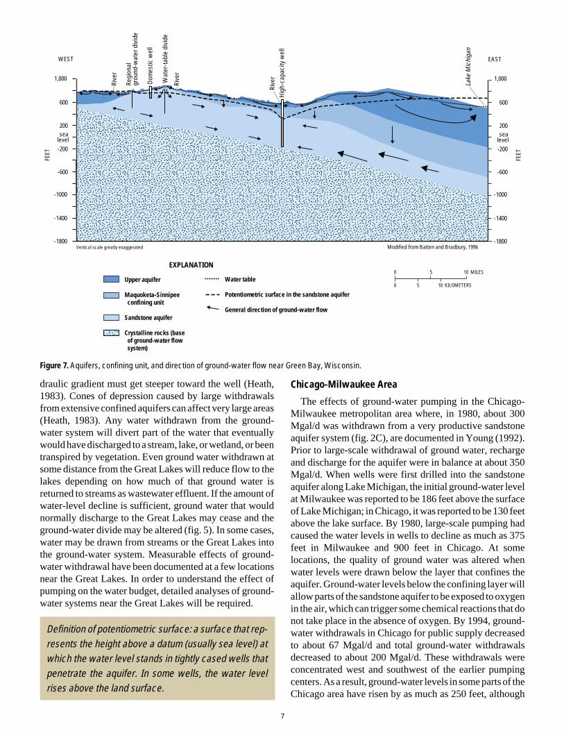
Figure 7. Aquifers, confining unit, and direction of ground-water flow near Green Bay, Wisconsin.
draulic gradient must get steeper toward the well (Heath,1983). Cones of depression caused by large withdrawalsfrom extensive confined aquifers can affect very large areas(Heath, 1983). Any water withdrawn from the ground-water system will divert part of the water that eventuallywould have discharged to a stream, lake, or wetland, or beentranspired by vegetation. Even ground water withdrawn atsome distance from the Great Lakes will reduce flow to thelakes depending on how much of that ground water isreturned to streams as wastewater effluent. If the amount ofwater-level decline is sufficient, ground water that wouldnormally discharge to the Great Lakes may cease and theground-water divide may be altered (fig. 5). In some cases,water may be drawn from streams or the Great Lakes intothe ground-water system. Measurable effects of ground-water withdrawal have been documented at a few locationsnear the Great Lakes. In order to understand the effect ofpumping on the water budget, detailed analyses of ground-water systems near the Great Lakes will be required.
Definition of potentiometric surface: a surface that rep-resents the height above a datum (usually sea level) atwhich the water level stands in tightly cased wells thatpenetrate the aquifer. In some wells, the water levelrises above the land surface.
Chicago-Milwaukee Area
The effects of ground-water pumping in the Chicago-Milwaukee metropolitan area where, in 1980, about 300Mgal/d was withdrawn from a very productive sandstoneaquifer system (fig. 2C), are documented in Young (1992).Prior to large-scale withdrawal of ground water, rechargeand discharge for the aquifer were in balance at about 350Mgal/d. When wells were first drilled into the sandstoneaquifer along Lake Michigan, the initial ground-water levelat Milwaukee was reported to be 186 feet above the surfaceof Lake Michigan; in Chicago, it was reported to be 130 feetabove the lake surface. By 1980, large-scale pumping hadcaused the water levels in wells to decline as much as 375feet in Milwaukee and 900 feet in Chicago. At somelocations, the quality of ground water was altered whenwater levels were drawn below the layer that confines theaquifer. Ground-water levels below the confining layer willallow parts of the sandstone aquifer to be exposed to oxygenin the air, which can trigger some chemical reactions that donot take place in the absence of oxygen. By 1994, ground-water withdrawals in Chicago for public supply decreasedto about 67 Mgal/d and total ground-water withdrawalsdecreased to about 200 Mgal/d. These withdrawals wereconcentrated west and southwest of the earlier pumpingcenters. As a result, ground-water levels in some parts of theChicago area have risen by as much as 250 feet, although
EXPLANATION
Water table
Potentiometric surface in the sandstone aquifer
General direction of ground-water flow
Modified from Batten and Bradbury, 1996
FEET
WEST EAST
FEET
Vertical scale greatly exaggerated
Upper aquifer Maquoketa-Sinnipee confining unit
Sandstone aquifer
Crystalline rocks (base of ground-water flow system)
Lake
Mic
higa
n
Rive
r
Rive
r
Rive
r
Dom
estic
wel
l
High
-cap
acity
wel
l
Regi
onal
gr
ound
-wat
er d
ivid
e
Wat
er-ta
ble
divi
de
1,000
600
200
-200
-600
-1000
-1400
-1800
sealevel
1,000
600
200
-200
-600
-1000
-1400
-1800
sealevel
10 MILES0 5
0 5 10 KILOMETERS

8
Figure 8. Simulated potentiometric surface in the sandstone aquifer, northeastern Wisconsin, (A) in 1957; and (B) in 1990 (from Conlon, 1998).
levels continue to decline in the southwestern Chicago(Visocky, 1997) and the Milwaukee metropolitan areas.
Computer simulations of the sandstone aquifer systemindicate that, for 1980 pumping conditions, depressed wa-ter levels in the system have caused additional recharge andhave resulted in a reduction of natural discharge (Young,1992). To keep withdrawals in balance with recharge anddischarge, for 1980 pumping rates, water was withdrawnfrom storage in the aquifer system thus accounting for lowerground-water levels. As a result, in 1980, the ground-waterdivide in the aquifer system was displaced, in some places,about 50 miles west of its original (pre-pumping) position(fig. 6). The rates of recharge, discharge and removal fromstorage will vary depending on pumping rates, hydraulicproperties of the aquifer and confining units, and sources ofwater. The hydrologic system is further complicated by thefact that most effluent from ground-water withdrawals inthe Chicago area is discharged to the Mississippi RiverBasin via the Chicago Ship and Sanitary Canal—one of thefew places where water is diverted from the Great LakesBasin. However, the amount of ground-water diverted fromthe Great Lakes Basin by pumping is unknown becausesome of the water captured by pumping is recharged to theaquifer or removed from storage in the aquifer west of the
surface-water divide. These sources of water need to bemore accurately quantified in order to assess whether, on anet basis, water is being diverted from the Great Lakes byground-water withdrawals.
Green Bay-Fox River Area
The sandstone aquifer also is used as a water-supplysource in the Green Bay-Fox River area of Wisconsin. Adepiction of the potentiometric surface for the aquiferindicates that water-level declines of as much as 300 feethave occurred (fig. 7). The depressed water levels weredeep enough in 1957 (fig. 8A) that the city of Green Baybegan pumping water from Lake Michigan to supplementground-water sources. Withdrawals of ground water werereduced, so that by 1990, ground-water levels had risen byabout 100 feet in Green Bay (fig. 8B); levels decreased tothe south, however, because of increases in ground-waterwithdrawals by outlying communities.
800
800
700
700
700700
500
900
600
600600
800
88˚
89˚
44˚
45˚
Sandstoneaquiferabsent
800
Fox
River
Wol
fRiv
er
Fox
Rive
r
800
800
800
700
700
700
700
500
900900
600
600
800
88˚
89˚
44˚
45˚
Sandstoneaquiferabsent
20 MILES
20 KILOMETERS
0 10
100
800 Potentiometric contour—Shows line of equal simulatedwater-level altitude. Interval is100 feet. Datum is sea level
EXPLANATION
Ground-water divide
Base composited from USGS digital line graphs and other digitized information.
Fox
River
Wol
fRiv
er
Fox
Rive
r
600
Green
Bay
Green
Bay
A. B.
400
Toledo, Ohio Area
The Toledo, Ohio metropolitan area obtains groundwater from wells open to the carbonate aquifer and fromquarry dewatering near Lake Erie. Pumping has lowered

9
Figure 9. Potentiometric surface for the carbonate aquifer near Toledo, Ohio, July 1986.
Figure 10. Approximate average waterbudget for Lake Michigan.
water levels in wells as much as 35 feet below the averagelevel of Lake Erie (fig. 9). In addition, pumping has inducedwater from Lake Erie into the ground-water system andintercepted water that would have discharged from theground-water system to Lake Erie (Breen, 1989; Eberts andGeorge, in press; and Eberts, 1999). Although water-leveldata indicate that these interactions are taking place, theamounts of water being induced from the lake and inter-cepted by the pumping have not been quantified.
Irrigation throughout the Great Lakes watershed
Irrigation is the largest consumptive use of water in theGreat Lakes watershed, and ground-water sources contrib-ute about half of the water used for irrigation. In areaswhere surface-water sources are not readily available, it islikely that ground water will be the water source if newirrigation systems are installed.
610
600 590
580570 560 550
540
550 540
530
550
550
540
540
560570
580
590
570580
590
600
61062
0
630
640
600 580
640620600580
640
Potentiometric contour—Shows altitude at which water would stand in tightly-cased wells; dashed where approximate. Interval is 10 and 20 feet. Datum is sea level.
Quarry—Shows location of carbonate rock quarry.
Well
[Average lake level approximately 572 feet above sea level]
EXPLANATION590590
0 2 4
0 2 4
MILES
KILOMETERS
TOLEDO
Source: Breen, 1989
Lake Erie
83°45'83°30'
41°37'30"
Lake Michigan (values in cubic feet per second)
53,000
Prec
ipita
tion
on la
kePr
ecip
itatio
n on
lake
Prec
ipita
tion
on la
ke
Dire
ct s
urfa
ce-w
ater
runo
ffDi
rect
sur
face
-wat
er ru
noff
Dire
ct s
urfa
ce-w
ater
runo
ff
8,800
Grou
nd-w
ater
dis
char
ge to
stre
ams
ente
ring
the
lake
Grou
nd-w
ater
dis
char
ge to
stre
ams
ente
ring
the
lake
Grou
nd-w
ater
dis
char
ge to
stre
ams
ente
ring
the
lake
32,000
Dire
ct g
roun
d-w
ater
dis
char
ge to
the
lake
Dire
ct g
roun
d-w
ater
dis
char
ge to
the
lake
Dire
ct g
roun
d-w
ater
dis
char
ge to
the
lake
2,700
Dive
rsio
ns in
to L
ake
Mic
higa
nDi
vers
ions
into
Lak
e M
ichi
gan
Dive
rsio
ns in
to L
ake
Mic
higa
n
50
Retu
rn fl
ows
from
wat
er u
sers
Retu
rn fl
ows
from
wat
er u
sers
Retu
rn fl
ows
from
wat
er u
sers
6,000a
Evap
orat
ion
from
the
lake
Evap
orat
ion
from
the
lake
Evap
orat
ion
from
the
lake
41,000
Outfl
ow to
Lak
e Hu
ron
Outfl
ow to
Lak
e Hu
ron
Outfl
ow to
Lak
e Hu
ron
52,000
Surfa
ce-w
ater
with
draw
als
from
the
lake
Surfa
ce-w
ater
with
draw
als
from
the
lake
Surfa
ce-w
ater
with
draw
als
from
the
lake
7,500b
Grou
nd-w
ater
with
draw
als
from
with
in th
e ba
sin
Grou
nd-w
ater
with
draw
als
from
with
in th
e ba
sin
Grou
nd-w
ater
with
draw
als
from
with
in th
e ba
sin
2,100a Return flow is reduced by 3,200 ft3/s that is diverted out of the basin at Chicago, Ill.b Withdrawals for power plant cooling not included
10
Figure 11. Average ground-water and surface-runoff components of selected watersheds in the U.S. portion of the Great Lakes Basin (fromHoltschlag and Nicholas, 1998).
Ground-water and surface-water interactions
“Surface water commonly is hydraulically connected toground water, but the interactions are difficult to ob-serve and measure and commonly have been ignored inwater management considerations and policies. Manynatural processes and human activities affect the inter-actions of ground water and surface water.”
—Winter and others, 1998
Streams interact with ground water in three basic ways:they gain water from inflow of ground water through thestreambed, they lose water to ground water by outflowthrough the streambed, and they do both, gaining in somereaches and losing in others (Winter and others, 1998). Forground water to discharge into a stream channel, thealtitude of the water table in the vicinity of the stream mustbe higher than the altitude of the stream-water surface.Conversely, for water in a stream or lake to flow into theground, the altitude of the water table in the vicinity of thestream must be lower than the altitude of the stream-watersurface. The complexity of these interactions may varyfrom stream to stream as well as over time.
“In recognition of the frequent and pervasive interactionbetween groundwater and surface water and the virtualimpossibility of distinguishing between them in someinstances, the governments of Canada and the UnitedStates should apply the precautionary principle withrespect to removals and consumptive use of groundwa-ter in the Basin.”
—Interim IJC Report Recommendation V
Ground-water flow into the Great Lakes
L a k e S u p e r i o r
Lake
Mic
hi g
an
L a k eH u r o n
L a k eE r i e
GeorgianBay
Average ground-water component of streamflow, (in percent)
EXPLANATION
20 to 39
40 to 59
60 to 79
80 to 99
Ground water
Surface runoff65
35
LakeSuperior
LakeHuron
Lake Ontario
LakeMichigan
LakeErie
21
79
7525
7228
6535
52 48
Average ground-water and surface-runoff components of streamflow, in percent
Lake Ontario
“Groundwater is important to the Great Lakes eco-system…”
—Interim IJC Report, Page 5
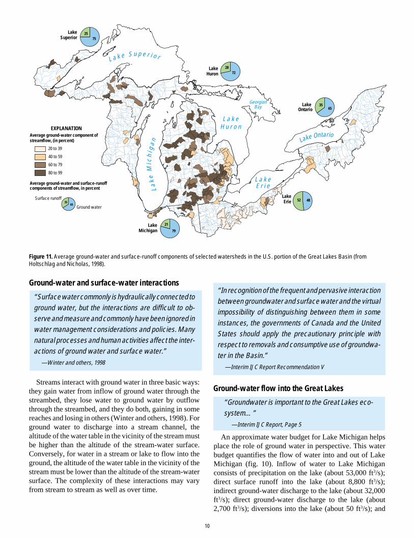
An approximate water budget for Lake Michigan helpsplace the role of ground water in perspective. This waterbudget quantifies the flow of water into and out of LakeMichigan (fig. 10). Inflow of water to Lake Michiganconsists of precipitation on the lake (about 53,000 ft3/s);direct surface runoff into the lake (about 8,800 ft3/s);indirect ground-water discharge to the lake (about 32,000ft3/s); direct ground-water discharge to the lake (about2,700 ft3/s); diversions into the lake (about 50 ft3/s); and

11
return flows into the lake from water users (about 6,000 ft3/s). Outflow of water from Lake Michigan consists ofevaporation from the lake surface (about 41,000 ft3/s);outflow from Lake Michigan to Lake Huron (about 52,000ft3/s); surface-water withdrawals from the lake (about 7,500ft3/s); and ground-water withdrawals in the watershed (about2,100 ft3/s) (Croley and Hunter, 1994; written commun.,Great Lakes Commission; Holtschlag and Nicholas, 1998;and Grannemann and Weaver, 1999). Although small incomparison to the amount of water in storage in the GreatLakes, ground water directly and indirectly contributesabout 80 percent of the water flowing from the watershedinto Lake Michigan. On the basis of these data, it is evidentthat ground water is an important component of the hydro-logic budget for the Great Lakes Region.
A relatively small amount of ground water flows directlyto the Great Lakes
The Great Lakes are in topographically low settings that,under natural flow conditions, causes them to function asdischarge areas or “sinks” for the ground-water-flow sys-tem. Most ground water that discharges directly into thelakes is believed to take place near the shore (Grannemannand Weaver, 1999). Of all the Great Lakes, Lake Michiganhas the largest amount of direct ground-water discharge(2,700 ft3/s) because it has more sand and gravel aquifersnear the shore than any of the other Great Lakes (Grann-emann and Weaver, 1999). Although this is a relatively lowinflow compared to the total streamflow into the lake fromland areas (41,200 ft3/s) (Croley and Hunter, 1994), it isnearly equal to the amount of water diverted from LakeMichigan through the Chicago Ship and Sanitary Canal(Oberg and Schmidt, 1996).
Ground water keeps streams flowing during periods oflow surface runoff
In most instances, the flow of a stream includes both asurface-water runoff component and a ground-water inflowcomponent. The fraction of total streamflow that originatedfrom ground water must be known to analyze and under-stand the interaction between surface water and groundwater in the stream. Holtschlag and Nicholas (1998) used amethod called “hydrograph separation” to estimate theamount of ground water in the total streamflow that dis-charges to the Great Lakes. They call this quantity of water“indirect ground-water discharge” to the lakes. Prior to thisstudy, indirect ground-water discharge was not explicitlyconsidered in estimates of Great Lakes Basin water supply.Instead, it was incorporated into the streamflow componentof the supply. Surface runoff is a short-term component offlow that results from precipitation moving overland to astream without percolating into an aquifer. Ground-waterdischarge is a long-term, persistent component that resultsfrom that part of precipitation that infiltrates into the soil,
percolates into an aquifer, and then flows to a stream.Although Holtschlag and Nicholas (1998) used data from
195 streamgaging stations in the watershed for their analy-sis, the combined drainage areas to these stations coveredonly 13.6 percent of the total drainage area of the GreatLakes Basin. These results were extended to the entire basinby assuming that the average ground-water component ofstreamflow estimated for the ungaged streams is about thesame as that estimated for gaged streams in the basin. Usingthis approach Holtschlag and Nicholas estimated that theaverage ground-water component of streamflow rangesfrom 48 percent for Lake Erie to 79 percent for LakeMichigan (fig. 11).
Ground water, wetlands, and stream ecology
Ground water and wetlands
“Similar to streams and lakes, wetlands can receiveground-water inflow, recharge ground water, or do both.”
—Winter and others, 1998
Wetlands, once perceived as worthless land, are nowrecognized as a necessary component of a vital landscape(Hunt, 1996). They are often considered the “kidneys of thelandscape” because of their role in mitigating and filteringthe effects of human activity on water resources in thewatershed. Wetland functions have been shown to includestorm and floodwater retention, shoreline protection, andwater-quality improvement. Wetlands also provide wild-life habitat. More than one-third of endangered species inthe United States are associated with wetlands even thoughwetlands comprise less than five percent of the landscape.Vast areas of wetland acreage —more than 50 percent in theUnited States, and more than 95 percent in some states thatborder the Great Lakes—have been destroyed, modified, orconverted to other uses since presettlement time. Althoughthe effects of these losses are beginning to be understood,more study is needed to improve our knowledge about therole of these important wetland systems.
Wetland hydrology is widely recognized as the primaryeffect on wetland ecology, development, and persistence.An understanding of the hydrology is essential to identifyand quantify wetland functions and processes. For ex-ample, ground-water flow has been shown to be importantfor the physical and chemical environment of other aquaticsystems because the amount of dissolved solids carried byground water is typically much higher than that carried bysurface water. Thus, ground water can have a profoundeffect on the acid susceptibility and nutrient status of thewetland (Hunt and others, 1997). It is widely recognizedthat linkages between water-budget components and wet-lands are not well known, due, in large part, to poorunderstanding of how ground water flows into and out ofwetlands.

12
though the amount of ground water pumped in the region issmall compared to the total amount of water present, groundwater is an important source of public-water supply as wellas an important source of supply for industrial, agricultural,and domestic needs. Less clearly understood, however, isthe relation between the amount of streamflow dischargingto the Great Lakes and the large portion of that flow thatoriginates as ground water. The implications of this under-standing for water- and land-use practices and, in turn, theireffects on water quantity and quality, have not been fullyincorporated into a policy framework. To help includeinformation about the implications of the role that groundwater plays in addressing regional water issues, a compre-hensive analysis of indirect ground-water discharge to theGreat Lakes is needed.
Direct ground-water discharge to the Great Lakes is nota large factor in water-budget analyses for the Great Lakes.Locally, however, direct ground-water discharge to theGreat Lakes may be important, even though the rates andplaces of discharge are not well known. A long-term evalu-ation of direct ground-water discharge to the Great Lakeswould help place this hydrologic process in proper perspec-tive. Near-shore areas with high rates of direct ground-water discharge may provide valuable habitat for aquaticorganisms.
• Issues related to the interaction of ground water andsurface water
Withdrawal of ground water removes that water from thewatershed when it is consumptively used or when the returnflow is discharged to another drainage basin. Under thesecircumstances, pumping ground water constitutes a diver-sion of Great Lakes water. Alternatively, ground-waterwithdrawal could have the opposite effect of divertingground-water flow into the watershed by altering the ground-water divides. In particular, as withdrawals associated withurban expansion increase, more accurate data on the amountand effects of ground-water use need to be collected. Dataon the amounts of ground water pumped both within thewatershed and outside, but near the watershed boundariesneeds to be collected and evaluated for potential diversionof water to or from the Great Lakes. It is currently thoughtthat both irrigation and ground-water withdrawals near thewatershed boundaries constitute relatively small amountsof water; however, both rapidly changing farming practicesand rapidly expanding urban communities could alter theseamounts in a relatively short timeframe, especially duringdrought periods. At present, the effects of ground-waterwithdrawals have been quantified in detail at only a fewurban locations.
In addition to quantifying the amount of water pumpedout of aquifers, it is also important to improve our knowl-edge of the amount of water that is recharging them.Ground-water recharge rates estimated in earlier studies
While problems associated with ignoring ground water inwater-budget analyses are well known (Winter, 1981),traditional hydrologic analyses have had limited success inshowing the linkage of ground water to physical and chemi-cal hydrology of wetlands. Previous work on ground waterin wetlands has often relied on methods used in aquifer-scale studies, such as widely spaced sample intervals andaquifer tests. Recently, non-traditional investigations ofwetlands have shown substantial complexity within wet-land hydrologic systems (Harvey and Nuttle, 1995; Huntand others, 1996). Moreover, this research is showing thatground water has profound effects on the physical andchemical environment of a wetland (Hunt and others, 1999).
Ground water provides refuge for aquatic organisms
Ground-water discharge to streams may help provideimportant habitat for aquatic organisms, including fish. Inaddition, because ground-water temperatures are nearlyconstant throughout the year, stream reaches with relativelylarge amounts of ground-water discharge can provide ref-uge to organisms from heat in summer and from cold inwinter. For example, some stream reaches in the regionremain unfrozen even though air temperatures are wellbelow 32o Fahrenheit. Other possible benefits to the survivalof aquatic organisms related to ground-water discharge tostreams include increasing concentrations of dissolved oxy-gen; adding small amounts of nutrients that are essential tothe health of organisms; providing cold pockets of water insummer; and maintaining streamflow during dry periods.
Summary and conclusions
Ground water is a major natural resource in the GreatLakes Region because it indirectly contributes more than 50percent of the stream discharge to the Great Lakes. Inaddition, ground water is the source of drinking water formillions of people in the region, is an important source ofsupply for agriculture and many industries, and provides arelatively uniform supply of water in some ecologicallysensitive areas to sustain plant and animal species. There-fore, to improve our understanding of water-resourcesissues in the Great Lakes Region, it is important to have abetter understanding of the role that ground water plays inthe overall hydrologic system of the lakes.
The main ground-water resources issues in the GreatLakes Region are related to the amount of ground water, theinteraction of ground water and surface water, changes inground-water quality as development expands, and ecosys-tem health related to quantity and quality of water.
• Issues related to the amount of ground water
Although the amount of water in the Great Lakes Regionis vast, issues related to relatively small quantities of waterare being raised more and more often. For example, even

13
cover only a small part of the Great Lakes Region. Acomprehensive study of ground-water recharge rates forthe entire watershed is needed to more completely deter-mine the role of ground water in the hydrologic budget ofthe Great Lakes.
• Issues related to changes in ground-water quality asdevelopment expands
Ground-water quality is as important as quantity for mostwater uses. As ground-water development proceeds, thepossibility of altering the quality of ground water increases.The quality of ground water can be altered when waterlevels are drawn below the layer that confines the aquifer orby inducing water of lesser quality into an aquifer. Manylocal studies of these problems have been conducted, butfew regional-scale analyses of changes in ground-waterquality as a result of ground-water development have beendone.
• Issues related to ecosystem health and quantity andquality of ground water
Ground water is essential to maintain wetlands and toprovide healthy habitat for other aquatic systems. Wetlandhydrology is widely recognized as the primary influence onwetland ecology, development, and persistence, and infor-mation about hydrology is essential to understanding andquantifying wetland functions and processes. Studies of therole of ground water in selected wetlands in a range ofphysiographic settings throughout the Great Lakes water-shed are needed to more fully understand the role ofwetlands in the Great Lakes Region.
Conlon, T.D., 1998, Hydrogeology and simulation of ground-water flow in thesandstone aquifer, northeastern Wisconsin: U.S. Geological Survey Water-Resources Investigations Report 97-4096, p. 30–31.
Croley, T.E., II, and Hunter, T.S., 1994, Great Lakes monthly hydrologic data:National Oceanic and Atmospheric Administration Technical Report ERLGLERL-83, 84 p.
Eberts, S.M., 1999, Water levels and ground-water discharge, Regional AquiferSystem of the Midwestern Basins and Arches Region, in parts of Indiana, Ohio,Illinois, and Michigan: U.S. Geological Survey Hydrologic Atlas HA 725, 3maps.
Eberts, S.M., and George, L.L., in press, Regional ground-water flow and geochem-istry in the Midwestern Basins and Arches Aquifer System in parts of Indiana,Ohio, Illinois, and Michigan: U.S. Geological Survey Professional Paper 1423-C.
Government of Canada and U.S. Environmental Protection Agency, 1995, TheGreat Lakes—An Environmental Atlas and Resource Book, EPA 905-B-95-001, 46 p.
Grannemann, N.G., and Weaver, T.L., 1999, An annotated bibliography of selectedreferences on the estimated rates of direct ground-water discharge to the GreatLakes: U.S. Geological Survey Water-Resources Investigations Report 98-4039, 22 p.
Great Lakes Basin Commission, 1975, Great Lakes Basin Framework Study,Appendix 3, Geology and Ground Water, 152 p.
Harvey, J.W., and Nuttle, K.W., 1995, Fluxes of water and solutes in a coastalwetland sediment: Journal of Hydrology, vol. 164, p. 109–125.
Heath, R.C., 1983, Basic ground-water hydrology: U.S. Geological Survey Water-Supply Paper 2220, 84 p.
Holtschlag, D.J., 1997, A generalized estimate of ground-water recharge rates in theLower Peninsula of Michigan: U.S. Geological Survey Water-Supply Paper2437, 37 p.
Holtschlag, D.J., and Nicholas, J.R., 1998, Indirect ground-water discharge to theGreat Lakes: U.S. Geological Survey, Open-File Report 98-579, 25 p.
Hunt, R.J., 1996, Do created wetlands replace wetlands that are destroyed?, U.S.Geological Survey Fact Sheet, FS-246-96, 4 p.
Hunt, R.J., Krabbenhoft, D.P., and Anderson, M.P., 1996, Groundwater inflowmeasurements in wetland systems: Water Resources Research, vol. 32,p. 495–507.
Hunt, R.J., Krabbenhoft, D.P., and Anderson, M.P., 1997, Assessinghydrogeochemical heterogeneity in natural and constructed wetlands: Bio-geochemistry, vol. 39, p. 271–293.
Hunt, R.J., Walker, J.F., and Krabbenhoft, D.P., 1999, Characterizing hydrologyand the importance of ground-water discharge in natural and constructedwetlands: Wetlands, vol. 19(2), p. 458–472.
International Joint Commission, 1999, Protection of the waters of the Great Lakes,Interim Report to the Governments of Canada and the United States, 40 p.
Oberg, K.A., and Schmidt, A.R., 1996, Measurement of leakage from LakeMichigan through three control structures near Chicago, Illinois, April– October1993: U.S. Geological Survey Water-Resources Investigations Report 94-4112,48 p.
Passero, R.N., Straw, W.T., and Schmaltz, L.J., 1981, Hydrogeologic atlas ofMichigan: Western Michigan University, College of Arts and Sciences, Depart-ment of Geology, 35 plates.
Solley, W.B., Pierce, R.R., and Perlman, H.A., 1998, Estimated use of water in theUnited States in 1995: U.S. Geological Survey Circular 1200, 71 p.
Sun, R.J., Weeks, J.B., and Grubb, H.F., 1997, Bibliography of Regional Aquifer-System Analysis Program of the U.S. Geological Survey, 1978–96: U.S.Geological Survey Water-Resources Investigations Report 97-4074, 63 p.
Visocky, A.P., 1997, Water-level trends and pumpage in the deep bedrock aquifersin the Chicago region, 1991–1995: Illinois State Water Survey Circular 182, 44p.
Winter, T.C., 1981, Uncertainties in estimating the water balance of lakes: WaterResources Bulletin: vol. 17, p. 82–115.
Winter, T.C., Harvey, J.W., Franke, O.L., and Alley, W.M., 1998, Ground water andsurface water a single resource: U.S. Geological Survey Circular 1139,77 p.
Young, H.L., 1992, Summary of ground-water hydrology of the Cambrian-Ordovi-cian aquifer system in the northern Midwest, United States: U.S. GeologicalSurvey Professional Paper 1405-A, 55 p.
References
Alley, W.M., Reilly, T.E., and Franke, O.L., 1999, Sustainability of ground-waterresources: U.S. Geological Survey Circular 1186, 79 p.
Avery, C., 1995, Reversal of declining ground-water levels in the Chicago area: U.S.Geological Survey Fact Sheet FS-222-95, 2 p.
Batten, W.G., and Bradbury, K.R., 1996, Regional ground-water flow systembetween the Wolf and Fox Rivers near Green Bay, Wisconsin: WisconsinGeological and Natural History Survey Information Circular 75, 28 p.
Bhagwat, S.B., and Berg, R.C., 1991, Benefits and costs of geologic mappingprograms in Illinois: Case study of Boone and Winnebago Counties and itsstatewide applicability: Illinois State Geological Survey Circular 549, 40 p.
Bleuer, N.K., Melhorn, W.N., Steen, W.J., and Bruns, T.M., 1991, Aquifer systemsof the buried Marion-Mahomet trunk valley (Lafayette bedrock valley system)of Indiana, in Melhorn, W.N., and Kempton, J.P., eds., Geology and hydrogeologyof the Teays-Mahomet bedrock valley systems: Geological Society of AmericaSpecial Paper 258, p. 79–89.
Breen, K.J., 1989, Potentiometric-surface map of the Carbonate Aquifer in Silurianand Devonian rocks, Lucas, Sandusky, and Wood Counties, Northwestern Ohio,July 1986: U.S. Geological Survey Water-Resources Investigations Report 88-4144, 1 map.
Casey, George D., 1996, Hydrogeologic framework of the Midwestern Basins andArches Region in parts of Indiana, Ohio, Michigan, and Illinois: U.S. GeologicalSurvey Professional Paper 1423-B, 46 p.
Central Great Lakes Geologic Mapping Coalition, 1999, Sustainable growth inAmerica’s heartland—3-D geologic maps as the foundation: U.S. GeologicalSurvey Circular 1190, 17 p.

14
Information
For more information please contact:
Norman GrannemannGround-Water Resources Program CoordinatorUSGS, Water Resources Division6520 Mercantile Way, Suite 5Lansing, MI 48911phone: (517) 887-8936email: [email protected]://water.usgs.gov/ogw/GWRP.html
Authors:
Norman G. GrannemannRandall J. HuntJames R. NicholasThomas E. ReillyThomas C. Winter
Layout and illustrations: Michelle M. Greenwood, Aaron T. Konkol, and Robyn L. Trentham
This report was cooperatively funded by the International Joint Commission and the U.S. Geological Survey.
Printed on recycled paper