the imperial government of iran and the government of … agreement was ratified by iran on march 15...
TRANSCRIPT


2
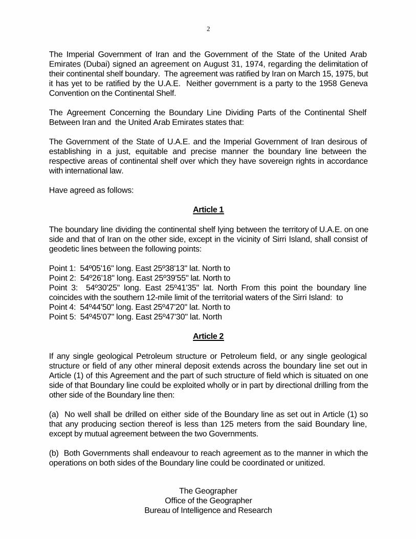
The Imperial Government of Iran and the Government of the State of the United Arab Emirates (Dubai) signed an agreement on August 31, 1974, regarding the delimitation of their continental shelf boundary. The agreement was ratified by Iran on March 15, 1975, but it has yet to be ratified by the U.A.E. Neither government is a party to the 1958 Geneva Convention on the Continental Shelf.
The Agreement Concerning the Boundary Line Dividing Parts of the Continental Shelf Between Iran and the United Arab Emirates states that:
The Government of the State of U.A.E. and the Imperial Government of Iran desirous of establishing in a just, equitable and precise manner the boundary line between the respective areas of continental shelf over which they have sovereign rights in accordance with international law.
Have agreed as follows:
Article 1
The boundary line dividing the continental shelf lying between the territory of U.A.E. on one side and that of Iran on the other side, except in the vicinity of Sirri Island, shall consist of geodetic lines between the following points:
Point 1: 54º05'16" long. East 25º38'13" lat. North to Point 2: 54º26'18" long. East 25º39'55" lat. North to Point 3: 54º30'25" long. East 25º41'35" lat. North From this point the boundary line coincides with the southern 12-mile limit of the territorial waters of the Sirri Island: to Point 4: 54º44'50" long. East 25º47'20" lat. North to Point 5: 54º45'07" long. East 25º47'30" lat. North
Article 2
If any single geological Petroleum structure or Petroleum field, or any single geological structure or field of any other mineral deposit extends across the boundary line set out in Article (1) of this Agreement and the part of such structure of field which is situated on one side of that Boundary line could be exploited wholly or in part by directional drilling from the other side of the Boundary line then:
(a) No well shall be drilled on either side of the Boundary line as set out in Article (1) so that any producing section thereof is less than 125 meters from the said Boundary line, except by mutual agreement between the two Governments.
(b) Both Governments shall endeavour to reach agreement as to the manner in which the operations on both sides of the Boundary line could be coordinated or unitized.
The Geographer Office of the Geographer
Bureau of Intelligence and Research

3
Article 3
The Boundary line referred to in Article (1) herein has been illustrated on the British Admiralty Chart No: 2837 which is annexed to this Agreement.
Article 4
Nothing in this Agreement shall affect the status of the superajacent [sic] waters or airspace above any party of the Continental Shelf.
Article 5
(a) This Agreement shall be ratified and the instruments of ratification shall be exchanged at …………….as soon as possible.
(b) This Agreement shall enter into force on the date of the exchange of instruments of ratification.
In witness thereof the undersigned being duly authorized by their respective Governments, have signed the present Agreement.
Done in duplicate at Tehran the 24 Rajah 1394 corresponding to the 13 August 1974 in the Arabic, Persian, and English languages, all texts being equally authoritative.
For the State of U.A.E.
For the Imperial Government of Iran
ANALYSIS
The continental shelf boundary between Iran and the U.A.E. was plotted on U.S. Naval Oceanographic Charts 62390 and 62400,
The boundary extends for a distance of 39.25 nautical miles and it has five turning or terminal points. The distances between points 1-2, 2-3, 3-4, and 4-5 are 19.18 n. miles, 4.60 n. miles, 14.29 n. miles, and 1.18 n. miles respectively. The depth of the water in this area of the Persian Gulf is approximately 30 fathoms (54.9 meters).
The boundary is not based on the equidistance principle; from four of the five turning or terminal points the boundary is nearer to the Irani Island of Sirri than to any U.A.E. territory. From point 3-4 the shelf boundary coincides with Sirri's 12-nautical-mile territorial sea (the .22 n. mile discrepancy found when measuring the territorial sea--refer to the table--may be a result of the particular chart or projection used).

4
Even though the Dubai Government was the principal emirate involved in this treaty, most of the boundary is closer to the coasts of other emirates. The U.A.E. territory closest to points 1 and 2 is the island of Sir Abu Nu ' ayr which belongs to Sharjah. The island of Abu Musa, closest to points 3, 4, and 5 is currently in dispute between Iran and Sharjah. Disregarding Abu Musa, points 3 and 5 are closest to Sharjah (30.79 and 42.30 n. miles respectively) while point 4 is closest to Dubai (42.48 n. miles). The continental shelf boundary does not coincide with the lateral limits of Dubai's legal continental shelf. The eastward limit of Dubai's legal shelf extends at a 310.5º azimuth from the Abu Hayl Peninsula to approximately the location of point 4 on the Iran-U.A.E. shelf boundary. The westward limit of Dubai's legal shelf extends at a 314.5º azimuth from the coast near Ra 's Hasan to a point approximately 1.9 nautical miles east from point 1 on the Iran-U.A.E. boundary.

5
PHYSICAL CHARACTERISTICS OF THE IRAN-U.A.E. CONTINENTAL SHELF BOUNDARY
Terminal Distance Iran Territory Distance, Land to U.A.E. Territory or Between Boundary Point
Turning Points (n.m.) points (n.m.)
1 Sirri 27.04 24.70 Sir Abu Nu'ayr (Sharjah)
19.18
2 Sirri 14.29 27.66 Sir Abu Nu'ayr (Sharjah)
4.60
3 Sirri 12.22 30.79 Sir Abu Nu'ayr (Sharjah)
29.00 Abu Musa (Disputed)
14.29
4 Sirri 12.22 42.48 Mainland (Dubai)
14.87 Abu Musa (Disputed)
1.18
5 Sirri 12.34 42.30 Mainland (Sharjah)
14.54 Abu Musa (Disputed)
