the impacts of urban sprawl on soil sealing of feira de...
TRANSCRIPT

Journal of Geography and Earth Sciences December 2016, Vol. 4, No. 2, pp. 31-50
ISSN 2334-2447 (Print) 2334-2455 (Online) Copyright © The Author(s). All Rights Reserved.
Published by American Research Institute for Policy Development DOI: 10.15640/jges.v4n2a3
URL: https://doi.org/10.15640/jges.v4n2a3
The impacts of urban sprawl on soil sealing of Feira de Santana through comparative analysis of satellite image classification
Caio Macieira de Almeida Aguilar1 & Rosângela Leal Santos2
Abstract
Soil sealing in large urban centers and their effects on the environment and society is increasingly present in cities. This study aims to analyze the soil sealing process of Feira de Santana due to urban expansion. The Bahian municipality is the second largest population in the state, has a relatively flat topography and lacks studies to guide urban planning to promote environmental education and the implementation of urban sanitation. The collection of satellite images of the urban area of the city was utilized for dereferencing, through segmentation and classification of the images and a statistical analysis of the data was accomplished through spatial analysis. The modeling and image processing were performed by GIS SPRING software. This research sought to portray the area’s most affected by the waterproofing of the soil and other areas within the city that are in the process of waterproofing due to urban growth for the classification of satellite images..
Keywords: Waterproofing, GIS, Urban Growth, Classification, Feira de Santana 1. Introduction
The municipality of Feira de Santana, the second largest city in the State of Bahia, has been suffering an accelerated process of urban expansion. Despite the rapid growth in population, the replacement of permeable pavements (interlocked blocks, parallel, etc.) and soil with waterproof flooring (such as concrete and asphalt) and the increasing development of buildings has transformed the soil to become totally impermeable.
1 Degree in Civil Engineering from Universidade Estadual de Feira de Santana - UEFS/DTEC, Postal Code 252 - 44036-900 – Feira de Santana - BA, Brazil. ([email protected]) 2 Assistant Professor at the State University of Feira de Santana - UEFS/DTEC, Postal Code 252 - 44036-900 – Feira de Santana - BA, Brasil.

32 Journal of Geography and Earth Sciences, Vol. 4(2), December 2016
The main issue amongst the development of waterproofing the soil in the city, is that the topography of Feira de Santana is flat. As a result, this topography lacks a proper drainage system to sustain this urban transformation.
The tessellations used in urban centers alters significantly the dynamics of soil
infiltration, as such, the impact of the urbanization can produce a significant increase in the runoff coefficients of a basin (VENDRAME; LEE, 2005). These changes are also observed in the silting of the lacustrine system of Feira de Santana and the reduction of green areas. As the removal of vegetation cover creates vacancy for new developments, without adequate monitoring of the established functioning infrastructure, investment regarding rainwater management and minimal preservation of urban green areas are deplored.
Understand that, with the process of urbanization, the impacts on soil are
identified even though the landscape is not paved and resealed. That's because the soil exposed due to the removal of vegetation exposes albedo and reduces infiltration, because it comes to clay soils, which infiltration of water is minimal. Finally, because it comes, for example, from clay soils the water infiltration is minimal (SANTOS, 2008).
The city of Feira de Santana becomes a challenge to projects and urban
sanitation infrastructure development projects. Its location on such a planar landscape is in the midst of problems of soil sealing, with an ever-growing population through immigration promoted by investments in the region in the areas of education, trade and industry.
Remote sensing techniques were used to determine changes in land use and
land cover in urban areas for decision-making and landscape management (Yildiz and Doker, 2016). Thus, it is necessary to model the soil sealing level of the urban area of Feira de Santana through identification of different classes of urban land use, relating the level of waterproofing to urban land use classes and quantifying them.
1. Methodology
The urban space of Feira de Santana was modeled through the use of Rapid
Eye image with application of image classification (segmentation - Battacharya and maximum likelihood) and comparative techniques to identify the modifications of the systems of land use and soil cover.

Aguilar & Santos 33
According to the division of official neighborhoods of 2010, the urban region of Feira de Santana was bounded as the study area. Due to having an urban area with two scenes that were encompassed with mosaics which present a difference of color balancing (Figure 01), it was preferred to delete the additional scene on the left which correspond to a small extension of the urban area in order to avoid misinterpretations by the algorithms during the classification process. The current dynamic of the georeferencing was evaluated through fieldwork with characterization of the blocks of urban land where it was classified and categorized in to the different areas of the city in relation to classes of use and occupation of the soil used.
Sorting is the process of extracting information in images to recognize
patterns and homogeneous objects. From the choice of images, it was sought to assess the methods being employed to sort the images, which were more consistent with the objectives proposed. Of the different methods evaluated, two different techniques were chosen: one per pixel, maximum likelihood (MaxVer); and the other by regional categorization of targeting, the use of the algorithm to perform the classification of Bhattacharyya image segmented. The “pixel to pixel” classifiers are based only on spectral information that is separate for each pixel to find in homogeneous regions. The end result of a classification process is the digital image that is a map of classified pixels represented by graphic symbols or colors. Multispectral classification techniques that are “pixel to pixel” are the most common for the maximum likelihood (MAXVER), for being a robust method and very well described in the literature.
Figure 01: Rapid Eye Scenes with difference in contrasts. Colour composition
4-3-2 (RGB)

34 Journal of Geography and Earth Sciences, Vol. 4(2), December 2016
Another form of classification is through the classifiers for regions that use, in addition to spectral information of each “pixel”, the spatial information that involves the relationship between the “pixels” and their neighbors. These classifiers seek to simulate the behavior of a photo-interpreter in recognizing homogeneous areas of images based on spectral and spatial properties of images. The edge information is used initially to separate regions and the spatial and spectral properties will join areas with the same texture.
The first step to carry out the classification of regions is the generation of a
segmented image. Segmentation constitutes the first step of an object-oriented classification. However, the algorithm used is based on the similarity of pixels, taking into consideration the interior of objects by analyzing similar properties between the pixels, with the criterion methods of segmentation by regions, growth, and threshold detection of bowls, pyramids and clustering.
For the classification on the image segmentation algorithm used was the
Bhattacharyya, which uses the Bhattacharyya distance, which measures the similarity of two probability distributions.
2. Results and discussion
After several tests in the images using the preprocessing methods (registry,
filtering, highlighting, composition of bands and equalization of histograms), it was opted for the use of the image (spatial resolution of Rapid Eye, 5 m with 4 spectral bands - blue, green, red and near infrared - and a classification technique: a per pixel (maxver) and region (segmentation classification processing by the Batthacharya algorithm). The image Rapid Eye (17 June 2010) used is presented in Figure 02.
Figure 02: Rapid Eye Scene used at work. Colour composition 5-3-2 (RGB)

Aguilar & Santos 35
After a study of the region and the use of waterproofing, this presented 8 defined classes for training, based on the use and occupation of the soil, namely:
Urban 1 – Area of the city center, a denser, high concentration of buildings,
concrete and slab roofs, and streets paved. Little or no afforestation; Urban 2 – The area adjacent to the Urban1. Lower concentration of buildings.
Greater afforestation. Concrete slabs and ceramic roofs. Paved and cobbled paved streets;
Urban 3 – The peripheral area; predominance of ceramic roofs; houses with 1 or 2 floors; constructed in a smaller area than the area of the property, with existence of gardens and backyards; predominance of unpaved streets;
Water – Stone Horse Lake; River Bank; dams; urban ponds with water. Exposed soil – No noticeable vegetation and areas without coating of any
kind. Vegetation 1 – Dense vegetation on the banks of rivers and lakes. Vegetation 2 – Natural vegetation of caatinga. Vegetation 3 – Pastures.
Four clippings of images (samples) were collected in different points of the
city (Figure 03) by the field work that predominates one of the classes of soil use and occupation for sorting and comparison between the methods of classification and the reality on the spot.
The clippings of the RapidEye scene were removed from the Center regions
of Feira de Santana (local with densification of buildings), the Airport (peripheral region and in expansion), The Salgada pond – Noide Cerqueira Avenue (a new avenue and new vector of urban growth) and the new town (next to the ring and contour the middle too).
For the generation of segmented images, the attempt to find various
combinations of similarity and area were actualized, most of them were recognized through literature (PEREIRA and RIBEIRO, 2008; Cross and RIBERIRO, 2008; SOUTO, 2003; OLIVEIRA, ZEILHOFER, SANTOS, 2007). However, it is implied the use of a system of trial and error would find the best parameters for each image. The images were then converted through the SPRING software to be worked on 8 bit. As a result, 4 combinations of similarity of areas were realized, namely:

36 Journal of Geography and Earth Sciences, Vol. 4(2), December 2016
• Similarity of 8 and 12 area; • Similarity of 8 and 20 area; • Similarity of 12 and 20 area; • Similarity of 12 and 50 area. Figure 3 - Scene with local ID Rapid Eye of samples for sorting.
In Figure 4, the results for targeting with the classification through the
Bhattacharyya algorithm sample 1, correspond to the region of the Salgada pond in an urban area in Feira de Santana. In Figure 05, it shows the results of the maximum likelihood classification (MaxVer).
For the classifications presented in Figure 4, the one that best represented the
reality in the field was the segmentation with similarity of 12 and 20, as portrayed with better vegetation around the pond as well as the exposed soil in the peripheral and central areas of the cropping of the image. For the validation and measurement of accuracy of the results were used testing specimens. Was collected for each sample used for grading a test sample equivalent and made the comparison of the results.

Aguilar & Santos 37
Figure 4-Classification for segmentation with sample 1 of the Bhattacharyya algorithm. a) classification by similarity of segmentation 8 and 12; b) targeting 8 similarity rating and 20 area; c) classification by similarity d) segmentation
segmentation 12 similarity rating and 50 area; e) Legend class.
(a) (b)
(c) (d)

38 Journal of Geography and Earth Sciences, Vol. 4(2), December 2016
Figure 5- Sample 1 of the MaxVer rating.
Statistical results for each of the classifications were presented by obtaining
measuring using the SPRING software. In this report the value of the area was presented to each class, in which it was also the total for the classes for the polygons not classified beyond the total area of the active Information Plan.
In Table 1, the values are represented for the measurement of classes in
addition to their percentage in relation to the total area ranked by km² for the sorting by MaxVer and by regions according to the degree of similarity and work in segmentation.
For the statistical values that were carried out as described previously, it is
observed that the classification for the segmentation Bhattacharyya algorithm presented variations in relation to the classification of MaxVer from 5% to 10%, except for the classes Urban 3 and Exposed Soil which presented higher values. This is one of the difficulties of the work, whose values of Exposed Soil and Urban 02 confused, even with a contingency table with values above 95% degree of acceptance. These values of the classes presented a classification not expected because the spectral values of the pixels were very close.

Aguilar & Santos 39
In truth, as seen from Table 01-c the comparative analysis with test samples, since the image represented a better reality of the area and the predominance of Urban 03 (green area greater than 50% and unpaved streets) and Vegetation 03 (rangelands or undergrowth).
Table 1 – classes measured. a) classification by similarity of
segmentation 8 and 12; b) targeting 8 similarity rating and 20 area; c) classification by similarity of segmentation 12 and 20; d) classification by similarity of segmentation 12 and 50 area; e) MaxVer rating.
(a) (b)
(c) (d)
(e)
Classes de uso do solo Área (kmxkm) (%)Agua 0,548475 16%Vegetacao_1 0,385450 11%Vegetacao_2 0,258675 8%Vegetacao_3 0,305675 9%Urbano_1 0,241875 7%Urbano_2 0,837100 25%Urbano_3 0,681175 20%Solo_exposto 0,106650 3%Similaridade 8 - Área 12 3,365075 100%
Classes de uso do solo Área (kmxkm) (%)Agua 0,664775 19%Vegetacao_1 0,439650 13%Vegetacao_2 0,293925 9%Vegetacao_3 0,452250 13%Urbano_1 0,054725 2%Urbano_2 0,613550 18%Urbano_3 0,643600 19%Solo_exposto 0,264125 8%Similaridade 8 - Área 20 3,4266 100%
Classes de uso do solo Área (kmxkm) (%)Agua 0,58105 17%Vegetacao_1 0,67095 20%Vegetacao_2 0,33620 10%Vegetacao_3 0,38478 11%Urbano_1 0,03078 1%Urbano_2 0,54243 16%Urbano_3 0,65515 19%Solo_exposto 0,22778 7%Similaridade 12 - Área 20 3,4291 100%
Classes de uso do solo Área (kmxkm) (%)Agua 0,600175 10%Vegetacao_1 0,240800 4%Vegetacao_2 0,276150 5%Vegetacao_3 0,760275 13%Urbano_1 0,033425 1%Urbano_2 0,202100 3%Urbano_3 1,025150 17%Solo_exposto 2,920750 48%Similaridade 12 - Área 50 6,058825 100%
Classes de uso do solo Área (kmxkm) (%)Agua 0,519225 11%Vegetacao_1 0,145650 3%Vegetacao_2 0,540800 11%Vegetacao_3 0,467400 10%Urbano_1 0,000000 0%Urbano_2 1,176550 25%Urbano_3 1,890750 40%Solo_exposto 0,028875 1%MaxVer 4,76925 100%

40 Journal of Geography and Earth Sciences, Vol. 4(2), December 2016
The results for targeting with the classification by the Bhattacharyya algorithm (figure 06) sample 2, corresponded to the region of the neighborhood new town on the edge of the ring and contour figure 07 the result to the maximum likelihood classification (MaxVer) are expressed below.
For the classifications (Figure 06), the one that best represented the reality in
the field was the segmentation with similarity of 12 and 20, as it best illustrated urban classes properly with reality as well as the vegetation and the exposed soil. Similarly the first sample, for validation and choosing the best classification, samples were taken for each test sample used in the classification. In targeting with similarity of 8 and 20 soil exposed area was confused with the Urban 2 class.
Figure 06-Segmentation classification with sample 02 Bhattacharyya
algorithm. a) classification by similarity of segmentation 8 and 12; b) targeting 8 similarity rating and 20 area; c) classification by similarity of segmentation 12 and 20; d) classification by similarity of segmentation 12 and 50 area; e) Legend class.
(a) (b)
(c) (d)
(e)

Aguilar & Santos 41
Figure 7- Sample 2 Max Ver rating.
In Table 02, the values are represented for classes plus their percentage in
relation to total area ranked km ² to sorting by MaxVer and by Targeting according to the degree of similarity and worked. The rating table with Bhattacharyya segmentation algorithm with similarity of 12 and 20 area was adopted as truth once which best represented the reality on the spot according to the validation by sample test.

42 Journal of Geography and Earth Sciences, Vol. 4(2), December 2016 Table 2: measured classes. a) classification by similarity of segmentation 8 and 12; b) targeting 8 similarity rating and 20 area; c) classification by similarity of segmentation 12 and 20; d) classification by similarity of segmentation 12 and
50 area; e) MaxVer rating.
(a) (b)
(c) (d)
(e)
For the statistical values calculated above, sorting by targeting the algorithm introduced in relation with the variations of the Bhattacharyya classification, MaxVer values up to 05%, with the exception of the classes in Urban 2 and Urban 3 presented larger values. The biggest difficulties in this classification consisted of separating the classes of Exposed Soil above the classes Urban 2 and Urban 3. All values of the training sets MaxVer and Bhattacharyya contingency table values presented above 95%.
Classes de uso do solo Área (kmxkm) (%)Agua 0 0%Vegetacao_1 0 0%Vegetacao_2 0,14615 6%Vegetacao_3 0,234375 10%Urbano_1 0,275125 12%Urbano_2 0,852475 38%Urbano_3 0,63255 28%Solo_exposto 0,131825 6%Similaridade 8 - Área 12 2,2725 100%
Classes de uso do solo Área (kmxkm) (%)Agua 0 0%Vegetacao_1 0 0%Vegetacao_2 0,10385 5%Vegetacao_3 0,123225 5%Urbano_1 0,206875 9%Urbano_2 0,6257 28%Urbano_3 0,561725 25%Solo_exposto 0,65215 29%Similaridade 8 - Área 20 2,273525 100%
Classes de uso do solo Área (kmxkm) (%)Agua 0,000000 0%Vegetacao_1 0,000000 0%Vegetacao_2 0,134775 6%Vegetacao_3 0,242450 11%Urbano_1 0,173050 8%Urbano_2 0,662475 29%Urbano_3 0,678125 30%Solo_exposto 0,382650 17%Similaridade 12 - Área 20 2,273525 100%
Classes de uso do solo Área (kmxkm) (%)Agua 0,000000 0%Vegetacao_1 0,000000 0%Vegetacao_2 0,123650 5%Vegetacao_3 0,139650 6%Urbano_1 0,193000 8%Urbano_2 0,676625 30%Urbano_3 0,623400 27%Solo_exposto 0,517200 23%Similaridade 12 - Área 50 2,273525 100%
Classes de uso do solo Área (kmxkm) (%)Agua 0,000000 0%Vegetacao_1 0,000000 0%Vegetacao_2 0,249050 12%Vegetacao_3 0,220400 10%Urbano_1 0,290450 14%Urbano_2 1,073625 51%Urbano_3 0,040425 2%Solo_exposto 0,249025 12%MaxVer 2,122975 100%

Aguilar & Santos 43
Finally, the results from targeting with the classification by the Bhattacharyya algorithm (Figure 8) of sample 3, correspond to the area at the airport and Figure 09 corresponding to the result of the maximum likelihood classification (MaxVer.).
Figure 8-Classification for segmentation with sample 3 of the Bhattacharyya
algorithm. a) classification by similarity of segmentation 8 and 12; b) targeting 8 similarity rating and 20 area; c) classification by similarity of segmentation 12
and 20; d) classification by similarity of segmentation 12 and 50 area; e) Legend class.
(a) (b)
(c) (d)
(e)
44 Journal of Geography and Earth Sciences, Vol. 4(2), December 2016
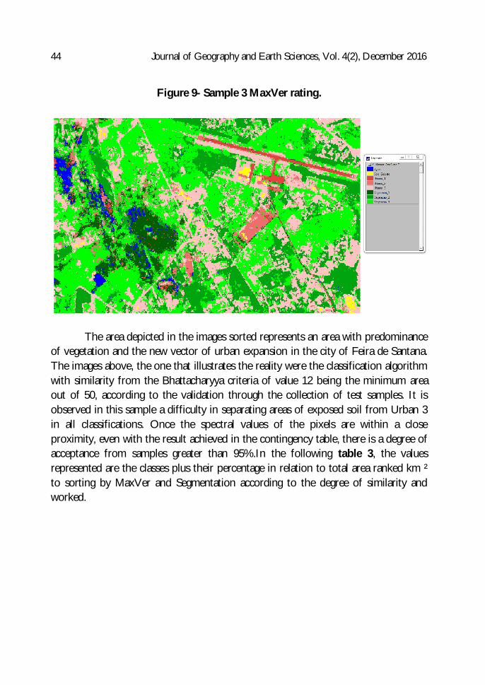
Figure 9- Sample 3 MaxVer rating.
The area depicted in the images sorted represents an area with predominance
of vegetation and the new vector of urban expansion in the city of Feira de Santana. The images above, the one that illustrates the reality were the classification algorithm with similarity from the Bhattacharyya criteria of value 12 being the minimum area out of 50, according to the validation through the collection of test samples. It is observed in this sample a difficulty in separating areas of exposed soil from Urban 3 in all classifications. Once the spectral values of the pixels are within a close proximity, even with the result achieved in the contingency table, there is a degree of acceptance from samples greater than 95%.In the following table 3, the values represented are the classes plus their percentage in relation to total area ranked km ² to sorting by MaxVer and Segmentation according to the degree of similarity and worked.

Aguilar & Santos 45
Table 3: measure of classes. a) classification by similarity of segmentation 8 and 12; b) targeting 8 similarity rating and 20 area; c) classification by similarity of segmentation 12 and 20; d) rating by Yes 12 similarity segmentation and 50 area; e) MaxVer rating.
(a) (b)
(c) (d)
(e)
For the tables above, the values of the classes Urban 3, Vegetation 3 and exposed soil differed over 10% between the MaxVer results and the results of the segmentation. During the classification phase there were difficulties to separate classes Urban 3 and Exposed Soil and classify them as these presented pixel values very close.
Classes de uso do solo Área (kmxkm) (%)Agua 0,011775 0%Vegetacao_1 0,117025 2%Vegetacao_2 0,858500 17%Vegetacao_3 1,150225 23%Urbano_1 0,133375 3%Urbano_2 0,048650 1%Urbano_3 0,207475 4%Solo_exposto 2,475650 49%Similaridade 8 - Área 12 5,002675 100%
Classes de uso do solo Área (kmxkm) (%)Agua 0,099025 2%Vegetacao_1 0,167925 3%Vegetacao_2 0,469050 9%Vegetacao_3 2,720675 54%Urbano_1 0,125400 3%Urbano_2 0,059125 1%Urbano_3 0,193250 4%Solo_exposto 1,158975 23%Similaridade 8 - Área 20 4,993425 100%
Classes de uso do solo Área (kmxkm) (%)Agua 0,09155 1%Vegetacao_1 0,27358 4%Vegetacao_2 1,27060 17%Vegetacao_3 1,42358 19%Urbano_1 0,11285 2%Urbano_2 0,07493 1%Urbano_3 2,62925 36%Solo_exposto 1,49273 20%Similaridade 12 - Área 20 7,36905 100%
Classes de uso do solo Área (kmxkm) (%)Agua 0,05755 1%Vegetacao_1 1,19600 24%Vegetacao_2 0,86655 17%Vegetacao_3 0,84763 17%Urbano_1 0,07358 1%Urbano_2 0,05540 1%Urbano_3 0,17555 4%Solo_exposto 1,72680 35%Similaridade 12 - Área 50 4,99905 100%
Classes de uso do solo Área (kmxkm) (%)Agua 0,09855 2%Vegetacao_1 0,31313 6%Vegetacao_2 1,05488 21%Vegetacao_3 1,93055 39%Urbano_1 0,06710 1%Urbano_2 0,20585 4%Urbano_3 1,25558 25%Solo_exposto 0,02785 1%MaxVer 4,953475 100%

46 Journal of Geography and Earth Sciences, Vol. 4(2), December 2016
In the classifications by segmentation there was a predominance of areas classified as Exposed Soil, whereas in the classification by MaxVer this has not occurred. Both classifications have a predominance of all vegetation. The classification table by the Bhattacharyya segmentation algorithm with similarity of 12 and 50 was aceepted once the best reality of the area represented the results with the test samples.
The results for targeting with the classification by the Bhattacharyya algorithm
(Figure 10) sample 4, corresponded to the region of the center of the city of Feira de Santana and the result for the maximum likelihood classification (Figure 11) are represented below.
Figure 10 – Threading with rating algorithm sample 04 Bhattacharyya. a) classification by similarity of segmentation 8 and 12; b) targeting 8 similarity rating and 20 area; c) classification by similarity of segmentation 12 and 20; d) classification by similarity of segmentation 12 and 50 area; e) Legend class.
(a) (b)
(c) (d)
(e)

Aguilar & Santos 47
Figure 11- Sample 04 MaxVer rating.
The images classified above portray well the reality of the center of Feira de
Santana as a dense region composed of buildings with high concentration of impervious areas, as shown here represented by the urban classes 1 and 2. The classification MaxVer presented values of a larger soil area as listed above which, however, doesn't portray the reality of the study area. There was similarity between the pixels as classified in classes Urban 2 and Exposed Soil in the MaxVer classification.
The classification by segmentation presented better results for similarity
parameters of 12 for an area of 50. This was more accurate to illustrate the sample as this since it is presented in the field and obtained the best results compared with the test sample. The table 04 values for the classes represents for classification by MaxVer and by segmentation according to the degree of similarity and area tabulated and the percentage of each class according to the total number of pixels classified in the sample.

48 Journal of Geography and Earth Sciences, Vol. 4(2), December 2016
Table 4: measure of classes. a) classification by similarity of segmentation 8 and 12; b) targeting 8 similarity rating and 20 area; c) classification by similarity of segmentation 12 and 20; d) classification by similarity of
segmentation 12 and 50 area; e) MaxVer rating.
(a) (b)
(c) (d)
(e)
The differences displayed in Table 4, refer to the values from classes Urban 1,
Urban 2 and Exposed Soil. In the MaxVer classification, it was portrayed that a larger area of Exposed Soil, on which the spectral values of their pixels are close to the values of the pixels that represent the class Urban 2, caused different results observed in regions classified field. For the Bhattacharyya segmentation algorithm classification, this major urban area was portrayed by classes Urban 1 and Urban 2, according to the local reality.
Classes de uso do solo Área (kmxkm) (%)Agua 0,000000 0%Vegetacao_1 0,000000 0%Vegetacao_2 0,207575 5%Vegetacao_3 0,000000 0%Urbano_1 2,782300 67%Urbano_2 1,146475 28%Urbano_3 0,000000 0%Solo_exposto 0,002450 0%Similaridade 8 - Área 12 4,1388 100%
Classes de uso do solo Área (kmxkm) (%)Agua 0,00000 0%Vegetacao_1 0,00000 0%Vegetacao_2 0,29283 7%Vegetacao_3 0,00000 0%Urbano_1 2,36218 56%Urbano_2 1,51755 36%Urbano_3 0,00000 0%Solo_exposto 0,01370 0%Similaridade 8 - Área 20 4,18625 100%
Classes de uso do solo Área (kmxkm) (%)Agua 0,000000 0%Vegetacao_1 0,000000 0%Vegetacao_2 0,378850 9%Vegetacao_3 0,000000 0%Urbano_1 1,551375 37%Urbano_2 2,219525 53%Urbano_3 0,000000 0%Solo_exposto 0,025750 1%Similaridade 12 - Área 20 4,1755 100%
Classes de uso do solo Área (kmxkm) (%)Agua 0,00000 0%Vegetacao_1 0,00000 0%Vegetacao_2 0,33603 8%Vegetacao_3 0,00000 0%Urbano_1 1,22953 29%Urbano_2 2,58305 62%Urbano_3 0,00000 0%Solo_exposto 0,03900 1%Similaridade 12 - Área 50 4,1876 100%
Classes de uso do solo Área (kmxkm) (%)Agua 0,000000 0%Vegetacao_1 0,000000 0%Vegetacao_2 0,543500 14%Vegetacao_3 0,000000 0%Urbano_1 0,417825 11%Urbano_2 1,780325 47%Urbano_3 0,000000 0%Solo_exposto 1,042625 28%MaxVer 3,784275 100%
Aguilar & Santos 49
Table 4.d presents the results of the Bhattacharyya segmentation classification for grade algorithm similarity of 12 and 50 was adopted since it best represented the reality of the region in accordance with the test sample.
3. Conclusion
Comparatively analyzing the classification, it’s perceived that the classification
by regions based on segmentation was portrayed the reality of samples analyzed better, with both degrees of similarity as the formation of the minimum areas of the regions did not generate good separability between classes since these values were too small.
Samples of the areas to be studied in more detail (Samples 1, 2, 3 and 04) were
chosen according to the representation of areas with different degrees of permeability to verify the response of the classifiers the degree of separability from the classes of use and occupation.
It’s perceived by the classified images that there is a breakthrough of civil
construction driven by urban growth in green areas and margins of water bodies (Salgada Pond), causing negative impacts on the environment and proofing larger areas, even if only for the removal of vegetation (exposed soil). Of the algorithms used, it was realized that the segmentation with similarity of a minimum area of 12 of 20 pixel region presented the best results when it is ranked with the Bhattacharyya algorithms, enabling the separability of classes for use in all the different conditions, with the exception of the sample 4, when the best results were expressed by targeting a similarity of 12 as the minimum training area of the 50 pixels region.
The MaxVer classifier was lower on its results in all 4 samples, and, in
particular, mistaking the class "Exposed Soil" with "Urban 2" and "Urban 3". This result was partially expected due to high spatial resolution of the image (5 m) where a statistical classifier, such as the MaxVer, begins to fail in the separation of classes due to great detailing and variability of scenes. The segmentation, although it is also a technique, at its base, statistical, presents a mixed character, related to object-oriented classification, which allows better differentiation of the classes in high spatial resolution images.

50 Journal of Geography and Earth Sciences, Vol. 4(2), December 2016
In this way, from the results obtained in this work, we can emphasize that remote sensing techniques are presented as a viable solution for the determination of levels and degrees of waterproofing in the urban space, what validates as an efficient tool to urban planning.
References
CRUZ, Zargo Quaresma da; RIBEIRO, Gilberto Pessanha. Ensaios de segmentação e
classificação digital de imagens CBERS utilizando o Sistema SPRING em uma unidade de conservação ambiental. Estudo de Caso: Parque Nacional da Serra dos Órgãos (PARNASO). II Simpósio Brasileiro de Ciências Geodésicas e Tecnologias da Geonformação. Recife, setembro de 2008.
SANTOS, Lilliam Rosa Prado dos. O processo de urbanização e impermeabilização do solo em Curitiba : causas , consequências e propostas para minimizar os impactos ambientais. URBEL, Belo Horizonte , 2008.
OLIVEIRA, Ivani Matos de; ZEILHOFER, Peter; SANTOS, Emerson Soares dos. Segmentação para classificação de áreas urbanas a partir de imagem digital do Landsat7/ETM+: Estudo de caso – Cuiabá-MT. Anais do XII SBSR, INPE, Florianópolis, abril de 2007, páginas 6011-6018.
PEREIRA, Marcus Felipe Mourão; RIBEIRO, Gilberto Pessanha. Mapeamento Digital de Zona Urbana em Teresópolis (RJ), adjacente ao Parque Nacional da Serra dos Órgãos (PARNASO), a partir de imagens IKONOS II. II Simpósio Brasileiro de Ciências Geodésicas e Tecnologias da Geoinformação. Recife, setembro de 2008.
SOUTO, Roberto Pinto. Segmentação de imagem multiespectral utilizando-se o atributo Matiz. Dissertação de Mestrado. R. P. Souto. – São José dos Campos: INPE, 2000. 171p.
TUCCI, C.E.M. Hidrologia: ciência e aplicação. 2ª Ed., Porto Alegre. Rio Grande do Sul (RS). Editora Universidade. 2000.
VENDRAME, Iria Fernandes; LOPES, Wallace Alan Blois. Análise do crescimento urbano e seus efeitos na mudança da dinâmica de escoamento superficial da bacia do Pararangaba. Anais do XII Simpósio Brasileiro de Sensoriamento Remoto. Goiânia, abril de 2005. INPE, p.2555-2562.
YILDIZ, Selin; DOKER, Mehmet. Fatih. Monitoring urban growth by using segmentation-classification of multispectral Landsat images in Izmit, Turkey. Springer International Publishing Switzerland 2016, 6 June 2016.