the house of john blair of adamton - wordpress.commain range, while the laigh house may be the north...
TRANSCRIPT

I I
Ayrshire Collections Volume Eleven Number Six
The House of John Blair of Adamton A Medieval town-house in
Ayr
James Hunter
AYRSH IRE ARCHAEOLOGICAL AND NATURAL HISTORY SOC IETY
1976

. JC ·:- ·.,,:-;,,,... .
This account is based on a survey done during JanuaryMarch 1972, while the property commonly known as · Gadgirth House' situated at 68/70 High Street was beingdemolished. This marked the disappearance of the lastrecognisably medieval house in Ayr apart from Loudoun Hall- a loss which was unfortunate, but all too typical of theWest of Scotland. It should be made clear that the responsibility for this does not lie with Marks and Spencers whosebuilding now occupies the site, and that they and theirarchitects, Munro and Partners of Glasgow, co-operated mostfully in allowing this survey to be carried out. Thanks are dueto them, to the helpful demolition workmen on the site, andto the large number of voluntary helpers whose work producedthe information presented here. Work was unusuallystrenuous and dirty even by the standards of rescuearchaeology - involving stripping plaster from walls andcutting through modern brickwork and concrete. Those whospent long heartbreaking hours at this, or at the equallyimportant work of meas,urement. drawing, photography, andhistorical research had the satisfaction of seeing that in theend we were able to unravel more information about thisbuilding than at first seemed possible.
It was originally intended to undertake excavation in the hope of tracing the development of the site back to the early Middle Ages, but it was found that modern alterations had so destroyed earlier levels as to make this fruitless. Work was therefore limited to architectural rather than archaeological problems. Historical research was largely restricted to published sources and relatively recent legal documents. The results obtained indicate that a more extensive investigation of historical sources would almost certainly provide further information, and that if this were extended to the rest of the old town centre it could create a valuable framework for research into the archaeology of medieval Ayr, about which practically nothing is known. The gradual re-development of the town centre means that archaeological evidence has been steadily destroyed during recent years, and that much of the early history of Ayr has already been lost. The account which follows is offered as a small and regrettably incomplete contribution towards the establishment of at least some firm archaeological knowledge about medieval Ayr.
Opposite: Mcl<ill's Close. Engraving by Robert Bryden (1887)
111

THE SITE The map (fig. 1 ) , adapted from the Ordnance Survey of
1856 shows the general location of the house — lying close to two ancient streets — High Street and Bridge Street. Note that it did not face the High Street directly, but was entered from a small courtyard behind the buildings lining the street. This can be explained if the properties facing High Street had been erected first, in the normal Scottish system, while those behind were ' back tenements ' crushed in at a later date when building space was short. The striplike configuration of building along the High Street shown on the map is typical of the ' rigs ' of medieval Scottish towns — long narrow feus running back from the street. The arrangement of buildings seen in the 19th Century, and to a lesser extent still surviving today, thus seems to be a fossilised replica of the early medieval land distribution in Ayr, the early arrangement being overlaid with buildings in later periods.
On this interpretation, Blair's House would be a later addition to a pre-existing plan, and quite divorced from the buildings between it and the street. It had sometimes been suggested (e.g. by Bryden^) that the building shown on the map as the Queens Head Inn formed part of the same house. We found no indication of this. The Mid-Nineteenth Century painting of the Fish Cross by D. 0 . HiiP shows the entrance to Gadgirth Vennel from the High Street. The buildings shown facing the street are clearly Medieval, and seem quite large enough to represent two substantial houses in their own right, one having a tower attached. These High Street buildings, including the lower parts of the tower, still partly survived at the time of our survey — unfortunately it would have been too big an undertaking to extend our work to include them also. Therefore the extent to which the buildings surviving in 1972 were medieval was not investigated, and their ownership in the Middle Ages is not certain. However, it does seem clear that these buildings are a separate problem.
HISTORY Bryden explains the origin of ' Gadgirth House ' thus:— ' It was built originally by John Blair of Adamton, some
time before 1470, and subsequently became the residence of the Chalmers of Gadgirth. In 1654 it was sold by John
1. Bryden — 'Etchings of Auld Ayr ' see section headed ' McKiU's Close."
2. See A. Dunlop — 'The Royal Burgh of Ayr ' p. 192.
112
\ \
„UILDINGS ON M E D I E V A L R I G S
A Y R TOWN C E N T R E c.1850 Figure 1
113

Chalmer of Gai tg i r th t o T h o m a s Blare, an A y r merchan t , and m e m b e r of the A d a m t o n fami l y . '
Bryden does no t c i te his source , bu t the in fo rmat ion m i g h t have c o m e f r o m char ters w h i c h it has no t n o w been possible t o t race.
The ex is tence of such a house c o n f o r m s to the normal pa t te rn of local landed fami l ies ma in ta in ing houses in the t o w n as w e l l as on the i r estates — and numerous references s h o w tha t bo th the Blairs and the Cha lmers o w n e d and used houses in A y r .
The Blairs of A d a m t o n , in M o n k t o n par ish, w e r e a cadet of Blair of t ha t I lk, o r ig ina t ing abou t 1390, and had c lose connec t i ons w i t h the burghs of A y r and Prestwick^. It seems l ikely tha t Bryden deduced the or ig in of the House f r o m an en t ry in the Ob i t Book of the Church of St . John"*.
' T h e Obi t of T h o m a s C h a p m a n , Burgess of A y r . . . w h i c h T h o m a s died . . . in 1470 . . . six shi l l ings and e igh tpence annual ly t o be levied f r o m his T e m p l a r t e n e m e n t , ly ing on the east par t of the vennel leading f r o m the M a r k e t Cross to the W a t e r of A y r , and on the no r th par t of the new tenement of John Blair of Adamton . . .'
This canno t be taken in i tself as c o m p l e t e l y conc lus ive ev idence tha t the House w a s bu i l t before 1470. ' T e n e m e n t ' no rma l l y impl ies the w h o l e feu rather than the bu i ld ing speci f ica l ly . However , the use of the descr ip t ion ' n e w ' does sugges t t ha t ' t e n e m e n t ' has the sense of ' house ' in th is case.
The locat ion of the site is descr ibed more fu l l y in a later Obi t .5
' T h e Ob i t o f A r t h u r H u n t a r . . . f r o m his t e n e m e n t in the smal l vennel leading f r o m the Cross of A y r t o the w a t e r , b y and oppos i te to the large tenement of John Blair of Adamton, b e t w e e n the t e n e m e n t s o m e t i m e of James B r o w n on the one , and the t e n e m e n t of A lexander Osborne on the o t h e r . . . in the year of ou r Lord 1501 ' . . .
The Blairs s t i l l o w n e d the p roper ty t i l ! shor t l y before 1585, w h e n i t w a s o w n e d by David W a l l a c e , accord ing t o a Sasine recorded in M a s o n ' s Pro toco l Book.^
3. Paterson — ' History of the County of Ayr ' vol. 2, p. 382. 4. Paterson — ' The Obit Book of tlie Church of St. John ' p. 46 5. Op. cit. p. 57. 6. Archaeological Collections of Ayrshire and Galloway Vol. VI p. 196.
114
' Sasine given by . . . David W a l l a c e , Burgess of A y r . . . of the t e n e m e n t of land call Temp le T e n e m e n t , ly ing in the said burgh be tween the tenement sometime of David Blair of Adamton, n o w of David Wa l l ace , on the east , and the venne l leading t o w a r d the W a t e r of A y r f r o m the marke t -c ross of the said burgh on the w e s t . . .'
In fac t , apar t f r o m Bryden 's s ta tement , i t has no t been possible t o f ind any ev idence tha t the Cha lmers ever o w n e d th is p roper ty — if t hey d id so it w a s c lear ly on ly af ter 1585. They were cer ta in ly a long establ ished local f am i l y , o r ig ina t ing as the Camerar ius or Royal Chancel lor , and ho ld ing Gadg i r th estate in Coy l ton Parish f r o m c.1160 if no t earlier.^ They d id o w n p rope r t y in A y r — g iv ing a piece of land to the Domin ican Friars in 1500.^ In 1591 there is a record of a meet ing in the house of Dav id Chalmers.^ Sir J o h n Cha lmers b o u g h t Loudoun Hall in 1657, and reta ined i t fo r a f e w years.^°
However , if the Chalmers o w n e d the house descr ibed here, it can have been fo r on ly a re la t ive ly brief pe r iod . I t seems more l ikely t ha t they o w n e d the t o w e r house on the High St reet , and tha t Bryden is r igh t in ass ign ing th is p rope r t y to t h e m , bu t w r o n g in assuming tha t the back t e n e m e n t w a s par t o f the same house. The venne l w a s k n o w n as Gadgi r th Venne l f r o m at least 1559' ' i — ( w h e n Chalmers cannot have o w n e d Blair 's H o u s e ) , and i t seems ve ry l ikely t ha t s ince Blair 's House s t o o d on th is vennel it p icked up the des ignat ion ' Gadg i r th House. ' T o avo id con fus ion the back t e n e m e n t su rveyed b y us w i l l be t e r m e d BLAIR 'S HOUSE, a l though th is has no t been used as a local name in recent t imes .
The later o w n e r s h i p of the House can be ascer ta ined f r o m ex tan t d o c u m e n t s , and as w i l l be seen f r o m the f o l l o w i n g D ispos i t i on , Bryden is at least cor rec t in say ing tha t the House passed back in to the hands of a branch of the Blair f am i l y — and i t remained w i t h t h e m t i l l the ear ly N ine teenth Cen tu ry , thereaf te r passing t h r o u g h m a n y o w n e r s .
Thus i t changed hands on 30 th M a y , 1846, b y a D ispos i t ion by J a m e s M o r r i s o n , Upho ls te re r in Ed inburgh , in
7. Paterson— Vol. 1 p. 323. 8. Archaeological and Historical Collections of Ayr and Wigton Charters
of the Friars Preachers of Ayr, p. 66. 9. Archaeological Collections, Vol. VI, p. 253. 10. Sir James Fergusson — 'Loudoun Hall.' 11. Pryde — 'Ayr Burgh Accounts' p. 32. ' . . . t h e Larde of Gaitgirthis
Vennel.'
115
favour of Dennis Currie, Pawnbroker in Wal lacetownJ^ At this date Blair's House had begun to fall on bad times, being subdivided into numerous lodgings, and its identity further obscured by the new owner also obtaining possession of two adjacent properties. However, this predates the really extensive modern alterations which made our task of ascertaining the original plan so difficult. In 1846 the buildings corresponded much more closely to the medieval lay-out, and interesting echoes of the medieval house come through the description in the Disposition.
' . . . that back tenement of land which belonged to the deceased James Blair, Writer in Ayr, and afterwards to Agnes Blair, his only child, comprehending the lodging sometime possessed by James Montgomerie, late the Provost of Ayr, the lodging above it sometime possessed by Will iam Ramsay, Surgeon Apothecary in Ayr, with the yard and three cellars thereto belonging the house sometime possessed by William Murdoch, Schoolmaster in Ayr, the chamber sometime possessed by David Smith, Taylor in Ayr, the laigh house sometime possessed by Catherine McWhirter, relict of John Goldie, Flesher in Ayr, with the Brewhouse, Drawhouse, well and middingstead, and also All and Whole that tenement of land consisting of two stories on the west end of the foresaid other tenement, sometime possessed by the said Agnes Blair and her mother, with the two cellars thereto belonging . . .'
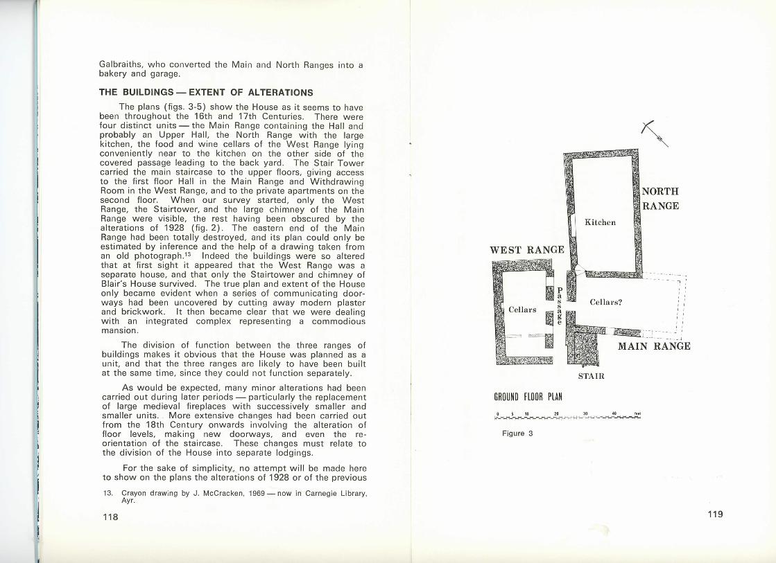
Much of this description can be understood in relation to the plans shown in figure 3. The ' two storeys with two cellars on the west end . . .' can quite confidently be identified with the West Range of Blair's House. The various lodgings with three cellars and a yard must represent the Main Range, while the laigh house may be the North Range. Notice that while the West Range is described along with the rest of the House it is specified as a separate tenement. This must be a relic of early medieval land holding, since, as wil l be explained shortly, the earliest phase of Blair's House definitely included all three ranges, functioning together as parts of the one house. However, this same Disposition later refers to ' the property betwixt the subjects thereby disponed and the High Street,' which is further evidence that, as already argued, the buildings facing the High Street did not belong to the same complex.
After being described and illustrated by Bryden in 1887 (p. 110) the buildings were heavily altered in 1928 by
12. Entered in Particular Register of Sasines for the Royal Burgti of Ayr on 19tli June, 1846.
116 117
Galbraiths, who converted the Main and North Ranges into a bal<ery and garage.
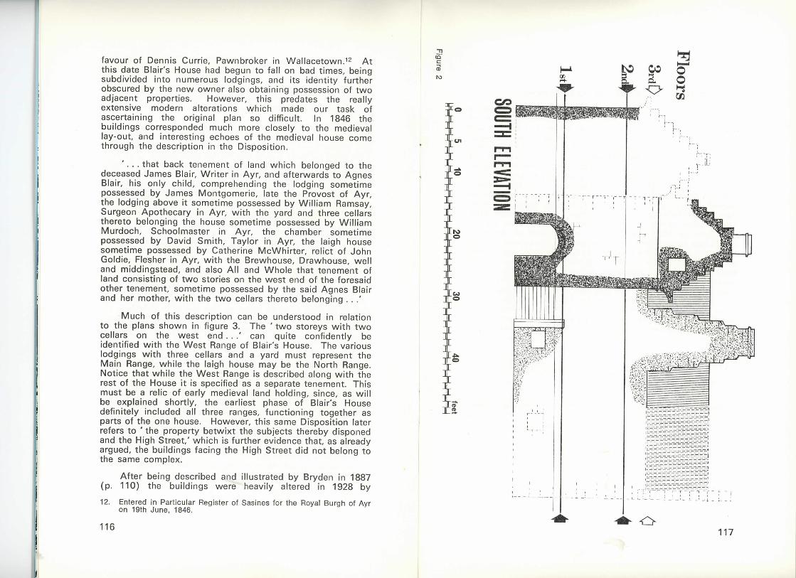
THE BUILDINGS — E X T E N T OF ALTERATIONS The plans (figs. 3-5) show the House as it seems to have
been throughout the 16th and 17th Centuries. There were four distinct units — the Main Range containing the Hall and probably an Upper Hall, the North Range with the large kitchen, the food and wine cellars of the West Range lying conveniently near to the kitchen on the other side of the covered passage leading to the back yard. The Stair Tower carried the main staircase to the upper floors, giving access to the first floor Hall in the Main Range and Withdrawing Room in the West Range, and to the private apartments on the second floor. When our survey started, only the West Range, the Stairtower, and the large chimney of the Main Range were visible, the rest having been obscured by the alterations of 1928 (fig. 2 ) . The eastern end of the Main Range had been totally destroyed, and its plan could only be estimated by inference and the help of a drawing taken from an old photograph.•'^ Indeed the buildings were so altered that at first sight it appeared that the West Range was a separate house, and that only the Stairtower and chimney of Blair's House survived. The true plan and extent of the House only became evident when a series of communicating doorways had been uncovered by cutting away modern plaster and brickwork. It then became clear that we were dealing with an integrated complex representing a commodious mansion.
The division of function between the three ranges of buildings makes it obvious that the House was planned as a unit, and that the three ranges are likely to have been built at the same time, since they could not function separately.
A s would be expected, many minor alterations had been carried out during later periods — particularly the replacement of large medieval fireplaces with successively smaller and smaller units. More extensive changes had been carried out from the 18th Century onwards involving the alteration of floor levels, making new doorways, and even the reorientation of the staircase. These changes must relate to the division of the House into separate lodgings.
For the sake of simplicity, no attempt will be made here to show on the plans the alterations of 1928 or of the previous
13. Crayon drawing by J . McCracken, 1969 — now in Carnegie Library, Ayr.
118 119
Figures 4 and 5
120
two centuries, or to describe these in detail. For the same reason the building is represented by plans and drawings rather than by photographs. The general exterior of the House and the interior details were recorded photographically, but the intrusion of modern alterations makes the character of the original work less easy to see and to appreciate than in drawings.
ARCHITECTURAL STYLE AND DATING
The exterior appearance was part preserved on the south (fig. 2 and p. 110). Here could be seen the arched entrance to the passageway, the crow-stepped Stairtower with its exterior entrance stairway, and the large stepped chimney of the Main Range. The crow-stepped north gable of the West Range was the only other feature visible externally. Crow-stepped gables have had a long history in Scotland, and in themselves are of little dating significance. However, the stepped chimney invites comparison with those on the Place of Paisley. This building too has undergone alteration at various dates, but the main fabric of it seems to be of the one build. There is every reason to think that the main structure of the Place was erected during a period of great building activity at Paisley Abbey in the late 15th and early 16th Centuries. Another detail gives a comparison wi th Loudoun Hall, which certainly dates to much the same period, and this is the chamfer (bevel) used to decorate the surrounds of doorways and windows. All the original doorways and windows in Blair's House were finished in this way — those opening off the passageway being best preserved. The same style can be seen at a number of other early buildings in this area — as at Mearns Castle, Newton Mearns, and the tower of Dean Castle, Kilmarnock. Unfortunately, the chamfer occurs at other periods also, and so its usefulness in dating is restricted. However, another similarity wi th Dean Castle seems to carry greater weight.
The Place at Dean has an interior stair, but this is carried in stairtower which is certainly a later addition. Therefore, when originally built about 1460, during the Boyds' brief period of national power, the Place had an exterior stair at least to first floor level. This is exactly the arrangement found at Blair's House. An exterior stair still exists at Mauchline Tower — which can also be dated to about 1460 due to the presence of a heraldic panel bearing the arms of Abbot Hunter of Melrose. A further similarity between Blair's House and this building in regard to floor structure wil l be described later. Despite the fact that Mauchline Tower is a rather different
121

type of building there seems no reason why those particular comparisons should not be valid.
By way of contrast, large residences built in this area at a later date seem invariably to have internal stairs only. Leaving aside buildings of an essentially defensive nature, which present different problems, one can cite internal stairs at Auchans House, Dundonald, built in the 16th Century and extended in 1644, at the extensive range added to Newark Castle, Port Glasgow in the 1590's, at MacLellan's House built in Kirkcudbright in 1582, and indeed at Loudoun Hall. Interior stairs are also found in such semi-defensive towers as Monkcastle, Kilwinning (c . 1570) and Baltersan, Kirkoswald (c . 1580). The exterior stair continued to be a feature of Scottish architecture till the 19th Century, but after the onset of the 16th Century its use seems to be restricted to humble dwellings except in a few special cases.
While no single irrefutable fact exists to give an exact date for Blair's House, the weight of evidence, both historical and architectural, shows that it ought to belong to the late 15th Century.
Recent work, mainly in the East of Scotland, which is as yet largely unpublished, seems to suggest an upsurge of building activity in 15th Century Scottish towns, often involving the replacement of early medieval timber buildings with buildings in stone — though often still with timber facades or galleries. Timber galleries have been reconstructed at Loudoun Hail, and may be seen on a larger scale on ' J o h n Knox's House ' in the Royal Mile — a building which again has an exterior stair. While there was nothing to suggest that Blair's House had such galleries, it does seem clear that the massive and elaborate timber structure of the floors (see fig. 6) derives from a time when timber framing was an integral part of building technique.
DETAILED DESCRIPTION WEST RANGE — T H E C E L L A R S
This was the best preserved part of the House, although the roof and chimney-heads were modern and the crow-steps of the south gable had been destroyed by the erection of the adjoining 18th Century building. Windows, doorways and other details were not well preserved on the upper floors, but almost all the original features of the cellars were intact. These cellars were entered by two doorways leading off the passage below the stair tower (see fig. 3 ) . These doorways
122
had boldly chamfered jambs on the exterior, and were spanned by arches splayed towards the interior. Both end walls had been given modern reinforcement, but there was no indication that there had been a fireplace in either of them. Thus the cellars had always been intended for storage, and offered no kitchen accommodation. The west side wall seemed quite unaltered, a plain aumbry with no door-check was its only feature. The lower three feet or so of this wall was constructed of sandstone rubble very securely bonded in a gritty lime mortar. Above this level the wall was earth-mortared with only a shallow pointing of lime. This rather slip-shod building method was also noted in the house in Maybole Kirkwynd.^" The east side wall had been mutilated by the insertion of a modern fireplace and chimney at the north end, but the remains of a window survived. The two rybats of the remaining jamb were plain on the interior, but chamfered like the doorways on the exterior.
Between the two doorways another window lit the larger cellar, but was undecorated on the outside, and so might not be the same date as the doorways and the other window. On the inside this window had one jamb splayed, and the other right-angled and aligned with the partition wall which divided the cellars. This wall was built predominantly of hand-made bricks, the regularity of the courses being interrupted in many places by the use of irregular pieces of stone rubble. The wal l was two bricks thick, but had a core two to three inches thick of mortar and rubble. This meant that the length of a brick was not enough to span the thickness of the wal l , and so header courses could not be used. The doorway through this wall connecting the cellars had a wooden lintel, and each jamb was re-inforced with three wooden beams used as through-bonds (fig. 10 ) : The wall reached the underside of one of the massive beams supporting the floor above, and was based on a shallow foundation of stone rubble.
A number of problems are presented by all this. The two cellar doorways were identical, and obviously original — indicating that the cellar was always divided into two. On the other hand one would not normally expect to find a brick wall in a house in Scotland in the 15th Century, or indeed for almost three centuries thereafter, and yet this wall had every appearance of being original. Its position is confirmed by the asymmetical plan of the window, and even if the window might not be original, the position of the partition wall is
14. A house at No. 3 Kirkwynd, Maybole. Surveyed in May 1971. Found to be the townhouse of the Kennedies of Knockdon. Report not yet published.
123

confirmed by the location of the ceiling beam above — which makes this the logical place to put such a division. There might, of course, have been an earlier wall or wooden partition. To check this, the whole wail was carefully taken down. A wooden partition would certainly have left traces of attachment to the beam above — none were found. Nor was there any indication in the wail itself that it had been rebuilt.
Although the use of brick for building in Scotland did not start on any great scale until the late 18th Century, occasional uses at earlier dates can be proved. The ice house built at Castle Huntly in 1670-90 used brick imported from England,^5 and an early half-timbered house in Leith had the panels infilled with b r i c k . C l e a r l y , though, brick was an exotic material in Scotland — and the very structure of the brick wall in Blair's House bears this out. The peculiar width chosen and the addition of awkward pieces of rubble shows that the builder was not familiar wi th the use of bricks, and that there were not quite enough to finish the job. An odd lot of bricks arriving at the harbour as ballast on a ship from England, France or the Netherlands could have been used in just this way. In view of the various pieces of evidence that the wall is original, and the complete absence of evidence that it is not, some such explanation as that given above seems not unlikely.
The earth floor of the cellars corresponded to the bottom of the doorways. Trial trenches revealed subsoil almost immediately below this.
WEST RANGE — F I R S T FLOOR
This room, or perhaps two rooms, had originally been entered by a door at the north end leading directly from the Hall, and a doorway at the south end, facing the main entrance (fig. 4 ) . These doorways were chamfered like those leading to the cellars on the floor below. The north wall had a fireplace finely carved in grey sandstone in late 17th Century style, wi th a bolection moulding (fig. 8 ) . A t this date, and probably earlier, this room is likely to have acted as a Withdrawing Room — adjacent to the Hall and on the same level. Alterations of the 18th or early 19th Century could be seen at the south end. A fireplace with plain, sharp-edged jambs shared alternate rybats with a doorway leading
15. Proceedings of the Society of Antiquaries of Scotland. Vol. XCIII p. 246. E. Urquliart.
16. J. Small — 'Scottish Architectural Details' plate XU.
124
through the south gable to the adjoining building (the fact that one tenant had occupied a part of each building is in fact mentioned in the disposition quoted earlier). A doorway at the south end of the east wall was in similar style, and was interesting in that it was incompatible wi th the staircase on the other side of the wall , which did however correspond quite well wi th the position of the original doorways. Clearly the stair had been completely re-aligned during the subdivision of the property, and then restored to more or less its original position.
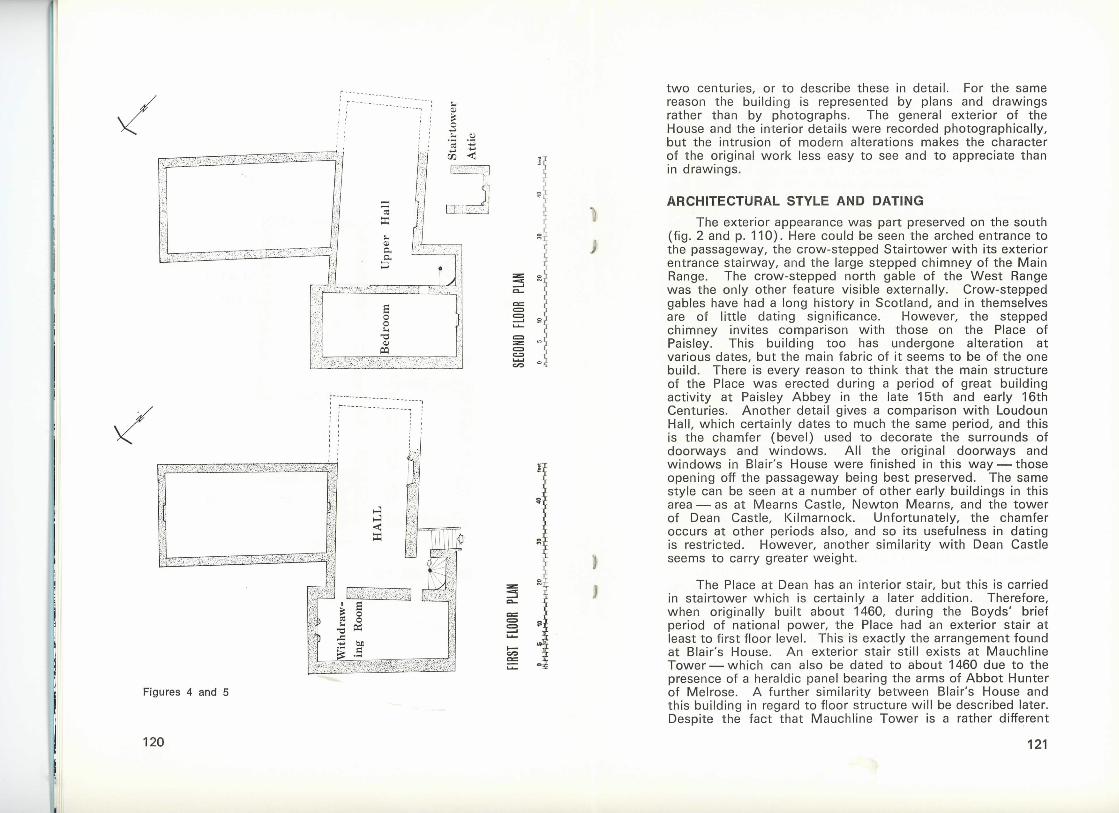
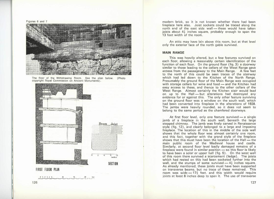
The main feature of interest at this level was the floor — part of the original flooring having been sealed in and preserved by the insertion of a modern concrete floor some four feet above the original level. This was the only original floor to survive. Its weight was carried on four massive beams, twelve inches square, run into the side walls and lying seven feet apart (figs. 6 and 7 ) . These seven foot gaps had been spanned by four inch square secondary joists, wi th their ends let into notches cut in the top faces of the beams so that tops of the joists lay flush wi th the tops of the beams. Only four joists survived, but the notches showed the position of the rest. Floorboards survived only at the north end. These were six to eight inches broad and about one inch thick, and were tongued and grooved. Since the boards lay across the joists they ran parallel to the beams below. This method of flooring seems to have been quite common. In the Main Range, and also in the house in Kirkwynd, Maybole, stumps of slender beams were found in end walls, indicating the existence of supporting transverse beams. The beams did not survive in either case, so it is not known whether the joists were notched into them or simply laid on top. In Mauchline Tower the floor of the hall was carried on three beams — two laid along the side walls on projecting corbels, and one in the middle of the room, which still survives. This has no notches — so in this case the joists were laid on top. The beam is supported by a massive central post, and there are clear traces of wooden partitions which once divided the ground floor.
WEST RANGE —UPPER FLOORS The second floor was heavily altered (fig. 5 ) . The south
gable had a fireplace of 18th Century character — the jambs and lintel each made of a single stone, and decorated wi th a narrow bead moulding. However, this was set within a cavity left by the removal of a larger earlier fireplace. The interior face of the north gable had been completely rebuilt in
125
126
modern brick, so it is not known whether there had been fireplace here also. Joist sockets could be traced along the north end of the east side wall — these would have taken joists about 4^ inches square, probably enough to span the 13 foot width of the room.
An attic may have lain above this room, but at that level only the exterior face of the north gable survived.
MAIN RANGE This was heavily altered, but a few features survived on
each floor, allowing a reasonably certain identification of the function of each floor. On the ground floor (fig. 3 ) a doorway similar to those leading to the cellars of the West Range gave access from the passageway to the Main Range. A few feet to the north of this could be seen traces of the stairway which had led down to the Kitchen of the North Range. Presumably the ground floor of the Main Range was occupied with storage cellars for wine and food — and the Kitchen had easy access to these, and thence to the other cellars of the West Range. Almost certainly the Kitchen stair would lead on up to the Hall — but alterations had destroyed any evidence for or against this. The only other feature surviving on the ground floor was a window on the south wal l , which had been converted into fireplace in the alterations of 1928. The jambs were heavily rounded, so it does not seem to belong to the same period as the chamfered doorways.
At first floor level, only one feature survived — a single jamb of a fireplace in the south wal l , beneath the large stepped chimney. The jamb was finely carved in Renaissance style (fig. 12 ) , and clearly belonged to a large and imposing fireplace. The location of this in the middle of the side wal l shows that the whole floor was almost certainly one room, and this fact, together with the grand style of the fireplace shows that this must have been the location of the Hall — the main public room of the Medieval house and castle. Similarly, at second floor level badly damaged remains of a fireplace were found in similar position — so this floor is likely to have been a solar or upper hall (fig. 5 ) . On the west wall of this room there survived a scarcement ( ledge). The joists which had rested on this had been socketed further into the wal l , and the stumps of some survived — 4 i inches square. As already mentioned, these joists must have been supported on transverse beams, but no trace of these remained. This room was wide — 1 7 ^ feet, and this width would require joists at least 8 inches deep to span it. The use of transverse
127

beams with slender longitudinal joists carrying the floorboards would cut down on the number of heavy timbers required.
A t the west end a fireplace and doorway had been made in the 18th or early 19th Century. These had heavily rounded jambs and shared rybats. A new floor had been put in at this period, some two feet below the original level — and leaving the traces of the earlier floor already described.
NORTH RANGE
Since the natural ground level sloped towards the river, this range lay at a slightly lower level — hence the stair leading down to the ground floor Kitchen. The original floor of this had been dug out to depth of over a foot in recent times. A scarcement along the wall, corresponding to the case of the fireplace, marked the original level. The fireplace (fig. 10) was partly obscured by a modern concrete floor, and it was not possible to expose it entirely. A low relieving arch surmounted a lintel formed of three blocks roughly wedged together spanning a gap of ten feet. The lintel seems to have given problems due to its crude construction. A t some date the left hand jamb had been renewed, and apparently at the same time another jamb had been inserted reducing the size of the fireplace by about one third, and leaving a cupboard at the side. The original jamb survived on the right — splayed and wi th the corner either rounded or chamfered — it was difficult to tell due to the rough and worn surface of the stonework.
A t the south-west corner of the room was the remains of a stair; stumps of treads projected from a rounded recess in the west wall . As already explained this stair led up to the cellars of the Main and West Ranges, and probably originally also gave access to the Hall.
The east side wall of the North Range was intact in the Kitchen, at first floor level it had been removed and replaced with brick pillars. The level of the first floor was marked by a scarcement on the west wall above the top of the fireplace. Fireplaces in the north and south walls were of 18th Century type, no traces of any earlier features remained. A t second floor level some stretches of the east wall were incorporated in modern brickwork. The west wall had splayed windows which might have been early, although the surrounds had been renewed. Fragments of fireplaces could be seen in the north and south gables, the raggle for the roof of this attic could be seen on the north gable.
129


STAIR TOWER This occupied the south-east angle between the Main
and West Ranges, the south gable of the Tower being almost flush with that of the West Range. The south wall of the Tower was carried over the passage by an arch, the rest of the passage being roofed with modern concrete. It was at first thought that the whole passage had originally been stone vaulted, but the stump of a wooden beam was discovered in the passage wall laid end-to-end with one of the beams of the West Range (fig. 6 ) . It seems therefore that the passage ceiling was carried on wooden beams, and that no stone vaults existed in this house.
The exterior stair built on the east side of the Tower gave access to the main entrance on the first floor. The surround of the doorway had been completely renewed, but an extremely weathered heraldic panel was still in place above it.
As already explained, the stair itself had undergone two major alterations. Wooden docks in the stone treads showed that these had once been clad with boards — explaining the lack of wear on the steps.
A t the top of the Tower, above the level of the rest of the house, was a small attic room, with a corbelled fireplace (fig. 8 ) . A similar but larger example was found in the Kirkwynd, Maybole, and since there is another rather ruined example in the Refectory at Crossraguel Abbey, this type must have originated in the 15th or early 16th Century.
CONCLUSIONS The results of this investigation suggest that the house
was indeed built by John Blair of Adamton shortly before 1470, that it remained in the possession of this family for about a century, and that substantial portions of the original house survived in 1972 despite numerous alterations. Whether this property was ever owned by the Chalmers of Gadgirth must at the moment remain an open question — but it is certain that the name Gadgirth Vennel derives from their ownership of a different house — and the Tower House on High Street is the most likely candidate.
Blair's House must have been larger and grander than most in Medieval Ayr, but many of its features must have been found in smaller houses also. It is to be hoped that historical research can disentangle the facts about the ownership of property and that remains of a wider variety of dwellings can be uncovered by archaeological methods while it is still possible to do so.
132