the history and areal distribution of exploration drilling...
TRANSCRIPT

1
The History and Areal Distribution of Exploration Drilling Targets Categorized by Play Type, North Slope and Offshore Arctic Alaska
Alaska Geological Society, Anchorage, Alaska
Presentation by Laura Gregersen, Petroleum Geologist Co-author: Garrett Brown, GeologistAlaska Department of Natural Resources, Division of Oil and GasMay 29, 2019

0
5
10
15
20
25
30
35
1944 1948 1952 1956 1960 1964 1968 1972 1976 1980 1984 1988 1992 1996 2000 2004 2008 2012 2016
NSNPRA
Foothills ANWR
OCS OCS
+
Nu
mb
er
of
Ex
plo
rati
on
We
lls
Dri
lle
d
Completion Date (Year)
NORTH ALASKA EXPLORATION WELLS- IDENTIFIED BY SALE REGIONS -
Data source: AOGCC; AKDOG Public Decisions; BLM
US Navy US Navy & USGS USGS

0
500
1000
1500
2000
0
5
10
15
20
25
30
35
1944 1948 1952 1956 1960 1964 1968 1972 1976 1980 1984 1988 1992 1996 2000 2004 2008 2012 2016
NSNPRA
Foothills ANWR
OCS OCS
+
Nu
mb
er
of
Ex
plo
rati
on
We
lls
Dri
lle
d
Completion Date (Year)
NORTH ALASKA EXPLORATION AS INFLUENCED BY- LAND AVAILABILITY, PIPELINE ACCESS, AND KEY DISCOVERIES -
Oil
+ N
GL
Pro
du
ctio
n (
M B
BL
/D
ay
)
US Navy US Navy & USGS USGS
Land STOP
Oil
Data source: AOGCC; AKDOG Public Decisions; BLM

WHAT PLAYS ARE THE EXPLORERS TARGETING?- GENERALIZED STRATIGRAPHIC COLUMN AND CROSS SECTION -
Figure modified from Houseknecht and Bird, 2006; Garrity and others, 2005; and AKDOG.
0’
5,000’
10,000’
15,000’
20,000’
25,000’
30,000’
SL
1
2 3
4
56
7
8
9
Kilo
met
ers
Figure modified from Bird and Molenaar, 1992; AKDOG; DGGS; and P. Decker personal communication.
1
12 2
33
4
5
4
5
BEA
UFO
RTI
AN

HOW DO PLAYS CONTRIBUTE TO PRODUCTION?- THROUGHOUT TIME AND TODAY -
0
500
1,000
1,500
2,000
2,500
1969 1973 1977 1981 1985 1989 1993 1997 2001 2005 2009 2013 2017M
BB
LS/D
ay
North Alaska Oil + NGL Production by Play Type
JRSCshoreface
BRKNTurbidite
BRKNTopset
CRCSrift
ELSM
Year
74%2%
20%
1%3%
Percent of Total Production through 2018 (~18 Billion BBLS)
12%
48%28%
2%10%
Percent of Production in 2018 (187 Million BBLS)
Data source: AOGCC; AKDOG
Figure modified from Houseknecht and Bird, 2006; Garrity and others, 2005; and AKDOG.
1
2
3
4
5
BEA
UFO
RTI
AN

EXPLORATION DRILLING TARGETS – ALL CATEGORIES- AND REGIONAL TECTONIC ELEMENTS -
Beaufort SeaChukchi Sea
Arctic Ocean
NPRA
ANWR 1002 Area
Foothills
Anticlinal TrendsKirshner, 1994
Beaufort SeaChukchi Sea
Arctic Ocean
NPRA
ANWR 1002 Area
Foothills

Completion Date (Year)
Nu
mb
er
of
We
lls
Ta
rge
tin
g O
bje
ctiv
eCOUNT OF EXPLORATION TARGETS BY YEAR
- ELLESMERIAN CLASTICS AND CARBONATES -
Oil
+ N
GL
Pro
du
ctio
n (
M B
BL
S/
Day
)
1 1 1 1
25
11
1
4
23
98
11
67
10
8
6
2
89
6
2 1 2 23
13
13
2 1 1 2
43
5
31 1
4
1 -0
3
6
9
12
15
18
21
24
27
1944 1948 1952 1956 1960 1964 1968 1972 1976 1980 1984 1988 1992 1996 2000 2004 2008 2012 2016
1 1 1 1
25
11
1
4
23
98
11
67
10
8
6
2
89
6
2 1 2 23
13
13
2 1 1 2
43
5
31 1
4
10
200
400
600
800
1000
1200
1400
1600
1800
2000
0
3
6
9
12
15
18
21
24
27
1944 1948 1952 1956 1960 1964 1968 1972 1976 1980 1984 1988 1992 1996 2000 2004 2008 2012 2016
1 1 1 1
25
11
1
4
23
98
11
67
10
8
6
2
89
6
2 1 2 23
13
13
2 1 1 2
43
5
31 1
4
1
PBU Ivsk & PBU Lsbr, 1968
MPU Sgrv , 1969
PBU NPB, 1970
Gwyder Bay, 1969
Kavik, 1969
Kemik, 1972
0
200
400
600
800
1000
1200
1400
1600
1800
2000
0
3
6
9
12
15
18
21
24
27
1944 1948 1952 1956 1960 1964 1968 1972 1976 1980 1984 1988 1992 1996 2000 2004 2008 2012 2016
1 1 1 1
25
11
1
4
23
98
11
67
10
8
6
2
89
6
2 1 2 23
13
13
2 1 1 2
43
5
31 1
4
1
PBU Ivsk & PBU Lsbr, 1968
MPU Sgrv , 1969
PBU NPB, 1970
EDCT Kkkk, 1978
EDCT Ivsk, 1982
N Star Ivsk, 1984
Gwyder Bay, 1969
Kavik, 1969
Kemik, 1972 Sandpiper, 1986
0
200
400
600
800
1000
1200
1400
1600
1800
2000
0
3
6
9
12
15
18
21
24
27
1944 1948 1952 1956 1960 1964 1968 1972 1976 1980 1984 1988 1992 1996 2000 2004 2008 2012 2016
1 1 1 1
25
11
1
4
23
98
11
67
10
8
6
2
89
6
2 1 2 23
13
13
2 1 1 2
43
5
31 1
4
1
PBU Ivsk & PBU Lsbr, 1968
MPU Sgrv , 1969
PBU NPB, 1970
EDCT Kkkk, 1978
EDCT Ivsk, 1982
N Star Ivsk, 1984
PBU Ptmc Ivsk, 1997
EDCT Eider, 1998
PBU Raven, 2001
EDCT Sgrv Ivsk, 2009
Gwyder Bay, 1969
Kavik, 1969
Kemik, 1972 Sandpiper, 1986
Liberty, 1997
0
200
400
600
800
1000
1200
1400
1600
1800
2000
0
3
6
9
12
15
18
21
24
27
1944 1948 1952 1956 1960 1964 1968 1972 1976 1980 1984 1988 1992 1996 2000 2004 2008 2012 2016
US Navy US Navy & USGS
Data sources: AOGCC; AKDOG; USGS; BOEM; DOE/NETL
= Discovery (Developed)
= Discovery (Produced > 440 MM BBLS)
= Discovery (Undeveloped)

ELLESMERIAN EXPLORATION TARGETS- CLASTIC AND CARBONATE DEPOSITION ON A STABLE SHELF -
50 100 Miles0
Beaufort SeaChukchi Sea
Arctic Ocean
NPRA
ANWR 1002 Area
Foothills
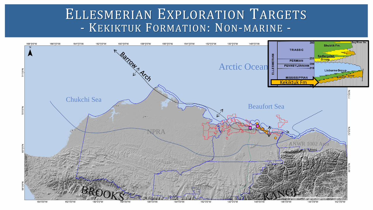
ELLESMERIAN EXPLORATION TARGETS- KEKIKTUK FORMATION: NON-MARINE -
Kekiktuk Fm
100 Miles500
Beaufort SeaChukchi Sea
Arctic Ocean
NPRA
ANWR 1002 Area
Foothills

ELLESMERIAN EXPLORATION TARGETS- LISBURNE GROUP: PLATFORM CARBONATES -
Kekiktuk Fm
Lisburne Gp
100 Miles500
Beaufort SeaChukchi Sea
Arctic Ocean
NPRA
ANWR 1002 Area
Foothills

ELLESMERIAN EXPLORATION TARGETS- SADLEROCHIT GROUP NON-MARINE TO SHALLOW MARINE -
Kekiktuk Fm
Sadlerochit Gp
Lisburne Gp
100 Miles500
Beaufort SeaChukchi Sea
Arctic Ocean
NPRA
ANWR 1002 Area
Foothills

ELLESMERIAN EXPLORATION TARGETS- SHUBLIK AND SAG RIVER FORMATIONS: MARINE -
Shublik Fm
Kekiktuk Fm
Sadlerochit Gp
Lisburne Gp
Sag River Fm
100 Miles500
Beaufort SeaChukchi Sea
Arctic Ocean
NPRA
ANWR 1002 Area
Foothills

EXPLORATION TARGETS AND DISCOVERIES BY YEAR- JURASSIC SHOREFACE -
Nu
mb
er
of
We
lls
Ta
rge
tin
g O
bje
ctiv
e
Completion Date (Year)
1 1 1 1
3
1
2
1 1 1
2
3 3
2
3
2
1 1
3
4
2
4
8
2
3
4
10
6
2
4
1
2
5 5
2
5
4
3
2
-0
2
4
6
8
10
12
1944 1948 1952 1956 1960 1964 1968 1972 1976 1980 1984 1988 1992 1996 2000 2004 2008 2012 2016
Oil
+ N
GL
Pro
du
ctio
n (
M B
BL
S/
Day
)
1 1 1 1
3
1
2
1 1 1
2
3 3
2
3
2
1 1
3
4
2
4
8
2
3
4
10
6
2
4
1
2
5 5
2
5
4
3
2
0
20
40
60
80
100
120
140
0
2
4
6
8
10
12
1944 1948 1952 1956 1960 1964 1968 1972 1976 1980 1984 1988 1992 1996 2000 2004 2008 2012 2016
1 1 1 1
3
1
2
1 1 1
2
3 3
2
3
2
1 1
3
4
2
4
8
2
3
4
10
6
2
4
1
2
5 5
2
5
4
3
2
E Barrow Gas, 1974
S Barrow Gas, 1949
0
20
40
60
80
100
120
140
0
2
4
6
8
10
12
1944 1948 1952 1956 1960 1964 1968 1972 1976 1980 1984 1988 1992 1996 2000 2004 2008 2012 2016
1 1 1 1
3
1
2
1 1 1
2
3 3
2
3
2
1 1
3
4
2
4
8
2
3
4
10
6
2
4
1
2
5 5
2
5
4
3
2
E Barrow Gas, 1974
S Barrow Gas, 1949
CRU Alpine, 1994
CRU Fiord Nechelik , 1992
Oooguruk Nuiqsuit, 1985
Sikulik Gas, 1988
0
20
40
60
80
100
120
140
0
2
4
6
8
10
12
1944 1948 1952 1956 1960 1964 1968 1972 1976 1980 1984 1988 1992 1996 2000 2004 2008 2012 2016
1 1 1 1
3
1
2
1 1 1
2
3 3
2
3
2
1 1
3
4
2
4
8
2
3
4
10
6
2
4
1
2
5 5
2
5
4
3
2
E Barrow Gas, 1974
S Barrow Gas, 1949
CRU Alpine, 1994
CRU Fiord Nechelik , 1992
GMT Alpine, 2002
Oooguruk Nuiqsuit, 1985
Sikulik Gas, 1988
Spark Rendevous, 2000
Pikka JRSC, 2014
0
20
40
60
80
100
120
140
0
2
4
6
8
10
12
1944 1948 1952 1956 1960 1964 1968 1972 1976 1980 1984 1988 1992 1996 2000 2004 2008 2012 2016
US Navy US Navy & USGS
= Discovery (Developed)
= Discovery (Produced > 440 MM BBLS)
= Discovery (Undeveloped)
Data sources: AOGCC; AKDOG; USGS; BOEM; DOE/NETL

ALPINE
NUIQSUITNECHELIK
SIMPSON/KUGRA
BARROW
Beaufort Sea
Chukchi Sea
Arctic Ocean
NPRAANWR 1002 Area
Foothills
JURASSIC SHOREFACE EXPLORATION TARGETS- EARLY RIFTING: OPENING OF ARCTIC OCEAN -

EXPLORATION TARGETS AND DISCOVERIES BY YEAR- CRETACEOUS RIFT -
Nu
mb
er
of
We
lls
Ta
rge
tin
g O
bje
ctiv
e
Completion Date (Year)
1 1 1
8
7
1
3
1
5
3
8
7
4
9
10
7
1
4
5
3
2 2
5
1
4
9
8
3
1
4
2
4 4
2
9
1
3
2
3
2
3
5
1
2
1
6
3
2 2
-0
2
4
6
8
10
12
14
1944 1948 1952 1956 1960 1964 1968 1972 1976 1980 1984 1988 1992 1996 2000 2004 2008 2012 2016
1 1 1
8
7
1
3
1
5
3
8
7
4
9
10
7
1
4
5
3
2 2
5
1
4
9
8
3
1
4
2
4 4
2
9
1
3
2
3
2
3
5
1
2
1
6
3
2 2
0
100
200
300
400
500
600
0
2
4
6
8
10
12
14
1944 1948 1952 1956 1960 1964 1968 1972 1976 1980 1984 1988 1992 1996 2000 2004 2008 2012 2016
Oil
+ N
GL
Pro
du
ctio
n (
M B
BL
S/
Day
)
1 1 1
8
7
1
3
1
5
3
8
7
4
9
10
7
1
4
5
3
2 2
5
1
4
9
8
3
1
4
2
4 4
2
9
1
3
2
3
2
3
5
1
2
1
6
3
2 2
KRU Kprk & MPU Kprk, 1969
PBU Borealis & PBU Aurora, 1969
PBU Put Riv, 1975
PBU West Beach, 1976
Pt Thomson, 1976
Walakpa Gas, 1980
PBU Niakuk, 1985
0
100
200
300
400
500
600
0
2
4
6
8
10
12
14
1944 1948 1952 1956 1960 1964 1968 1972 1976 1980 1984 1988 1992 1996 2000 2004 2008 2012 2016
1 1 1
8
7
1
3
1
5
3
8
7
4
9
10
7
1
4
5
3
2 2
5
1
4
9
8
3
1
4
2
4 4
2
9
1
3
2
3
2
3
5
1
2
1
6
3
2 2
KRU Kprk & MPU Kprk, 1969
PBU Borealis & PBU Aurora, 1969
PBU Put Riv, 1975
PBU West Beach, 1976
Pt Thomson, 1976
Walakpa Gas, 1980
PBU Niakuk, 1985
PBU Pt McIntyre, 1989
CRU Fiord Kprk , 1993
Oooguruk Kprk, 1993
CRU Nanuq Kprk , 1996
PBU Mid Sun, 1997
Burger, 1990
0
100
200
300
400
500
600
0
2
4
6
8
10
12
14
1944 1948 1952 1956 1960 1964 1968 1972 1976 1980 1984 1988 1992 1996 2000 2004 2008 2012 2016
1 1 1
8
7
1
3
1
5
3
8
7
4
9
10
7
1
4
5
3
2 2
5
1
4
9
8
3
1
4
2
4 4
2
9
1
3
2
3
2
3
5
1
2
1
6
3
2 2
KRU Kprk & MPU Kprk, 1969
PBU Borealis & PBU Aurora, 1969
PBU Put Riv, 1975
PBU West Beach, 1976
Pt Thomson, 1976
Walakpa Gas, 1980
PBU Niakuk, 1985
PBU Pt McIntyre, 1989
CRU Fiord Kprk , 1993
Oooguruk Kprk, 1993
CRU Nanuq Kprk , 1996
PBU Mid Sun, 1997
N Star Kprk, 2002
Burger, 1990
Mustang, 2012
Placer, 2004
0
100
200
300
400
500
600
0
2
4
6
8
10
12
14
1944 1948 1952 1956 1960 1964 1968 1972 1976 1980 1984 1988 1992 1996 2000 2004 2008 2012 2016
US Navy US Navy & USGS
= Discovery (Developed)
= Discovery (Produced > 440 MM BBLS)
= Discovery (Undeveloped)
Data sources: AOGCC; AKDOG; USGS; BOEM; DOE/NETL

CRETACEOUS RIFT EXPLORATION TARGETS- CONTINUED RIFTING AND UPLIFT OF BARROW ARCH -
Beaufort Sea
Chukchi SeaArctic Ocean
NPRA
ANWR 1002 Area
Foothills
KUPARUK
??
??
?
??
?
LCU Subcrop Map (Bird, 1998)
Basement
LCU to Ivishak FmIsochore (public well picks)
BURGER
WALAKPA
KEMIK
THOMSON
PUT RIVER
KUPARUK
KUPARUK C

Completion Date (Year)
Nu
mb
er
of
We
lls
Ta
rge
tin
g O
bje
ctiv
eEXPLORATION TARGETS AND DISCOVERIES BY YEAR
- BROOKIAN TURBIDITE -
Oil
+ N
GL
Pro
du
ctio
n (
M B
BL
S/
Day
)
1 1
2
8
1
4
1
4
3
1 1
4
1
4
2 2 2
5
4
3
1
4
1
5
3 3
2
3
4
3 3
5
2 2
4 4
5
1
3 3
1
3 3
1
6
5
3
1
0
2
4
6
8
10
1944 1948 1952 1956 1960 1964 1968 1972 1976 1980 1984 1988 1992 1996 2000 2004 2008 2012 2016
1 1
2
8
1
4
1
4
3
1 1
4
1
4
2 2 2
5
4
3
1
4
1
5
3 3
2
3
4
3 3
5
2 2
4 4
5
1
3 3
1
3 3
1
6
5
3
1
0
5
10
15
20
25
30
35
40
45
0
2
4
6
8
10
1944 1948 1952 1956 1960 1964 1968 1972 1976 1980 1984 1988 1992 1996 2000 2004 2008 2012 2016
1 1
2
8
1
4
1
4
3
1 1
4
1
4
2 2 2
5
4
3
1
4
1
5
3 3
2
3
4
3 3
5
2 2
4 4
5
1
3 3
1
3 3
1
6
5
3
1
Badami, 1990
KRU Tarn, 1991
Sourdough, 1994
Stinson, 1990EastKurupaGas, 1976
0
5
10
15
20
25
30
35
40
45
0
2
4
6
8
10
1944 1948 1952 1956 1960 1964 1968 1972 1976 1980 1984 1988 1992 1996 2000 2004 2008 2012 2016
1 1
2
8
1
4
1
4
3
1 1
4
1
4
2 2 2
5
4
3
1
4
1
5
3 3
2
3
4
3 3
5
2 2
4 4
5
1
3 3
1
3 3
1
6
5
3
1
Badami, 1990
KRU Tarn, 1991KRU Meltwater, 2000
CRU Nanuq, 2000Ooog Torok, 2009
Badami Und, 2010
Sourdough, 1994
Stinson, 1990EastKurupaGas, 1976
0
5
10
15
20
25
30
35
40
45
0
2
4
6
8
10
1944 1948 1952 1956 1960 1964 1968 1972 1976 1980 1984 1988 1992 1996 2000 2004 2008 2012 2016
US Navy US Navy & USGS
= Discovery (Developed)= Discovery (Undeveloped)
Data sources: AOGCC; AKDOG; USGS; BOEM; DOE/NETL

BROOKIAN TURBIDITE EXPLORATION TARGETS- FILLING IN COLVILLE TROUGH: PRO-DELTA TO DEEP MARINE -
Beaufort Sea
Chukchi Sea
Arctic Ocean
NPRA
ANWR 1002 Area
Foothills
BADAMI FLAXMAN
KILLIAN
Canning Fm
Torok Fm
CASSINMORAINE
NANUQNUNATARN
BERMUDA
Seabee Fm

EXPLORATION TARGETS AND DISCOVERIES BY YEAR- BROOKIAN TOPSET-
Nu
mb
er
of
We
lls
Ta
rge
tin
g O
bje
ctiv
e
Completion Date (Year)
2
1
4
14
3
6
1 1 1
8
3
2
1
5
1 1
3
2 2 2 2
4 4
2
3
1
2
3
7
1
2
1 1
2
3
2
6
4
10
9
7
1 1
3
2 2 2 2
7
-0
2
4
6
8
10
12
14
1944 1948 1952 1956 1960 1964 1968 1972 1976 1980 1984 1988 1992 1996 2000 2004 2008 2012 2016
Nu
mb
er
of
We
lls
Ta
rge
tin
g O
bje
ctiv
e
2
1
4
14
3
6
1 1 1
8
3
2
1
5
1 1
3
2 2 2 2
4 4
2
3
1
2
3
7
1
2
1 1
2
3
2
6
4
10
9
7
1 1
3
2 2 2 2
7
0
10
20
30
40
50
60
70
0
2
4
6
8
10
12
14
1944 1948 1952 1956 1960 1964 1968 1972 1976 1980 1984 1988 1992 1996 2000 2004 2008 2012 2016
Oil
+ N
GL
Pro
du
ctio
n (
M B
BL
S/
Day
)
2
1
4
14
3
6
1 1 1
8
3
2
1
5
1 1
3
2 2 2 2
4 4
2
3
1
2
3
7
1
2
1 1
2
3
2
6
4
10
9
7
1 1
3
2 2 2 2
7
FishCrOil, 1949
GubikGas, 1951
MeadeGas, 1950
Oumalik, 1947
SimpsonOil, 1950
SquareLakeGas, 1952
UmiatOil, 1950
WolfCrGas, 1951
0
10
20
30
40
50
60
70
0
2
4
6
8
10
12
14
1944 1948 1952 1956 1960 1964 1968 1972 1976 1980 1984 1988 1992 1996 2000 2004 2008 2012 2016
2
1
4
14
3
6
1 1 1
8
3
2
1
5
1 1
3
2 2 2 2
4 4
2
3
1
2
3
7
1
2
1 1
2
3
2
6
4
10
9
7
1 1
3
2 2 2 2
7
PBU Orion, 1969
KRU Ugnu, 1969
PBU Polaris, 1969
MPU Scbf & Ugnu, 1969
KRU Wssk, 1971
EastUmiatGas, 1964
FishCrOil, 1949
GubikGas, 1951
MeadeGas, 1950
Oumalik, 1947
SimpsonOil, 1950
SquareLakeGas, 1952
UmiatOil, 1950
WolfCrGas, 1951
0
10
20
30
40
50
60
70
0
2
4
6
8
10
12
14
1944 1948 1952 1956 1960 1964 1968 1972 1976 1980 1984 1988 1992 1996 2000 2004 2008 2012 2016
2
1
4
14
3
6
1 1 1
8
3
2
1
5
1 1
3
2 2 2 2
4 4
2
3
1
2
3
7
1
2
1 1
2
3
2
6
4
10
9
7
1 1
3
2 2 2 2
7
PBU Orion, 1969
KRU Ugnu, 1969
PBU Polaris, 1969
MPU Scbf & Ugnu, 1969
KRU Wssk, 1971
KRU Tabasco, 1986
CRU Qannik, 1996
EastUmiatGas, 1964
FishCrOil, 1949
GubikGas, 1951
Hammerhead, 1985
Kuvlum, 1992
MeadeGas, 1950
Oumalik, 1947
SimpsonOil, 1950
SquareLakeGas, 1952
UmiatOil, 1950
WolfCrGas, 1951
0
10
20
30
40
50
60
70
0
2
4
6
8
10
12
14
1944 1948 1952 1956 1960 1964 1968 1972 1976 1980 1984 1988 1992 1996 2000 2004 2008 2012 2016
2
1
4
14
3
6
1 1 1
8
3
2
1
5
1 1
3
2 2 2 2
4 4
2
3
1
2
3
7
1
2
1 1
2
3
2
6
4
10
9
7
1 1
3
2 2 2 2
7
PBU Orion, 1969
KRU Ugnu, 1969
PBU Polaris, 1969
MPU Scbf & Ugnu, 1969
KRU Wssk, 1971
KRU Tabasco, 1986
CRU Qannik, 1996
Nikaitchuq Scbf, 2004
EastUmiatGas, 1964
FishCrOil, 1949
GubikGas, 1951
Hammerhead, 1985
Kuvlum, 1992
MeadeGas, 1950
Oumalik, 1947
Pikka, 2013
SimpsonOil, 1950
SquareLakeGas, 1952
UmiatOil, 1950
Willow, 2016
WolfCrGas, 1951
0
10
20
30
40
50
60
70
0
2
4
6
8
10
12
14
1944 1948 1952 1956 1960 1964 1968 1972 1976 1980 1984 1988 1992 1996 2000 2004 2008 2012 2016
US Navy US Navy & USGS USGS
= Discovery (Developed)= Discovery (Undeveloped)
Data sources: AOGCC; AKDOG; USGS; BOEM; DOE/NETL
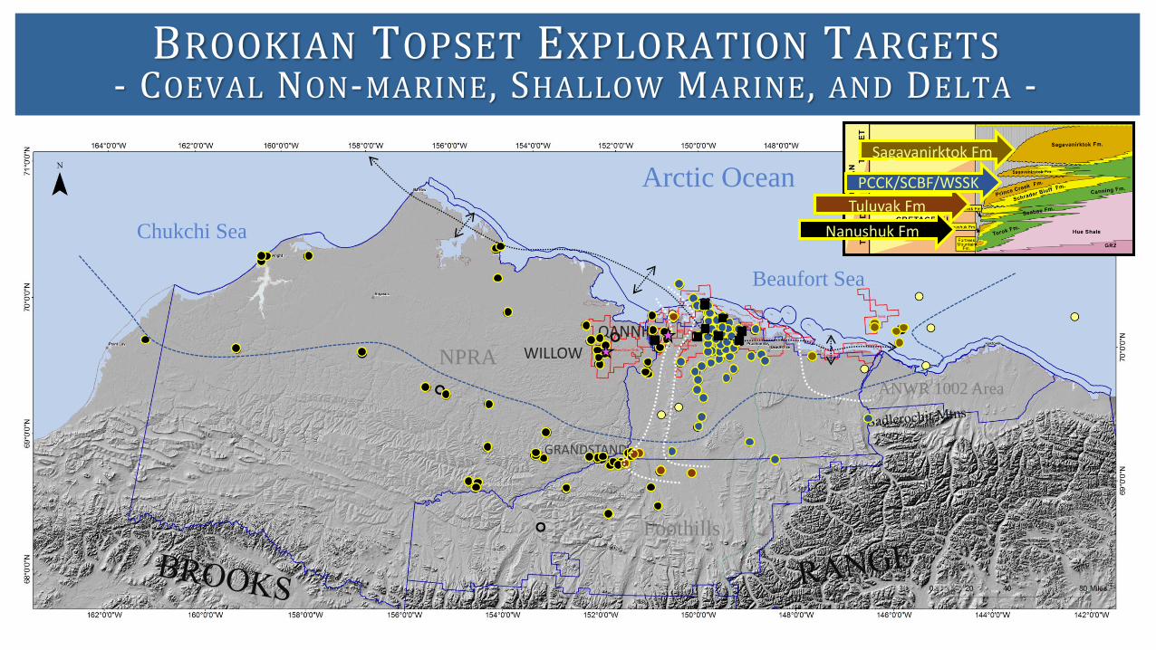
BROOKIAN TOPSET EXPLORATION TARGETS- COEVAL NON-MARINE, SHALLOW MARINE, AND DELTA -
Beaufort Sea
Chukchi Sea
Arctic Ocean
NPRA
ANWR 1002 Area
Foothills
Sagavanirktok Fm
GRANDSTAND
WILLOW
QANNIK
Nanushuk Fm
Tuluvak Fm
PCCK/SCBF/WSSK

EXPLORERS AND DISCOVERERS- ALASKA THANKS YOU -
Data sources: AOGCC; AKDOG; USGS; BOEM; DOE/NETL0 20 40 60 80 100 120 140 160 180 200
ACCUMULATE ENERGY
ASRC
GREAT BEAR
SAVANT
AMERADA HESS
ENI
FEX
N.S. BOROUGH
TECK COMINCO
BROOKS RANGE
PIONEERCaelus
OneWellOperatorsEncanaTotal
HamiltonBroMcCullochCoO&GMalVaugh
ANADARKOKerrMcGee
REPSOLArmstrong
SHELL
ExxonMobilHumbleSinclair
ChevronTexacoUnionUnocalSocalTennGulf
NavyUSGSHuskyOilDOI
BPAmocoSOHIO
ARCOConocoPhillips
Number of Exploration Wells DrilledExplorer
Oil Search
0 20 40 60 80 100 120 140 160 180 200
ACCUMULATE ENERGY
ASRC
GREAT BEAR
SAVANT
AMERADA HESS
ENI
FEX
N.S. BOROUGH
TECK COMINCO
BROOKS RANGE
PIONEERCaelus
OneWellOperatorsEncanaTotal
HamiltonBroMcCullochCoO&GMalVaugh
ANADARKOKerrMcGee
REPSOLArmstrong
SHELL
ExxonMobilHumbleSinclair
ChevronTexacoUnionUnocalSocalTennGulf
NavyUSGSHuskyOilDOI
BPAmocoSOHIO
ARCOConocoPhillips
ELSMJRSCCRCSBRKNturbBRKNtopExploration
Oil Search

The Map and Database of Exploration Drilling Targets Categorized by Play Type, North Slope and Offshore Arctic Alaska is available on the Alaska Division of Oil and Gas’ website: http://dog.dnr.alaska.gov/Information/Studies
MAP & DATABASE OF EXPLORATION DRILLING TARGETS- CUSTOM BUILT FOR ALASKA’S EXPLORERS -

Inside Look at the Database:
MAP & DATABASE OF EXPLORATION DRILLING TARGETS- CUSTOM BUILT FOR ALASKA’S EXPLORERS -
OCS Well Histories & Public Exploration Plans are also available on our studies page:
FOIA Request (BOEM-2018-00218)

EXPLORATION TARGET ABBREVIATIONS- COLOR CODED BY PLAY TYPE: BROOKIAN SEQUENCE -

EXPLORATION TARGET ABBREVIATIONS- COLOR CODED BY PLAY TYPE: BEAUFORTIAN , ELLESMERIAN , & OTHER -

CONCLUSIONS
1. Land availability, pipeline access, and large oil discoveries have historically fueled exploration drilling in North Alaska.
2. Mapping exploration drilling targets by stratigraphic play type highlights regional geologic trends.
3. Ellesmerian reservoirs have contributed more oil than any other play type, with Cretaceous rift reservoirs coming in second.
4. Exploration discoveries in the past two decades have resulted in the Jurassic shoreface reservoirs and Brookian topset reservoirs making up a larger portion of our present day production (22% in 2018).
5. Giant sized oil accumulations are still being discovered in North Alaska (BrookianTopset Play – CPAI & Oil Search/Repsol/Armstrong).
6. The exploration target maps and database are constructed with the explorer in mind: http://dog.dnr.alaska.gov/Information/Studies
7. AK DOG also created a document that highlights public data sources relevant to oil and gas exploration – SALSA: http://dog.dnr.Alaska.gov/Library/SALSA

ACKNOWLEDGEMENTS & DISCLAIMER
Acknowledgements:The authors gratefully acknowledge Kelsey Anderson and Joseph Skutca for their early contributions to the exploration target research in NPRA and state lease sale regions. The authors also gratefully acknowledge Kirk Sherwood for guiding us through the federal data request process for Outer Continental Shelf (OCS) well data. Significant improvements were made to the maps and presentation from feedback and discussions with Kirk Sherwood, Paul Decker, Don Krouskop, Steve Moothart, Kevin Frank, Ken Helmold, Dave LePain, Dan Seamount, Steve Davies, Meredith Guhl, David Boyer, Adam Manzer, Yelena Young, and Sean Clifton. The maps benefited from cartographic expertise provided by Sean Conlon and Marta Mueller.
Disclaimer:This map was created, edited, and published by the State of Alaska, Department of Natural Resources, Division of Oil and Gas, and is for informational purposes only.
The State of Alaska makes no express or implied warranties (including warranties for merchantability and fitness) with respect to the character, functions, or capabilities of the electronic data or products or their appropriateness for any user's purposes. In no event will the State of Alaska be liable for any incidental, indirect, special, consequential, or other damages suffered by the user or any other person or entity whether from the use of the electronic services or products, or any failure thereof or otherwise. In no event will the State of Alaska's liability to the Requestor or anyone else exceed the fee paid for the electronic service or product.