the high resolution wide swath mission and worldsar
TRANSCRIPT

The High Resolution Wide Swath Mission
and WorldSAR The Next Generation of X-Band SAR Services
ISRSE-37, Tshwane
Jürgen Janoth, Markus Jochum, Alexander Kaptein
11th May 2017

1. HRWS Mission Overview
2. HRWS for Environmental Monitoring
3. WorldSAR Concept
Outline
ISRSE-37, 2017, Tshwane, May 11th,, 2014
HRWS & WorldSAR – The Next Generation of X-Band SAR Services
2
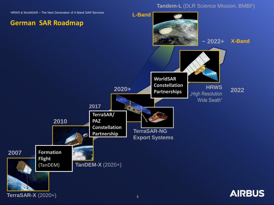
TerraSAR-X (2020+)
TanDEM-X (2020+)
TerraSAR-NG
Export Systems
2020+
~ 2022+
2010
2007
HRWS
„High Resolution
Wide Swath“
German SAR Roadmap
2017
Formation Flight (TanDEM)
TerraSAR/ PAZ Constellation Partnership
WorldSAR Constellation Partnerships
Tandem-L (DLR Science Mission, BMBF)
2022
X-Band
L-Band
HRWS & WorldSAR – The Next Generation of X-Band SAR Services
3

HRWS Mission Background
Mission Context and Status
• Next National Civilian X-Band SAR Mission to continue successful TerraSAR-X Mission
• Partnership approach between DLR Space Administration and Industry
• Phase 0/A Study contracted by DLR to Airbus
• Mission Definition Review May, 16th
• Launch envisaged for 2022
Main User Groups
• National institutional users
• Science users
• Commercial users
• German Defence users (tbc)
4
HRWS & WorldSAR – The Next Generation of X-Band SAR Services
ISRSE-37, 2017, Tshwane, May 11th,, 2014

HRWS Mission Objectives
5
HRWS & WorldSAR – The Next Generation of X-Band SAR Services
ISRSE-37, 2017, Tshwane, May 11th,, 2014
Programmatic and Strategic Objectives:
• Fostering leading German capabilities in X-Band SAR technology
• Support to the overall goals of the German Space Programme
• Ensuring high resolution X-Band data continuity from 2022 onwards
• Continuation of successful EO-commercialisation
Main Scientific and Technical Objectives:
• In-Orbit demonstration of innovative Digital Beam-Forming technologies
• Utilisation of the newly available chirp bandwidth of 1200 MHz
• Formation flight capability to allow for an update/improvement of existing DEM
• Implementation of new modes with improved coverage and high resolution

6
TerraSAR Generation HRWS - High Resolution Wide Swath
Medium resolution and image size
Low resolution & large image size
Very High resolution & very small images
Large Area Coverage
Excellent Resolution
StripMap
ScanSAR
Spotlight
High Resolution or
Large Area Coverage
Very High Resolution and
Large Area Coverage
In-Orbit demonstration of innovative Digital Beam-Forming Technologies
to…
HRWS – Technical Objectives
HRWS & WorldSAR – The Next Generation of X-Band SAR Services
ScanSAR
ISRSE-37, 2017, Tshwane, May 11th,, 2014

7
1 m | TerraSAR-X 25 cm | HRWS Polarimetrie | HRWS
HRWS – Technical Objectives
HRWS & WorldSAR – The Next Generation of X-Band SAR Services
Very high resolution imagery
ISRSE-37, 2017, Tshwane, May 11th,, 2014
8
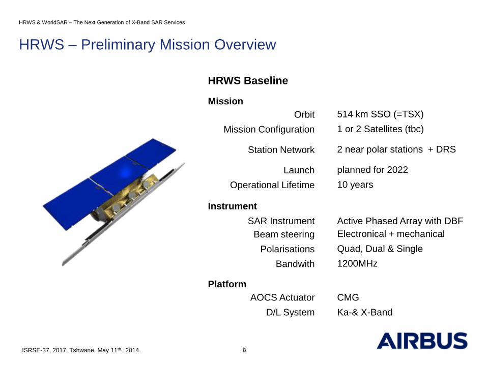
HRWS Baseline
Mission
Orbit 514 km SSO (=TSX)
Mission Configuration 1 or 2 Satellites (tbc)
Station Network 2 near polar stations + DRS
Launch planned for 2022
Operational Lifetime 10 years
Instrument
SAR Instrument Active Phased Array with DBF
Beam steering Electronical + mechanical
Polarisations Quad, Dual & Single
Bandwith 1200MHz
Platform
AOCS Actuator CMG
D/L System Ka-& X-Band
HRWS – Preliminary Mission Overview
HRWS & WorldSAR – The Next Generation of X-Band SAR Services
ISRSE-37, 2017, Tshwane, May 11th,, 2014

TerraSAR-X NG – Orbit Characteristics
Orbit Type Sun-synchronous Dusk Dawn orbit
Orbit repeat cycle 11 days
Orbits per day 15 2/11
Orbits per repeat cycle 167
Mean Revisit SpotLigth Mode @ 0.25 m resolution:19.9 h
Equatorial crossing time 18:00 h +/- 0,25 h (ascending)
06:00 h ± 0.25h (descending)
Inclination 97,44°
Altitude at equator 514,8
Altitude variation 505 - 527 km
Attitude steering Total Zero Doppler Steering
Orbit Tube 500 m diameter (Design goal 200 m)
9
HRWS – Orbit Characteristics (preliminary)
HRWS & WorldSAR – The Next Generation of X-Band SAR Services
ISRSE-37, 2017, Tshwane, May 11th,, 2014

10
… mono-static … or bi-static with two sensors
HRWS – Imaging Modes
ISRSE-37, 2017, Tshwane, May 11th,, 2014

Mode Resolution Polarisation Scene Size /
Swath Width
Performance
Range
VHS 0.25 0.25 m Single 15 x 15 km² 20°- 55°
VHS 0.5 0.5 m Dual, Quad 25 x 25 km² 20°- 45°
SM 1 1.0 m Single 45 km 20°- 45°
SM 2 2.0 m Dual, Quad 20 km 20°- 45°
SM 3 3.0 m Single 60 km 20°- 45°
SM 3 3.0 m Dual, Quad 30 km 20°- 45°
SM 5 5.0 m Single 80 km 20°- 45°
SC / TOPS 8 8.0 m Single 250 km 20°- 45°
SC / TOPS 30 30.0 m Single 500 km 20°- 50°
HRWS – Selected Modes (preliminary)
ISRSE-37, 2017, Tshwane, May 11th,, 2014 11

12
HRWS & WorldSAR – The Next Generation of X-Band SAR Services
ISRSE-37, 2017, Tshwane, May 11th,, 2014
Direct Receiving
Stations
Space Segment
SAR Instrument
Satellite Bus
(Opt.)Secondary
Payload AIS
Ground Segment
Direct Receiving
Station
Telecommand/
Telemetry
Service Segment
Enterprise Resource
PlanningValue Adding Component
Web Services
Order ServicesProduction Archiving &
Delivery Services
Reporting
User Segment
Direct Receiving
Customers
Distribution
Partner
Standard
Users
Datatake
Keys
Products
Proposals,
Sales Orders
Extended
Planning Data
Customer
Notifications
Pro
du
cts
National Institutional
Science Commercial
National Defence
Direct Receiving
StationDirect Receiving
Station
Raw Data
Pass Booking
Basic
Products
Datatake
Keys
Black List
Sanction List
Product
Release
Telecommand
Security Mgmnt System
Constellation
Partner
Regulatory
Entities
EU
BAFA
Airbus
Catalogue/Future Acq.
Browse & Order
Catalogue/Future Acq.
Browse & Order
Territorial
Authorities
Archiving & Catalogue
Mission Control- Satellite Control
- Instrument Control
- Flight Dynamics System
GS Crypto Elements SAR Processing Chain
Ground Stations & NetworkMission Planning
Central Services- Monitoring & Control
- Workflow & Processing Mgmnt
- POD Service
- Space Data Mgmnt
GS IT Infrastructure
Radar Data
Downlink
(Option LCT /EDRS)
Radar Data
Downlink
(Option LCT /EDRS)
Maintenance Module
Visual Order Analysis
Health Monitoring Client
HRWS Image Products and Services
• Basic Image Products (L1B)
• Multi-Look Ground range Detected (MGD, GEC, EEC)
• Single look Slant range Complex (SSC)
• New application specific processing variants
• Geo-Information Products and Services
• Maritime Surveillance, GCP, Surface Motion
Monitoring, DEMs, Change Detection
Data access and dissemination
• Data access subject to German Satellite Security Act
• Web based acquisition and catalogue browsing
• On-line product delivery via Delivery Server
• Off-line product delivery via Media Production System
• On-Line Streaming Services envisaged
HRWS – Products and Data Access

Outline
1. HRWS Mission Overview
2. HRWS for Environmental Monitoring
3. WorldSAR Concept
HRWS & WorldSAR – The Next Generation of X-Band SAR Services
13 ISRSE-37, 2017, Tshwane, May 11th,, 2014

HRWS for Environmental Monitoring
14
HRWS & WorldSAR – The Next Generation of X-Band SAR Services
ISRSE-37, 2017, Tshwane, May 11th,, 2014
HRWS Mission Drivers
• Multi-user Mission with following key applications:
• Surface Motion Monitoring
• Environmental Monitoring / Thematic Mapping
• Maritime Surveillance
• Image Intelligence
Observation Planning
• On- request plus back ground mission (single Satellite)
• Systematic global acquisition plus on-request (Formation)
Specific HRWS Contribution Potential
• Contribution particular to UNFCCC and REDD+, Ramsar Wetlands due to
• Large area coverage at high resolution (e.g. improved detection rate for logged trees)
• Quad Polarisation
• Bi-static acquisitions (in case of a formation)

Contribution of TanDEM-X
interferometic coherence
HRWS for Environmental Monitoring
HRWS & WorldSAR – The Next Generation of X-Band SAR Services
15 ISRSE-37, 2017, Tshwane, May 11th,, 2014

Outline
1. HRWS Mission Overview
2. HRWS for Environmental Monitoring
3. WorldSAR Concept
HRWS & WorldSAR – The Next Generation of X-Band SAR Services
16 ISRSE-37, 2017, Tshwane, May 11th,, 2014

WorldSAR Concept
17
WorldSAR Alliance
• Co-operation of independent spacecraft owners/operators
• Subscribers own observation capacity and
gain constellation benefits through WorldSAR partners
Objectives
• Shorting the revisit time and the interferometric repeat cycle
• Enlarging coverage capacity
Secondary Benefits
• Reliability of delivery by mutual back-stopping in case of
mission maintenance of failure
• Monitoring continuity (incuding the use of heritage modes)
across missions and technology generations
HRWS & WorldSAR – The Next Generation of X-Band SAR Services
ISRSE-37, 2017, Tshwane, May 11th,, 2014

TerraSAR-X (2007) TanDEM-X (2010)
PAZ (2017)
HRWS (2022)
WorldSAR
Constellation cooperation
with Hisdesat (ES)
WorldSAR Next Generation
PAZ
HRWS
Export Mission(s)
Export Type A Export Type B
14.07.2017 18
HRWS & WorldSAR – The Next Generation of X-Band SAR Services
ISRSE-37, 2017, Tshwane, May 11th,, 2014 18
WorldSAR Concept – Current and Future Missions

Jürgen Janoth
Head of R&D SAR
Intelligence, Airbus Defence and Space
Mailing: 88039 Friedrichshafen | Germany
Courier: Claude-Dornier-Str. | 88090 Immenstaad |
Germany
Tel +49 7545 8 4291 | Fax +49 7545 8 1337 |
19
Thank You for your Attention!