the has landeda new generation complete ready-to-fly uav in a complete package that enables users to...
TRANSCRIPT

The
has landed
100% Made in Germany

A new generation complete Ready-to-Fly UAV in a complete package that enables users to survey terrains efficiently, safely, with high accuracy. Orthography of up to 1mm resolution and 3D models can be generated with ease with accompanying software. The HoverHawk is fully designed, assembled and tested in Germany.
PRIMARY APPLICATION
• Disaster site monitoring, scanning, and rescue facilitation• Aerial prowling and surveillance for security applications• Traffic control and management • Observation of wildlife and nature with minimal intrusion • Aerial photo taking for sightseeing tours, events, and leisure • Agriculture land survey and plot management• Military surveillance applications • General environmental surveillance
• Manual or fully automated aerial survey, mapping, and image capturing of various terrains, cities, landscapes, and structures. The images can be post processed to generate point clouds or 3D images efficiently post-flight with software like Pix4D.
With the HoverHawk, the application possibilities are many, and not limited to the ones listed above.
OTHER POSSIBLE APPLICATIONS*
• Complete, Ready to Fly, and competitive package• Generate georeferenced photos to build detailed orthophotos, digital elevation models, point clouds, 3D models etc• Camera system and flight planning software included• High stability flying in windspeeds of up to 15m/second • Compact and lightweight 6-rotor carbon fiber frame • Full redundancy system for approved operation in Austria and other countries with stringent requirements (optional)• Outstanding innovation designed and assembled in Germany. Winner of the Innovation Prize 2014
PRODUCT FEATURES AT A GLANCE
The HoverHawk is powered by the proven and award winning MULTIROTER G4 technology, founded in Germany. The hardware and supporting systems are also 100% designed and assembled in Germany supported by rigorous and no-expenses spared research and development, precision engineering, and extensive field testing prior to launch.
The state of the art MULTIROTER flight control system equipped with each HoverHawk allows for unprecedented precision and stability in the flight and measurement process. At the core of the flight control system is a 32-bit dual processor board, supported by a 10-fold higher computing capacity, state of the art hardware components and circuitry, a 128Hz measurement data log and a referenced GPS system.
The HoverHawk package contains everything that users would require for an out-of-box usage and operation. Besides the UAV unit, included are a fully integrated camera system to facilitate fully automated image capturing, and a flight planning software package. Georeferenced photos can be generated with ease and speed, and detailed orthophotos with 1mm ground resolution can be built, along with digital elevation models (DEM), point clouds, volume and area calculations, and 3D models. The HoverHawk value adds to any surveying process in terms of efficiency, user safety, and easy facilitation of post-processing work. The processing of georeferenced photos can be done with software readily available in the market, like Pix4D and Agisoft.
Last but not least, The HoverHawk is also built with competitiveness of price in mind to allow users to access this previously costly technology.
PRODUCT DESCRIPTION
Disaster site monitoring Nature observation
Events Agriculture
*- Certain applications may require optional accessories to be purchased separately. HORIZON is also able to supply other application specific UAV models upon enquiry
Aerial mapping Volume calculation 3D model generation
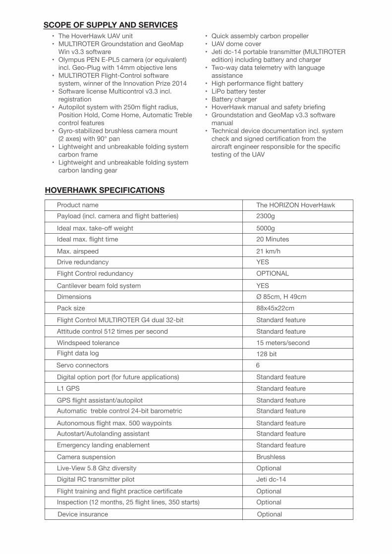
• The HoverHawk UAV unit• MULTIROTER Groundstation and GeoMap Win v3.3 software• Olympus PEN E-PL5 camera (or equivalent) incl. Geo-Plug with 14mm objective lens• MULTIROTER Flight-Control software system, winner of the Innovation Prize 2014• Software license Multicontrol v3.3 incl. registration• Autopilot system with 250m flight radius, Position Hold, Come Home, Automatic Treble control features• Gyro-stabilized brushless camera mount (2 axes) with 90° pan• Lightweight and unbreakable folding system carbon frame• Lightweight and unbreakable folding system carbon landing gear
• Quick assembly carbon propeller • UAV dome cover• Jeti dc-14 portable transmitter (MULTIROTER edition) including battery and charger• Two-way data telemetry with language assistance• High performance flight battery• LiPo battery tester• Battery charger• HoverHawk manual and safety briefing• Groundstation and GeoMap v3.3 software manual• Technical device documentation incl. system check and signed certification from the aircraft engineer responsible for the specific testing of the UAV
SCOPE OF SUPPLY AND SERVICES
Product namePayload (incl. camera and flight batteries)
Ideal max. take-off weightIdeal max. flight time
Max. airspeedDrive redundancyFlight Control redundancy
Cantilever beam fold systemDimensionsPack size
Flight Control MULTIROTER G4 dual 32-bitAttitude control 512 times per secondWindspeed toleranceFlight data log
Servo connectors
Digital option port (for future applications)L1 GPS
GPS flight assistant/autopilotAutomatic treble control 24-bit barometric
Autonomous flight max. 500 waypointsAutostart/Autolanding assistantEmergency landing enablement
Camera suspensionLive-View 5.8 Ghz diversityDigital RC transmitter pilot
Flight training and flight practice certificateInspection (12 months, 25 flight lines, 350 starts)
Device insurance
The HORIZON HoverHawk2300g
5000g20 Minutes
21 km/hYESOPTIONAL
YESØ 85cm, H 49cm88x45x22cm
Standard featureStandard feature15 meters/second128 bit6
Standard featureStandard feature
Standard featureStandard feature
Standard featureStandard featureStandard feature
BrushlessOptionalJeti dc-14
OptionalOptional
Optional
HOVERHAWK SPECIFICATIONS

SINGAPORE SURVEY INSTRUMENTS SERVICES PTE LTDTel: (65) 6288 4622Fax: (65) 6288 2033Email: [email protected]
BRAZILMÉTRICA TECNOLOGIA E EQUIPAMENTOSTel: +55 19 3432 5556Email: [email protected]
CHINASIS SHANGHAITel: +86 21 6236 0569Fax: +86 21 6236 0614
COLOMBIAELBER DE J. HERNANDEZ D-INGENIERIACIVIL & AMBIENTALTel: 011 57 4215 441Fax: 011 57 4139 964
EUROPEHORIZON INSTRUMENTS B.VTel: +31 485 361 053Fax: +31 485 361 054Email: [email protected]
INDIAANSARI PRECISION INSTRUMENTS PVT LTDTel: +91 1332 261277Fax: +91 1332 264277Email: [email protected]
INDONESIAPT KESUMATel: (62) 21 7591 7538Fax: (62) 21 7591 7537
MALAYSIASURMAP SDN. BHD.Tel: +603 5633 8877Fax: +603 5880 9960
THE PHILIPPINESSICCION MARKETING, INCTel: 63 2732 6771Fax: 63 2732 8647Email: [email protected]
USAHORIZON MEASUREMENTS INC.Tel: +1 909 889 6020Fax: +1 909 889 6080Toll Free: 1 888 710 8282
www.horizon.sg
Product typeLensLens mountEquivalent focal length ona 35 mm film cameraProduct typeNo. of total pixelsNo. of effective pixelsScreen sizeAspect ratioSensorField of viewTotal no. of pixelsProduct typeShutterFocusing pointsMetering system
Metered range
ISO sensitivity
Digital camera with interchangeable Micro Four Thirds Standard lens system
Olympus digital camera E-PL5
M.Zuiko Digital, Micro Four Thirds System LensMicro Four Thirds mountApprox. twice the focal length of the lens
4/3" Live MOS sensorApprox. 17,200,000 pixelsApprox. 16,050,000 pixels17.3 mm (H) × 13.0 mm (V)1.33 (4:3)Uses Live MOS sensor100%Approx. 460,000 dots (aspect ratio 16 : 9)Computerized focal-plane shutter1/4000 – 60 sec., bulb photography, time photography35 points
200 - 25600 (1/3, 1 EV step)Exposure compensationMemory
±3 EV (1/3, 1/2, 1 EV step)SD/SDHC/SDXC/Eye-Fi card (supports UHS-I)
Recording system Digital recording, JPEG (in accordance with Design rule for Camera Filesystem (DCF)), RAW Data, MP format
Applicable standards Exif 2.3, Digital Print Order Format (DPOF), PRINT Image Matching III,PictBridge
Drive mode Single-frame shooting/Sequential shooting/Self-timerSequential shooting Up to 8 fpsSync speed 1/250 s or slowerBattery Li-ion Battery ×1Dimensions 110.5 mm (W) × 63.7 mm (H) × 38.2 mm (D) (4.4" × 2.5" × 1.8")Humidity 30% - 90% (operation)/10% - 90% (storage)
EV 0 - 20 (Digital ESP metering/Center weighted averaging metering/Spot metering)
TTL metering system (imager metering)Digital ESP metering/Center weighted averaging metering/Spot metering
CAMERA SPECIFICATIONS